Total solar eclipse of 06/02/-0389
| Day of week: | Tuesday |
| Maximum duration of eclipse: | 07m04s |
| Maximum width of eclipse path: | 250 km |
| Saros cycle: | 60 |
| Coverage: | 100% |
| Magnitude: | 1.0769 |
| Gamma: | -0.098 |
Wo kann man die Sonnenfinsternis vom 06/02/-0389 sehen?
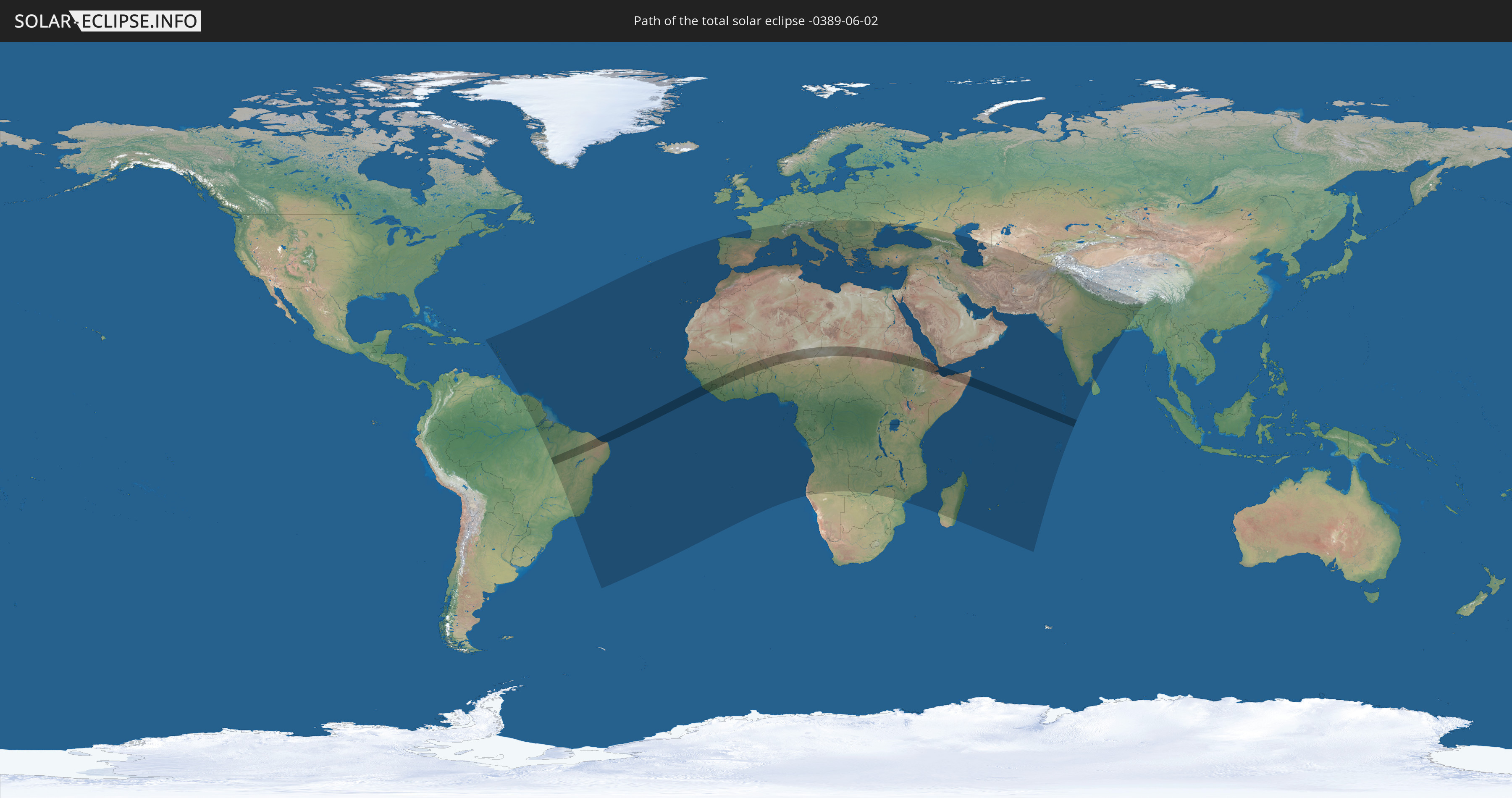
Die Sonnenfinsternis am 06/02/-0389 kann man in 127 Ländern als partielle Sonnenfinsternis beobachten.
Der Finsternispfad verläuft durch 18 Länder. Nur in diesen Ländern ist sie als total Sonnenfinsternis zu sehen.
In den folgenden Ländern ist die Sonnenfinsternis total zu sehen
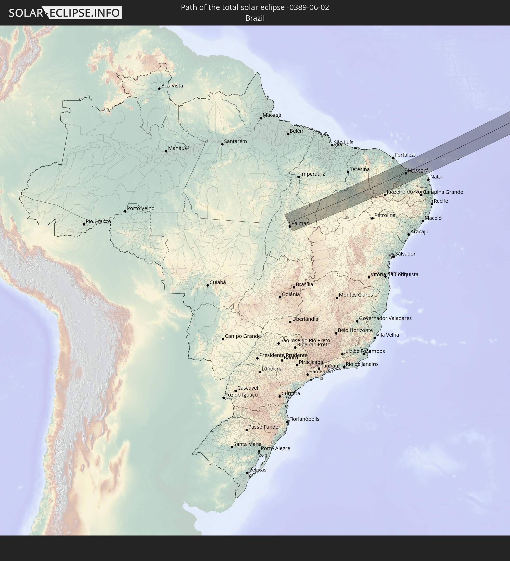 Brazil
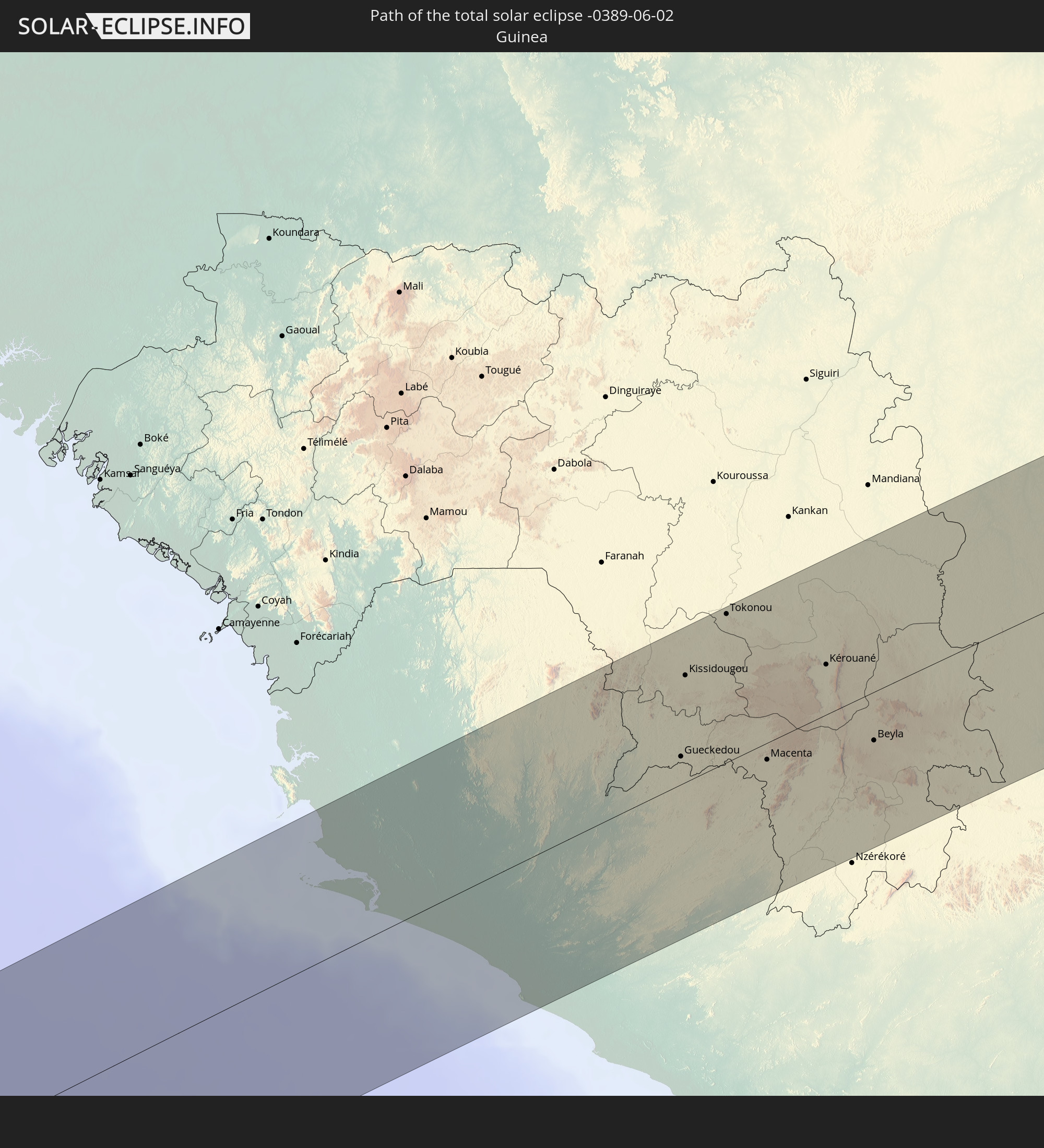 Guinea
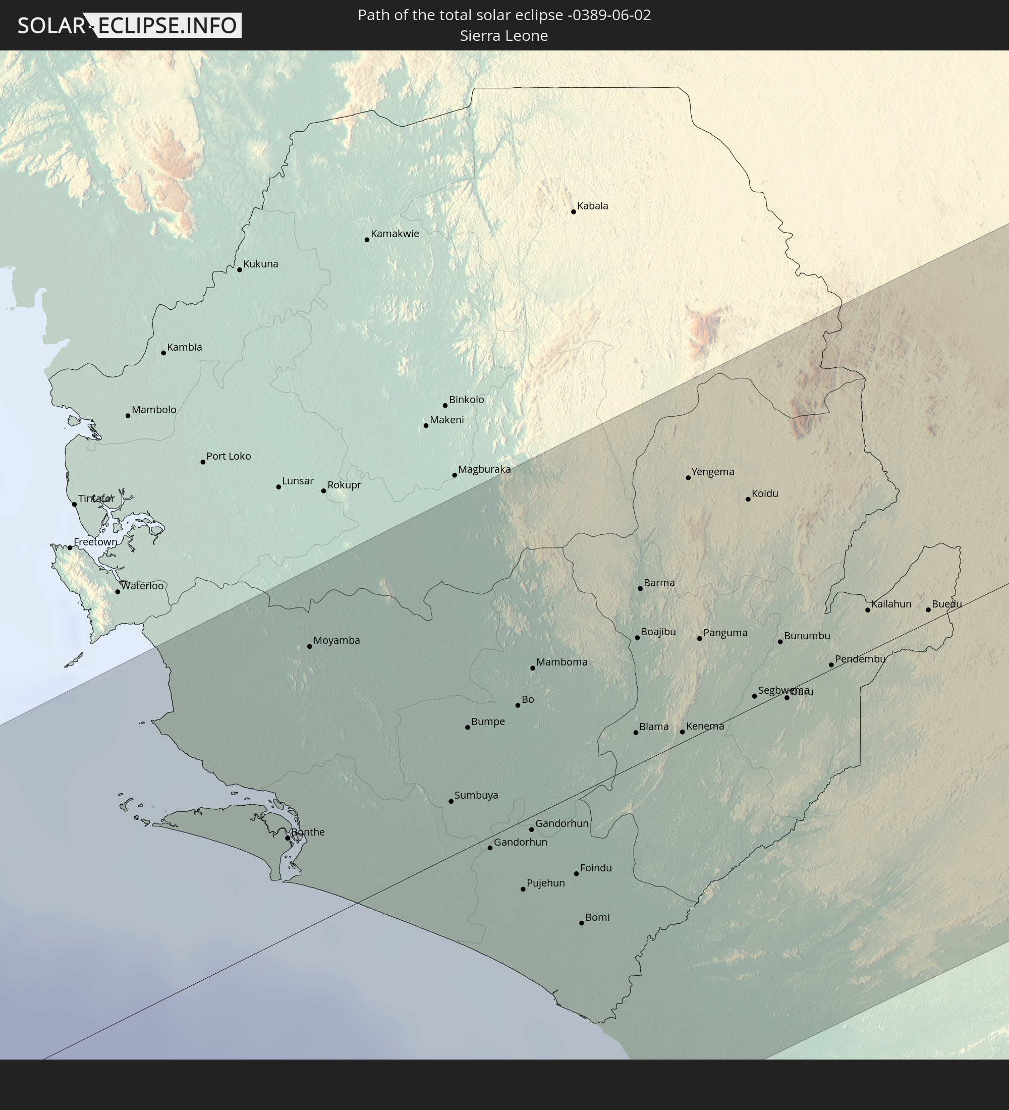 Sierra Leone
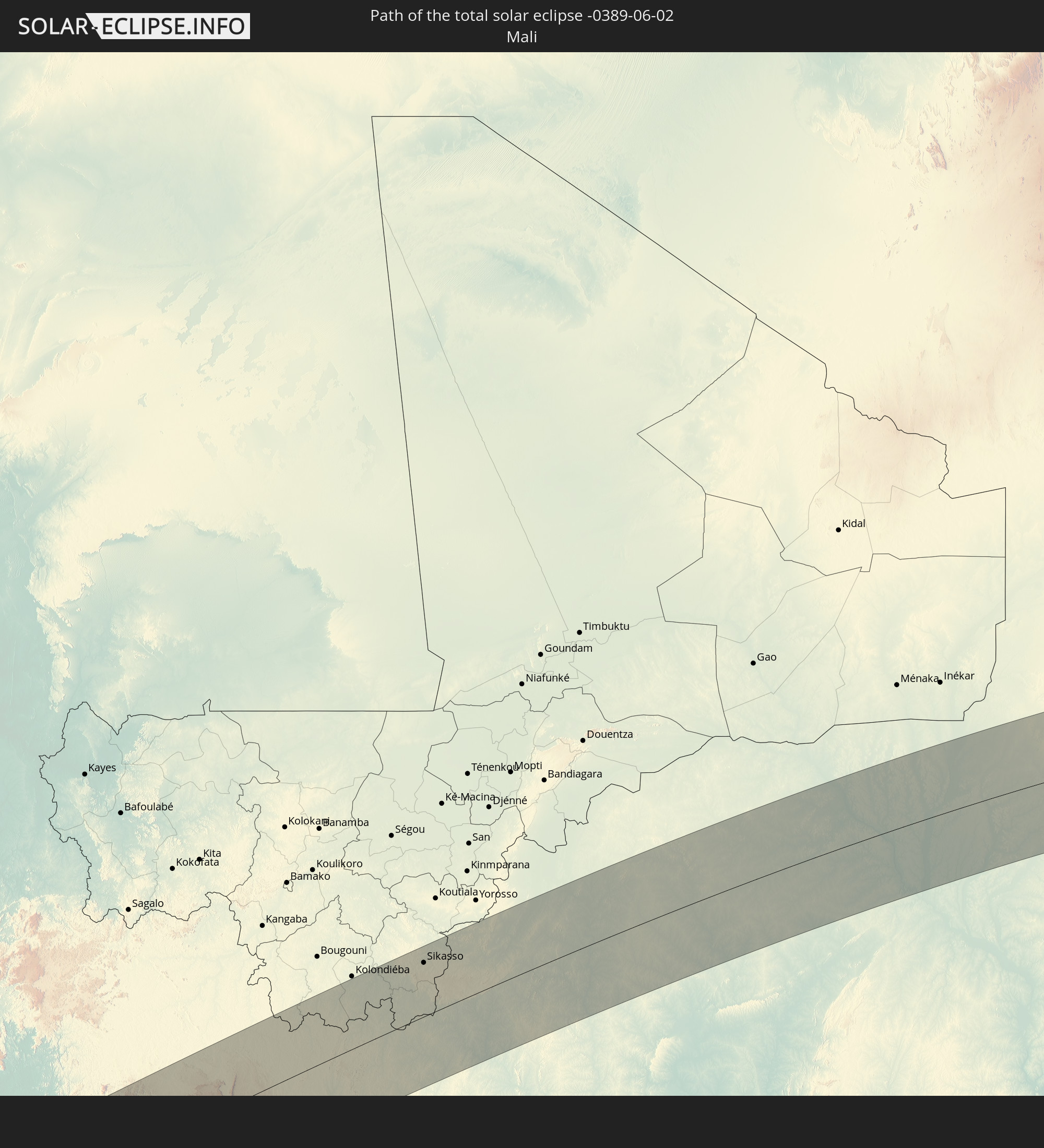 Mali
Mali
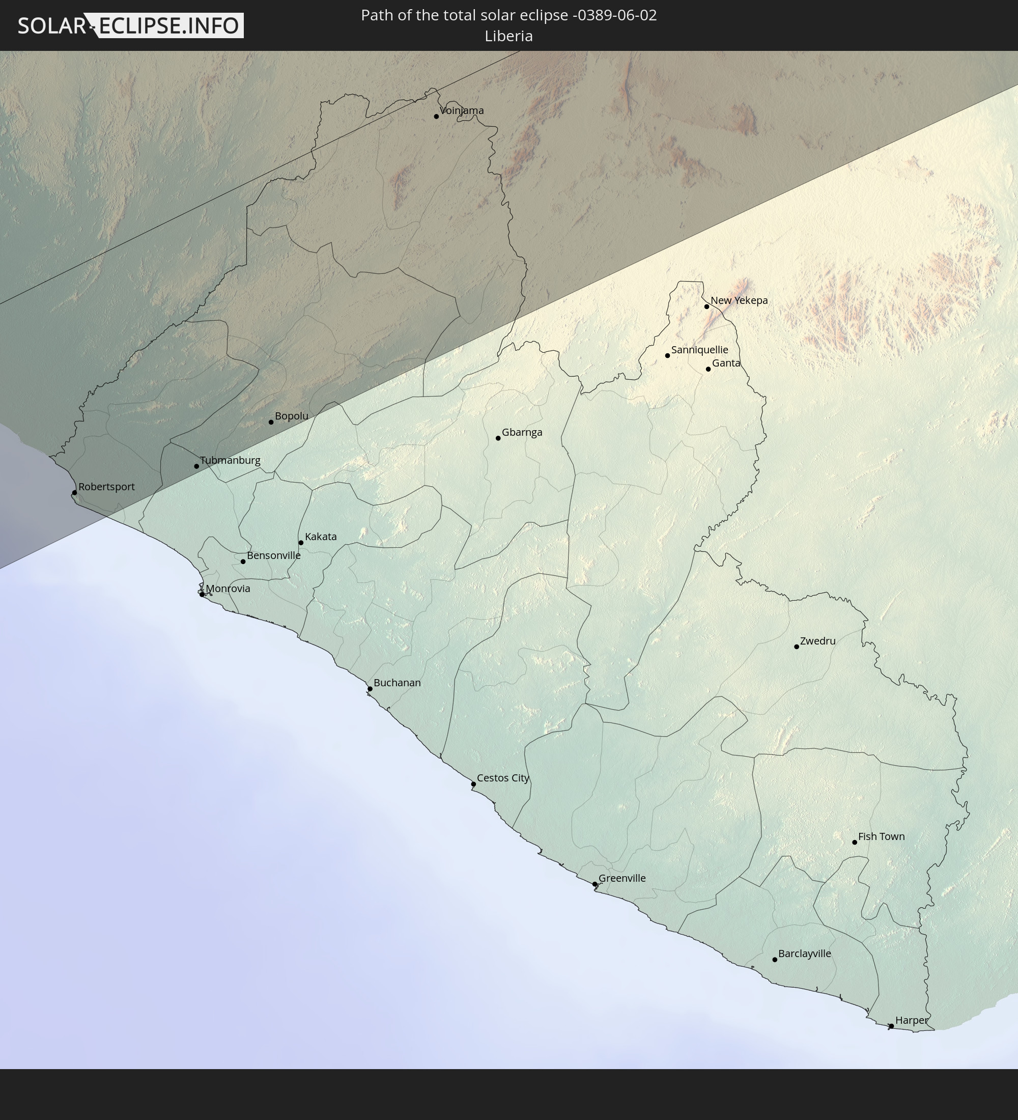 Liberia
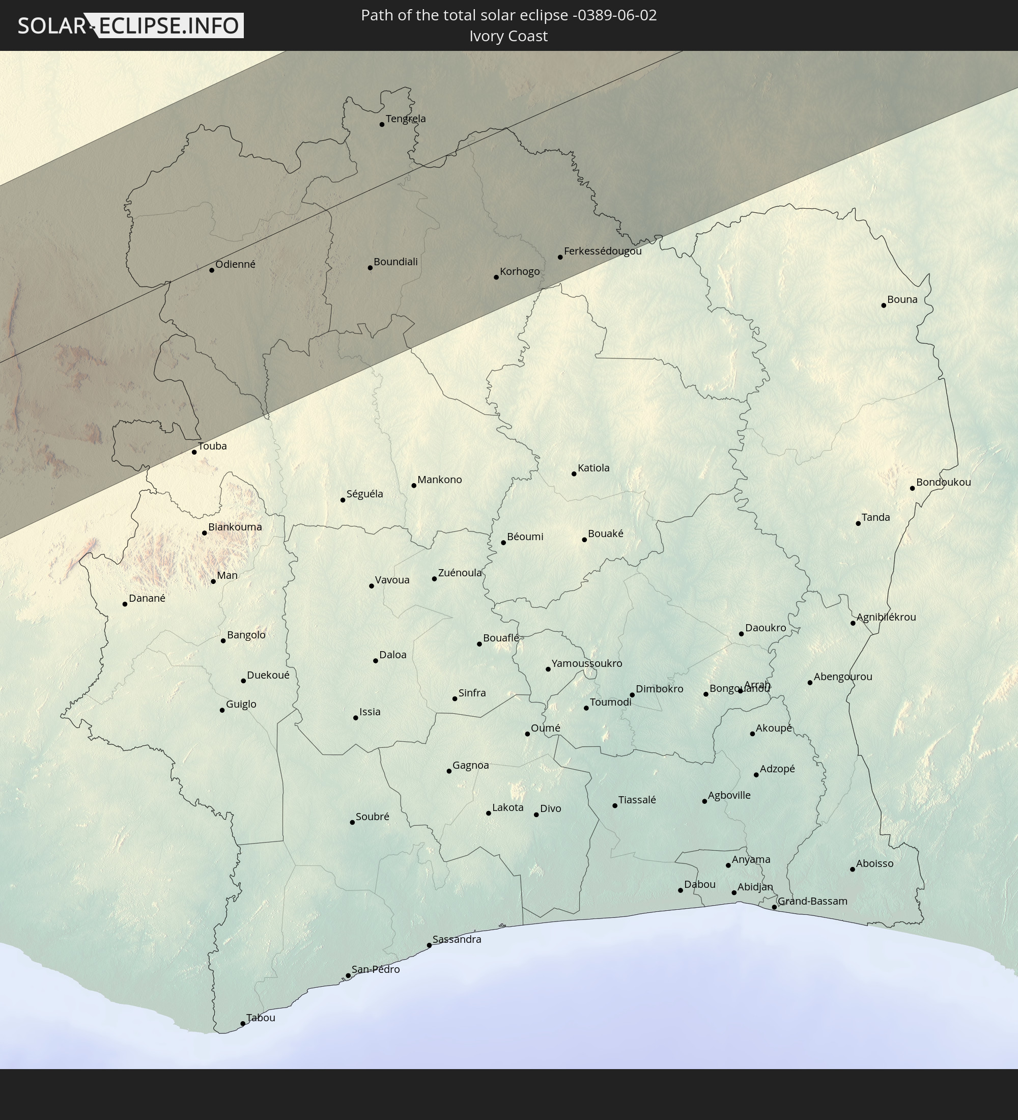 Ivory Coast
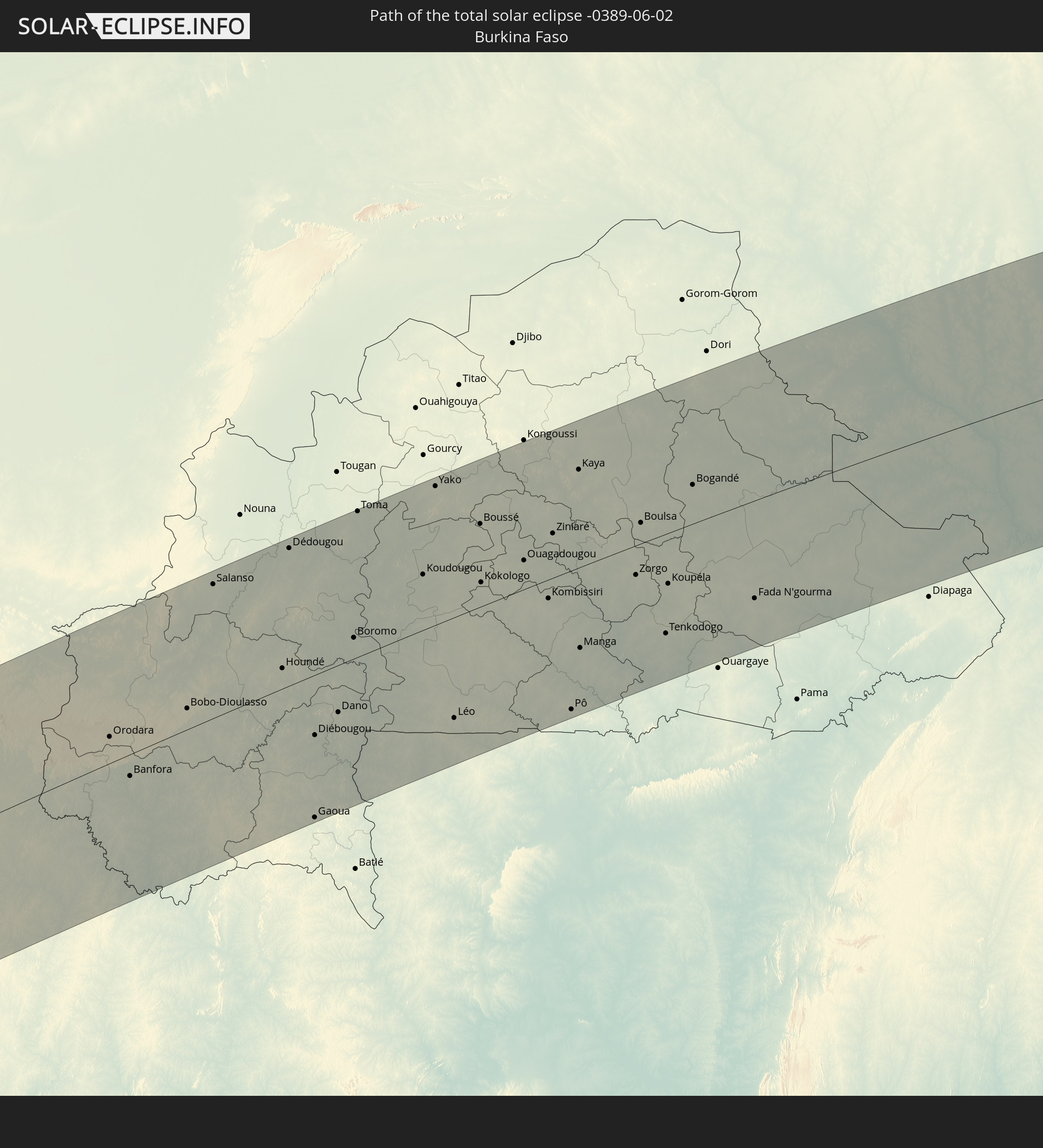 Burkina Faso
 Ghana
Ghana
 Niger
Niger
 Nigeria
 Chad
Chad
 Sudan
Sudan
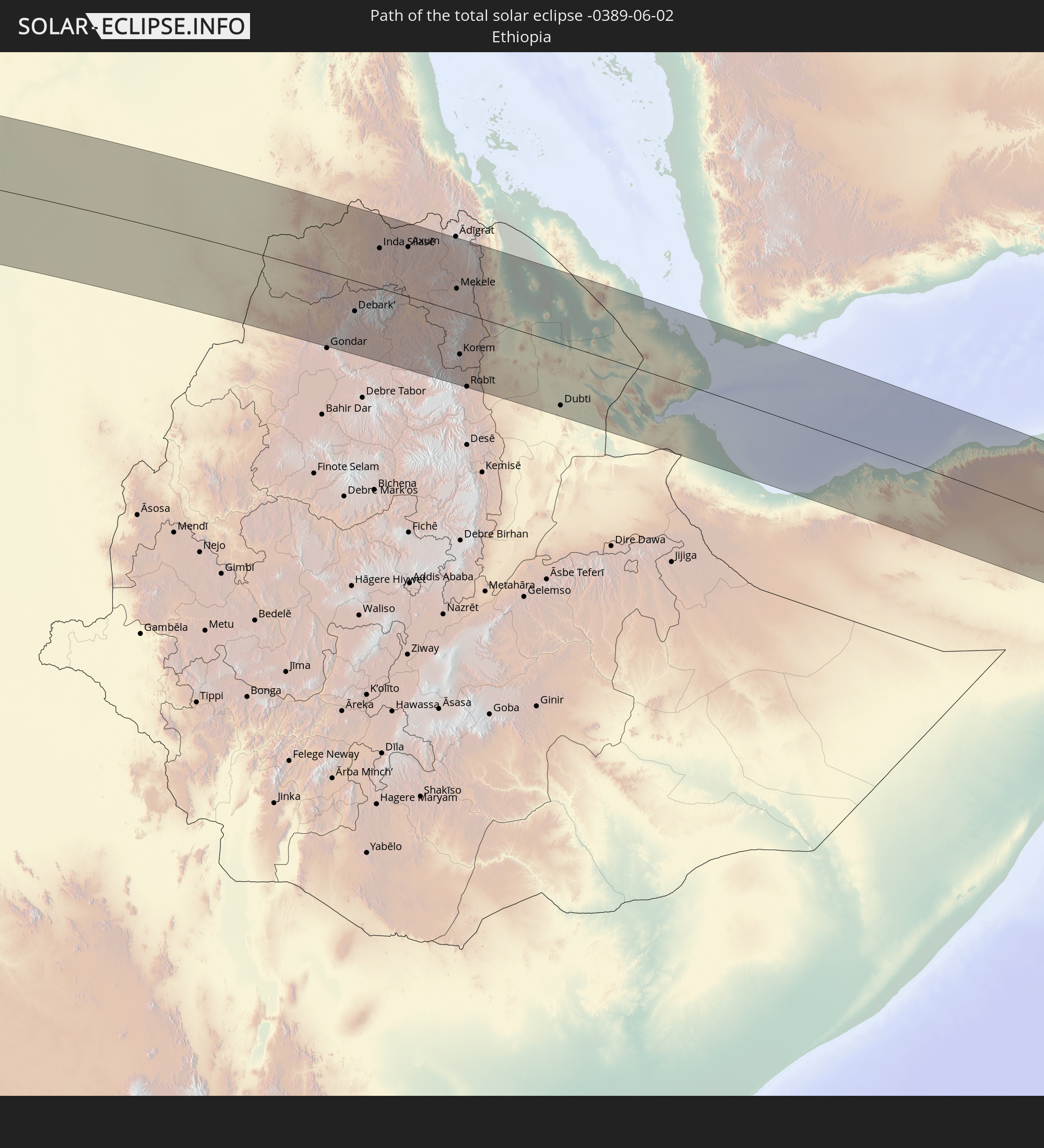 Ethiopia
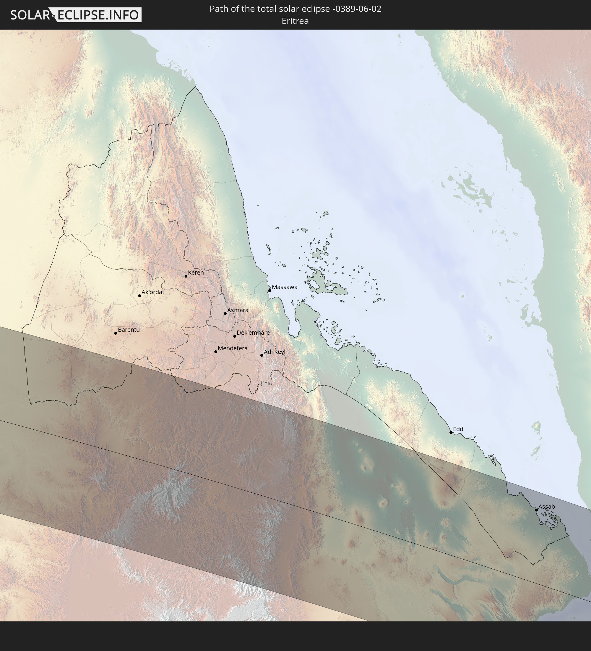 Eritrea
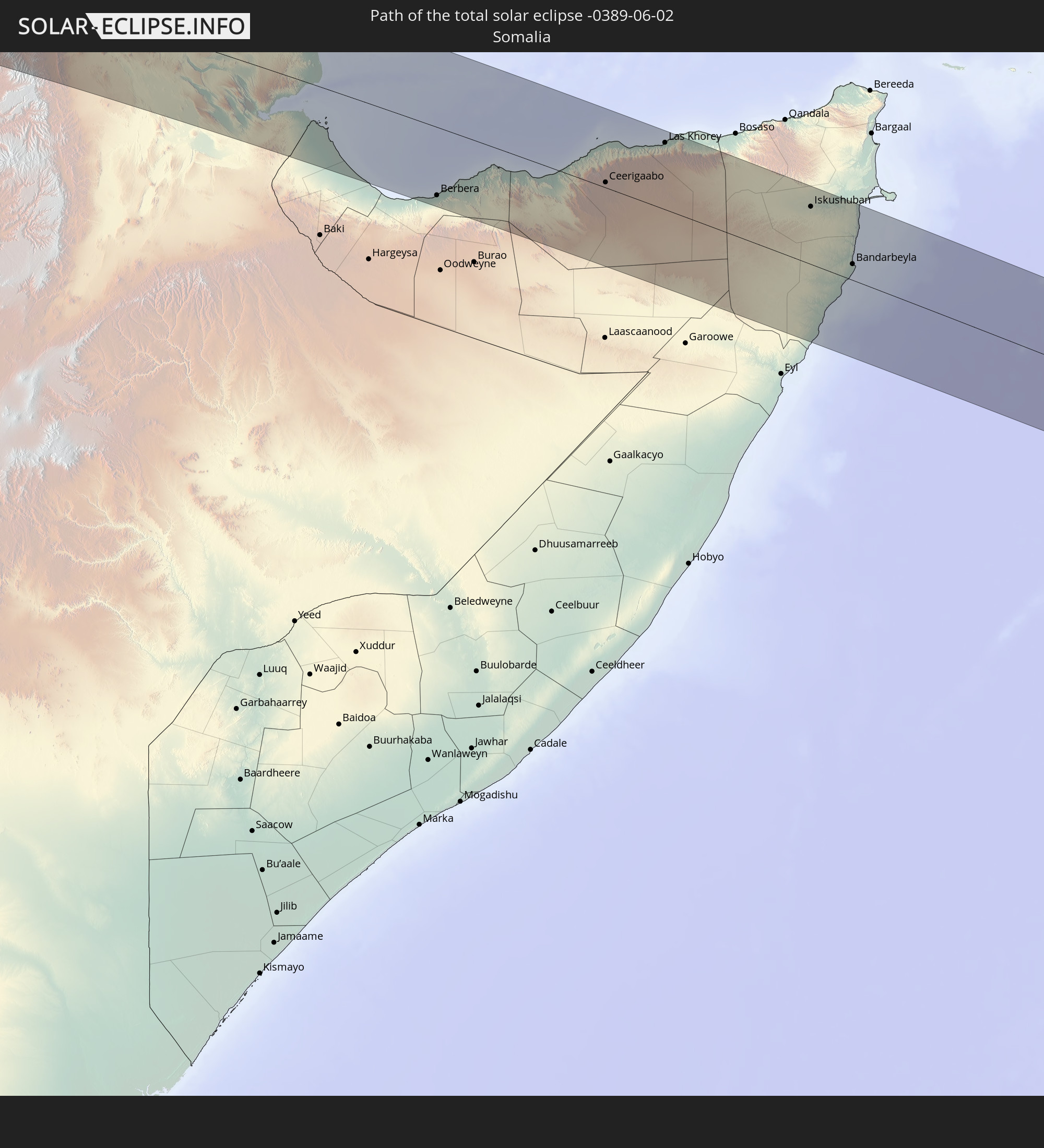 Somalia
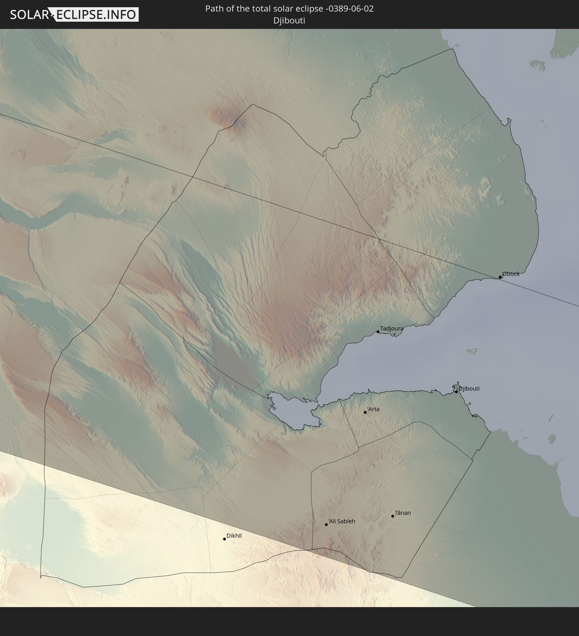 Djibouti
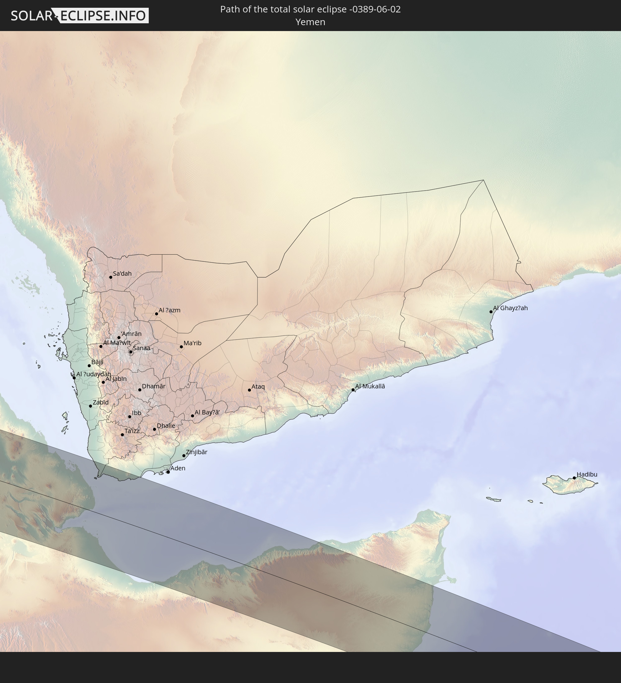 Yemen
Yemen
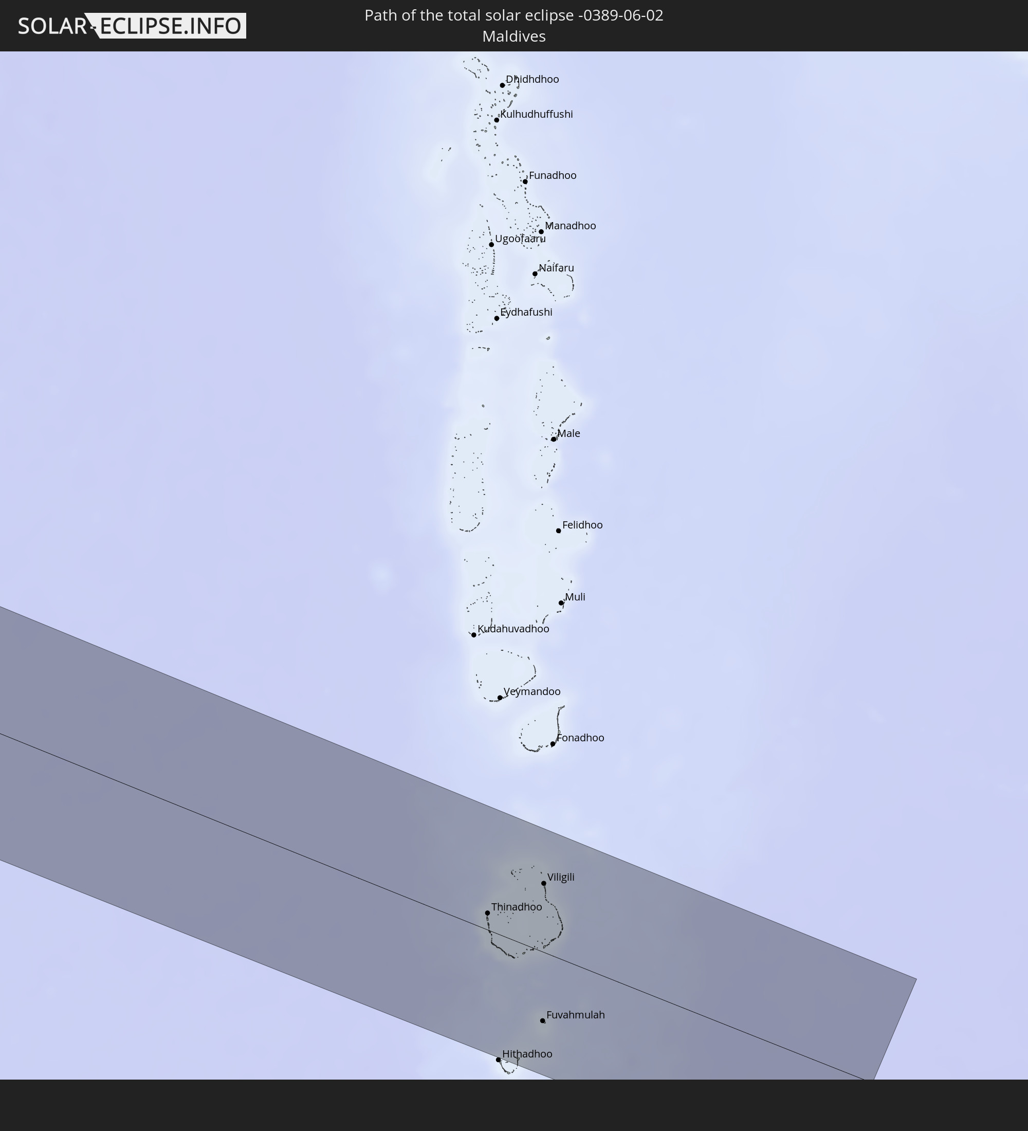 Maldives
In den folgenden Ländern ist die Sonnenfinsternis partiell zu sehen
 Russia
 Brazil
 Anguilla
 Collectivity of Saint Martin
 Saint Barthélemy
 Saint Kitts and Nevis
 Antigua and Barbuda
 Montserrat
 Guadeloupe
 Dominica
 Martinique
 Saint Lucia
 Barbados
 Suriname
 French Guiana
 Portugal
 Cabo Verde
 Spain
Spain
 Senegal
 Mauritania
 The Gambia
 Guinea-Bissau
 Guinea
 Saint Helena, Ascension and Tristan da Cunha
 Sierra Leone
 Morocco
 Mali
Mali
 Liberia
 Algeria
 Ivory Coast
 Burkina Faso
 Gibraltar
 France
 Ghana
Ghana
 Togo
Togo
 Niger
Niger
 Benin
Benin
 Andorra
 Nigeria
 Equatorial Guinea
 Switzerland
 São Tomé and Príncipe
 Italy
Italy
 Monaco
 Tunisia
 Cameroon
 Gabon
Gabon
 Libya
Libya
 Liechtenstein
 Austria
 Republic of the Congo
 Angola
 Namibia
 Democratic Republic of the Congo
 San Marino
 Vatican City
 Slovenia
 Chad
Chad
 Croatia
 Malta
Malta
 Central African Republic
 Bosnia and Herzegovina
 Hungary
 Montenegro
 Serbia
 Albania
 Greece
 Romania
 Republic of Macedonia
 Sudan
Sudan
 Zambia
 Ukraine
 Bulgaria
 Egypt
Egypt
 Zimbabwe
 Turkey
 Moldova
 Rwanda
 Burundi
 Tanzania
 Uganda
 Mozambique
 Cyprus
 Malawi
 Ethiopia
 Kenya
Kenya
 State of Palestine
 Israel
 Saudi Arabia
 Jordan
 Lebanon
 Syria
Syria
 Eritrea
 Iraq
Iraq
 Georgia
 French Southern and Antarctic Lands
 Somalia
 Djibouti
 Yemen
Yemen
 Madagascar
 Comoros
 Armenia
 Iran
Iran
 Azerbaijan
 Mayotte
 Seychelles
 Kazakhstan
 Kuwait
 Bahrain
 Qatar
Qatar
 United Arab Emirates
 Oman
Oman
 Turkmenistan
 Réunion
 Uzbekistan
 Mauritius
 Afghanistan
 Pakistan
 Tajikistan
 India
India
 British Indian Ocean Territory
 Maldives
 China
China
 Sri Lanka
 Nepal
Nepal
 Bangladesh
 Bhutan
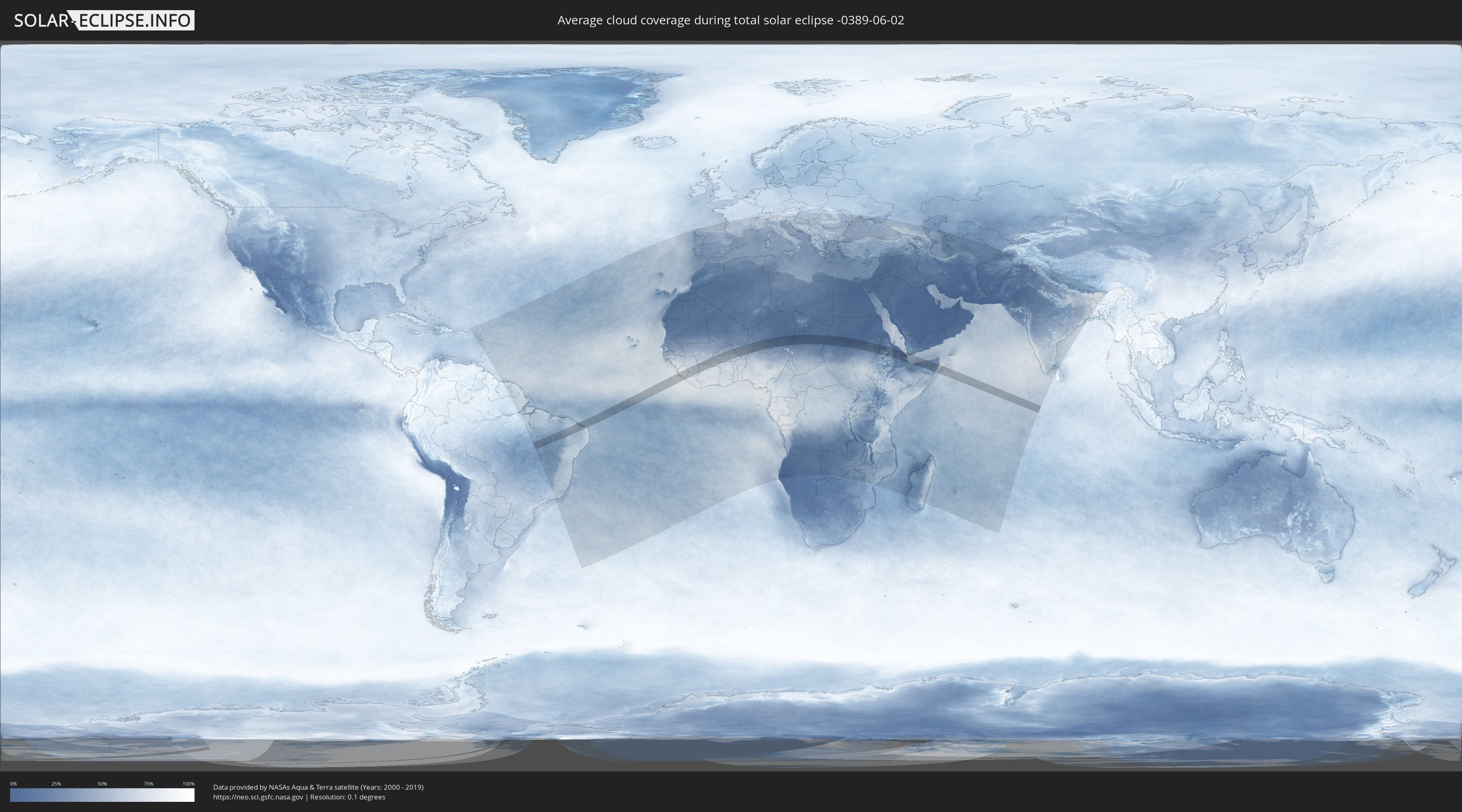
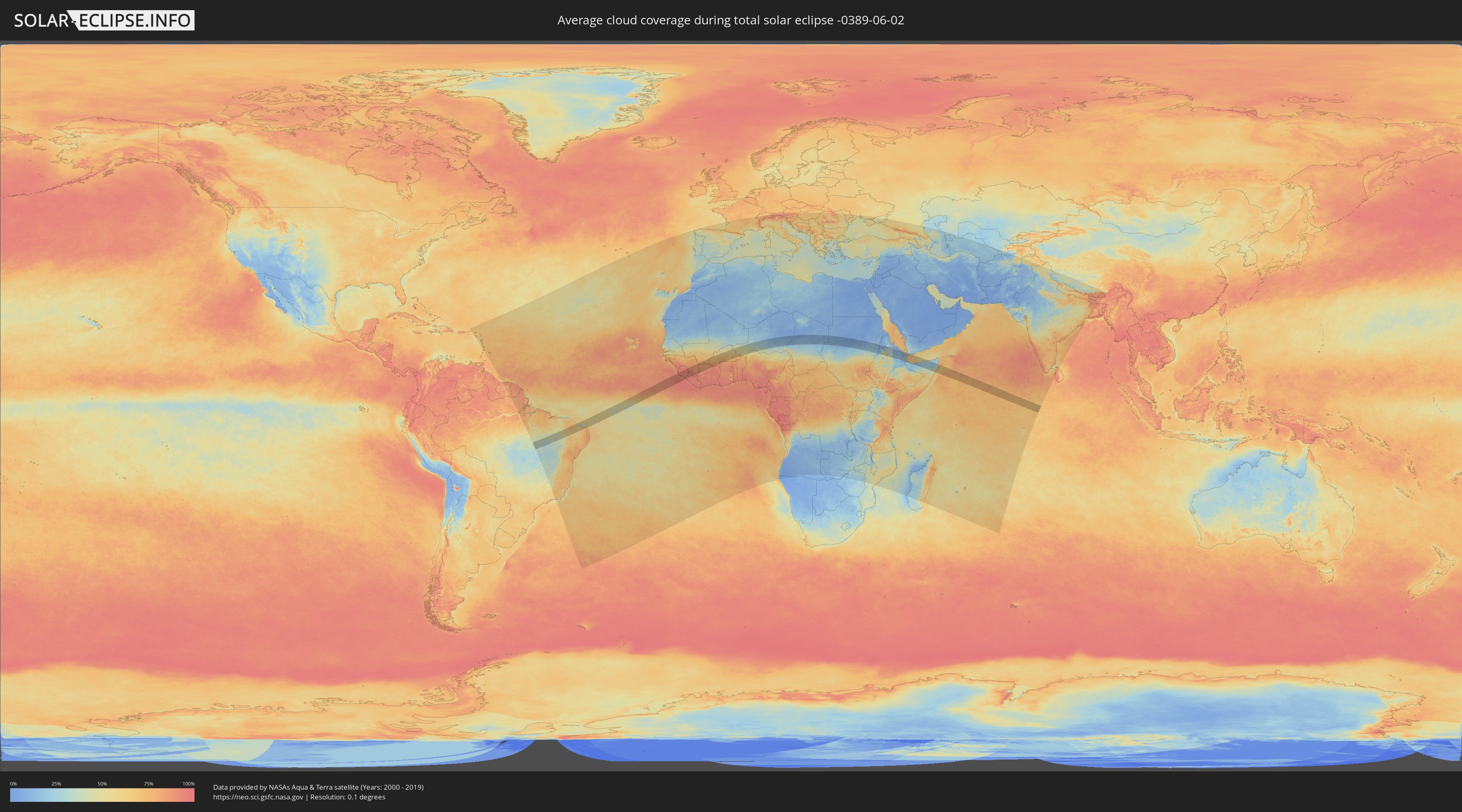
How will be the weather during the total solar eclipse on 06/02/-0389?
Where is the best place to see the total solar eclipse of 06/02/-0389?
The following maps show the average cloud coverage for the day of the total solar eclipse.
With the help of these maps, it is possible to find the place along the eclipse path, which has the best
chance of a cloudless sky.
Nevertheless, you should consider local circumstances and inform about the weather of your chosen
observation site.
The data is provided by NASAs satellites
AQUA and TERRA.
The cloud maps are averaged over a period of 19 years (2000 - 2019).
Detailed country maps
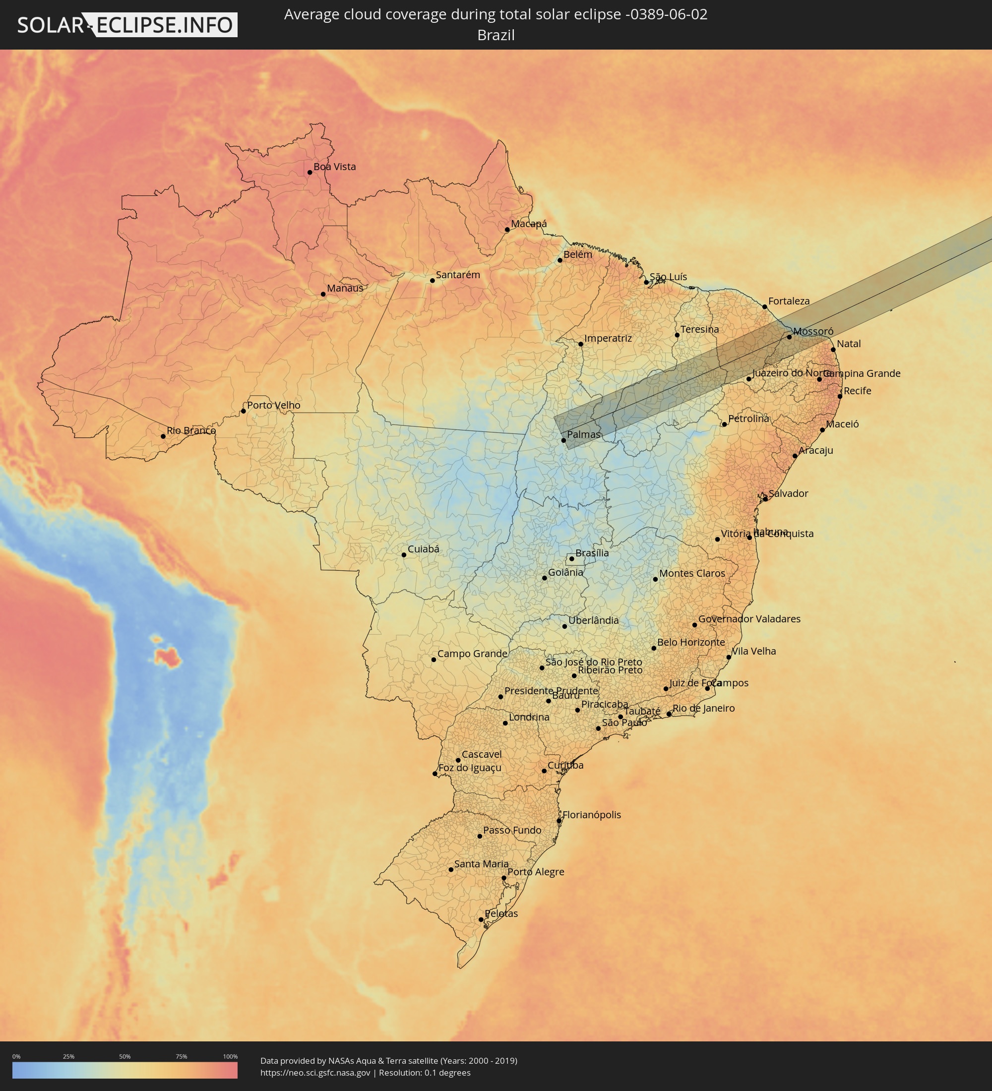 Brazil
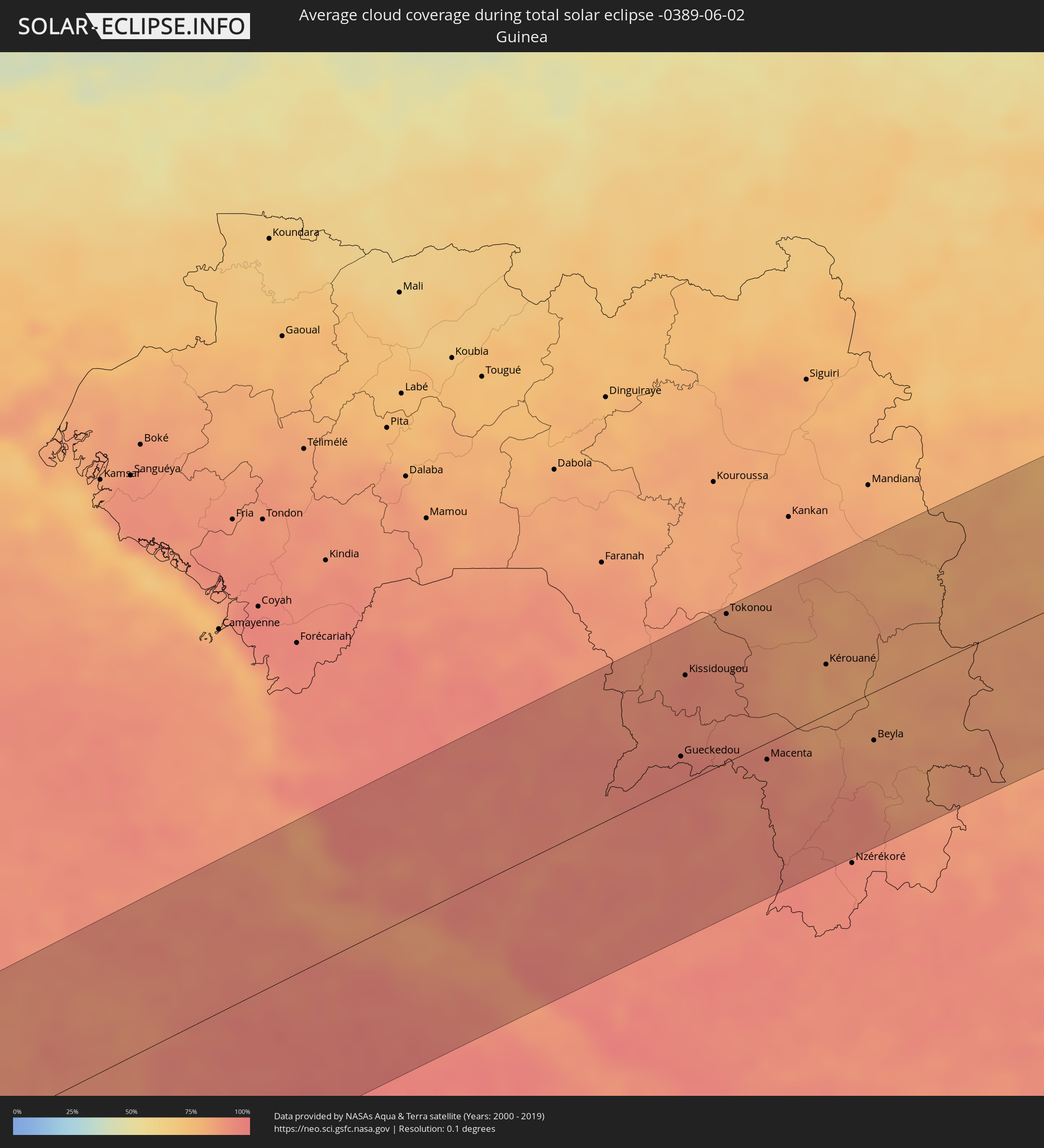 Guinea
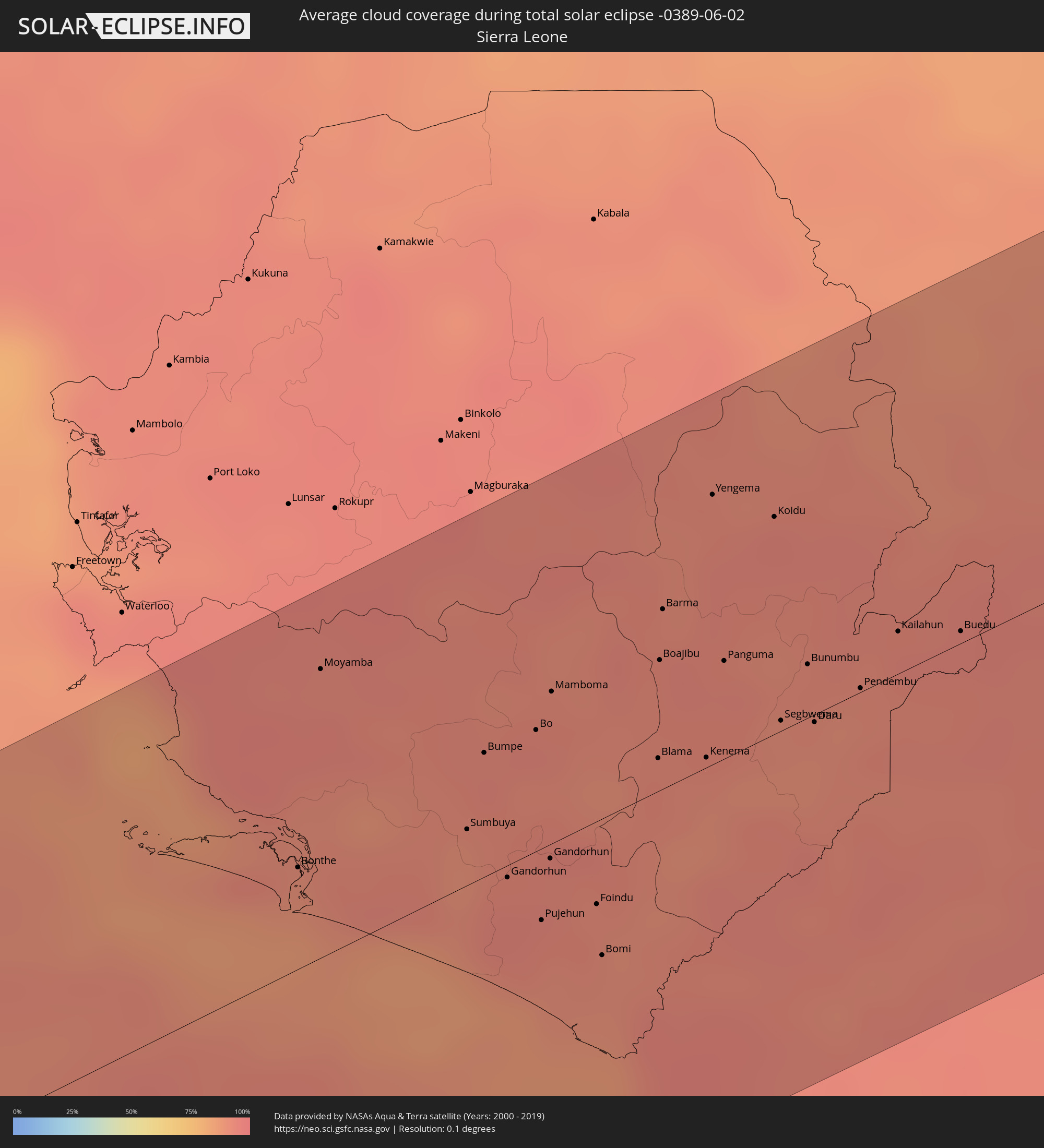 Sierra Leone
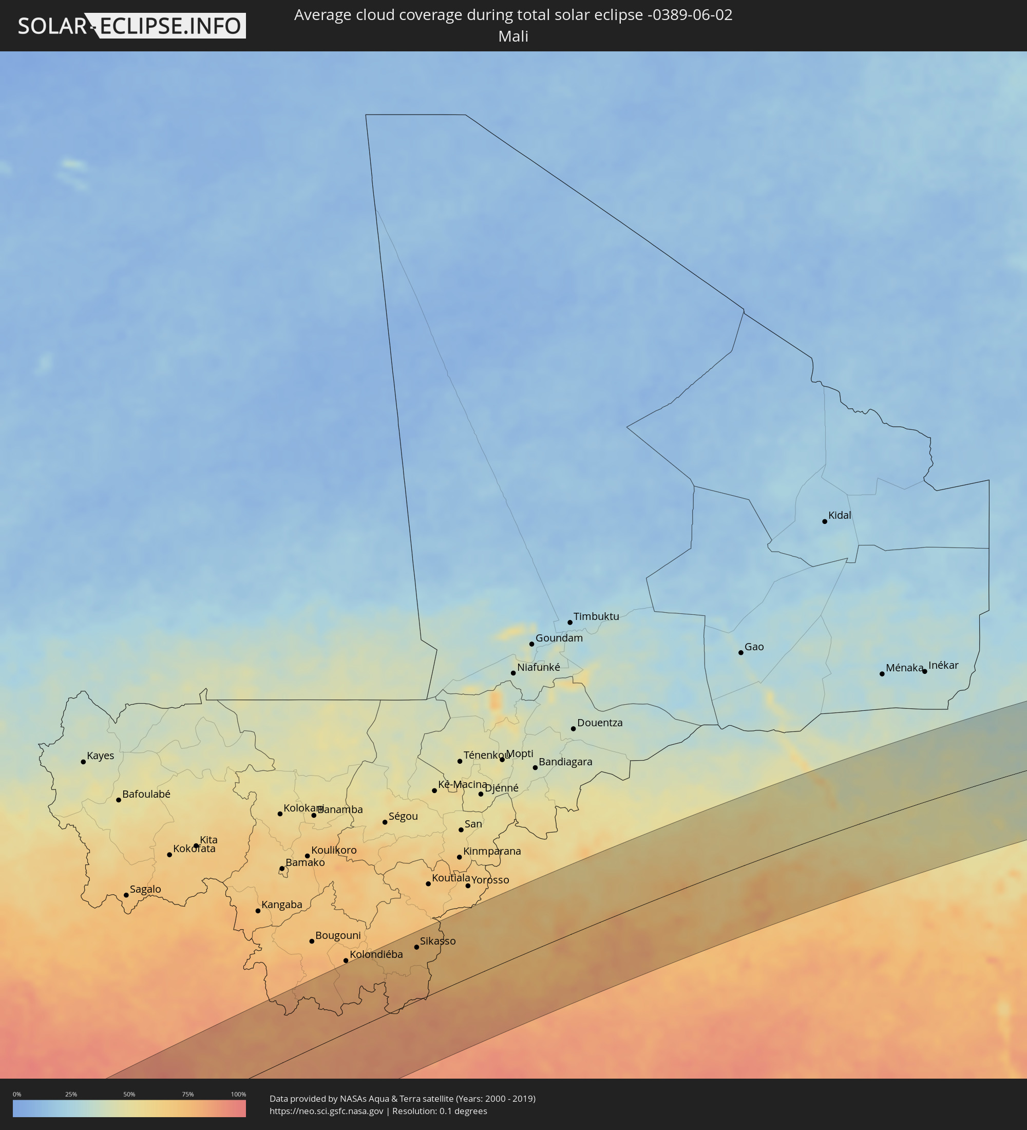 Mali
Mali
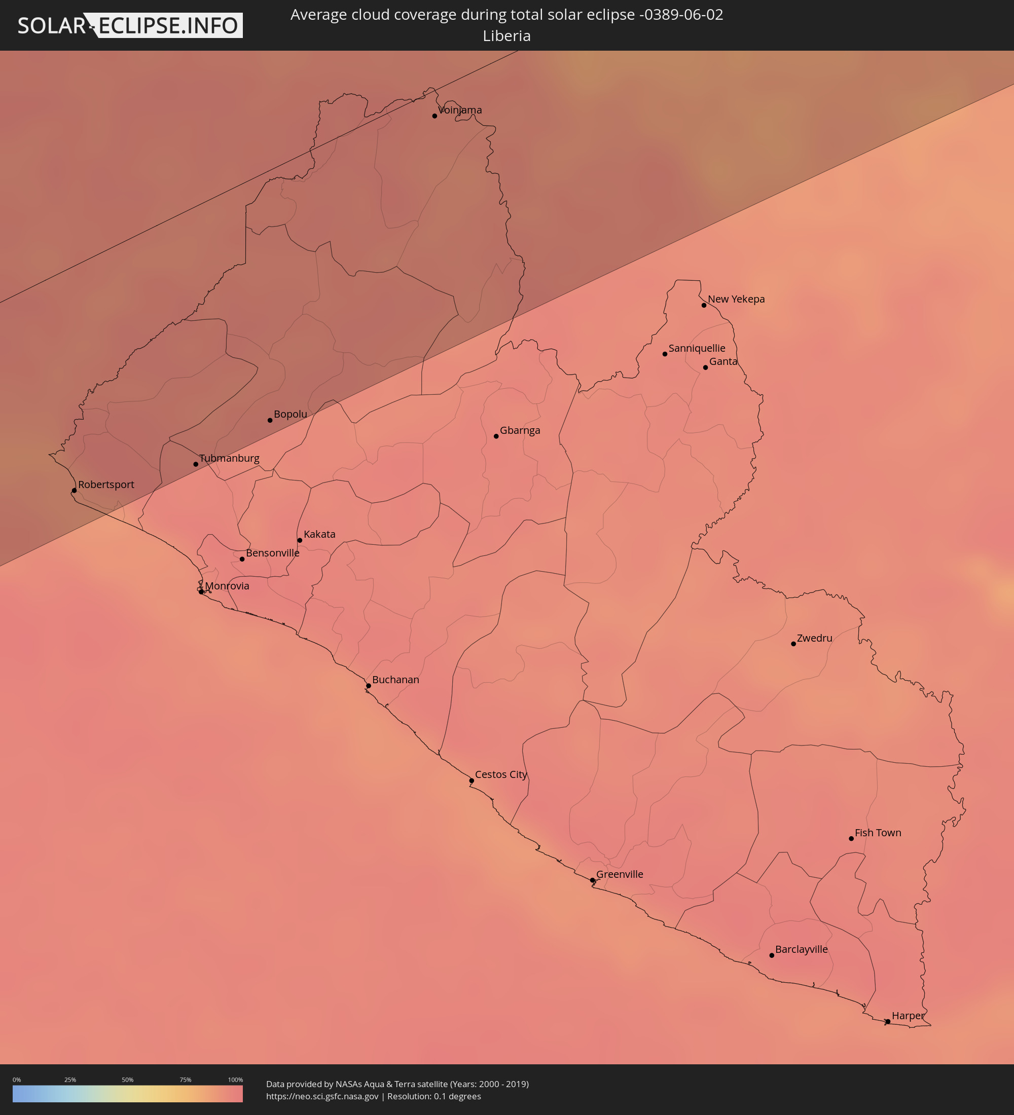 Liberia
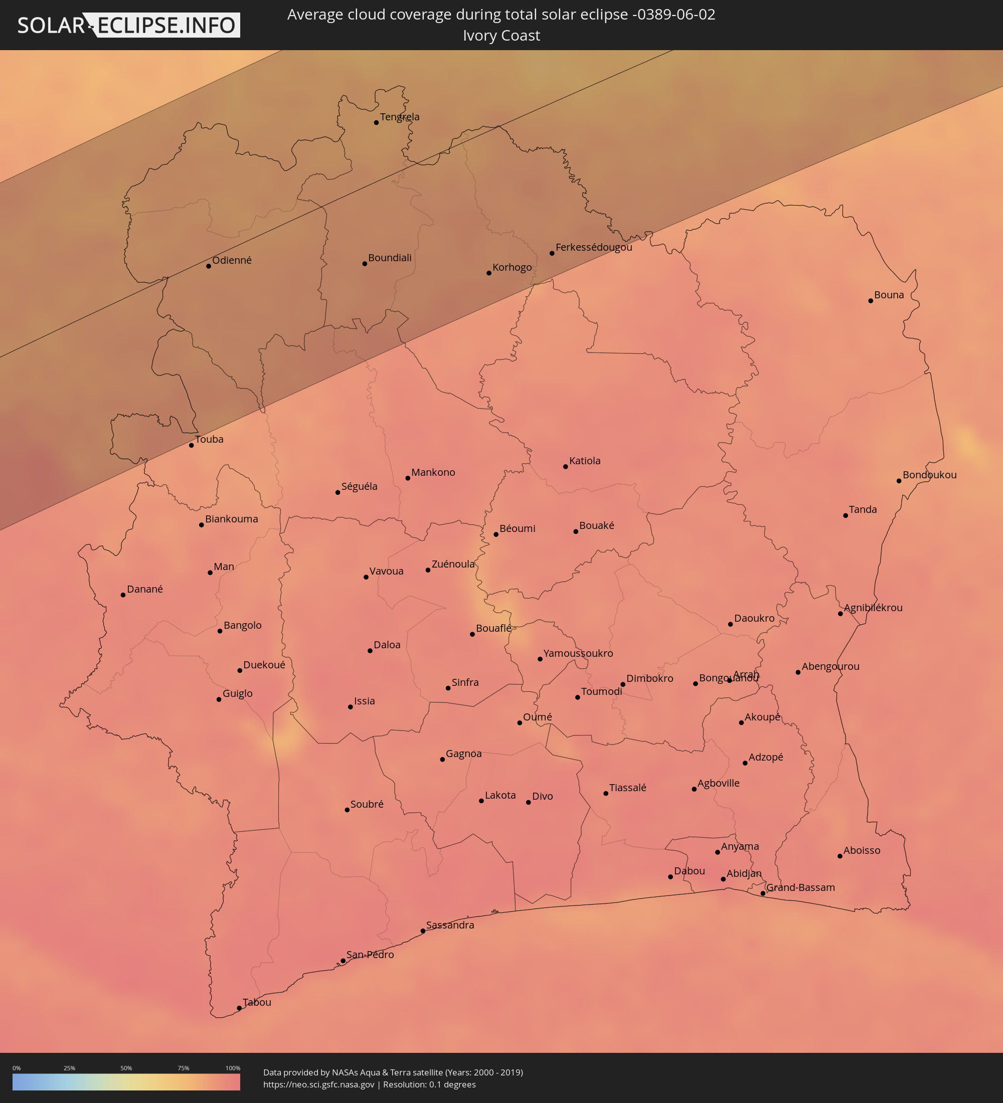 Ivory Coast
 Burkina Faso
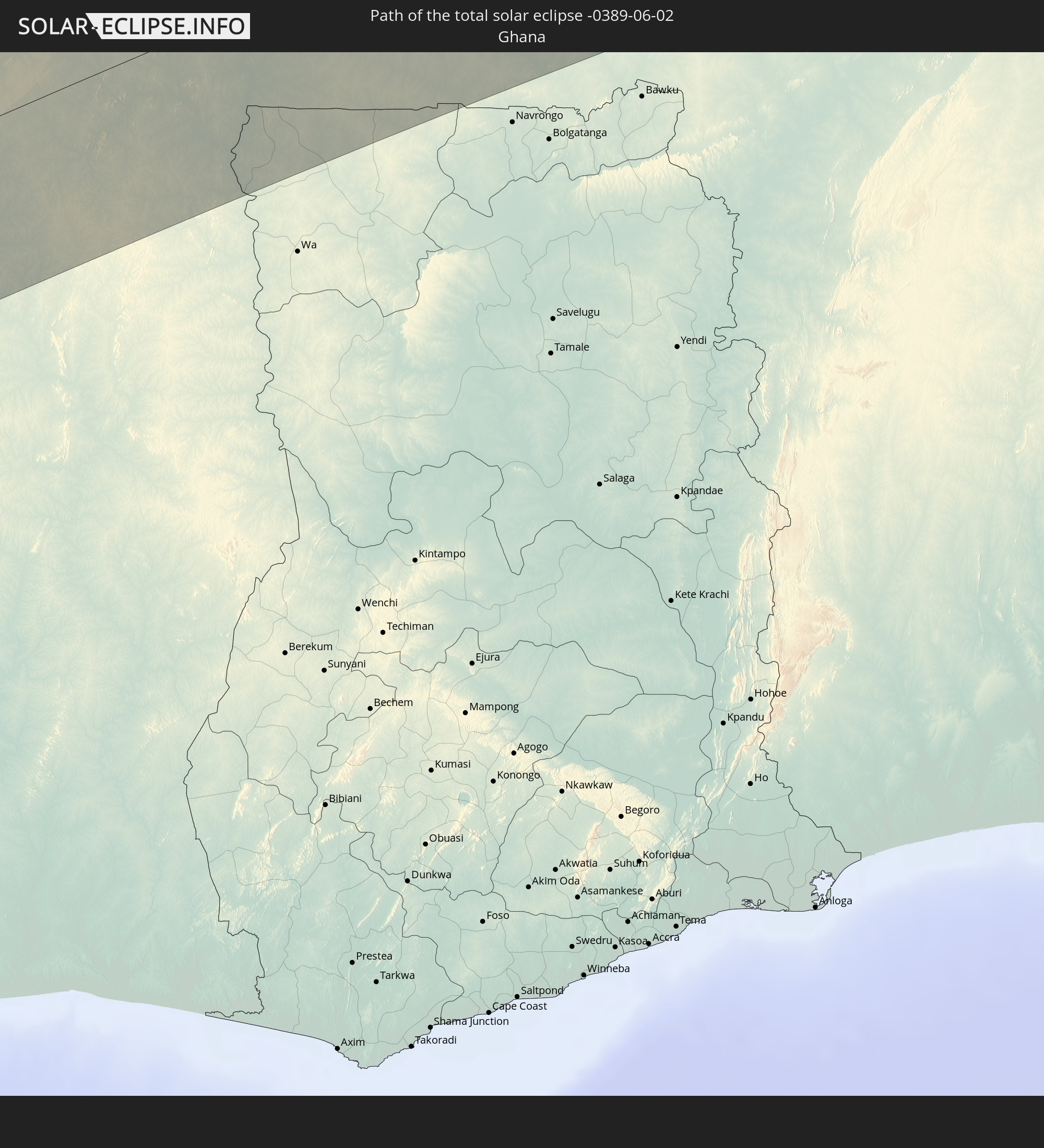
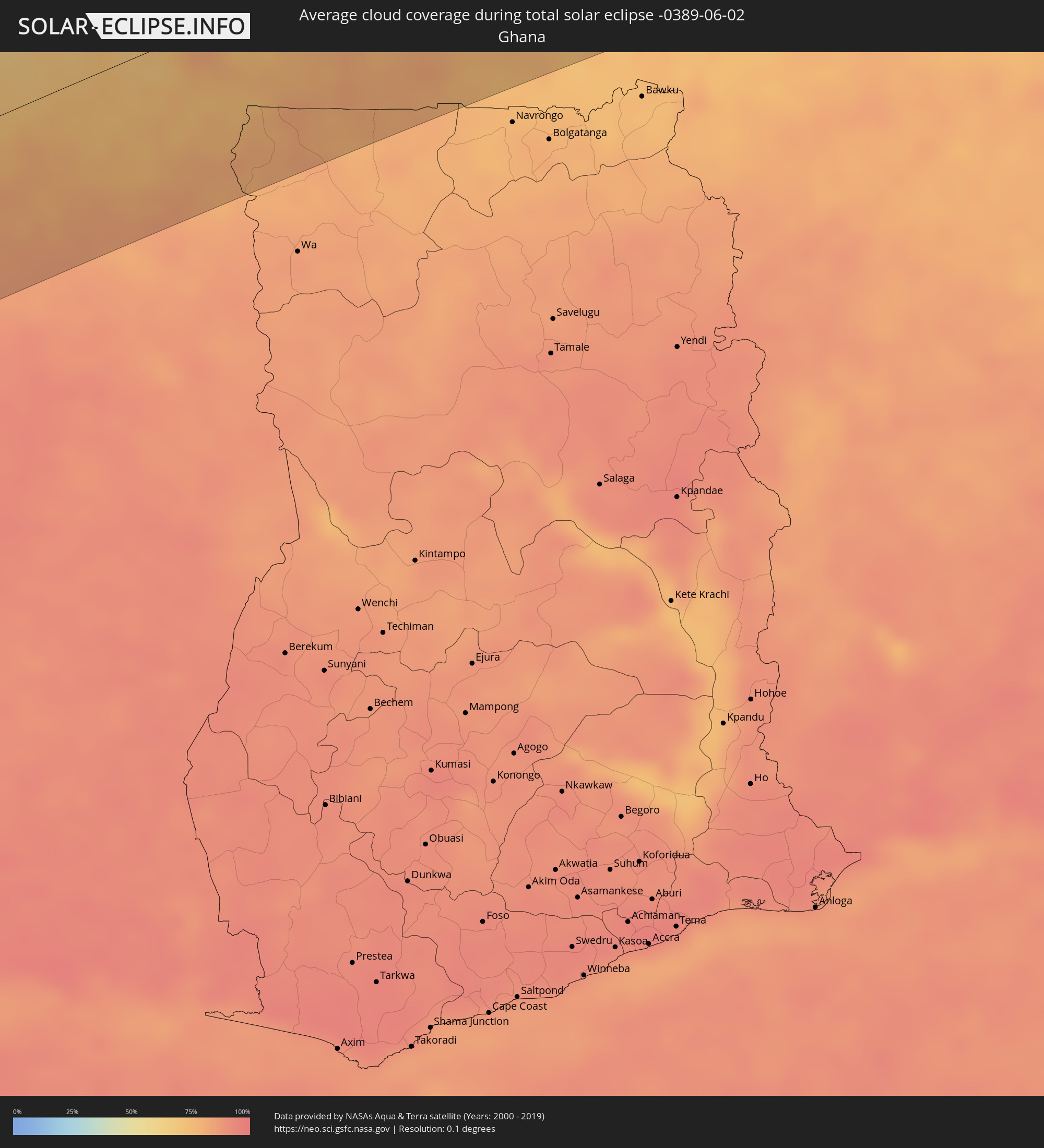 Ghana
Ghana
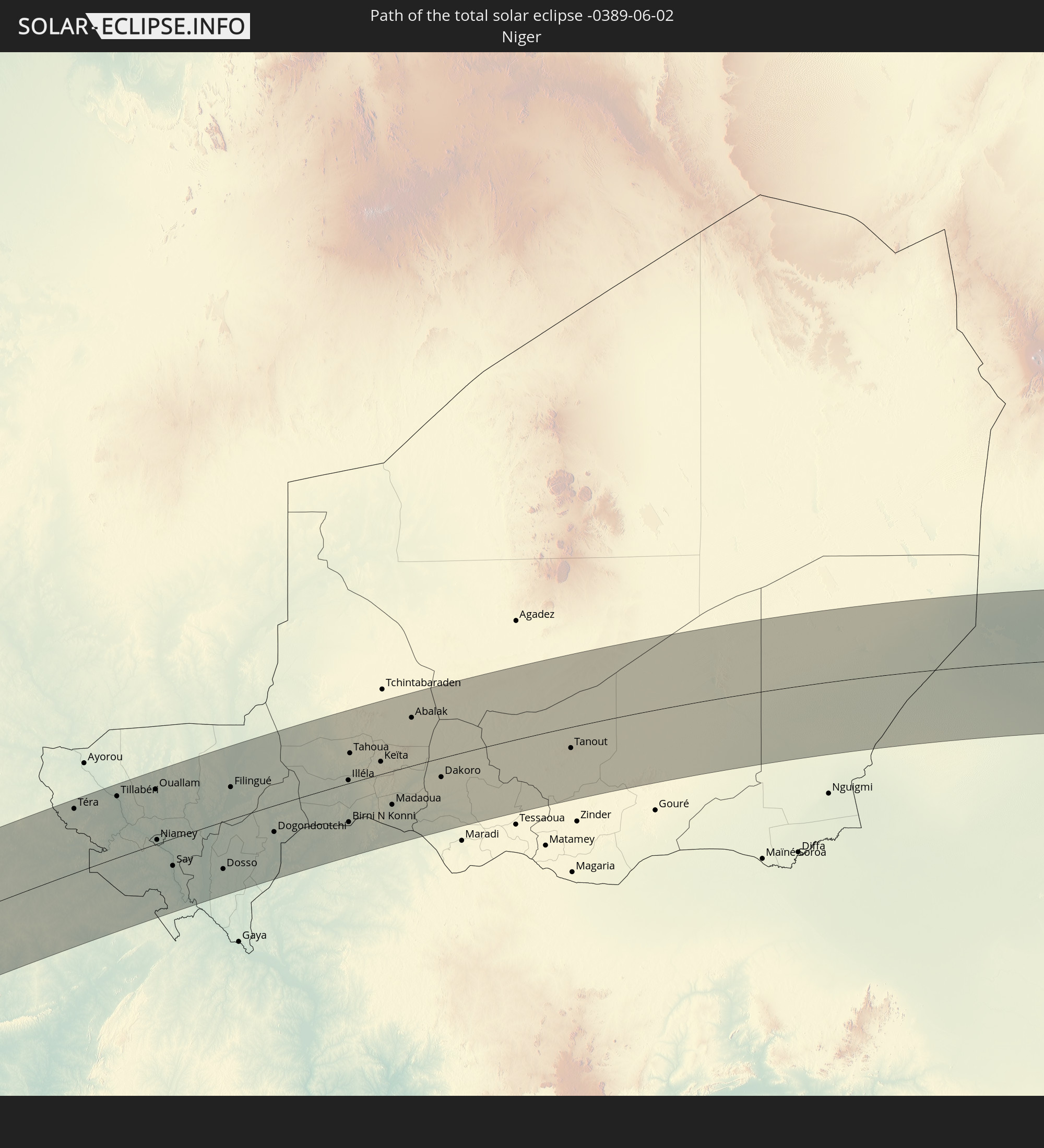
 Niger
Niger
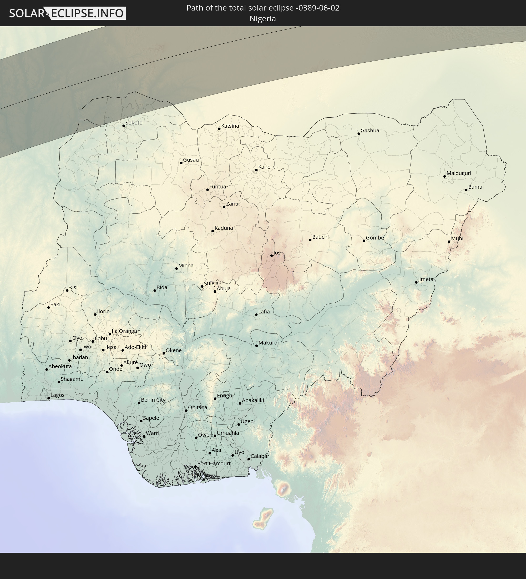
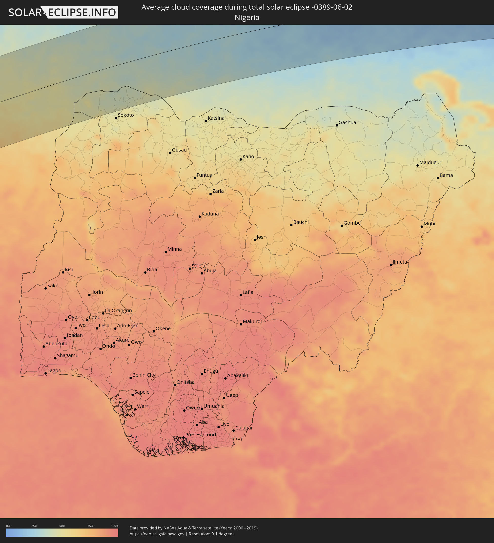 Nigeria
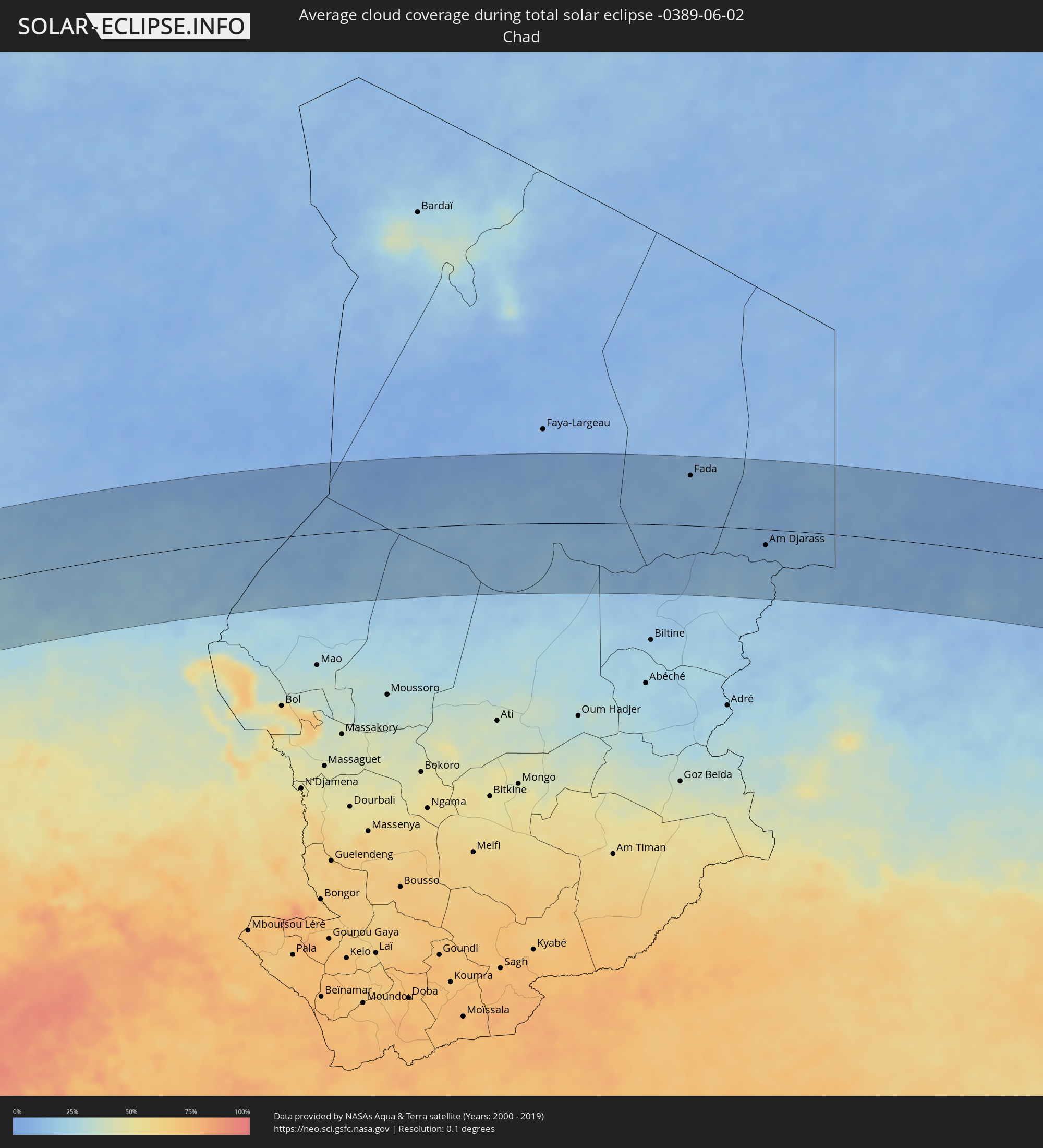 Chad
Chad
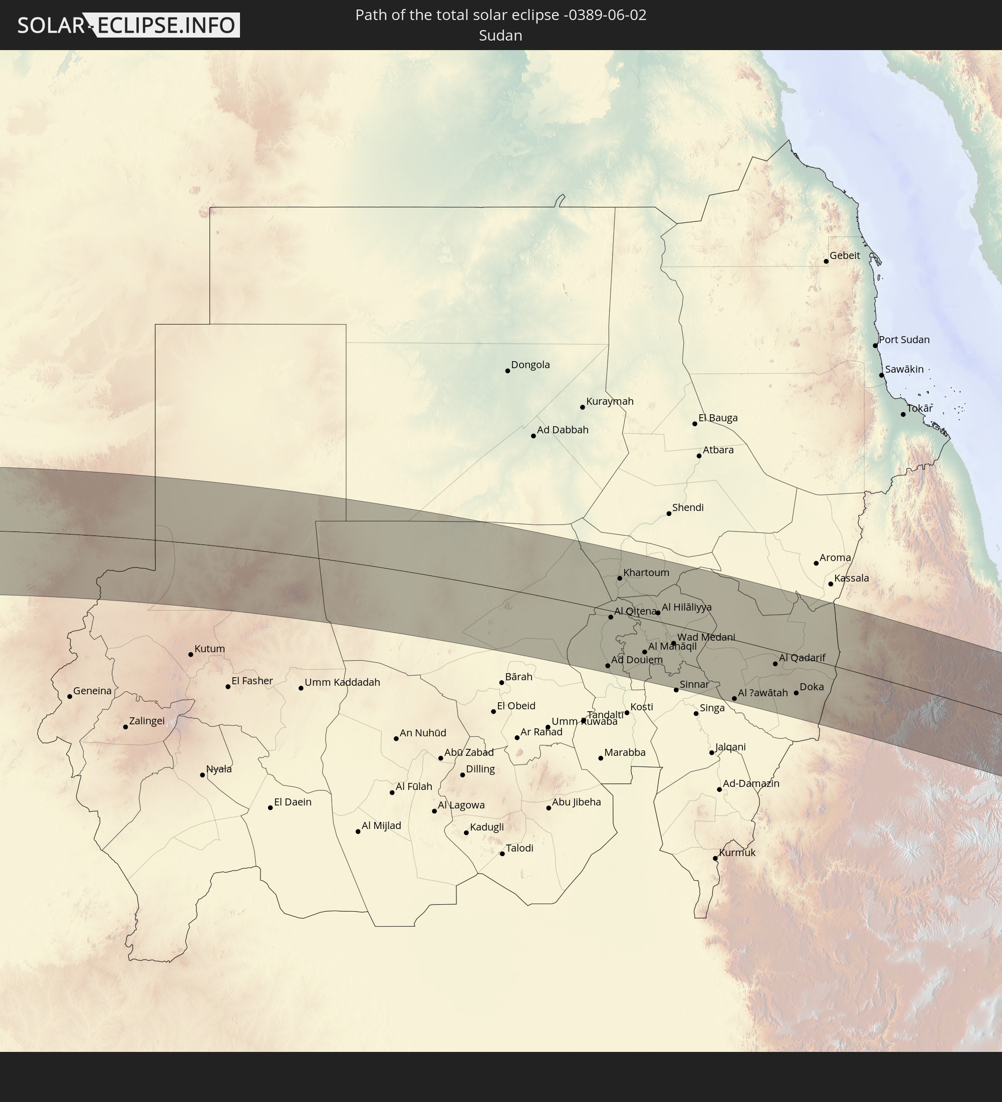
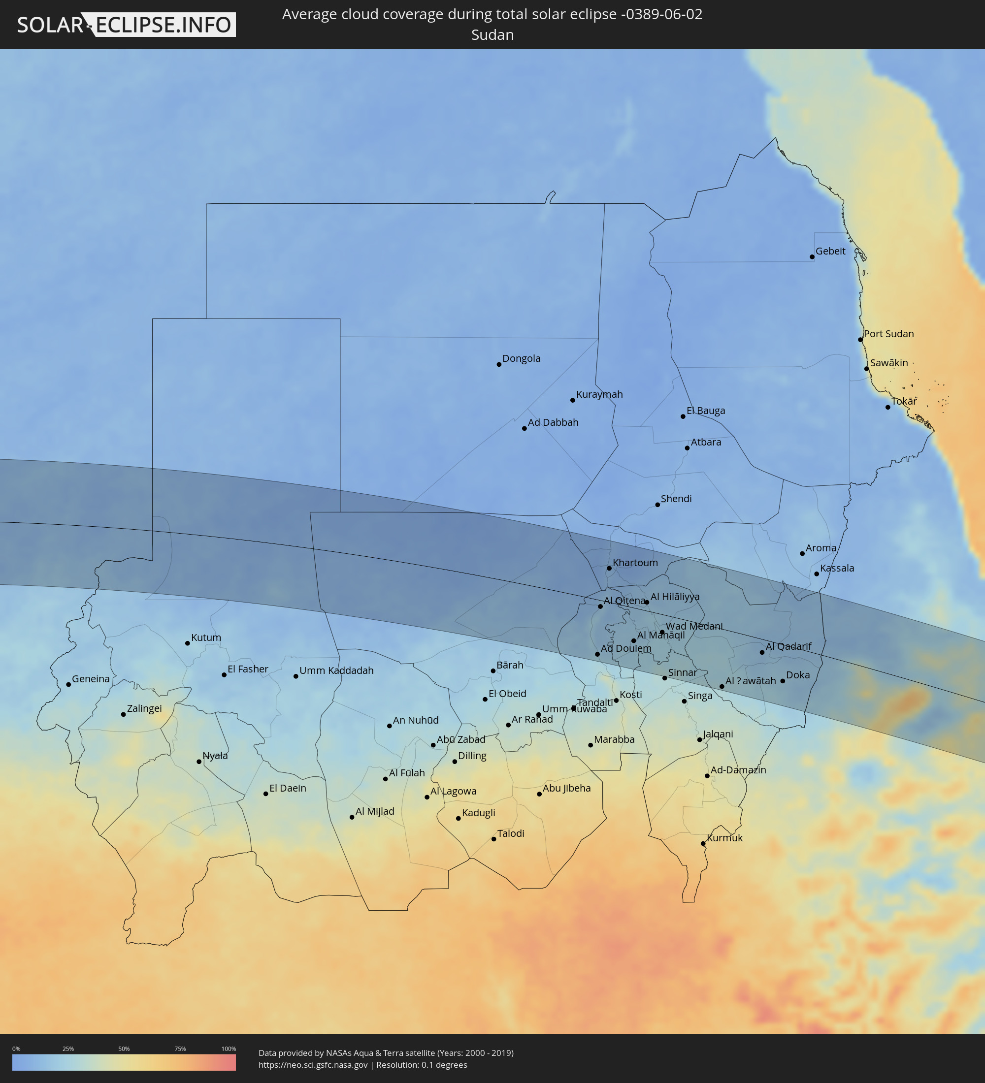 Sudan
Sudan
 Ethiopia
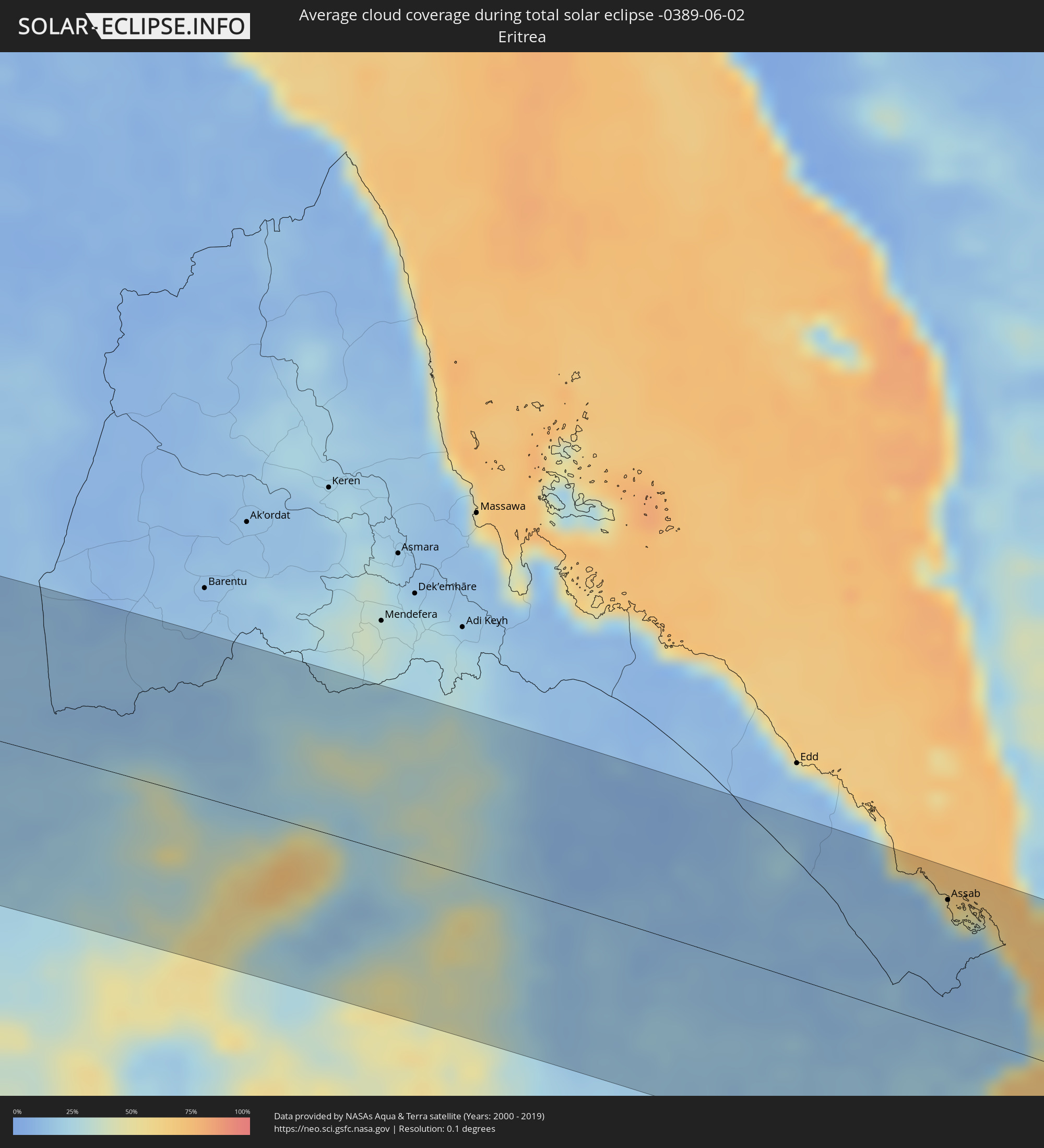 Eritrea
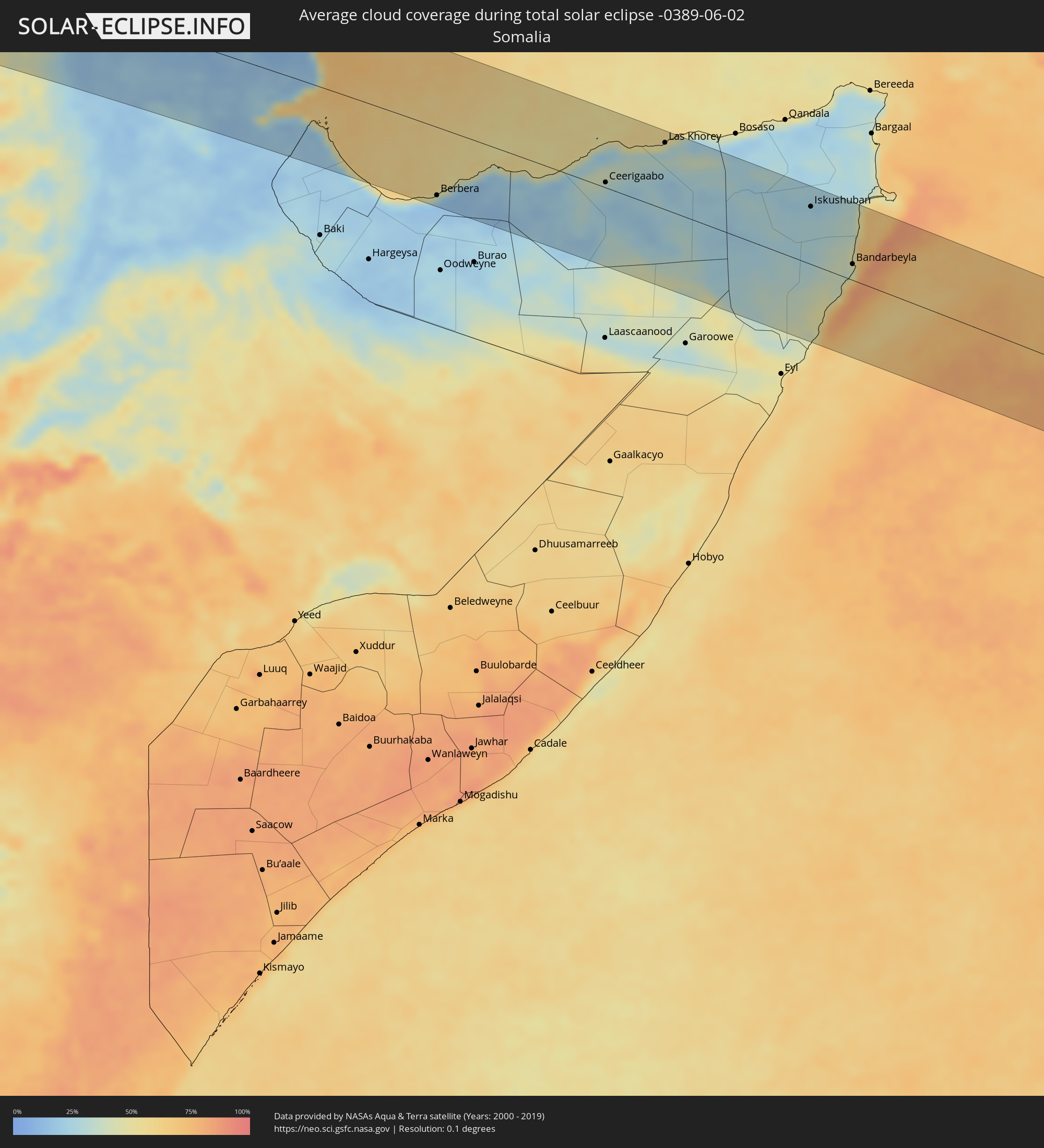 Somalia
 Djibouti
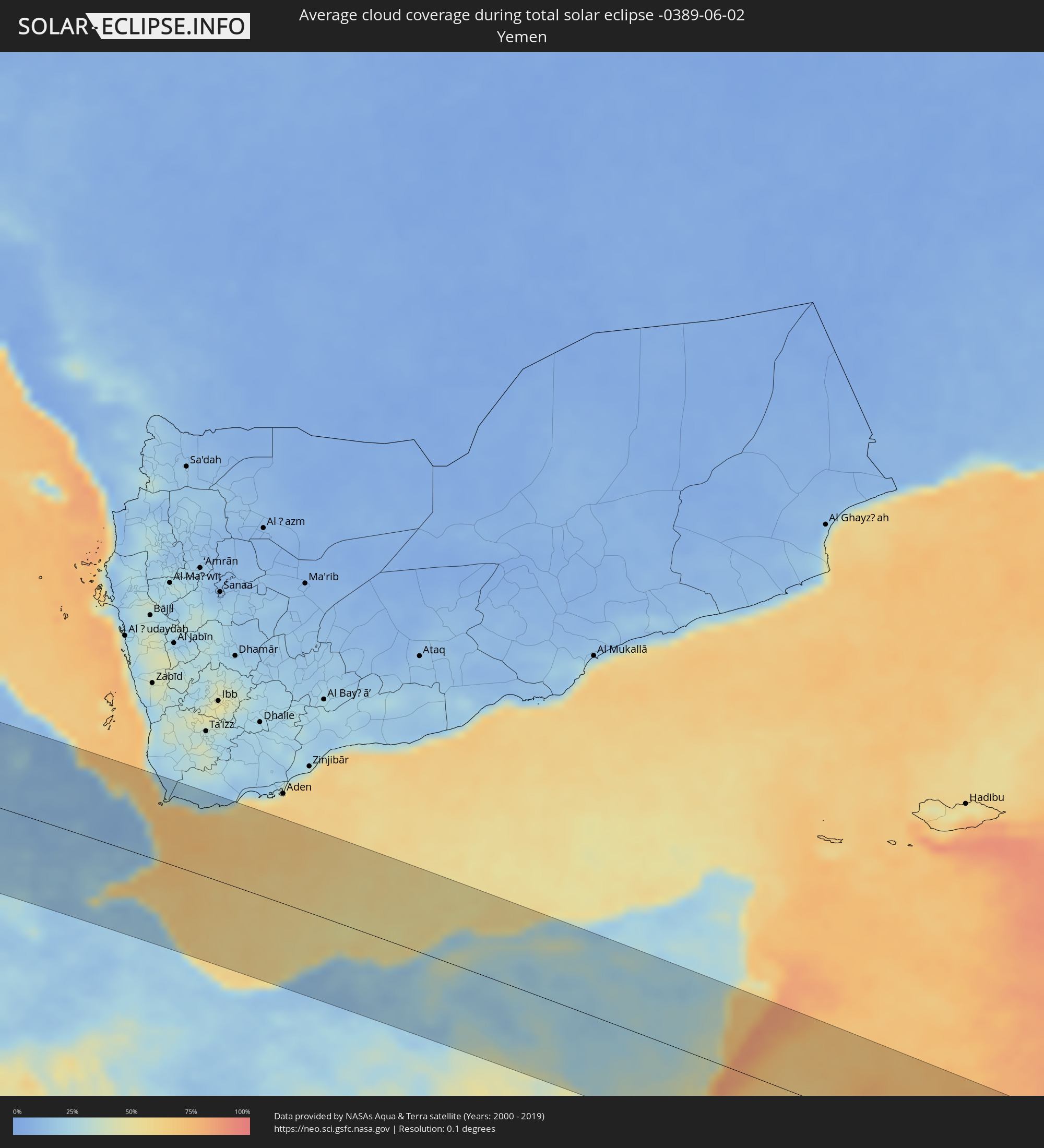 Yemen
Yemen
 Maldives
Cities inside the path of the eclipse
The following table shows all locations with a population of more than 5,000 inside the eclipse path. Cities which have more than 100,000 inhabitants are marked bold. A click at the locations opens a detailed map.
| City | Type | Eclipse duration | Local time of max. eclipse | Distance to central line | Ø Cloud coverage |
|
Floriano, Piauí
|
total | - | 06:48:26 UTC-02:34 | 80 km | 44% |
|
Picos, Piauí
|
total | - | 06:48:36 UTC-02:34 | 20 km | 52% |
|
São João dos Inhamuns, Ceará
|
total | - | 06:49:06 UTC-02:34 | 37 km | 68% |
|
Iguatu, Ceará
|
total | - | 06:49:14 UTC-02:34 | 44 km | 63% |
|
Quixeramobim, Ceará
|
total | - | 06:49:34 UTC-02:34 | 74 km | 69% |
|
Quixadá, Ceará
|
total | - | 06:49:43 UTC-02:34 | 85 km | 72% |
|
Icó, Ceará
|
total | - | 06:49:20 UTC-02:34 | 67 km | 61% |
|
Morada Nova, Ceará
|
total | - | 06:49:51 UTC-02:34 | 42 km | 66% |
|
Limoeiro do Norte, Ceará
|
total | - | 06:49:55 UTC-02:34 | 25 km | 67% |
|
Russas, Ceará
|
total | - | 06:50:02 UTC-02:34 | 40 km | 66% |
|
Aracati, Ceará
|
total | - | 06:50:13 UTC-02:34 | 69 km | 59% |
|
Mossoró, Rio Grande do Norte
|
total | - | 06:50:09 UTC-02:34 | 14 km | 61% |
|
Açu, Rio Grande do Norte
|
total | - | 06:50:10 UTC-02:34 | 73 km | 56% |
|
Bonthe, Southern Province
|
total | - | 09:39:15 UTC-00:16 | 32 km | 88% |
|
Bumpe, Southern Province
|
total | - | 09:40:36 UTC-00:16 | 39 km | 94% |
|
Gandorhun, Southern Province
|
total | - | 09:40:22 UTC-00:16 | 4 km | 94% |
|
Bo, Southern Province
|
total | - | 09:40:57 UTC-00:16 | 39 km | 93% |
|
Gandorhun, Southern Province
|
total | - | 09:40:39 UTC-00:16 | 5 km | 93% |
|
Robertsport, Grand Cape Mount
|
total | - | 09:13:30 UTC-00:43 | 100 km | 88% |
|
Blama, Eastern Province
|
total | - | 09:41:33 UTC-00:16 | 10 km | 92% |
|
Kenema, Eastern Province
|
total | - | 09:41:50 UTC-00:16 | 3 km | 91% |
|
Yengema, Eastern Province
|
total | - | 09:42:39 UTC-00:16 | 86 km | 92% |
|
Panguma, Eastern Province
|
total | - | 09:42:13 UTC-00:16 | 31 km | 93% |
|
Koidu, Eastern Province
|
total | - | 09:42:56 UTC-00:16 | 69 km | 94% |
|
Segbwema, Eastern Province
|
total | - | 09:42:22 UTC-00:16 | 3 km | 91% |
|
Tubmanburg, Bomi
|
total | - | 09:14:34 UTC-00:43 | 115 km | 94% |
|
Pendembu, Eastern Province
|
total | - | 09:42:55 UTC-00:16 | 1 km | 91% |
|
Kailahun, Eastern Province
|
total | - | 09:43:18 UTC-00:16 | 13 km | 94% |
|
Bopolu, Gbarpolu
|
total | - | 09:15:21 UTC-00:43 | 112 km | 93% |
|
Gueckedou, Nzerekore
|
total | - | 09:44:23 UTC-00:16 | 21 km | 94% |
|
Kissidougou, Faranah
|
total | - | 09:45:02 UTC-00:16 | 81 km | 93% |
|
Tokonou, Kankan
|
total | - | 09:46:04 UTC-00:16 | 113 km | 85% |
|
Voinjama, Lofa
|
total | - | 09:17:58 UTC-00:43 | 12 km | 91% |
|
Macenta, Nzerekore
|
total | - | 09:45:36 UTC-00:16 | 13 km | 91% |
|
Kérouané, Kankan
|
total | - | 09:47:09 UTC-00:16 | 38 km | 84% |
|
Beyla, Nzerekore
|
total | - | 09:47:19 UTC-00:16 | 37 km | 84% |
|
Odienné, Denguélé
|
total | - | 09:50:15 UTC-00:16 | 6 km | 84% |
|
Boundiali, Savanes
|
total | - | 09:52:29 UTC-00:16 | 54 km | 85% |
|
Tengrela, Savanes
|
total | - | 09:53:35 UTC-00:16 | 40 km | 77% |
|
Sikasso, Sikasso
|
total | - | 09:55:58 UTC-00:16 | 92 km | 73% |
|
Korhogo, Savanes
|
total | - | 09:54:15 UTC-00:16 | 99 km | 87% |
|
Ferkessédougou, Savanes
|
total | - | 09:55:20 UTC-00:16 | 105 km | 86% |
|
Banfora, Cascades
|
total | - | 09:57:16 UTC-00:16 | 18 km | 80% |
|
Bobo-Dioulasso, Hauts-Bassins
|
total | - | 09:58:51 UTC-00:16 | 17 km | 70% |
|
Houndé, Hauts-Bassins
|
total | - | 10:00:57 UTC-00:16 | 17 km | 71% |
|
Dédougou, Boucle du Mouhoun
|
total | - | 10:02:00 UTC-00:16 | 113 km | 62% |
|
Koudougou, Centre-Ouest
|
total | - | 10:04:22 UTC-00:16 | 46 km | 63% |
|
Léo, Centre-Ouest
|
total | - | 10:03:54 UTC-00:16 | 83 km | 81% |
|
Ouagadougou, Centre
|
total | - | 10:06:29 UTC-00:16 | 24 km | 70% |
|
Kombissiri, Centre-Sud
|
total | - | 10:06:41 UTC-00:16 | 16 km | 70% |
|
Kaya, Centre-Nord
|
total | - | 10:08:16 UTC-00:16 | 81 km | 59% |
|
Garango, Centre-Est
|
total | - | 10:08:23 UTC-00:16 | 74 km | 71% |
|
Tenkodogo, Centre-Est
|
total | - | 10:08:49 UTC-00:16 | 83 km | 70% |
|
Koupéla, Centre-Est
|
total | - | 10:09:14 UTC-00:16 | 42 km | 65% |
|
Fada N'gourma, Est
|
total | - | 10:10:57 UTC-00:16 | 82 km | 80% |
|
Téra, Tillabéri
|
total | - | 10:43:27 UTC+00:13 | 107 km | 49% |
|
Tillabéri, Tillabéri
|
total | - | 10:45:26 UTC+00:13 | 103 km | 54% |
|
Niamey, Niamey
|
total | - | 10:46:33 UTC+00:13 | 6 km | 53% |
|
Dosso, Dosso
|
total | - | 10:49:05 UTC+00:13 | 80 km | 51% |
|
Dogondoutchi, Dosso
|
total | - | 10:51:52 UTC+00:13 | 45 km | 47% |
|
Binji, Sokoto
|
total | - | 10:54:01 UTC+00:13 | 117 km | 47% |
|
Gwadabawa, Sokoto
|
total | - | 10:55:03 UTC+00:13 | 113 km | 44% |
|
Illéla, Tahoua
|
total | - | 10:55:56 UTC+00:13 | 5 km | 37% |
|
Birni N Konni, Tahoua
|
total | - | 10:55:26 UTC+00:13 | 66 km | 40% |
|
Tahoua, Tahoua
|
total | - | 10:56:20 UTC+00:13 | 50 km | 32% |
|
Illela, Sokoto
|
total | - | 10:55:31 UTC+00:13 | 75 km | 41% |
|
Goronyo, Sokoto
|
total | - | 10:56:22 UTC+00:13 | 117 km | 46% |
|
Madaoua, Tahoua
|
total | - | 10:57:40 UTC+00:13 | 57 km | 40% |
|
Abalak, Tahoua
|
total | - | 10:59:37 UTC+00:13 | 82 km | 28% |
|
Dakoro, Maradi
|
total | - | 11:00:19 UTC+00:13 | 33 km | 32% |
|
Mayahi, Maradi
|
total | - | 11:02:35 UTC+00:13 | 117 km | 37% |
|
Tanout, Zinder
|
total | - | 11:06:51 UTC+00:13 | 36 km | 22% |
|
Fada, Ennedi-Ouest
|
total | - | 12:31:54 UTC+01:00 | 89 km | 13% |
|
Am Djarass, Ennedi-Est
|
total | - | 12:35:32 UTC+01:00 | 28 km | 11% |
|
Ad Douiem, White Nile
|
total | - | 14:10:23 UTC+02:10 | 108 km | 25% |
|
Al Qiţena, White Nile
|
total | - | 14:10:09 UTC+02:10 | 13 km | 18% |
|
Khartoum, Khartoum
|
total | - | 14:10:13 UTC+02:10 | 66 km | 12% |
|
Al Kiremit al ‘Arakiyyīn, Al Jazīrah
|
total | - | 14:11:40 UTC+02:10 | 56 km | 19% |
|
Al Manāqil, Al Jazīrah
|
total | - | 14:11:48 UTC+02:10 | 65 km | 21% |
|
Wad Rāwah, Al Jazīrah
|
total | - | 14:11:44 UTC+02:10 | 37 km | 15% |
|
Kināna, Sinnār
|
total | - | 14:12:18 UTC+02:10 | 84 km | 24% |
|
Al Hilāliyya, Al Jazīrah
|
total | - | 14:12:02 UTC+02:10 | 16 km | 19% |
|
Al Hasaheisa, Al Jazīrah
|
total | - | 14:12:16 UTC+02:10 | 3 km | 23% |
|
Wad Medani, Al Jazīrah
|
total | - | 14:12:54 UTC+02:10 | 36 km | 24% |
|
Al Ḩawātah, Al Qaḑārif
|
total | - | 14:15:45 UTC+02:10 | 113 km | 28% |
|
Al Qadarif, Al Qaḑārif
|
total | - | 14:17:01 UTC+02:10 | 27 km | 16% |
|
Doka, Al Qaḑārif
|
total | - | 14:18:03 UTC+02:10 | 72 km | 20% |
|
Dabat, Amhara
|
total | - | 14:39:22 UTC+02:27 | 71 km | 56% |
|
Debark’, Amhara
|
total | - | 14:39:32 UTC+02:27 | 49 km | 60% |
|
Inda Silasē, Tigray
|
total | - | 14:39:45 UTC+02:27 | 64 km | 34% |
|
Axum, Tigray
|
total | - | 14:40:33 UTC+02:27 | 79 km | 35% |
|
Mekele, Tigray
|
total | - | 14:42:13 UTC+02:27 | 36 km | 31% |
|
Korem, Tigray
|
total | - | 14:42:50 UTC+02:27 | 68 km | 40% |
|
Maych’ew, Tigray
|
total | - | 14:42:43 UTC+02:27 | 37 km | 44% |
|
Robīt, Amhara
|
total | - | 14:43:16 UTC+02:27 | 116 km | 37% |
|
Semera, Āfar
|
total | - | 14:45:45 UTC+02:27 | 95 km | 23% |
|
Dubti, Āfar
|
total | - | 14:45:54 UTC+02:27 | 99 km | 24% |
|
Asaita, Āfar
|
total | - | 14:46:34 UTC+02:27 | 104 km | 28% |
|
'Ali Sabieh, Ali Sabieh
|
total | - | 14:48:49 UTC+02:27 | 105 km | 19% |
|
Assab, Southern Red Sea
|
total | - | 14:47:52 UTC+02:27 | 92 km | 21% |
|
‘Arta, Arta
|
total | - | 14:48:50 UTC+02:27 | 61 km | 18% |
|
Tadjoura, Tadjourah
|
total | - | 14:48:45 UTC+02:27 | 32 km | 57% |
|
Ḏânan, Ali Sabieh
|
total | - | 14:49:09 UTC+02:27 | 94 km | 19% |
|
Djibouti, Djibouti
|
total | - | 14:49:16 UTC+02:27 | 44 km | 26% |
|
Obock, Obock
|
total | - | 14:49:17 UTC+02:27 | 1 km | 55% |
|
Berbera, Woqooyi Galbeed
|
total | - | 14:52:35 UTC+02:27 | 98 km | 16% |
|
Ceerigaabo, Sanaag
|
total | - | 14:55:36 UTC+02:27 | 8 km | 28% |
|
Las Khorey, Sanaag
|
total | - | 14:56:20 UTC+02:27 | 96 km | 39% |
|
Iskushuban, Bari
|
total | - | 14:59:06 UTC+02:27 | 82 km | 24% |
|
Bandarbeyla, Bari
|
total | - | 15:00:07 UTC+02:27 | 23 km | 42% |
|
Thinadhoo, Gaafu Dhaalu Atholhu
|
total | - | 17:40:54 UTC+04:54 | 13 km | 71% |
|
Fuvahmulah, Gnyaviyani Atoll
|
total | - | 17:41:03 UTC+04:54 | 55 km | 72% |
|
Viligili, Gaafu Alifu Atholhu
|
total | - | 17:40:53 UTC+04:54 | 55 km | 67% |