Total solar eclipse of 04/30/-0443
| Day of week: | Monday |
| Maximum duration of eclipse: | 07m01s |
| Maximum width of eclipse path: | 264 km |
| Saros cycle: | 60 |
| Coverage: | 100% |
| Magnitude: | 1.0774 |
| Gamma: | -0.3188 |
Wo kann man die Sonnenfinsternis vom 04/30/-0443 sehen?
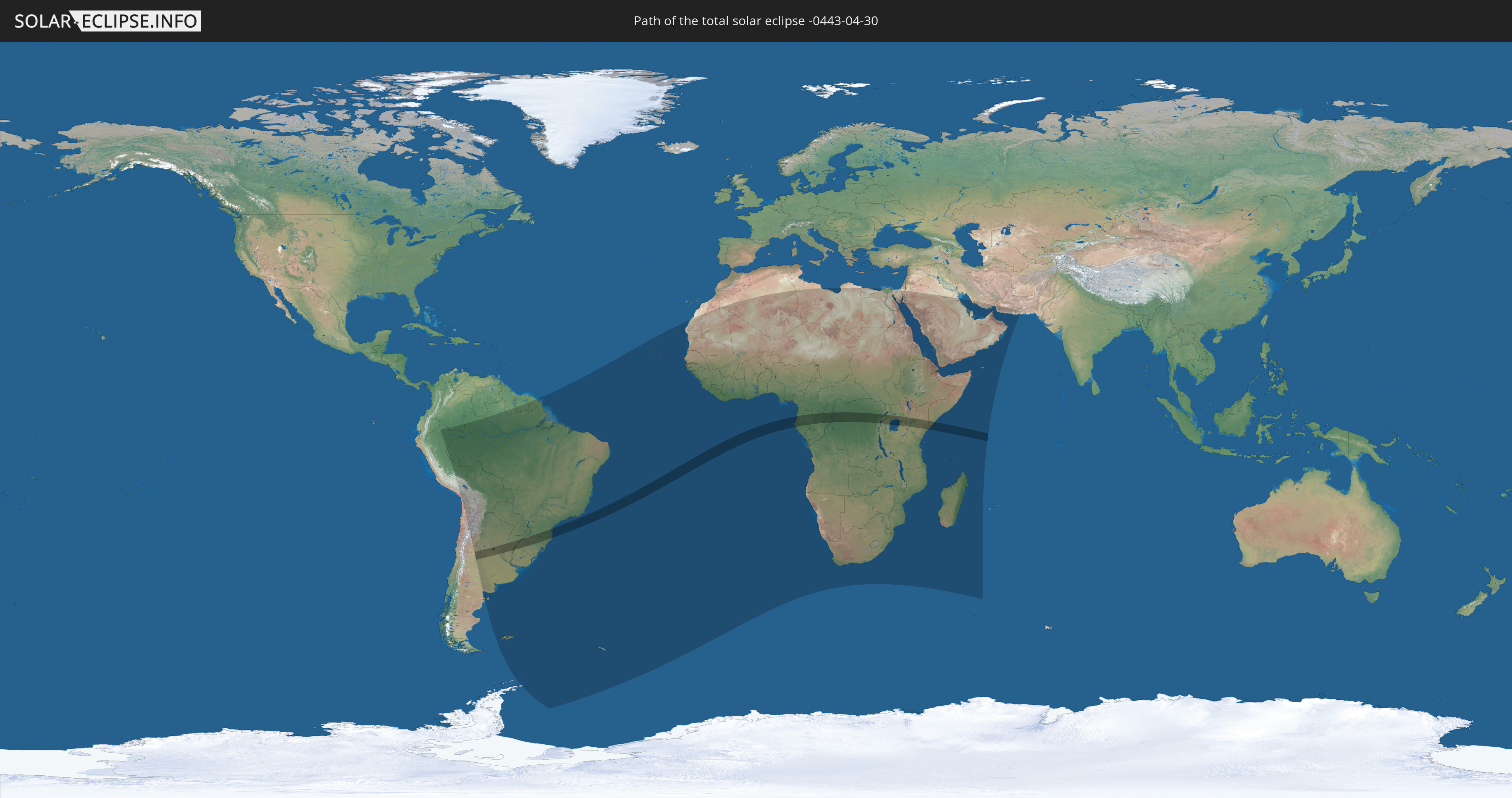
Die Sonnenfinsternis am 04/30/-0443 kann man in 80 Ländern als partielle Sonnenfinsternis beobachten.
Der Finsternispfad verläuft durch 13 Länder. Nur in diesen Ländern ist sie als total Sonnenfinsternis zu sehen.
In den folgenden Ländern ist die Sonnenfinsternis total zu sehen
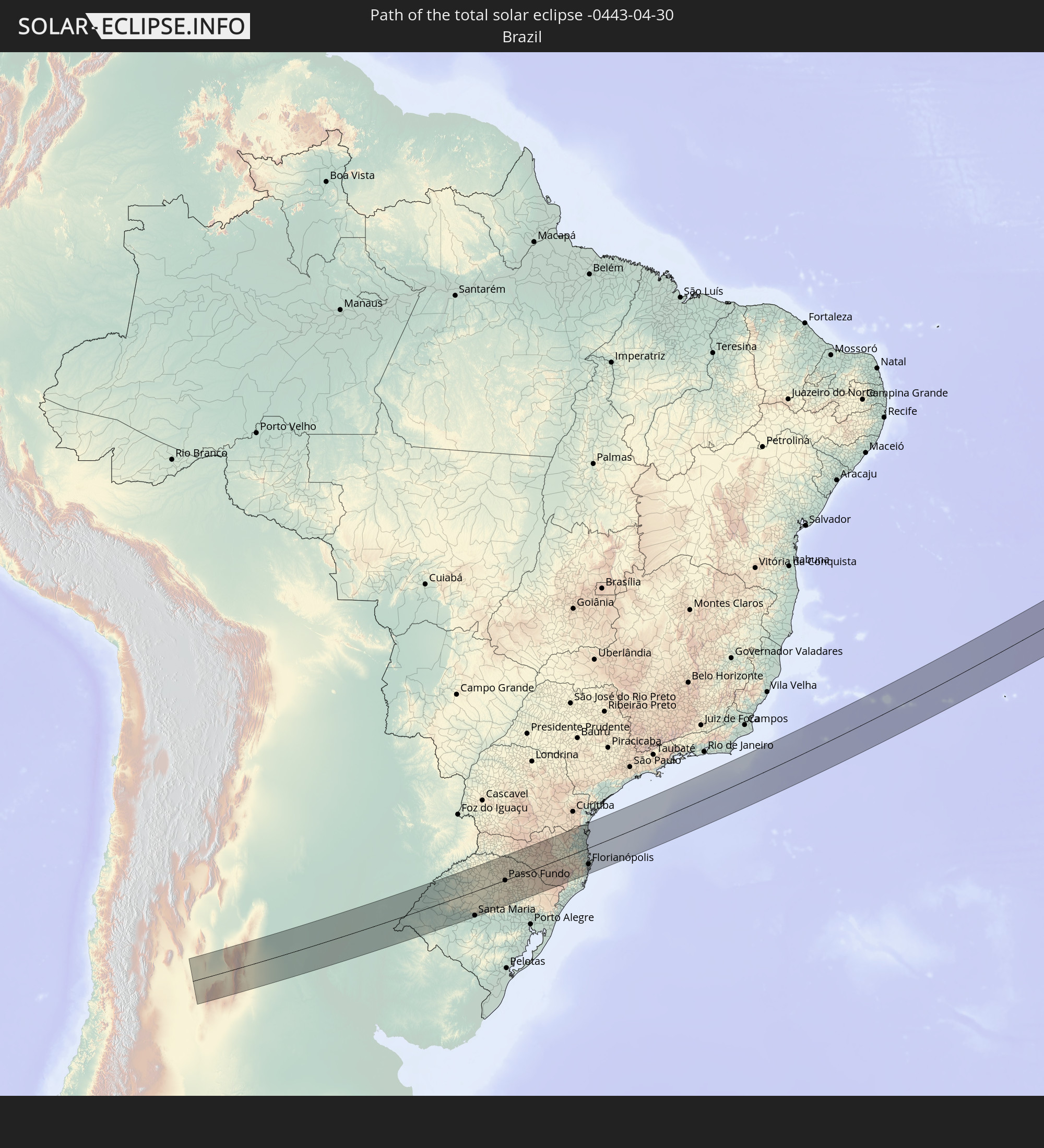 Brazil
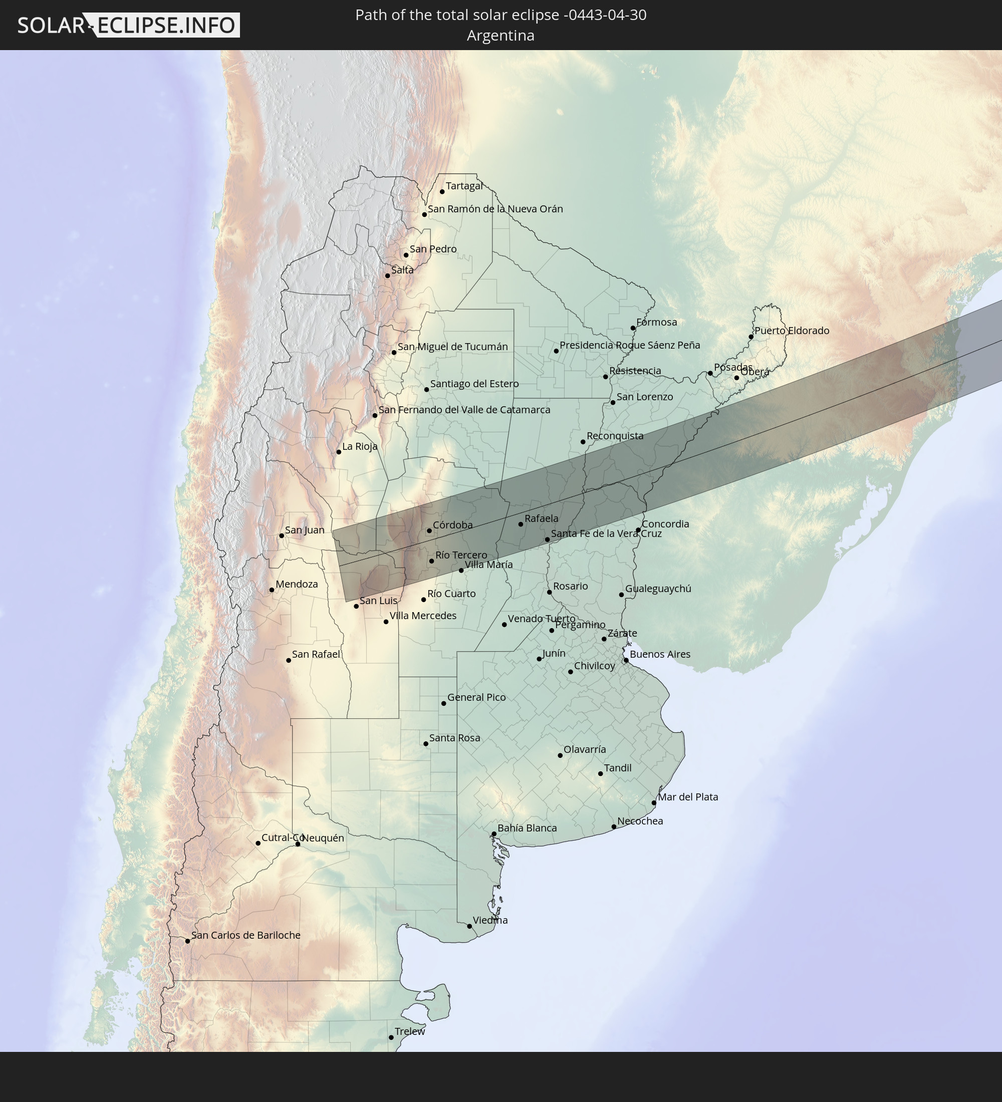 Argentina
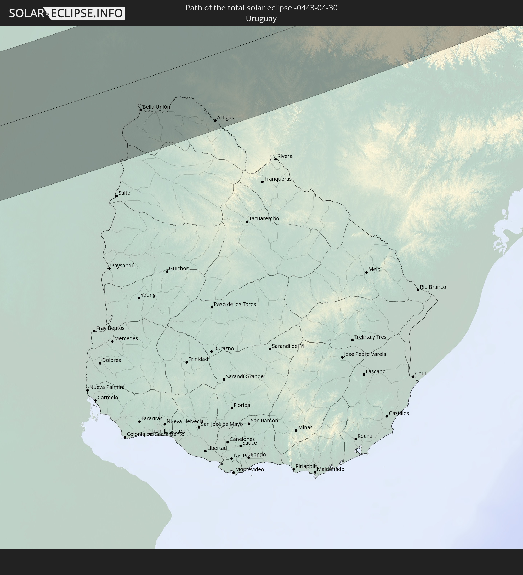 Uruguay
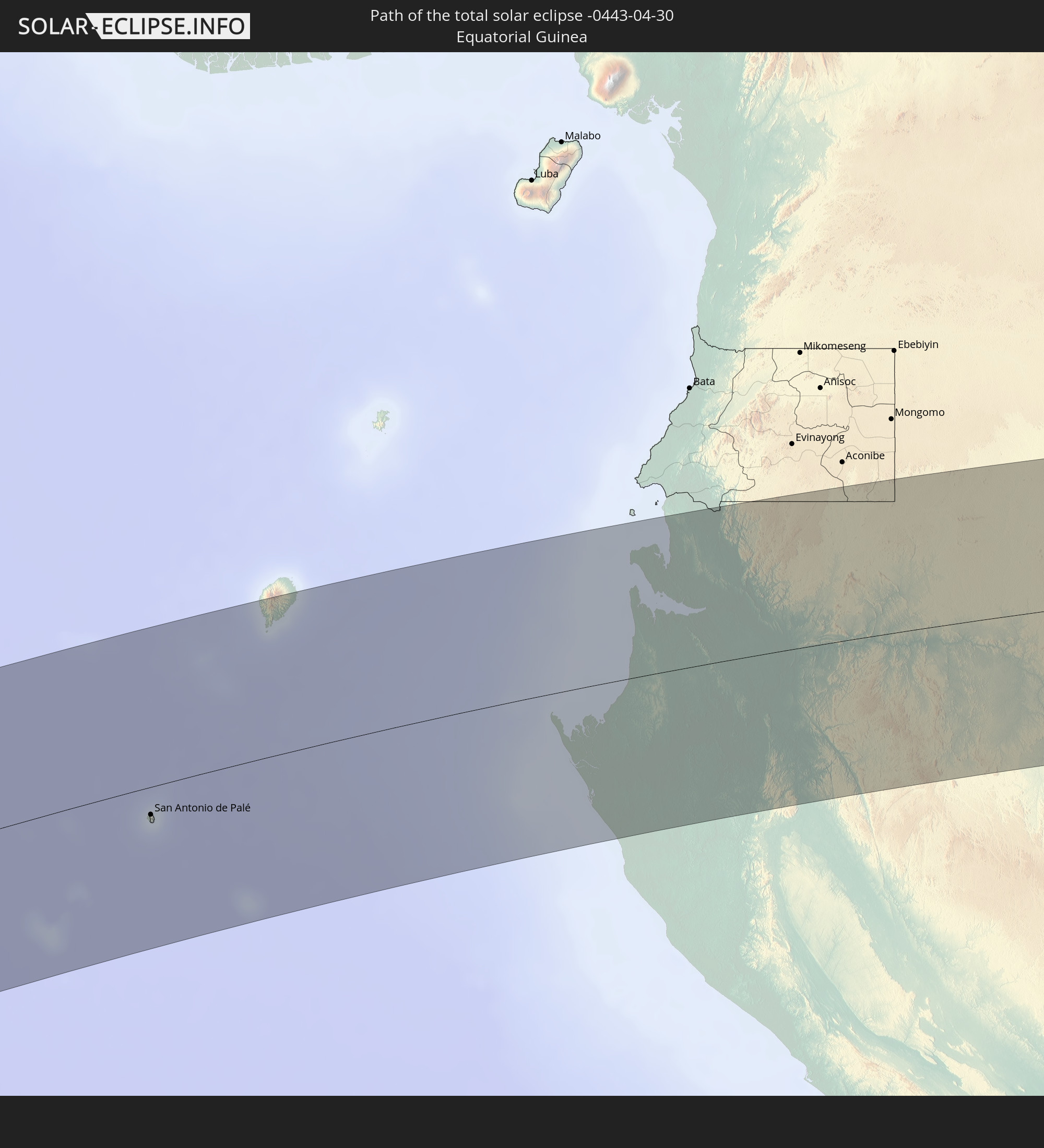 Equatorial Guinea
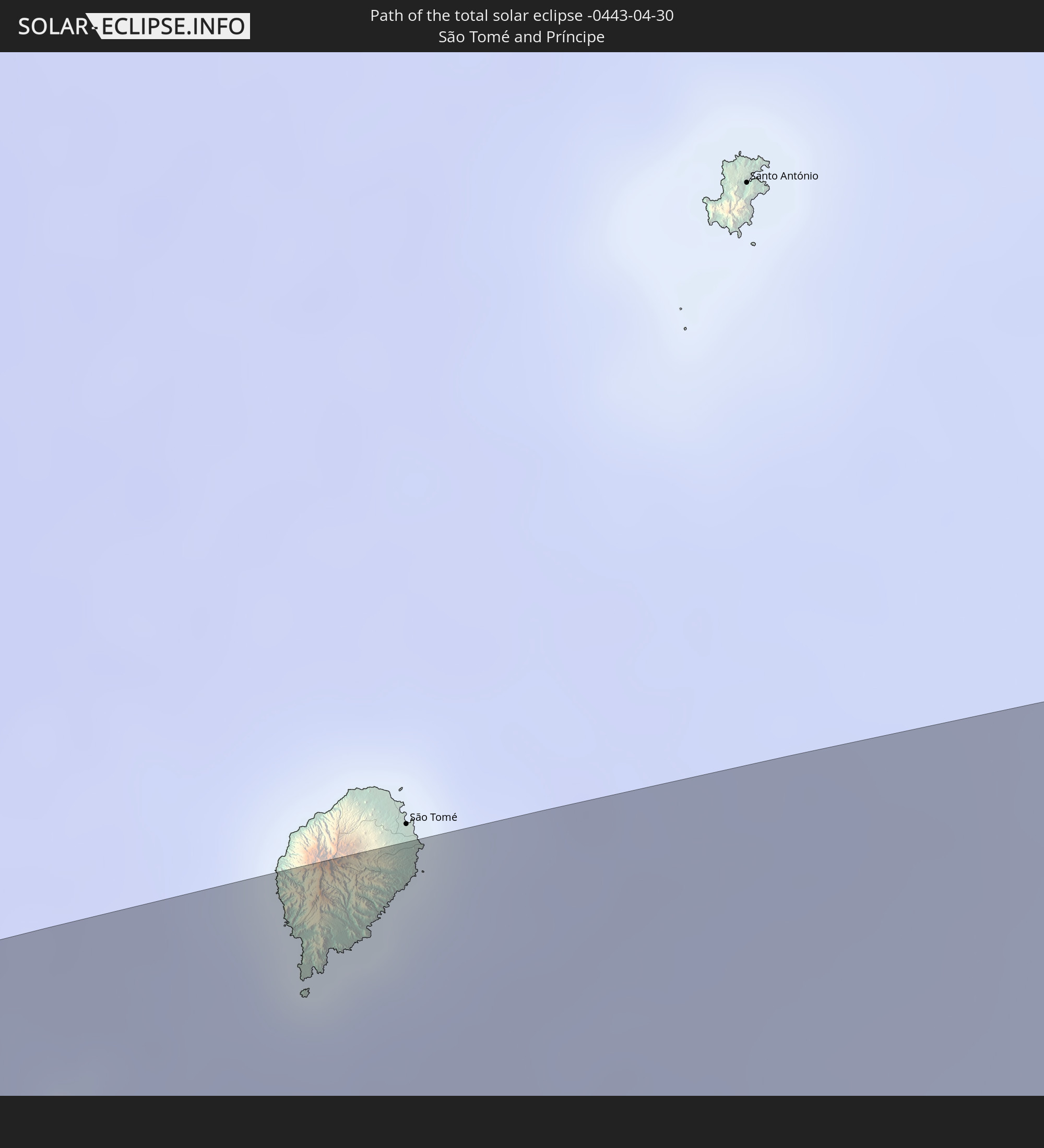 São Tomé and Príncipe
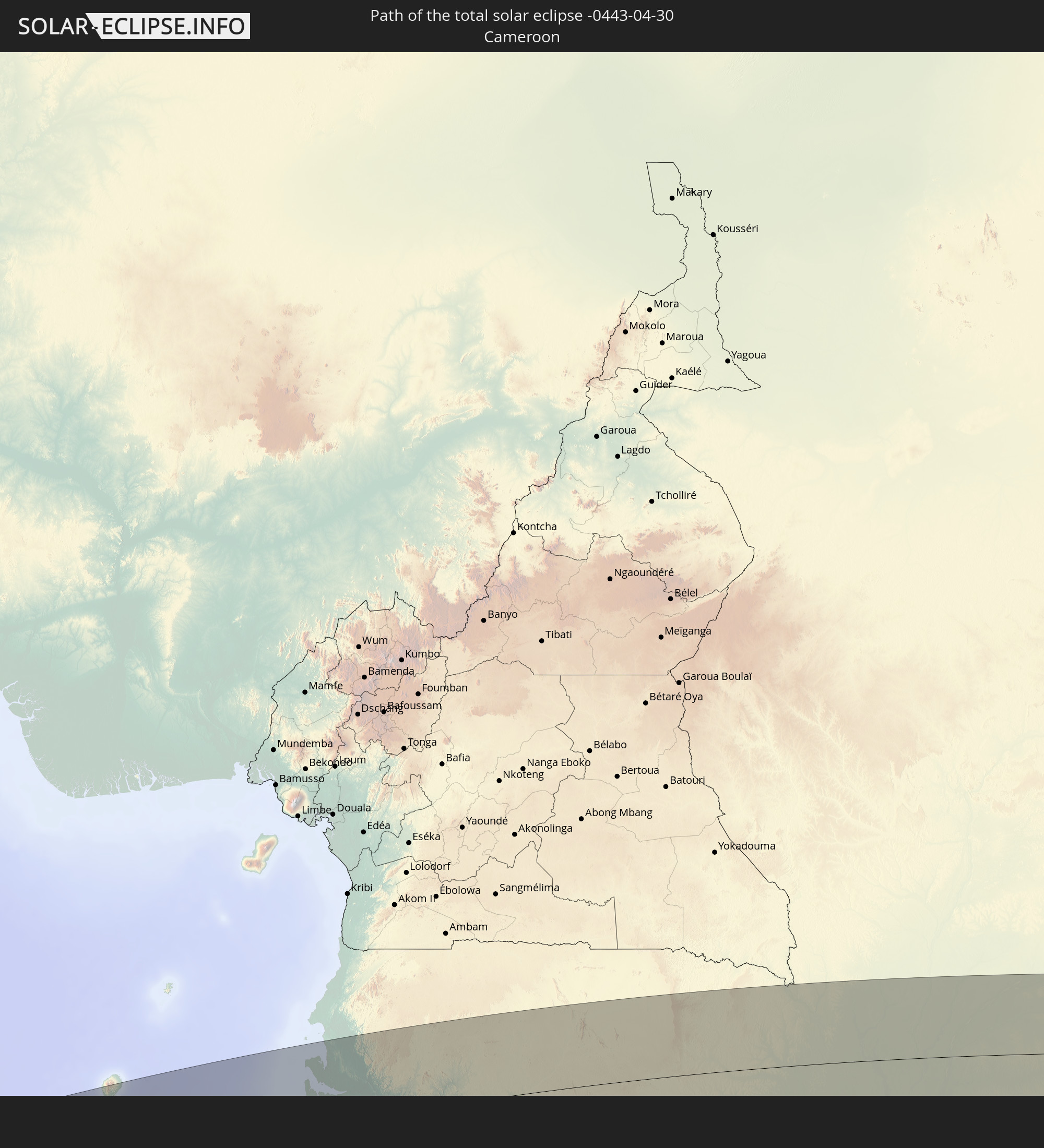 Cameroon
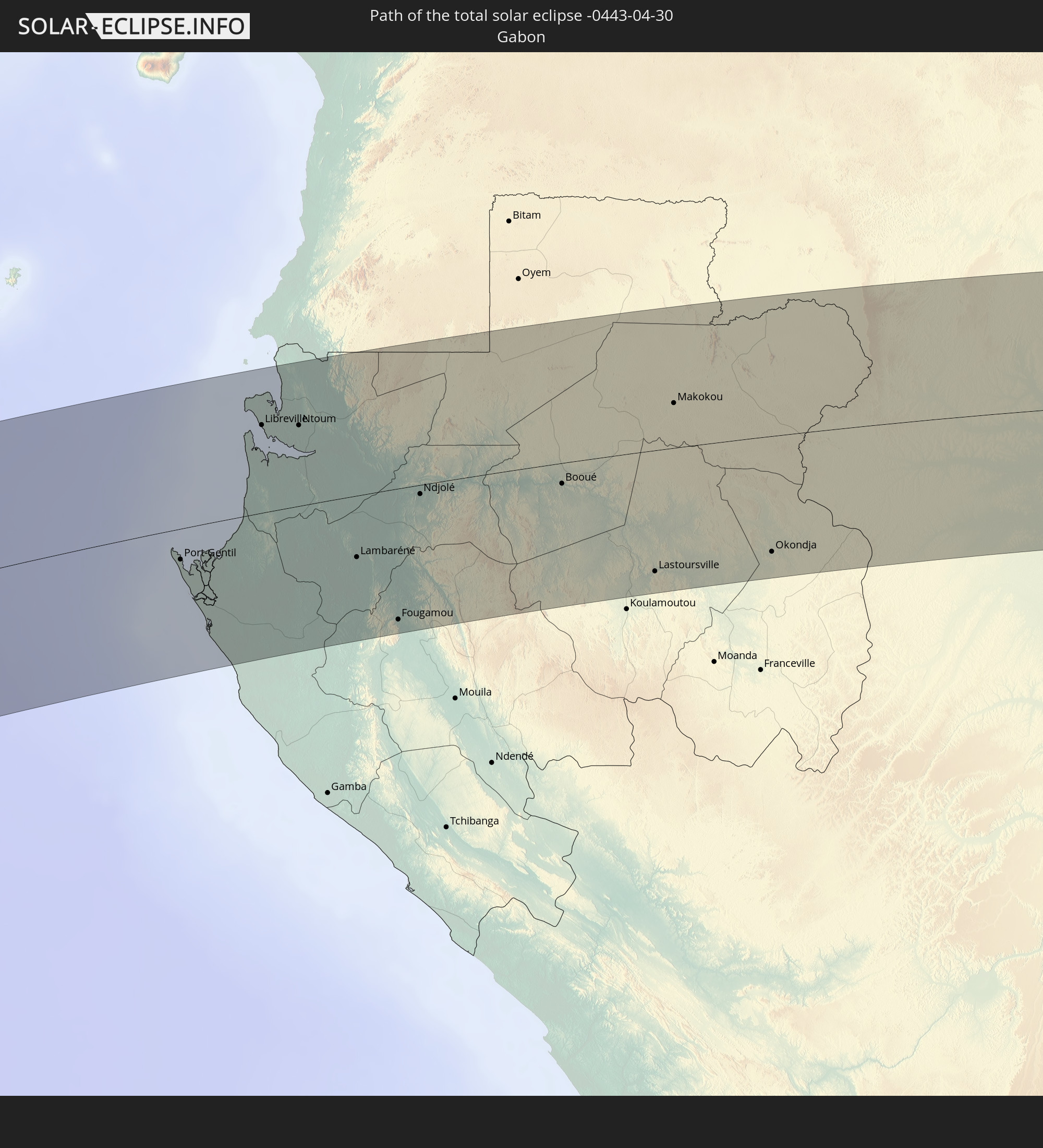 Gabon
Gabon
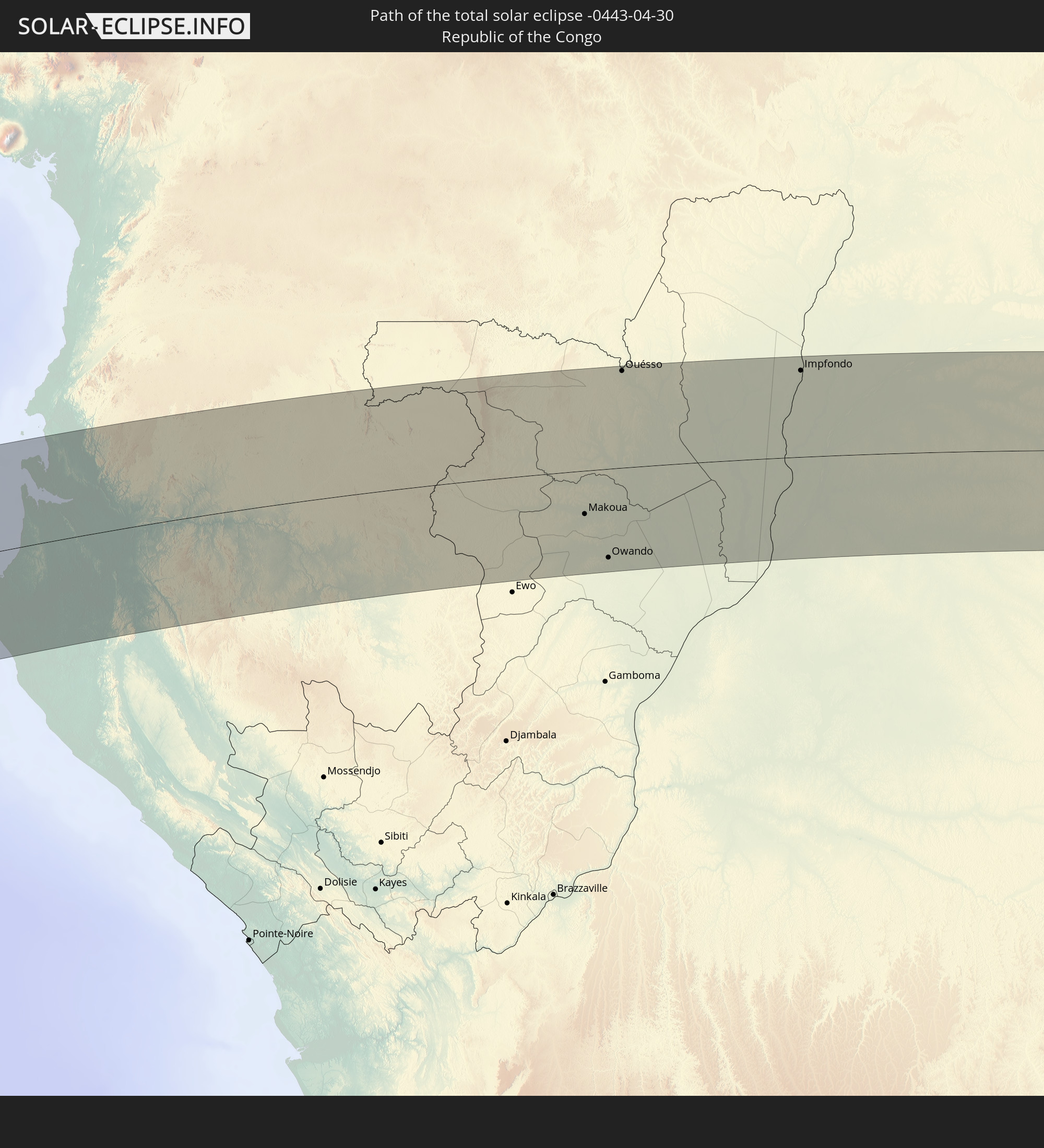 Republic of the Congo
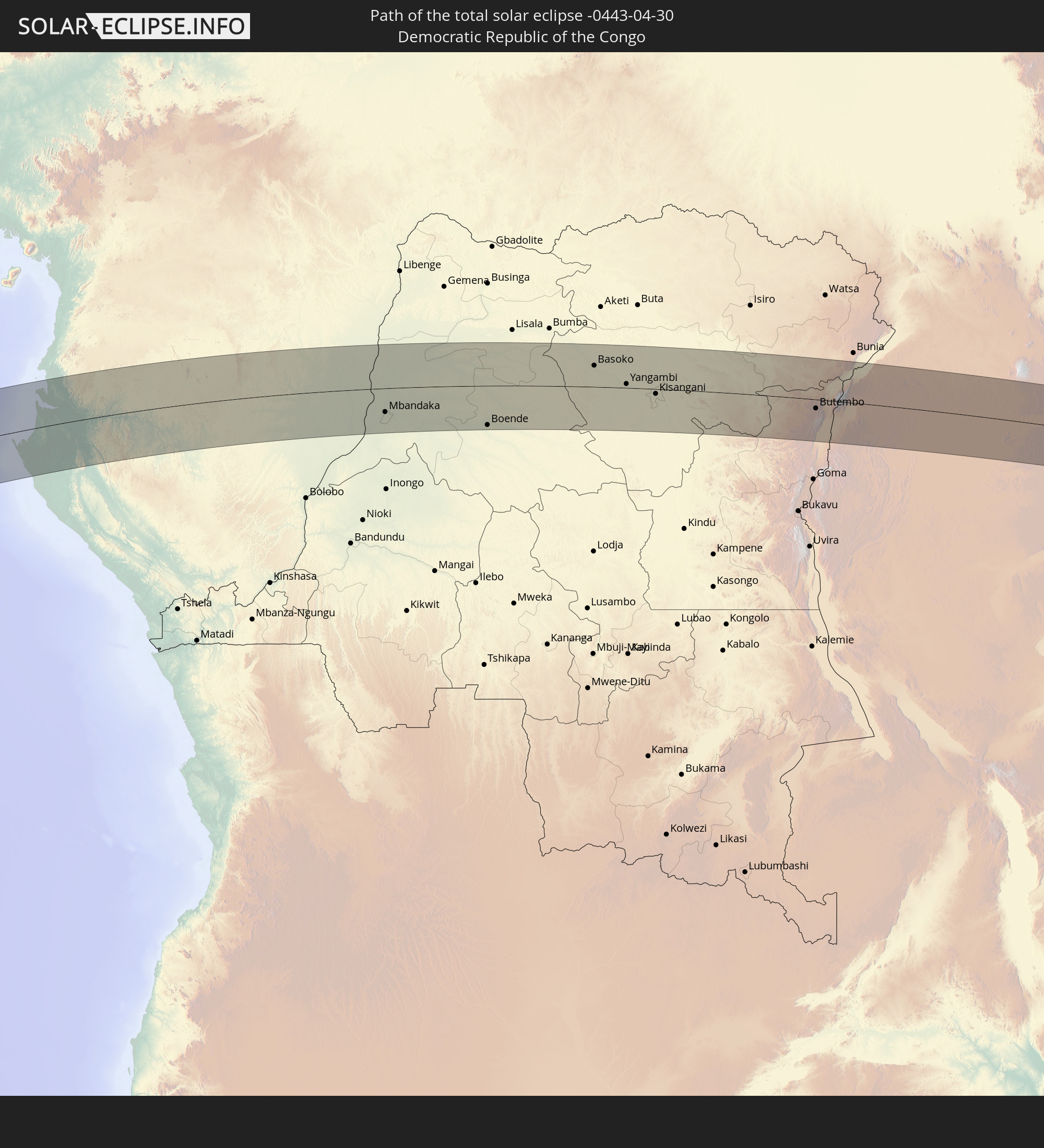 Democratic Republic of the Congo
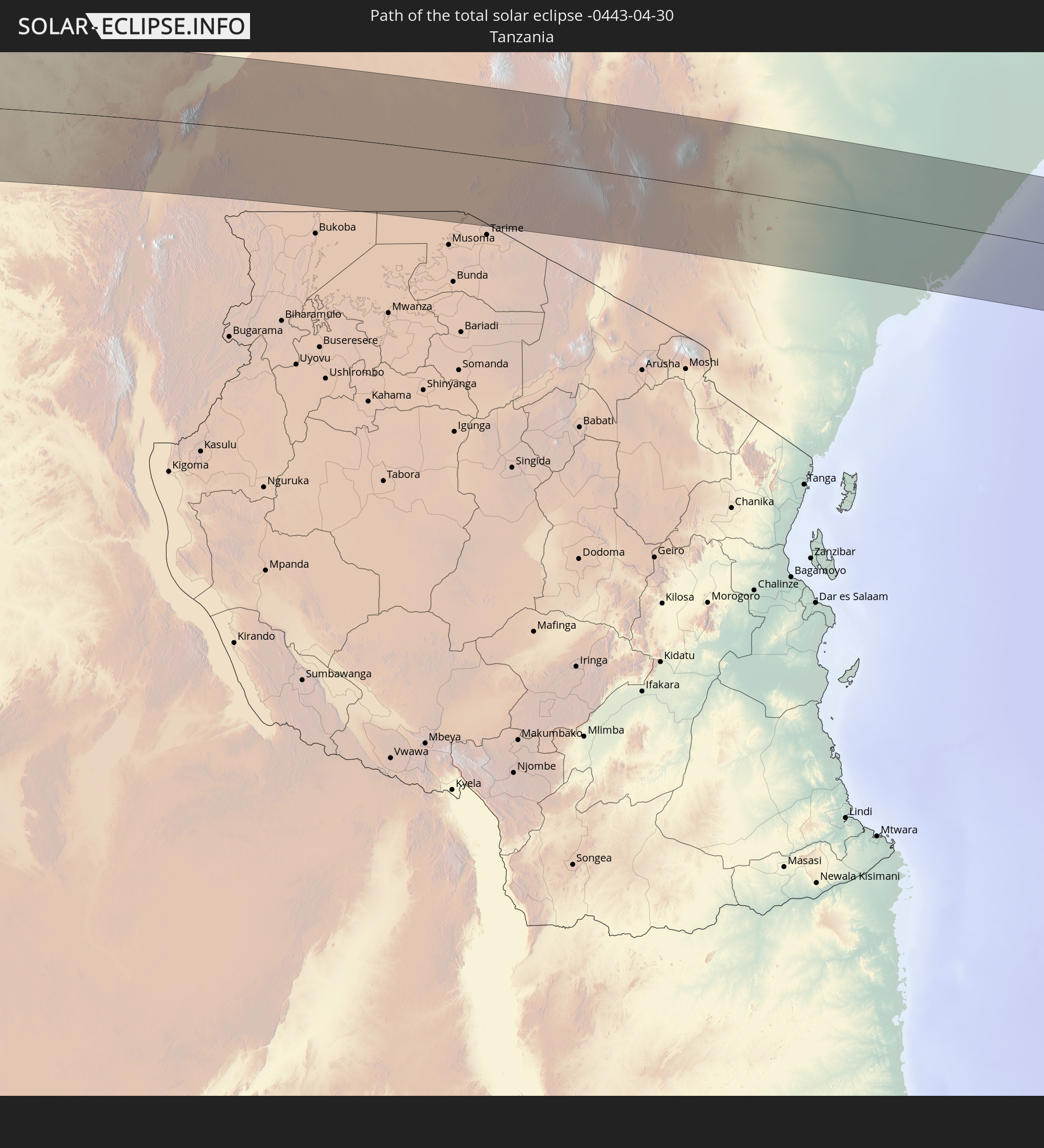 Tanzania
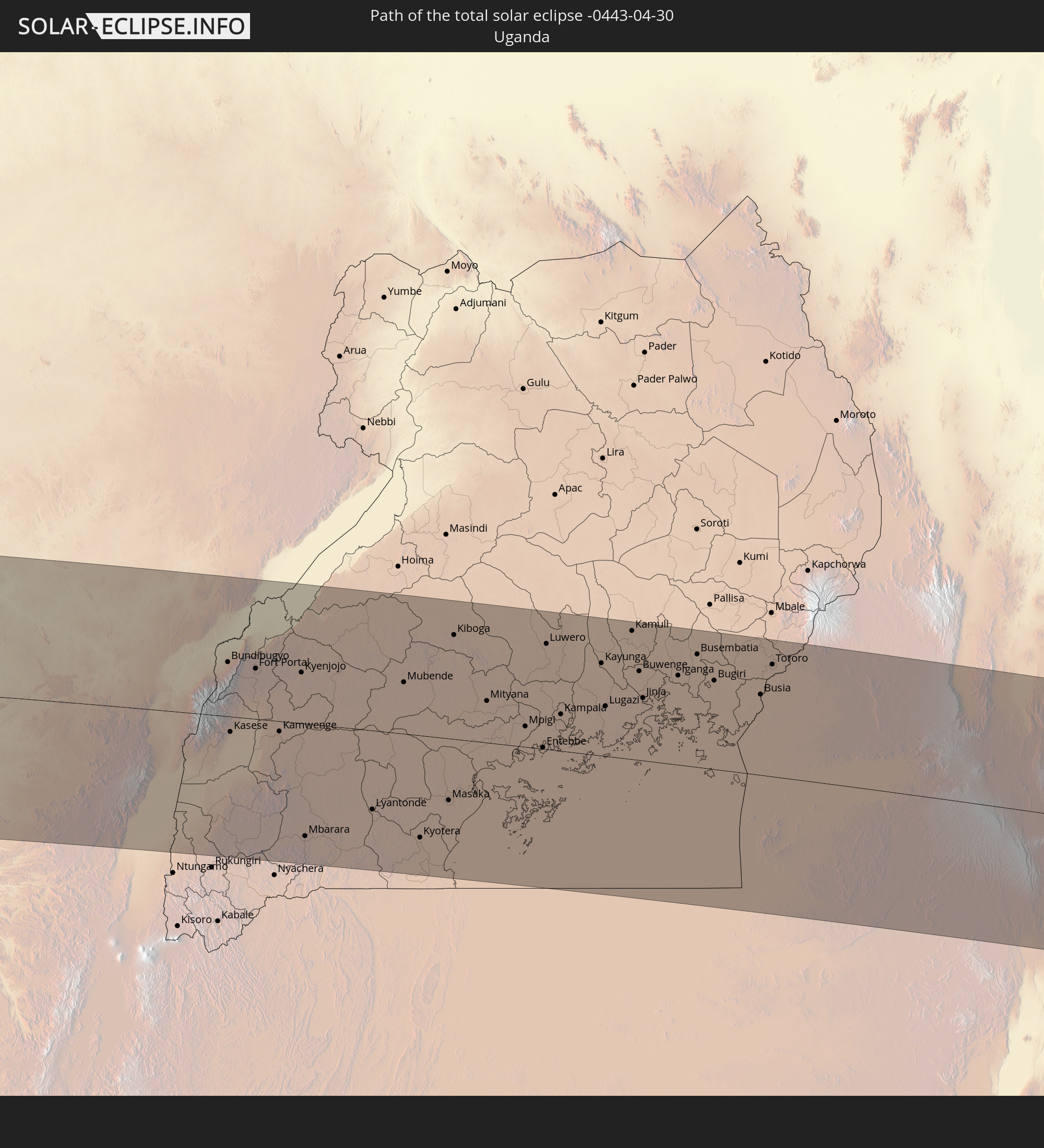 Uganda
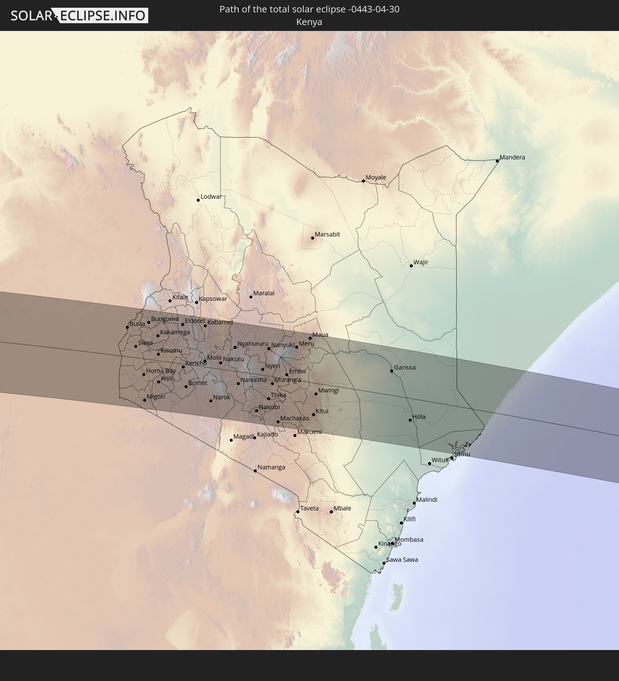 Kenya
Kenya
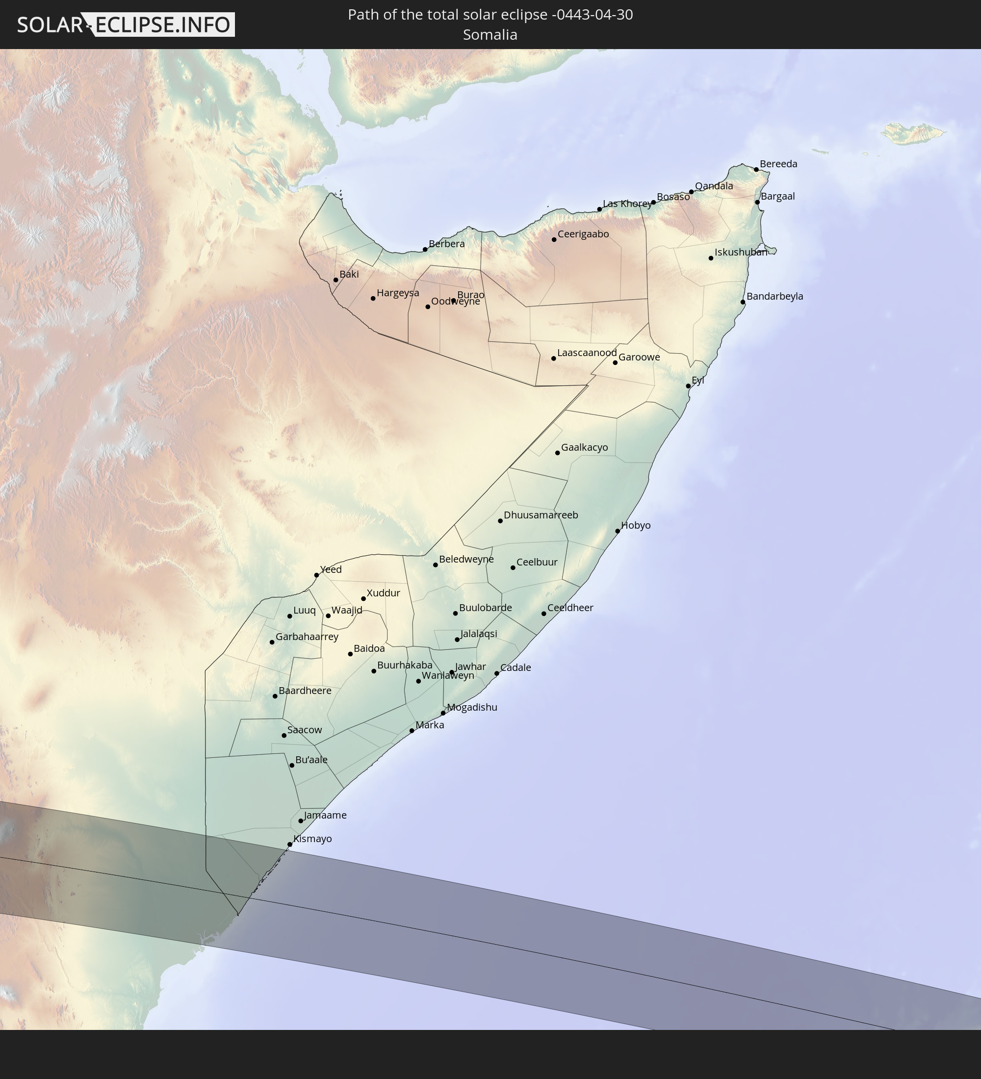 Somalia
In den folgenden Ländern ist die Sonnenfinsternis partiell zu sehen
 Antarctica
 Chile
Chile
 Colombia
 Peru
Peru
 Brazil
 Argentina
 Bolivia
 Paraguay
 Falkland Islands
 Guyana
 Uruguay
 Suriname
 French Guiana
 South Georgia and the South Sandwich Islands
 Cabo Verde
 Senegal
 Mauritania
 The Gambia
 Guinea-Bissau
 Guinea
 Saint Helena, Ascension and Tristan da Cunha
 Sierra Leone
 Mali
Mali
 Liberia
 Algeria
 Ivory Coast
 Burkina Faso
 Ghana
Ghana
 Togo
Togo
 Niger
Niger
 Benin
Benin
 Nigeria
 Equatorial Guinea
 São Tomé and Príncipe
 Tunisia
 Cameroon
 Gabon
Gabon
 Libya
Libya
 Republic of the Congo
 Angola
 Namibia
 Democratic Republic of the Congo
 Chad
Chad
 Central African Republic
 South Africa
 Botswana
 Sudan
Sudan
 Zambia
 Egypt
Egypt
 Zimbabwe
 Lesotho
 Rwanda
 Burundi
 Tanzania
 Uganda
 Mozambique
 Swaziland
 Malawi
 Ethiopia
 Kenya
Kenya
 Israel
 Saudi Arabia
 Jordan
 Eritrea
 Iraq
Iraq
 French Southern and Antarctic Lands
 Somalia
 Djibouti
 Yemen
Yemen
 Madagascar
 Comoros
 Iran
Iran
 Mayotte
 Seychelles
 Kuwait
 Bahrain
 Qatar
Qatar
 United Arab Emirates
 Oman
Oman
 Pakistan
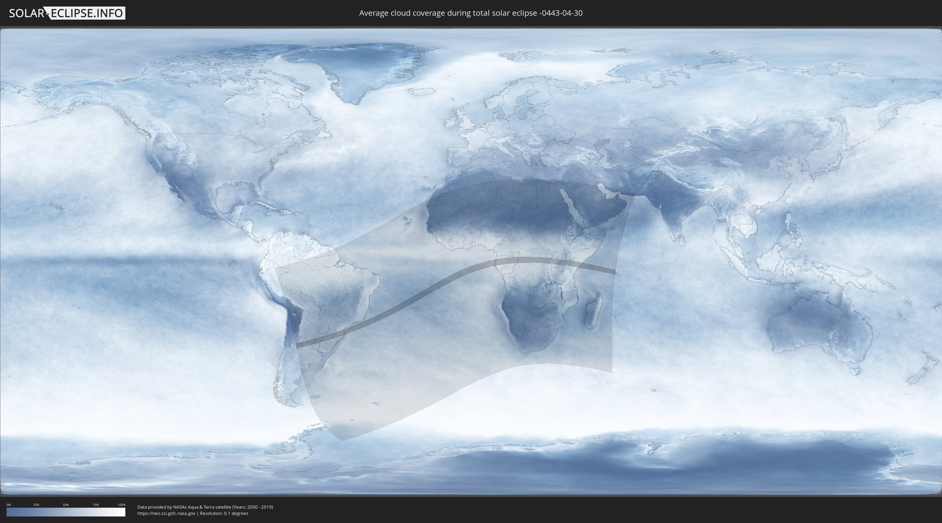
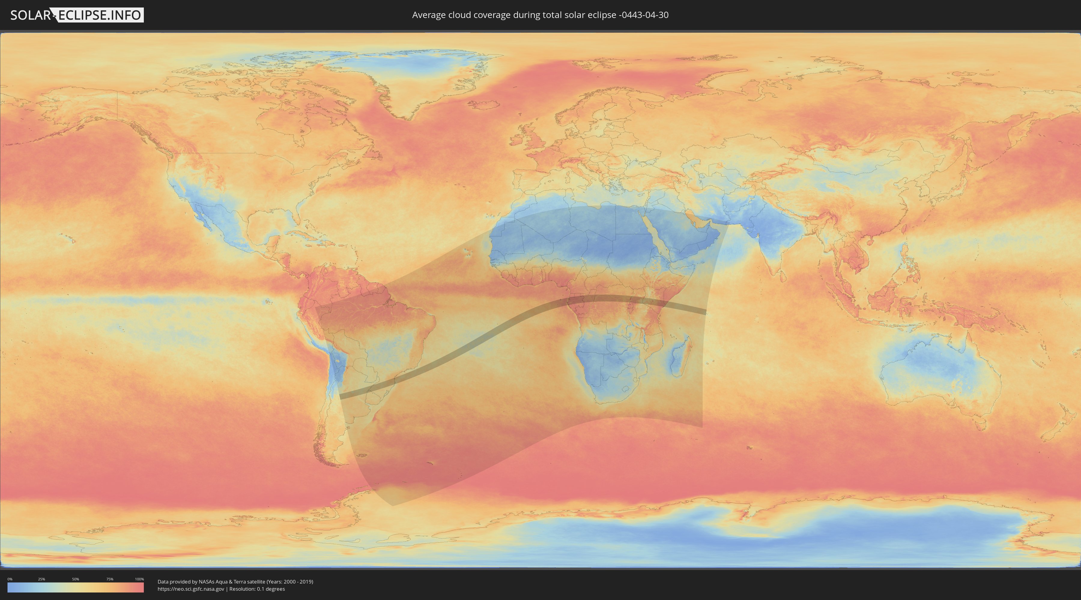
How will be the weather during the total solar eclipse on 04/30/-0443?
Where is the best place to see the total solar eclipse of 04/30/-0443?
The following maps show the average cloud coverage for the day of the total solar eclipse.
With the help of these maps, it is possible to find the place along the eclipse path, which has the best
chance of a cloudless sky.
Nevertheless, you should consider local circumstances and inform about the weather of your chosen
observation site.
The data is provided by NASAs satellites
AQUA and TERRA.
The cloud maps are averaged over a period of 19 years (2000 - 2019).
Detailed country maps
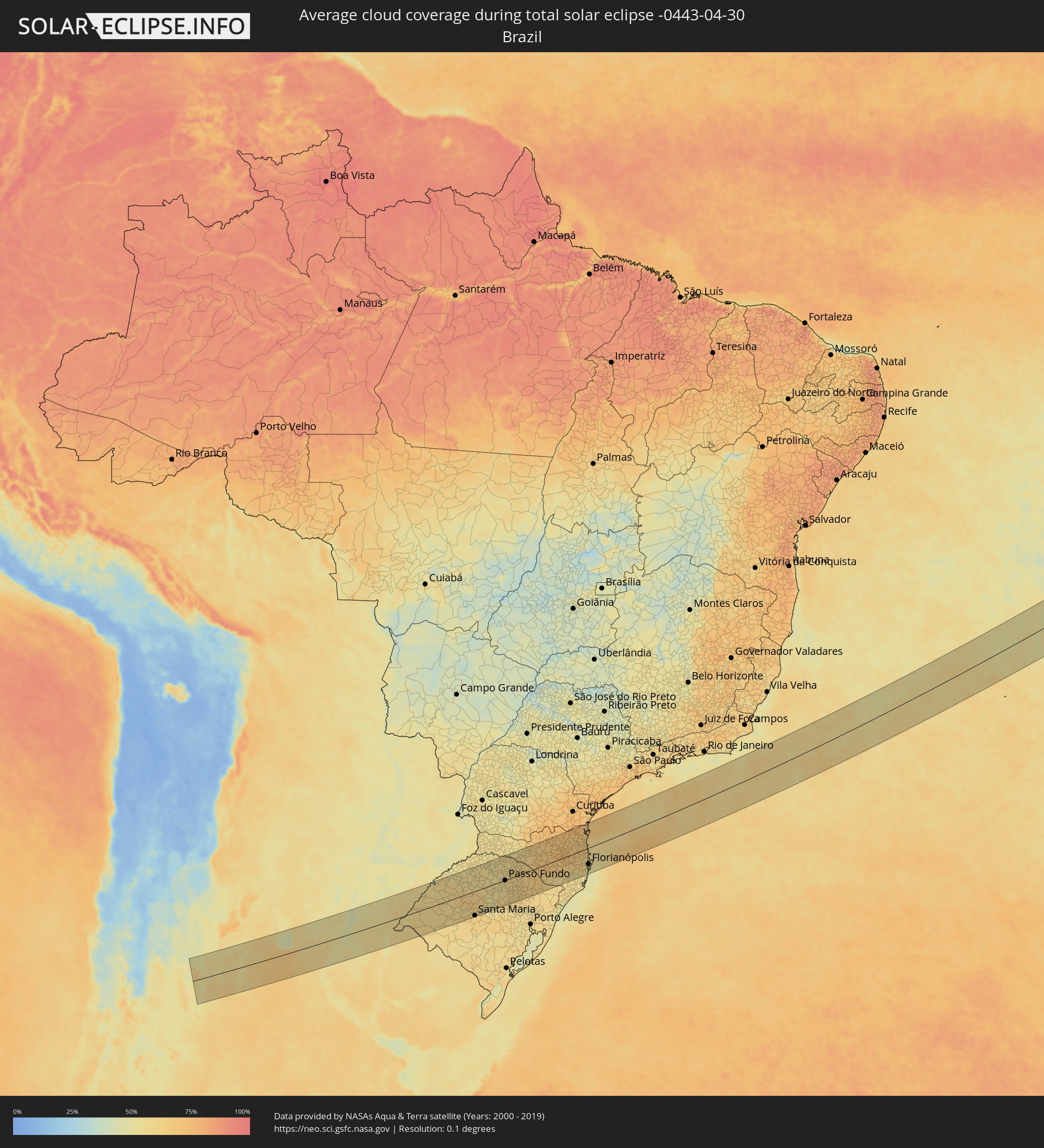 Brazil
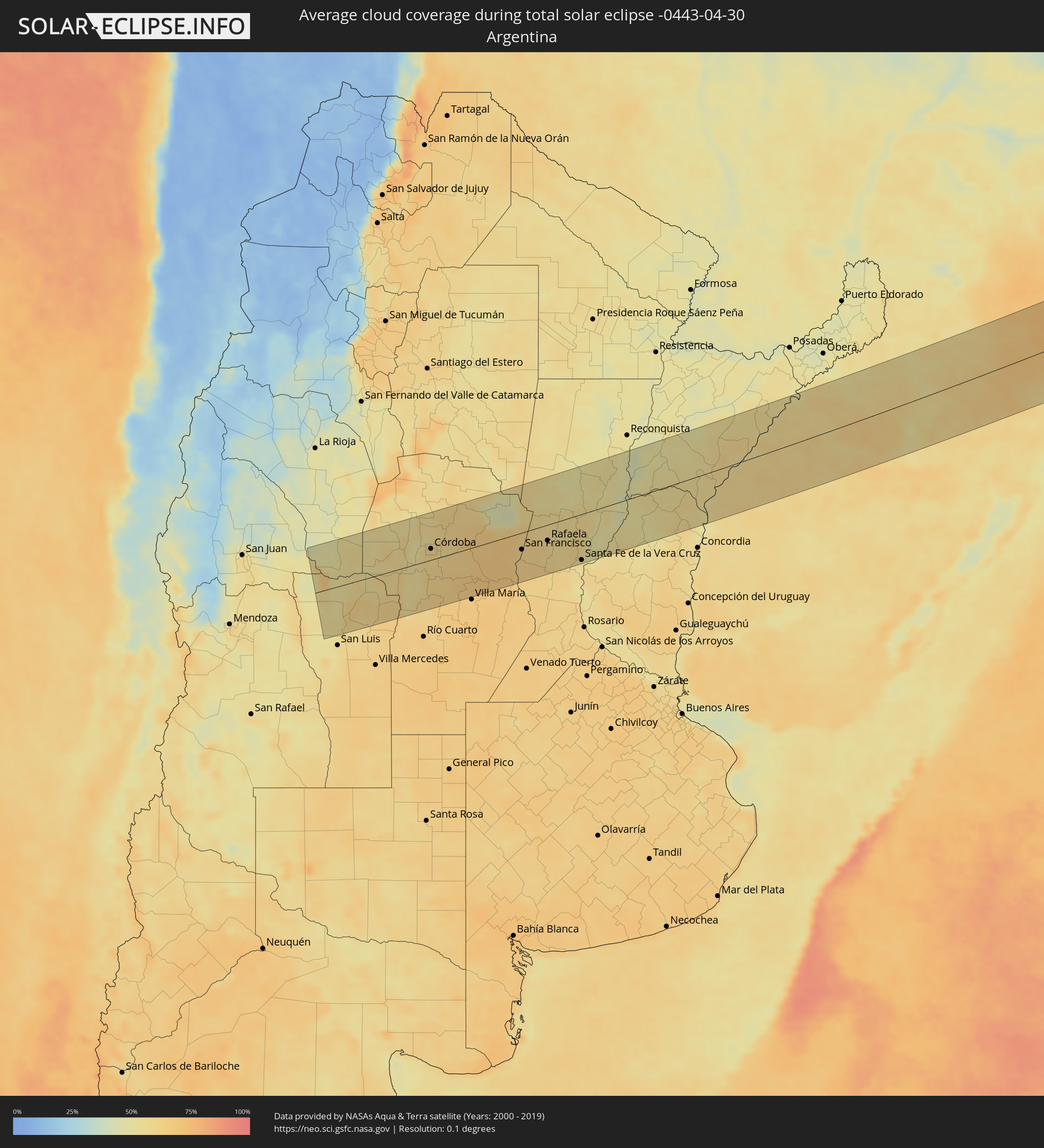 Argentina
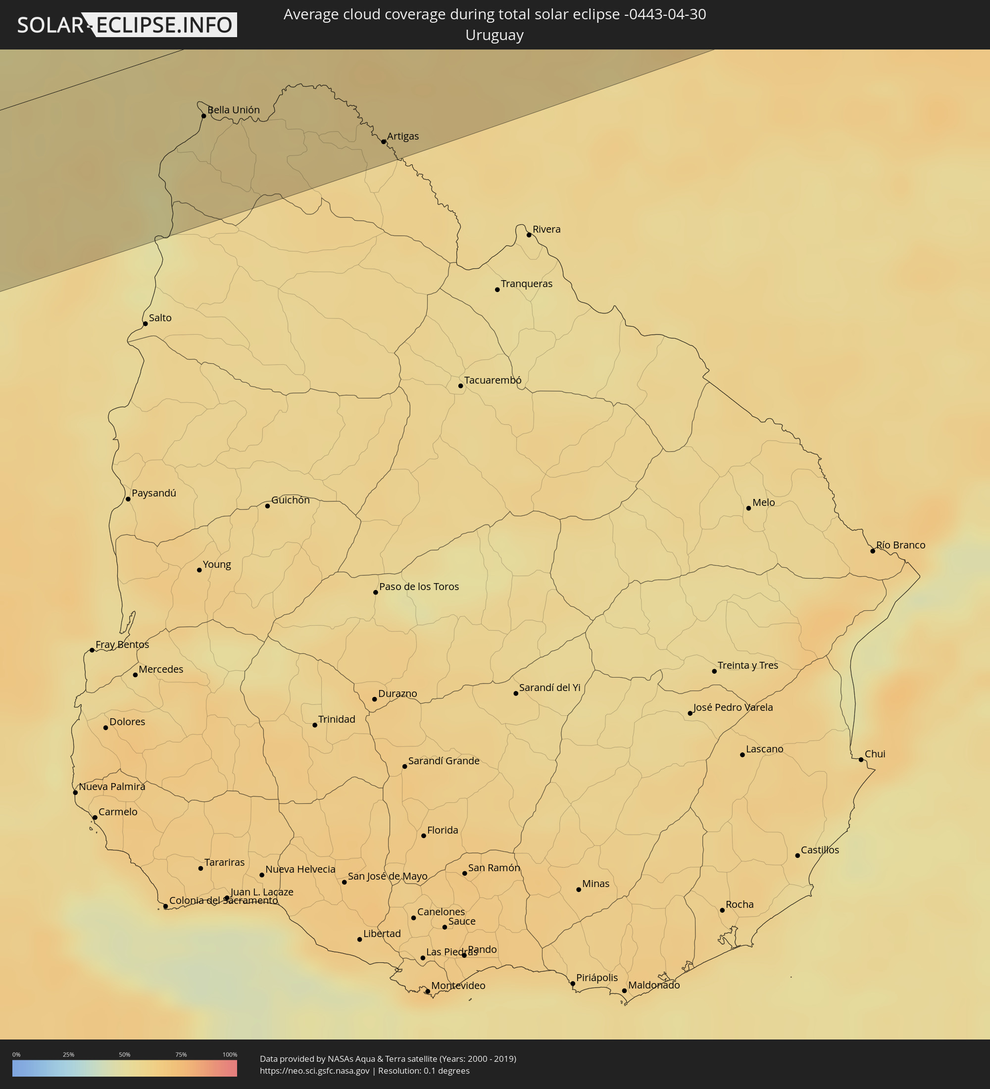 Uruguay
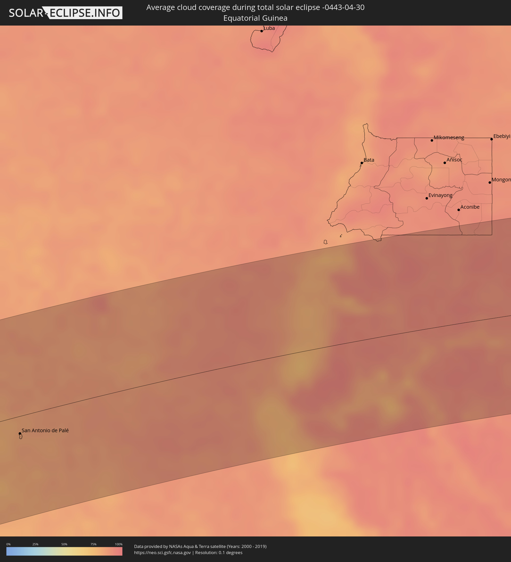 Equatorial Guinea
 São Tomé and Príncipe
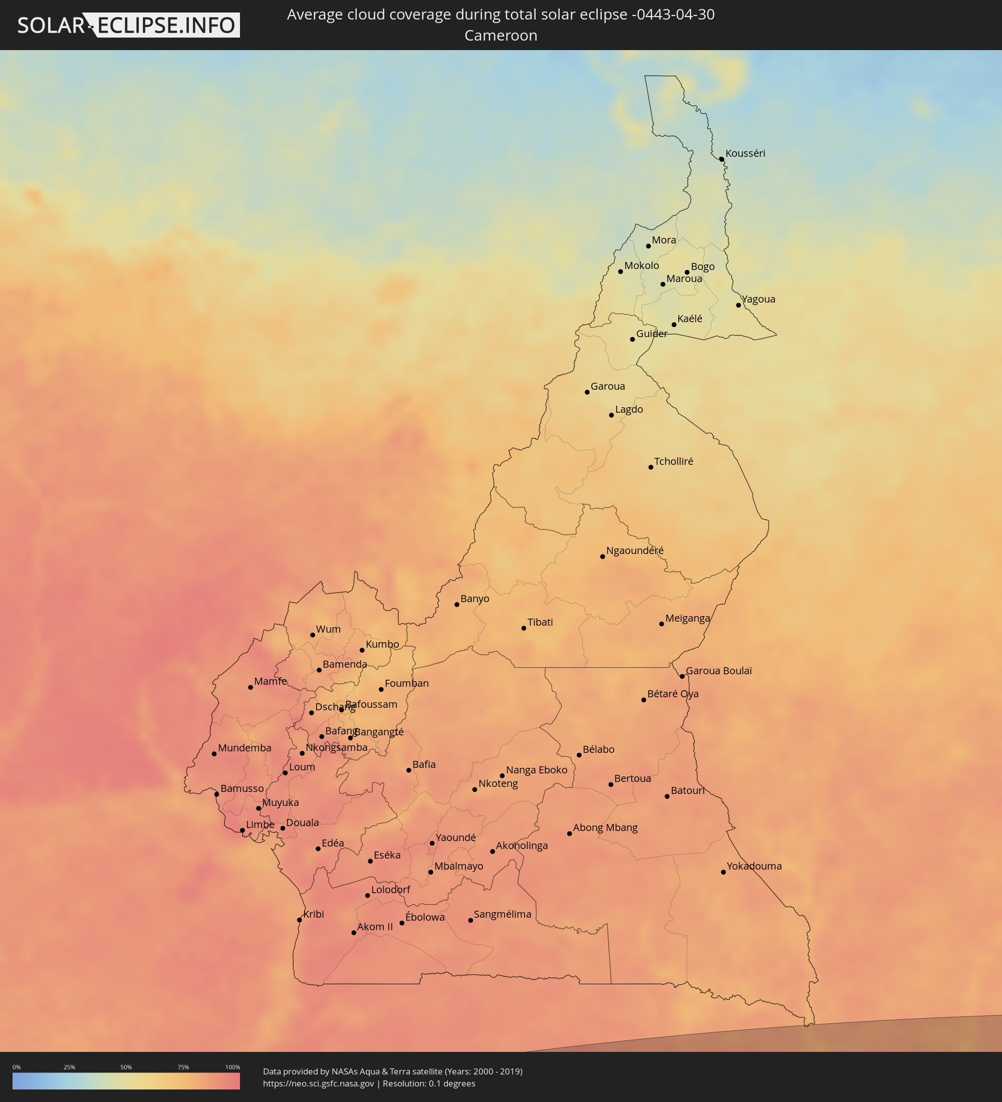 Cameroon
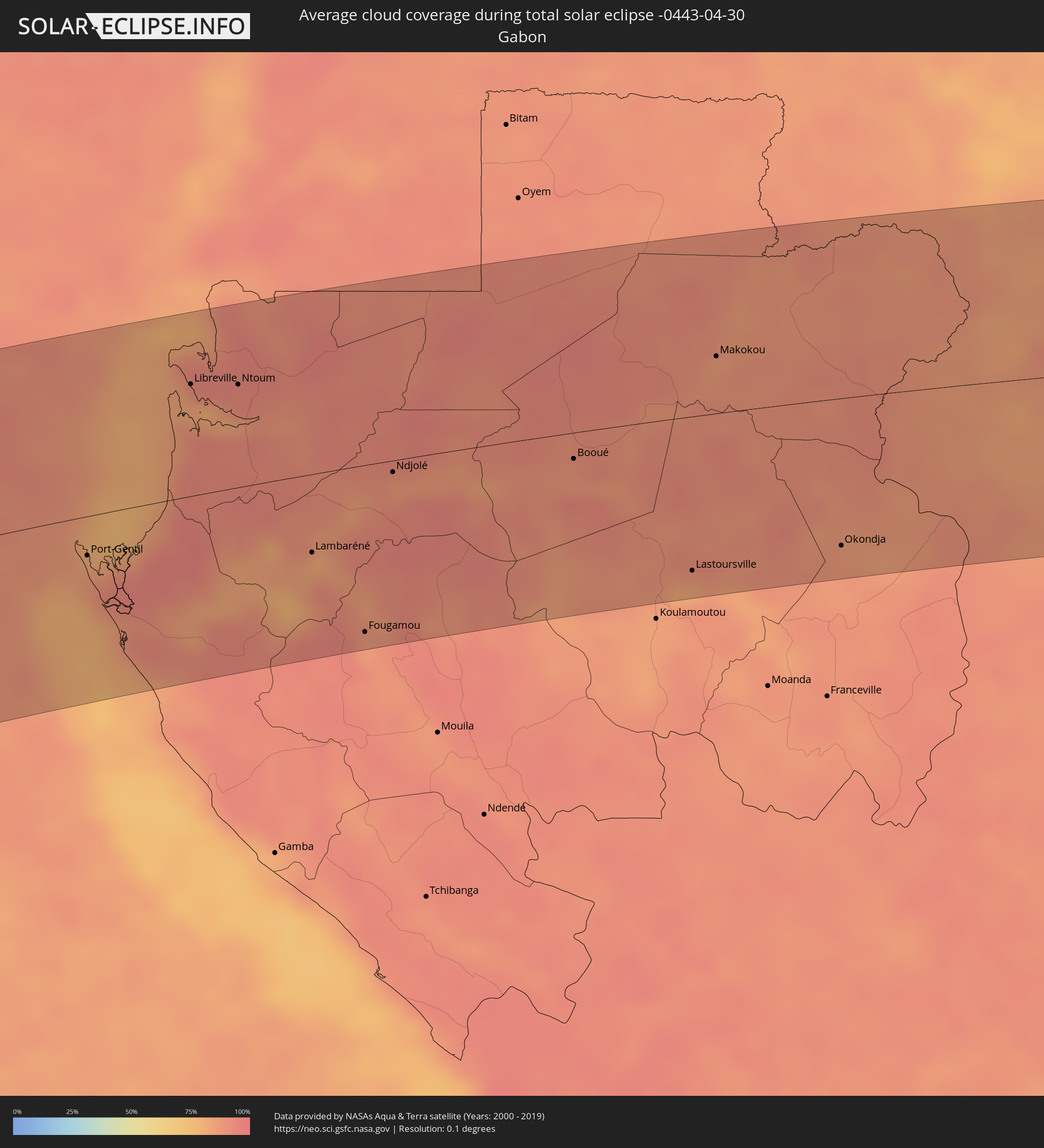 Gabon
Gabon
 Republic of the Congo
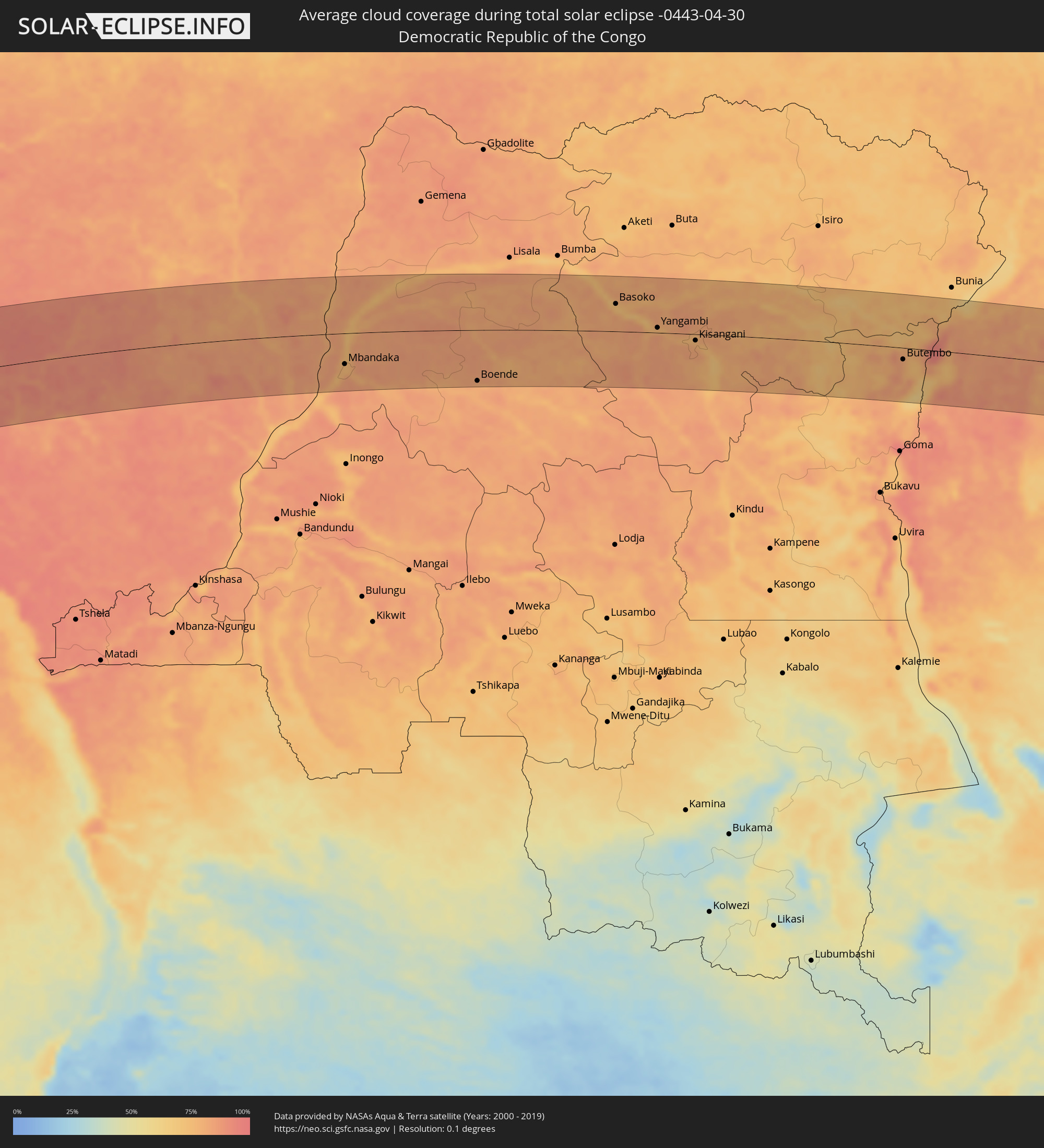 Democratic Republic of the Congo
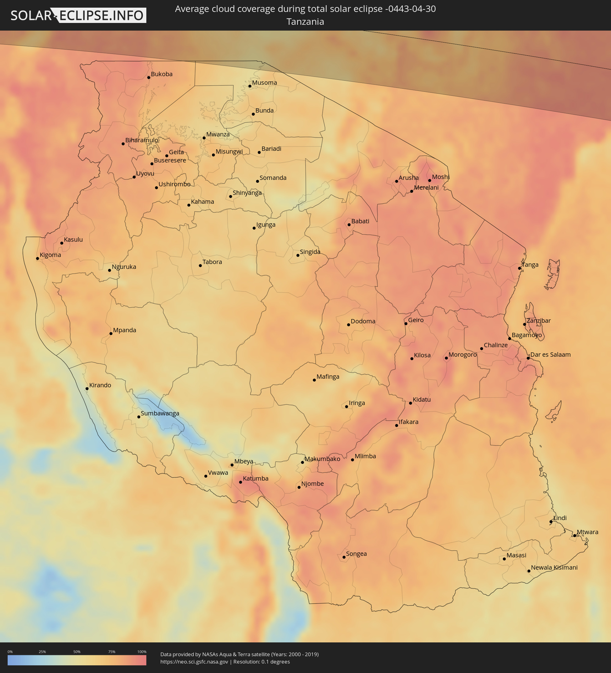 Tanzania
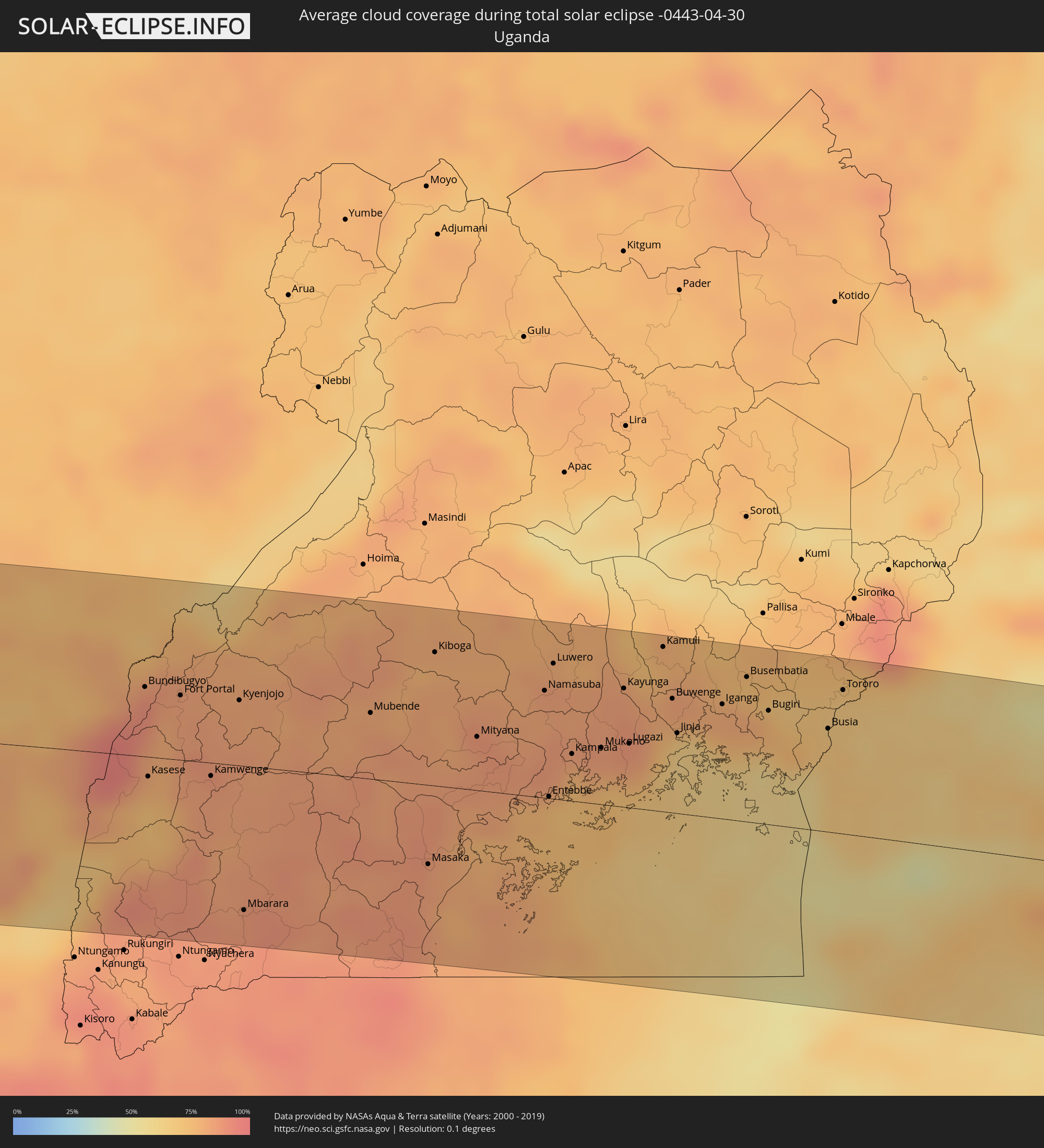 Uganda
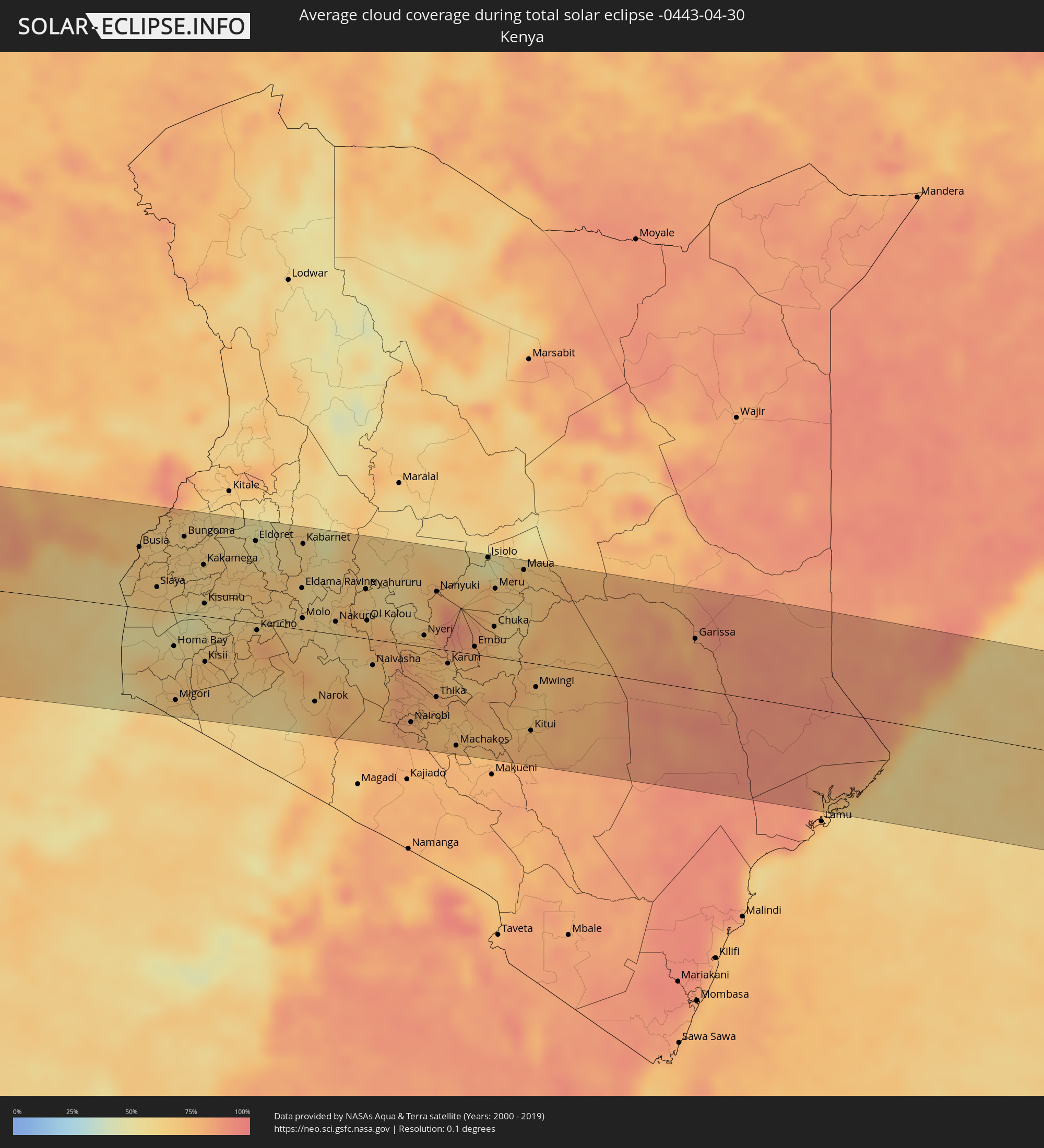 Kenya
Kenya
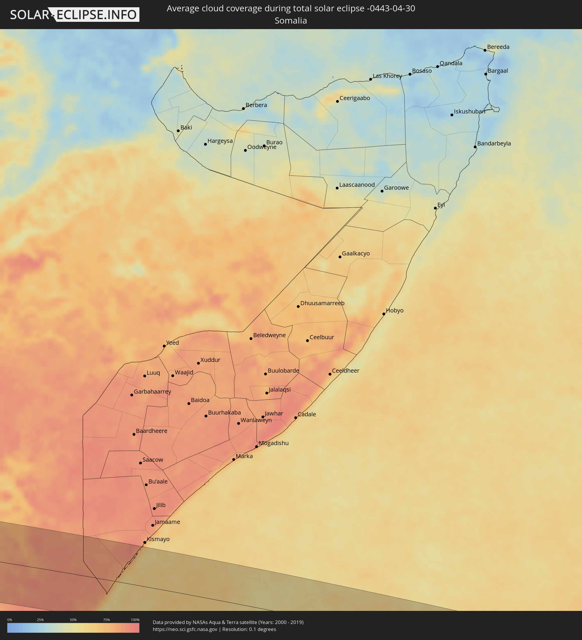 Somalia
Cities inside the path of the eclipse
The following table shows all locations with a population of more than 5,000 inside the eclipse path. Cities which have more than 100,000 inhabitants are marked bold. A click at the locations opens a detailed map.
| City | Type | Eclipse duration | Local time of max. eclipse | Distance to central line | Ø Cloud coverage |
|
Villa Dolores, Cordoba Province
|
total | - | 06:39:12 UTC-04:16 | 7 km | 59% |
|
Villa Carlos Paz, Cordoba Province
|
total | - | 06:39:07 UTC-04:16 | 31 km | 52% |
|
Cosquín, Cordoba Province
|
total | - | 06:39:03 UTC-04:16 | 49 km | 51% |
|
Alta Gracia, Cordoba Province
|
total | - | 06:39:12 UTC-04:16 | 4 km | 55% |
|
La Calera, Cordoba Province
|
total | - | 06:39:06 UTC-04:16 | 35 km | 57% |
|
Córdoba, Cordoba Province
|
total | - | 06:39:09 UTC-04:16 | 23 km | 63% |
|
Río Tercero, Cordoba Province
|
total | - | 06:39:27 UTC-04:16 | 60 km | 61% |
|
Jesús María, Cordoba Province
|
total | - | 06:39:01 UTC-04:16 | 67 km | 55% |
|
Arroyito, Cordoba Province
|
total | - | 06:39:22 UTC-04:16 | 8 km | 64% |
|
San Francisco, Cordoba Province
|
total | - | 06:39:34 UTC-04:16 | 35 km | 62% |
|
Sunchales, Santa Fe Province
|
total | - | 06:39:31 UTC-04:16 | 2 km | 56% |
|
Rafaela, Santa Fe Province
|
total | - | 06:39:39 UTC-04:16 | 33 km | 58% |
|
Esperanza, Santa Fe Province
|
total | - | 06:39:51 UTC-04:16 | 70 km | 60% |
|
Santa Fe de la Vera Cruz, Santa Fe Province
|
total | - | 06:39:58 UTC-04:16 | 96 km | 56% |
|
San Justo, Santa Fe Province
|
total | - | 06:39:43 UTC-04:16 | 10 km | 57% |
|
La Paz, Entre Ríos Province
|
total | - | 06:39:58 UTC-04:16 | 33 km | 50% |
|
Esquina, Corrientes Province
|
total | - | 06:39:46 UTC-04:16 | 41 km | 47% |
|
Mercedes, Corrientes Province
|
total | - | 06:40:00 UTC-04:16 | 85 km | 52% |
|
Curuzú Cuatiá, Corrientes Province
|
total | - | 06:40:10 UTC-04:16 | 21 km | 53% |
|
Chajarí, Entre Ríos Province
|
total | - | 06:40:29 UTC-04:16 | 83 km | 51% |
|
Monte Caseros, Corrientes Province
|
total | - | 06:40:27 UTC-04:16 | 41 km | 54% |
|
Bella Unión, Artigas
|
total | - | 07:12:25 UTC-03:44 | 43 km | 54% |
|
Uruguaiana, Rio Grande do Sul
|
total | - | 07:50:50 UTC-03:06 | 5 km | 58% |
|
Paso de los Libres, Corrientes Province
|
total | - | 06:40:30 UTC-04:16 | 1 km | 57% |
|
Artigas, Artigas
|
total | - | 07:12:53 UTC-03:44 | 93 km | 56% |
|
Santo Tomé, Corrientes Province
|
total | - | 06:40:37 UTC-04:16 | 89 km | 56% |
|
São Borja, Rio Grande do Sul
|
total | - | 07:50:59 UTC-03:06 | 76 km | 57% |
|
Alegrete, Rio Grande do Sul
|
total | - | 07:51:21 UTC-03:06 | 49 km | 58% |
|
Santo Ângelo, Rio Grande do Sul
|
total | - | 07:51:41 UTC-03:06 | 57 km | 53% |
|
Ijuí, Rio Grande do Sul
|
total | - | 07:51:52 UTC-03:06 | 36 km | 58% |
|
Santa Maria, Rio Grande do Sul
|
total | - | 07:52:13 UTC-03:06 | 103 km | 65% |
|
Cruz Alta, Rio Grande do Sul
|
total | - | 07:52:04 UTC-03:06 | 1 km | 60% |
|
Carazinho, Rio Grande do Sul
|
total | - | 07:52:24 UTC-03:06 | 9 km | 55% |
|
Passo Fundo, Rio Grande do Sul
|
total | - | 07:52:36 UTC-03:06 | 2 km | 55% |
|
Erechim, Rio Grande do Sul
|
total | - | 07:52:33 UTC-03:06 | 59 km | 57% |
|
Concórdia, Santa Catarina
|
total | - | 07:52:37 UTC-03:06 | 92 km | 58% |
|
Caçador, Santa Catarina
|
total | - | 07:53:08 UTC-03:06 | 105 km | 64% |
|
Vacaria, Rio Grande do Sul
|
total | - | 07:53:27 UTC-03:06 | 79 km | 64% |
|
Lages, Santa Catarina
|
total | - | 07:53:42 UTC-03:06 | 28 km | 67% |
|
Rio do Sul, Santa Catarina
|
total | - | 07:54:02 UTC-03:06 | 10 km | 73% |
|
São Bento do Sul, Santa Catarina
|
total | - | 07:54:06 UTC-03:06 | 100 km | 69% |
|
Jaraguá do Sul, Santa Catarina
|
total | - | 07:54:19 UTC-03:06 | 64 km | 69% |
|
Blumenau, Santa Catarina
|
total | - | 07:54:22 UTC-03:06 | 19 km | 67% |
|
Brusque, Santa Catarina
|
total | - | 07:54:29 UTC-03:06 | 5 km | 66% |
|
Joinville, Santa Catarina
|
total | - | 07:54:27 UTC-03:06 | 75 km | 69% |
|
Itajaí, Santa Catarina
|
total | - | 07:54:38 UTC-03:06 | 6 km | 66% |
|
Biguaçu, Santa Catarina
|
total | - | 07:54:42 UTC-03:06 | 55 km | 61% |
|
Florianópolis, Santa Catarina
|
total | - | 07:54:47 UTC-03:06 | 70 km | 52% |
|
San Antonio de Palé, Annobón Province
|
total | - | 13:21:05 UTC+00:13 | 23 km | 84% |
|
Port-Gentil, Ogooué-Maritime
|
total | - | 13:30:00 UTC+00:13 | 28 km | 86% |
|
Libreville, Estuaire
|
total | - | 13:32:43 UTC+00:13 | 79 km | 90% |
|
Ntoum, Estuaire
|
total | - | 13:33:29 UTC+00:13 | 73 km | 93% |
|
Lambaréné, Moyen-Ogooué
|
total | - | 13:33:41 UTC+00:13 | 56 km | 84% |
|
Fougamou, Ngouni
|
total | - | 13:34:03 UTC+00:13 | 119 km | 87% |
|
Ndjolé, Moyen-Ogooué
|
total | - | 13:35:26 UTC+00:13 | 8 km | 90% |
|
Booué, Ogooué-Ivindo
|
total | - | 13:38:19 UTC+00:13 | 19 km | 88% |
|
Lastoursville, Ogooué-Lolo
|
total | - | 13:39:30 UTC+00:13 | 110 km | 82% |
|
Makokou, Ogooué-Ivindo
|
total | - | 13:41:01 UTC+00:13 | 41 km | 86% |
|
Okondja, Haut-Ogooué
|
total | - | 13:41:52 UTC+00:13 | 106 km | 88% |
|
Makoua, Cuvette
|
total | - | 13:46:43 UTC+00:13 | 54 km | 90% |
|
Owando, Cuvette
|
total | - | 13:46:55 UTC+00:13 | 111 km | 89% |
|
Ouésso, Sangha
|
total | - | 13:48:46 UTC+00:13 | 121 km | 78% |
|
Impfondo, Likouala
|
total | - | 13:52:48 UTC+00:13 | 108 km | 80% |
|
Mbandaka, Équateur
|
total | - | 13:52:09 UTC+00:13 | 68 km | 82% |
|
Boende, Équateur
|
total | - | 13:56:53 UTC+00:13 | 112 km | 80% |
|
Basoko, Orientale
|
total | - | 15:59:12 UTC+02:10 | 61 km | 74% |
|
Yangambi, Orientale
|
total | - | 16:00:15 UTC+02:10 | 11 km | 77% |
|
Kisangani, Orientale
|
total | - | 16:01:16 UTC+02:10 | 14 km | 78% |
|
Butembo, Nord Kivu
|
total | - | 16:06:47 UTC+02:10 | 25 km | 79% |
|
Beni, Nord Kivu
|
total | - | 16:07:11 UTC+02:10 | 15 km | 73% |
|
Bundibugyo, Western Region
|
total | - | 16:24:56 UTC+02:27 | 45 km | 91% |
|
Kasese, Western Region
|
total | - | 16:24:43 UTC+02:27 | 13 km | 78% |
|
Fort Portal, Western Region
|
total | - | 16:25:10 UTC+02:27 | 42 km | 83% |
|
Kamwenge, Western Region
|
total | - | 16:25:10 UTC+02:27 | 9 km | 85% |
|
Kyenjojo, Western Region
|
total | - | 16:25:34 UTC+02:27 | 43 km | 83% |
|
Mbarara, Western Region
|
total | - | 16:25:01 UTC+02:27 | 94 km | 87% |
|
Mubende, Central Region
|
total | - | 16:26:26 UTC+02:27 | 43 km | 82% |
|
Masaka, Central Region
|
total | - | 16:26:25 UTC+02:27 | 52 km | 85% |
|
Mityana, Central Region
|
total | - | 16:27:05 UTC+02:27 | 35 km | 83% |
|
Namasuba, Central Region
|
total | - | 16:27:38 UTC+02:27 | 70 km | 83% |
|
Entebbe, Central Region
|
total | - | 16:27:23 UTC+02:27 | 1 km | 76% |
|
Wakiso, Central Region
|
total | - | 16:27:33 UTC+02:27 | 39 km | 85% |
|
Luwero, Central Region
|
total | - | 16:27:45 UTC+02:27 | 88 km | 84% |
|
Kampala, Central Region
|
total | - | 16:27:39 UTC+02:27 | 31 km | 77% |
|
Kireka, Central Region
|
total | - | 16:27:44 UTC+02:27 | 35 km | 77% |
|
Mukono, Central Region
|
total | - | 16:27:51 UTC+02:27 | 37 km | 85% |
|
Kayunga, Central Region
|
total | - | 16:28:08 UTC+02:27 | 77 km | 84% |
|
Lugazi, Central Region
|
total | - | 16:28:02 UTC+02:27 | 42 km | 86% |
|
Jinja, Eastern Region
|
total | - | 16:28:21 UTC+02:27 | 52 km | 63% |
|
Iganga, Eastern Region
|
total | - | 16:28:42 UTC+02:27 | 75 km | 81% |
|
Bugiri, Eastern Region
|
total | - | 16:28:57 UTC+02:27 | 74 km | 79% |
|
Busia, Eastern Region
|
total | - | 16:29:16 UTC+02:27 | 67 km | 69% |
|
Busia, Busia
|
total | - | 16:29:17 UTC+02:27 | 67 km | 69% |
|
Tororo, Eastern Region
|
total | - | 16:29:27 UTC+02:27 | 94 km | 67% |
|
Lugulu, Busia
|
total | - | 16:29:27 UTC+02:27 | 62 km | 65% |
|
Homa Bay, Homa Bay
|
total | - | 16:29:12 UTC+02:27 | 37 km | 58% |
|
Migori, Migori
|
total | - | 16:28:58 UTC+02:27 | 96 km | 61% |
|
Mumias, Kakamega
|
total | - | 16:29:36 UTC+02:27 | 58 km | 65% |
|
Bungoma, Bungoma
|
total | - | 16:29:46 UTC+02:27 | 85 km | 64% |
|
Kakamega, Kakamega
|
total | - | 16:29:50 UTC+02:27 | 57 km | 63% |
|
Kisumu, Kisumu
|
total | - | 16:29:41 UTC+02:27 | 14 km | 53% |
|
Eldoret, Uasin Gishu
|
total | - | 16:30:25 UTC+02:27 | 90 km | 55% |
|
Kericho, Kericho
|
total | - | 16:30:03 UTC+02:27 | 8 km | 79% |
|
Narok, Narok
|
total | - | 16:30:17 UTC+02:27 | 77 km | 73% |
|
Nakuru, Nakuru
|
total | - | 16:30:48 UTC+02:27 | 14 km | 60% |
|
Nyahururu, Laikipia
|
total | - | 16:31:12 UTC+02:27 | 54 km | 64% |
|
Ol Kalou, Nyandarua
|
total | - | 16:31:05 UTC+02:27 | 20 km | 70% |
|
Naivasha, Nakuru
|
total | - | 16:30:57 UTC+02:27 | 28 km | 65% |
|
Nairobi, Nairobi Area
|
total | - | 16:31:02 UTC+02:27 | 85 km | 81% |
|
Nyeri, Nyeri
|
total | - | 16:31:31 UTC+02:27 | 13 km | 72% |
|
Thika, Nairobi Area
|
total | - | 16:31:21 UTC+02:27 | 53 km | 74% |
|
Nanyuki, Laikipia
|
total | - | 16:31:48 UTC+02:27 | 63 km | 79% |
|
Embu, Embu
|
total | - | 16:31:53 UTC+02:27 | 9 km | 79% |
|
Isiolo, Isiolo
|
total | - | 16:32:20 UTC+02:27 | 108 km | 52% |
|
Meru, Meru
|
total | - | 16:32:17 UTC+02:27 | 76 km | 68% |
|
Garissa, Garissa
|
total | - | 16:33:35 UTC+02:27 | 55 km | 79% |