Total solar eclipse of 09/26/-1325
| Day of week: | Friday |
| Maximum duration of eclipse: | 03m30s |
| Maximum width of eclipse path: | 229 km |
| Saros cycle: | 42 |
| Coverage: | 100% |
| Magnitude: | 1.0478 |
| Gamma: | -0.7348 |
Wo kann man die Sonnenfinsternis vom 09/26/-1325 sehen?
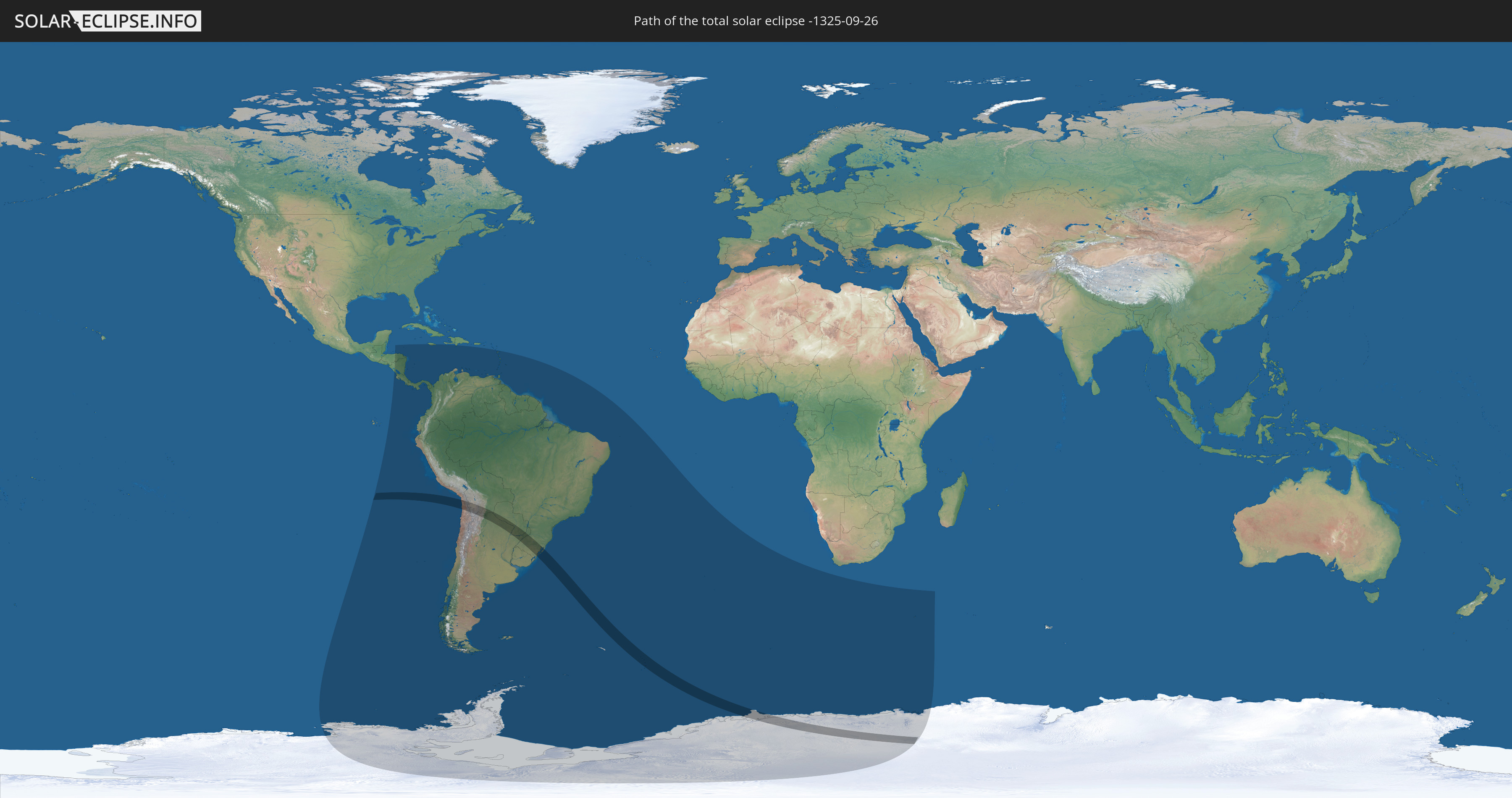
Die Sonnenfinsternis am 09/26/-1325 kann man in 34 Ländern als partielle Sonnenfinsternis beobachten.
Der Finsternispfad verläuft durch 7 Länder. Nur in diesen Ländern ist sie als total Sonnenfinsternis zu sehen.
In den folgenden Ländern ist die Sonnenfinsternis total zu sehen
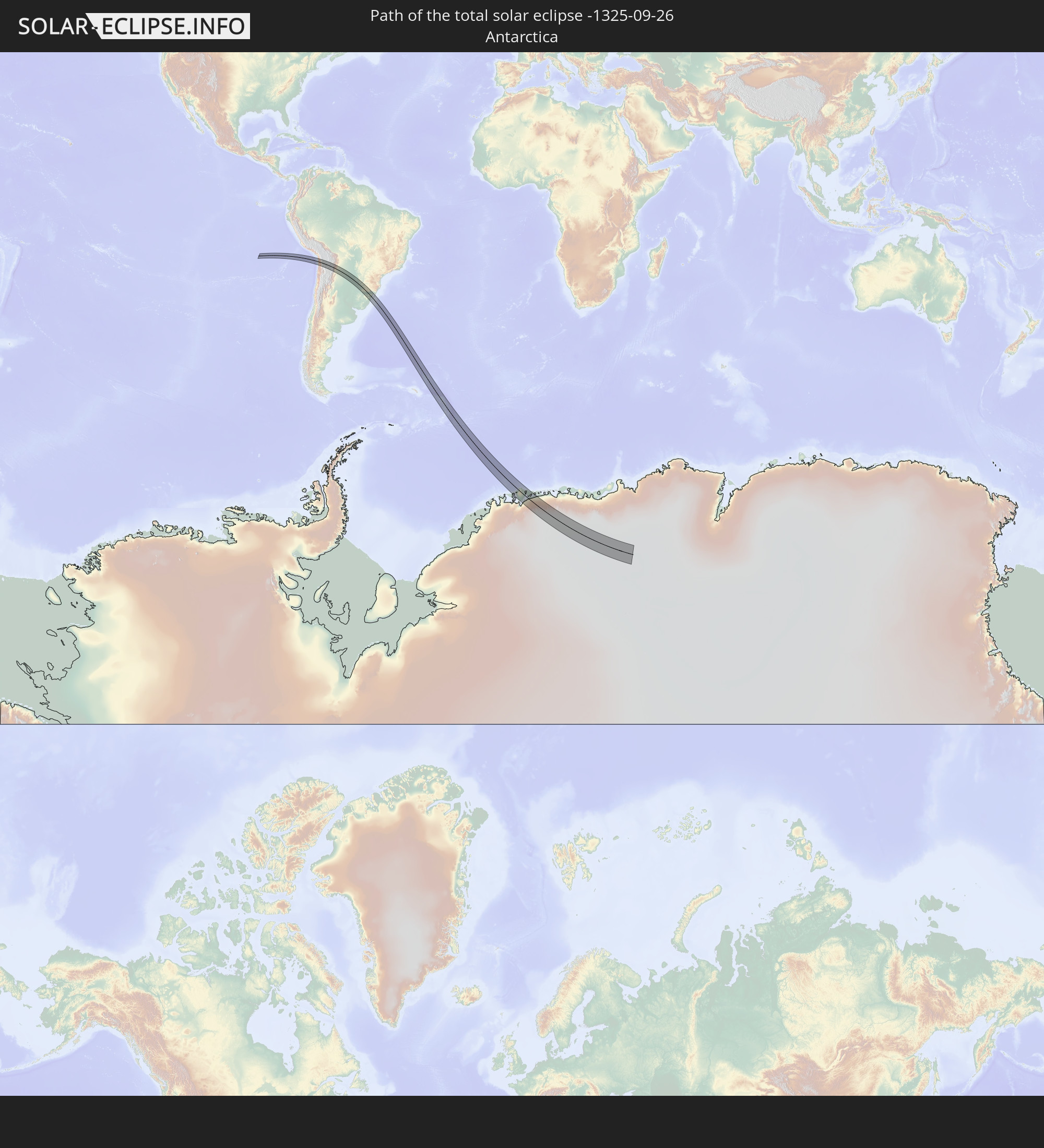 Antarctica
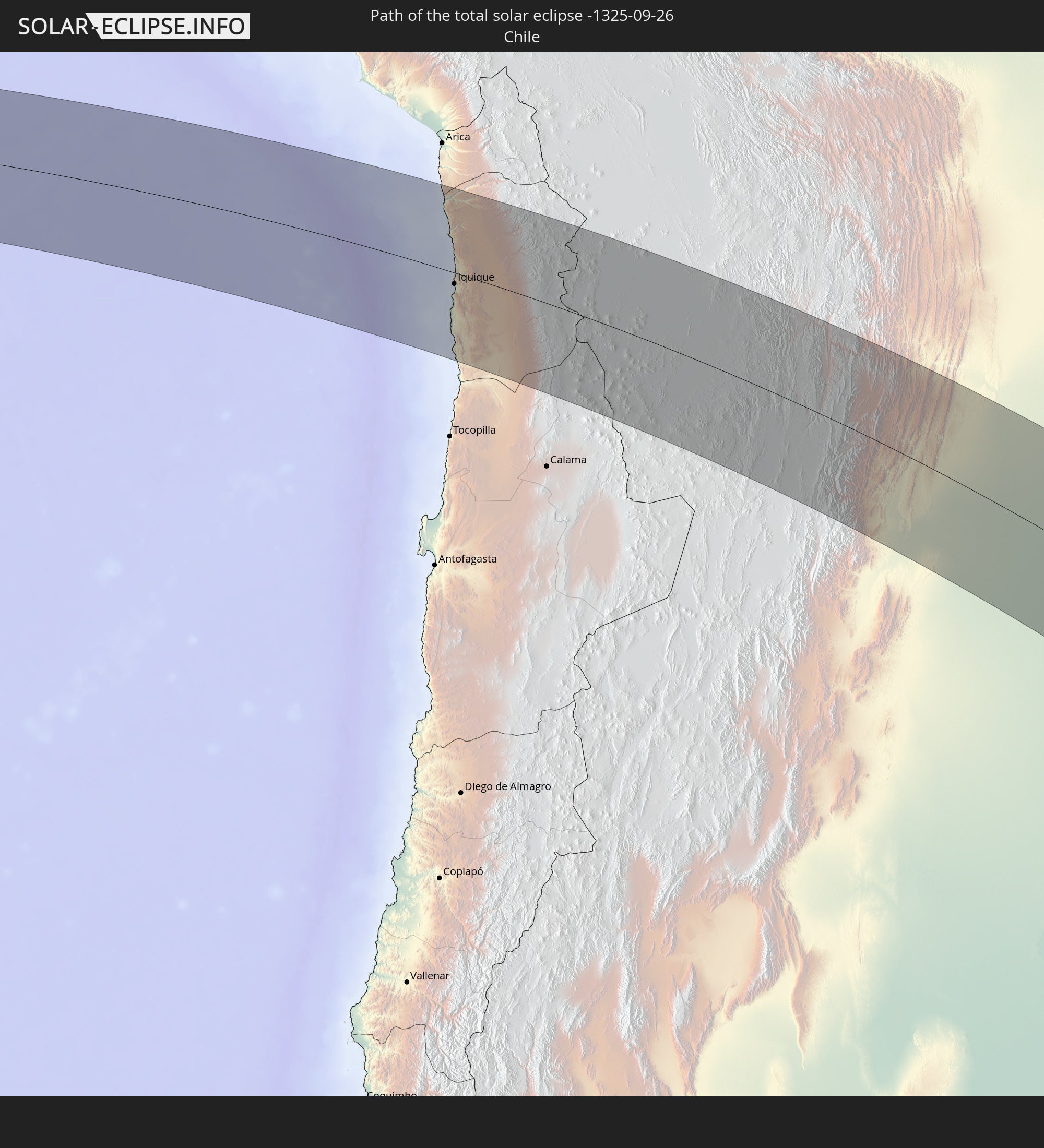 Chile
Chile
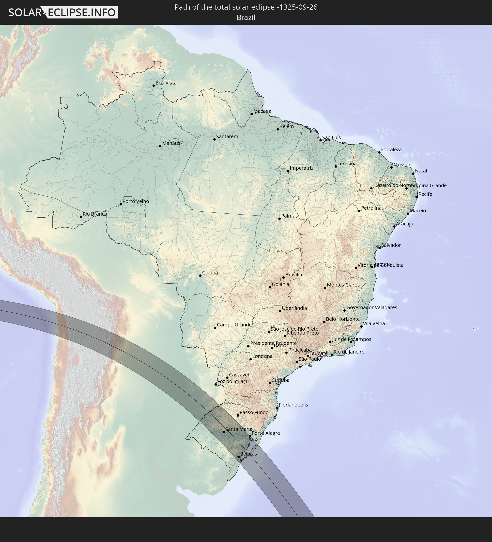 Brazil
 Argentina
 Bolivia
 Paraguay
 South Georgia and the South Sandwich Islands
In den folgenden Ländern ist die Sonnenfinsternis partiell zu sehen
 Antarctica
 Chile
Chile
 Ecuador
 Honduras
 Nicaragua
 Costa Rica
 Panama
 Colombia
 Peru
Peru
 Jamaica
 Brazil
 Argentina
 Venezuela
 Dominican Republic
 Aruba
Aruba
 Bolivia
 Paraguay
 Montserrat
 Trinidad and Tobago
 Guadeloupe
 Grenada
 Dominica
 Saint Vincent and the Grenadines
 Falkland Islands
 Guyana
 Martinique
 Saint Lucia
 Barbados
 Uruguay
 Suriname
 French Guiana
 South Georgia and the South Sandwich Islands
 Saint Helena, Ascension and Tristan da Cunha
 Bouvet Island
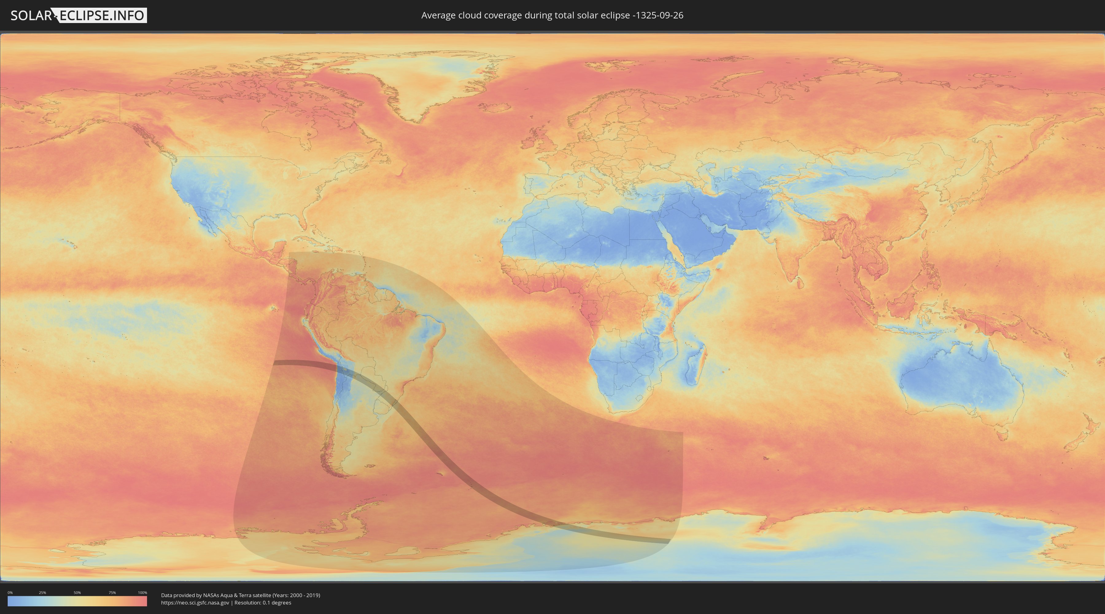
How will be the weather during the total solar eclipse on 09/26/-1325?
Where is the best place to see the total solar eclipse of 09/26/-1325?
The following maps show the average cloud coverage for the day of the total solar eclipse.
With the help of these maps, it is possible to find the place along the eclipse path, which has the best
chance of a cloudless sky.
Nevertheless, you should consider local circumstances and inform about the weather of your chosen
observation site.
The data is provided by NASAs satellites
AQUA and TERRA.
The cloud maps are averaged over a period of 19 years (2000 - 2019).

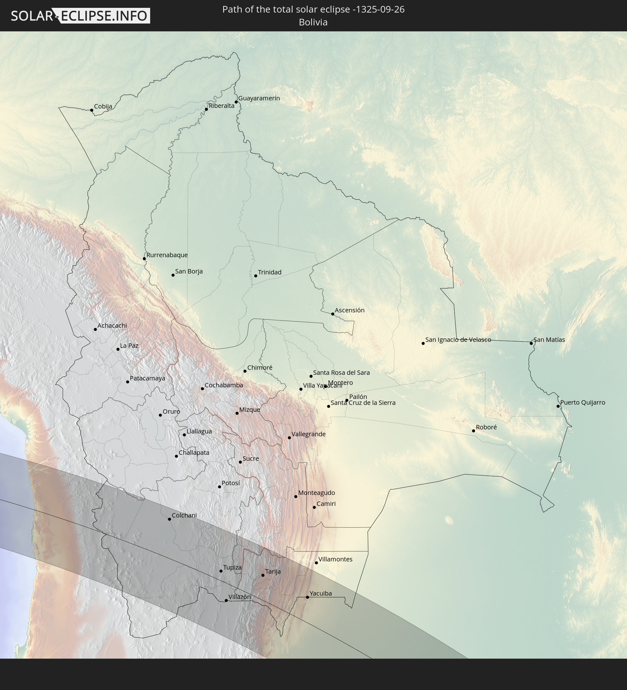
Detailed country maps
 Antarctica
 Chile
Chile
 Brazil
 Argentina
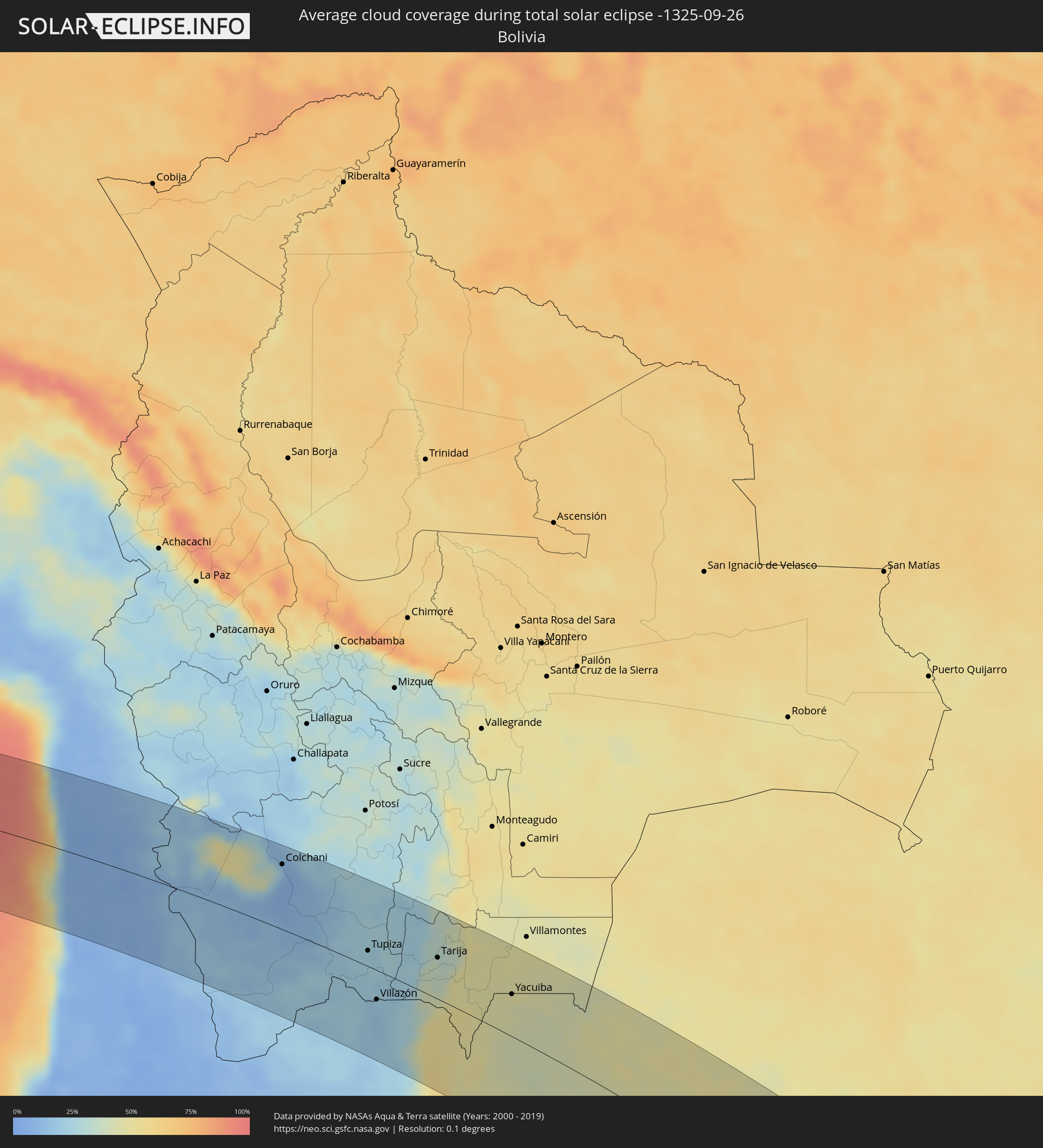 Bolivia
 Paraguay
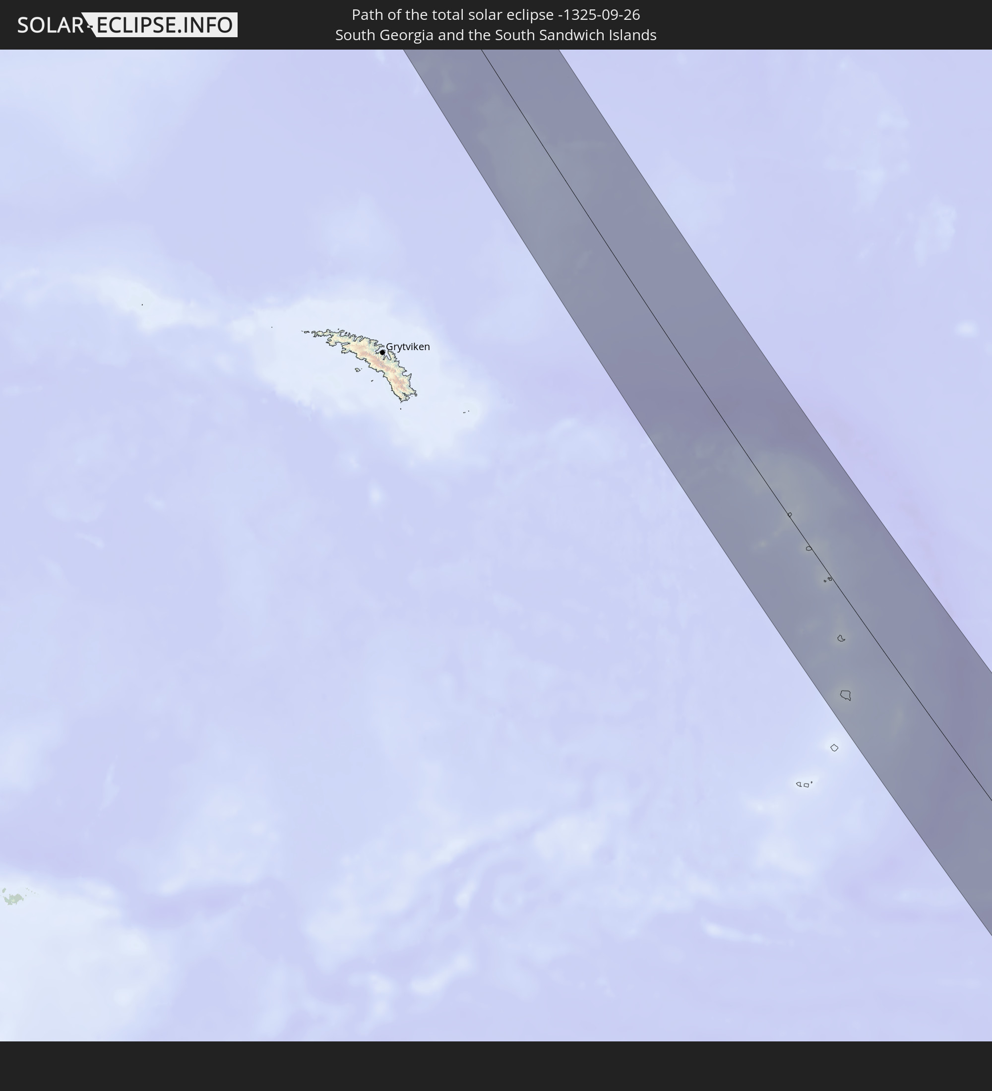
 South Georgia and the South Sandwich Islands
Cities inside the path of the eclipse
The following table shows all locations with a population of more than 5,000 inside the eclipse path. Cities which have more than 100,000 inhabitants are marked bold. A click at the locations opens a detailed map.
| City | Type | Eclipse duration | Local time of max. eclipse | Distance to central line | Ø Cloud coverage |
|
Iquique, Tarapacá
|
total | - | 07:34:56 UTC-04:42 | 15 km | 28% |
|
Colchani, Potosí
|
total | - | 07:47:52 UTC-04:32 | 89 km | 12% |
|
Uyuni, Potosí
|
total | - | 07:48:15 UTC-04:32 | 77 km | 8% |
|
Tupiza, Potosí
|
total | - | 07:50:56 UTC-04:32 | 21 km | 23% |
|
Abra Pampa, Jujuy Province
|
total | - | 08:09:00 UTC-04:16 | 107 km | 19% |
|
Villazón, Potosí
|
total | - | 07:52:11 UTC-04:32 | 39 km | 20% |
|
La Quiaca, Jujuy Province
|
total | - | 08:08:01 UTC-04:16 | 41 km | 20% |
|
Tarija, Tarija
|
total | - | 07:52:02 UTC-04:32 | 54 km | 34% |
|
San Ramón de la Nueva Orán, Salta Province
|
total | - | 08:11:04 UTC-04:16 | 87 km | 50% |
|
Embarcación, Salta Province
|
total | - | 08:11:25 UTC-04:16 | 83 km | 46% |
|
General Enrique Mosconi, Salta Province
|
total | - | 08:10:37 UTC-04:16 | 9 km | 43% |
|
Tartagal, Salta Province
|
total | - | 08:10:29 UTC-04:16 | 1 km | 42% |
|
Yacuiba, Tarija
|
total | - | 07:53:55 UTC-04:32 | 55 km | 47% |
|
Ingeniero Guillermo N. Juárez, Formosa Province
|
total | - | 08:15:00 UTC-04:16 | 37 km | 45% |
|
Las Lomitas, Formosa Province
|
total | - | 08:17:52 UTC-04:16 | 44 km | 45% |
|
Ibarreta, Formosa Province
|
total | - | 08:19:37 UTC-04:16 | 48 km | 45% |
|
Comandante Fontana, Formosa Province
|
total | - | 08:20:03 UTC-04:16 | 49 km | 45% |
|
El Colorado, Formosa Province
|
total | - | 08:22:12 UTC-04:16 | 118 km | 47% |
|
Palo Santo, Formosa Province
|
total | - | 08:20:52 UTC-04:16 | 50 km | 46% |
|
Pirané, Formosa Province
|
total | - | 08:21:27 UTC-04:16 | 51 km | 48% |
|
Pilar, Ñeembucú
|
total | - | 08:50:39 UTC-03:50 | 101 km | 48% |
|
Formosa, Formosa Province
|
total | - | 08:23:22 UTC-04:16 | 34 km | 49% |
|
Clorinda, Formosa Province
|
total | - | 08:22:15 UTC-04:16 | 73 km | 49% |
|
Nanawa, Presidente Hayes
|
total | - | 08:48:25 UTC-03:50 | 78 km | 49% |
|
Asunción, Asunción
|
total | - | 08:48:31 UTC-03:50 | 76 km | 51% |
|
Lambaré, Central
|
total | - | 08:48:38 UTC-03:50 | 74 km | 51% |
|
Villa Elisa, Central
|
total | - | 08:48:41 UTC-03:50 | 73 km | 49% |
|
Benjamín Aceval, Presidente Hayes
|
total | - | 08:47:58 UTC-03:50 | 110 km | 54% |
|
Colonia Mariano Roque Alonso, Central
|
total | - | 08:48:22 UTC-03:50 | 94 km | 53% |
|
San Antonio, Central
|
total | - | 08:48:50 UTC-03:50 | 71 km | 52% |
|
Nemby, Central
|
total | - | 08:48:48 UTC-03:50 | 74 km | 52% |
|
Villa Hayes, Presidente Hayes
|
total | - | 08:48:15 UTC-03:50 | 102 km | 54% |
|
Fernando de la Mora, Central
|
total | - | 08:48:43 UTC-03:50 | 80 km | 53% |
|
San Lorenzo, Central
|
total | - | 08:48:44 UTC-03:50 | 81 km | 53% |
|
Limpio, Central
|
total | - | 08:48:26 UTC-03:50 | 98 km | 54% |
|
Guarambaré, Central
|
total | - | 08:49:03 UTC-03:50 | 71 km | 53% |
|
Capiatá, Central
|
total | - | 08:48:50 UTC-03:50 | 83 km | 51% |
|
Areguá, Central
|
total | - | 08:48:50 UTC-03:50 | 91 km | 52% |
|
Itá, Central
|
total | - | 08:49:12 UTC-03:50 | 75 km | 53% |
|
Emboscada, Cordillera
|
total | - | 08:48:34 UTC-03:50 | 107 km | 53% |
|
Itauguá, Central
|
total | - | 08:49:02 UTC-03:50 | 88 km | 51% |
|
Yaguarón, Paraguarí
|
total | - | 08:49:28 UTC-03:50 | 71 km | 53% |
|
Ypacarai, Central
|
total | - | 08:49:08 UTC-03:50 | 88 km | 51% |
|
Quiindy, Paraguarí
|
total | - | 08:50:12 UTC-03:50 | 41 km | 53% |
|
Carapeguá, Paraguarí
|
total | - | 08:49:56 UTC-03:50 | 57 km | 51% |
|
Paraguarí, Paraguarí
|
total | - | 08:49:42 UTC-03:50 | 79 km | 52% |
|
San Juan Bautista, Misiones
|
total | - | 08:51:40 UTC-03:50 | 12 km | 51% |
|
Caacupé, Cordillera
|
total | - | 08:49:16 UTC-03:50 | 99 km | 51% |
|
Tobatí, Cordillera
|
total | - | 08:49:06 UTC-03:50 | 116 km | 50% |
|
Piribebuy, Cordillera
|
total | - | 08:49:33 UTC-03:50 | 97 km | 50% |
|
Eusebio Ayala, Cordillera
|
total | - | 08:49:30 UTC-03:50 | 109 km | 50% |
|
Ayolas, Misiones
|
total | - | 08:53:20 UTC-03:50 | 59 km | 44% |
|
Santa Rosa, Misiones
|
total | - | 08:52:24 UTC-03:50 | 10 km | 51% |
|
San José, Caaguazú
|
total | - | 08:50:02 UTC-03:50 | 112 km | 51% |
|
Villarrica, Guairá
|
total | - | 08:50:48 UTC-03:50 | 112 km | 51% |
|
Caazapá, Caazapá
|
total | - | 08:51:44 UTC-03:50 | 78 km | 52% |
|
San Pedro del Paraná, Itapúa
|
total | - | 08:53:08 UTC-03:50 | 34 km | 49% |
|
Santo Tomé, Corrientes Province
|
total | - | 08:30:25 UTC-04:16 | 98 km | 45% |
|
Gobernador Ingeniero Valentín Virasoro, Corrientes Province
|
total | - | 08:29:30 UTC-04:16 | 56 km | 45% |
|
São Borja, Rio Grande do Sul
|
total | - | 09:41:01 UTC-03:06 | 104 km | 45% |
|
San Juan Nepomuceno, Caazapá
|
total | - | 08:52:03 UTC-03:50 | 112 km | 54% |
|
Posadas, Misiones Province
|
total | - | 08:28:23 UTC-04:16 | 9 km | 45% |
|
Encarnación, Itapúa
|
total | - | 08:54:29 UTC-03:50 | 14 km | 46% |
|
Garupá, Misiones Province
|
total | - | 08:28:41 UTC-04:16 | 4 km | 43% |
|
San José, Misiones Province
|
total | - | 08:29:17 UTC-04:16 | 17 km | 45% |
|
Hohenau, Itapúa
|
total | - | 08:54:10 UTC-03:50 | 43 km | 52% |
|
Candelaria, Misiones Province
|
total | - | 08:28:45 UTC-04:16 | 12 km | 44% |
|
Obligado, Itapúa
|
total | - | 08:54:13 UTC-03:50 | 54 km | 50% |
|
Concepción de la Sierra, Misiones Province
|
total | - | 08:30:01 UTC-04:16 | 17 km | 44% |
|
Cerro Azul, Misiones Province
|
total | - | 08:29:23 UTC-04:16 | 14 km | 46% |
|
Gobernador Roca, Misiones Province
|
total | - | 08:28:35 UTC-04:16 | 53 km | 46% |
|
Santo Pipó, Misiones Province
|
total | - | 08:28:34 UTC-04:16 | 60 km | 48% |
|
Jardín América, Misiones Province
|
total | - | 08:28:37 UTC-04:16 | 80 km | 49% |
|
São Francisco de Assis, Rio Grande do Sul
|
total | - | 09:43:47 UTC-03:06 | 117 km | 50% |
|
Oberá, Misiones Province
|
total | - | 08:29:35 UTC-04:16 | 51 km | 52% |
|
Capioví, Misiones Province
|
total | - | 08:28:36 UTC-04:16 | 101 km | 50% |
|
Campo Viera, Misiones Province
|
total | - | 08:29:30 UTC-04:16 | 65 km | 53% |
|
Puerto Rico, Misiones Province
|
total | - | 08:28:24 UTC-04:16 | 114 km | 51% |
|
Campo Ramón, Misiones Province
|
total | - | 08:29:40 UTC-04:16 | 59 km | 52% |
|
Campo Grande, Misiones Province
|
total | - | 08:29:14 UTC-04:16 | 83 km | 53% |
|
São Luiz Gonzaga, Rio Grande do Sul
|
total | - | 09:41:51 UTC-03:06 | 14 km | 49% |
|
Garuhapé, Misiones Province
|
total | - | 08:28:32 UTC-04:16 | 117 km | 51% |
|
Panambí, Misiones Province
|
total | - | 08:30:17 UTC-04:16 | 45 km | 50% |
|
Aristóbulo del Valle, Misiones Province
|
total | - | 08:29:08 UTC-04:16 | 98 km | 54% |
|
Santiago, Rio Grande do Sul
|
total | - | 09:43:27 UTC-03:06 | 70 km | 50% |
|
Veinticinco de Mayo, Misiones Province
|
total | - | 08:29:51 UTC-04:16 | 85 km | 53% |
|
Dos de Mayo, Misiones Province
|
total | - | 08:29:15 UTC-04:16 | 118 km | 53% |
|
Alba Posse, Misiones Province
|
total | - | 08:30:18 UTC-04:16 | 73 km | 50% |
|
Colonia Aurora, Misiones Province
|
total | - | 08:30:19 UTC-04:16 | 91 km | 51% |
|
Santa Rosa, Rio Grande do Sul
|
total | - | 09:41:27 UTC-03:06 | 62 km | 50% |
|
São Gabriel, Rio Grande do Sul
|
partial | - | 09:46:18 UTC-03:06 | 122 km | 50% |
|
Horizontina, Rio Grande do Sul
|
total | - | 09:41:13 UTC-03:06 | 93 km | 53% |
|
Santo Ângelo, Rio Grande do Sul
|
total | - | 09:42:32 UTC-03:06 | 42 km | 52% |
|
Três de Maio, Rio Grande do Sul
|
total | - | 09:41:35 UTC-03:06 | 86 km | 53% |
|
Ijuí, Rio Grande do Sul
|
total | - | 09:43:09 UTC-03:06 | 58 km | 57% |
|
Tupanciretã, Rio Grande do Sul
|
total | - | 09:44:34 UTC-03:06 | 9 km | 55% |
|
Santa Maria, Rio Grande do Sul
|
total | - | 09:45:44 UTC-03:06 | 36 km | 54% |
|
Júlio de Castilhos, Rio Grande do Sul
|
total | - | 09:45:02 UTC-03:06 | 8 km | 53% |
|
Cruz Alta, Rio Grande do Sul
|
total | - | 09:44:02 UTC-03:06 | 60 km | 58% |
|
São Sepé, Rio Grande do Sul
|
total | - | 09:46:57 UTC-03:06 | 56 km | 52% |
|
Panambi, Rio Grande do Sul
|
total | - | 09:43:31 UTC-03:06 | 94 km | 58% |
|
Caçapava do Sul, Rio Grande do Sul
|
total | - | 09:47:43 UTC-03:06 | 78 km | 51% |
|
Ibirubá, Rio Grande do Sul
|
total | - | 09:44:41 UTC-03:06 | 96 km | 56% |
|
Cachoeira do Sul, Rio Grande do Sul
|
total | - | 09:47:36 UTC-03:06 | 0 km | 61% |
|
Candelária, Rio Grande do Sul
|
total | - | 09:47:02 UTC-03:06 | 36 km | 60% |
|
Canguçu, Rio Grande do Sul
|
total | - | 09:50:25 UTC-03:06 | 87 km | 63% |
|
Encruzilhada do Sul, Rio Grande do Sul
|
total | - | 09:49:02 UTC-03:06 | 12 km | 60% |
|
Soledade, Rio Grande do Sul
|
total | - | 09:45:48 UTC-03:06 | 121 km | 53% |
|
Santa Cruz do Sul, Rio Grande do Sul
|
total | - | 09:47:37 UTC-03:06 | 57 km | 62% |
|
Rio Pardo, Rio Grande do Sul
|
total | - | 09:48:11 UTC-03:06 | 40 km | 60% |
|
Pelotas, Rio Grande do Sul
|
total | - | 09:51:34 UTC-03:06 | 91 km | 60% |
|
Venâncio Aires, Rio Grande do Sul
|
total | - | 09:47:43 UTC-03:06 | 82 km | 62% |
|
Rio Grande, Rio Grande do Sul
|
total | - | 09:52:23 UTC-03:06 | 93 km | 58% |
|
São Lourenço do Sul, Rio Grande do Sul
|
total | - | 09:51:17 UTC-03:06 | 35 km | 59% |
|
Butiá, Rio Grande do Sul
|
total | - | 09:48:59 UTC-03:06 | 59 km | 60% |
|
Lajeado, Rio Grande do Sul
|
total | - | 09:47:45 UTC-03:06 | 109 km | 60% |
|
Arroio do Meio, Rio Grande do Sul
|
total | - | 09:47:39 UTC-03:06 | 115 km | 61% |
|
Taquari, Rio Grande do Sul
|
total | - | 09:48:31 UTC-03:06 | 90 km | 61% |
|
Camaquã, Rio Grande do Sul
|
total | - | 09:50:33 UTC-03:06 | 15 km | 72% |
|
Arroio dos Ratos, Rio Grande do Sul
|
total | - | 09:49:13 UTC-03:06 | 79 km | 63% |
|
São Jerônimo, Rio Grande do Sul
|
total | - | 09:49:00 UTC-03:06 | 88 km | 63% |
|
Triunfo, Rio Grande do Sul
|
total | - | 09:48:58 UTC-03:06 | 90 km | 61% |
|
Charqueadas, Rio Grande do Sul
|
total | - | 09:49:07 UTC-03:06 | 95 km | 64% |
|
Tapes, Rio Grande do Sul
|
total | - | 09:50:46 UTC-03:06 | 58 km | 62% |
|
Porto Alegre, Rio Grande do Sul
|
total | - | 09:49:48 UTC-03:06 | 118 km | 64% |