Total solar eclipse of 06/04/1788
| Day of week: | Wednesday |
| Maximum duration of eclipse: | 05m15s |
| Maximum width of eclipse path: | 211 km |
| Saros cycle: | 124 |
| Coverage: | 100% |
| Magnitude: | 1.0623 |
| Gamma: | 0.2465 |
Wo kann man die Sonnenfinsternis vom 06/04/1788 sehen?
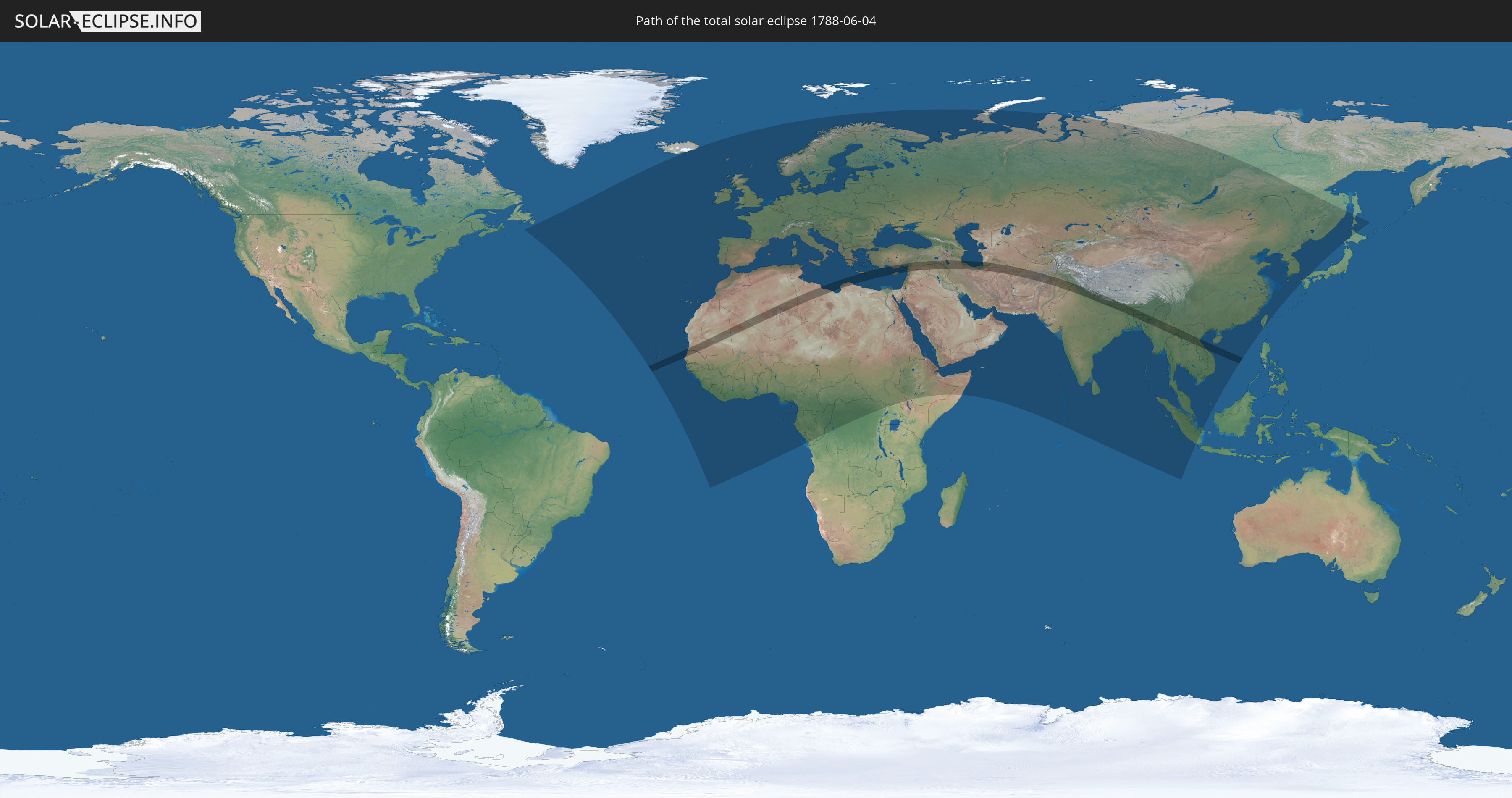
Die Sonnenfinsternis am 06/04/1788 kann man in 137 Ländern als partielle Sonnenfinsternis beobachten.
Der Finsternispfad verläuft durch 23 Länder. Nur in diesen Ländern ist sie als total Sonnenfinsternis zu sehen.
In den folgenden Ländern ist die Sonnenfinsternis total zu sehen
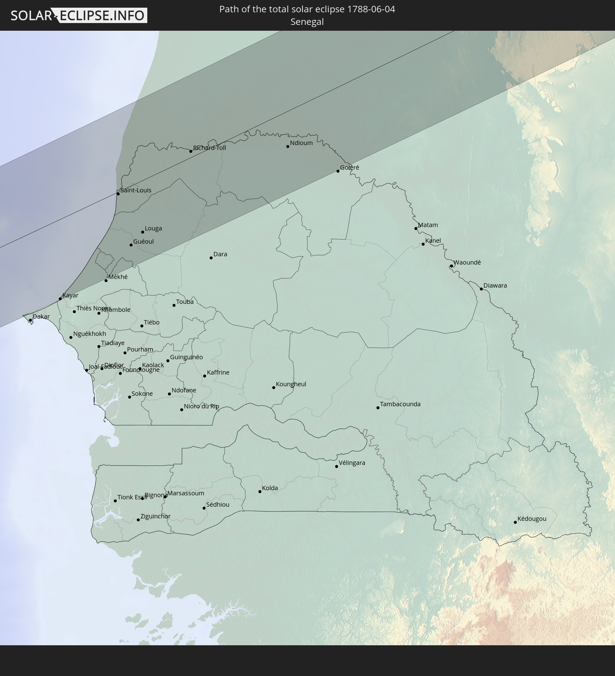 Senegal
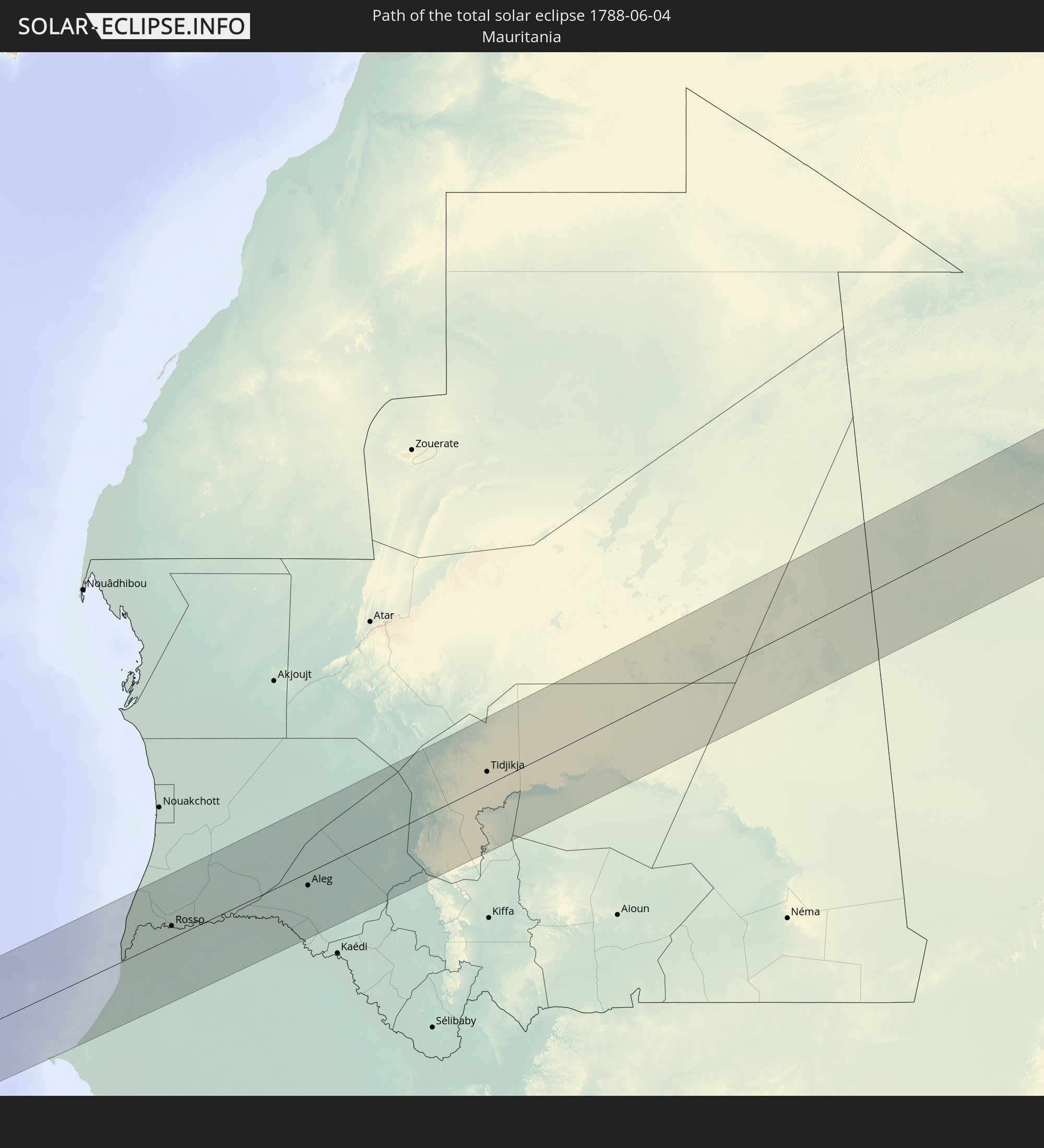 Mauritania
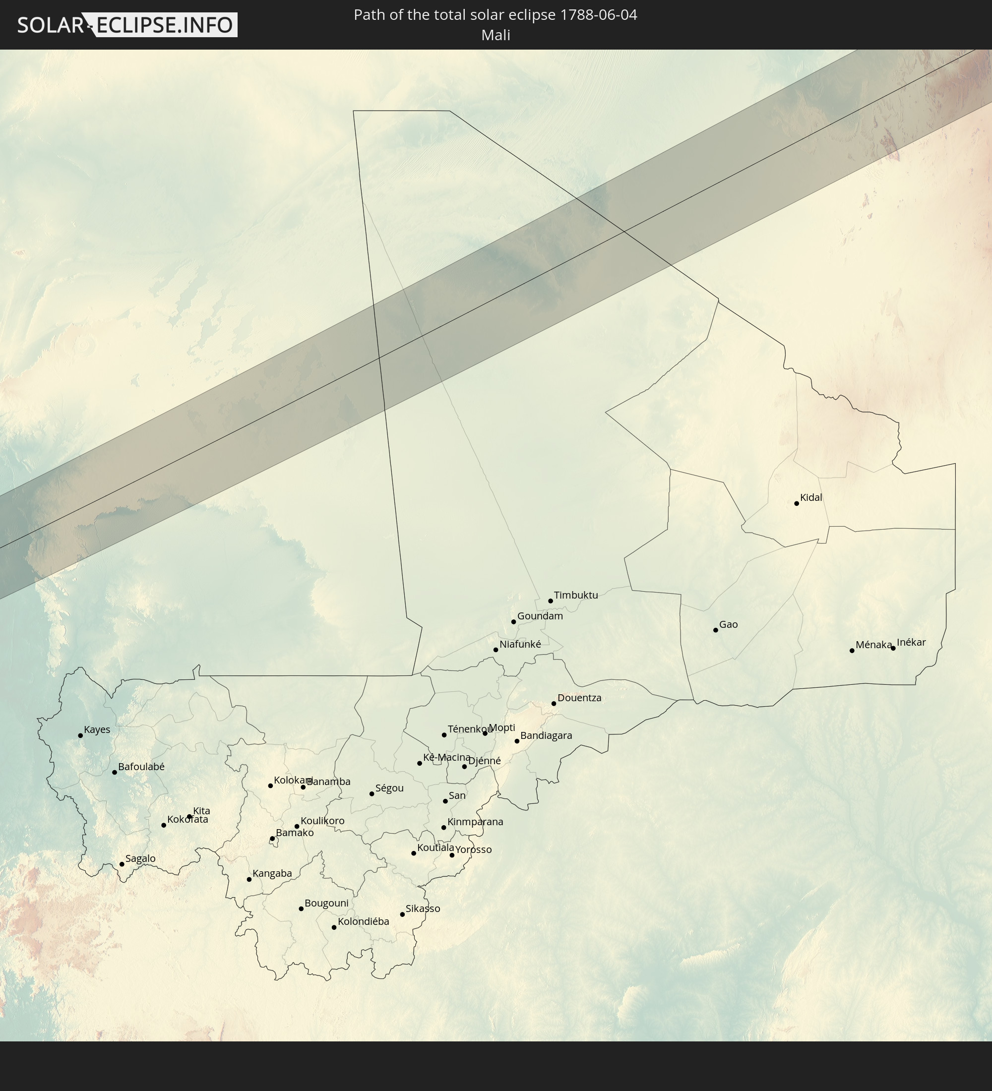 Mali
Mali
 Algeria
 Libya
Libya
 Greece
 Turkey
 Cyprus
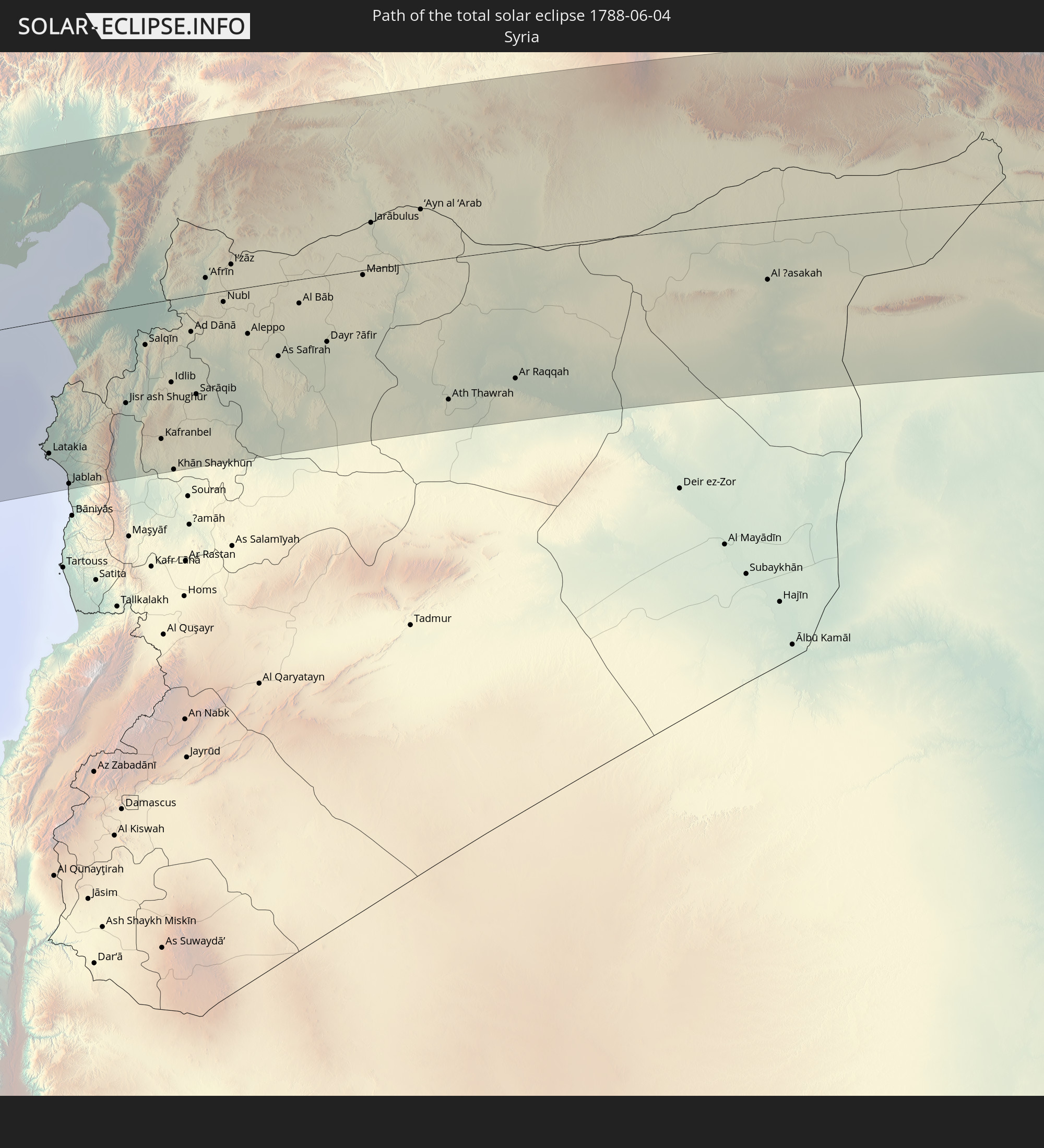 Syria
Syria
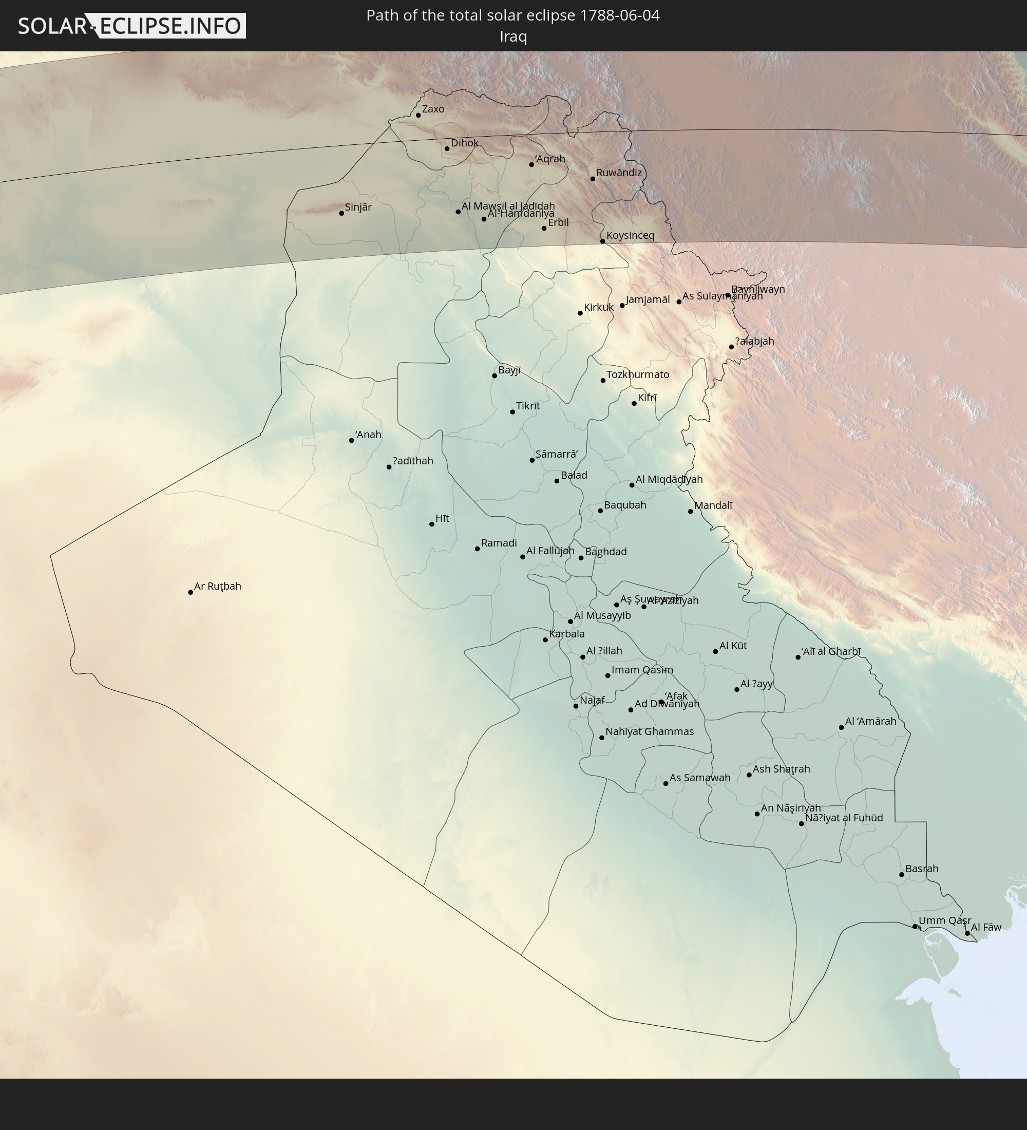 Iraq
Iraq
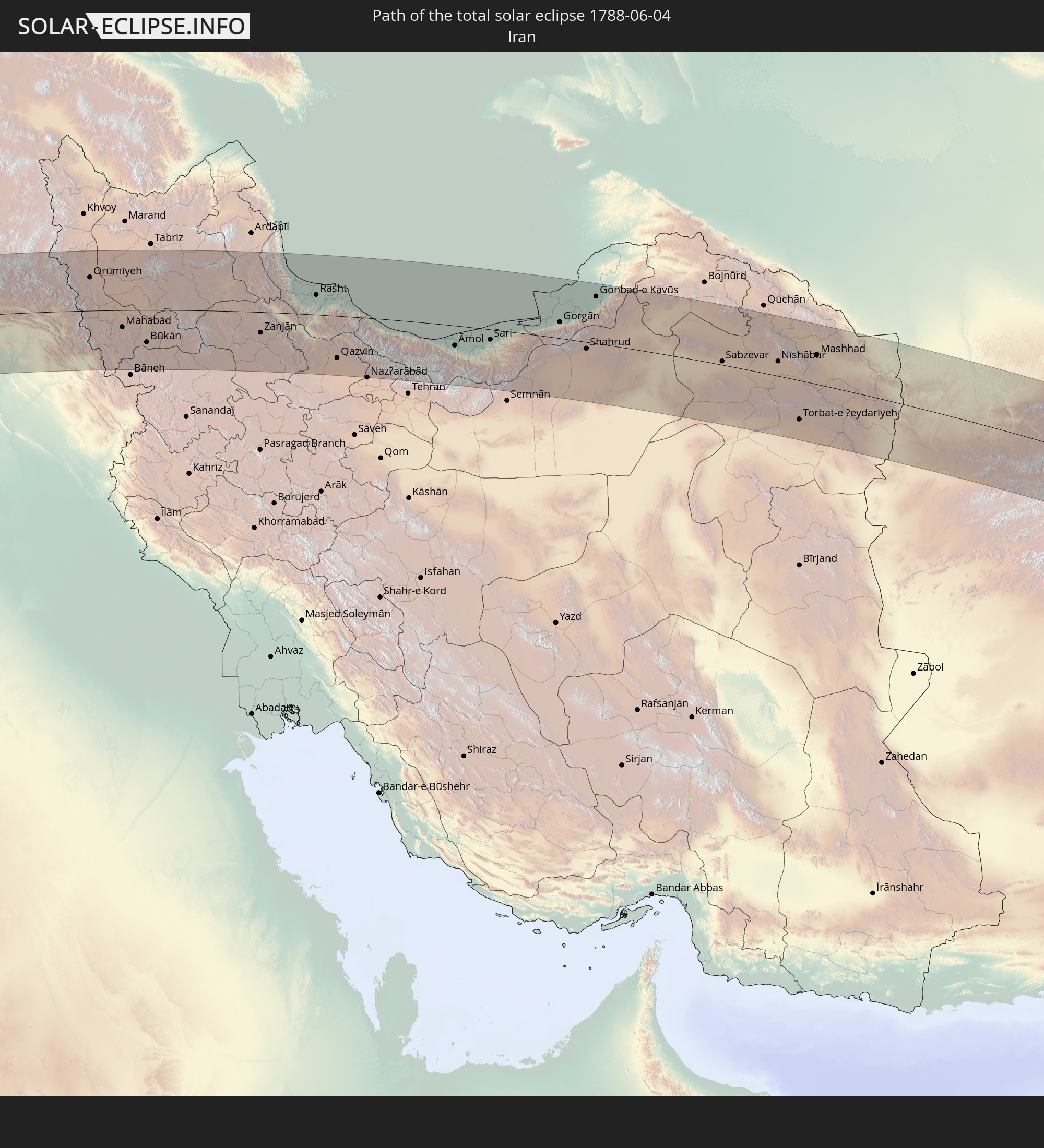 Iran
Iran
 Turkmenistan
 Afghanistan
 Pakistan
 India
India
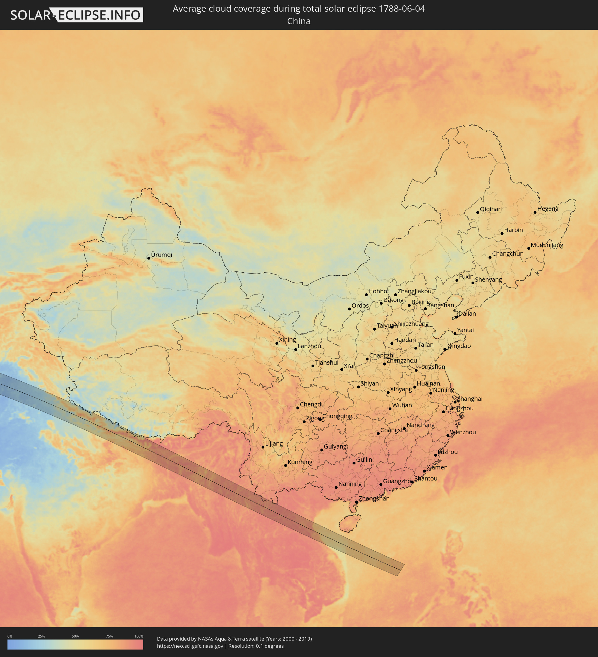
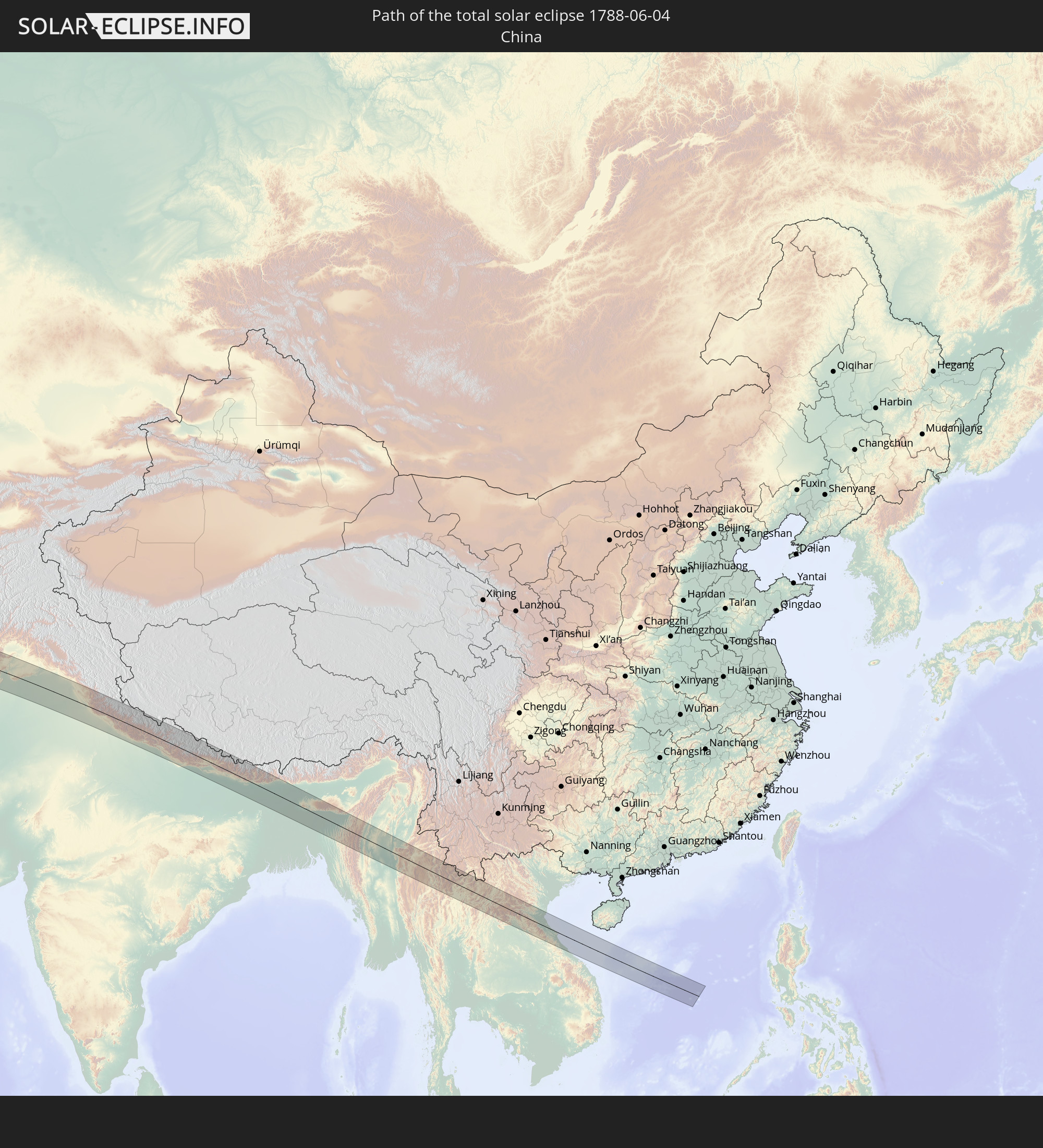 China
China
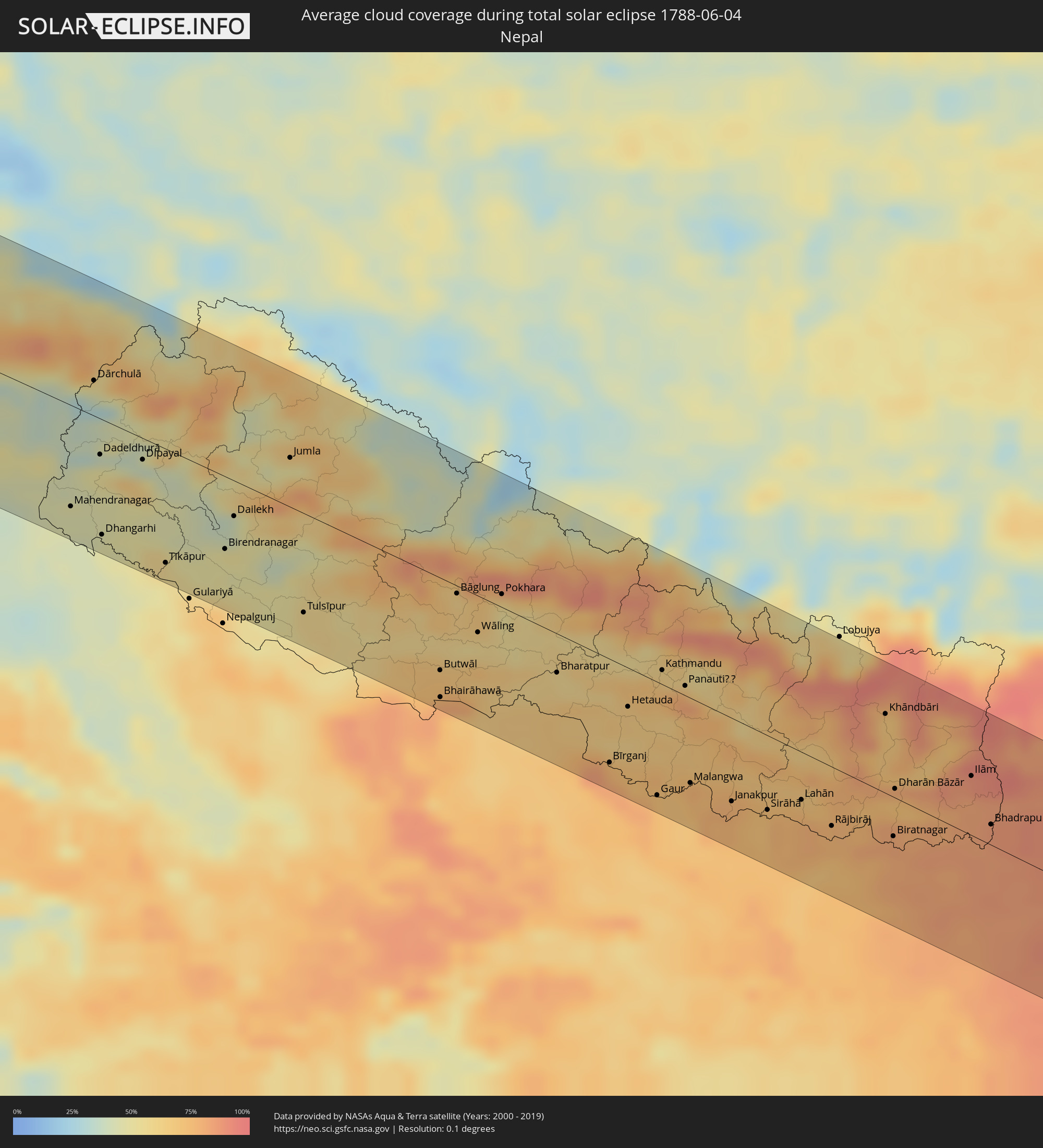
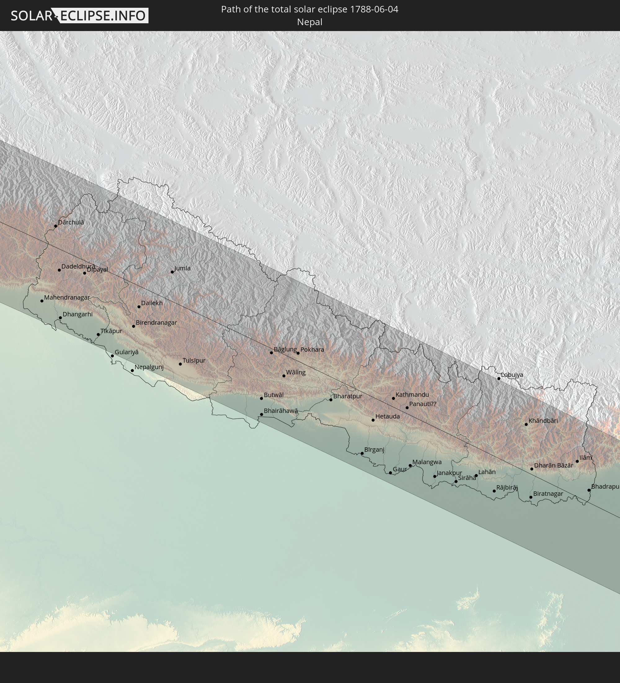 Nepal
Nepal
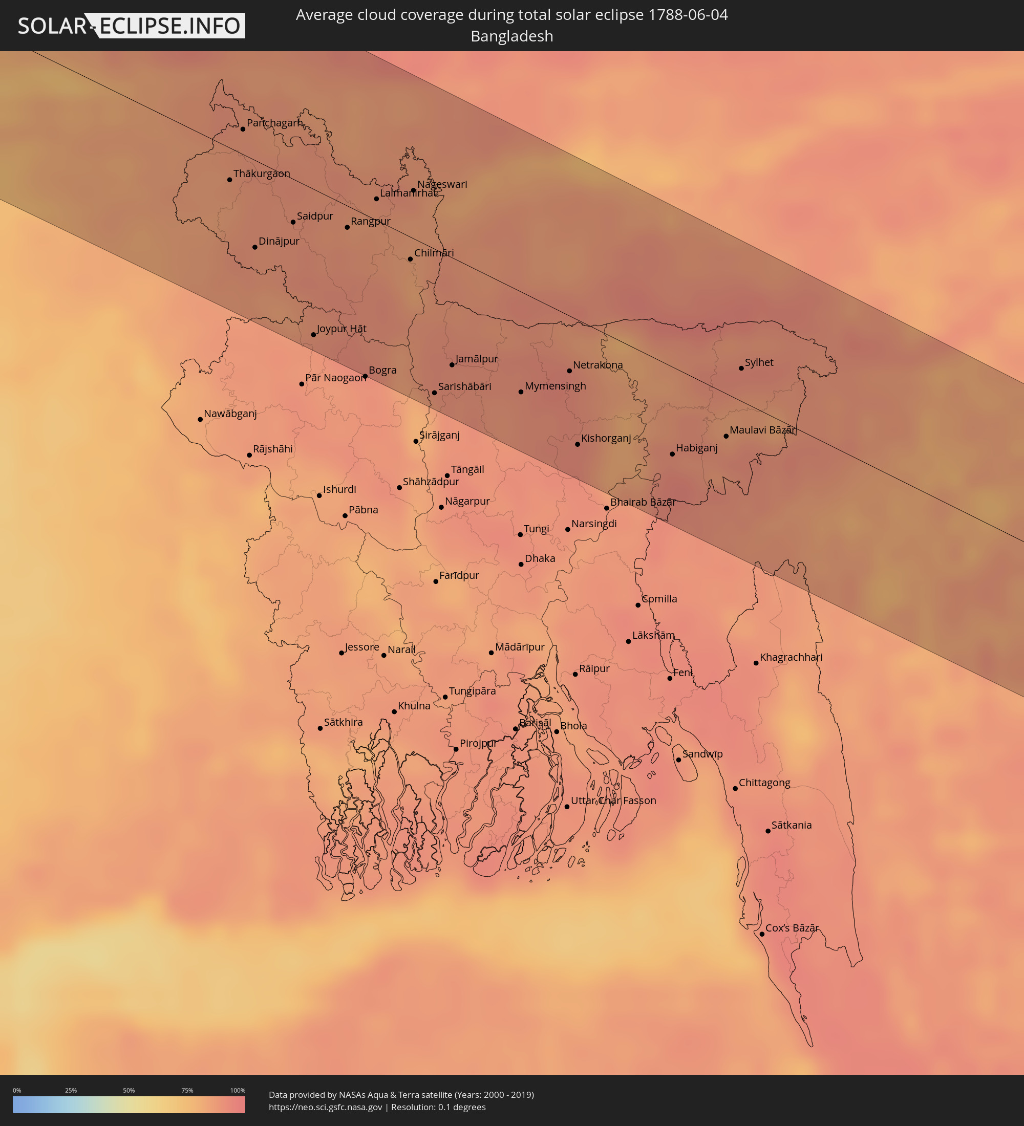
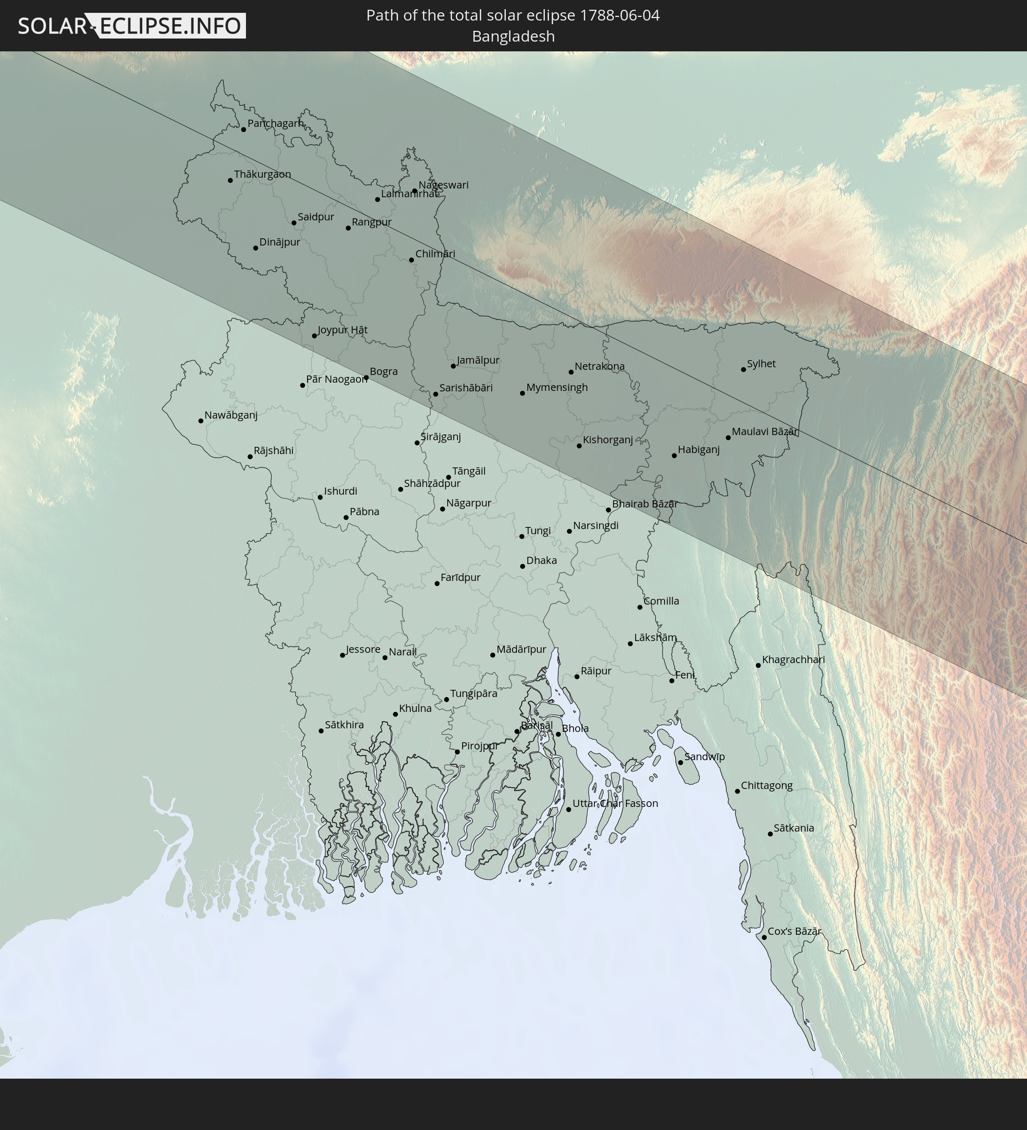 Bangladesh
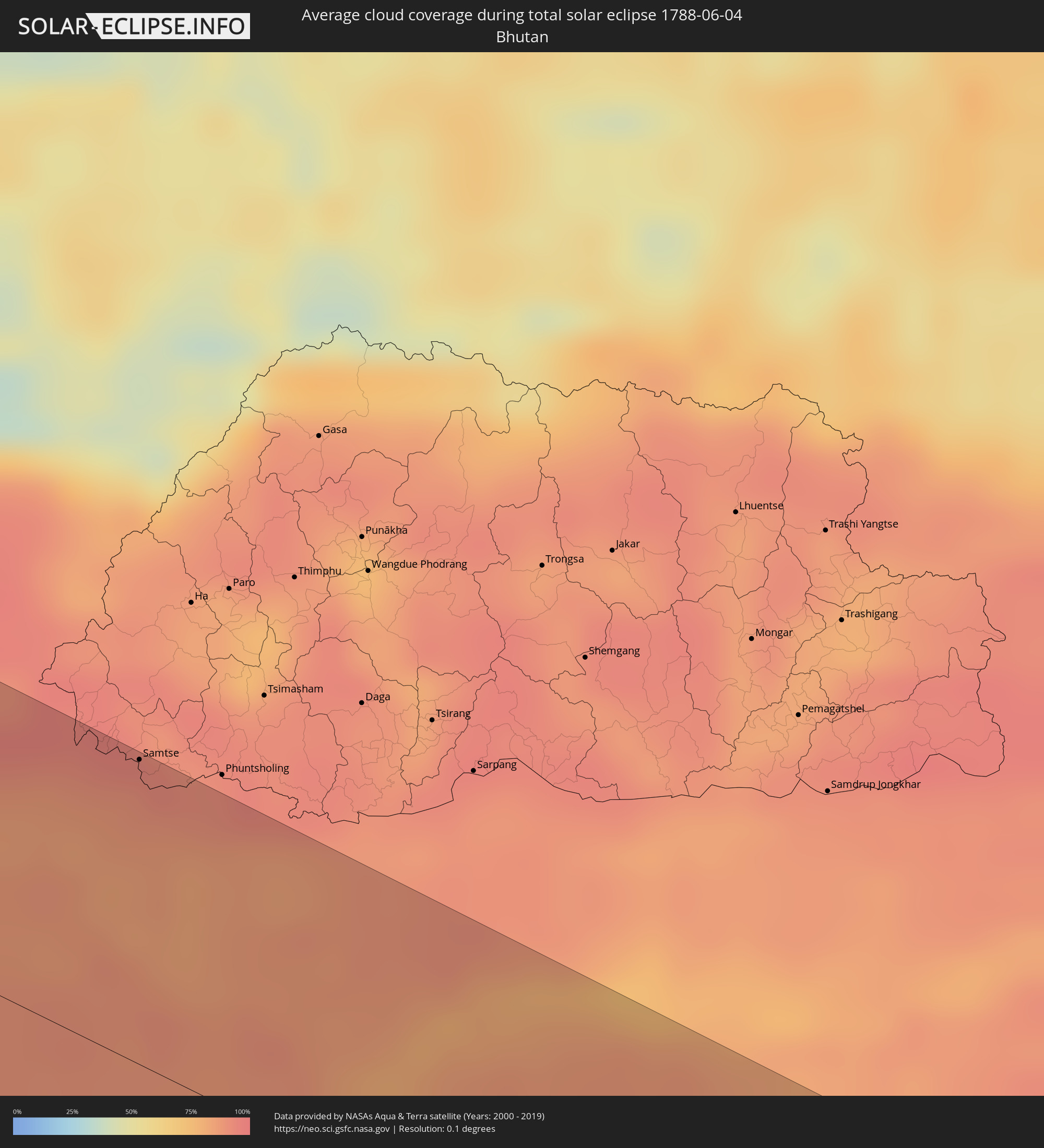
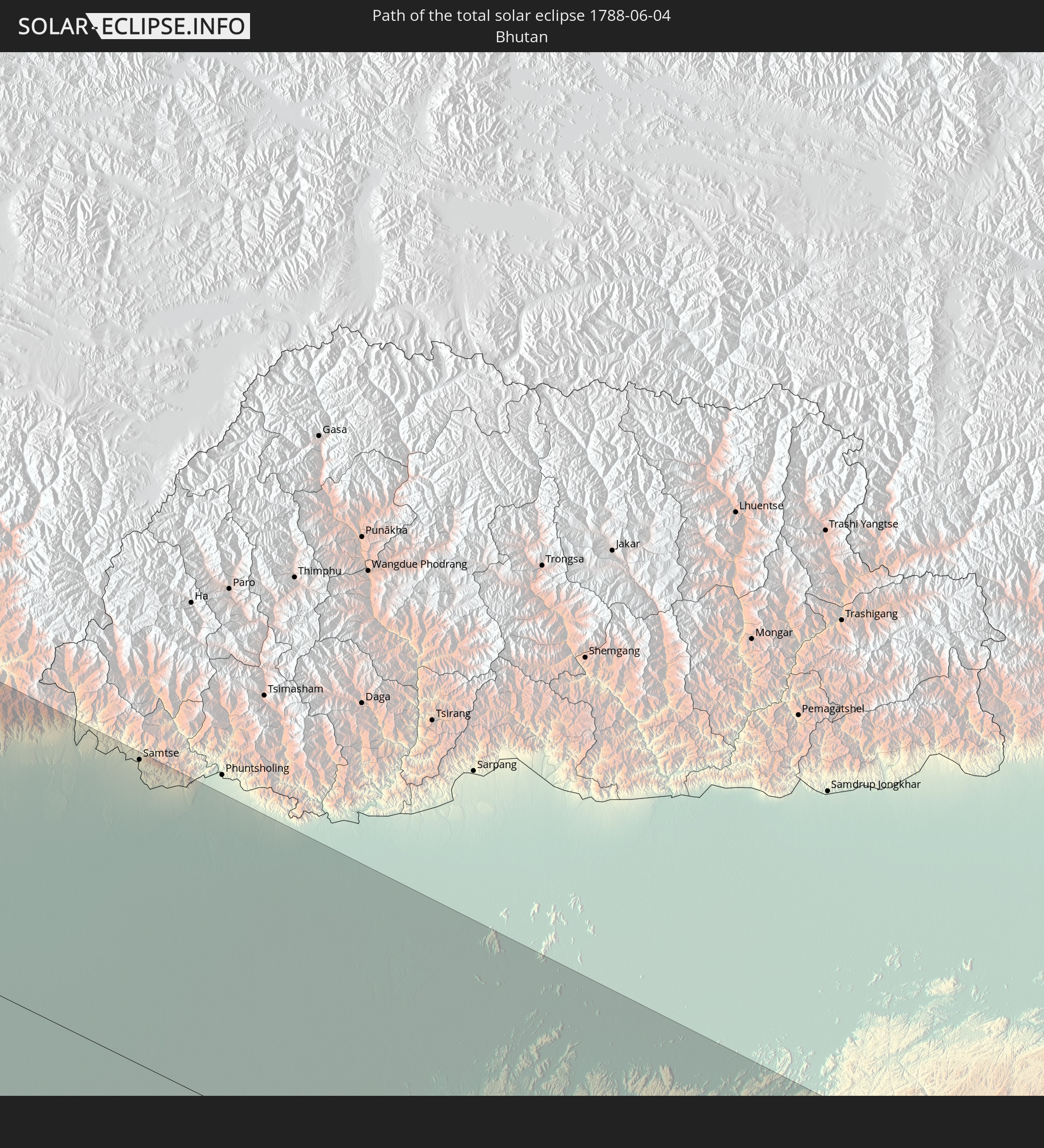 Bhutan
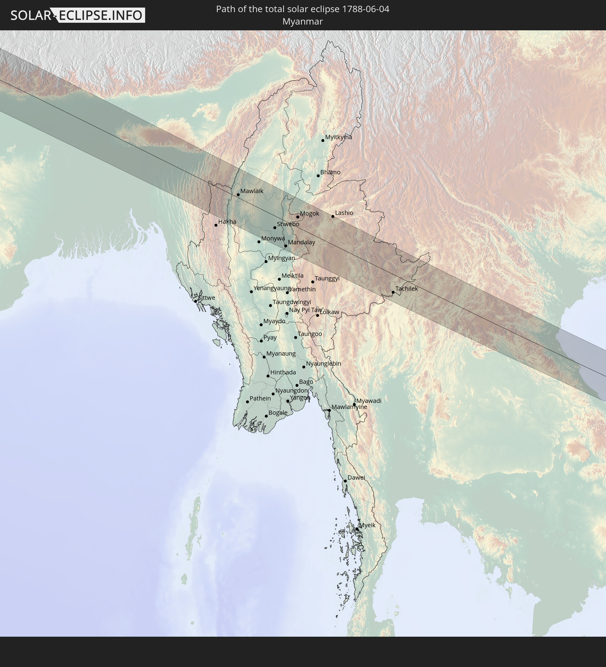 Myanmar
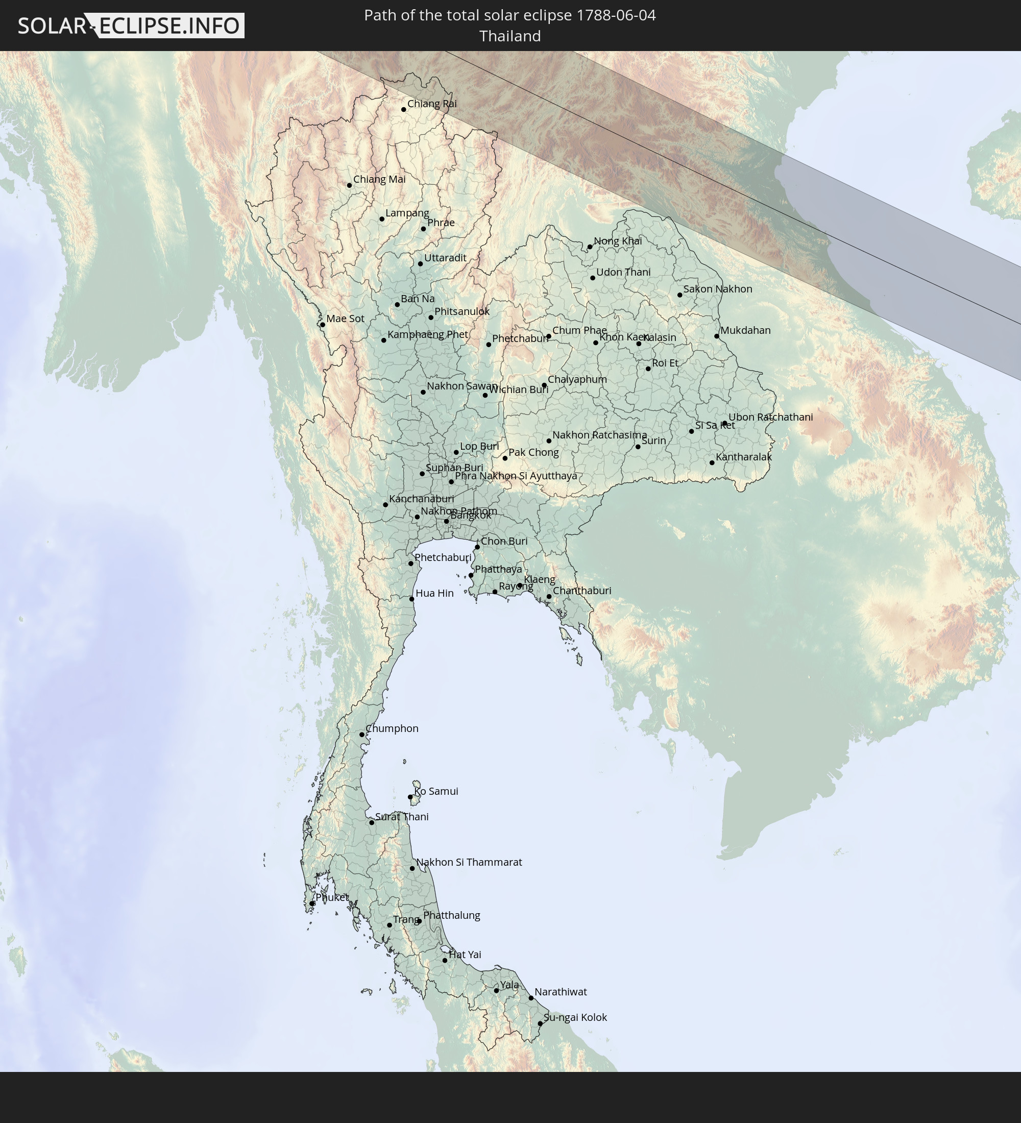 Thailand
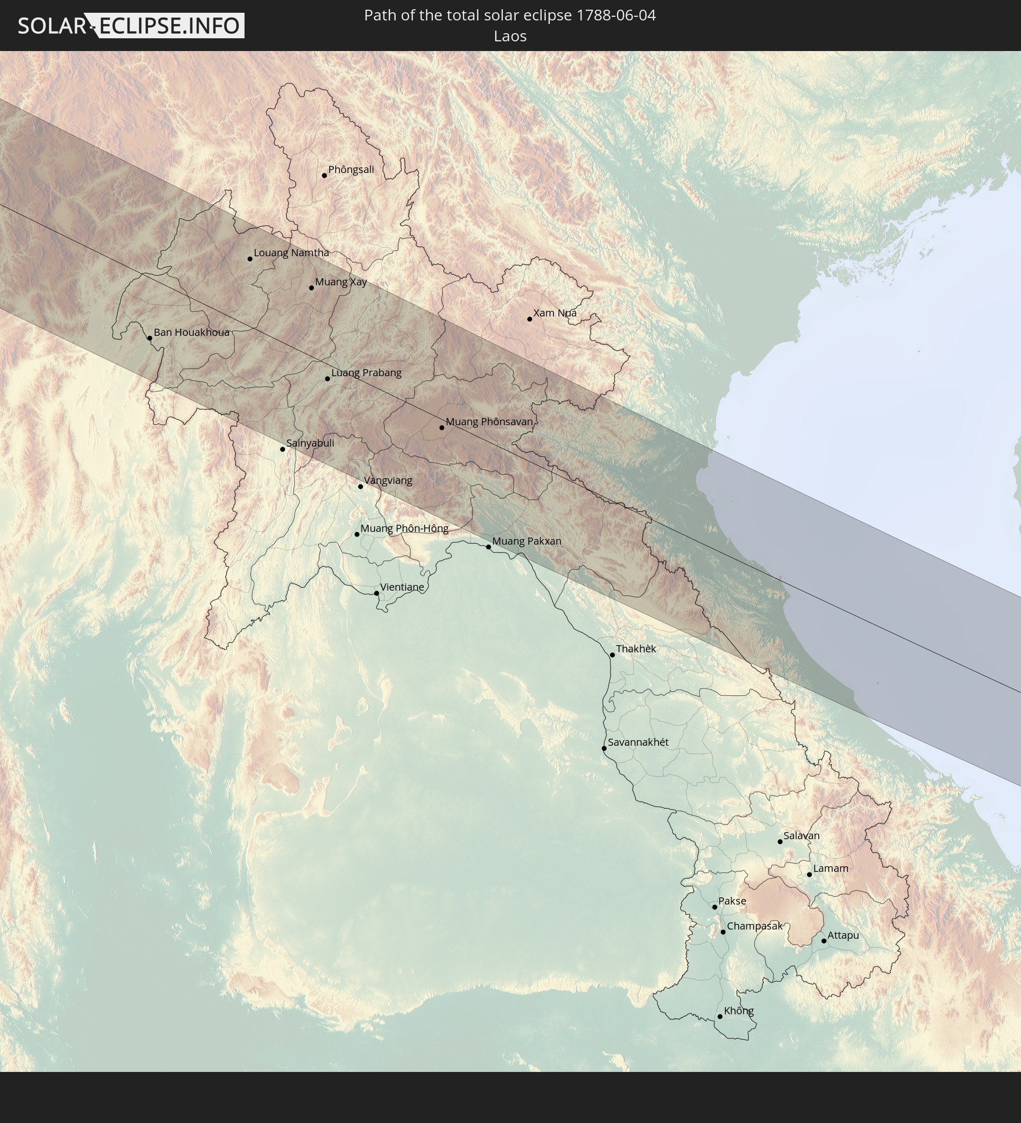 Laos
Laos
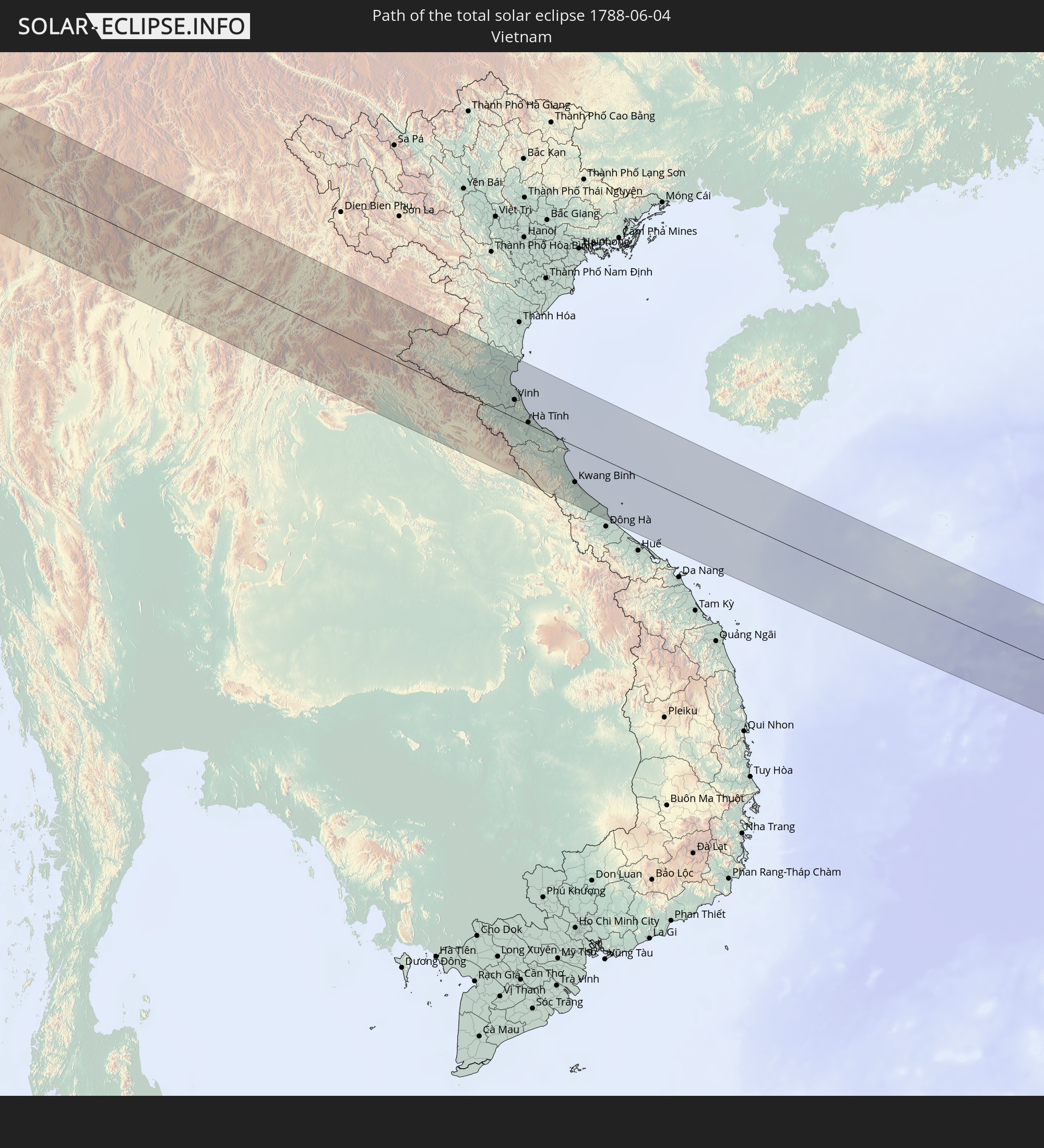 Vietnam
In den folgenden Ländern ist die Sonnenfinsternis partiell zu sehen
 Russia
 Portugal
 Cabo Verde
 Iceland
 Spain
Spain
 Senegal
 Mauritania
 The Gambia
 Guinea-Bissau
 Guinea
 Saint Helena, Ascension and Tristan da Cunha
 Sierra Leone
 Morocco
 Mali
Mali
 Liberia
 Republic of Ireland
 Algeria
 United Kingdom
 Ivory Coast
 Faroe Islands
 Burkina Faso
 Gibraltar
 France
 Isle of Man
 Ghana
Ghana
 Guernsey
 Jersey
 Togo
Togo
 Niger
Niger
 Benin
Benin
 Andorra
 Belgium
 Nigeria
 Netherlands
 Norway
 Equatorial Guinea
 Luxembourg
 Germany
 Switzerland
 São Tomé and Príncipe
 Italy
Italy
 Monaco
 Tunisia
 Denmark
 Cameroon
 Gabon
Gabon
 Libya
Libya
 Liechtenstein
 Austria
 Sweden
 Republic of the Congo
 Angola
 Czechia
 Democratic Republic of the Congo
 San Marino
 Vatican City
 Slovenia
 Chad
Chad
 Croatia
 Poland
 Malta
Malta
 Central African Republic
 Bosnia and Herzegovina
 Hungary
 Slovakia
 Montenegro
 Serbia
 Albania
 Åland Islands
 Greece
 Romania
 Republic of Macedonia
 Finland
 Lithuania
 Latvia
 Estonia
 Sudan
Sudan
 Ukraine
 Bulgaria
 Belarus
 Egypt
Egypt
 Turkey
 Moldova
 Uganda
 Cyprus
 Ethiopia
 Kenya
Kenya
 State of Palestine
 Israel
 Saudi Arabia
 Jordan
 Lebanon
 Syria
Syria
 Eritrea
 Iraq
Iraq
 Georgia
 Somalia
 Djibouti
 Yemen
Yemen
 Armenia
 Iran
Iran
 Azerbaijan
 Kazakhstan
 Kuwait
 Bahrain
 Qatar
Qatar
 United Arab Emirates
 Oman
Oman
 Turkmenistan
 Uzbekistan
 Afghanistan
 Pakistan
 Tajikistan
 India
India
 Kyrgyzstan
 Maldives
 China
China
 Sri Lanka
 Nepal
Nepal
 Mongolia
 Bangladesh
 Bhutan
 Myanmar
 Indonesia
 Cocos Islands
 Thailand
 Malaysia
 Laos
Laos
 Vietnam
 Cambodia
 Singapore
 Macau
Macau
 Hong Kong
 Taiwan
 Japan
Japan
 North Korea
 South Korea
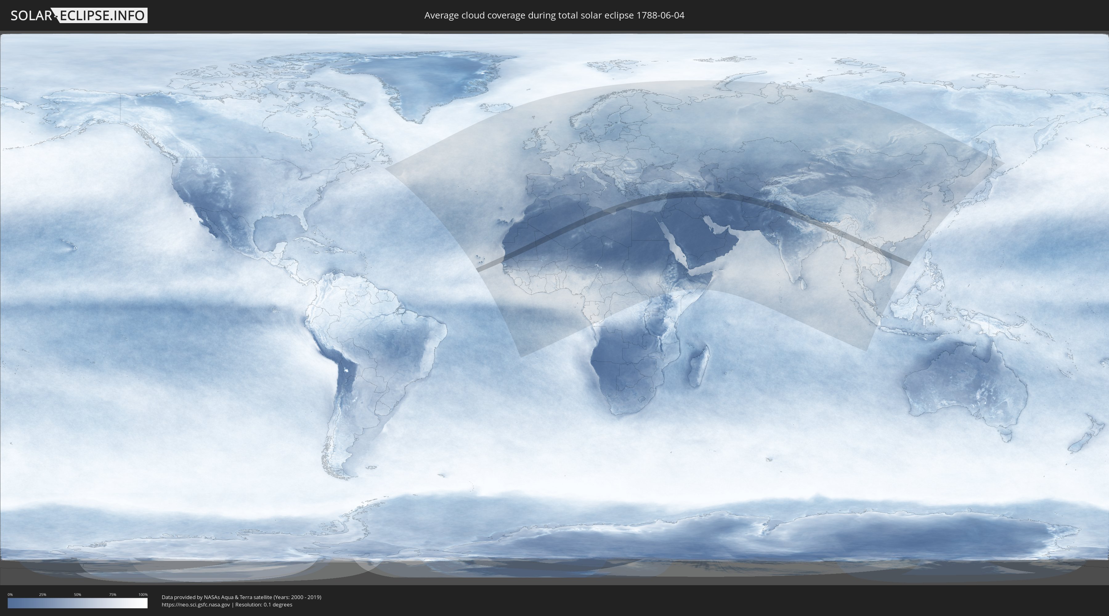
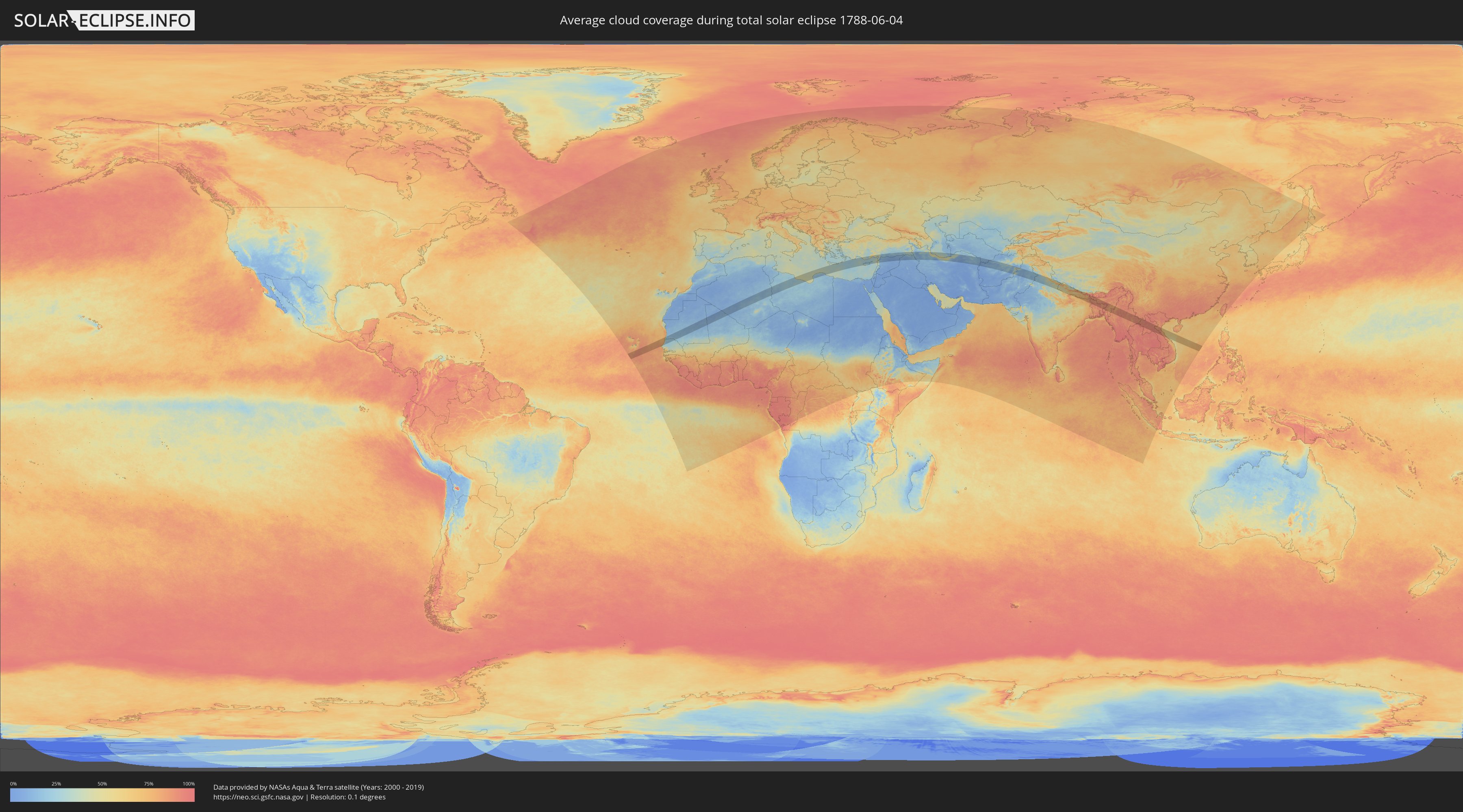
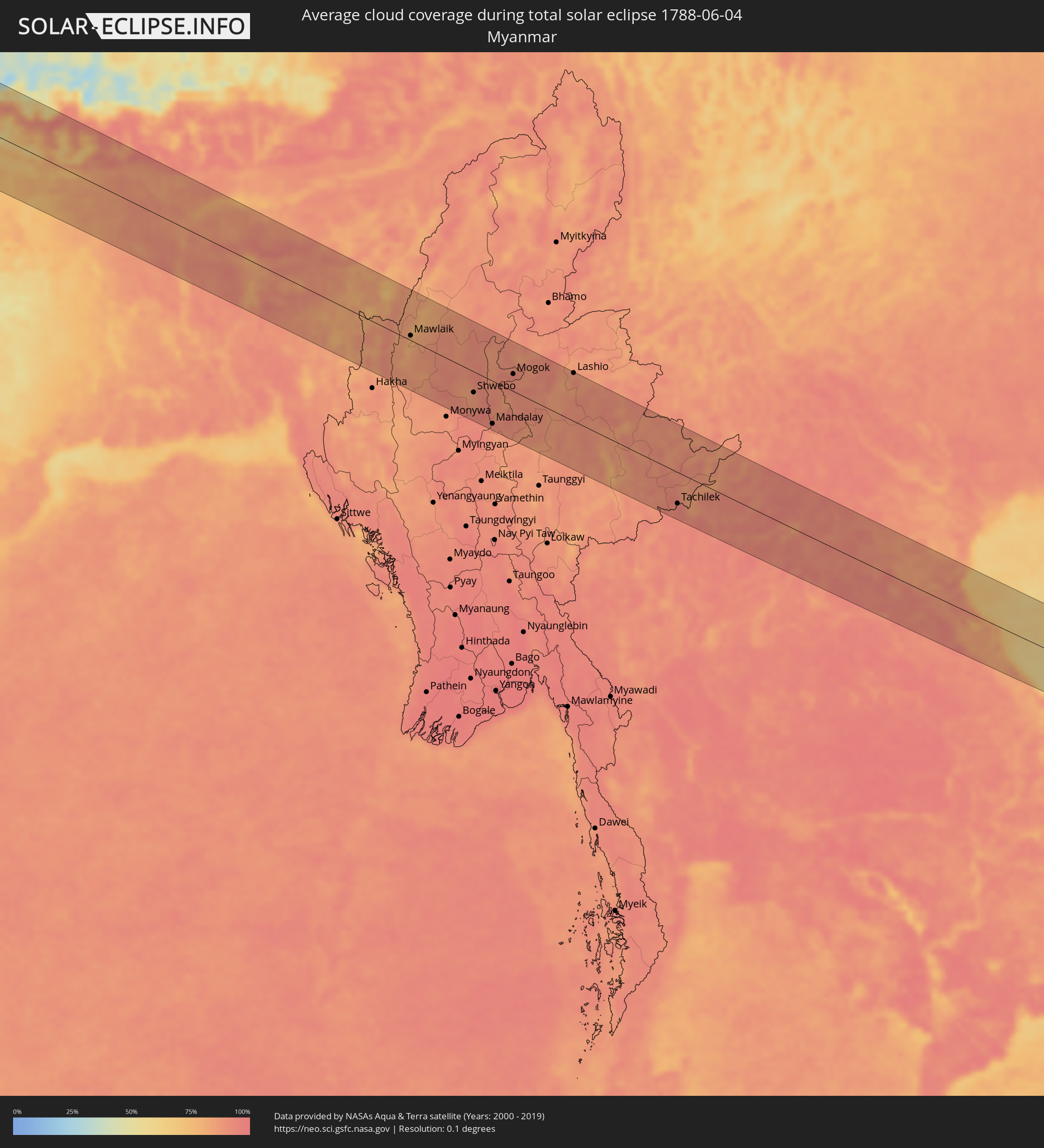
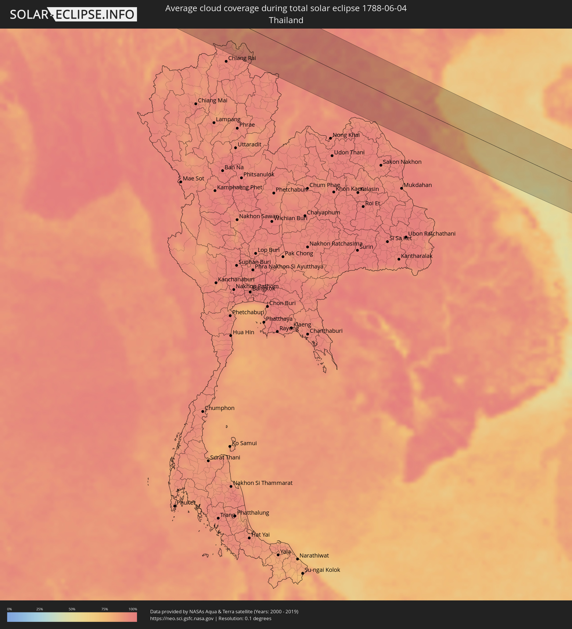
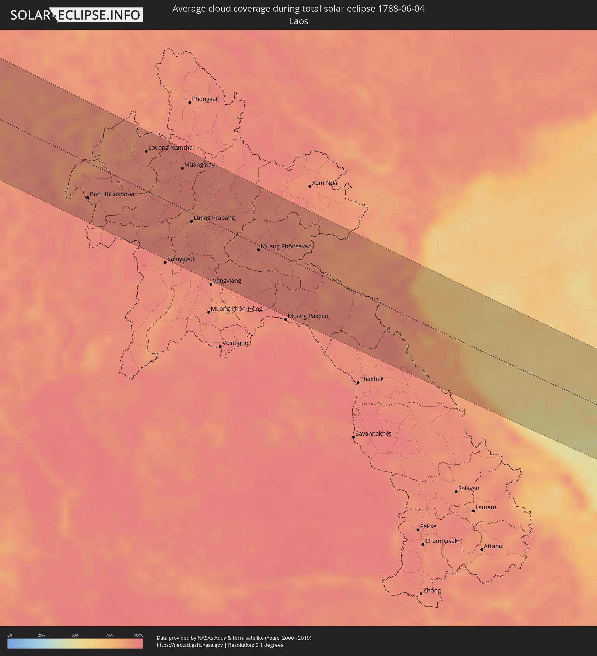
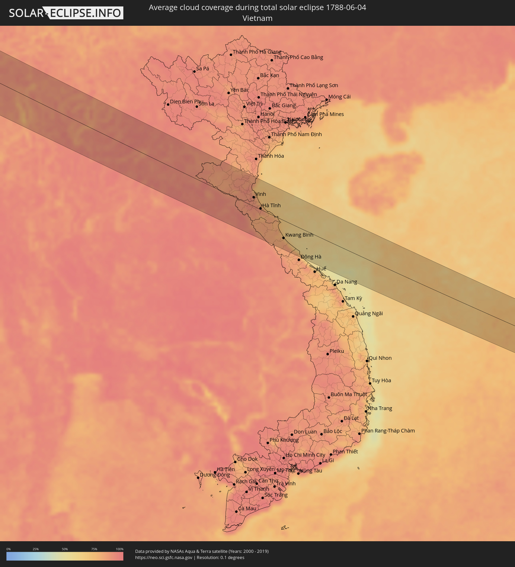
How will be the weather during the total solar eclipse on 06/04/1788?
Where is the best place to see the total solar eclipse of 06/04/1788?
The following maps show the average cloud coverage for the day of the total solar eclipse.
With the help of these maps, it is possible to find the place along the eclipse path, which has the best
chance of a cloudless sky.
Nevertheless, you should consider local circumstances and inform about the weather of your chosen
observation site.
The data is provided by NASAs satellites
AQUA and TERRA.
The cloud maps are averaged over a period of 19 years (2000 - 2019).
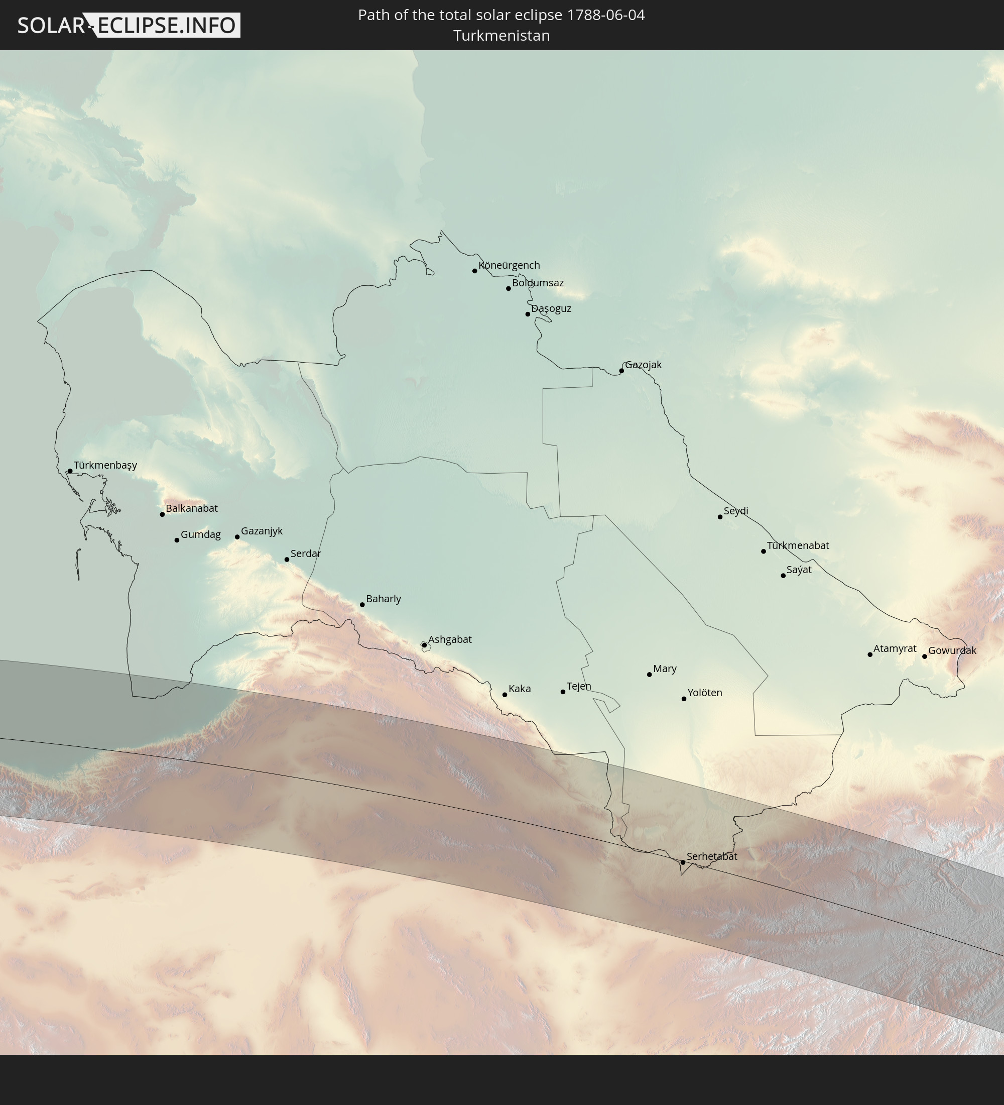
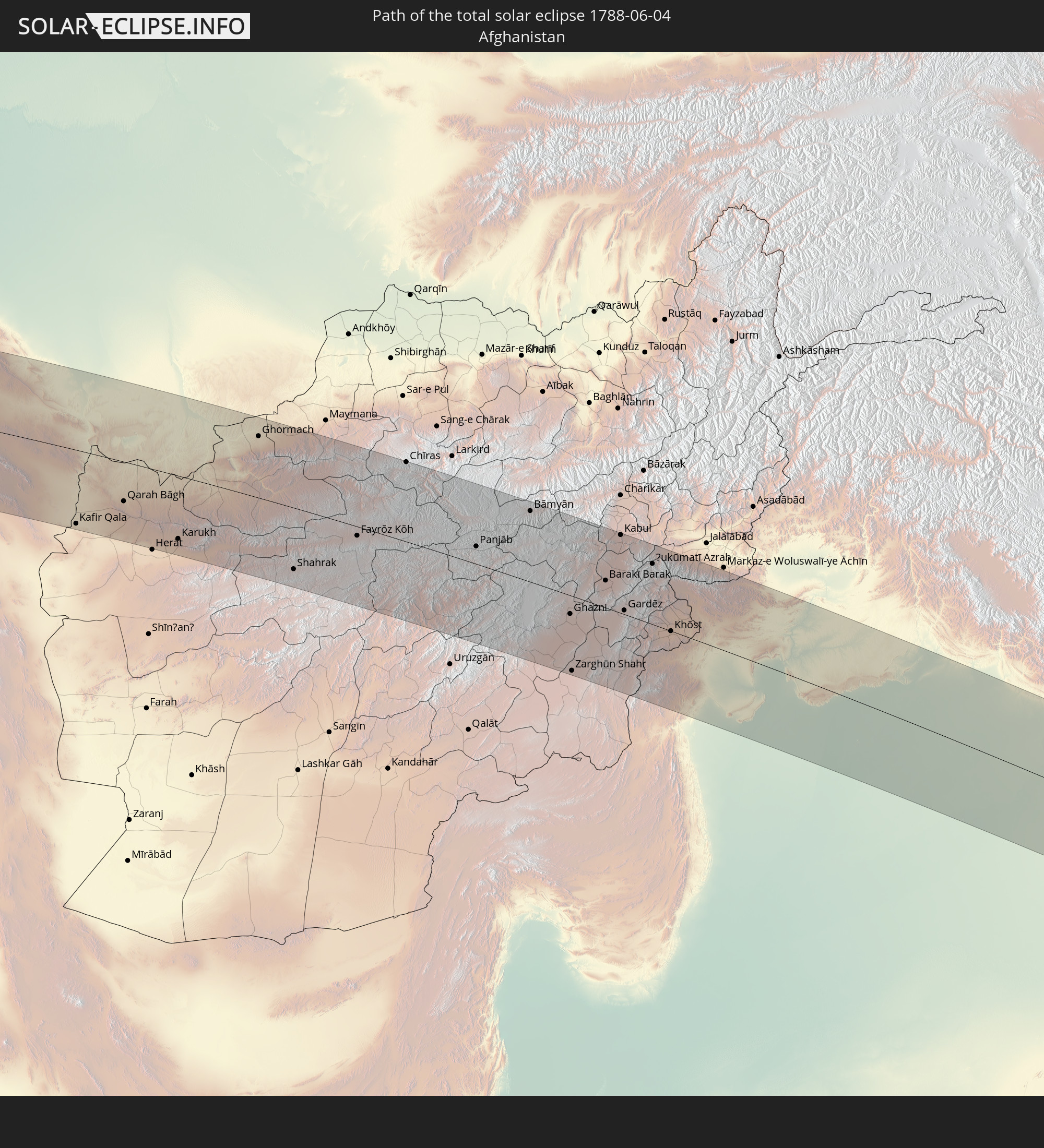
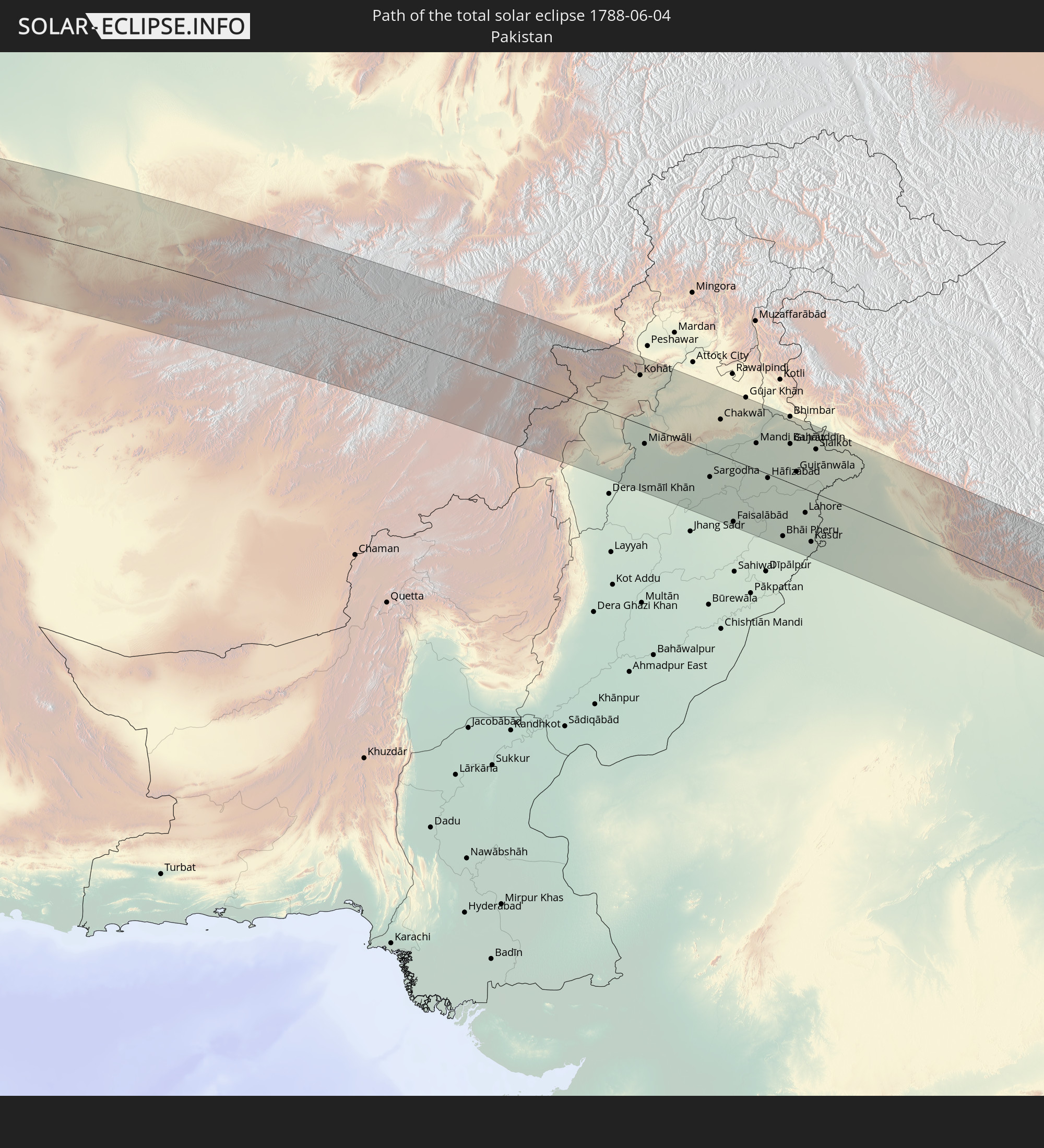
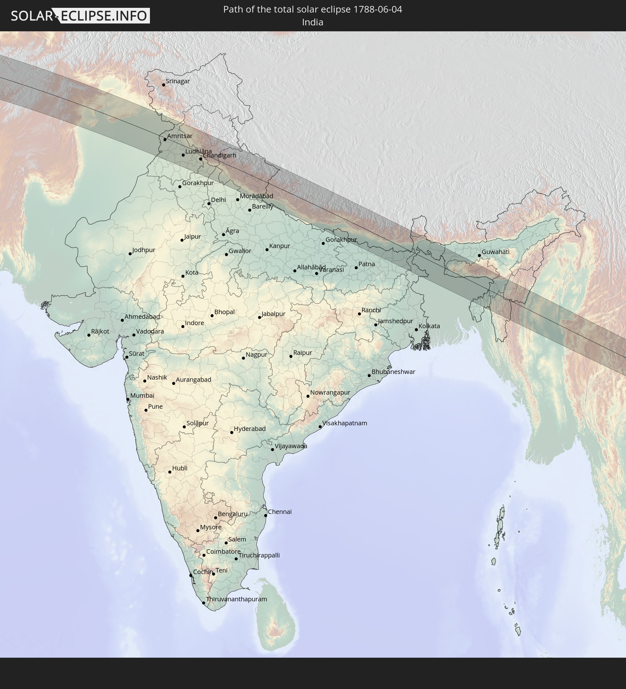
Detailed country maps
 Senegal
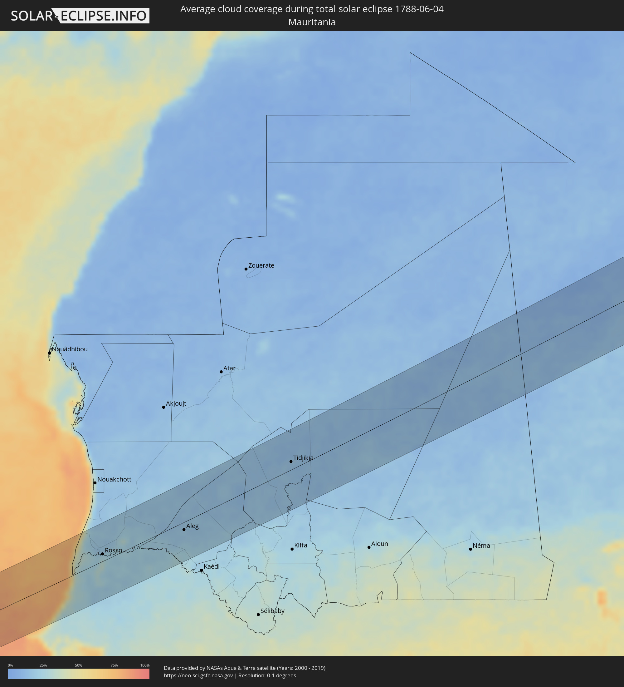 Mauritania
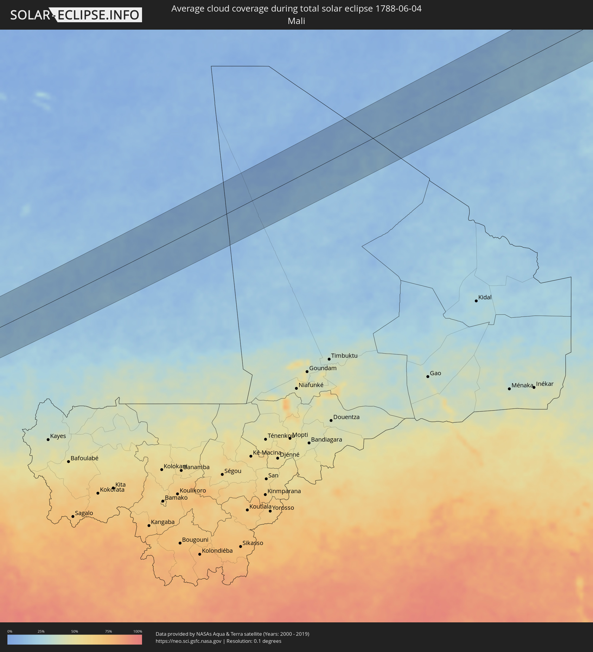 Mali
Mali
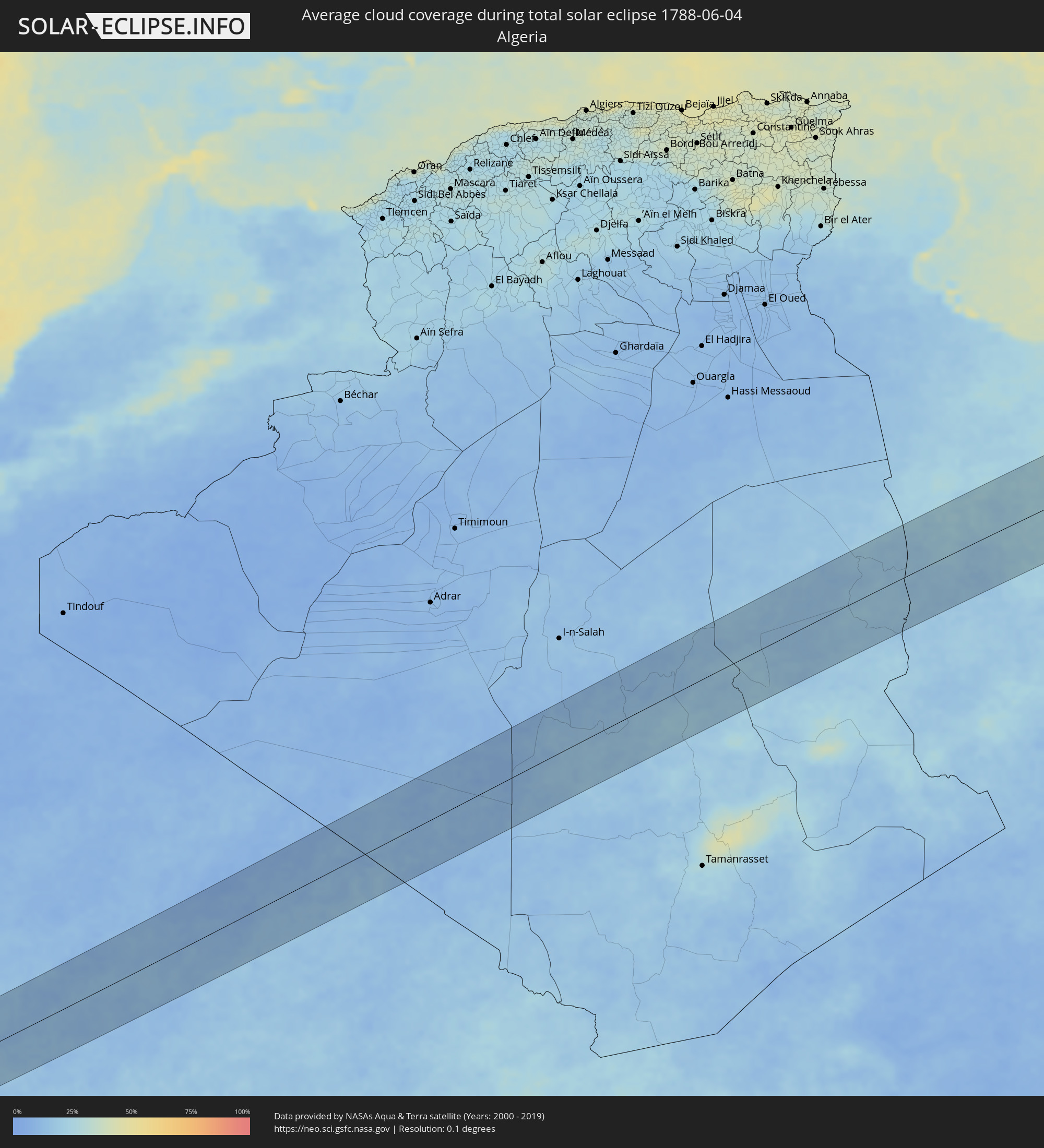 Algeria
 Libya
Libya
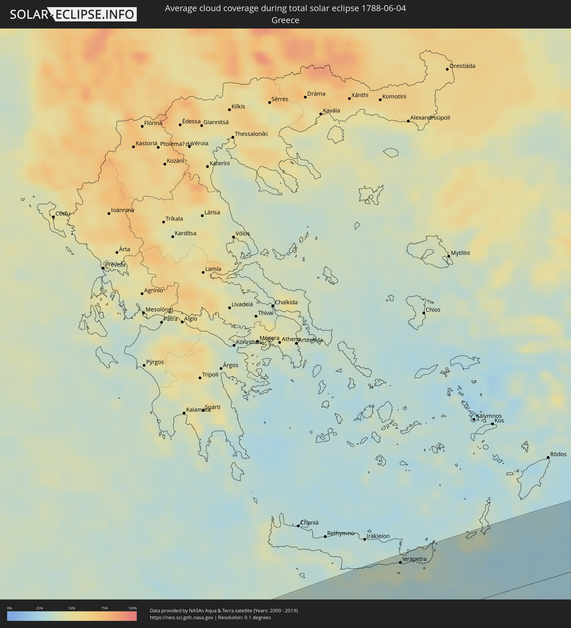 Greece
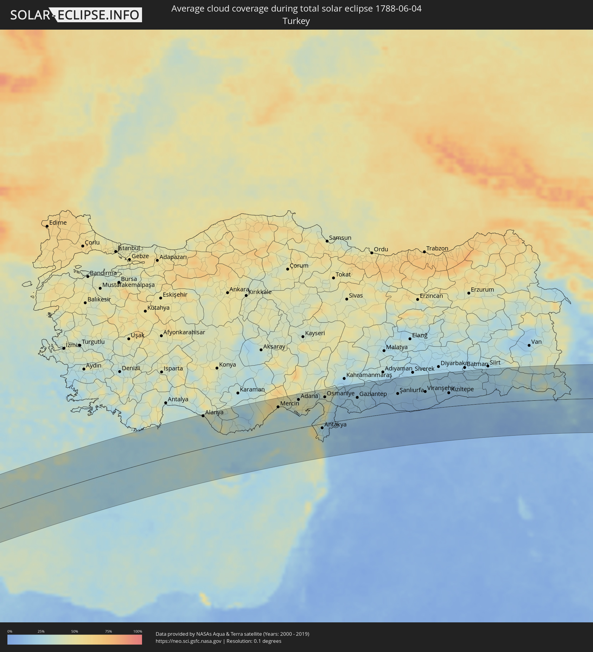 Turkey
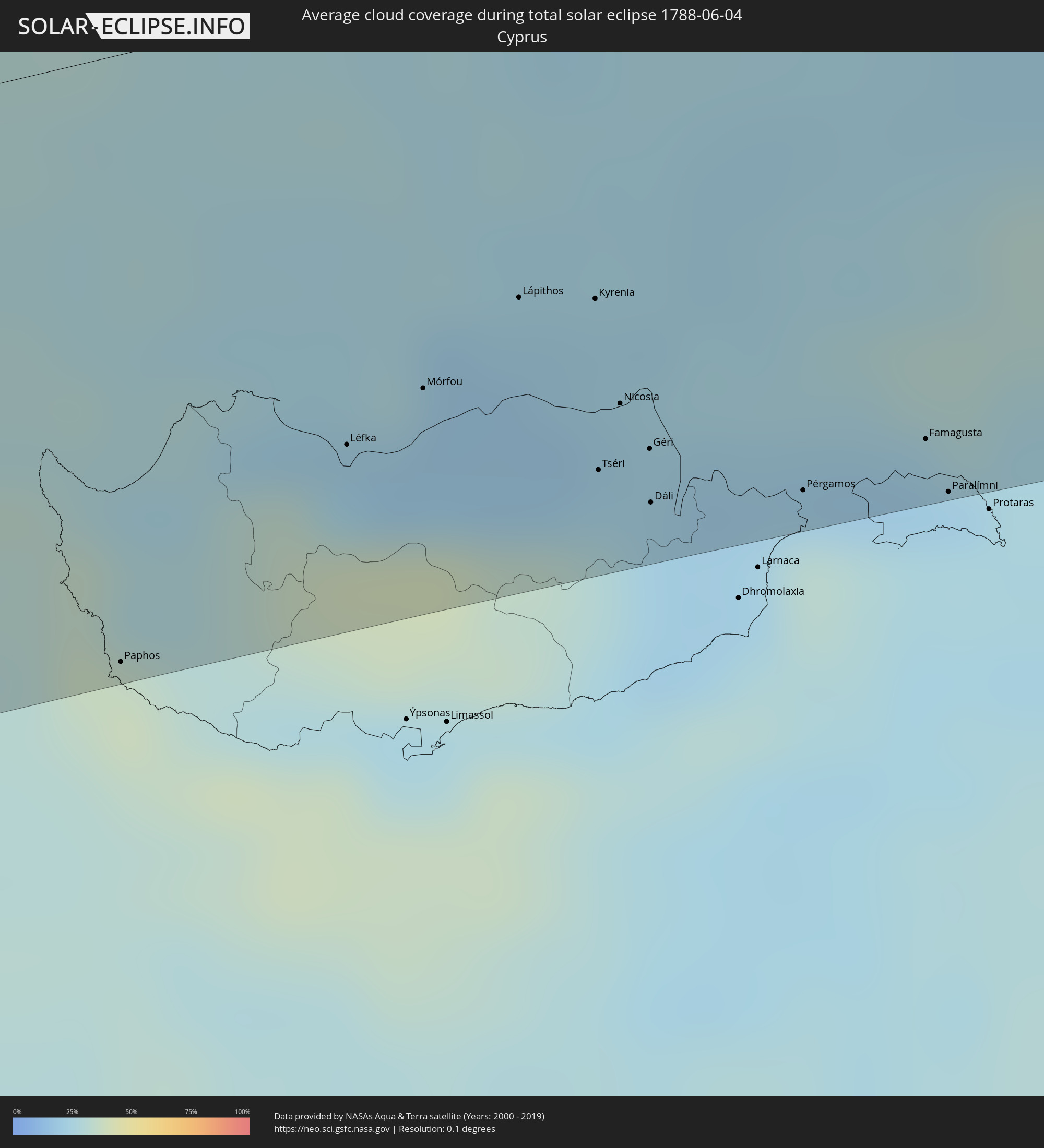 Cyprus
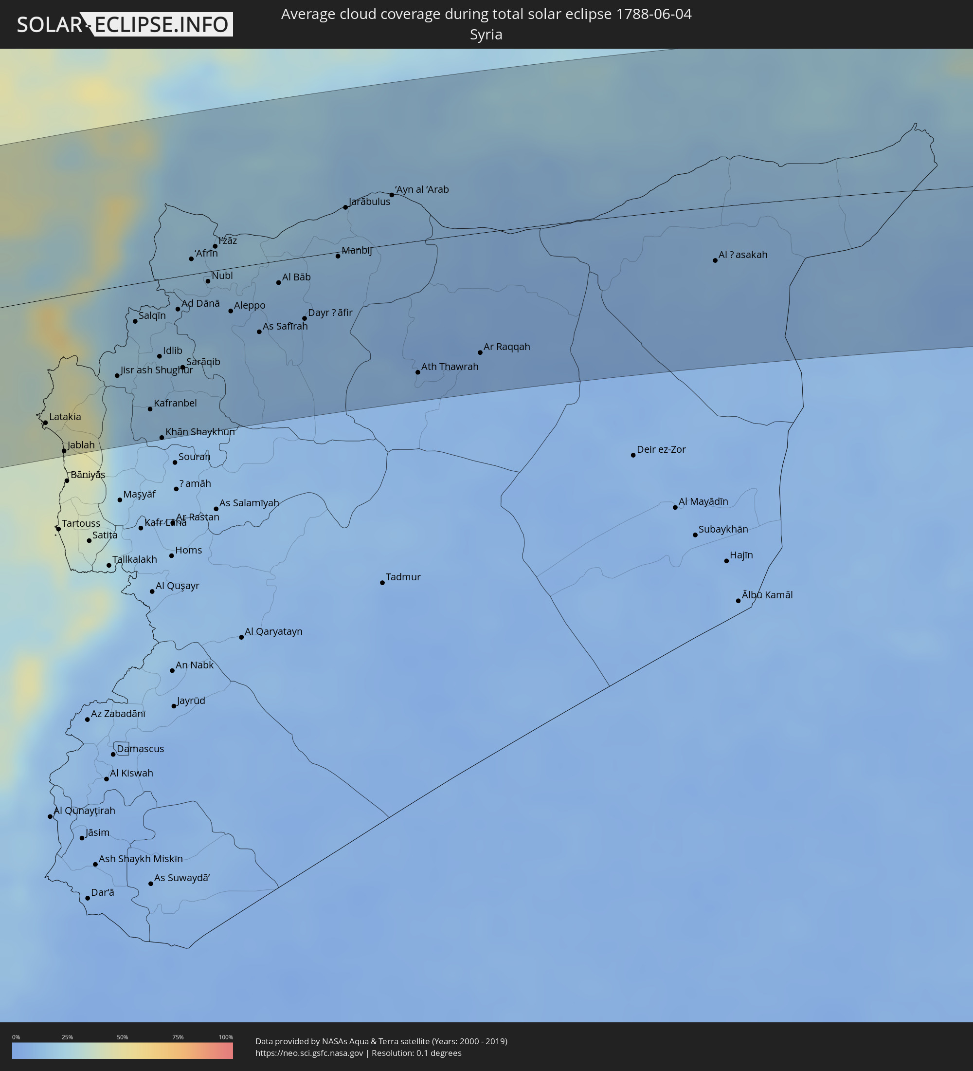 Syria
Syria
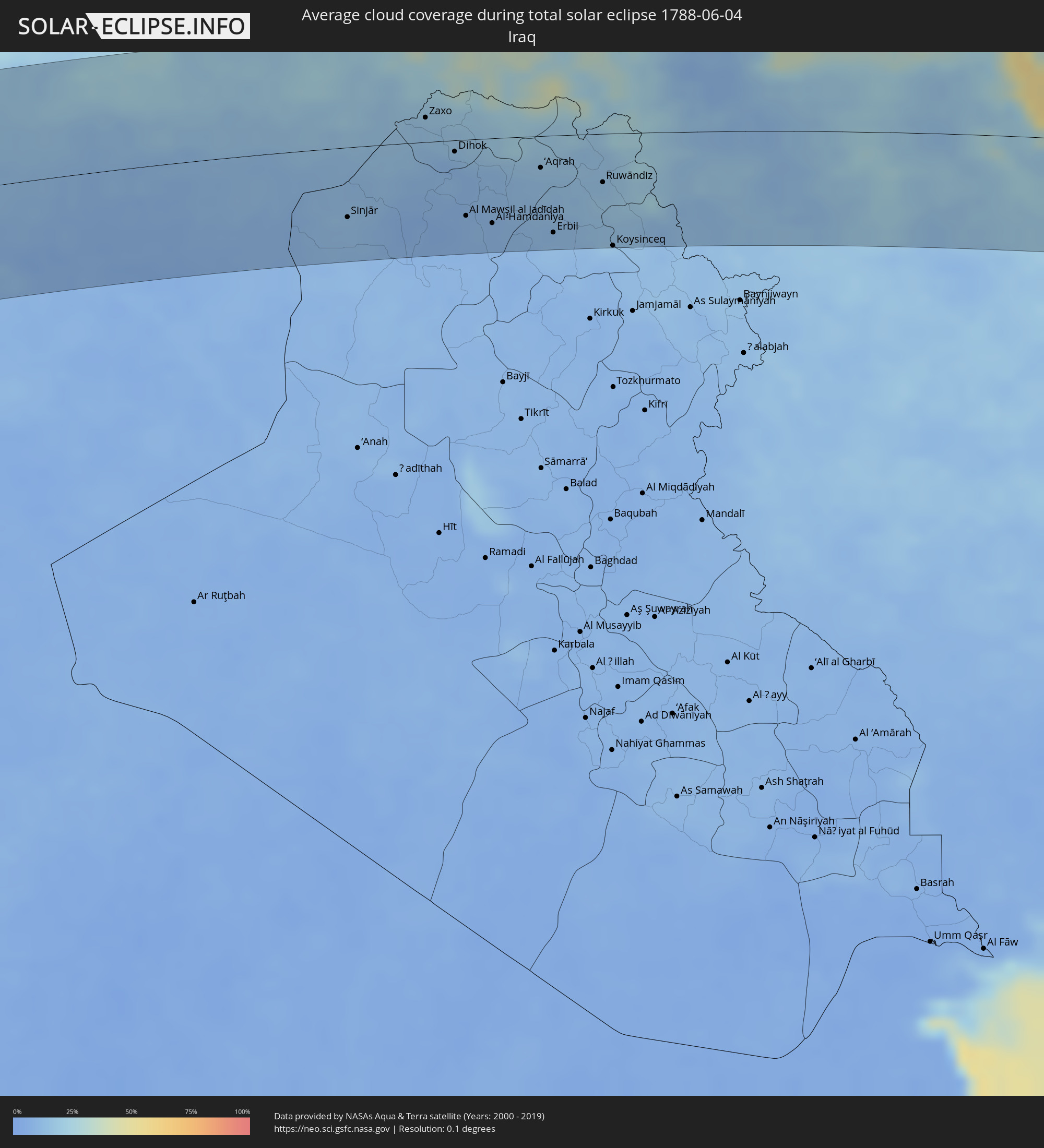 Iraq
Iraq
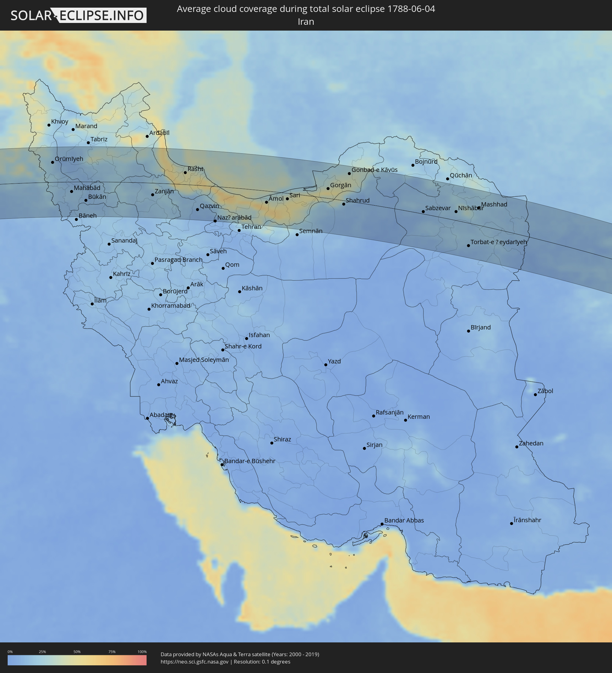 Iran
Iran
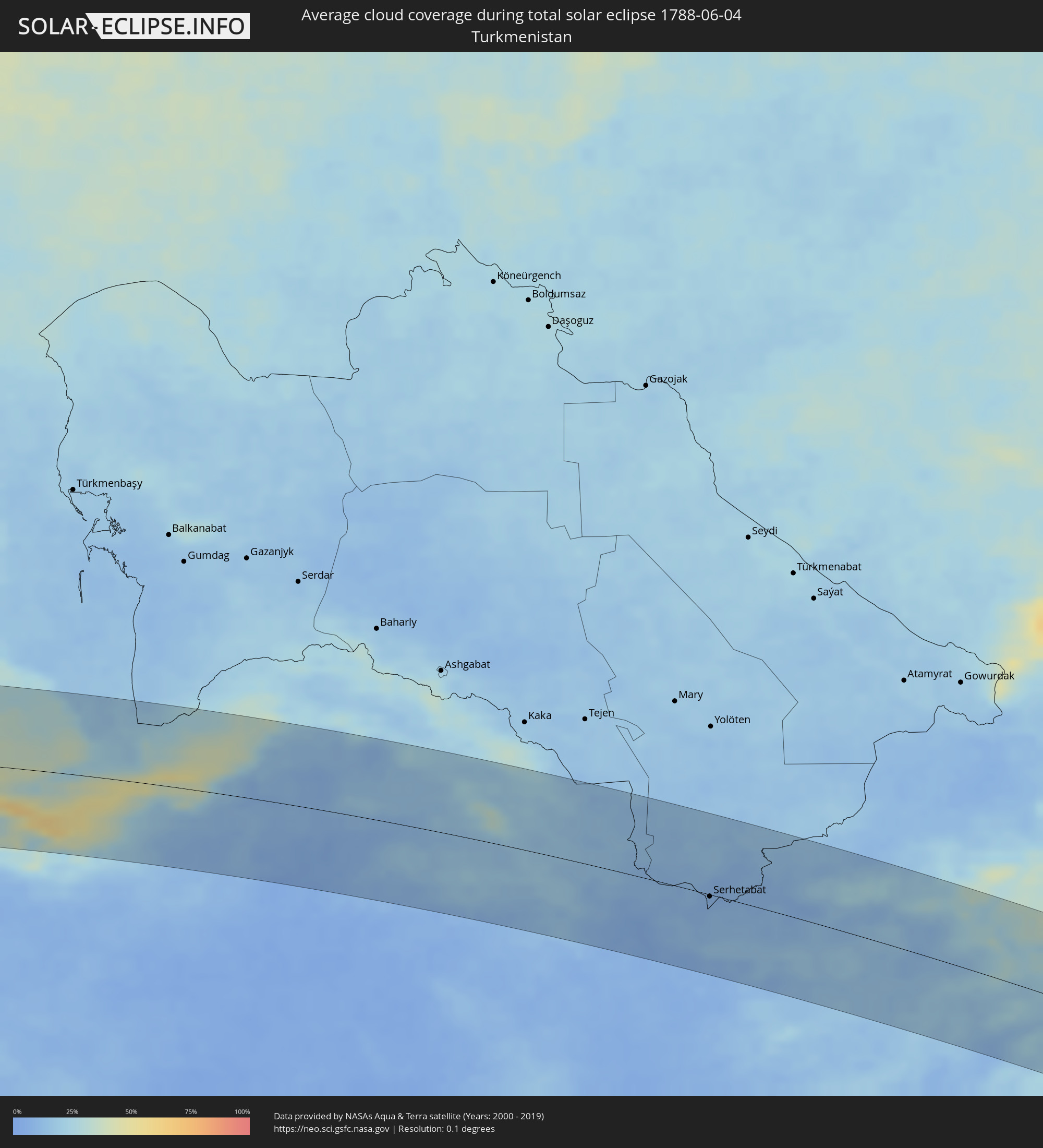 Turkmenistan
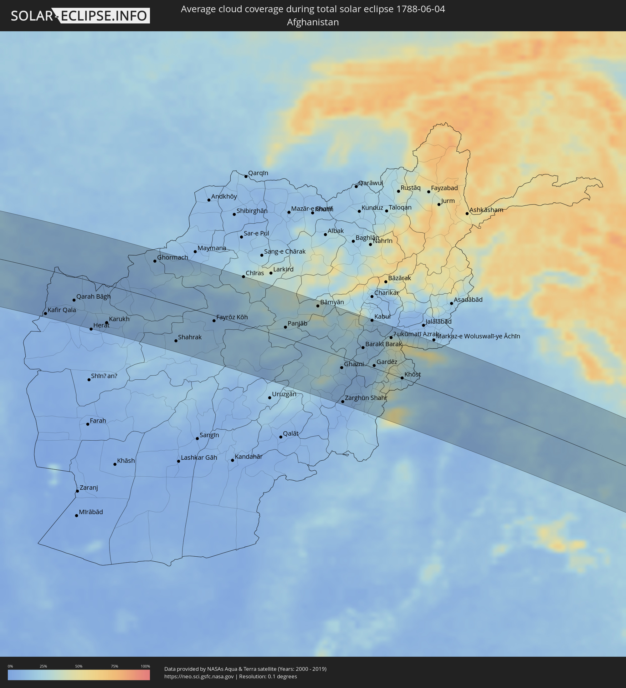 Afghanistan
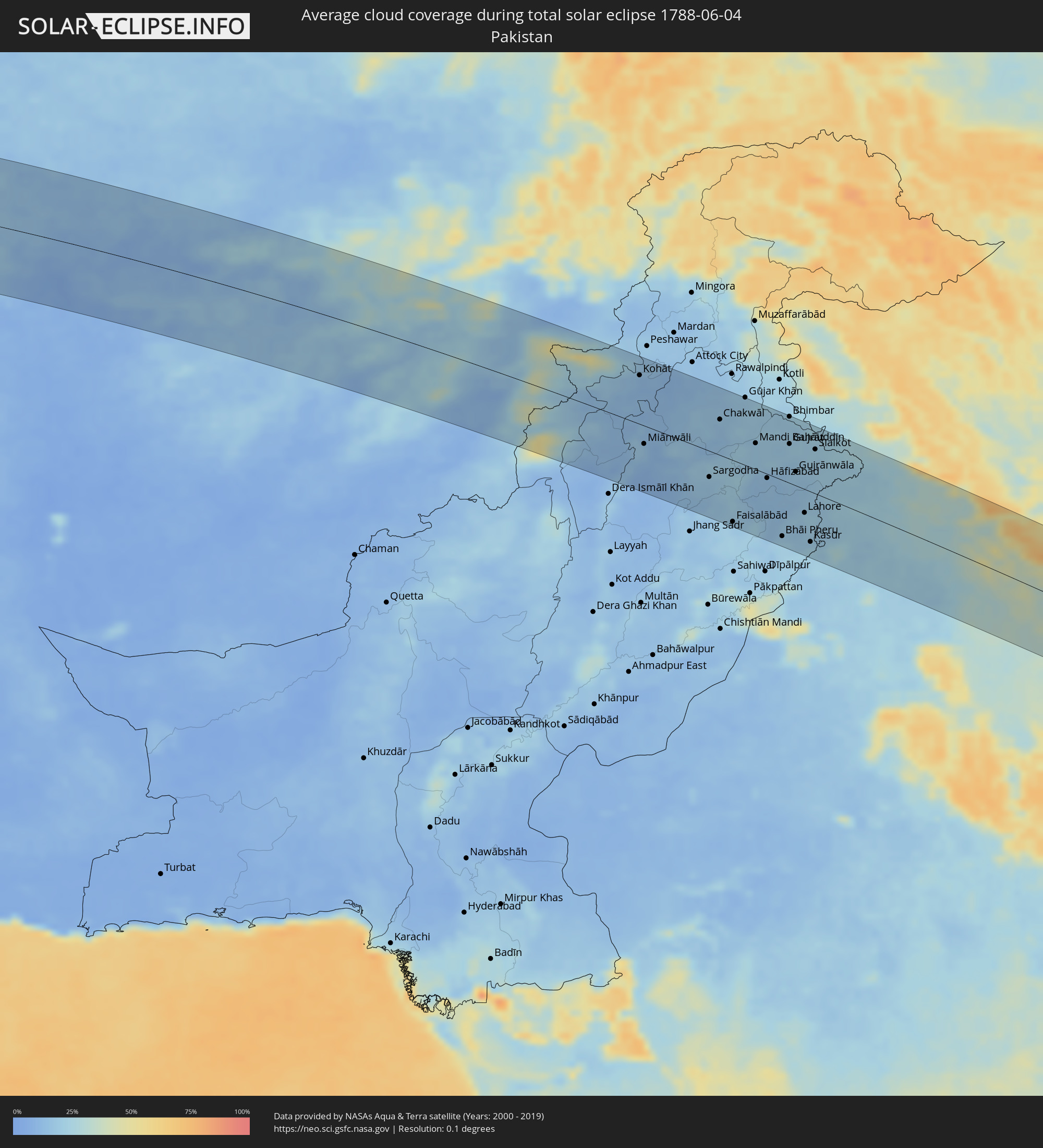 Pakistan
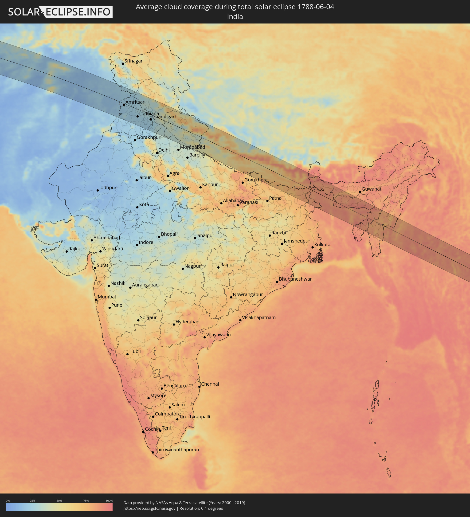 India
India
 China
China
 Nepal
Nepal
 Bangladesh
 Bhutan
 Myanmar
 Thailand
 Laos
Laos
 Vietnam
Cities inside the path of the eclipse
The following table shows all locations with a population of more than 5,000 inside the eclipse path. Cities which have more than 100,000 inhabitants are marked bold. A click at the locations opens a detailed map.
| City | Type | Eclipse duration | Local time of max. eclipse | Distance to central line | Ø Cloud coverage |
|
Kayar, Thiès
|
total | - | 07:02:33 UTC-00:16 | 85 km | 43% |
|
Saint-Louis, Saint-Louis
|
total | - | 07:03:24 UTC-00:16 | 3 km | 60% |
|
Guéoul, Louga
|
total | - | 07:02:58 UTC-00:16 | 63 km | 26% |
|
Louga, Louga
|
total | - | 07:03:05 UTC-00:16 | 55 km | 26% |
|
Rosso, Trarza
|
total | - | 07:03:48 UTC-00:16 | 16 km | 27% |
|
Rosso, Saint-Louis
|
total | - | 07:03:44 UTC-00:16 | 6 km | 30% |
|
Richard-Toll, Saint-Louis
|
total | - | 07:03:46 UTC-00:16 | 6 km | 25% |
|
Tékane, Trarza
|
total | - | 07:03:52 UTC-00:16 | 6 km | 24% |
|
Ndioum, Saint-Louis
|
total | - | 07:03:50 UTC-00:16 | 38 km | 21% |
|
Aleg, Brakna
|
total | - | 07:04:21 UTC-00:16 | 17 km | 19% |
|
Tidjikja, Tagant
|
total | - | 07:05:59 UTC-00:16 | 17 km | 15% |
|
Sirte, Surt
|
total | - | 08:51:10 UTC+00:52 | 10 km | 31% |
|
Benghazi, Banghāzī
|
total | - | 08:57:38 UTC+00:52 | 27 km | 26% |
|
Sulūq, Banghāzī
|
total | - | 08:57:24 UTC+00:52 | 80 km | 23% |
|
Tūkrah, Al Marj
|
total | - | 08:58:59 UTC+00:52 | 2 km | 27% |
|
Al Abyār, Al Marj
|
total | - | 08:58:36 UTC+00:52 | 38 km | 24% |
|
Al Marj, Al Marj
|
total | - | 08:59:21 UTC+00:52 | 15 km | 24% |
|
Al Bayḑā’, Al Jabal al Akhḑar
|
total | - | 09:01:13 UTC+00:52 | 19 km | 28% |
|
Al Qubbah, Darnah
|
total | - | 09:02:03 UTC+00:52 | 35 km | 27% |
|
Darnah, Darnah
|
total | - | 09:02:45 UTC+00:52 | 48 km | 29% |
|
Ierápetra, Crete
|
total | - | 09:52:58 UTC+01:34 | 92 km | 39% |
|
Sitia, Crete
|
total | - | 09:53:51 UTC+01:34 | 102 km | 33% |
|
Paphos, Pafos
|
total | - | 10:44:42 UTC+02:13 | 101 km | 37% |
|
Léfka, Nicosia
|
total | - | 10:45:53 UTC+02:13 | 74 km | 25% |
|
Mórfou, Nicosia
|
total | - | 10:46:15 UTC+02:13 | 67 km | 19% |
|
Kyrenia, Keryneia
|
total | - | 10:47:03 UTC+02:13 | 59 km | 22% |
|
Nicosia, Nicosia
|
total | - | 10:47:02 UTC+02:13 | 77 km | 23% |
|
Géri, Nicosia
|
total | - | 10:47:06 UTC+02:13 | 86 km | 22% |
|
Dáli, Nicosia
|
total | - | 10:47:03 UTC+02:13 | 95 km | 22% |
|
Pérgamos, Larnaka
|
total | - | 10:47:41 UTC+02:13 | 98 km | 31% |
|
Famagusta, Ammochostos
|
total | - | 10:48:15 UTC+02:13 | 94 km | 20% |
|
Paralímni, Ammochostos
|
total | - | 10:48:17 UTC+02:13 | 104 km | 26% |
|
Mercin, Mersin
|
total | - | 10:34:21 UTC+01:56 | 76 km | 37% |
|
Tarsus, Mersin
|
total | - | 10:35:01 UTC+01:56 | 85 km | 37% |
|
Adana, Adana
|
total | - | 10:36:00 UTC+01:56 | 87 km | 47% |
|
Latakia, Latakia
|
total | - | 11:04:21 UTC+02:25 | 81 km | 40% |
|
Antakya, Hatay
|
total | - | 10:37:19 UTC+01:56 | 13 km | 25% |
|
İskenderun, Hatay
|
total | - | 10:37:35 UTC+01:56 | 28 km | 43% |
|
Osmaniye, Osmaniye
|
total | - | 10:38:01 UTC+01:56 | 81 km | 39% |
|
Idlib, Idlib
|
total | - | 11:06:29 UTC+02:25 | 51 km | 16% |
|
I‘zāz, Aleppo
|
total | - | 11:07:46 UTC+02:25 | 16 km | 17% |
|
Aleppo, Aleppo
|
total | - | 11:07:48 UTC+02:25 | 28 km | 13% |
|
As Safīrah, Aleppo
|
total | - | 11:08:13 UTC+02:25 | 45 km | 15% |
|
Gaziantep, Gaziantep
|
total | - | 10:40:29 UTC+01:56 | 63 km | 20% |
|
Al Bāb, Aleppo
|
total | - | 11:08:41 UTC+02:25 | 15 km | 12% |
|
Manbij, Aleppo
|
total | - | 11:09:45 UTC+02:25 | 3 km | 12% |
|
Ath Thawrah, Ar-Raqqah
|
total | - | 11:10:45 UTC+02:25 | 87 km | 8% |
|
Şanlıurfa, Şanlıurfa
|
total | - | 10:43:39 UTC+01:56 | 57 km | 17% |
|
Ar Raqqah, Ar-Raqqah
|
total | - | 11:11:52 UTC+02:25 | 79 km | 7% |
|
Viranşehir, Şanlıurfa
|
total | - | 10:45:48 UTC+01:56 | 53 km | 16% |
|
Kızıltepe, Mardin
|
total | - | 10:47:38 UTC+01:56 | 42 km | 14% |
|
Al Ḩasakah, Al-Hasakah
|
total | - | 11:16:04 UTC+02:25 | 36 km | 11% |
|
Sinjār, Nīnawá
|
total | - | 11:51:00 UTC+02:57 | 64 km | 12% |
|
Zaxo, Dahūk
|
total | - | 11:53:03 UTC+02:57 | 23 km | 15% |
|
Dihok, Dahūk
|
total | - | 11:53:41 UTC+02:57 | 10 km | 12% |
|
Sīnah, Dahūk
|
total | - | 11:53:48 UTC+02:57 | 17 km | 10% |
|
Al Mawşil al Jadīdah, Nīnawá
|
total | - | 11:53:52 UTC+02:57 | 70 km | 9% |
|
Tallkayf, Nīnawá
|
total | - | 11:53:56 UTC+02:57 | 53 km | 9% |
|
Al-Hamdaniya, Nīnawá
|
total | - | 11:54:29 UTC+02:57 | 78 km | 10% |
|
‘Aqrah, Nīnawá
|
total | - | 11:55:43 UTC+02:57 | 29 km | 13% |
|
Erbil, Arbīl
|
total | - | 11:55:57 UTC+02:57 | 90 km | 12% |
|
Koysinceq, Arbīl
|
total | - | 11:57:24 UTC+02:57 | 104 km | 12% |
|
Orūmīyeh, Āz̄ārbāyjān-e Gharbī
|
total | - | 12:26:39 UTC+03:25 | 59 km | 19% |
|
Būkān, Āz̄ārbāyjān-e Gharbī
|
total | - | 12:29:14 UTC+03:25 | 57 km | 14% |
|
Zanjān, Zanjan
|
total | - | 12:34:27 UTC+03:25 | 37 km | 18% |
|
Rasht, Gīlān
|
total | - | 12:36:51 UTC+03:25 | 35 km | 47% |
|
Qazvin, Qazvīn
|
total | - | 12:38:03 UTC+03:25 | 75 km | 10% |
|
Sari, Māzandarān
|
total | - | 12:44:50 UTC+03:25 | 18 km | 47% |
|
Gorgān, Golestān
|
total | - | 12:47:43 UTC+03:25 | 28 km | 52% |
|
Sabzevar, Razavi Khorasan
|
total | - | 12:54:59 UTC+03:25 | 6 km | 10% |
|
Nīshābūr, Razavi Khorasan
|
total | - | 12:57:17 UTC+03:25 | 26 km | 17% |
|
Mashhad, Razavi Khorasan
|
total | - | 12:58:46 UTC+03:25 | 51 km | 20% |
|
Kafir Qala, Herat
|
total | - | 13:37:24 UTC+04:00 | 97 km | 8% |
|
Serhetabat, Mary
|
total | - | 13:32:55 UTC+03:53 | 2 km | 8% |
|
Karukh, Herat
|
total | - | 13:40:35 UTC+04:00 | 83 km | 8% |
|
Ghormach, Badghis
|
total | - | 13:41:40 UTC+04:00 | 80 km | 13% |
|
Bāmyān, Bamyan
|
total | - | 13:49:44 UTC+04:00 | 92 km | 34% |
|
Ghazni, Ghazni
|
total | - | 13:52:07 UTC+04:00 | 24 km | 17% |
|
Barakī Barak, Logar
|
total | - | 13:52:33 UTC+04:00 | 35 km | 17% |
|
Paghmān, Kabul
|
total | - | 13:51:51 UTC+04:00 | 101 km | 26% |
|
Kabul, Kabul
|
total | - | 13:52:17 UTC+04:00 | 101 km | 15% |
|
Gardēz, Paktia
|
total | - | 13:53:25 UTC+04:00 | 5 km | 15% |
|
Khōst, Khowst
|
total | - | 13:54:50 UTC+04:00 | 0 km | 24% |
|
Sargodha, Punjab
|
total | - | 14:28:44 UTC+04:28 | 40 km | 18% |
|
Chiniot, Punjab
|
total | - | 14:29:37 UTC+04:28 | 67 km | 19% |
|
Faisalābād, Punjab
|
total | - | 14:30:07 UTC+04:28 | 95 km | 19% |
|
Sheikhupura, Punjab
|
total | - | 14:31:04 UTC+04:28 | 32 km | 13% |
|
Bhimbar, Azad Kashmir
|
total | - | 14:29:41 UTC+04:28 | 101 km | 20% |
|
Gujrāt, Punjab
|
total | - | 14:30:10 UTC+04:28 | 60 km | 20% |
|
Gujrānwāla, Punjab
|
total | - | 14:30:49 UTC+04:28 | 21 km | 19% |
|
Lahore, Punjab
|
total | - | 14:31:46 UTC+04:28 | 36 km | 18% |
|
Kasūr, Punjab
|
total | - | 14:32:26 UTC+04:28 | 77 km | 21% |
|
Sialkot, Punjab
|
total | - | 14:30:54 UTC+04:28 | 68 km | 21% |
|
Amritsar, Punjab
|
total | - | 15:25:23 UTC+05:21 | 10 km | 22% |
|
Jalandhar, Punjab
|
total | - | 15:26:42 UTC+05:21 | 14 km | 22% |
|
Ludhiāna, Punjab
|
total | - | 15:27:34 UTC+05:21 | 47 km | 20% |
|
Patiāla, Punjab
|
total | - | 15:28:58 UTC+05:21 | 85 km | 21% |
|
Chandigarh, Chandigarh
|
total | - | 15:28:59 UTC+05:21 | 29 km | 25% |
|
Yamunānagar, Haryana
|
total | - | 15:30:21 UTC+05:21 | 73 km | 32% |
|
Sahāranpur, Uttar Pradesh
|
total | - | 15:30:52 UTC+05:21 | 79 km | 31% |
|
Dehra Dūn, Uttarakhand
|
total | - | 15:31:02 UTC+05:21 | 24 km | 36% |
|
Mahendranagar, Far Western
|
total | - | 15:55:31 UTC+05:41 | 75 km | 45% |
|
Dhangarhi, Far Western
|
total | - | 15:56:03 UTC+05:41 | 86 km | 47% |
|
Burang, Tibet Autonomous Region
|
total | - | 18:13:28 UTC+08:00 | 98 km | 29% |
|
Butwāl, Western Region
|
total | - | 16:00:10 UTC+05:41 | 69 km | 71% |
|
Pokhara, Western Region
|
total | - | 15:59:58 UTC+05:41 | 10 km | 63% |
|
Bharatpur, Central Region
|
total | - | 16:01:05 UTC+05:41 | 29 km | 61% |
|
Bīrganj, Central Region
|
total | - | 16:02:17 UTC+05:41 | 78 km | 78% |
|
Kathmandu, Central Region
|
total | - | 16:01:51 UTC+05:41 | 11 km | 67% |
|
Janakpur, Central Region
|
total | - | 16:03:30 UTC+05:41 | 63 km | 78% |
|
Biratnagar, Eastern Region
|
total | - | 16:04:54 UTC+05:41 | 30 km | 82% |
|
Dharān Bāzār, Eastern Region
|
total | - | 16:04:29 UTC+05:41 | 7 km | 72% |
|
Shiliguri, West Bengal
|
total | - | 15:45:21 UTC+05:21 | 47 km | 87% |
|
Dinājpur, Rangpur Division
|
total | - | 16:18:54 UTC+05:53 | 52 km | 88% |
|
Saidpur, Rājshāhi
|
total | - | 16:18:55 UTC+05:53 | 26 km | 89% |
|
Samtse, Samchi
|
total | - | 16:23:02 UTC+05:58 | 95 km | 90% |
|
Rangpur, Rangpur Division
|
total | - | 16:19:12 UTC+05:53 | 13 km | 88% |
|
Sarishābāri, Dhaka
|
total | - | 16:20:42 UTC+05:53 | 87 km | 85% |
|
Jamālpur, Dhaka
|
total | - | 16:20:35 UTC+05:53 | 65 km | 90% |
|
Mymensingh, Dhaka
|
total | - | 16:21:03 UTC+05:53 | 60 km | 89% |
|
Netrakona, Dhaka
|
total | - | 16:21:06 UTC+05:53 | 33 km | 92% |
|
Kishorganj, Dhaka
|
total | - | 16:21:38 UTC+05:53 | 75 km | 92% |
|
Habiganj, Sylhet
|
total | - | 16:22:04 UTC+05:53 | 53 km | 93% |
|
Sylhet, Sylhet
|
total | - | 16:21:45 UTC+05:53 | 20 km | 89% |
|
Aizawl, Mizoram
|
total | - | 15:51:19 UTC+05:21 | 59 km | 81% |
|
Mawlaik, Sagain
|
total | - | 16:55:50 UTC+06:24 | 9 km | 79% |
|
Shwebo, Sagain
|
total | - | 16:57:29 UTC+06:24 | 39 km | 88% |
|
Mandalay, Mandalay
|
total | - | 16:58:14 UTC+06:24 | 81 km | 91% |
|
Pyin Oo Lwin, Mandalay
|
total | - | 16:58:18 UTC+06:24 | 58 km | 90% |
|
Mogok, Mandalay
|
total | - | 16:57:26 UTC+06:24 | 33 km | 90% |
|
Lashio, Shan
|
total | - | 16:57:51 UTC+06:24 | 91 km | 88% |
|
Mae Sai, Chiang Rai
|
total | - | 17:18:08 UTC+06:42 | 62 km | 94% |
|
Tachilek, Shan
|
total | - | 17:18:07 UTC+06:42 | 60 km | 94% |
|
Chiang Saen, Chiang Rai
|
total | - | 17:18:19 UTC+06:42 | 68 km | 90% |
|
Chiang Khong, Chiang Rai
|
total | - | 17:18:24 UTC+06:42 | 55 km | 90% |
|
Ban Houayxay, Bokeo Province
|
total | - | 17:18:23 UTC+06:42 | 53 km | 90% |
|
Ban Houakhoua, Bokeo Province
|
total | - | 17:18:26 UTC+06:42 | 54 km | 89% |
|
Louang Namtha, Loungnamtha
|
total | - | 17:17:58 UTC+06:42 | 60 km | 90% |
|
Muang Xay, Oudômxai
|
total | - | 17:18:18 UTC+06:42 | 60 km | 94% |
|
Luang Prabang, Louangphabang
|
total | - | 17:19:03 UTC+06:42 | 13 km | 88% |
|
Muang Phônsavan, Xiangkhoang
|
total | - | 17:19:34 UTC+06:42 | 8 km | 89% |
|
Yên Vinh, Nghệ An
|
total | - | 17:45:00 UTC+07:06 | 25 km | 87% |
|
Vinh, Nghệ An
|
total | - | 17:45:00 UTC+07:06 | 26 km | 87% |
|
Hà Tĩnh, Hà Tĩnh
|
total | - | 17:45:16 UTC+07:06 | 3 km | 85% |
|
Kwang Binh, Quảng Bình
|
total | - | 17:45:59 UTC+07:06 | 53 km | 82% |