Total solar eclipse of 06/20/1955
| Day of week: | Monday |
| Maximum duration of eclipse: | 07m08s |
| Maximum width of eclipse path: | 254 km |
| Saros cycle: | 136 |
| Coverage: | 100% |
| Magnitude: | 1.0776 |
| Gamma: | -0.1528 |
Wo kann man die Sonnenfinsternis vom 06/20/1955 sehen?
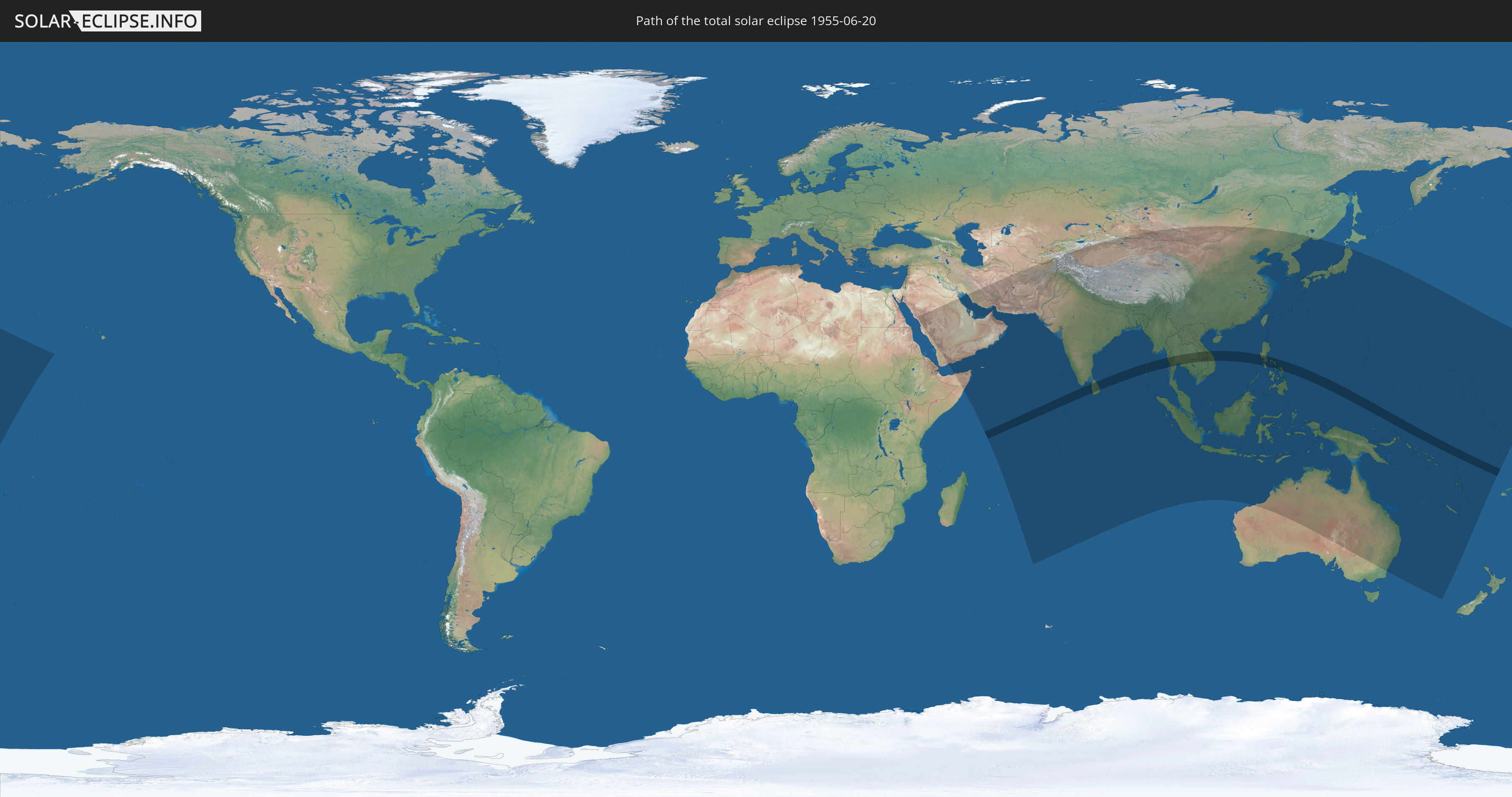
Die Sonnenfinsternis am 06/20/1955 kann man in 60 Ländern als partielle Sonnenfinsternis beobachten.
Der Finsternispfad verläuft durch 12 Länder. Nur in diesen Ländern ist sie als total Sonnenfinsternis zu sehen.
In den folgenden Ländern ist die Sonnenfinsternis total zu sehen
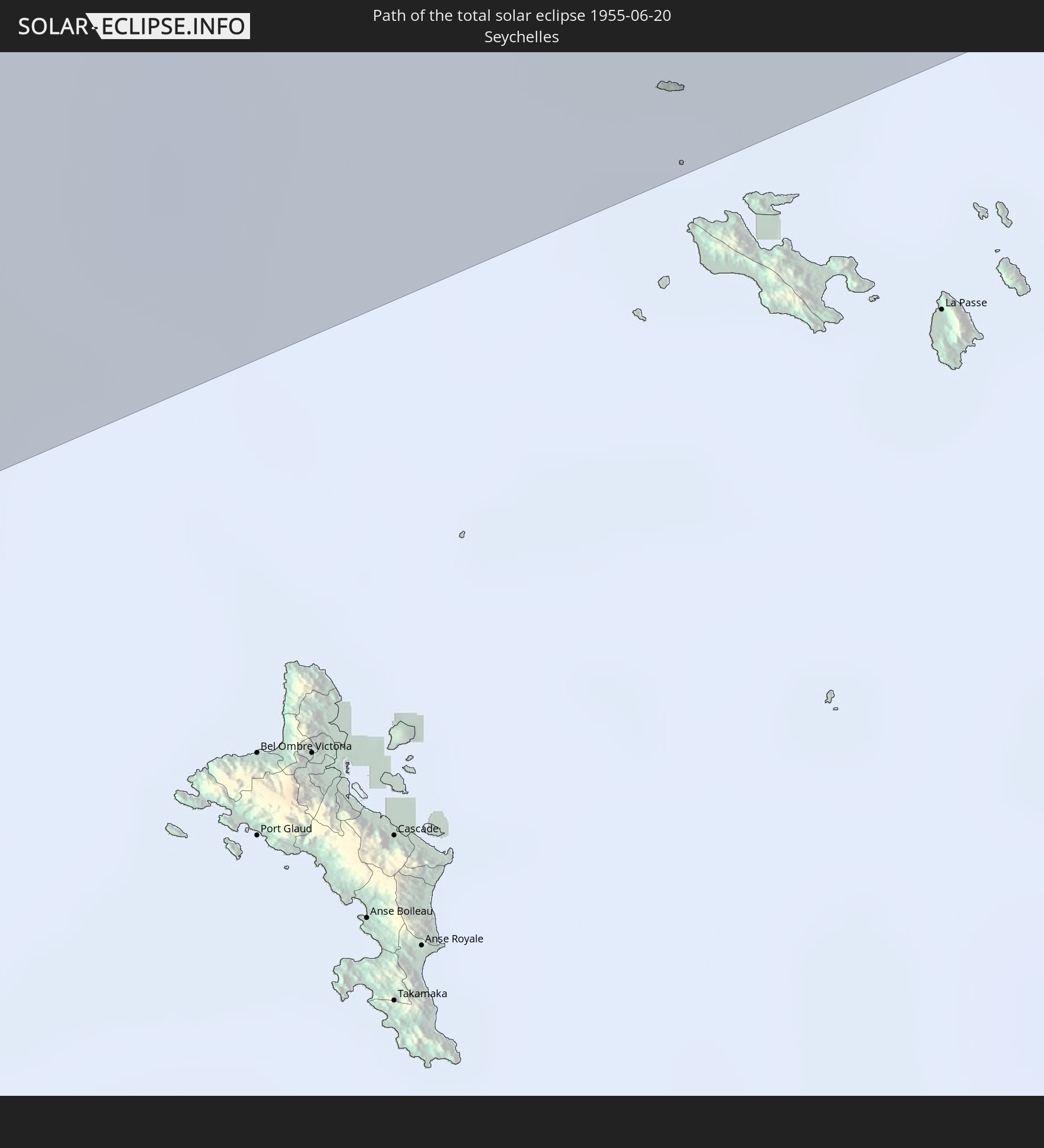 Seychelles
 India
India
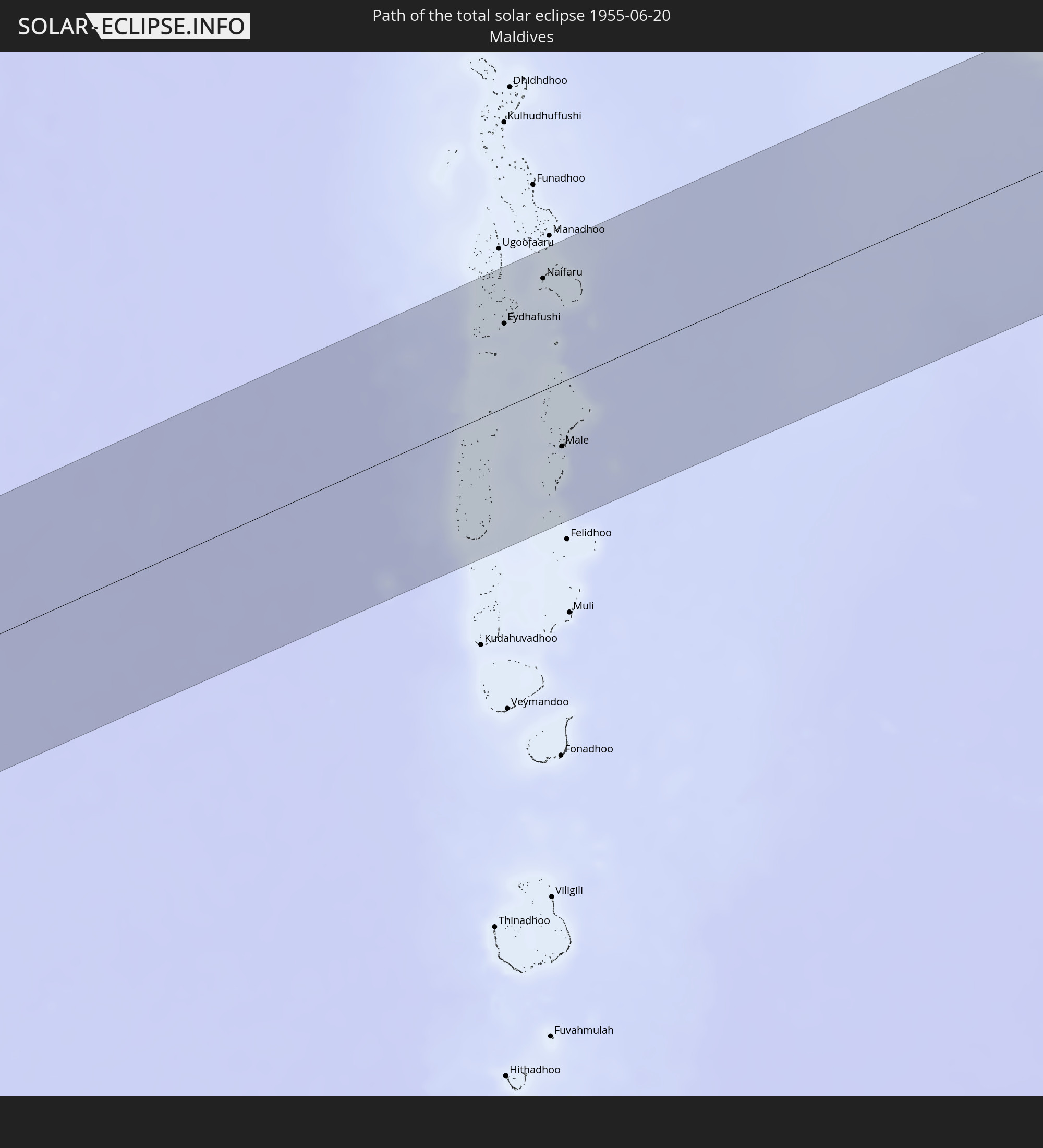 Maldives
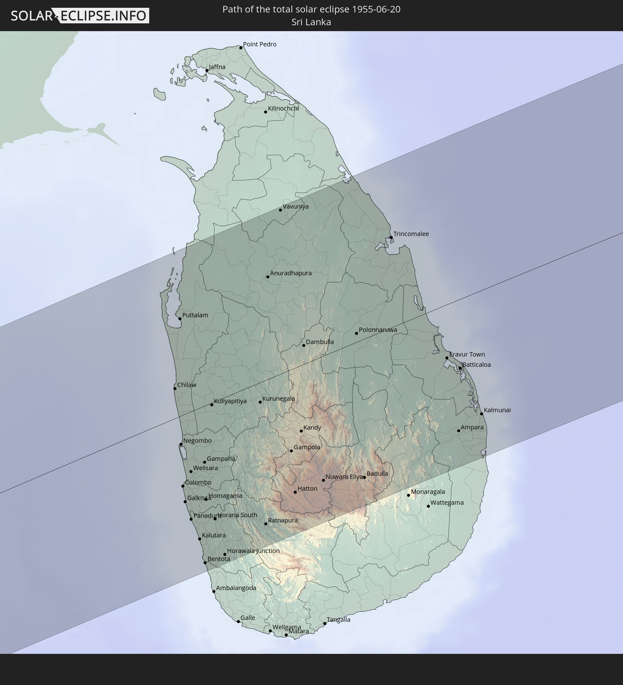 Sri Lanka
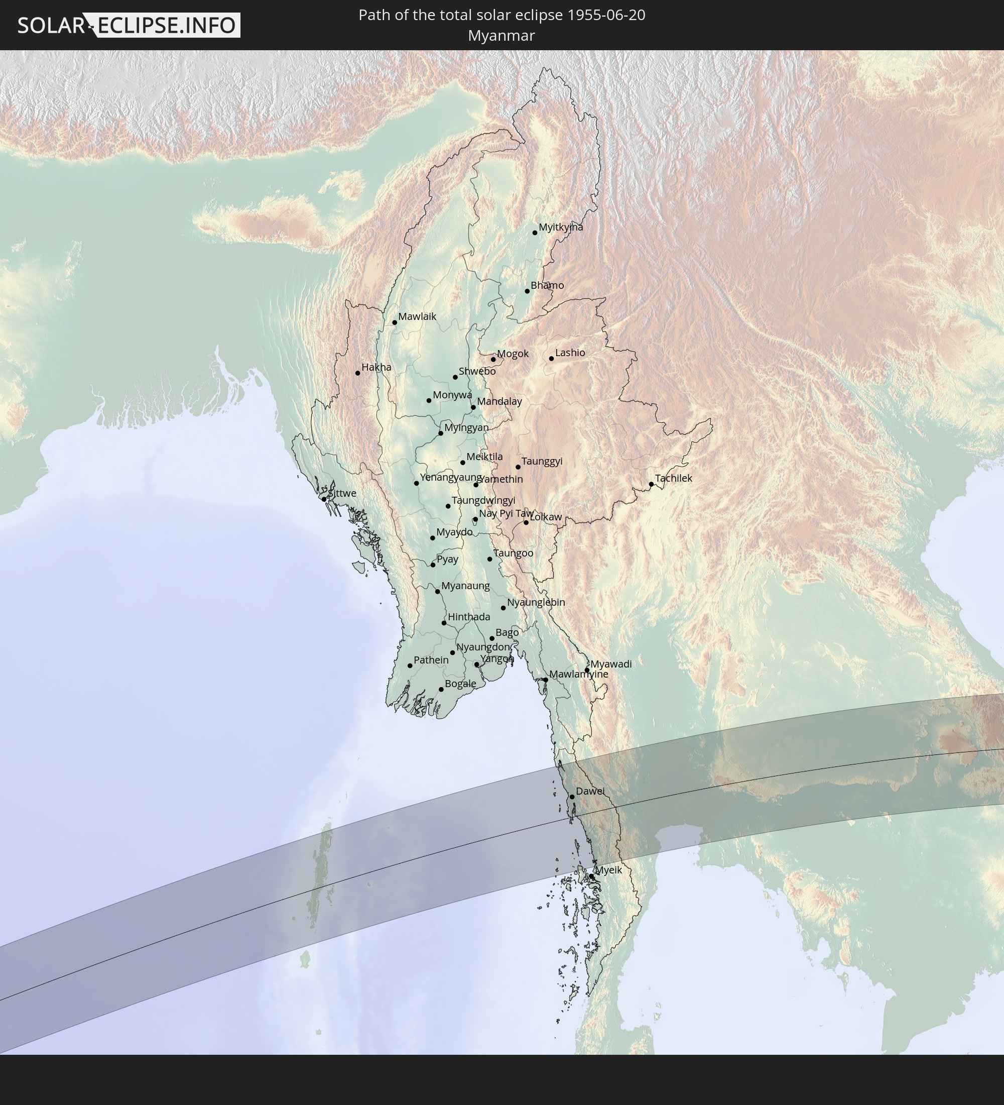 Myanmar
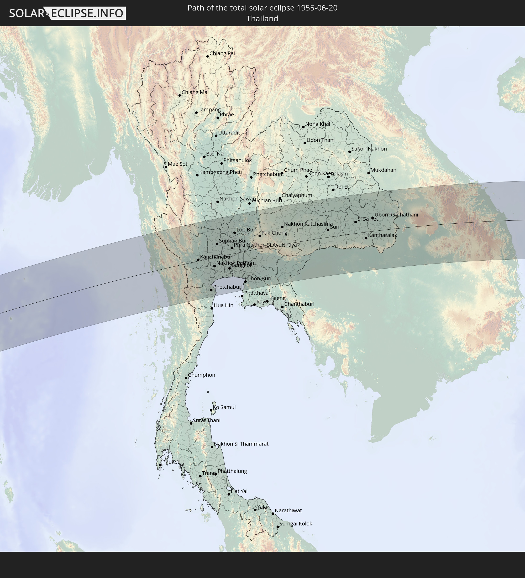 Thailand
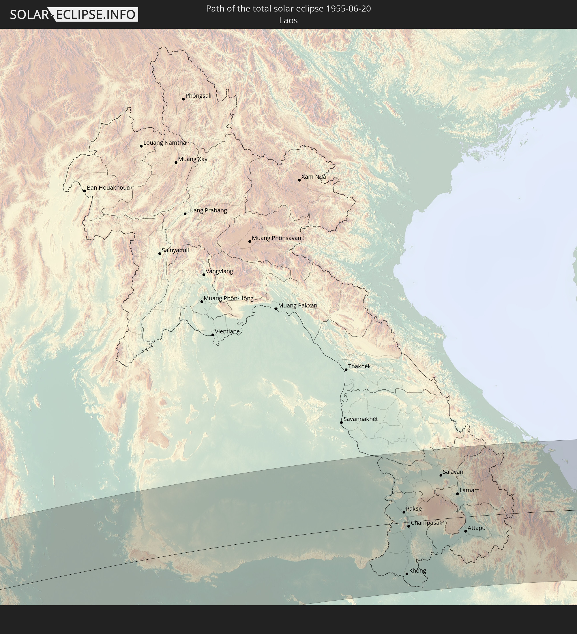 Laos
Laos
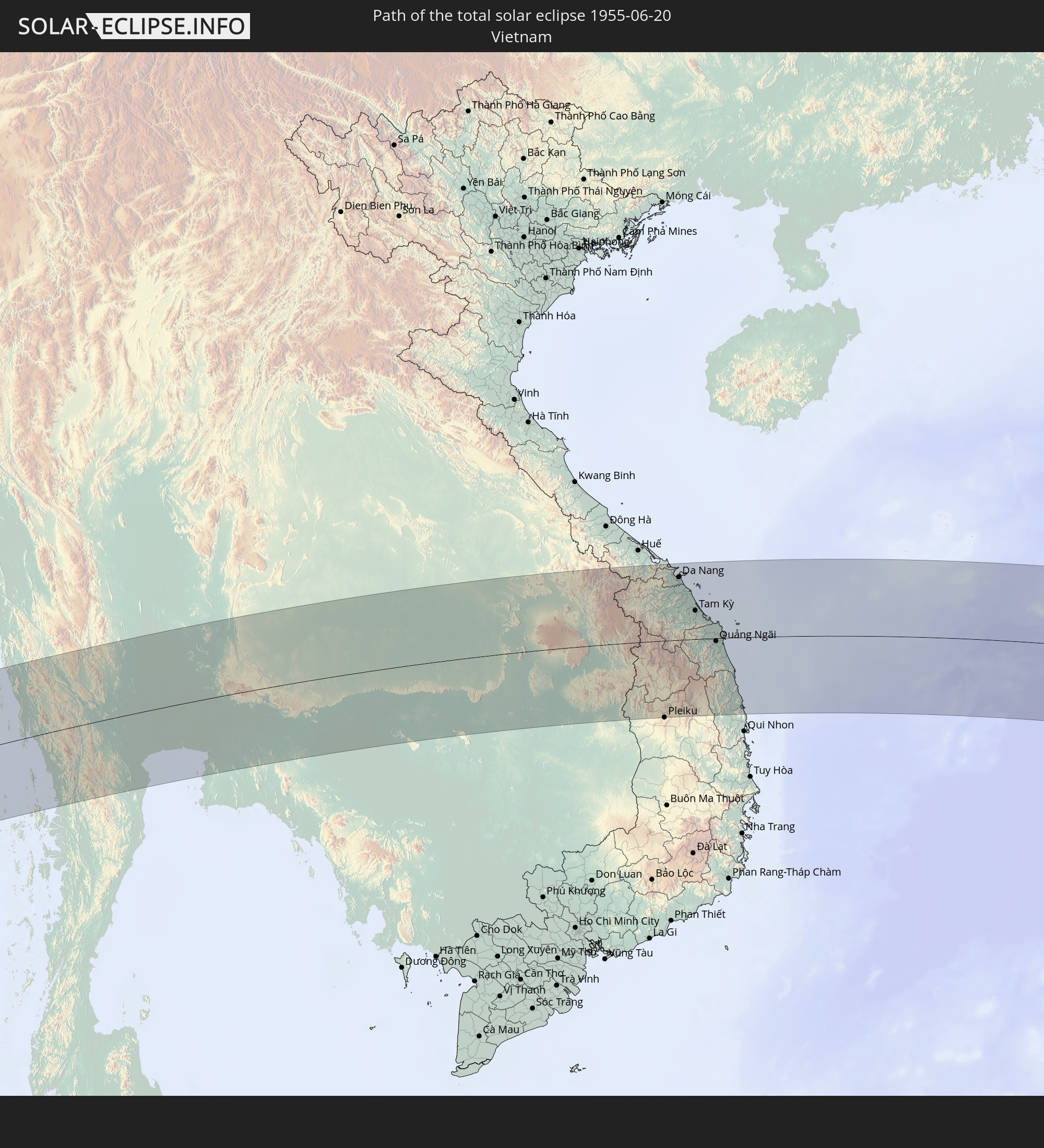 Vietnam
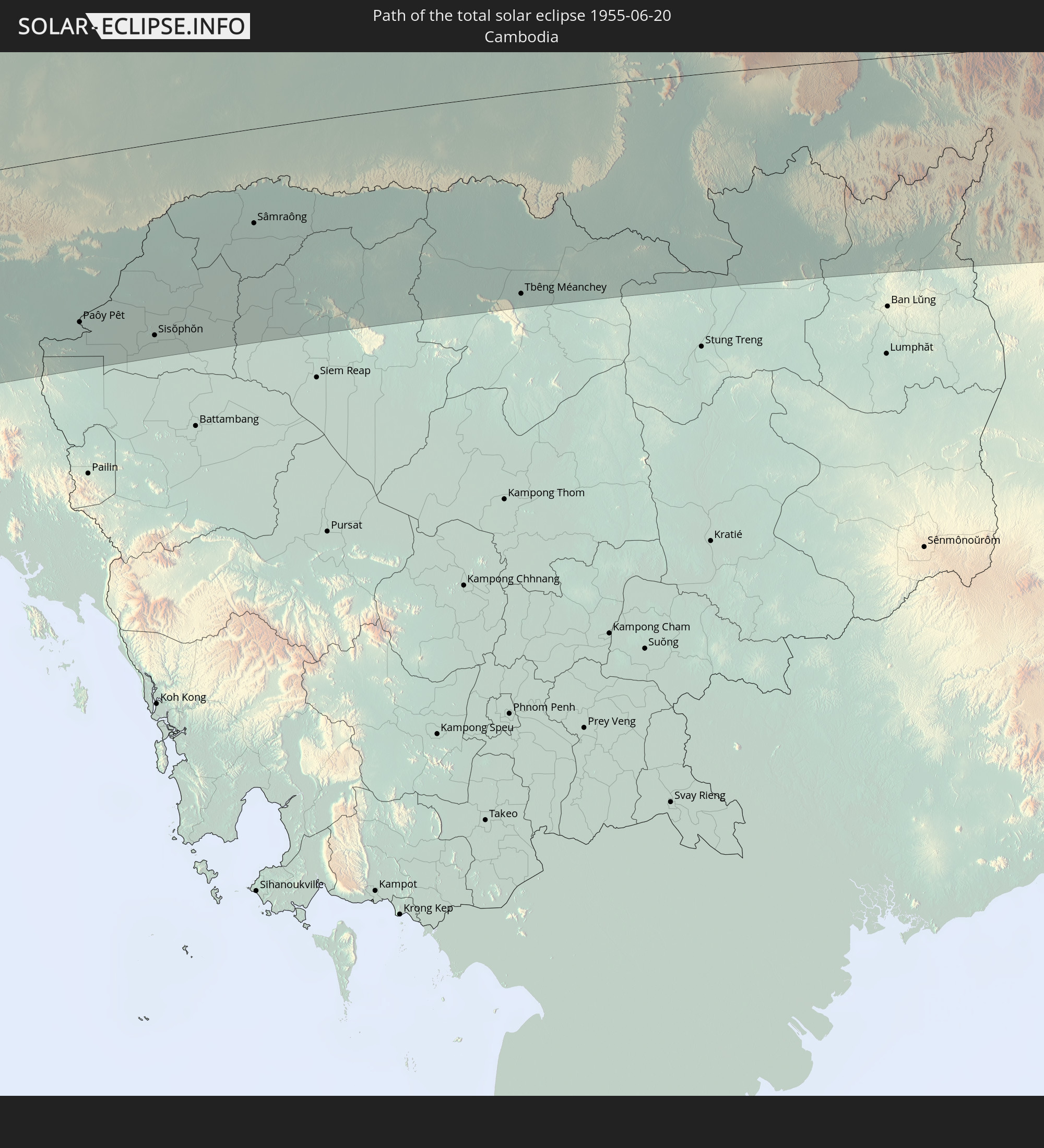 Cambodia
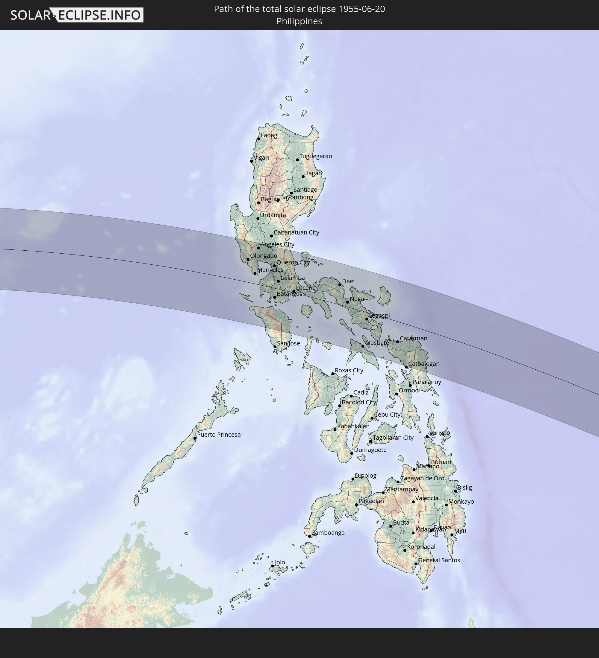 Philippines
 Palau
Palau
 Solomon Islands
In den folgenden Ländern ist die Sonnenfinsternis partiell zu sehen
 Russia
 United States Minor Outlying Islands
 Kiribati
 Saudi Arabia
 Somalia
 Yemen
Yemen
 Iran
Iran
 Seychelles
 Kuwait
 Bahrain
 Qatar
Qatar
 United Arab Emirates
 Oman
Oman
 Uzbekistan
 Mauritius
 Afghanistan
 Pakistan
 Tajikistan
 India
India
 Kyrgyzstan
 British Indian Ocean Territory
 Maldives
 China
China
 Sri Lanka
 Nepal
Nepal
 Mongolia
 Bangladesh
 Bhutan
 Myanmar
 Indonesia
 Cocos Islands
 Thailand
 Malaysia
 Laos
Laos
 Vietnam
 Cambodia
 Singapore
 Christmas Island
 Australia
 Macau
Macau
 Hong Kong
 Brunei
 Taiwan
 Philippines
 Japan
Japan
 East Timor
 North Korea
 South Korea
 Palau
Palau
 Federated States of Micronesia
 Papua New Guinea
 Guam
Guam
 Northern Mariana Islands
 Solomon Islands
 New Caledonia
 Marshall Islands
 Vanuatu
 Nauru
Nauru
 Norfolk Island
 Tuvalu
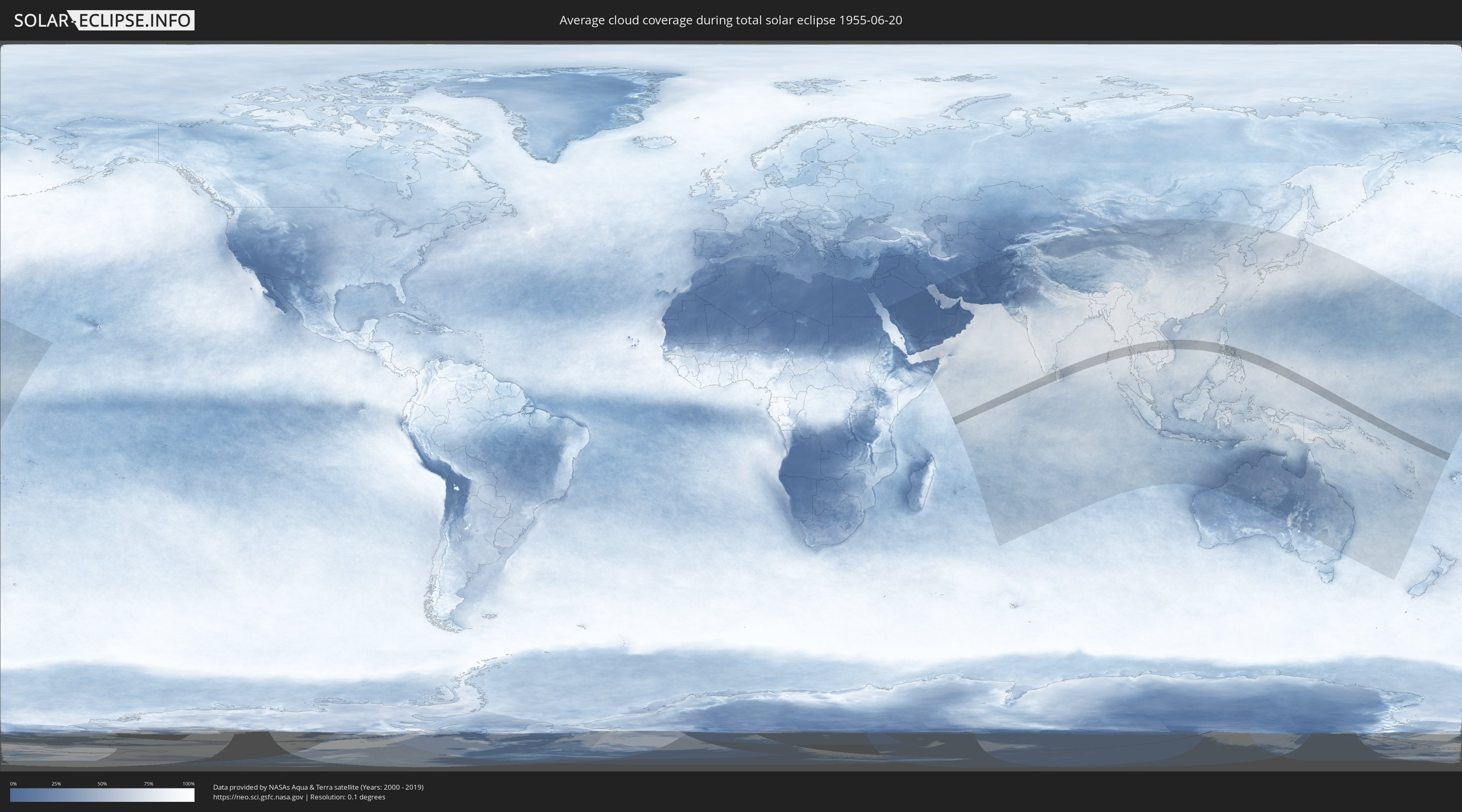
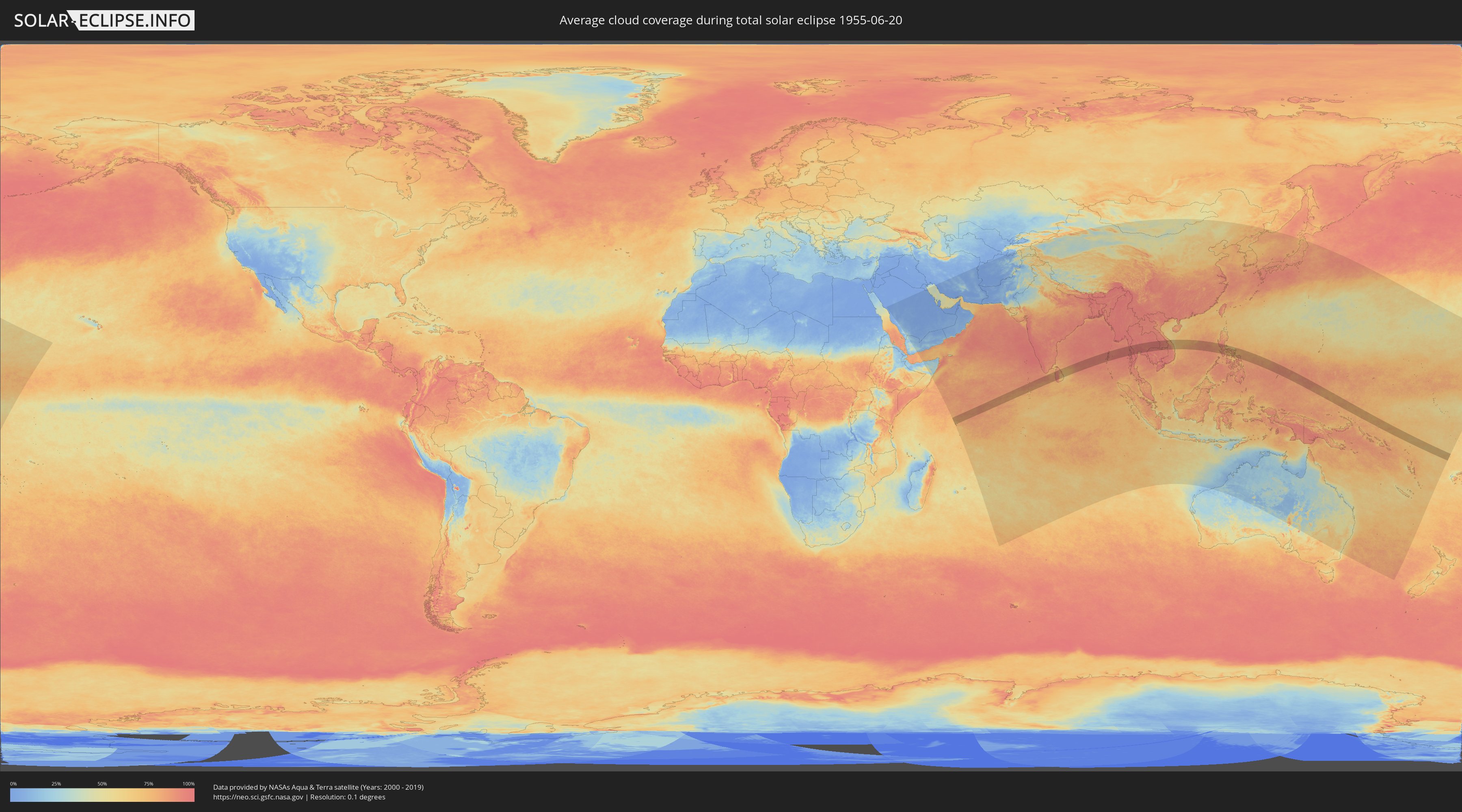
How will be the weather during the total solar eclipse on 06/20/1955?
Where is the best place to see the total solar eclipse of 06/20/1955?
The following maps show the average cloud coverage for the day of the total solar eclipse.
With the help of these maps, it is possible to find the place along the eclipse path, which has the best
chance of a cloudless sky.
Nevertheless, you should consider local circumstances and inform about the weather of your chosen
observation site.
The data is provided by NASAs satellites
AQUA and TERRA.
The cloud maps are averaged over a period of 19 years (2000 - 2019).
Detailed country maps
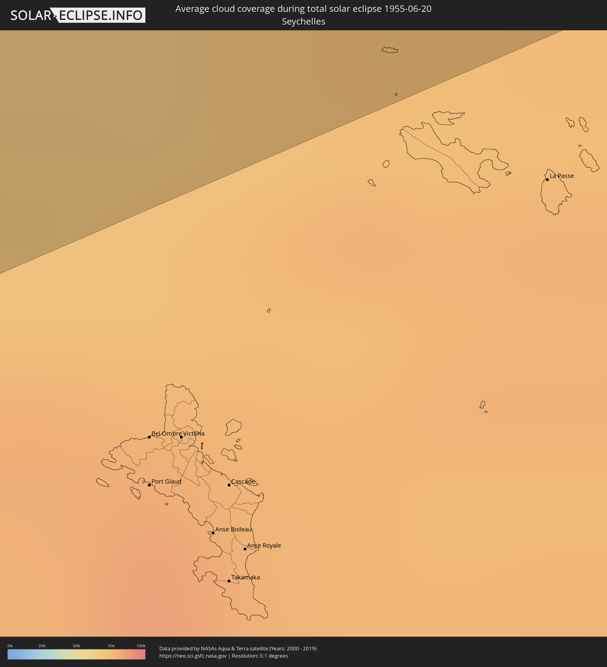 Seychelles
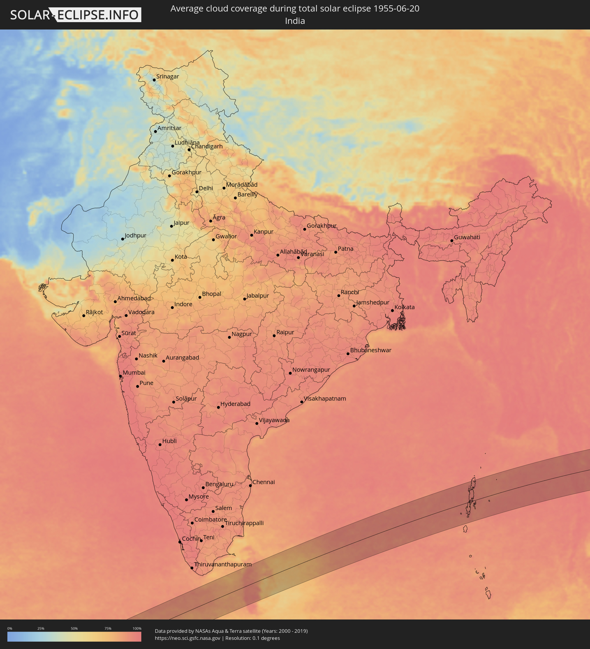 India
India
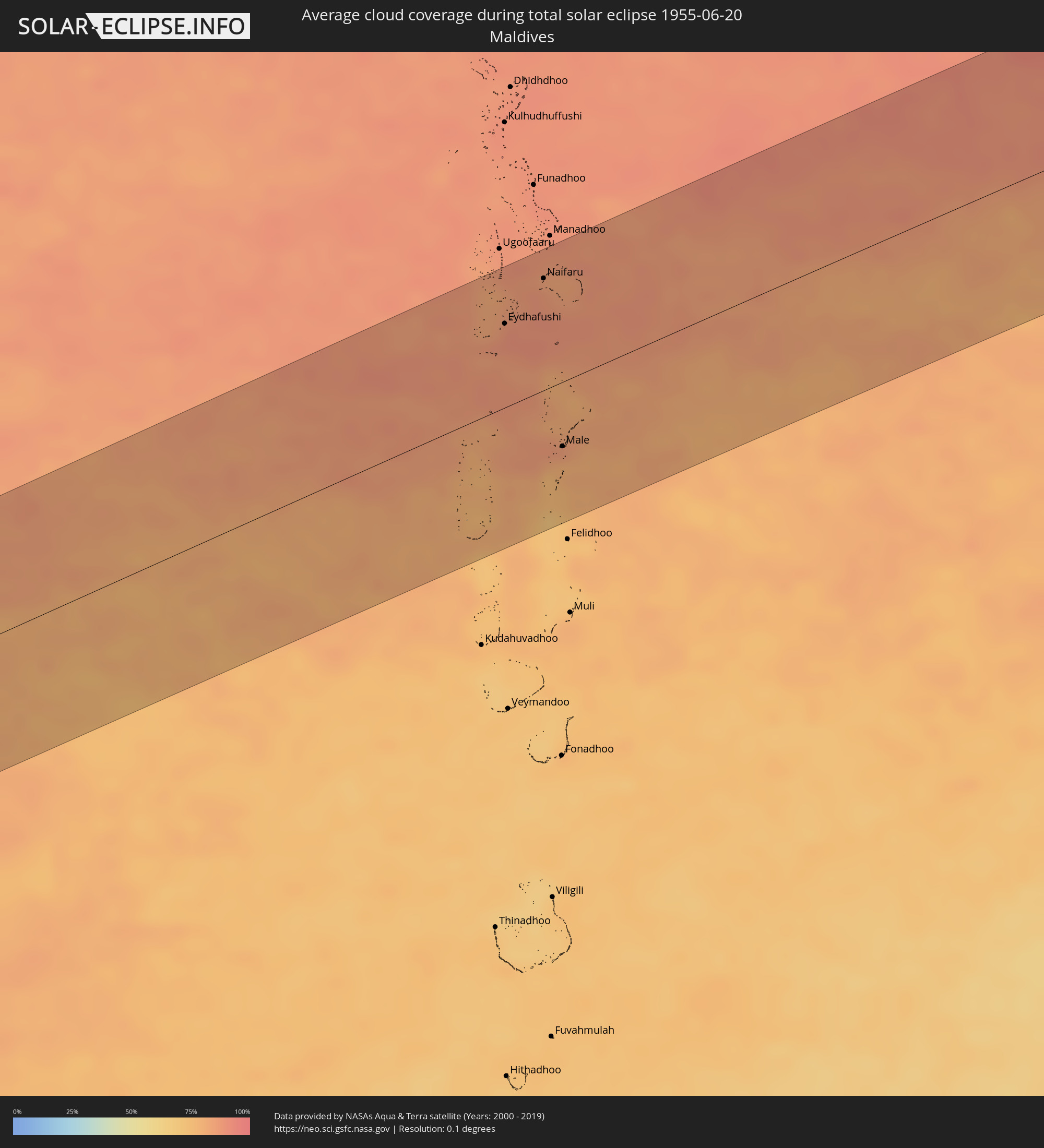 Maldives
 Sri Lanka
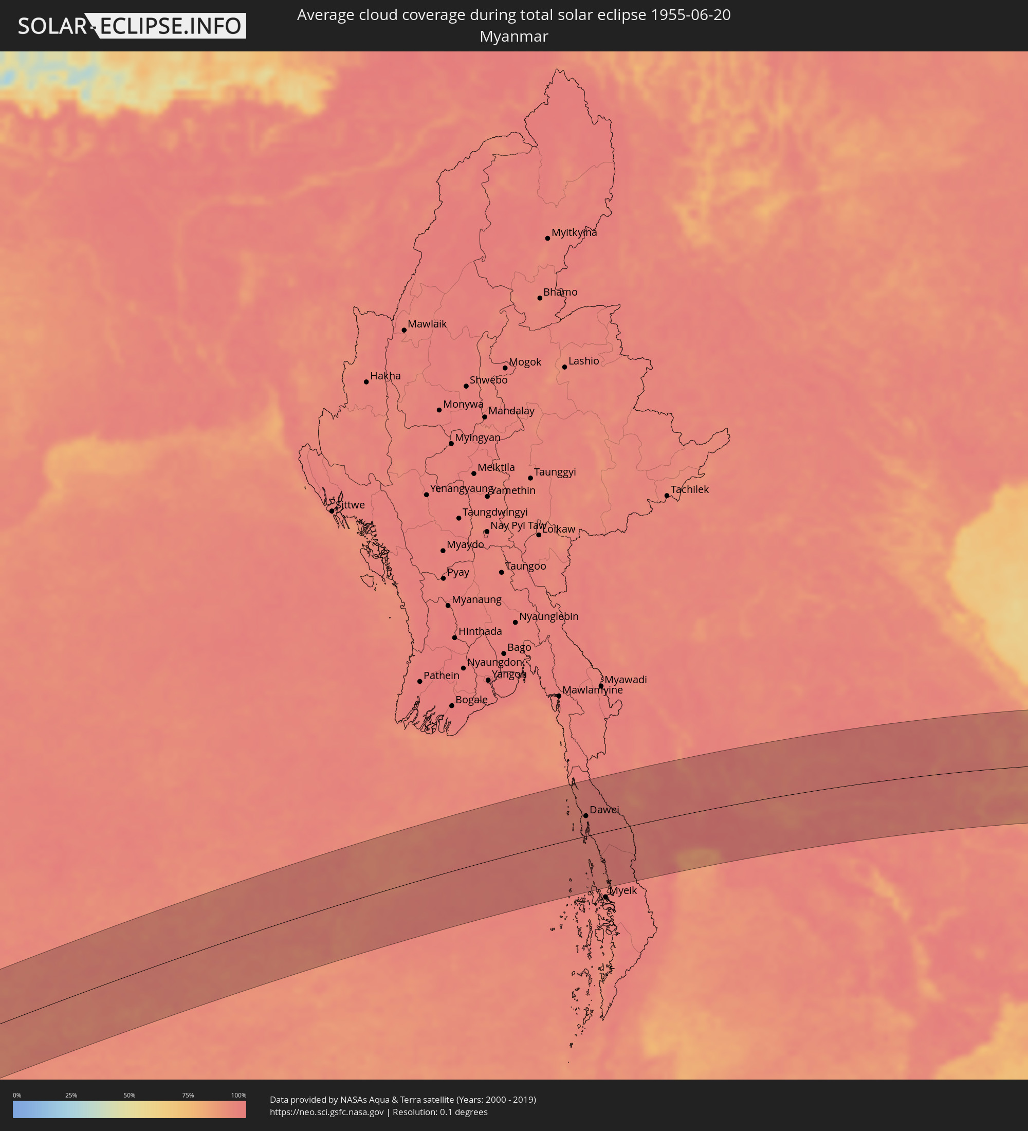 Myanmar
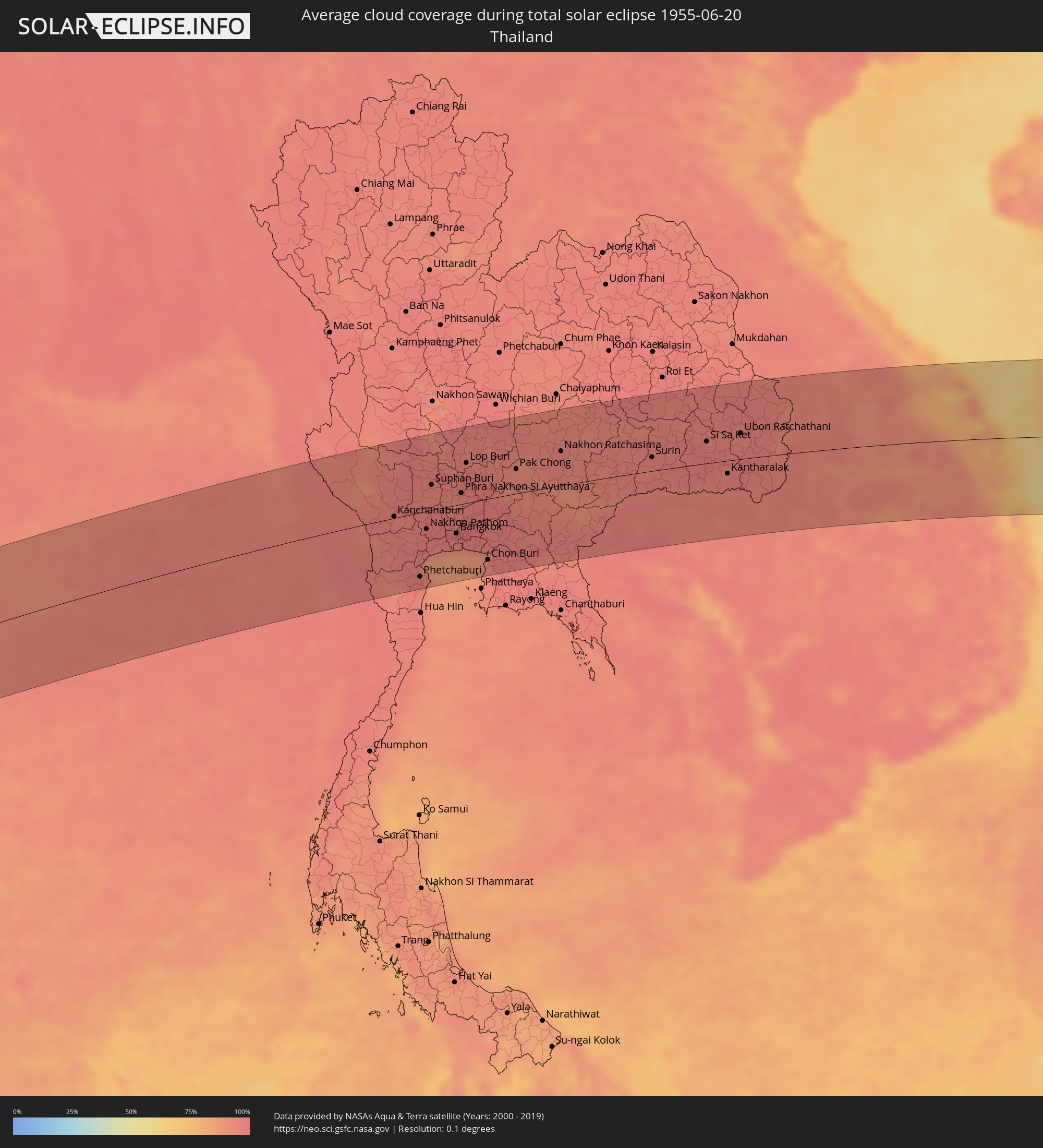 Thailand
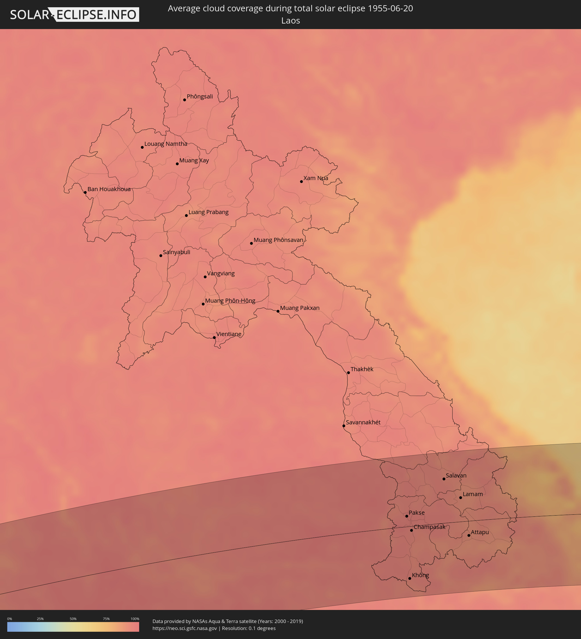 Laos
Laos
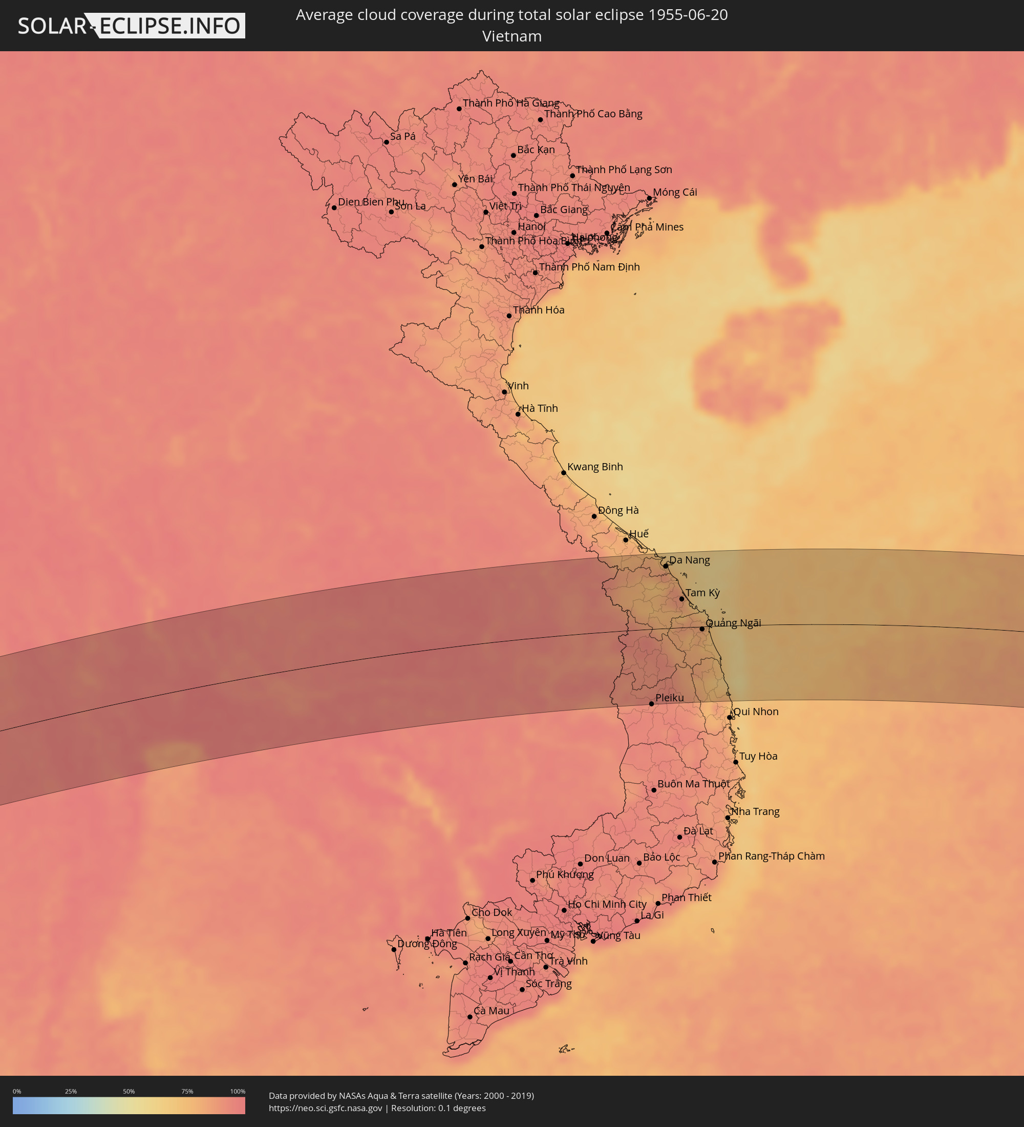 Vietnam
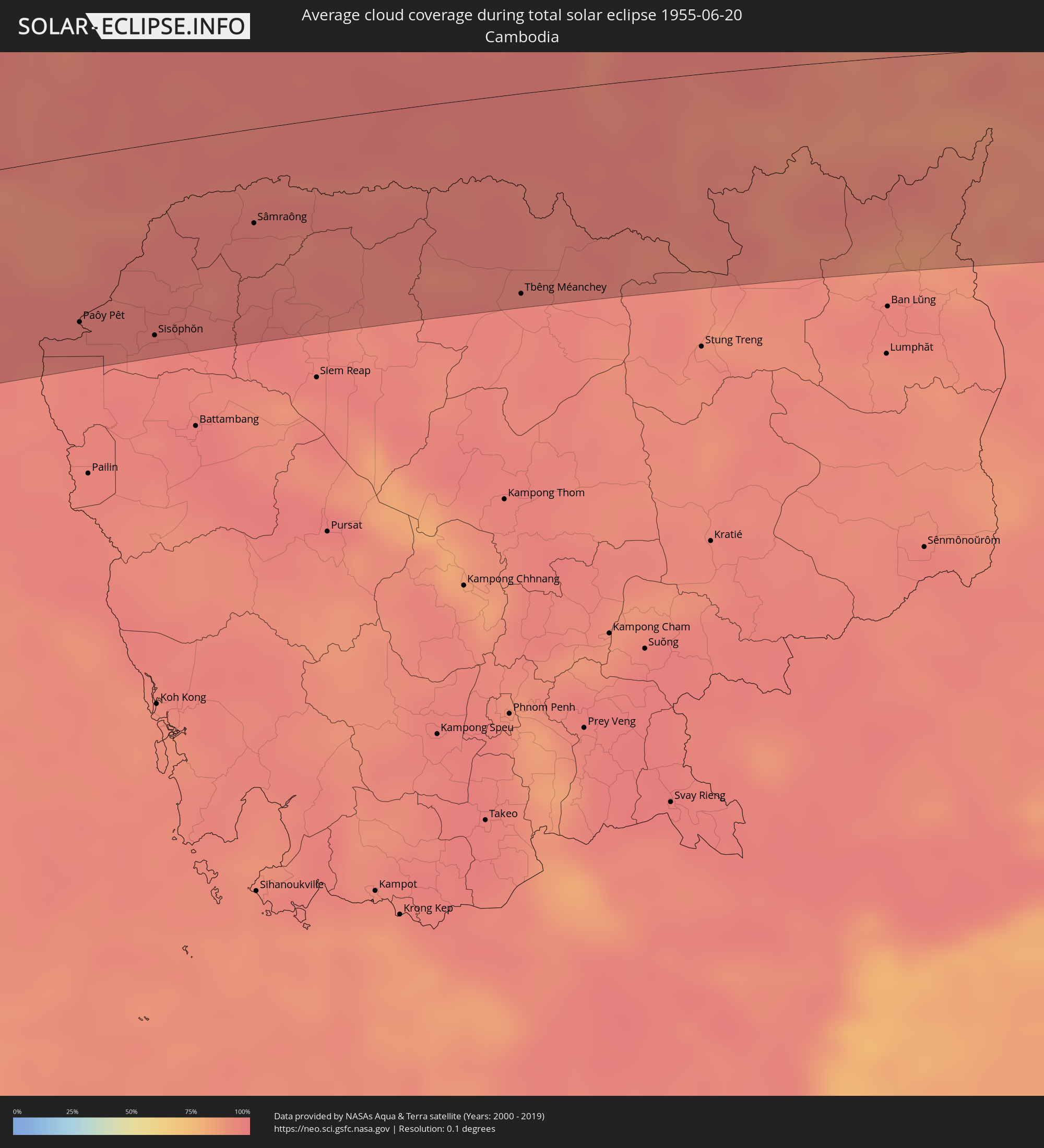 Cambodia
 Philippines
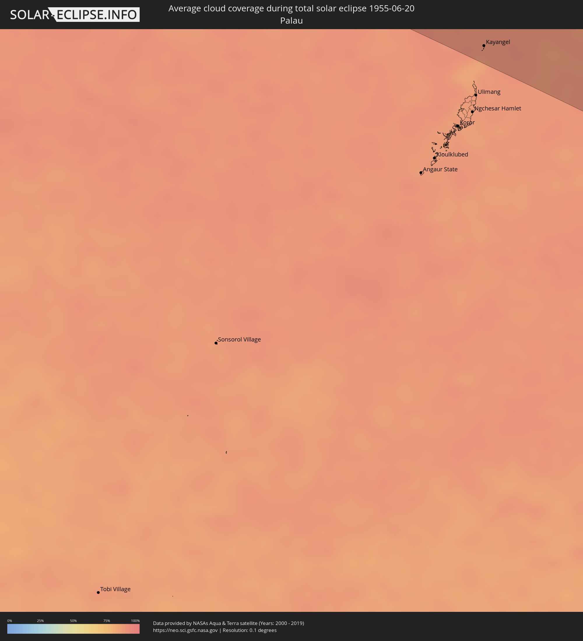 Palau
Palau
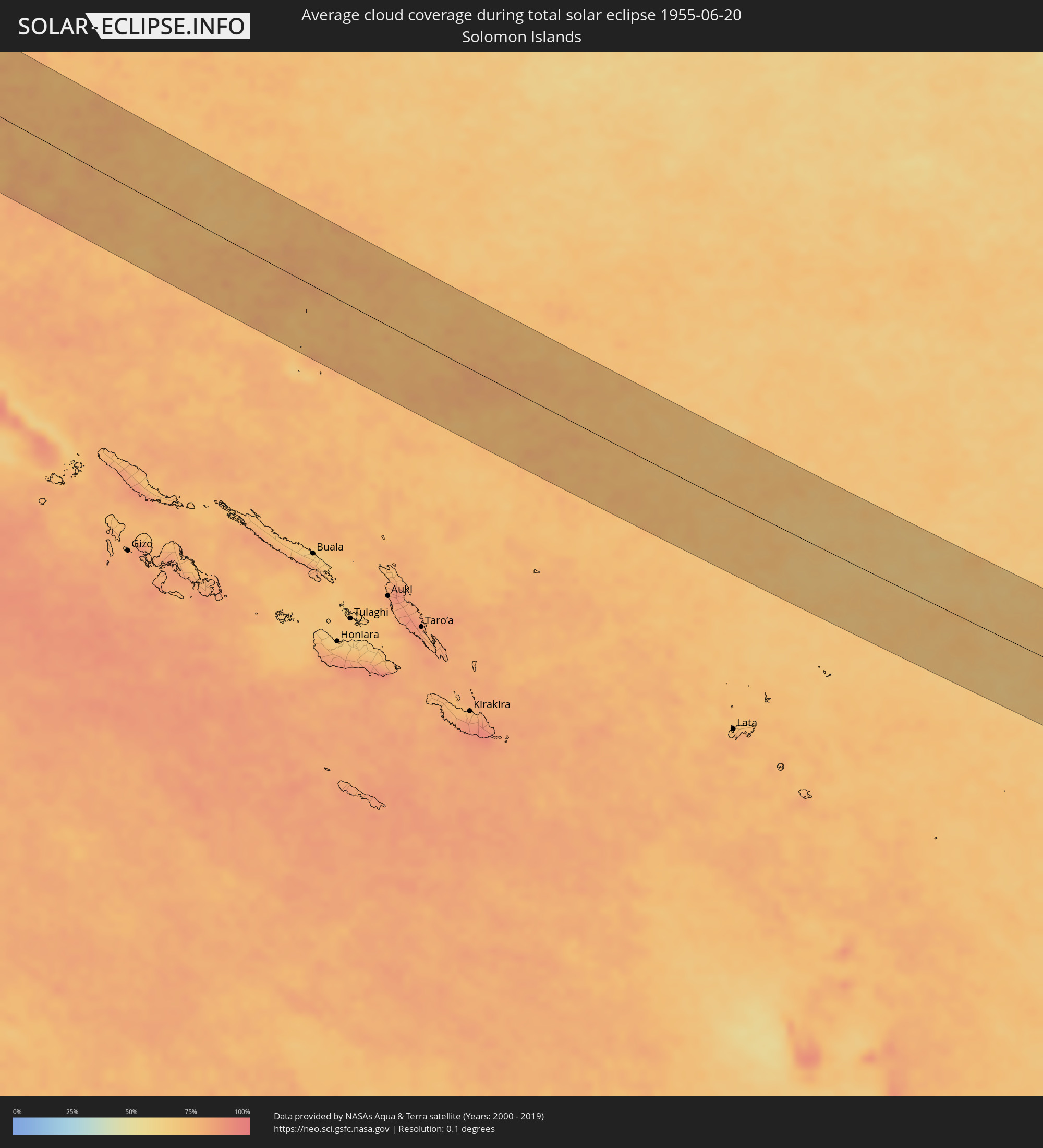 Solomon Islands
Cities inside the path of the eclipse
The following table shows all locations with a population of more than 5,000 inside the eclipse path. Cities which have more than 100,000 inhabitants are marked bold. A click at the locations opens a detailed map.
| City | Type | Eclipse duration | Local time of max. eclipse | Distance to central line | Ø Cloud coverage |
|
Eydhafushi, Baa Atholhu
|
total | - | 07:30:00 UTC+04:54 | 65 km | 89% |
|
Naifaru, Lhaviyani Atholhu
|
total | - | 07:30:21 UTC+04:54 | 86 km | 85% |
|
Male, Kaafu Atoll
|
total | - | 07:29:59 UTC+04:54 | 50 km | 85% |
|
Puttalam, North Western
|
total | - | 08:13:17 UTC+05:30 | 66 km | 89% |
|
Negombo, Western
|
total | - | 08:12:54 UTC+05:30 | 20 km | 86% |
|
Colombo, Western
|
total | - | 08:12:48 UTC+05:30 | 48 km | 84% |
|
Moratuwa, Western
|
total | - | 08:12:46 UTC+05:30 | 66 km | 87% |
|
Peliyagoda, Western
|
total | - | 08:12:51 UTC+05:30 | 46 km | 91% |
|
Wattala, Western
|
total | - | 08:12:52 UTC+05:30 | 45 km | 91% |
|
Ja Ela, Western
|
total | - | 08:12:55 UTC+05:30 | 36 km | 89% |
|
Kelaniya, Western
|
total | - | 08:12:53 UTC+05:30 | 49 km | 91% |
|
Kalutara, Western
|
total | - | 08:12:46 UTC+05:30 | 89 km | 86% |
|
Bentota, Southern
|
total | - | 08:12:45 UTC+05:30 | 107 km | 84% |
|
Homagama, Western
|
total | - | 08:12:56 UTC+05:30 | 64 km | 95% |
|
Ratnapura, Sabaragamuwa
|
total | - | 08:13:18 UTC+05:30 | 98 km | 91% |
|
Anuradhapura, North Central
|
total | - | 08:14:03 UTC+05:30 | 69 km | 89% |
|
Vavuniya, Northern Province
|
total | - | 08:14:22 UTC+05:30 | 111 km | 87% |
|
Kandy, Central
|
total | - | 08:13:50 UTC+05:30 | 45 km | 92% |
|
Dambulla, Central
|
total | - | 08:14:06 UTC+05:30 | 12 km | 85% |
|
Badulla, Uva
|
total | - | 08:14:11 UTC+05:30 | 94 km | 76% |
|
Trincomalee, Eastern Province
|
total | - | 08:15:07 UTC+05:30 | 61 km | 79% |
|
Batticaloa, Eastern Province
|
total | - | 08:15:15 UTC+05:30 | 47 km | 74% |
|
Kalmunai, Eastern Province
|
total | - | 08:15:17 UTC+05:30 | 84 km | 63% |
|
Bamboo Flat, Andaman and Nicobar Islands
|
total | - | 08:34:25 UTC+05:30 | 52 km | 94% |
|
Port Blair, Andaman and Nicobar Islands
|
total | - | 08:34:28 UTC+05:30 | 57 km | 94% |
|
Dawei, Tanintharyi
|
total | - | 09:47:11 UTC+06:30 | 44 km | 96% |
|
Kanchanaburi, Kanchanaburi
|
total | - | 10:20:21 UTC+07:00 | 3 km | 95% |
|
Tha Maka, Kanchanaburi
|
total | - | 10:20:50 UTC+07:00 | 14 km | 95% |
|
Ratchaburi, Ratchaburi
|
total | - | 10:20:50 UTC+07:00 | 54 km | 97% |
|
Ban Pong, Ratchaburi
|
total | - | 10:21:05 UTC+07:00 | 25 km | 95% |
|
Nakhon Pathom, Nakhon Pathom
|
total | - | 10:21:29 UTC+07:00 | 29 km | 97% |
|
Suphan Buri, Suphan Buri
|
total | - | 10:21:55 UTC+07:00 | 41 km | 96% |
|
Krathum Baen, Samut Sakhon
|
total | - | 10:21:58 UTC+07:00 | 52 km | 97% |
|
Pak Kret, Nonthaburi
|
total | - | 10:22:38 UTC+07:00 | 28 km | 97% |
|
Bangkok, Bangkok
|
total | - | 10:22:36 UTC+07:00 | 46 km | 97% |
|
Phra Nakhon Si Ayutthaya, Phra Nakhon Si Ayutthaya
|
total | - | 10:22:59 UTC+07:00 | 18 km | 96% |
|
Samut Prakan, Samut Prakan
|
total | - | 10:22:47 UTC+07:00 | 65 km | 94% |
|
Khlong Luang, Pathum Thani
|
total | - | 10:23:04 UTC+07:00 | 15 km | 96% |
|
Lop Buri, Lop Buri
|
total | - | 10:23:20 UTC+07:00 | 65 km | 96% |
|
Ban Lam Luk Ka, Pathum Thani
|
total | - | 10:23:21 UTC+07:00 | 27 km | 97% |
|
Phra Phutthabat, Sara Buri
|
total | - | 10:23:39 UTC+07:00 | 54 km | 97% |
|
Saraburi, Sara Buri
|
total | - | 10:23:54 UTC+07:00 | 31 km | 97% |
|
Si Racha, Chon Buri
|
total | - | 10:23:29 UTC+07:00 | 118 km | 92% |
|
Chon Buri, Chon Buri
|
total | - | 10:23:40 UTC+07:00 | 99 km | 95% |
|
Nakhon Ratchasima, Nakhon Ratchasima
|
total | - | 10:27:01 UTC+07:00 | 56 km | 94% |
|
Paôy Pêt, Banteay Meanchey
|
total | - | 10:27:50 UTC+07:00 | 97 km | 96% |
|
Sisŏphŏn, Banteay Meanchey
|
total | - | 10:28:55 UTC+07:00 | 112 km | 96% |
|
Sâmraông, Ŏtâr Méanchey
|
total | - | 10:30:31 UTC+07:00 | 55 km | 97% |
|
Ubon Ratchathani, Changwat Ubon Ratchathani
|
total | - | 10:34:20 UTC+07:00 | 42 km | 95% |
|
Tbêng Méanchey, Preah Vihear
|
total | - | 10:34:26 UTC+07:00 | 117 km | 96% |
|
Pakse, Champasak
|
total | - | 10:36:55 UTC+07:00 | 18 km | 95% |
|
Không, Champasak
|
total | - | 10:36:54 UTC+07:00 | 93 km | 93% |
|
Champasak, Champasak
|
total | - | 10:37:06 UTC+07:00 | 8 km | 93% |
|
Salavan, Salavan
|
total | - | 10:38:43 UTC+07:00 | 78 km | 94% |
|
Lamam, Xékong
|
total | - | 10:39:27 UTC+07:00 | 42 km | 90% |
|
Attapu, Attapu
|
total | - | 10:39:46 UTC+07:00 | 26 km | 89% |
|
Kon Tum, Kon Tum
|
total | - | 11:43:07 UTC+08:00 | 86 km | 90% |
|
Da Nang, Đà Nẵng
|
total | - | 11:43:48 UTC+08:00 | 103 km | 84% |
|
Hội An, Quảng Nam
|
total | - | 11:44:07 UTC+08:00 | 82 km | 80% |
|
Tam Kỳ, Quảng Nam
|
total | - | 11:44:31 UTC+08:00 | 47 km | 81% |
|
Quảng Ngãi, Quảng Ngãi
|
total | - | 11:45:25 UTC+08:00 | 5 km | 78% |
|
Olongapo, Central Luzon
|
total | - | 12:19:59 UTC+08:00 | 69 km | 87% |
|
Angeles City, Central Luzon
|
total | - | 12:20:40 UTC+08:00 | 111 km | 94% |
|
San Fernando, Central Luzon
|
total | - | 12:21:03 UTC+08:00 | 100 km | 90% |
|
Malolos, Central Luzon
|
total | - | 12:21:31 UTC+08:00 | 83 km | 85% |
|
Baliuag, Central Luzon
|
total | - | 12:21:42 UTC+08:00 | 97 km | 95% |
|
Cavite City, Calabarzon
|
total | - | 12:22:00 UTC+08:00 | 46 km | 87% |
|
Dasmariñas, Calabarzon
|
total | - | 12:22:13 UTC+08:00 | 30 km | 93% |
|
San Jose del Monte, Central Luzon
|
total | - | 12:22:14 UTC+08:00 | 85 km | 94% |
|
Quezon City, Metro Manila
|
total | - | 12:22:21 UTC+08:00 | 68 km | 87% |
|
Batangas, Calabarzon
|
total | - | 12:22:56 UTC+08:00 | 29 km | 89% |
|
Lipa City, Calabarzon
|
total | - | 12:23:08 UTC+08:00 | 6 km | 91% |
|
Calamba, Calabarzon
|
total | - | 12:22:58 UTC+08:00 | 23 km | 91% |
|
Binangonan, Calabarzon
|
total | - | 12:22:53 UTC+08:00 | 51 km | 77% |
|
Rodriguez, Calabarzon
|
total | - | 12:22:43 UTC+08:00 | 83 km | 91% |
|
San Pablo, Calabarzon
|
total | - | 12:23:32 UTC+08:00 | 11 km | 92% |
|
Santa Cruz, Calabarzon
|
total | - | 12:23:39 UTC+08:00 | 37 km | 85% |
|
Lucena, Calabarzon
|
total | - | 12:24:28 UTC+08:00 | 4 km | 80% |
|
Naga, Bicol
|
total | - | 12:29:14 UTC+08:00 | 13 km | 88% |
|
Iriga City, Bicol
|
total | - | 12:30:02 UTC+08:00 | 0 km | 86% |
|
Legaspi, Bicol
|
total | - | 12:31:11 UTC+08:00 | 21 km | 84% |
|
Kayangel, Kayangel
|
total | - | 14:03:38 UTC+09:00 | 105 km | 88% |