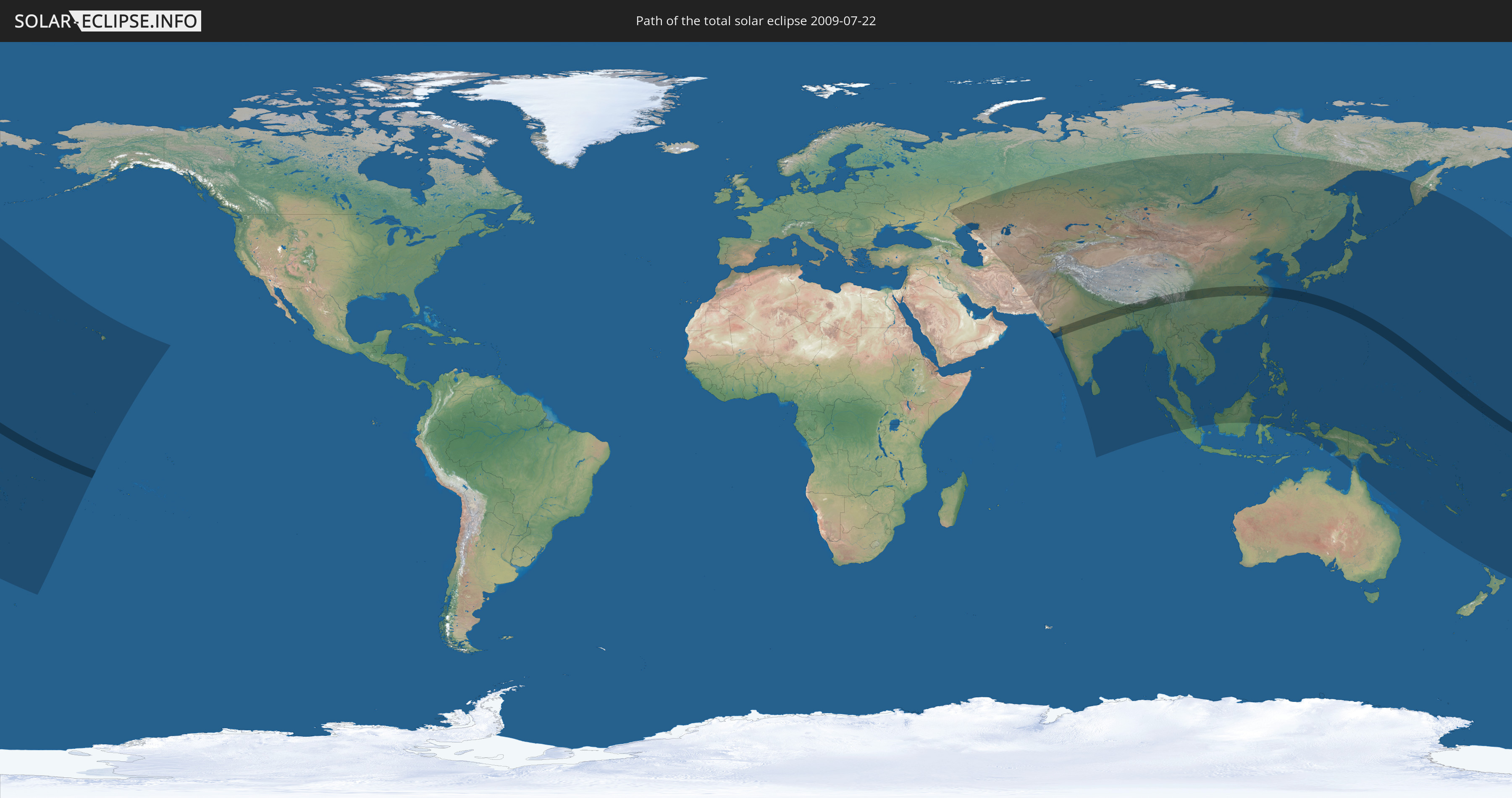
Total solar eclipse of 07/22/2009
340 people have seen this solar eclipse.
| Day of week: | Wednesday |
| Maximum duration of eclipse: | 06m39s |
| Maximum width of eclipse path: | 258 km |
| Saros cycle: | 136 |
| Coverage: | 100% |
| Magnitude: | 1.0799 |
| Gamma: | 0.0698 |
Wo kann man die Sonnenfinsternis vom 07/22/2009 sehen?
Die Sonnenfinsternis am 07/22/2009 kann man in 57 Ländern als partielle Sonnenfinsternis beobachten.
Der Finsternispfad verläuft durch 9 Länder. Nur in diesen Ländern ist sie als total Sonnenfinsternis zu sehen.
In den folgenden Ländern ist die Sonnenfinsternis total zu sehen
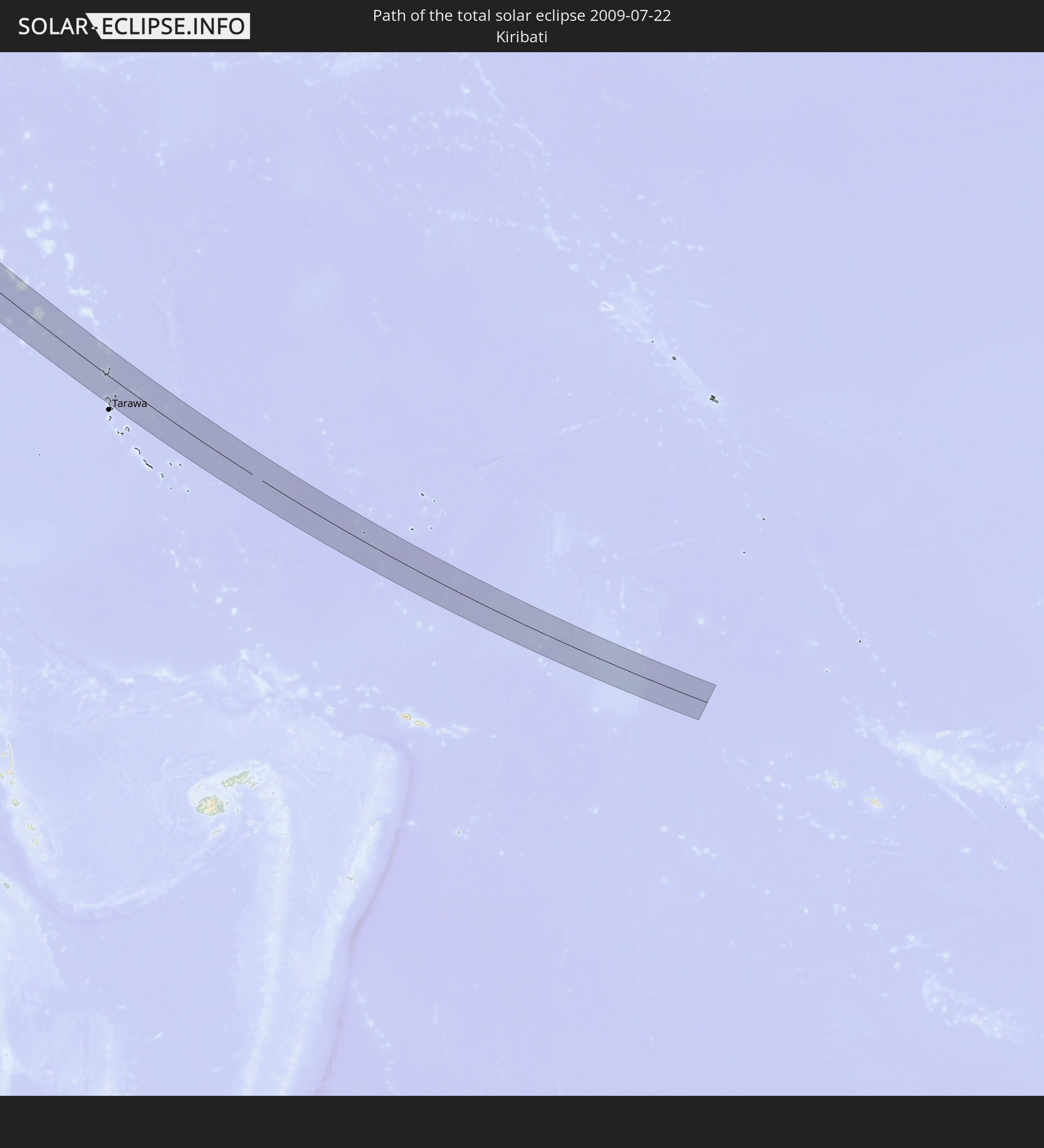 Kiribati
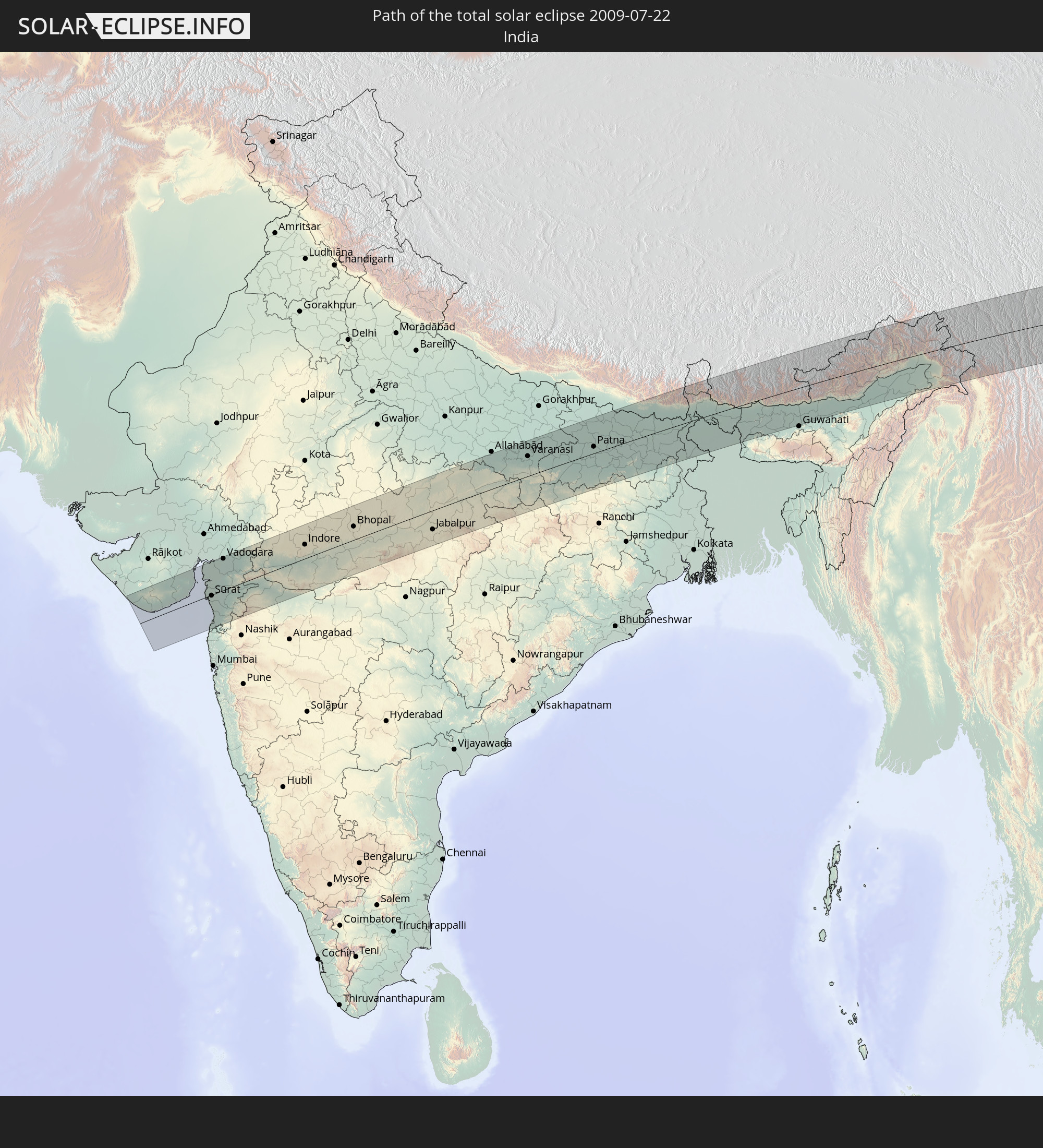 India
India
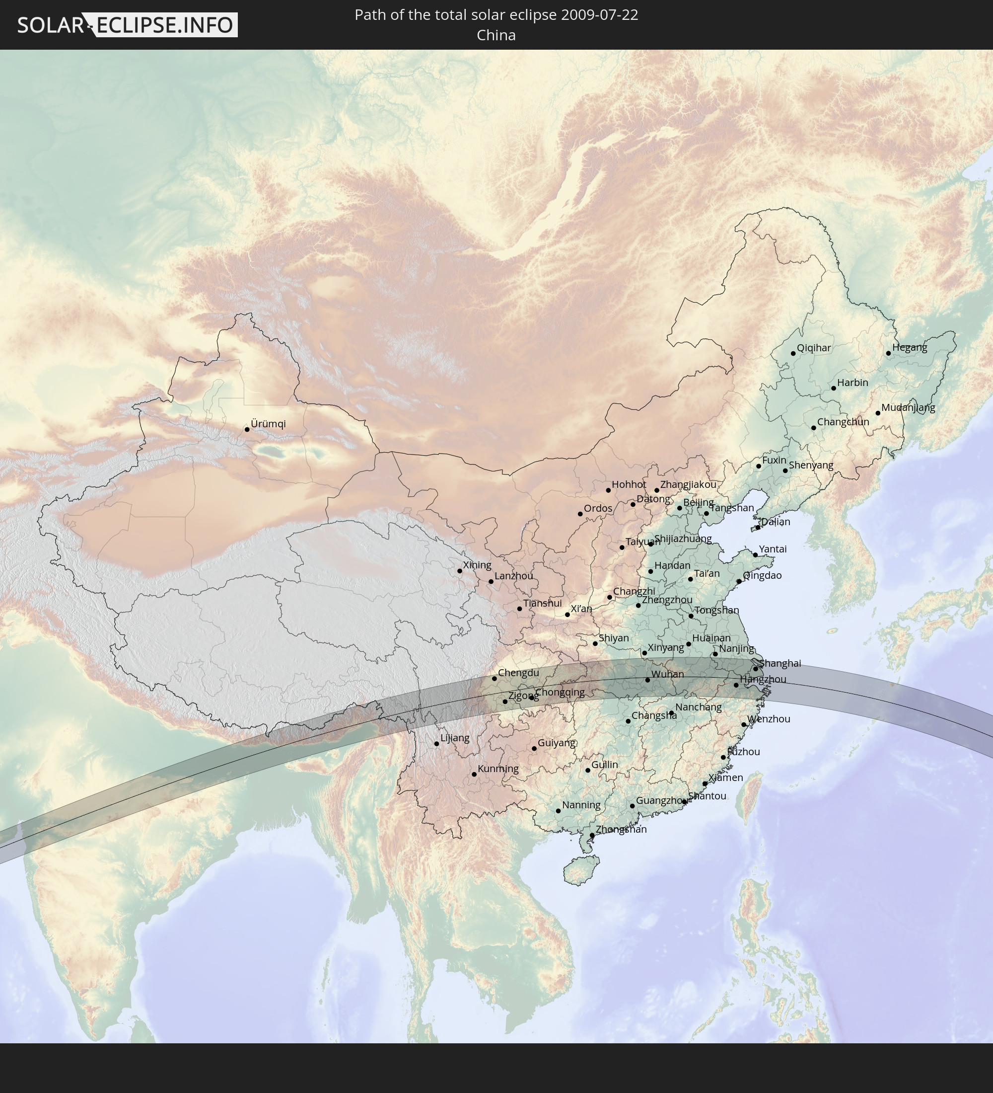 China
China
 Nepal
Nepal
 Bangladesh
 Bhutan
 Myanmar
 Japan
Japan
 Marshall Islands
In den folgenden Ländern ist die Sonnenfinsternis partiell zu sehen
 Russia
 Fiji
Fiji
 United States
 New Zealand
 United States Minor Outlying Islands
 Wallis and Futuna
 Tonga
Tonga
 Kiribati
 Samoa
Samoa
 Tokelau
 American Samoa
 Niue
Niue
 Cook Islands
 Iran
Iran
 Kazakhstan
 Turkmenistan
 Uzbekistan
 Afghanistan
 Pakistan
 Tajikistan
 India
India
 Kyrgyzstan
 China
China
 Sri Lanka
 Nepal
Nepal
 Mongolia
 Bangladesh
 Bhutan
 Myanmar
 Indonesia
 Thailand
 Malaysia
 Laos
Laos
 Vietnam
 Cambodia
 Singapore
 Australia
 Macau
Macau
 Hong Kong
 Brunei
 Taiwan
 Philippines
 Japan
Japan
 North Korea
 South Korea
 Palau
Palau
 Federated States of Micronesia
 Papua New Guinea
 Guam
Guam
 Northern Mariana Islands
 Solomon Islands
 New Caledonia
 Marshall Islands
 Vanuatu
 Nauru
Nauru
 Norfolk Island
 Tuvalu
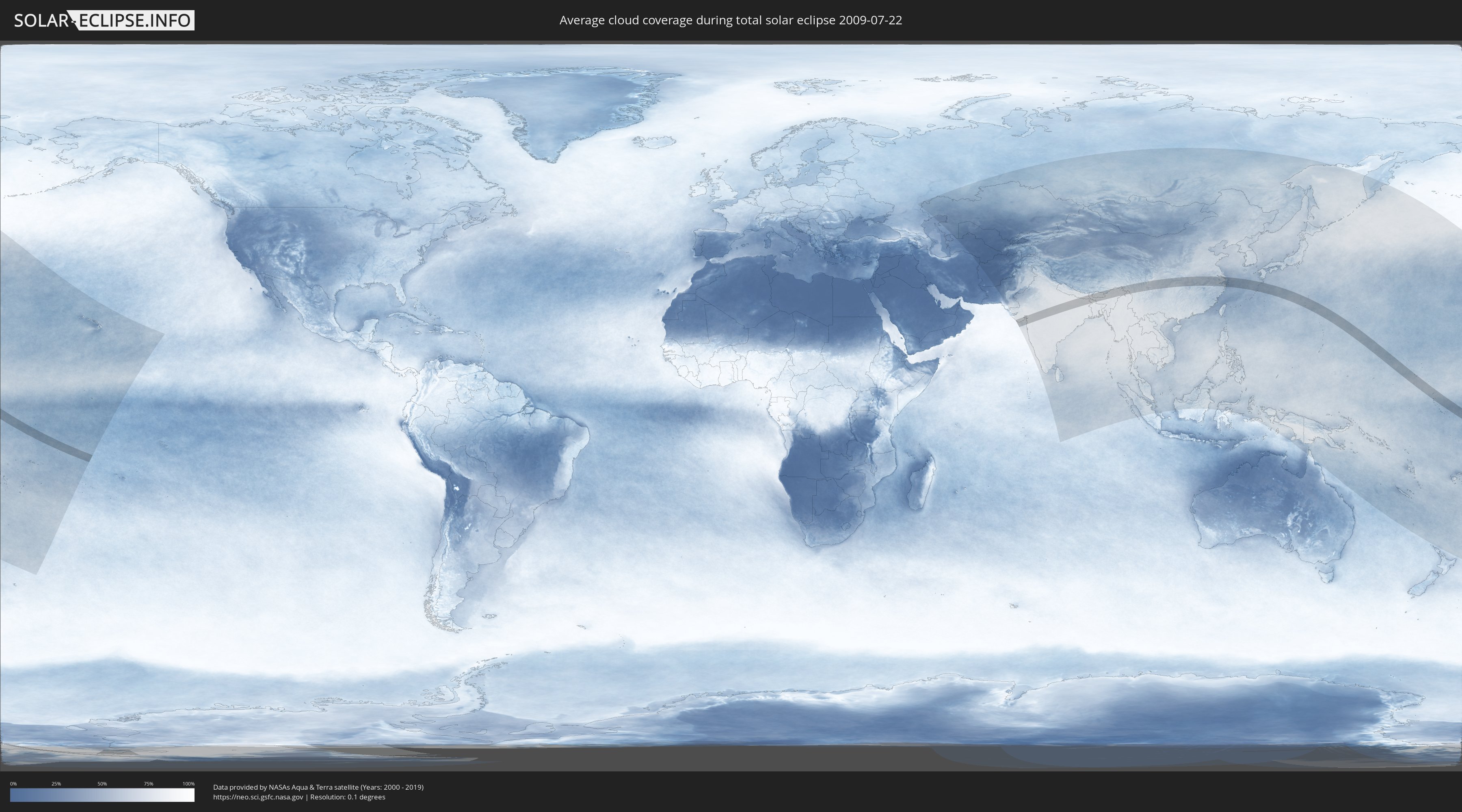
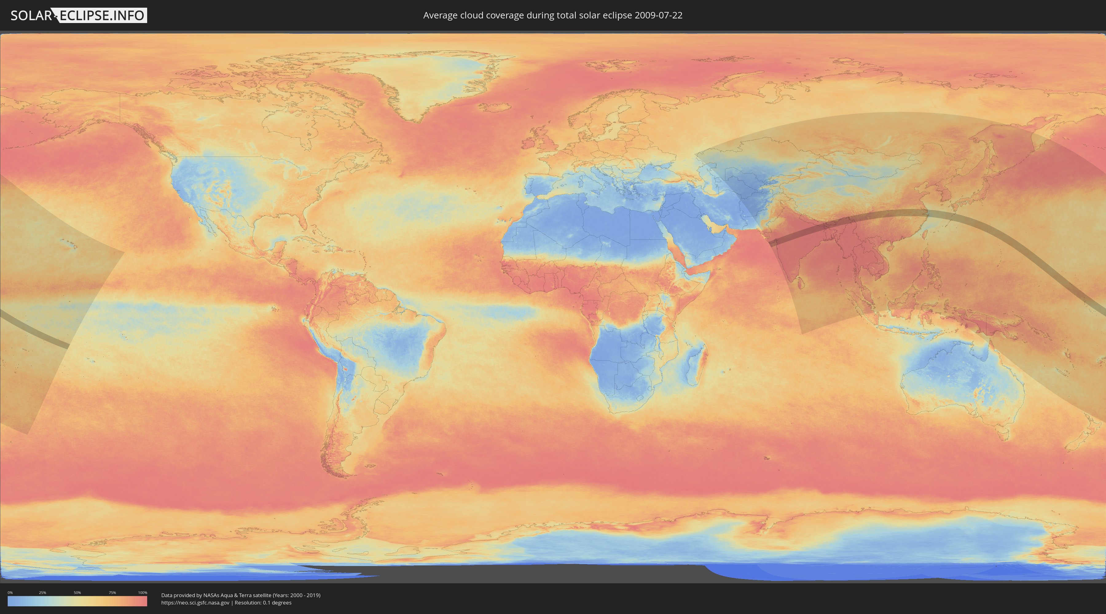
How will be the weather during the total solar eclipse on 07/22/2009?
Where is the best place to see the total solar eclipse of 07/22/2009?
The following maps show the average cloud coverage for the day of the total solar eclipse.
With the help of these maps, it is possible to find the place along the eclipse path, which has the best
chance of a cloudless sky.
Nevertheless, you should consider local circumstances and inform about the weather of your chosen
observation site.
The data is provided by NASAs satellites
AQUA and TERRA.
The cloud maps are averaged over a period of 19 years (2000 - 2019).
Detailed country maps
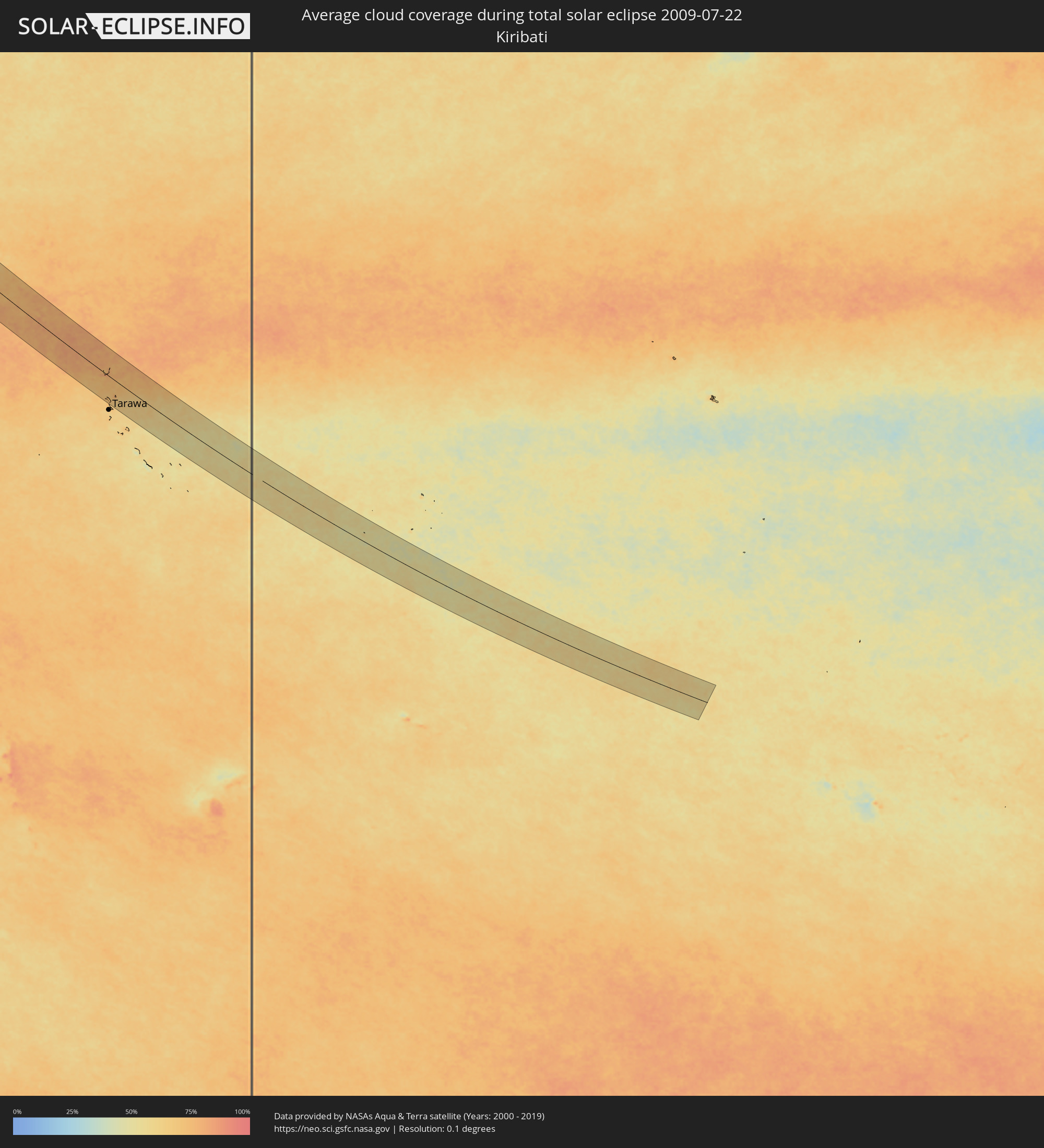 Kiribati
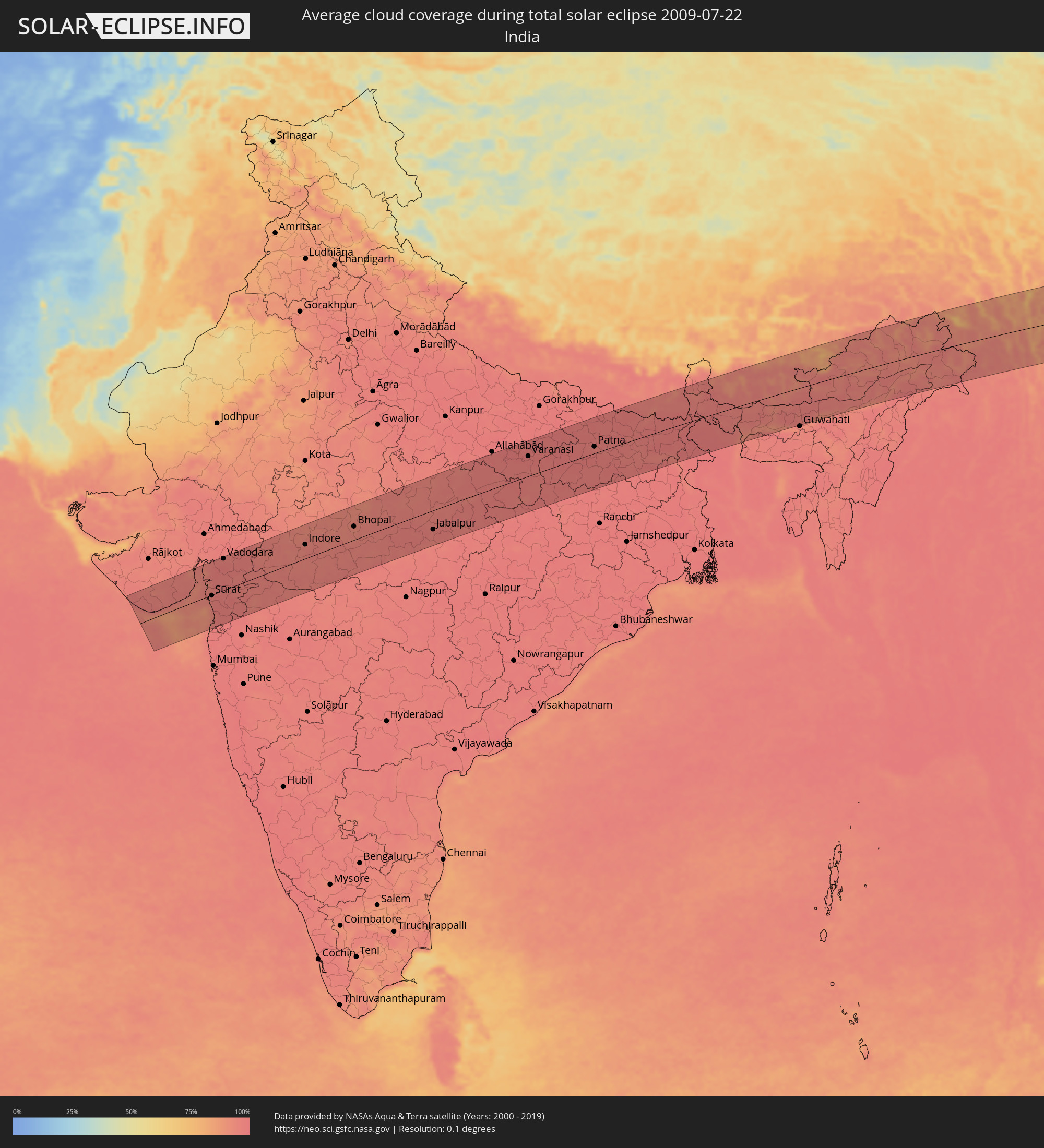 India
India
 China
China
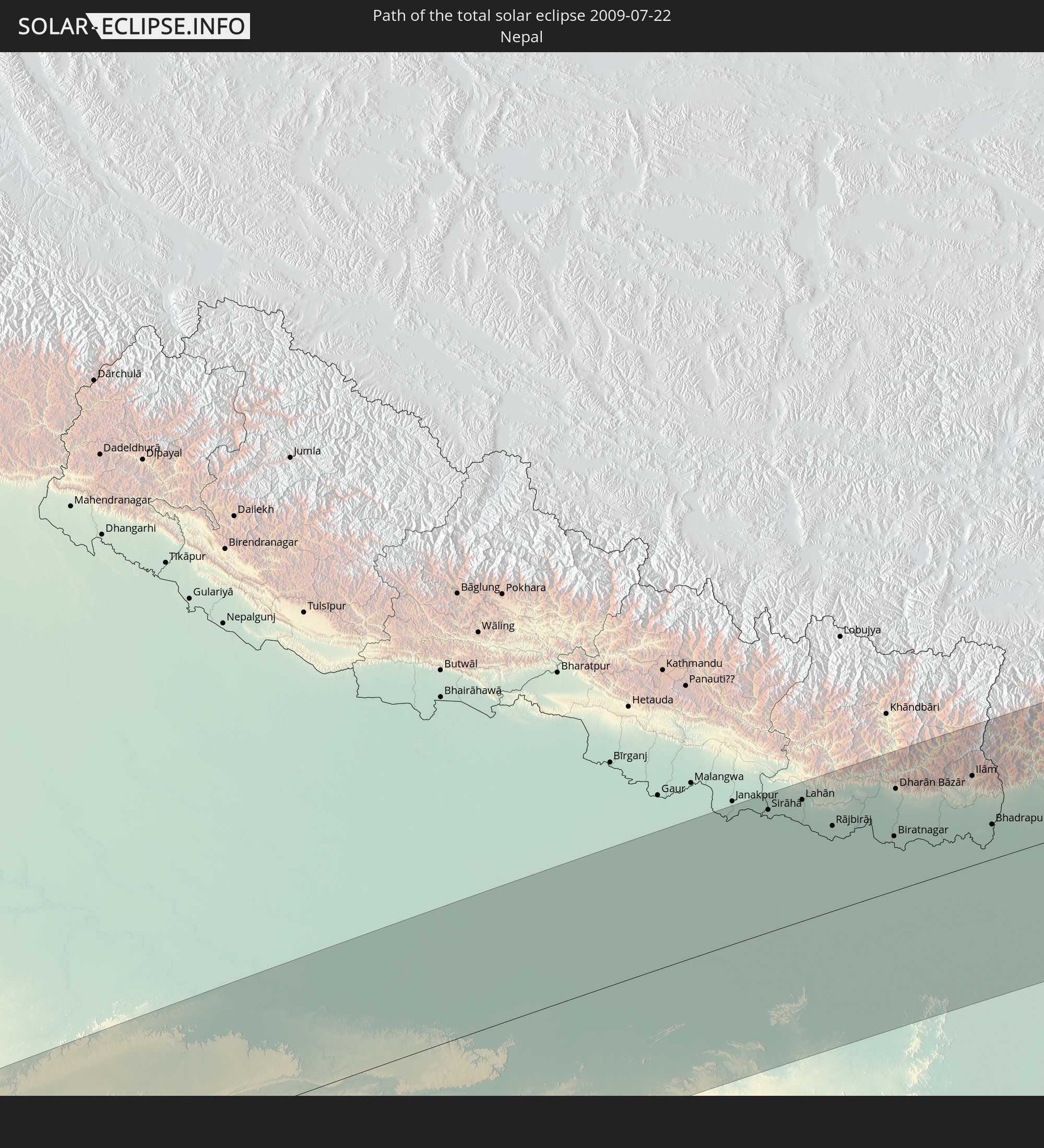
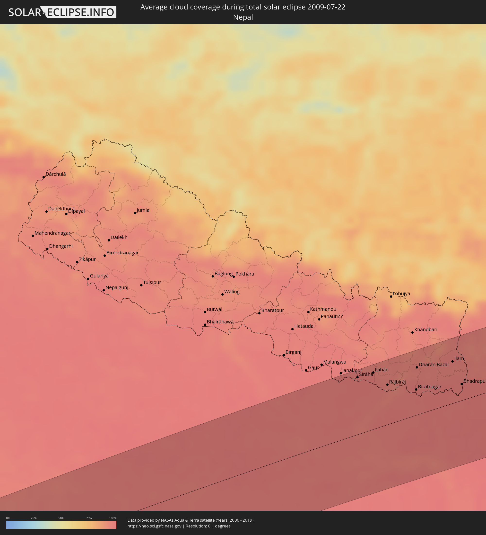 Nepal
Nepal
 Bangladesh
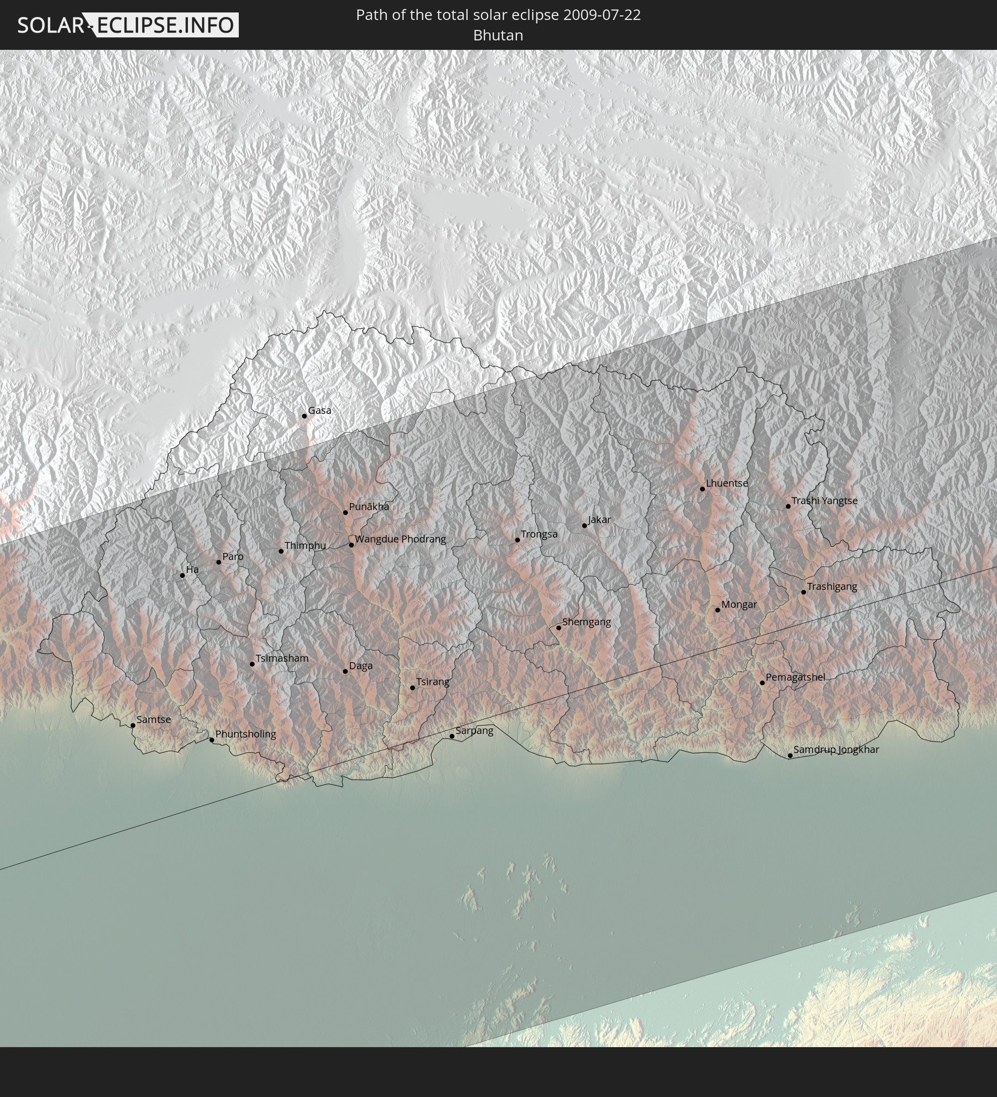
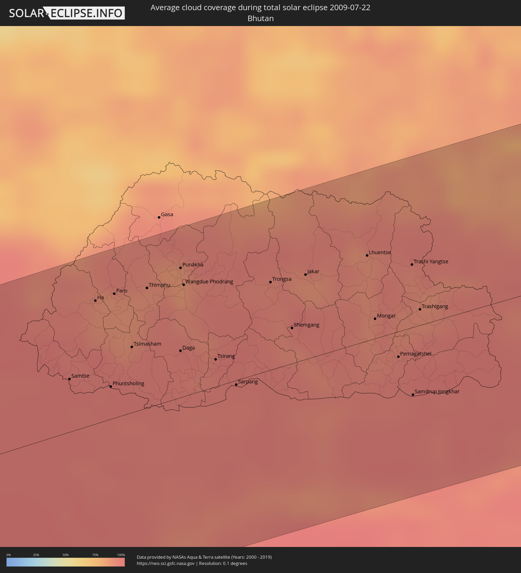 Bhutan
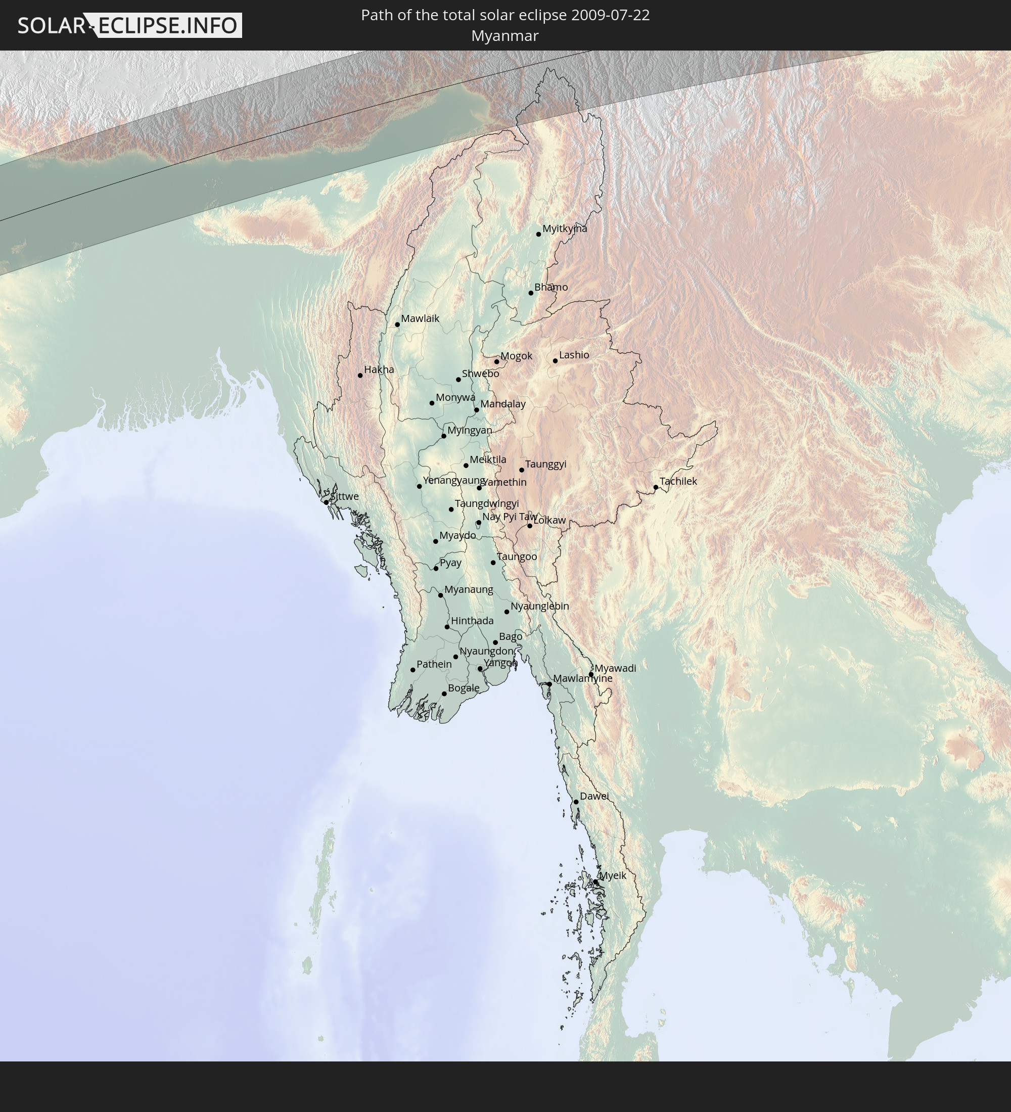
 Myanmar
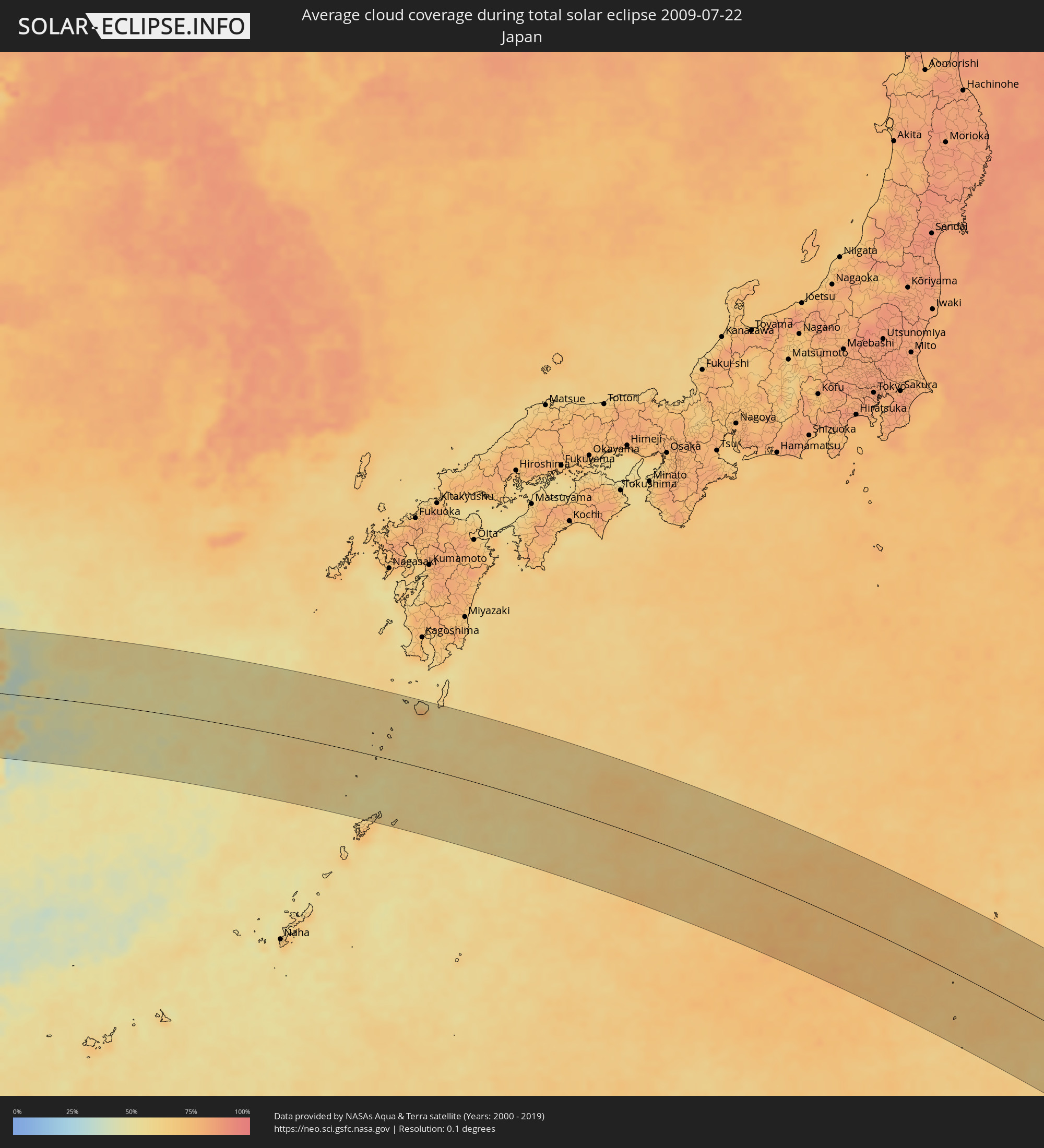 Japan
Japan
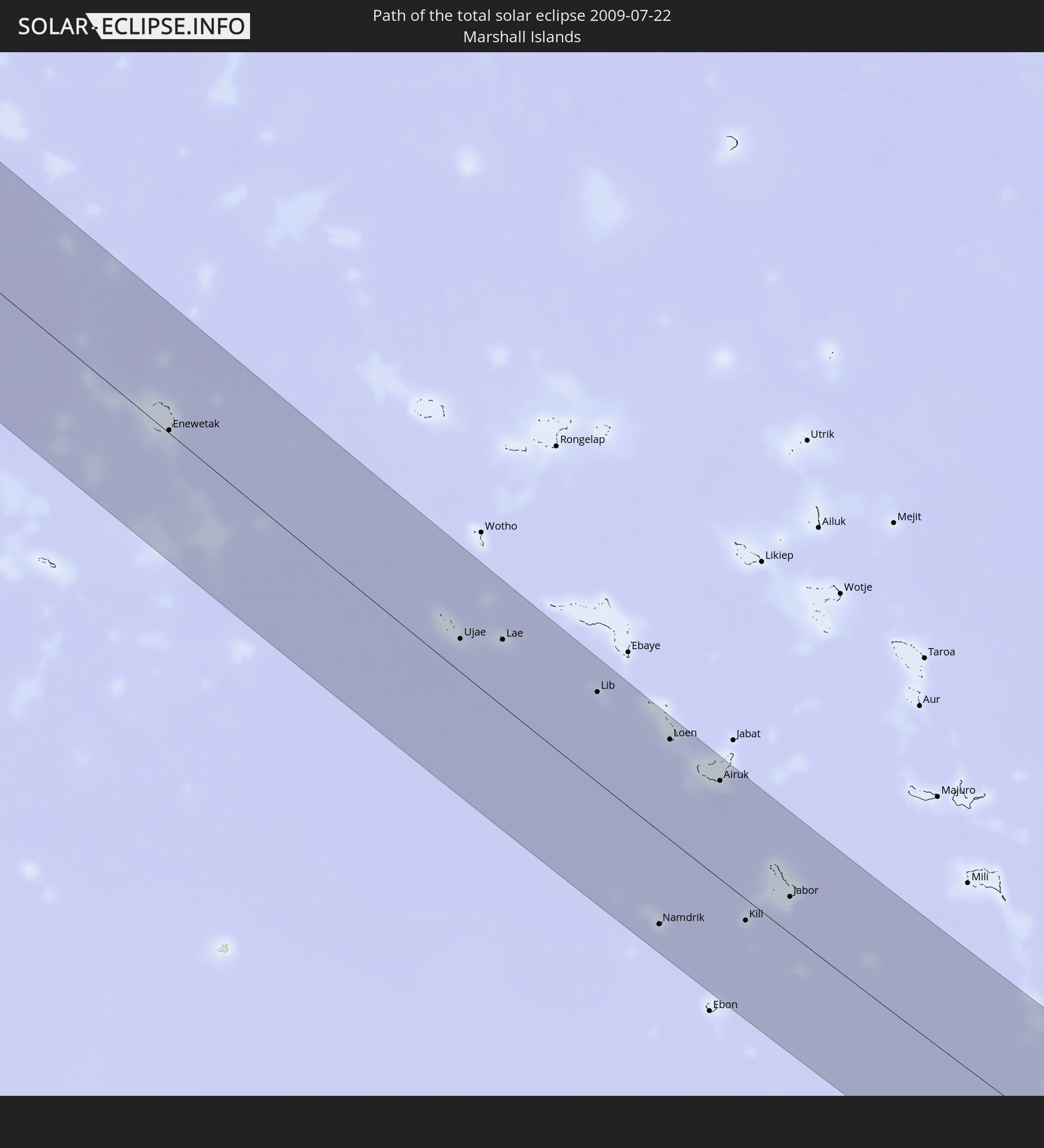
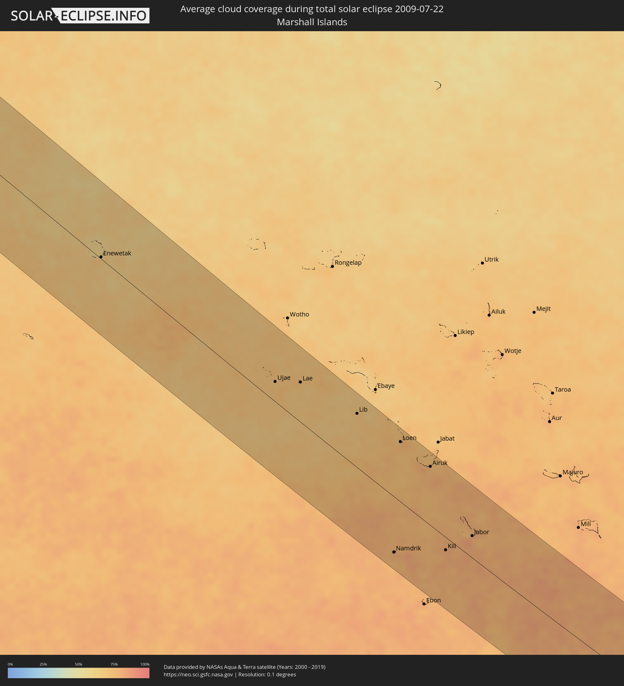 Marshall Islands
Cities inside the path of the eclipse
The following table shows all locations with a population of more than 5,000 inside the eclipse path. Cities which have more than 100,000 inhabitants are marked bold. A click at the locations opens a detailed map.
| City | Type | Eclipse duration | Local time of max. eclipse | Distance to central line | Ø Cloud coverage |
|
Bhāvnagar, Gujarat
|
total | - | 06:23:12 UTC+05:30 | 83 km | 95% |
|
Sūrat, Gujarat
|
total | - | 06:22:55 UTC+05:30 | 2 km | 95% |
|
Bilimora, Gujarat
|
total | - | 06:22:45 UTC+05:30 | 52 km | 97% |
|
Vadodara, Gujarat
|
total | - | 06:23:20 UTC+05:30 | 98 km | 97% |
|
Māndu, Madhya Pradesh
|
total | - | 06:23:19 UTC+05:30 | 23 km | 94% |
|
Ujjain, Madhya Pradesh
|
total | - | 06:23:41 UTC+05:30 | 93 km | 92% |
|
Indore, Madhya Pradesh
|
total | - | 06:23:29 UTC+05:30 | 43 km | 95% |
|
Dewas, Madhya Pradesh
|
total | - | 06:23:36 UTC+05:30 | 60 km | 93% |
|
Punāsa, Madhya Pradesh
|
total | - | 06:23:17 UTC+05:30 | 28 km | 94% |
|
Bhopal, Madhya Pradesh
|
total | - | 06:23:48 UTC+05:30 | 41 km | 92% |
|
Saugor, Madhya Pradesh
|
total | - | 06:24:12 UTC+05:30 | 54 km | 96% |
|
Jabalpur, Madhya Pradesh
|
total | - | 06:24:03 UTC+05:30 | 59 km | 96% |
|
Murwāra, Madhya Pradesh
|
total | - | 06:24:26 UTC+05:30 | 4 km | 95% |
|
Satna, Madhya Pradesh
|
total | - | 06:24:52 UTC+05:30 | 58 km | 96% |
|
Rewa, Madhya Pradesh
|
total | - | 06:24:56 UTC+05:30 | 37 km | 97% |
|
Mirzāpur, Uttar Pradesh
|
total | - | 06:25:32 UTC+05:30 | 58 km | 97% |
|
Varanasi, Uttar Pradesh
|
total | - | 06:25:44 UTC+05:30 | 61 km | 97% |
|
Mau, Uttar Pradesh
|
total | - | 06:26:12 UTC+05:30 | 108 km | 97% |
|
Arrah, Bihar
|
total | - | 06:26:20 UTC+05:30 | 32 km | 97% |
|
Chāpra, Bihar
|
total | - | 06:26:29 UTC+05:30 | 52 km | 97% |
|
Gaya, Bihar
|
total | - | 06:26:04 UTC+05:30 | 60 km | 97% |
|
Patna, Bihar
|
total | - | 06:26:31 UTC+05:30 | 20 km | 97% |
|
Muzaffarpur, Bihar
|
total | - | 06:26:53 UTC+05:30 | 68 km | 97% |
|
Bihār Sharīf, Bihar
|
total | - | 06:26:27 UTC+05:30 | 34 km | 97% |
|
Jaleswar, Central Region
|
total | - | 06:42:19 UTC+05:45 | 110 km | 97% |
|
Darbhanga, Bihar
|
total | - | 06:27:05 UTC+05:30 | 55 km | 97% |
|
Sirāhā, Eastern Region
|
total | - | 06:42:28 UTC+05:45 | 98 km | 97% |
|
Monghyr, Bihar
|
total | - | 06:26:54 UTC+05:30 | 46 km | 96% |
|
Lahān, Eastern Region
|
total | - | 06:42:37 UTC+05:45 | 97 km | 97% |
|
Rājbirāj, Eastern Region
|
total | - | 06:42:37 UTC+05:45 | 68 km | 95% |
|
Bhāgalpur, Bihar
|
total | - | 06:27:02 UTC+05:30 | 75 km | 97% |
|
Biratnagar, Eastern Region
|
total | - | 06:42:47 UTC+05:45 | 44 km | 97% |
|
Ithari, Eastern Region
|
total | - | 06:42:54 UTC+05:45 | 66 km | 97% |
|
Dharān Bāzār, Eastern Region
|
total | - | 06:42:59 UTC+05:45 | 81 km | 95% |
|
Dhankutā, Eastern Region
|
total | - | 06:43:06 UTC+05:45 | 98 km | 95% |
|
Purnia, Bihar
|
total | - | 06:27:31 UTC+05:30 | 34 km | 98% |
|
Ilām, Eastern Region
|
total | - | 06:43:19 UTC+05:45 | 71 km | 96% |
|
Bhadrapur, Eastern Region
|
total | - | 06:43:11 UTC+05:45 | 28 km | 97% |
|
Pīrgaaj, Rangpur Division
|
total | - | 07:57:57 UTC+07:00 | 53 km | 98% |
|
Shiliguri, West Bengal
|
total | - | 06:28:26 UTC+05:30 | 35 km | 97% |
|
Thākurgaon, Rangpur Division
|
total | - | 07:58:05 UTC+07:00 | 38 km | 98% |
|
Panchagarh, Rangpur Division
|
total | - | 07:58:17 UTC+07:00 | 9 km | 97% |
|
Dinājpur, Rangpur Division
|
total | - | 07:57:58 UTC+07:00 | 86 km | 98% |
|
Saidpur, Rājshāhi
|
total | - | 07:58:09 UTC+07:00 | 78 km | 98% |
|
Parbatipur, Rangpur Division
|
total | - | 07:58:07 UTC+07:00 | 91 km | 98% |
|
Badarganj, Rangpur Division
|
total | - | 07:58:11 UTC+07:00 | 94 km | 98% |
|
Samtse, Samchi
|
total | - | 06:58:51 UTC+06:00 | 35 km | 97% |
|
Rangpur, Rangpur Division
|
total | - | 07:58:19 UTC+07:00 | 92 km | 98% |
|
Ha, Haa District
|
total | - | 06:59:13 UTC+06:00 | 82 km | 90% |
|
Phuntsholing, Chukha District
|
total | - | 06:28:58 UTC+05:30 | 21 km | 97% |
|
Paro, Paro
|
total | - | 06:59:18 UTC+06:00 | 82 km | 88% |
|
Lalmanirhat, Rangpur Division
|
total | - | 07:58:30 UTC+07:00 | 80 km | 97% |
|
Tsimasham, Chukha District
|
total | - | 06:59:11 UTC+06:00 | 43 km | 95% |
|
Thimphu, Thimphu
|
total | - | 06:59:26 UTC+06:00 | 79 km | 89% |
|
Lungtenzampa, Thimphu
|
total | - | 06:59:26 UTC+06:00 | 80 km | 89% |
|
Nageswari, Rangpur Division
|
total | - | 07:58:39 UTC+07:00 | 81 km | 96% |
|
Daga, Dagana District
|
total | - | 06:59:20 UTC+06:00 | 31 km | 95% |
|
Punākha, Punakha
|
total | - | 06:59:38 UTC+06:00 | 86 km | 87% |
|
Wangdue Phodrang, Wangdi Phodrang
|
total | - | 06:59:35 UTC+06:00 | 74 km | 87% |
|
Tsirang, Chirang
|
total | - | 06:59:26 UTC+06:00 | 18 km | 94% |
|
Sarpang, Geylegphug
|
total | - | 06:59:26 UTC+06:00 | 3 km | 95% |
|
Trongsa, Tongsa
|
total | - | 06:59:55 UTC+06:00 | 58 km | 92% |
|
Shemgang, Shemgang
|
total | - | 06:59:50 UTC+06:00 | 23 km | 91% |
|
Jakar, Bumthang
|
total | - | 07:00:04 UTC+06:00 | 56 km | 89% |
|
Lhuentse, Lhuntse District
|
total | - | 07:00:23 UTC+06:00 | 57 km | 89% |
|
Mongar, Mongar District
|
total | - | 07:00:12 UTC+06:00 | 13 km | 90% |
|
Pemagatshel, Pemagatshel District
|
total | - | 07:00:10 UTC+06:00 | 17 km | 96% |
|
Trashi Yangtse, Trashi Yangste
|
total | - | 07:00:32 UTC+06:00 | 42 km | 91% |
|
Samdrup Jongkhar, Samdrup Jongkhar
|
total | - | 07:00:06 UTC+06:00 | 45 km | 96% |
|
Trashigang, Tashigang
|
total | - | 07:00:25 UTC+06:00 | 10 km | 96% |
|
Chengdu, Sichuan
|
total | - | 09:12:48 UTC+08:00 | 90 km | 87% |
|
Zigong, Sichuan
|
total | - | 09:13:00 UTC+08:00 | 67 km | 84% |
|
Neijiang, Sichuan
|
total | - | 09:13:27 UTC+08:00 | 45 km | 81% |
|
Nanchong, Sichuan
|
total | - | 09:15:12 UTC+08:00 | 73 km | 77% |
|
Chongqing, Chongqing
|
total | - | 09:15:16 UTC+08:00 | 69 km | 80% |
|
Yichang, Hubei
|
total | - | 09:22:06 UTC+08:00 | 8 km | 80% |
|
Shashi, Hubei
|
total | - | 09:23:25 UTC+08:00 | 43 km | 70% |
|
Jingling, Hubei
|
total | - | 09:24:49 UTC+08:00 | 10 km | 75% |
|
Suizhou, Hubei
|
total | - | 09:25:29 UTC+08:00 | 107 km | 78% |
|
Xiantao, Hubei
|
total | - | 09:25:18 UTC+08:00 | 43 km | 73% |
|
Chengzhong, Hubei
|
total | - | 09:25:36 UTC+08:00 | 21 km | 66% |
|
Wuhan, Hubei
|
total | - | 09:26:39 UTC+08:00 | 22 km | 77% |
|
Ezhou, Hubei
|
total | - | 09:27:32 UTC+08:00 | 44 km | 67% |
|
Huangshi, Hubei
|
total | - | 09:27:52 UTC+08:00 | 62 km | 74% |
|
Wuxue, Hubei
|
total | - | 09:28:39 UTC+08:00 | 107 km | 70% |
|
Anqing, Anhui
|
total | - | 09:31:17 UTC+08:00 | 33 km | 63% |
|
Hefei, Anhui
|
total | - | 09:31:49 UTC+08:00 | 117 km | 77% |
|
Wusong, Anhui
|
total | - | 09:32:36 UTC+08:00 | 16 km | 70% |
|
Wuhu, Anhui
|
total | - | 09:33:39 UTC+08:00 | 61 km | 68% |
|
Changzhou, Jiangsu
|
total | - | 09:36:29 UTC+08:00 | 116 km | 77% |
|
Hangzhou, Zhejiang
|
total | - | 09:36:54 UTC+08:00 | 47 km | 68% |
|
Wuxi, Jiangsu
|
total | - | 09:37:05 UTC+08:00 | 95 km | 73% |
|
Shaoxing, Zhejiang
|
total | - | 09:37:42 UTC+08:00 | 77 km | 69% |
|
Suzhou, Jiangsu
|
total | - | 09:37:39 UTC+08:00 | 68 km | 73% |
|
Changshu City, Jiangsu
|
total | - | 09:37:55 UTC+08:00 | 107 km | 70% |
|
Jiaxing, Zhejiang
|
total | - | 09:37:58 UTC+08:00 | 7 km | 72% |
|
Shangyu, Zhejiang
|
total | - | 09:38:16 UTC+08:00 | 74 km | 61% |
|
Shanghai, Shanghai
|
total | - | 09:39:16 UTC+08:00 | 65 km | 72% |
|
Ningbo, Zhejiang
|
total | - | 09:39:35 UTC+08:00 | 84 km | 69% |
|
Naze, Kagoshima
|
total | - | 10:56:52 UTC+09:00 | 125 km | 70% |
|
Enewetak, Enewetak Atoll
|
total | - | 15:31:30 UTC+12:00 | 3 km | 67% |
|
Ujae, Ujae Atoll
|
total | - | 15:39:58 UTC+12:00 | 33 km | 72% |
|
Lae, Lae Atoll
|
total | - | 15:40:37 UTC+12:00 | 67 km | 70% |
|
Lib, Lib Island
|
total | - | 15:42:53 UTC+12:00 | 91 km | 71% |
|
Namdrik, Namdrik Atoll
|
total | - | 15:47:36 UTC+12:00 | 95 km | 80% |
|
Loen, Namu Atoll
|
total | - | 15:44:42 UTC+12:00 | 102 km | 74% |
|
Airuk, Ailinglaplap Atoll
|
total | - | 15:46:04 UTC+12:00 | 101 km | 77% |
|
Kili, Kili Island
|
total | - | 15:48:40 UTC+12:00 | 22 km | 78% |
|
Jabor, Jaluit Atoll
|
total | - | 15:48:51 UTC+12:00 | 38 km | 82% |