Hybrid solar eclipse of 12/06/2067
| Day of week: | Tuesday |
| Maximum duration of eclipse: | 00m08s |
| Maximum width of eclipse path: | 4 km |
| Saros cycle: | 143 |
| Coverage: | 100% |
| Magnitude: | 1.0011 |
| Gamma: | 0.2845 |
Wo kann man die Sonnenfinsternis vom 12/06/2067 sehen?
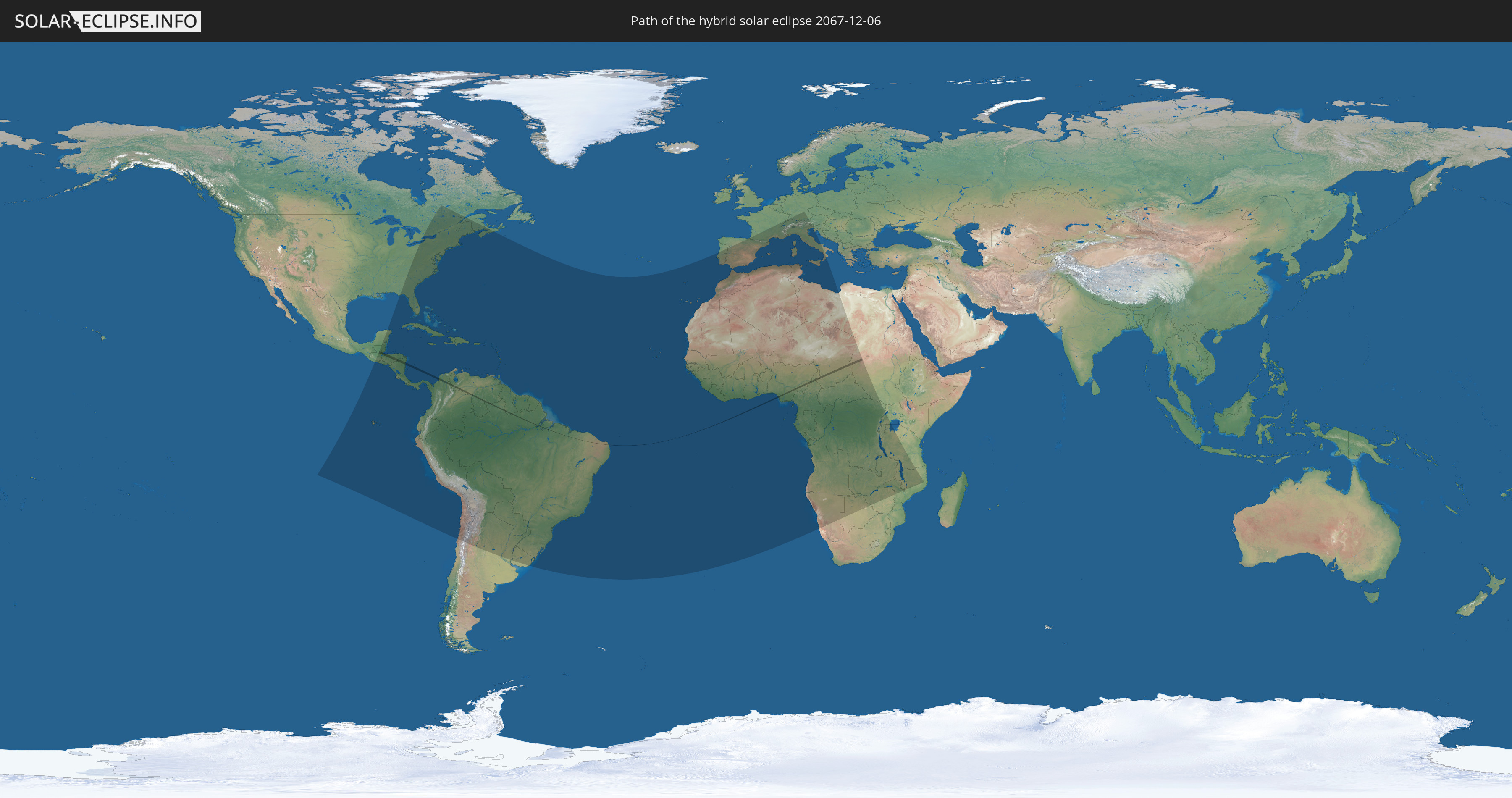
Die Sonnenfinsternis am 12/06/2067 kann man in 107 Ländern als partielle Sonnenfinsternis beobachten.
Der Finsternispfad verläuft durch 12 Länder. Nur in diesen Ländern ist sie als hybrid Sonnenfinsternis zu sehen.
In den folgenden Ländern ist die Sonnenfinsternis hybrid zu sehen
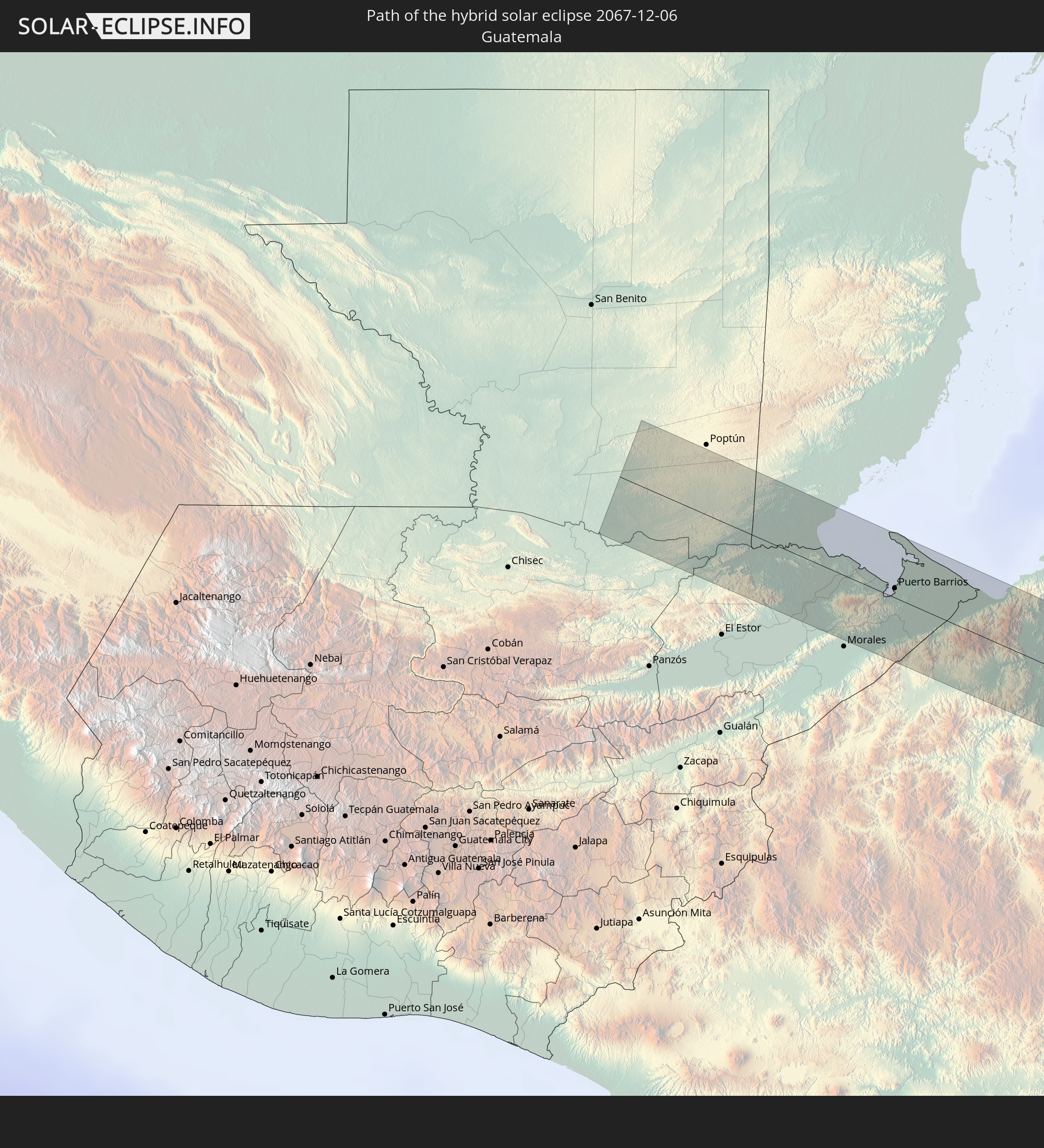 Guatemala
 Honduras
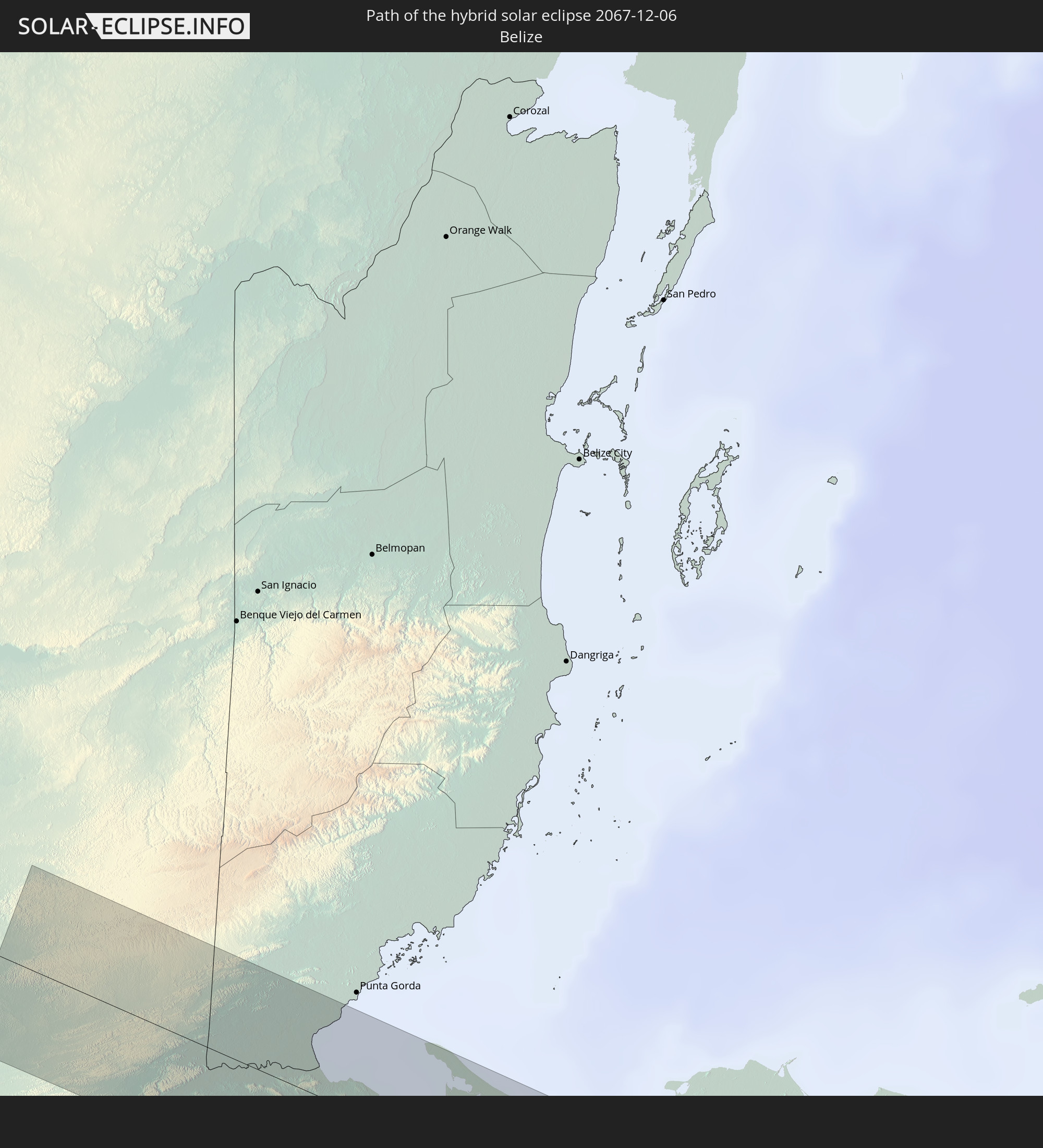 Belize
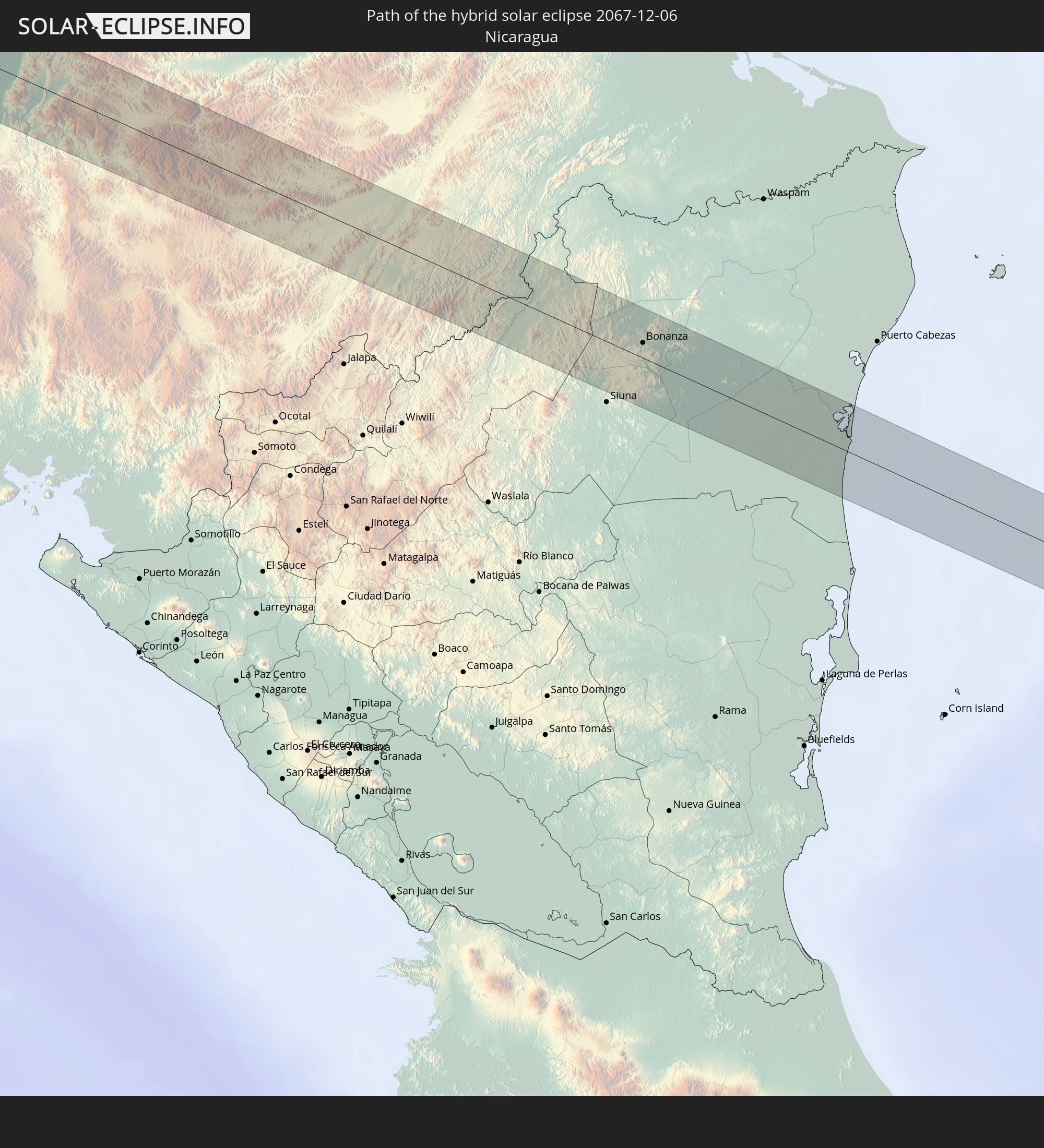 Nicaragua
 Colombia
 Brazil
 Venezuela
 Guyana
 Nigeria
 Cameroon
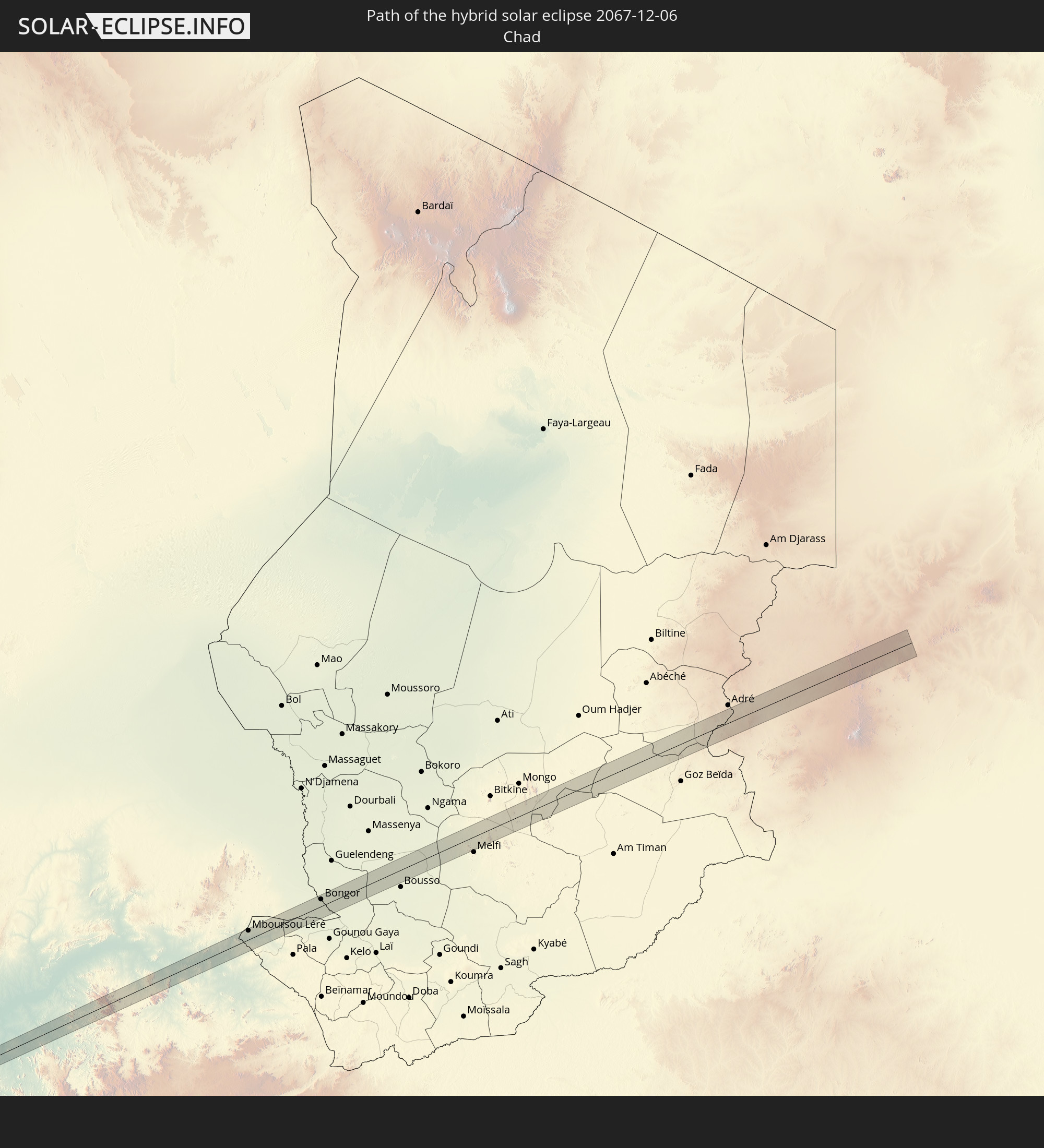 Chad
Chad
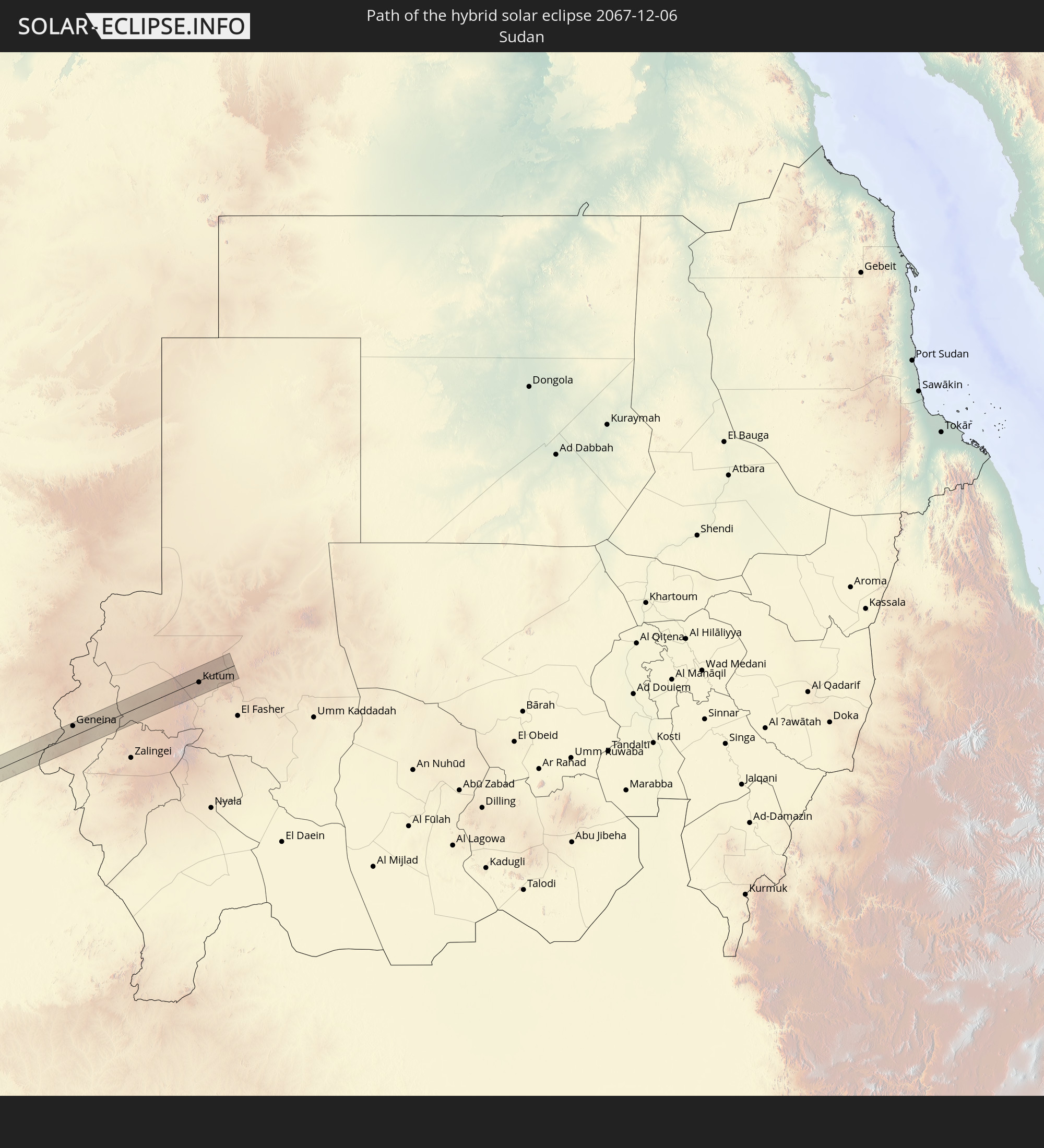 Sudan
Sudan
In den folgenden Ländern ist die Sonnenfinsternis partiell zu sehen
 United States
 United States Minor Outlying Islands
 Canada
 Mexico
 Chile
Chile
 Guatemala
 Ecuador
 El Salvador
 Honduras
 Belize
 Nicaragua
 Costa Rica
 Cuba
Cuba
 Panama
 Colombia
 Cayman Islands
 Peru
Peru
 The Bahamas
 Jamaica
 Haiti
Haiti
 Brazil
 Argentina
 Venezuela
 Turks and Caicos Islands
 Dominican Republic
 Aruba
Aruba
 Bolivia
 Puerto Rico
 United States Virgin Islands
 Bermuda
 British Virgin Islands
 Anguilla
 Collectivity of Saint Martin
 Saint Barthélemy
 Saint Kitts and Nevis
 Paraguay
 Antigua and Barbuda
 Montserrat
 Trinidad and Tobago
 Guadeloupe
 Grenada
 Dominica
 Saint Vincent and the Grenadines
 Guyana
 Martinique
 Saint Lucia
 Barbados
 Uruguay
 Suriname
 French Guiana
 Portugal
 Cabo Verde
 Spain
Spain
 Senegal
 Mauritania
 The Gambia
 Guinea-Bissau
 Guinea
 Saint Helena, Ascension and Tristan da Cunha
 Sierra Leone
 Morocco
 Mali
Mali
 Liberia
 Algeria
 Ivory Coast
 Burkina Faso
 Gibraltar
 France
 Ghana
Ghana
 Togo
Togo
 Niger
Niger
 Benin
Benin
 Andorra
 Nigeria
 Equatorial Guinea
 Germany
 Switzerland
 São Tomé and Príncipe
 Italy
Italy
 Monaco
 Tunisia
 Cameroon
 Gabon
Gabon
 Libya
Libya
 Liechtenstein
 Austria
 Republic of the Congo
 Angola
 Namibia
 Democratic Republic of the Congo
 San Marino
 Vatican City
 Slovenia
 Chad
Chad
 Croatia
 Malta
Malta
 Central African Republic
 Botswana
 Sudan
Sudan
 Zambia
 Zimbabwe
 Rwanda
 Burundi
 Tanzania
 Uganda
 Mozambique
 Malawi
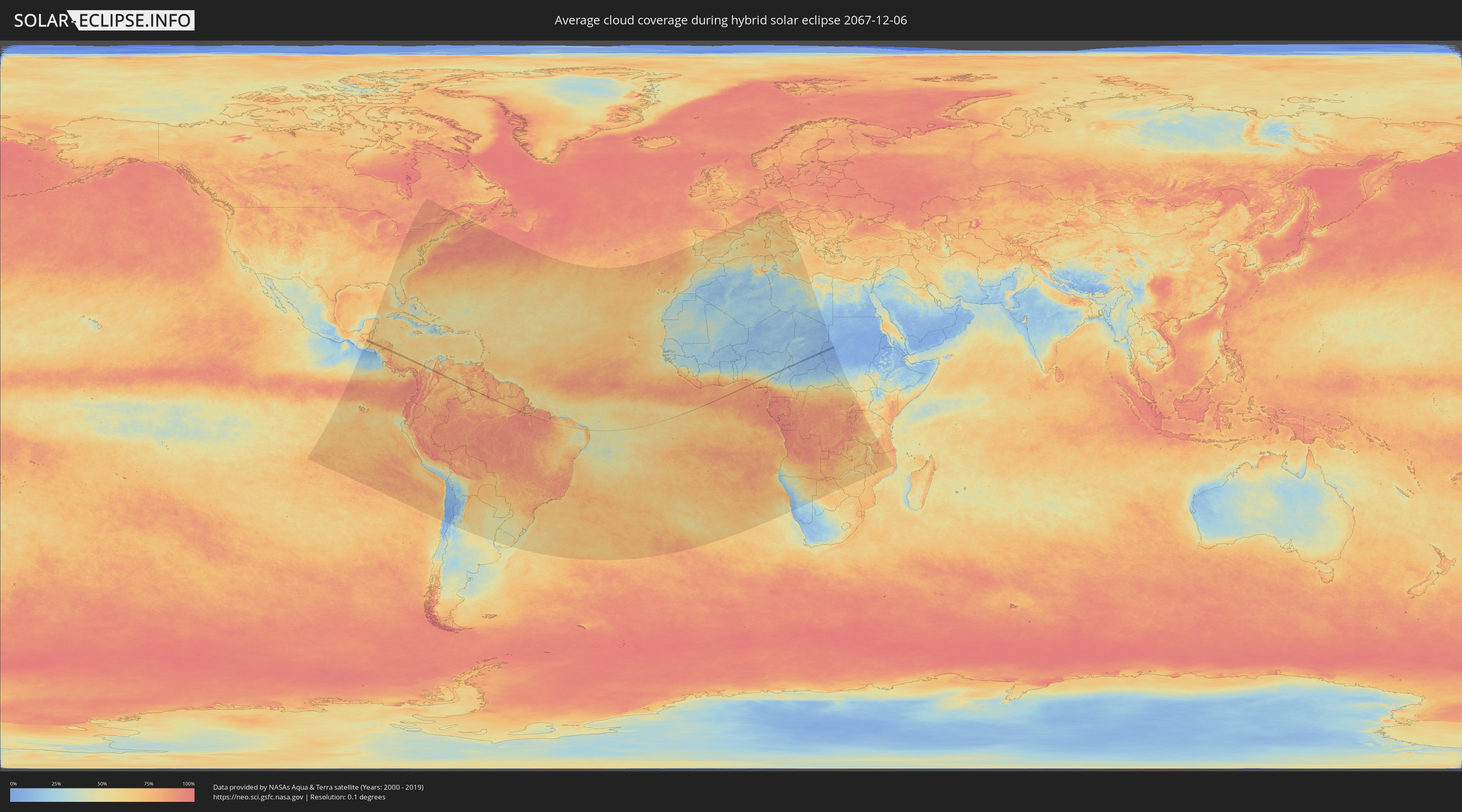
How will be the weather during the hybrid solar eclipse on 12/06/2067?
Where is the best place to see the hybrid solar eclipse of 12/06/2067?
The following maps show the average cloud coverage for the day of the hybrid solar eclipse.
With the help of these maps, it is possible to find the place along the eclipse path, which has the best
chance of a cloudless sky.
Nevertheless, you should consider local circumstances and inform about the weather of your chosen
observation site.
The data is provided by NASAs satellites
AQUA and TERRA.
The cloud maps are averaged over a period of 19 years (2000 - 2019).

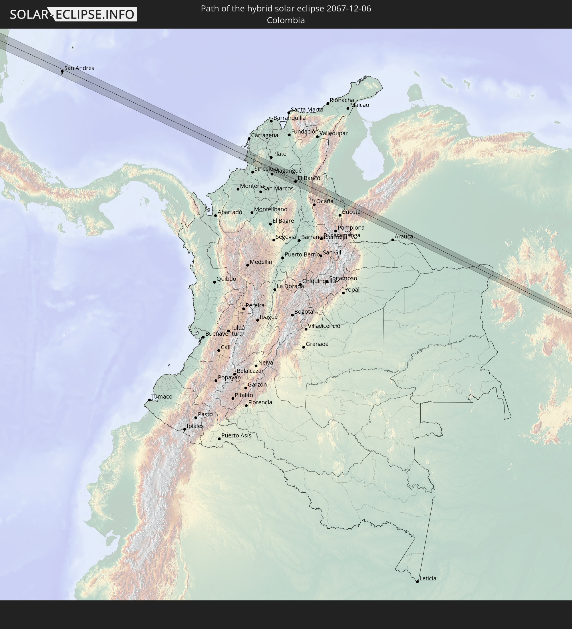
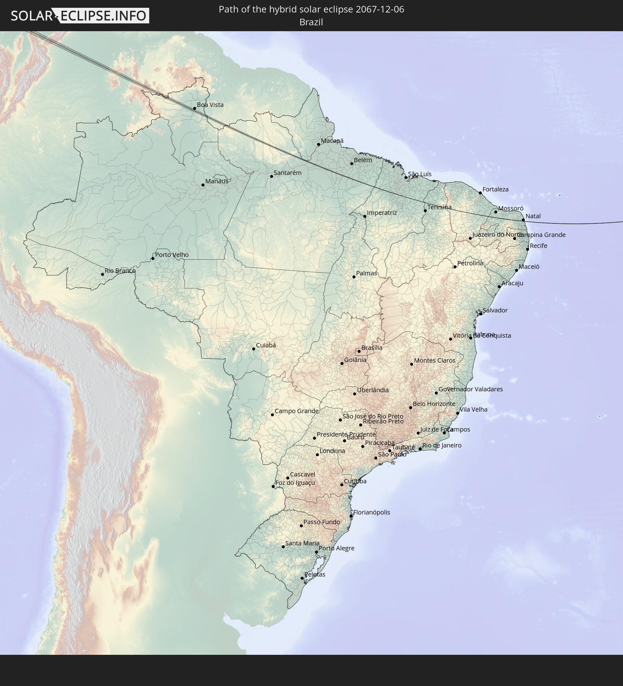
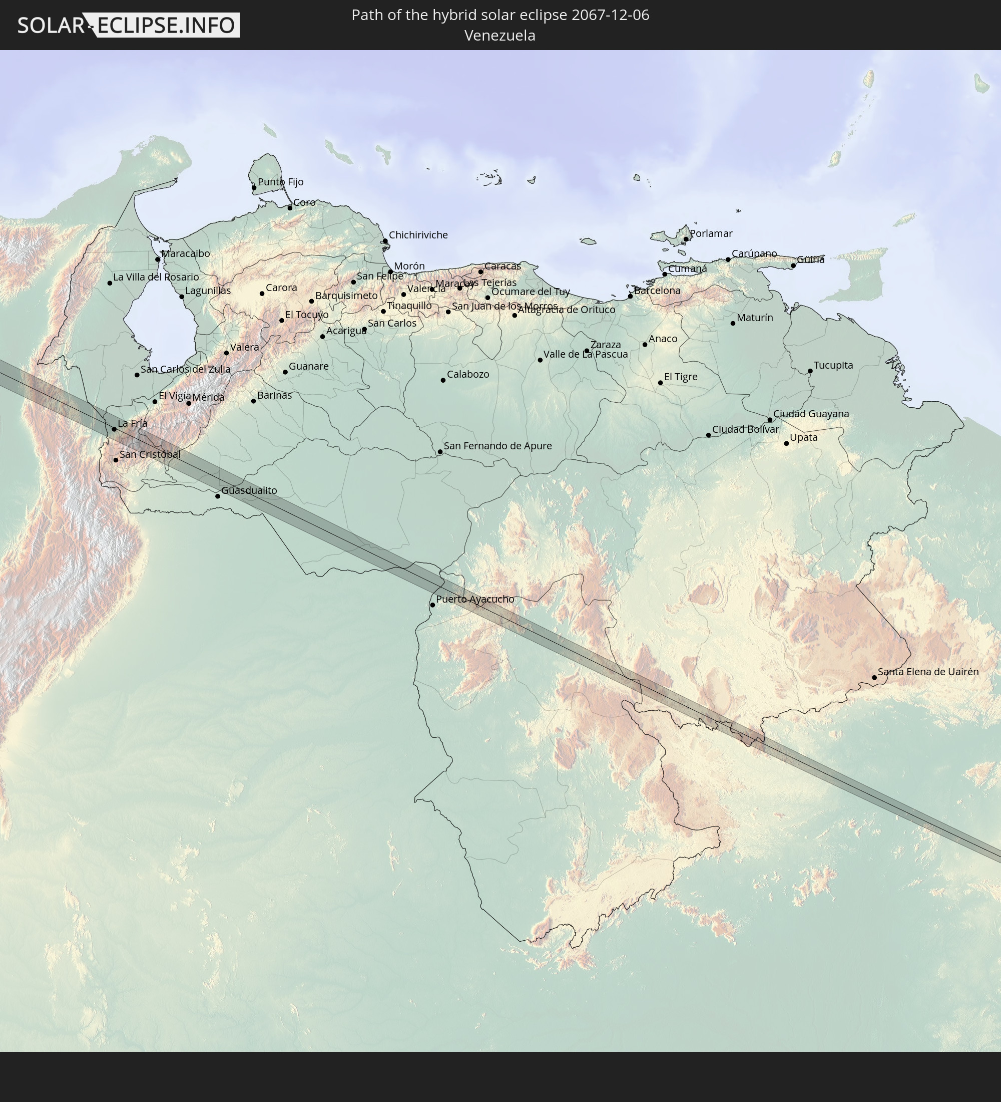
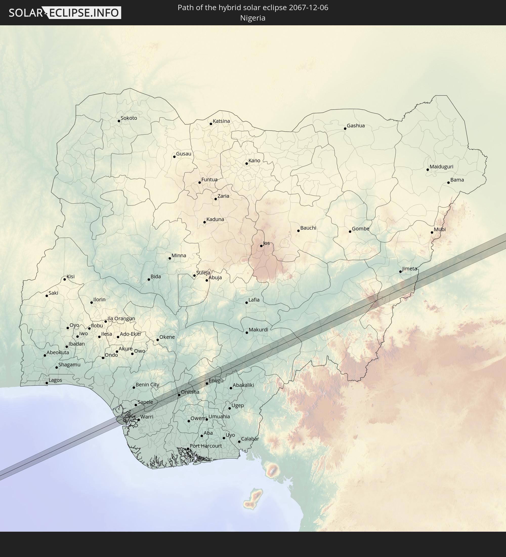
Detailed country maps
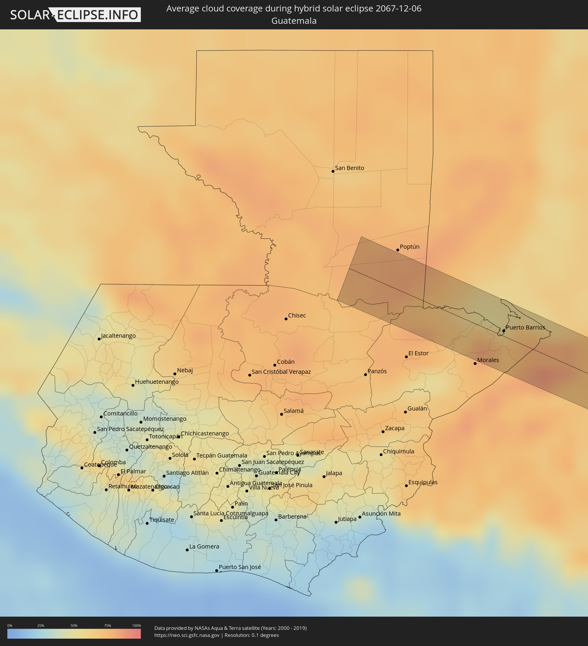 Guatemala
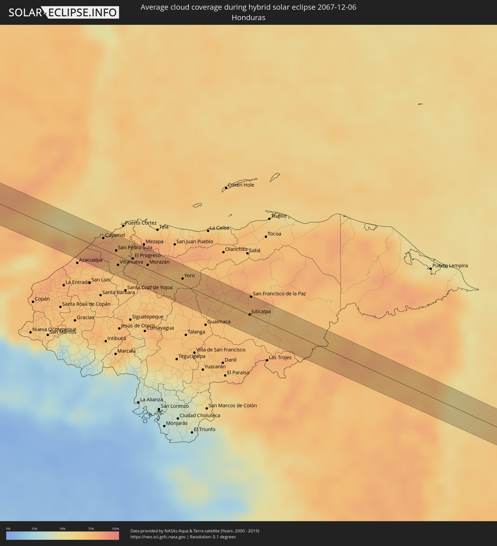 Honduras
 Belize
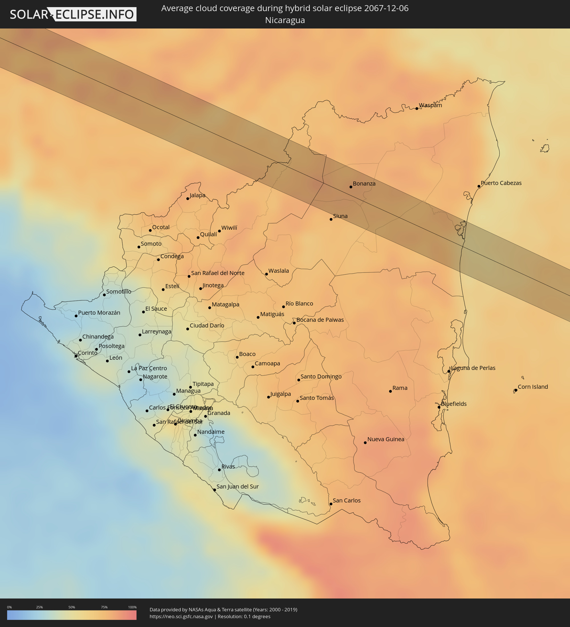 Nicaragua
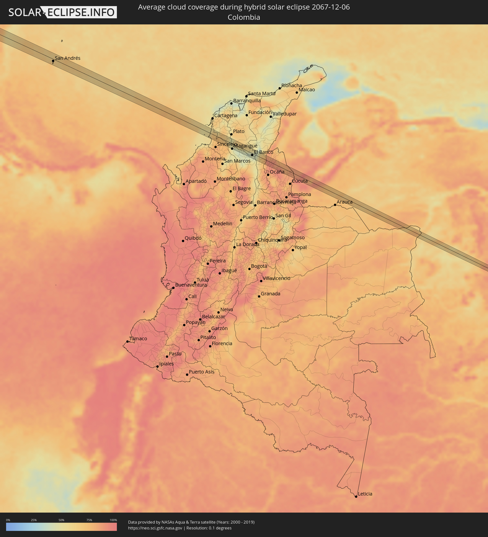 Colombia
 Brazil
 Venezuela
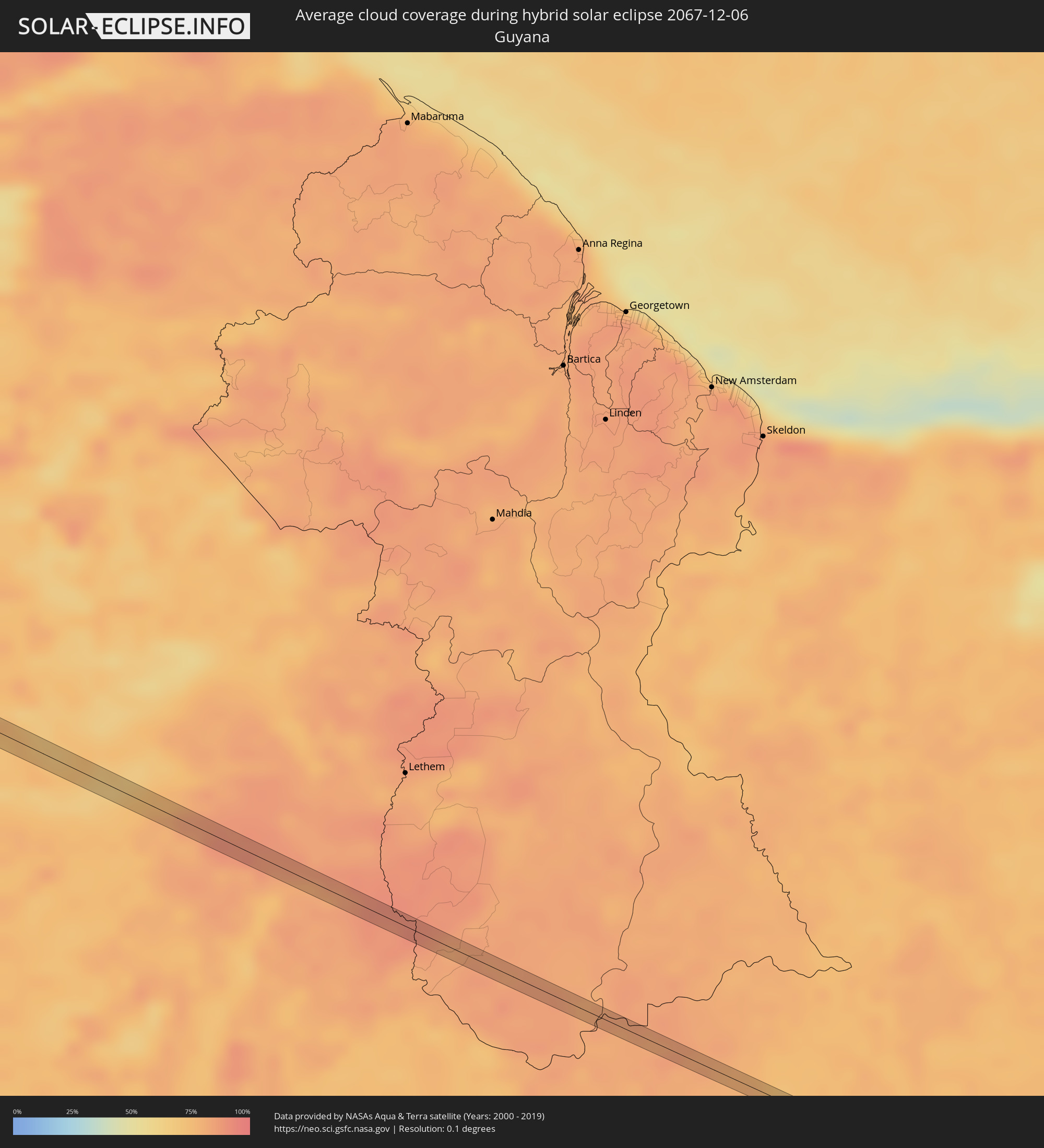 Guyana
 Nigeria
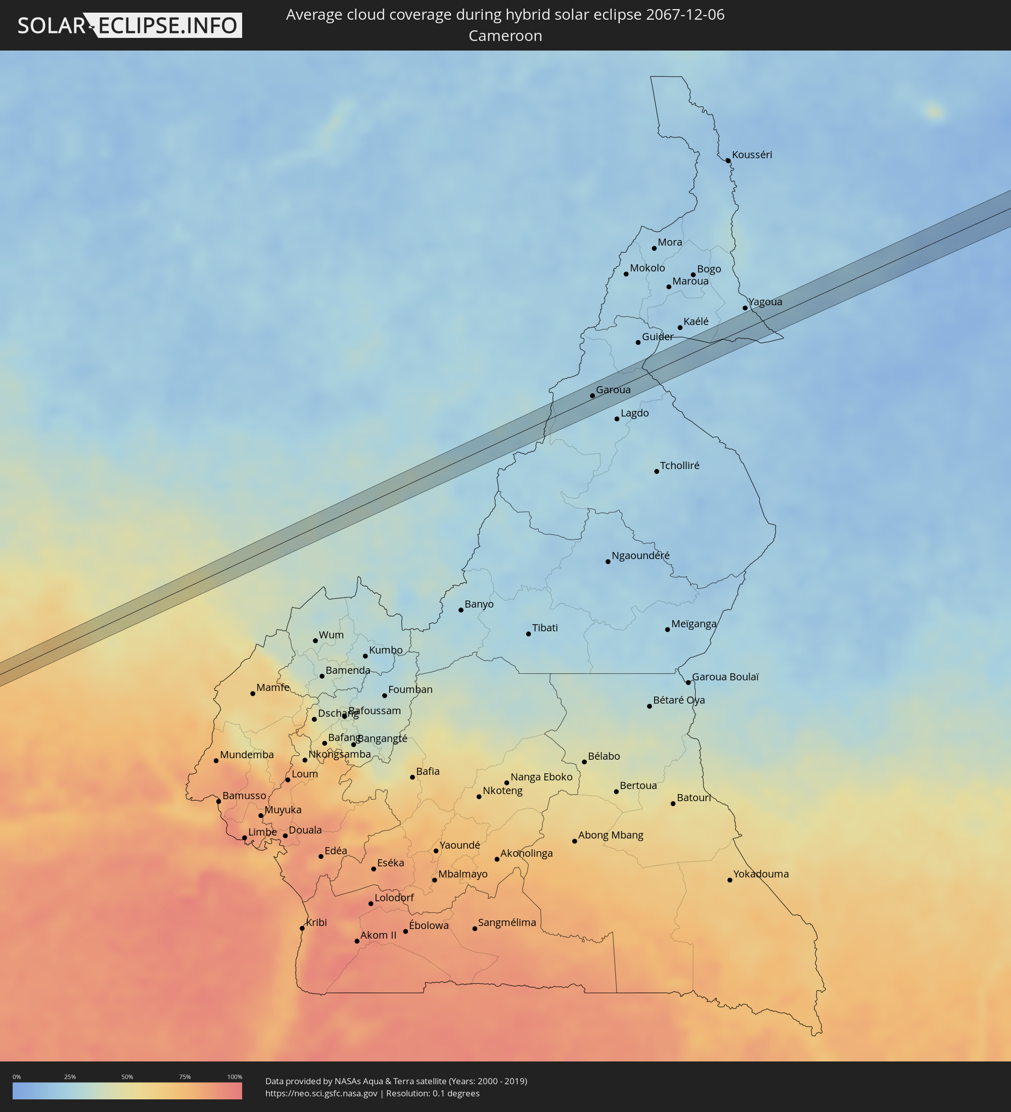 Cameroon
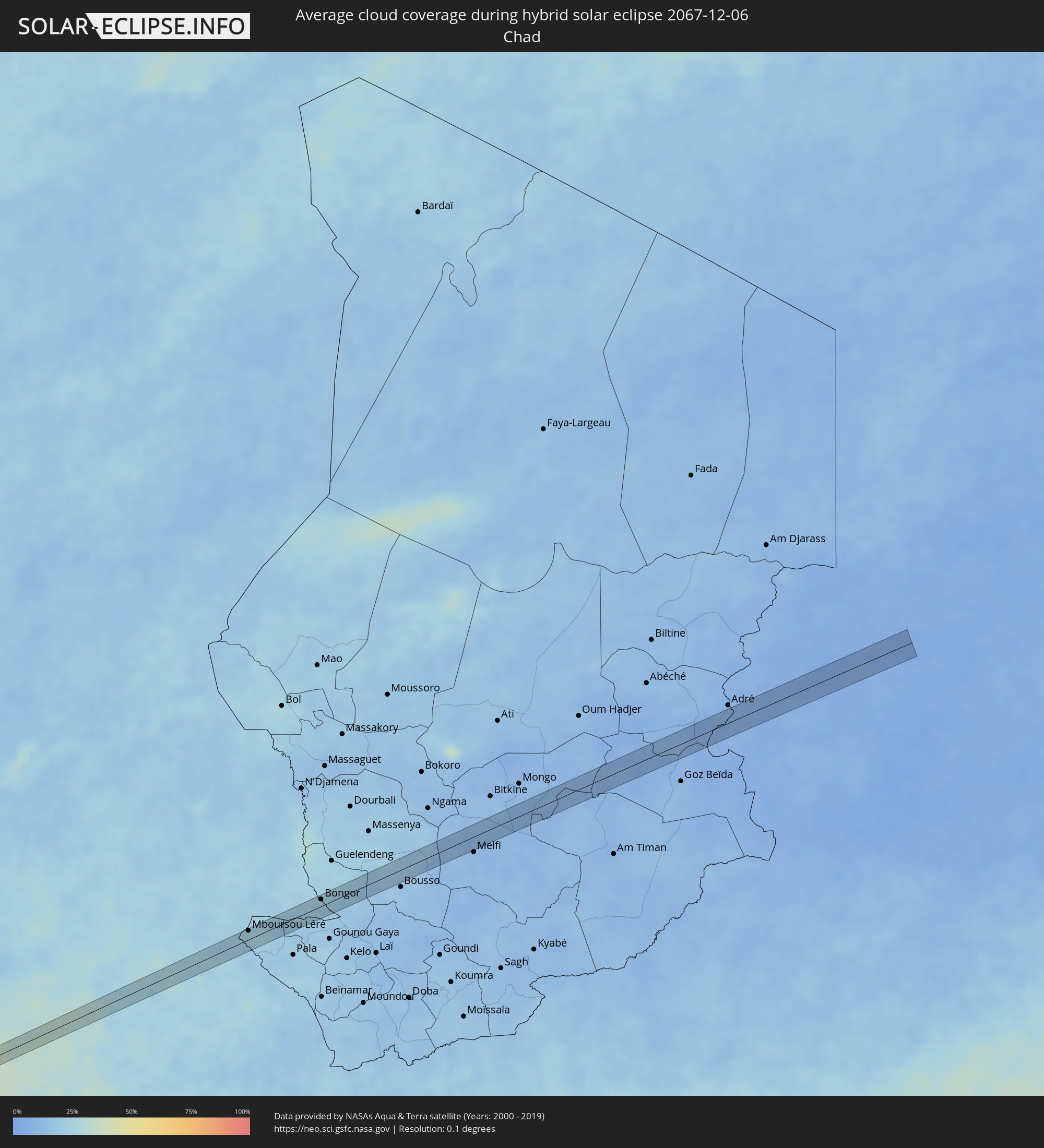 Chad
Chad
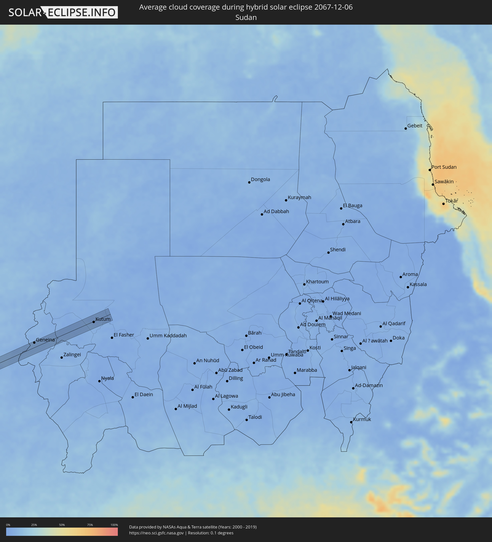 Sudan
Sudan
Cities inside the path of the eclipse
The following table shows all locations with a population of more than 5,000 inside the eclipse path. Cities which have more than 100,000 inhabitants are marked bold. A click at the locations opens a detailed map.
| City | Type | Eclipse duration | Local time of max. eclipse | Distance to central line | Ø Cloud coverage |
|
San Luis, Petén
|
annular | - | 06:17:51 UTC-06:00 | 15 km | 82% |
|
Lívingston, Izabal
|
annular | - | 06:17:51 UTC-06:00 | 7 km | 72% |
|
Puerto Barrios, Izabal
|
annular | - | 06:17:51 UTC-06:00 | 4 km | 72% |
|
Cuyamel, Cortés
|
annular | - | 06:17:54 UTC-06:00 | 15 km | 80% |
|
Cofradía, Cortés
|
annular | - | 06:17:52 UTC-06:00 | 10 km | 69% |
|
San Pedro Sula, Cortés
|
annular | - | 06:17:54 UTC-06:00 | 6 km | 74% |
|
Villanueva, Cortés
|
annular | - | 06:17:52 UTC-06:00 | 12 km | 70% |
|
Potrerillos, Cortés
|
annular | - | 06:17:51 UTC-06:00 | 19 km | 68% |
|
Pimienta Vieja, Cortés
|
annular | - | 06:17:51 UTC-06:00 | 19 km | 68% |
|
Choloma, Cortés
|
annular | - | 06:17:55 UTC-06:00 | 20 km | 75% |
|
San Manuel, Cortés
|
annular | - | 06:17:53 UTC-06:00 | 7 km | 71% |
|
La Lima, Cortés
|
annular | - | 06:17:54 UTC-06:00 | 3 km | 71% |
|
Agua Blanca Sur, Yoro
|
annular | - | 06:17:52 UTC-06:00 | 14 km | 71% |
|
El Progreso, Yoro
|
annular | - | 06:17:55 UTC-06:00 | 5 km | 76% |
|
El Negrito, Yoro
|
annular | - | 06:17:55 UTC-06:00 | 1 km | 72% |
|
Morazán, Yoro
|
annular | - | 06:17:56 UTC-06:00 | 5 km | 74% |
|
Santa Rita, Yoro
|
annular | - | 06:17:57 UTC-06:00 | 4 km | 72% |
|
Yoro, Yoro
|
annular | - | 06:17:58 UTC-06:00 | 8 km | 80% |
|
Juticalpa, Olancho
|
annular | - | 06:18:05 UTC-06:00 | 0 km | 69% |
|
San Francisco de la Paz, Olancho
|
annular | - | 06:18:07 UTC-06:00 | 25 km | 73% |
|
Bonanza, Atlántico Norte (RAAN)
|
annular | - | 06:18:23 UTC-06:00 | 8 km | 78% |
|
San Andrés, Archipiélago de San Andrés, Providencia y Santa Catalina
|
annular | - | 07:19:11 UTC-05:00 | 8 km | 66% |
|
San Onofre, Sucre
|
annular | - | 07:22:22 UTC-05:00 | 7 km | 69% |
|
Ovejas, Sucre
|
annular | - | 07:22:35 UTC-05:00 | 13 km | 74% |
|
El Carmen de Bolívar, Bolívar
|
annular | - | 07:22:38 UTC-05:00 | 11 km | 68% |
|
San Pedro, Sucre
|
annular | - | 07:22:42 UTC-05:00 | 19 km | 75% |
|
Córdoba, Bolívar
|
annular | - | 07:22:51 UTC-05:00 | 11 km | 49% |
|
Cicuco, Bolívar
|
annular | - | 07:23:00 UTC-05:00 | 13 km | 45% |
|
Talaigua Viejo, Bolívar
|
annular | - | 07:23:03 UTC-05:00 | 5 km | 41% |
|
Santa Ana, Magdalena
|
annular | - | 07:23:03 UTC-05:00 | 3 km | 41% |
|
San Zenón, Bolívar
|
annular | - | 07:23:07 UTC-05:00 | 7 km | 40% |
|
Pijiño, Magdalena
|
annular | - | 07:23:08 UTC-05:00 | 4 km | 40% |
|
Mompós, Bolívar
|
annular | - | 07:23:10 UTC-05:00 | 4 km | 41% |
|
Guamal, Magdalena
|
annular | - | 07:23:19 UTC-05:00 | 4 km | 42% |
|
Barranco de Loba, Bolívar
|
annular | - | 07:23:26 UTC-05:00 | 18 km | 53% |
|
El Banco, Magdalena
|
annular | - | 07:23:31 UTC-05:00 | 7 km | 43% |
|
Pailitas, Cesar
|
annular | - | 07:23:47 UTC-05:00 | 6 km | 71% |
|
Tibú, Norte de Santander
|
annular | - | 07:24:30 UTC-05:00 | 16 km | 79% |
|
Puerto Santander, Norte de Santander
|
annular | - | 07:24:49 UTC-05:00 | 5 km | 84% |
|
La Fría, Táchira
|
annular | - | 08:24:58 UTC-04:00 | 3 km | 91% |
|
Gurupá, Pará
|
annular | - | 09:59:55 UTC-03:00 | 2 km | 85% |
|
Cametá, Pará
|
annular | - | 10:05:36 UTC-03:00 | 1 km | 76% |
|
Paragominas, Pará
|
annular | - | 10:11:18 UTC-03:00 | 1 km | 92% |
|
Macaíba, Rio Grande do Norte
|
total | - | 10:51:01 UTC-03:00 | 1 km | 74% |
|
Abraka, Delta
|
annular | - | 16:36:31 UTC+01:00 | 12 km | 77% |
|
Obiaruku, Delta
|
annular | - | 16:36:34 UTC+01:00 | 9 km | 73% |
|
Ogwashi-Uku, Delta
|
annular | - | 16:36:58 UTC+01:00 | 7 km | 68% |
|
Asaba, Delta
|
annular | - | 16:37:09 UTC+01:00 | 1 km | 67% |
|
Onitsha, Anambra
|
annular | - | 16:37:11 UTC+01:00 | 8 km | 64% |
|
Nkpor, Anambra
|
annular | - | 16:37:14 UTC+01:00 | 10 km | 64% |
|
Enugu, Enugu
|
annular | - | 16:37:51 UTC+01:00 | 12 km | 52% |
|
Ikem, Enugu
|
annular | - | 16:38:05 UTC+01:00 | 12 km | 49% |
|
Eha Amufu, Enugu
|
annular | - | 16:38:06 UTC+01:00 | 2 km | 48% |
|
Yandev, Benue
|
annular | - | 16:39:13 UTC+01:00 | 9 km | 38% |
|
Zaki Biam, Benue
|
annular | - | 16:39:39 UTC+01:00 | 3 km | 34% |
|
Garoua, North
|
annular | - | 16:42:10 UTC+01:00 | 3 km | 23% |
|
Pitoa, North
|
annular | - | 16:42:14 UTC+01:00 | 6 km | 24% |
|
Mboursou Léré, Mayo-Kebbi Ouest
|
annular | - | 16:42:34 UTC+01:00 | 15 km | 24% |
|
Bongor, Mayo-Kebbi Est
|
annular | - | 16:43:09 UTC+01:00 | 11 km | 20% |
|
Geneina, Western Darfur
|
annular | - | 17:45:04 UTC+02:00 | 17 km | 7% |
|
Kutum, Northern Darfur
|
annular | - | 17:45:15 UTC+02:00 | 3 km | 5% |