Total solar eclipse of 06/03/2114
| Day of week: | Sunday |
| Maximum duration of eclipse: | 06m32s |
| Maximum width of eclipse path: | 248 km |
| Saros cycle: | 139 |
| Coverage: | 100% |
| Magnitude: | 1.0766 |
| Gamma: | 0.0525 |
Wo kann man die Sonnenfinsternis vom 06/03/2114 sehen?
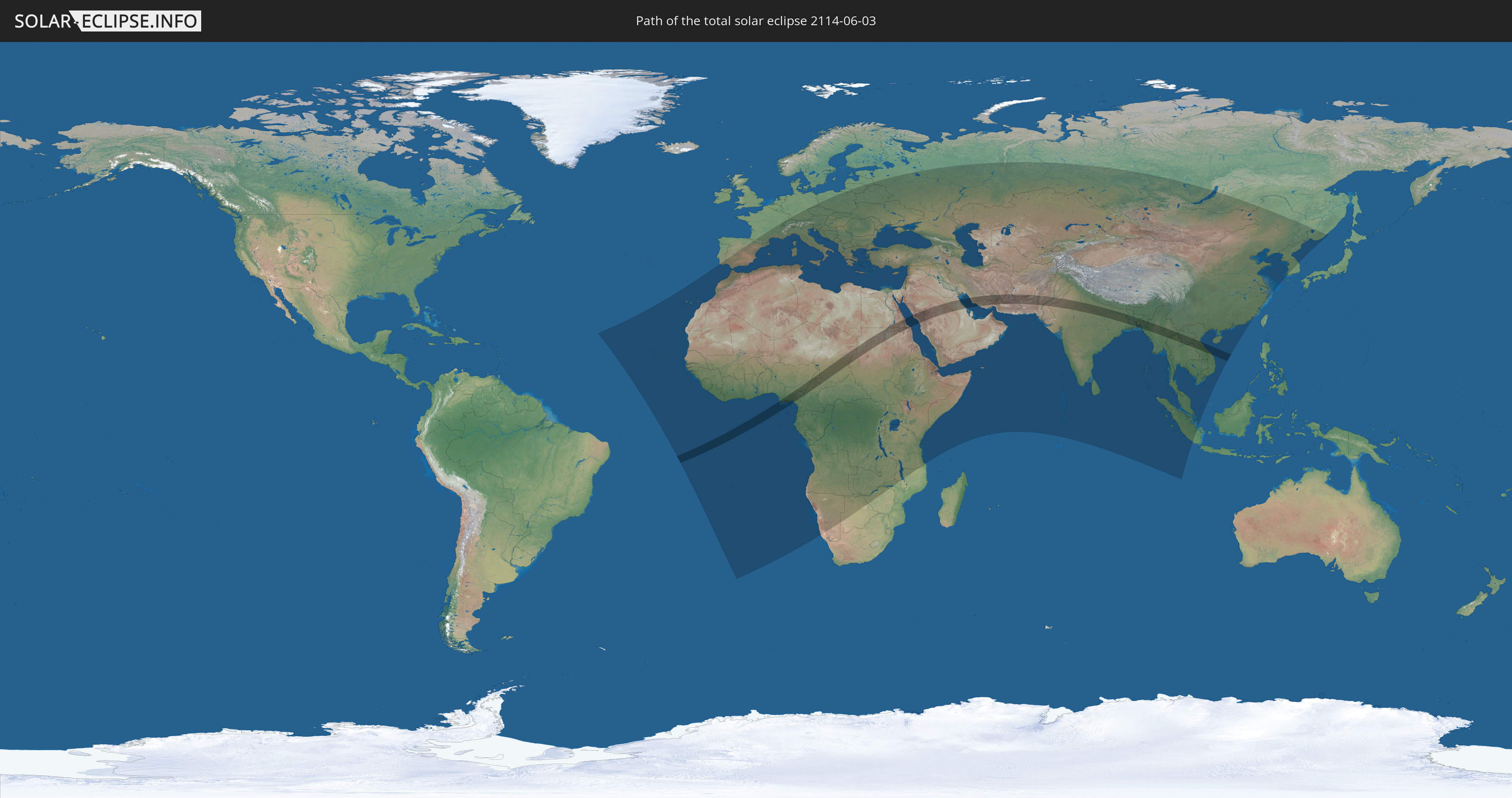
Die Sonnenfinsternis am 06/03/2114 kann man in 129 Ländern als partielle Sonnenfinsternis beobachten.
Der Finsternispfad verläuft durch 17 Länder. Nur in diesen Ländern ist sie als total Sonnenfinsternis zu sehen.
In den folgenden Ländern ist die Sonnenfinsternis total zu sehen
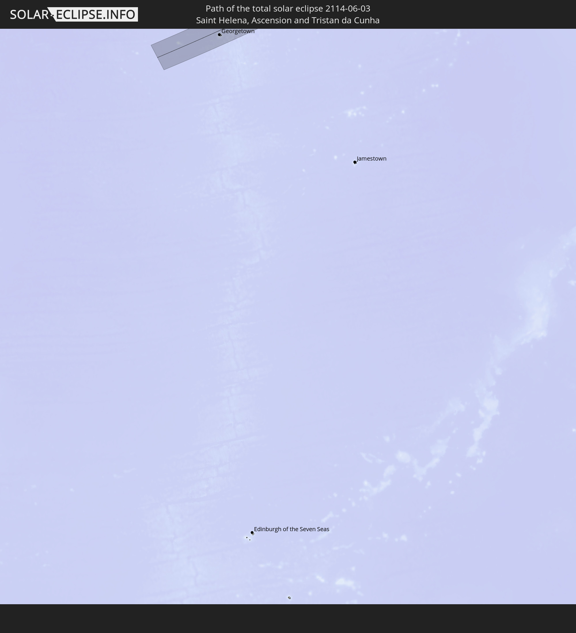 Saint Helena, Ascension and Tristan da Cunha
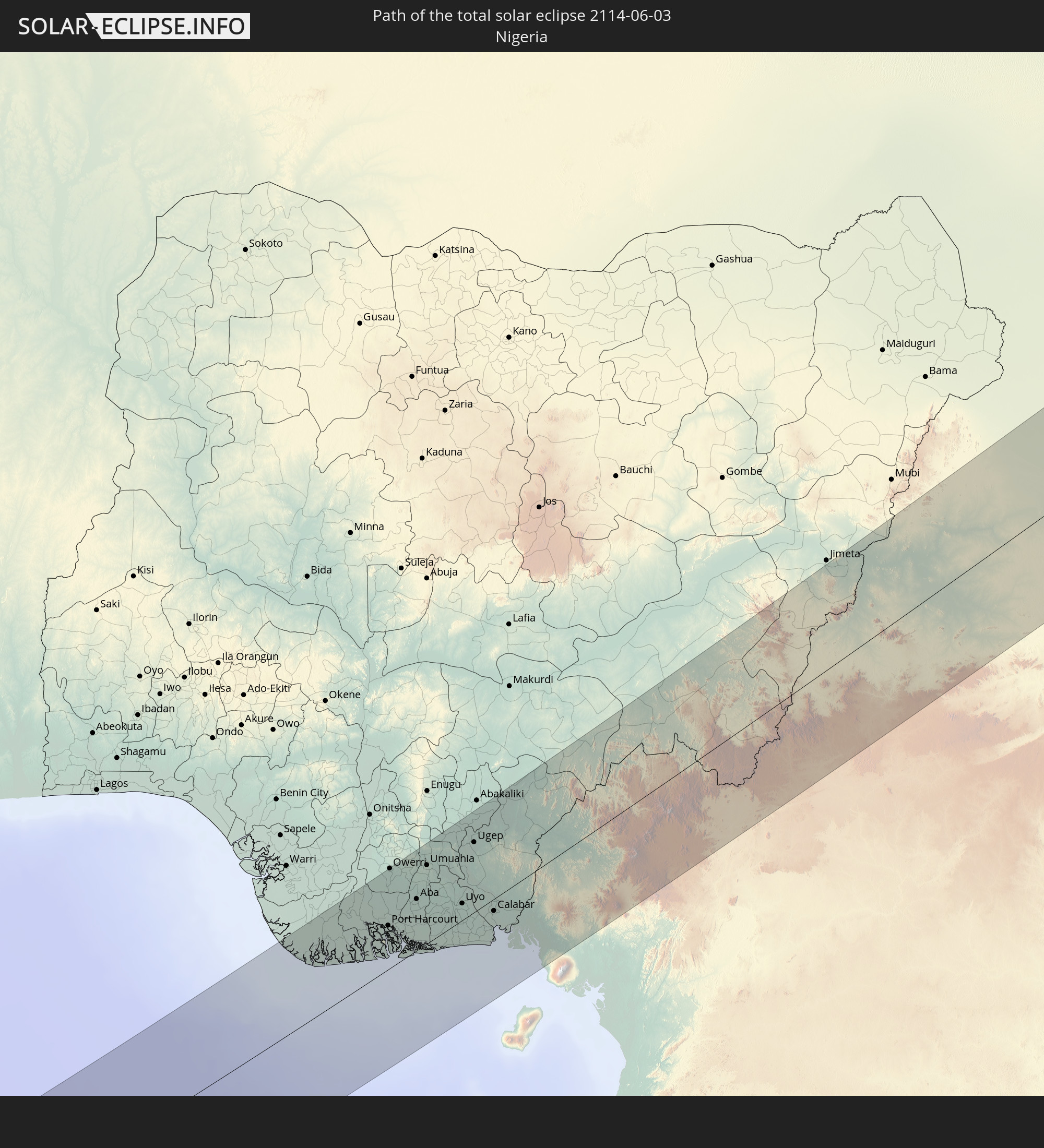 Nigeria
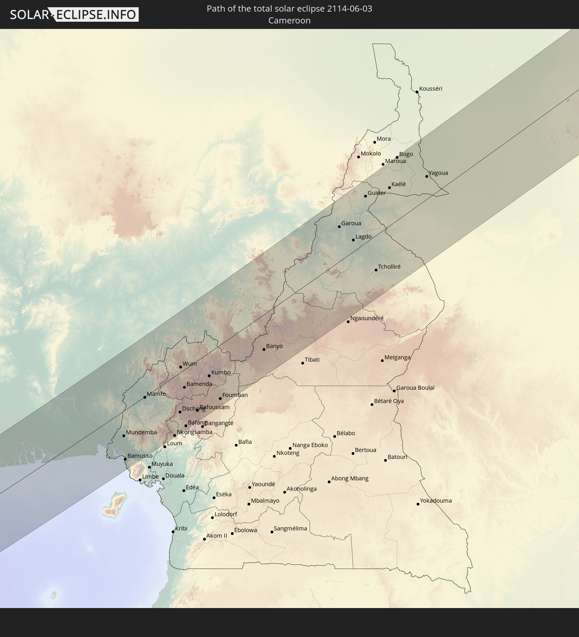 Cameroon
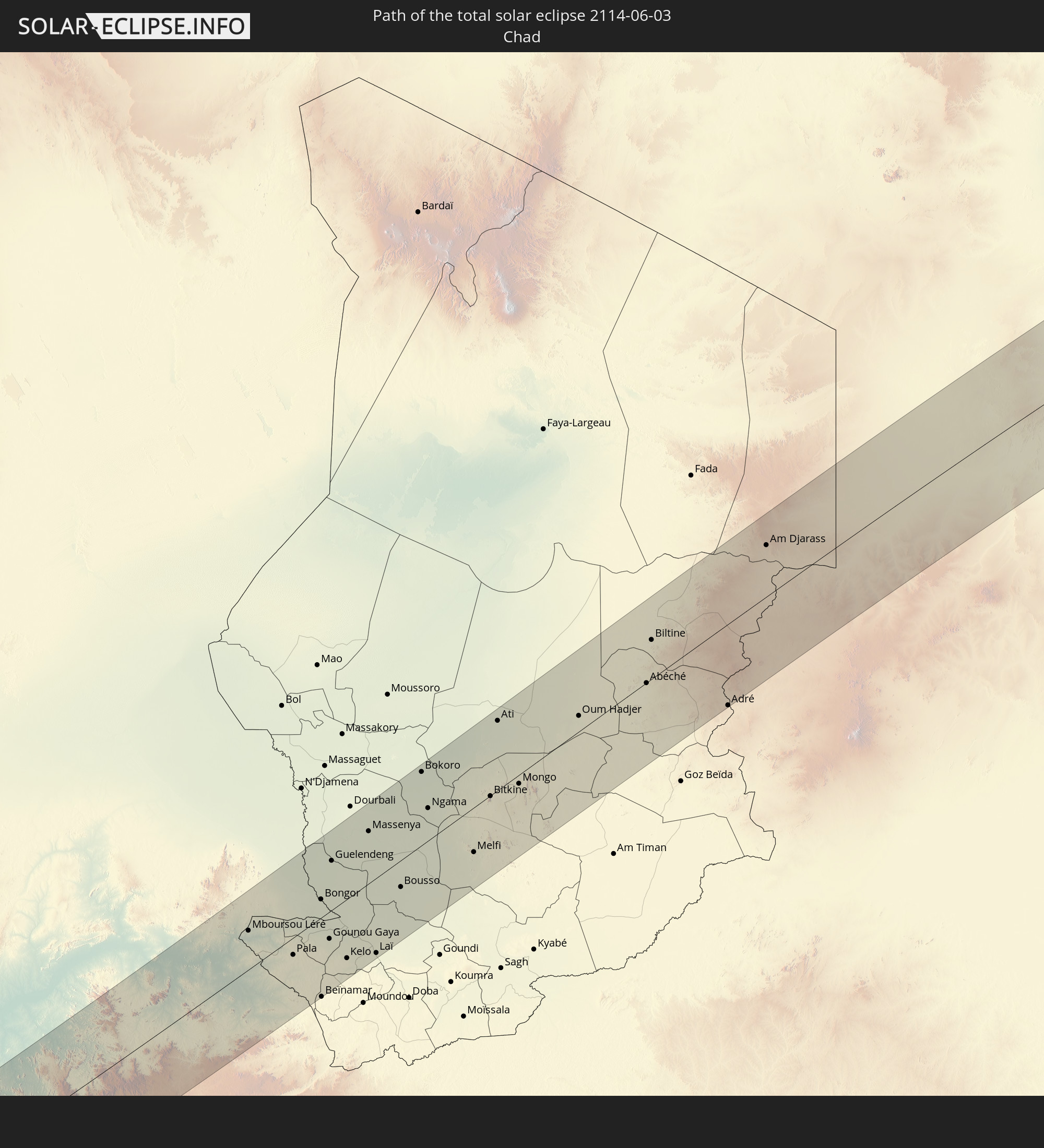 Chad
Chad
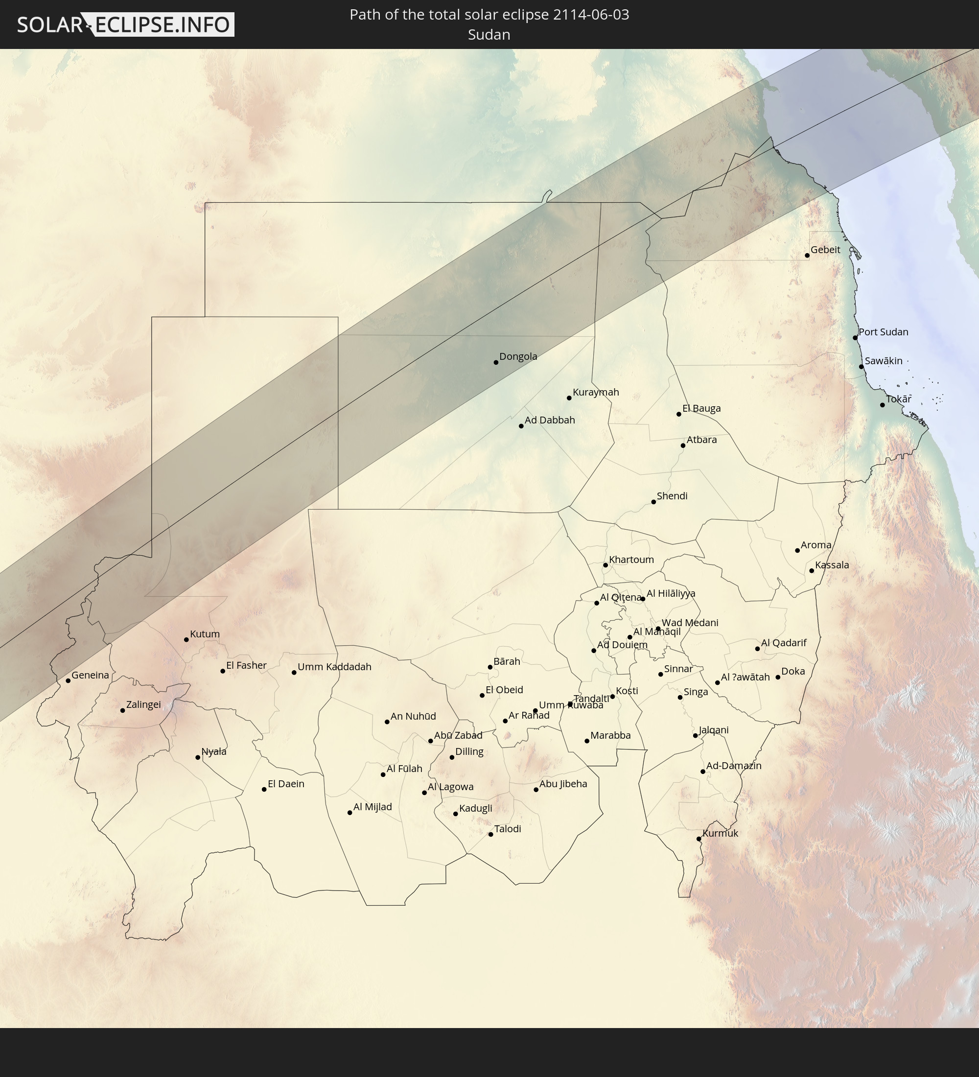 Sudan
Sudan
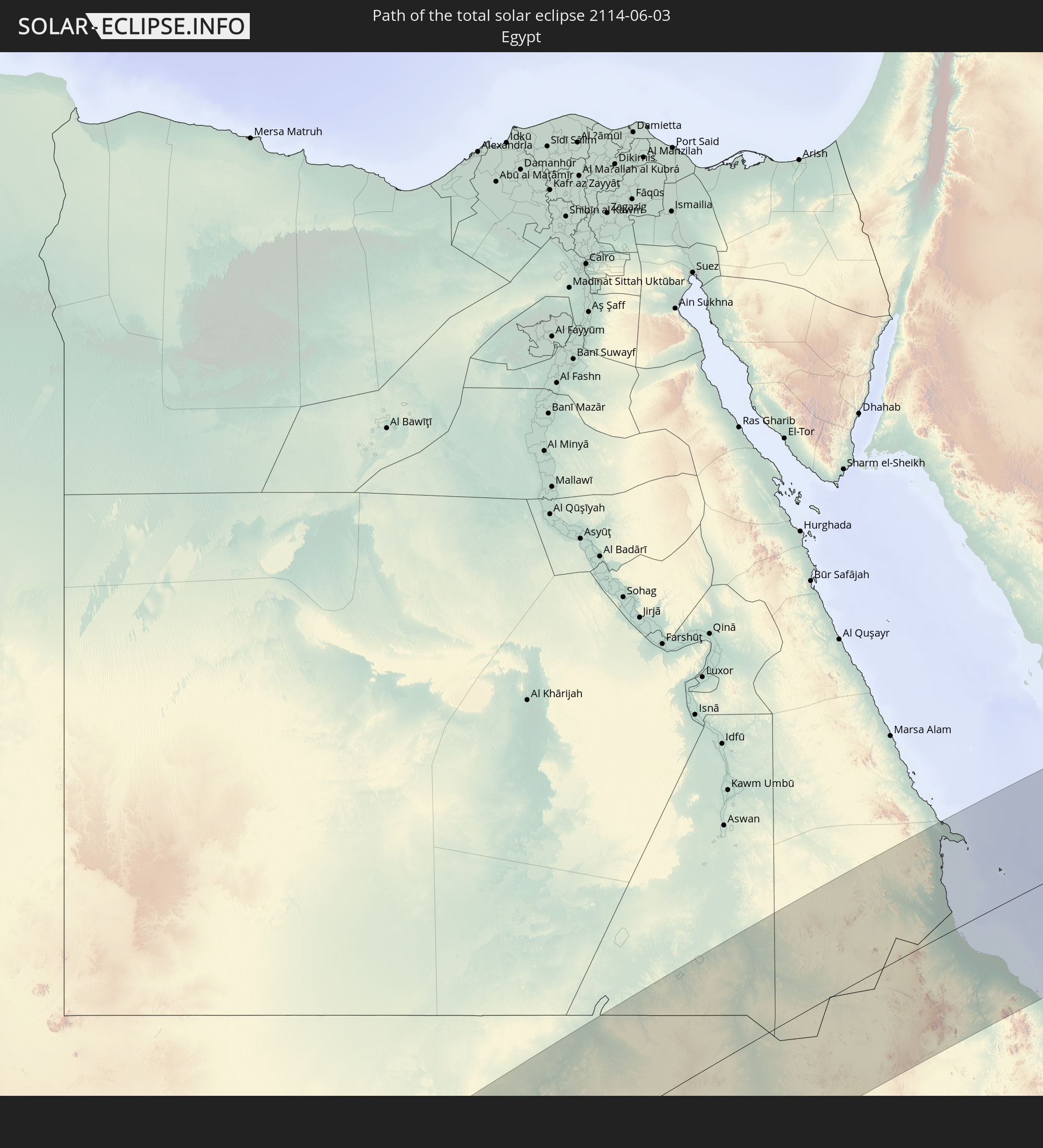 Egypt
Egypt
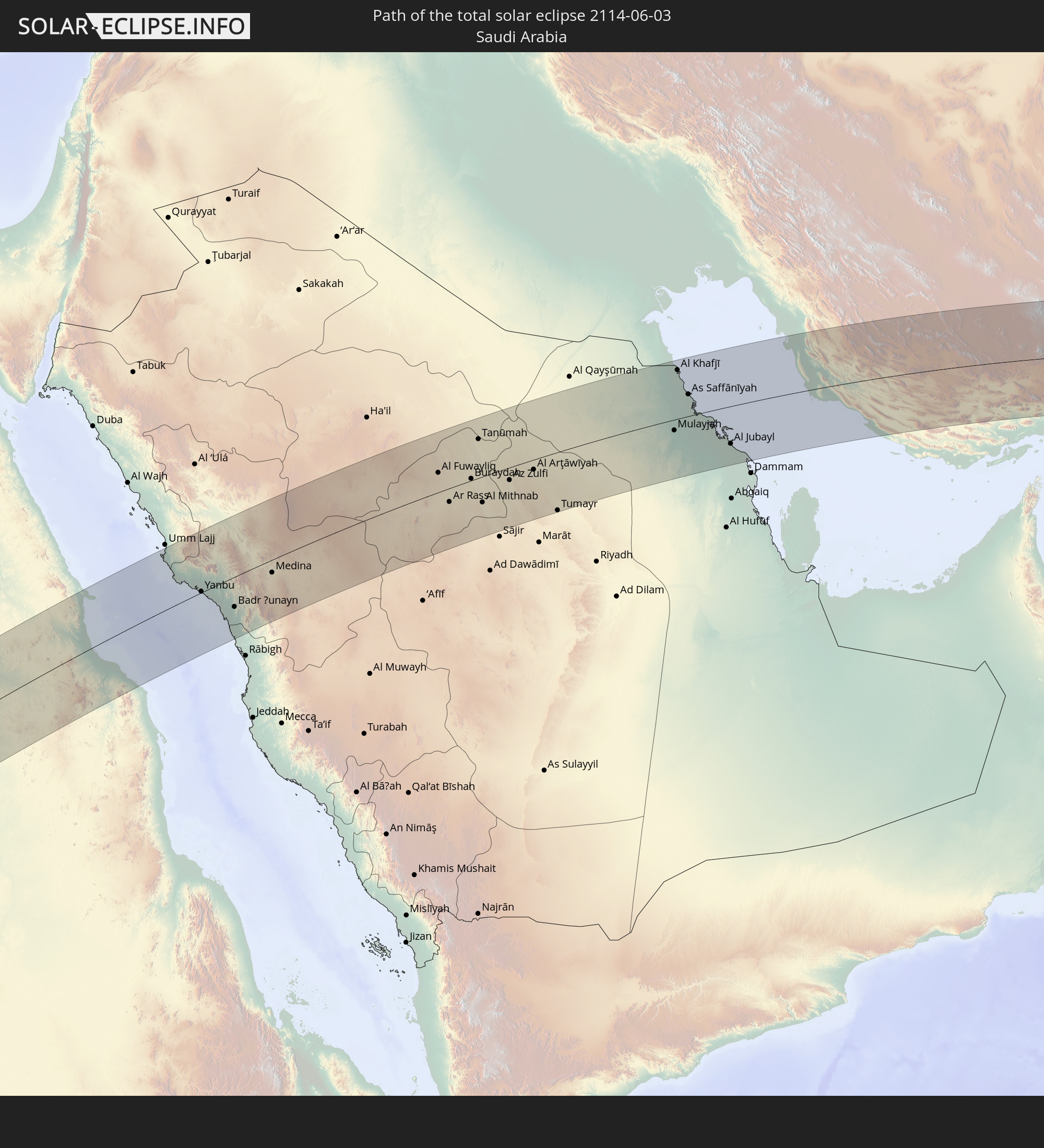 Saudi Arabia
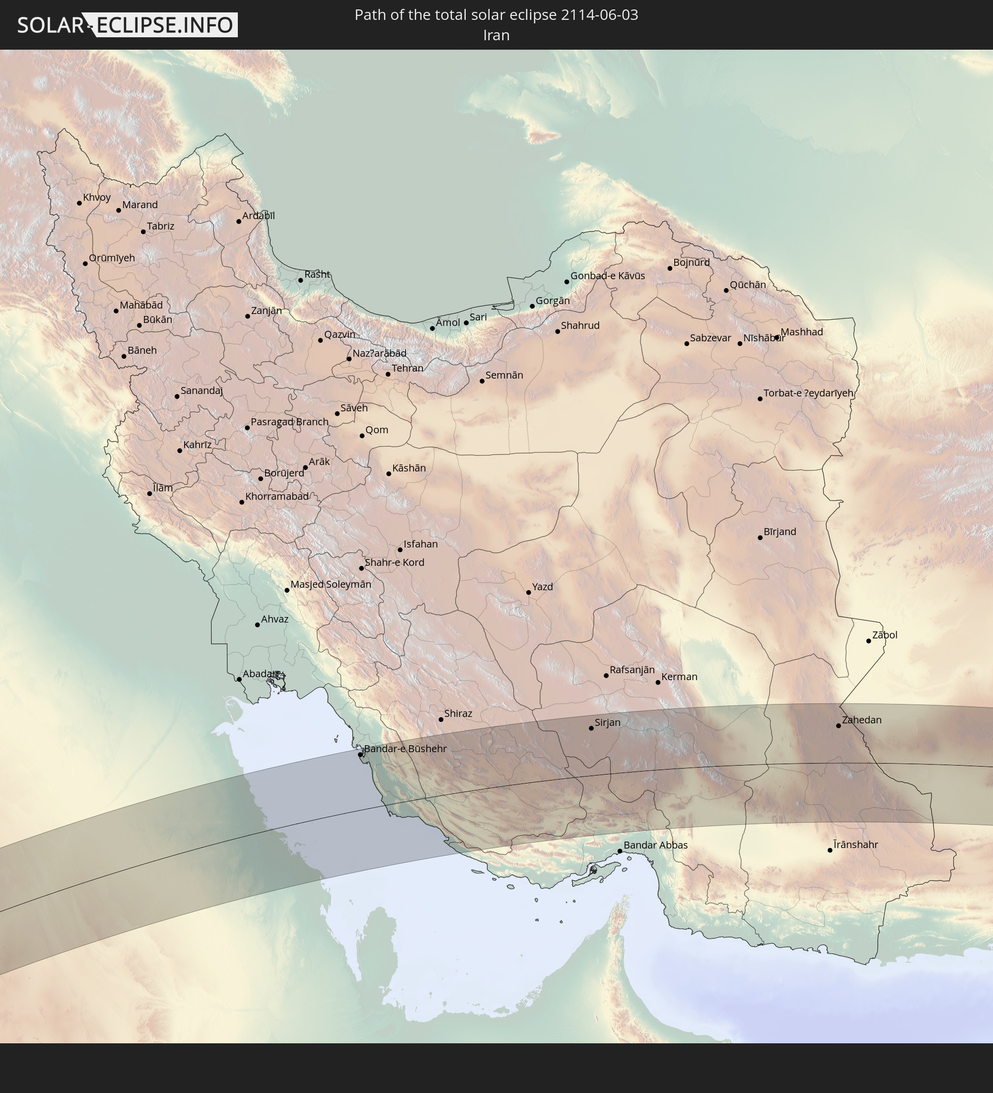 Iran
Iran
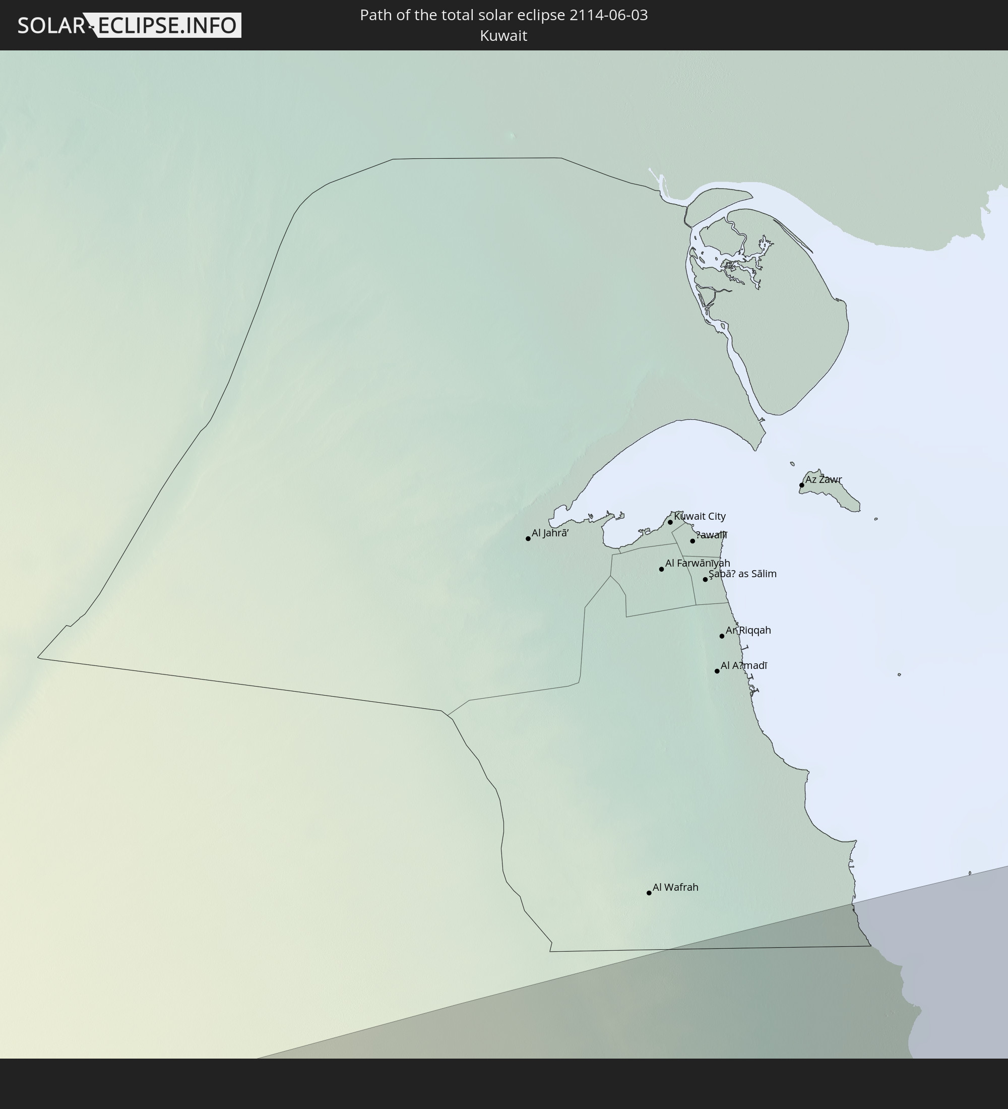 Kuwait
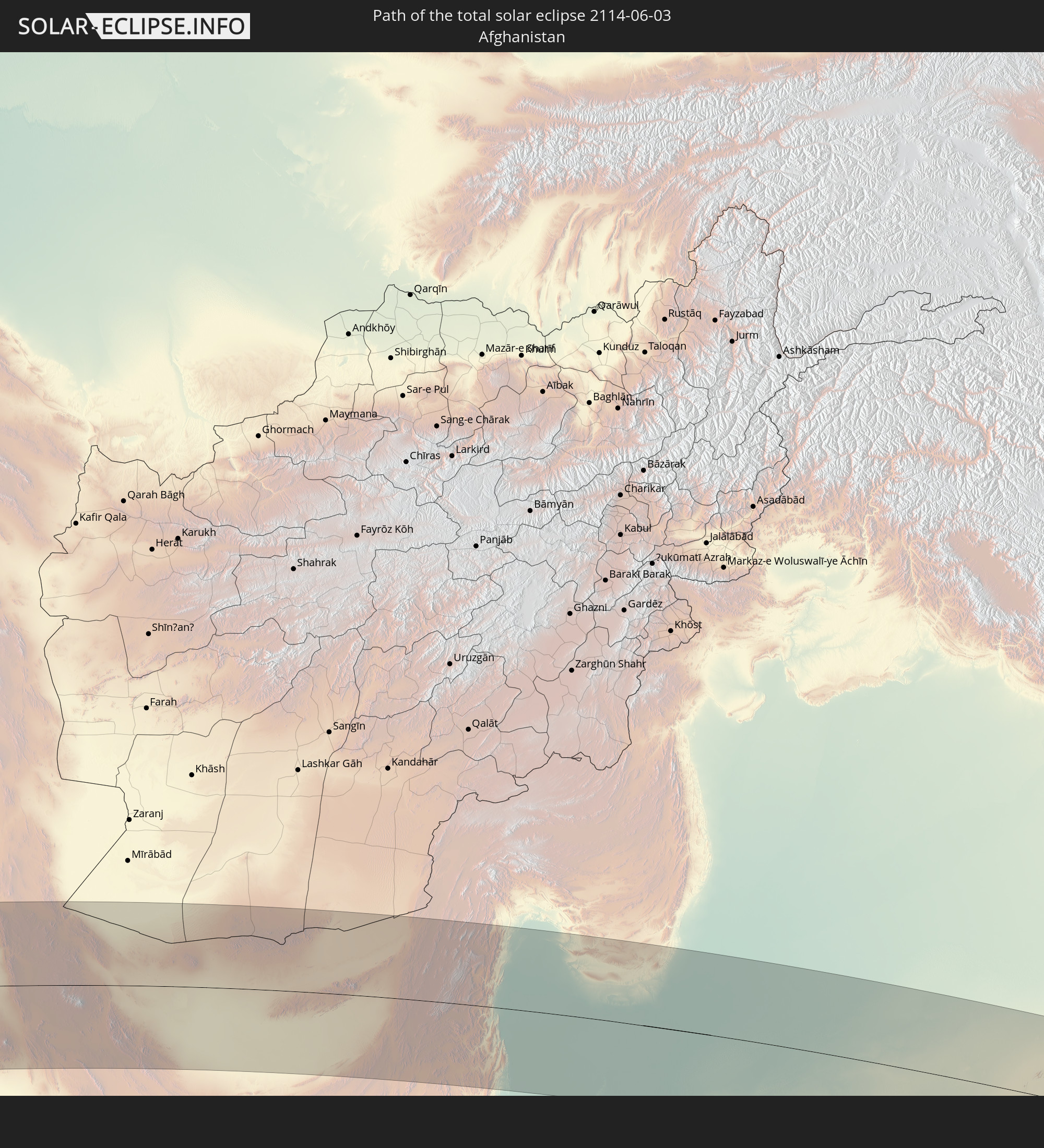 Afghanistan
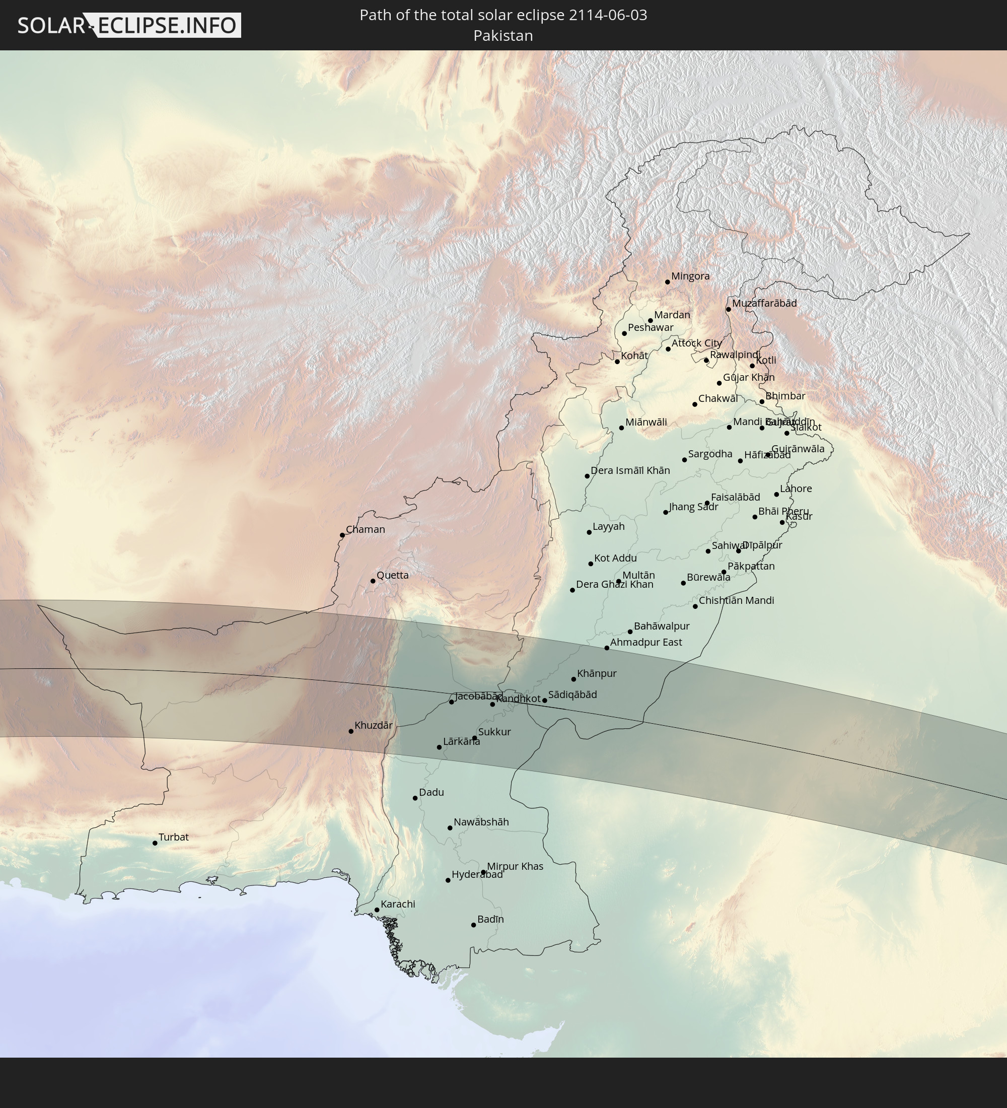 Pakistan
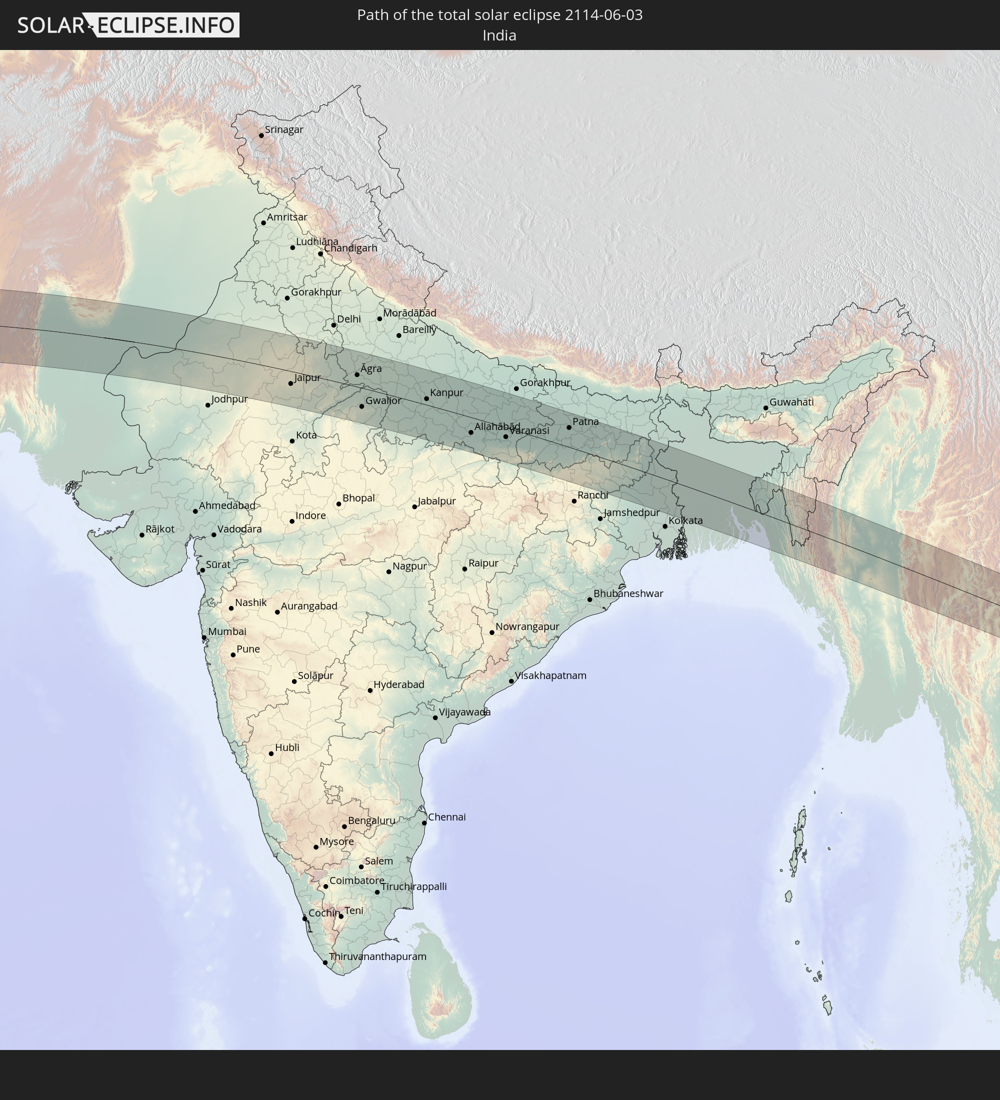 India
India
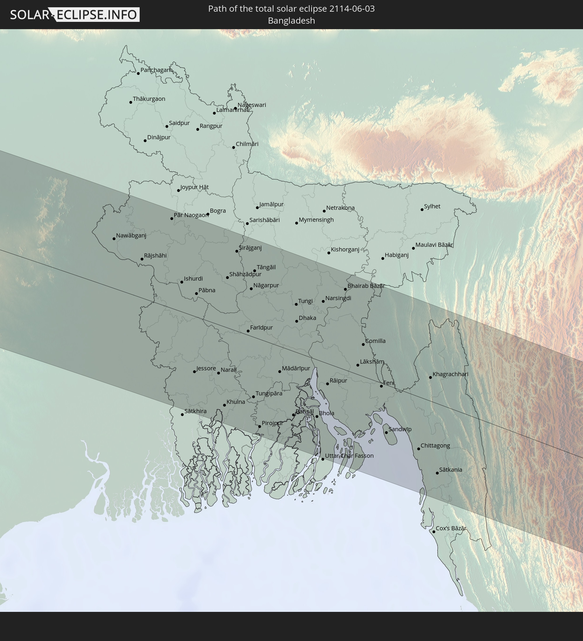 Bangladesh
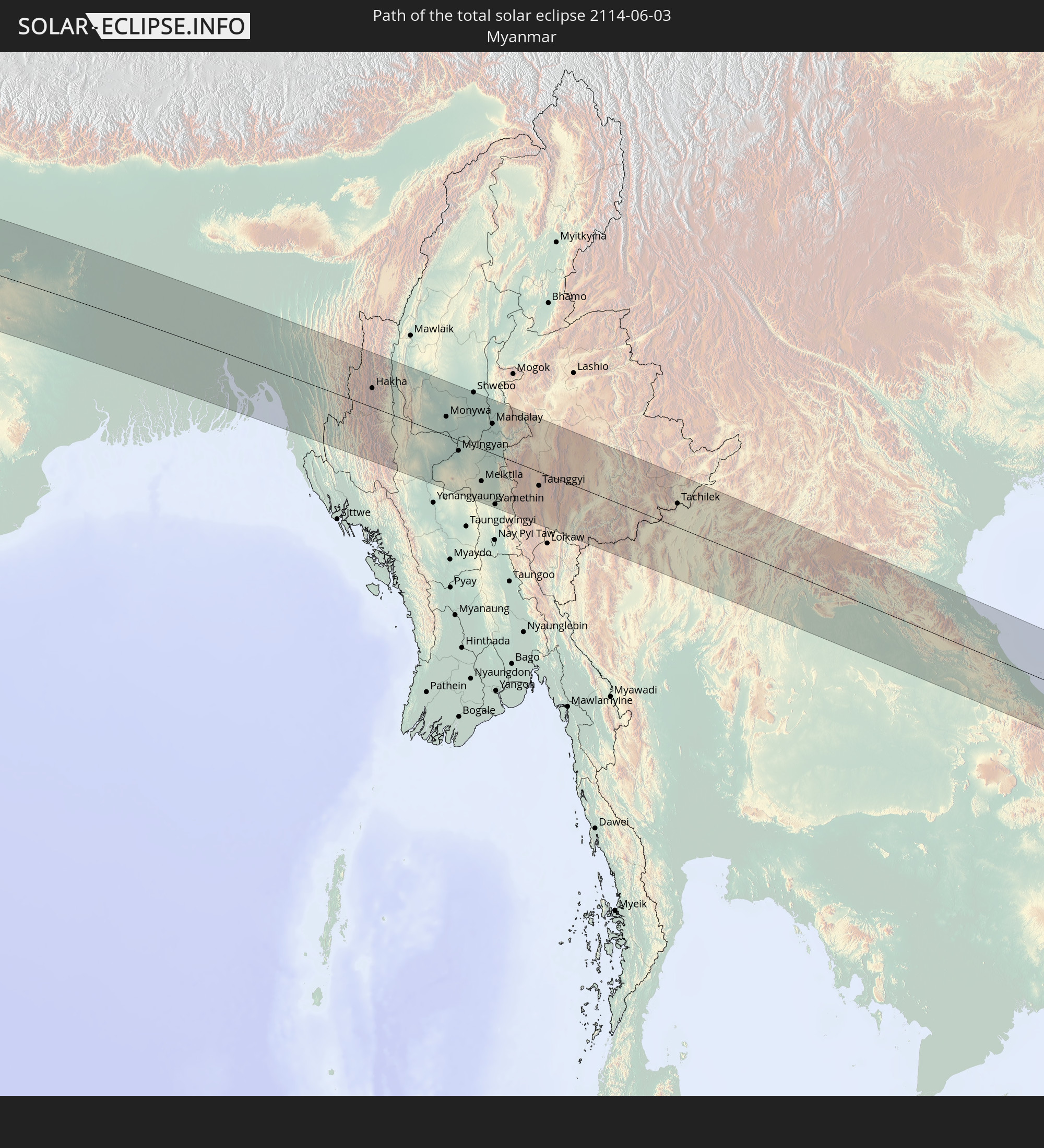 Myanmar
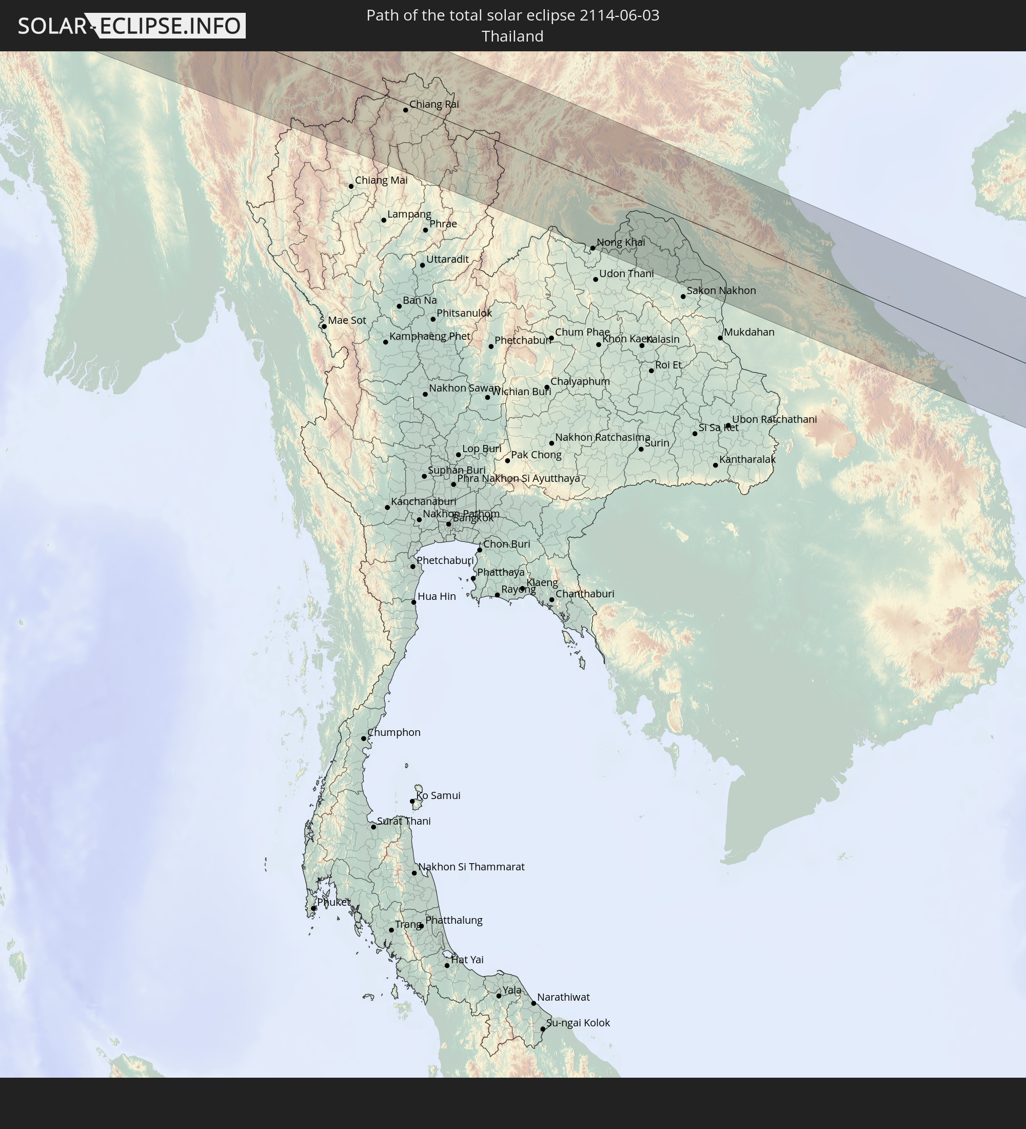 Thailand
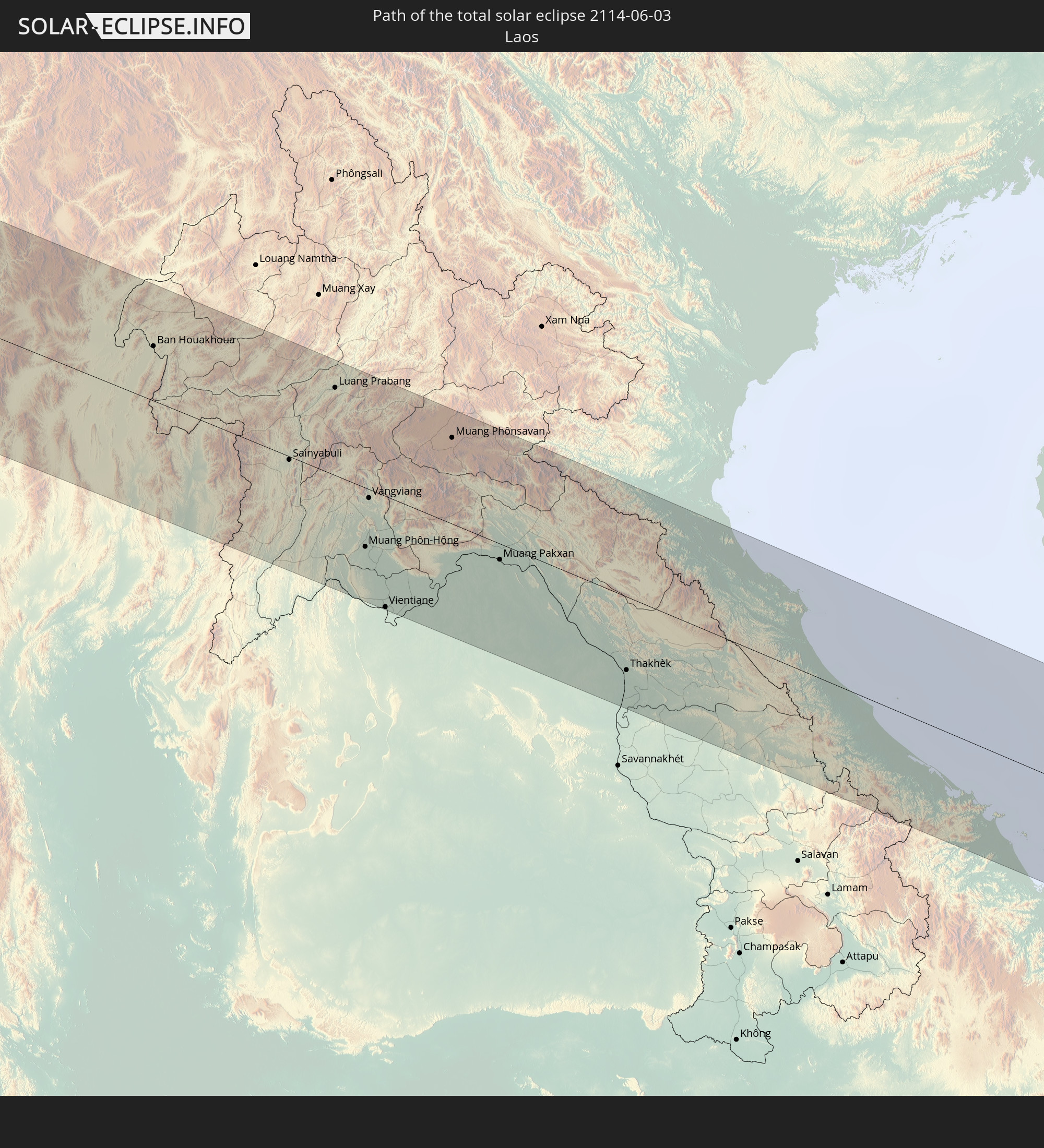 Laos
Laos
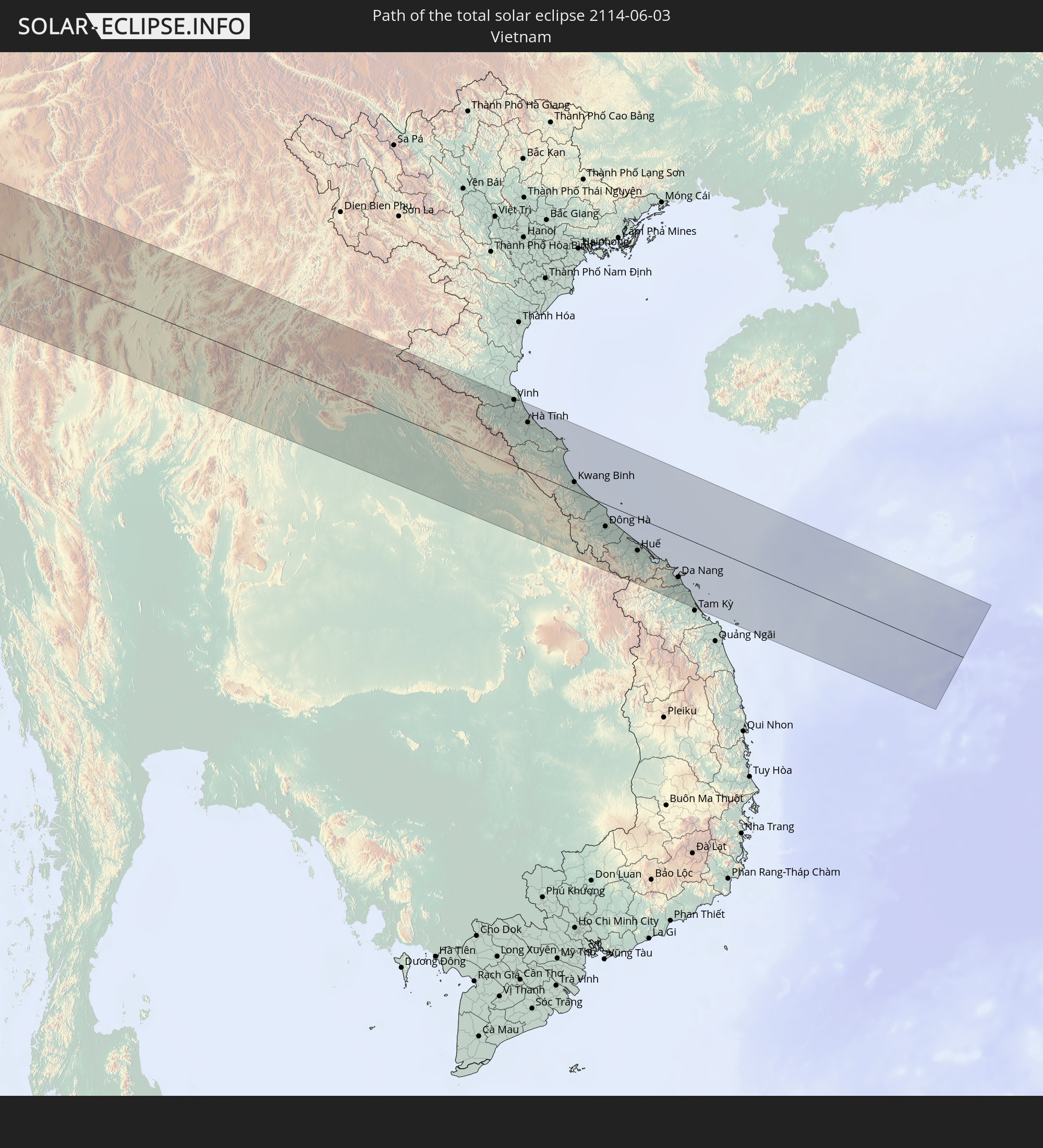 Vietnam
In den folgenden Ländern ist die Sonnenfinsternis partiell zu sehen
 Russia
 Portugal
 Cabo Verde
 Spain
Spain
 Senegal
 Mauritania
 The Gambia
 Guinea-Bissau
 Guinea
 Saint Helena, Ascension and Tristan da Cunha
 Sierra Leone
 Morocco
 Mali
Mali
 Liberia
 Algeria
 Ivory Coast
 Burkina Faso
 Gibraltar
 France
 Ghana
Ghana
 Togo
Togo
 Niger
Niger
 Benin
Benin
 Andorra
 Nigeria
 Equatorial Guinea
 Germany
 Switzerland
 São Tomé and Príncipe
 Italy
Italy
 Monaco
 Tunisia
 Cameroon
 Gabon
Gabon
 Libya
Libya
 Liechtenstein
 Austria
 Republic of the Congo
 Angola
 Namibia
 Czechia
 Democratic Republic of the Congo
 San Marino
 Vatican City
 Slovenia
 Chad
Chad
 Croatia
 Poland
 Malta
Malta
 Central African Republic
 Bosnia and Herzegovina
 Hungary
 Slovakia
 Montenegro
 Serbia
 Albania
 Greece
 Botswana
 Romania
 Republic of Macedonia
 Lithuania
 Latvia
 Sudan
Sudan
 Zambia
 Ukraine
 Bulgaria
 Belarus
 Egypt
Egypt
 Zimbabwe
 Turkey
 Moldova
 Rwanda
 Burundi
 Tanzania
 Uganda
 Mozambique
 Cyprus
 Malawi
 Ethiopia
 Kenya
Kenya
 State of Palestine
 Israel
 Saudi Arabia
 Jordan
 Lebanon
 Syria
Syria
 Eritrea
 Iraq
Iraq
 Georgia
 Somalia
 Djibouti
 Yemen
Yemen
 Armenia
 Iran
Iran
 Azerbaijan
 Kazakhstan
 Kuwait
 Bahrain
 Qatar
Qatar
 United Arab Emirates
 Oman
Oman
 Turkmenistan
 Uzbekistan
 Afghanistan
 Pakistan
 Tajikistan
 India
India
 Kyrgyzstan
 Maldives
 China
China
 Sri Lanka
 Nepal
Nepal
 Mongolia
 Bangladesh
 Bhutan
 Myanmar
 Indonesia
 Cocos Islands
 Thailand
 Malaysia
 Laos
Laos
 Vietnam
 Cambodia
 Singapore
 Macau
Macau
 Hong Kong
 Taiwan
 North Korea
 South Korea
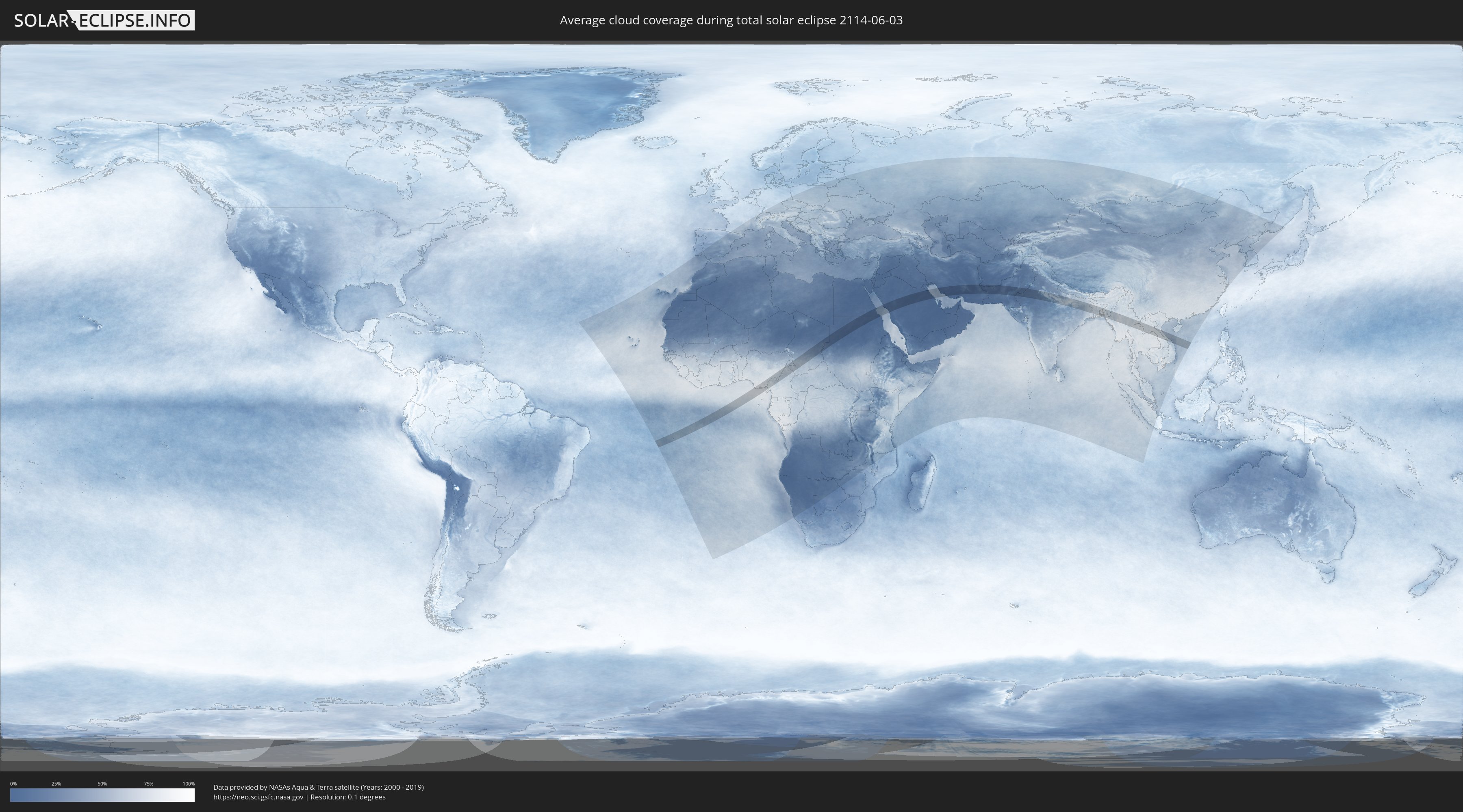
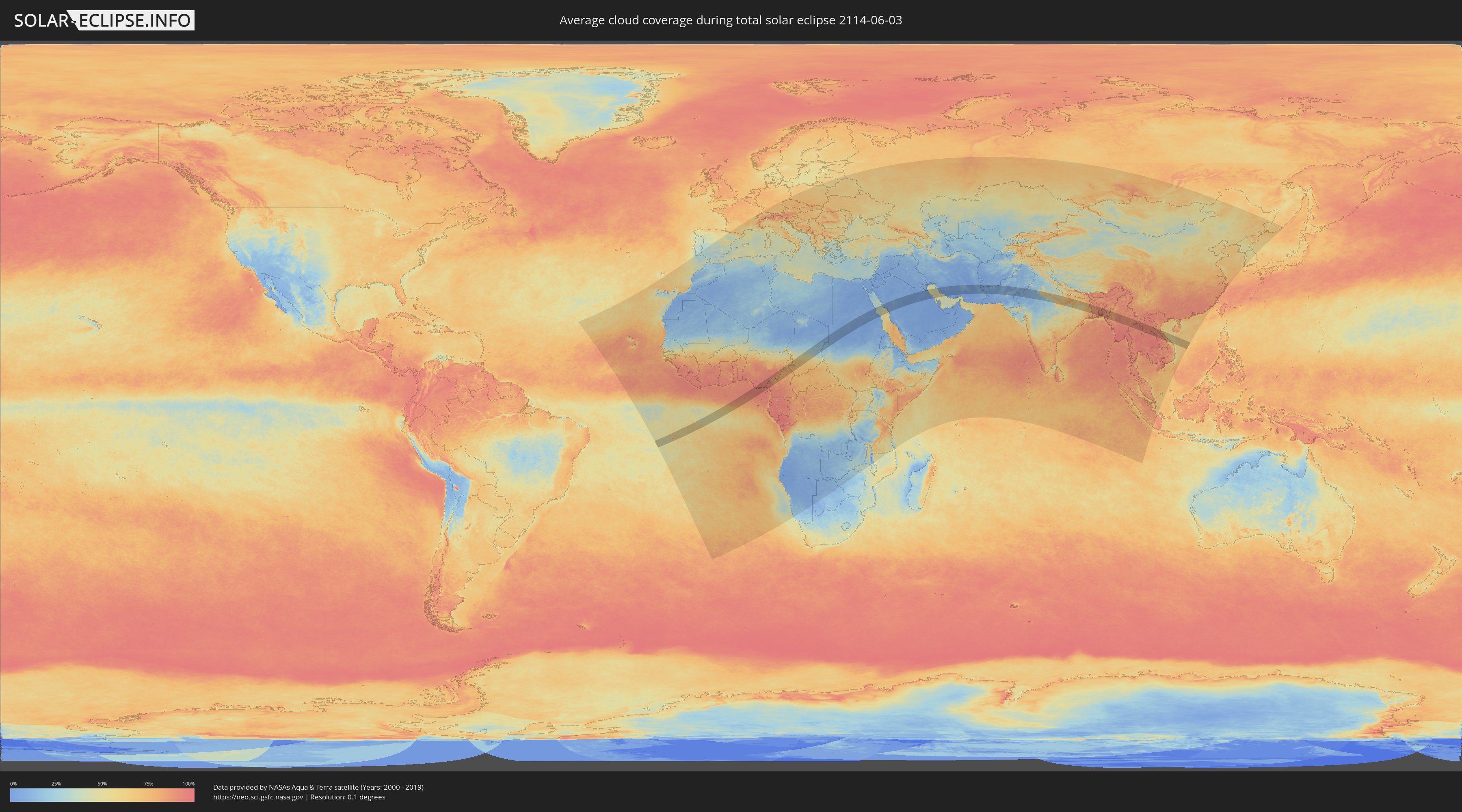
How will be the weather during the total solar eclipse on 06/03/2114?
Where is the best place to see the total solar eclipse of 06/03/2114?
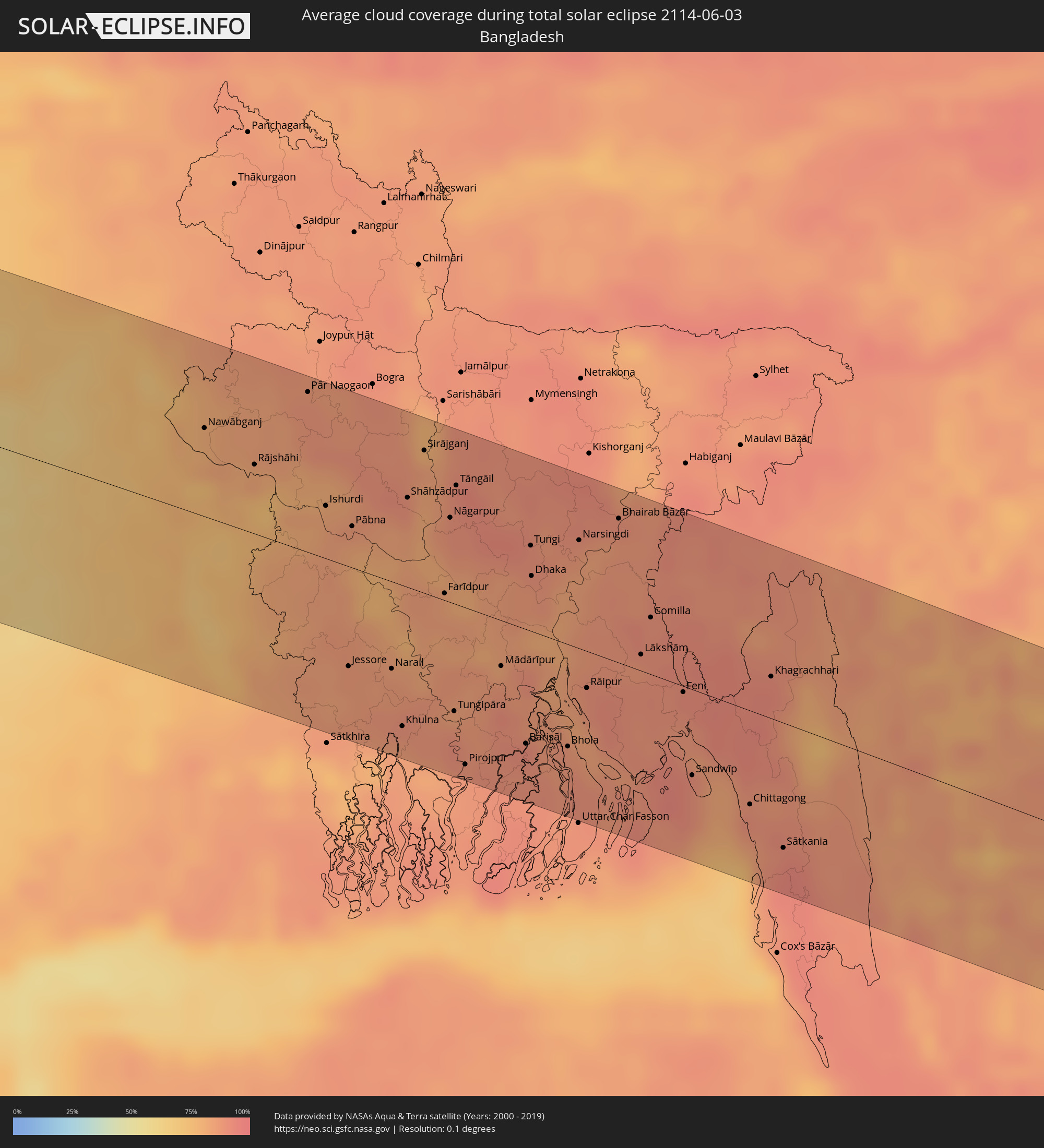
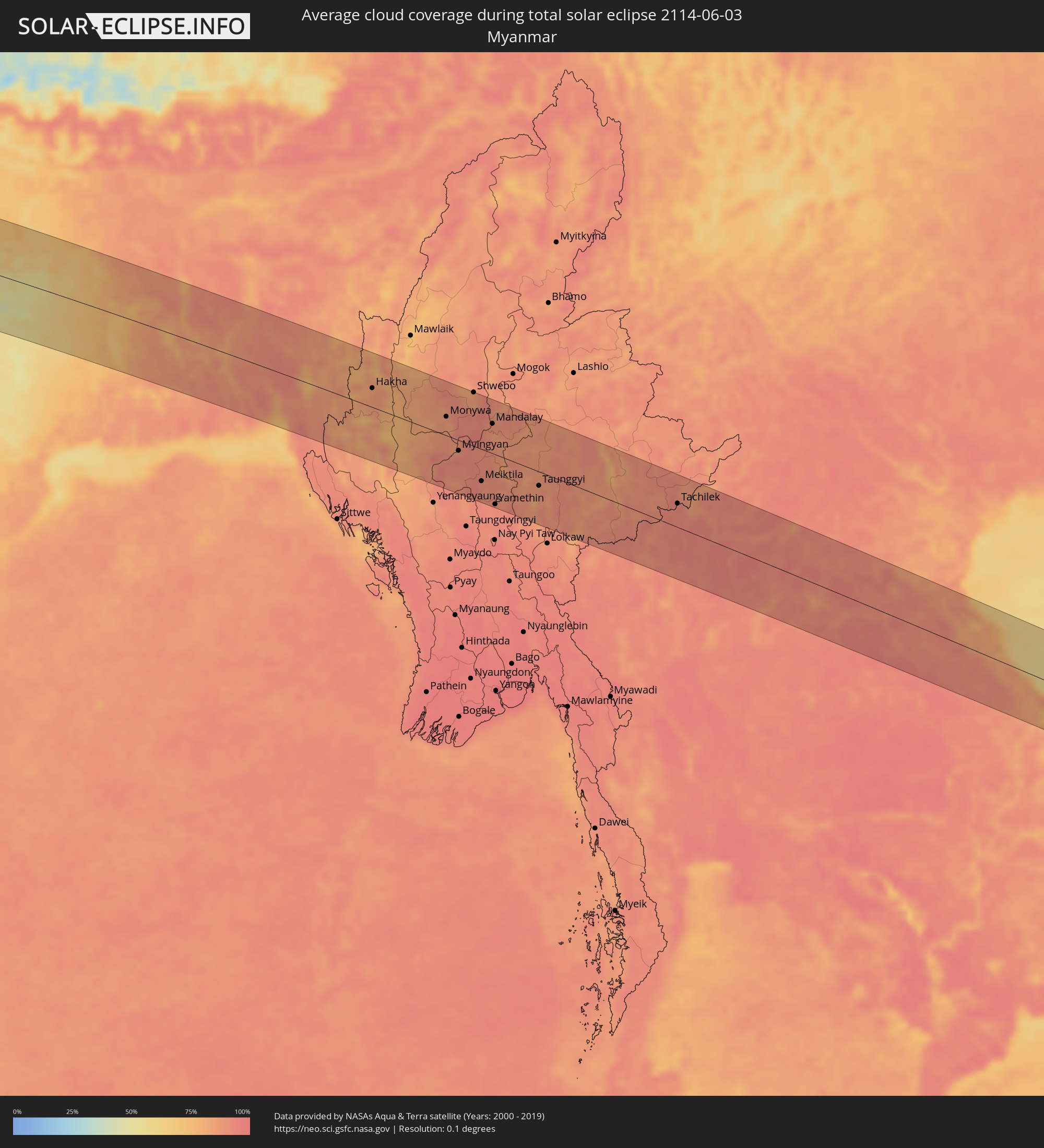
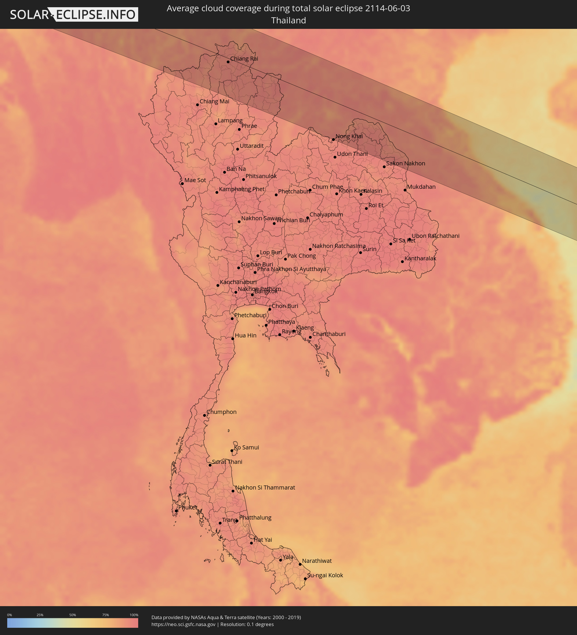
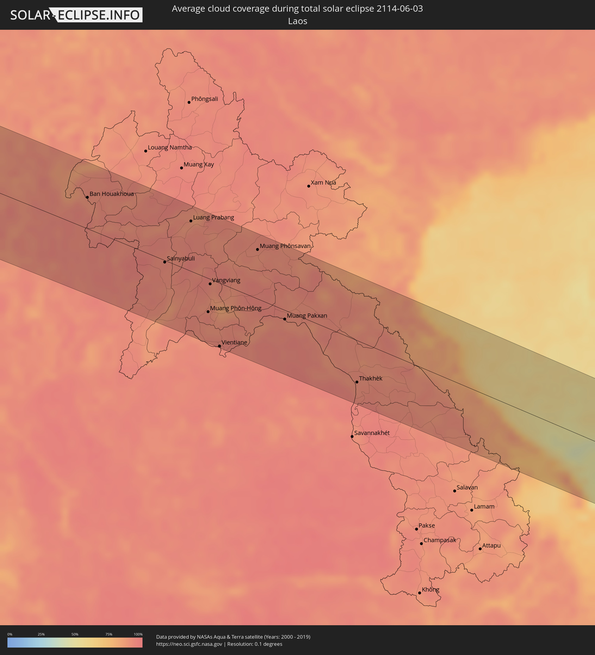
The following maps show the average cloud coverage for the day of the total solar eclipse.
With the help of these maps, it is possible to find the place along the eclipse path, which has the best
chance of a cloudless sky.
Nevertheless, you should consider local circumstances and inform about the weather of your chosen
observation site.
The data is provided by NASAs satellites
AQUA and TERRA.
The cloud maps are averaged over a period of 19 years (2000 - 2019).
Detailed country maps
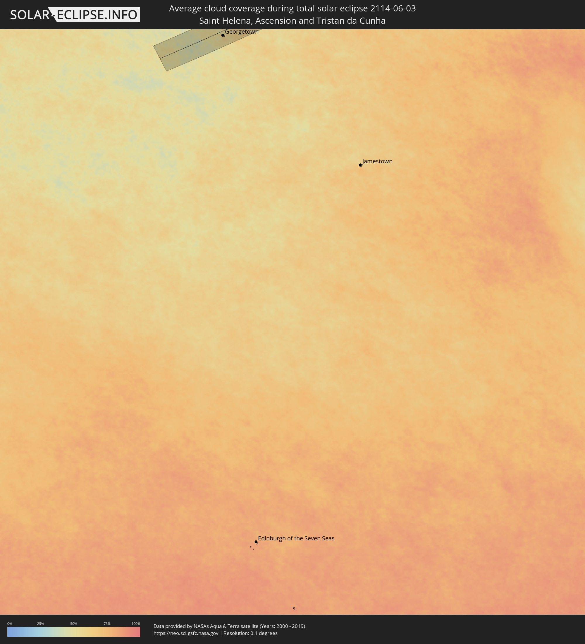 Saint Helena, Ascension and Tristan da Cunha
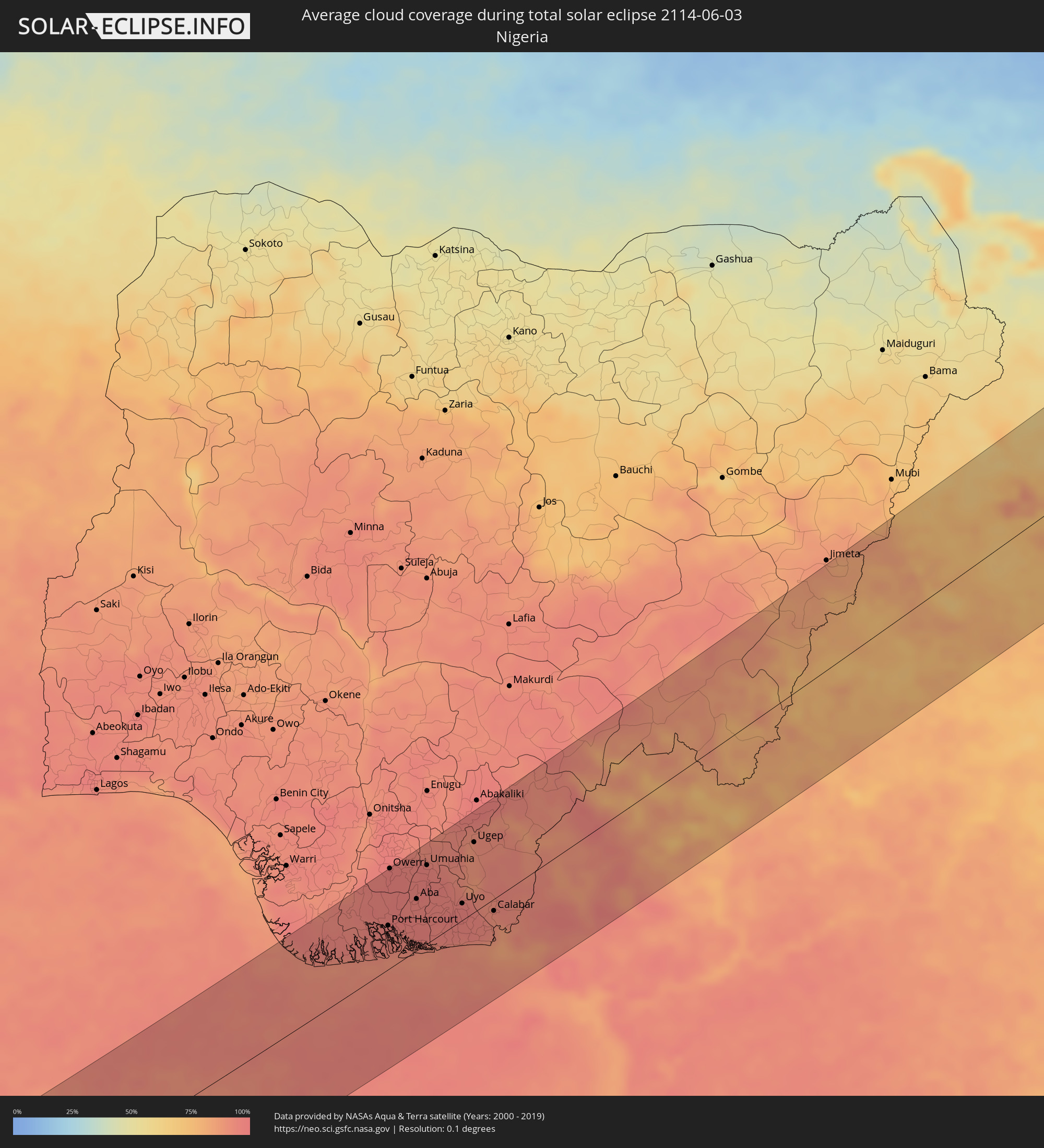 Nigeria
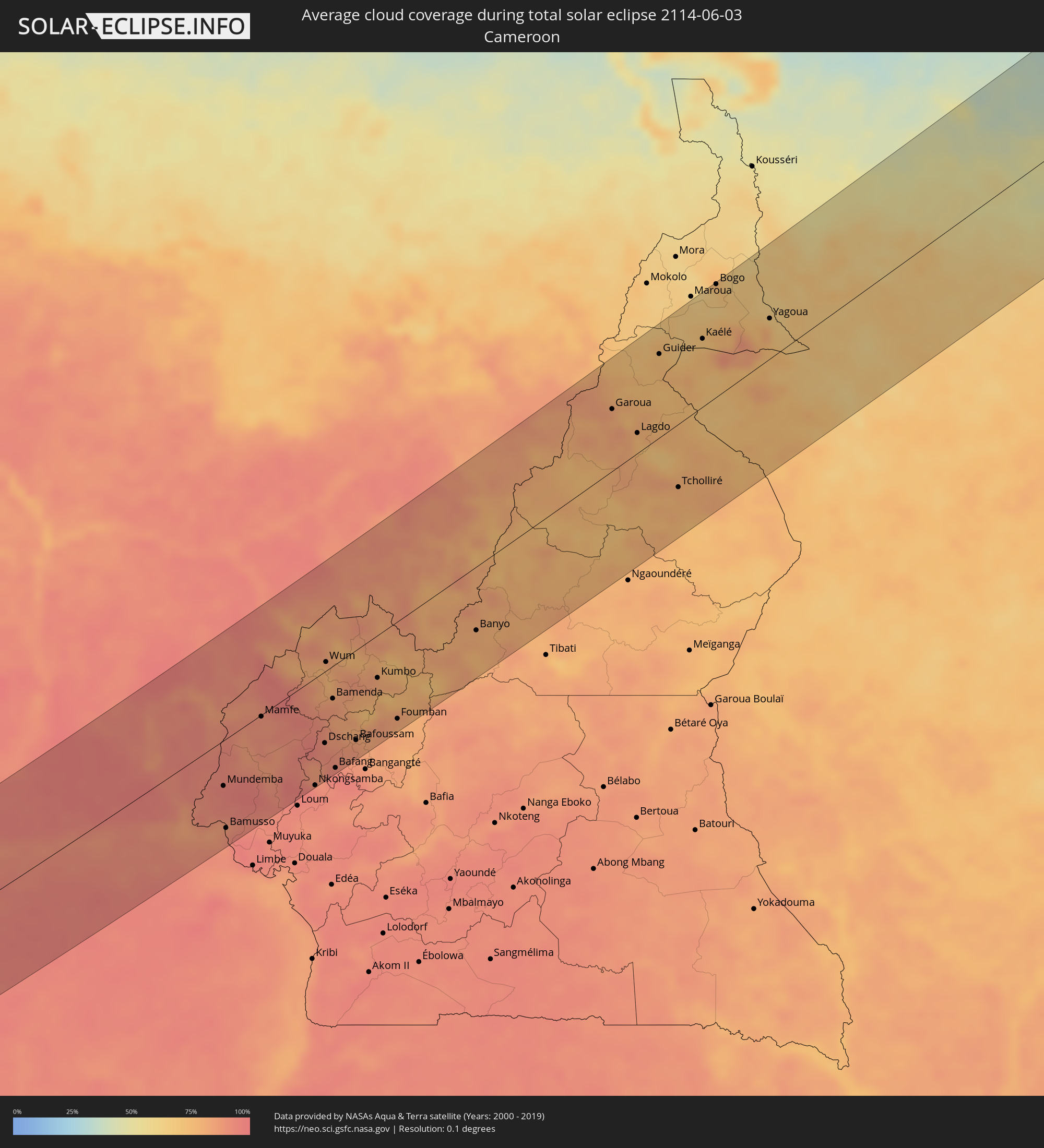 Cameroon
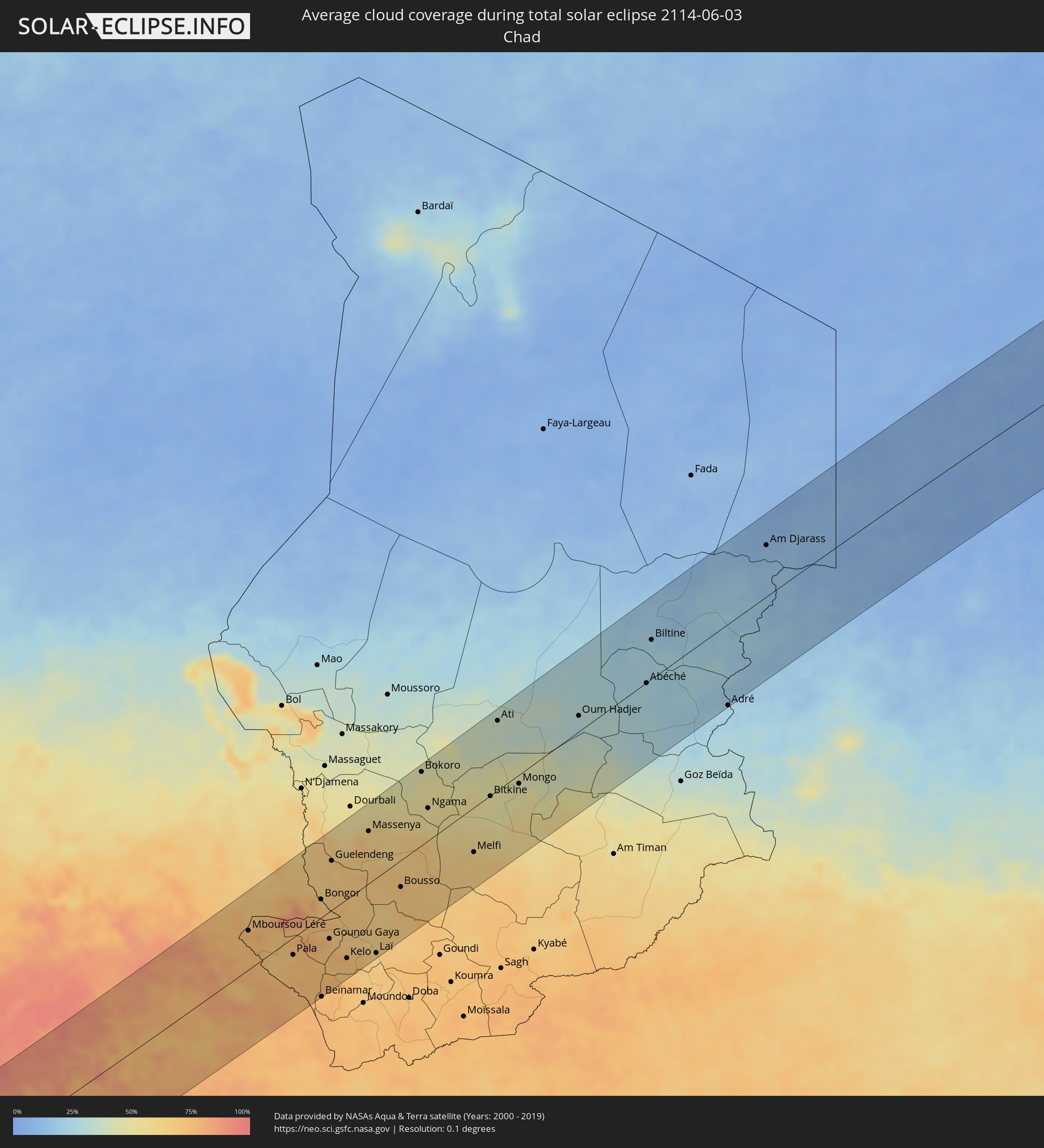 Chad
Chad
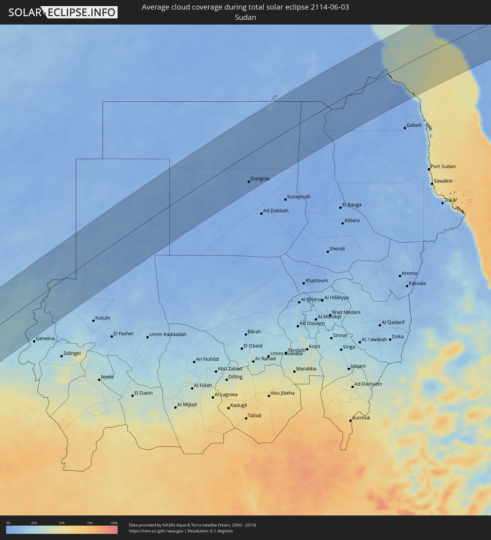 Sudan
Sudan
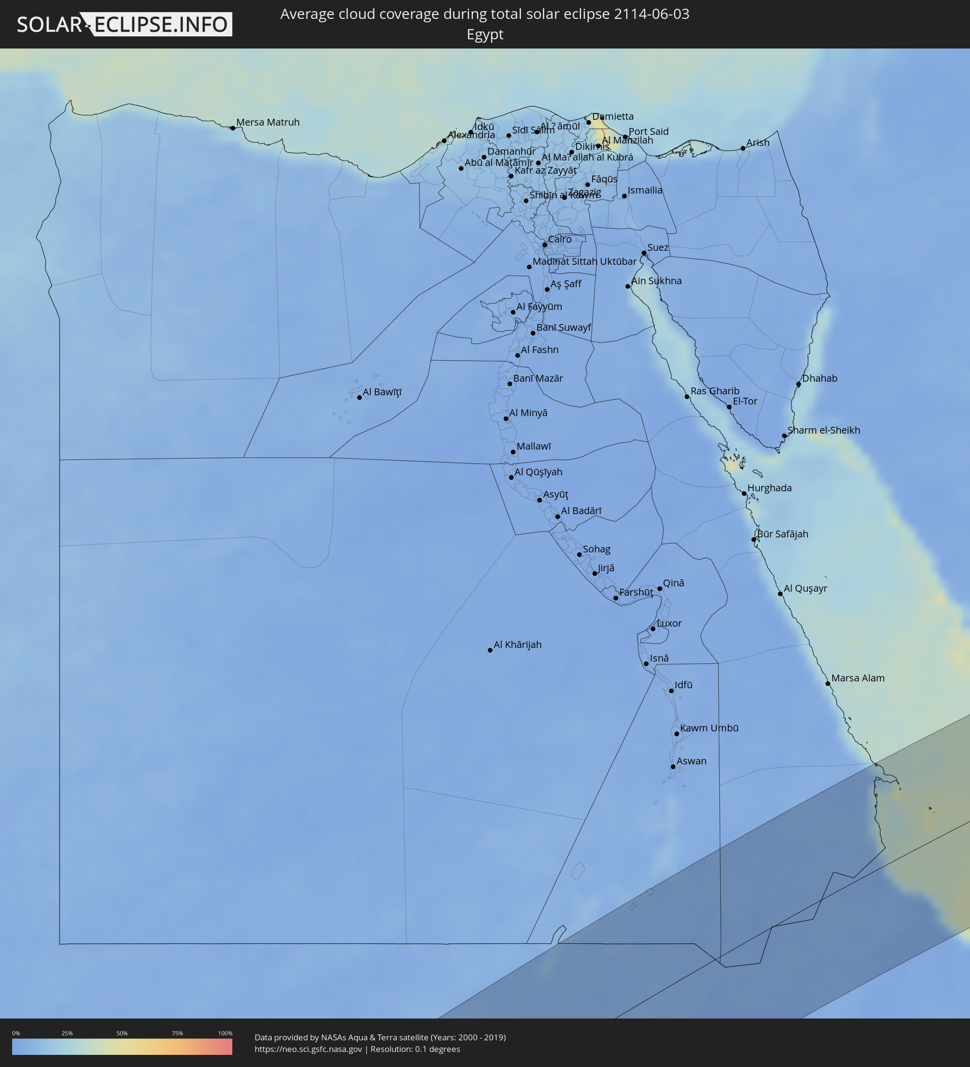 Egypt
Egypt
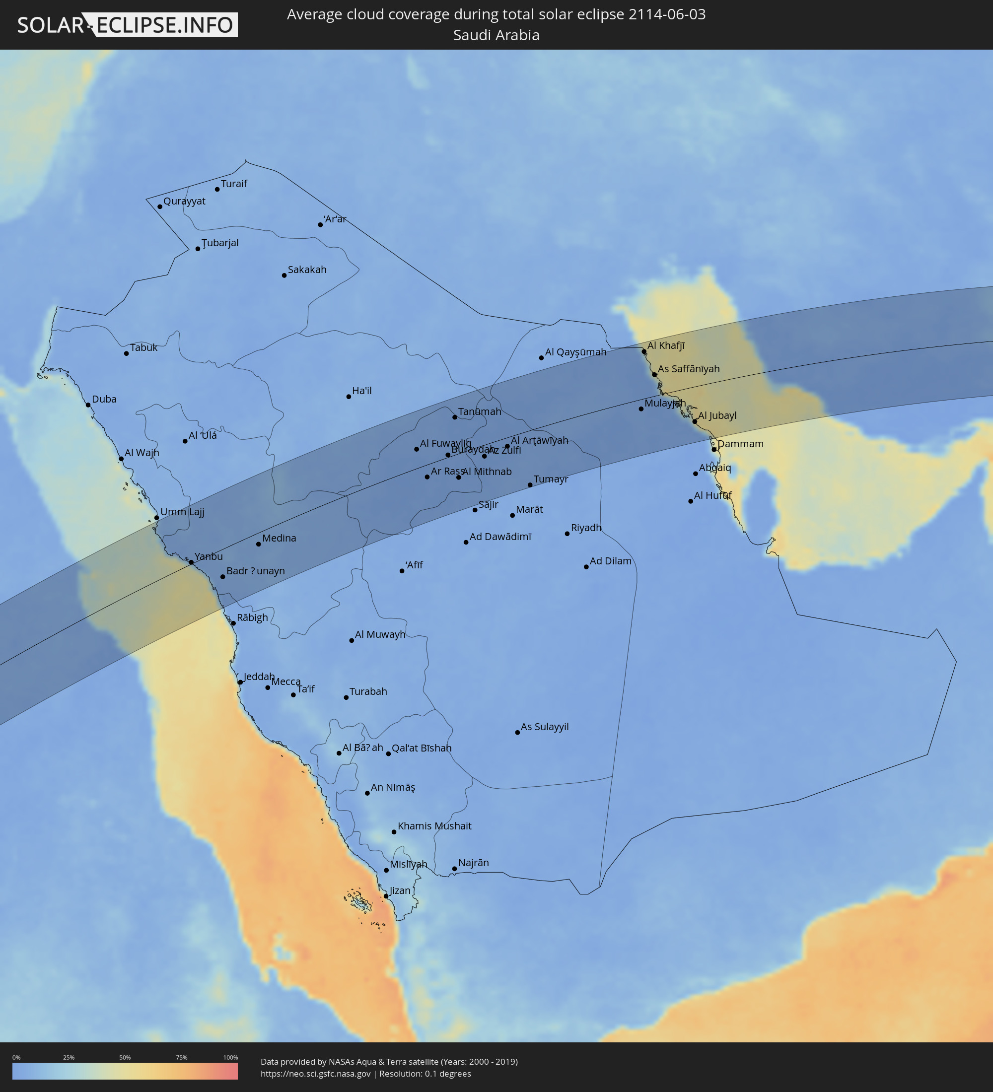 Saudi Arabia
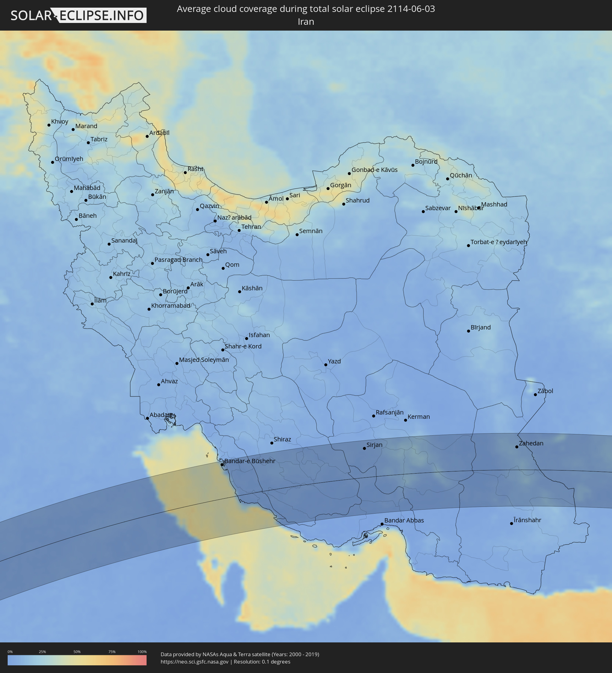 Iran
Iran
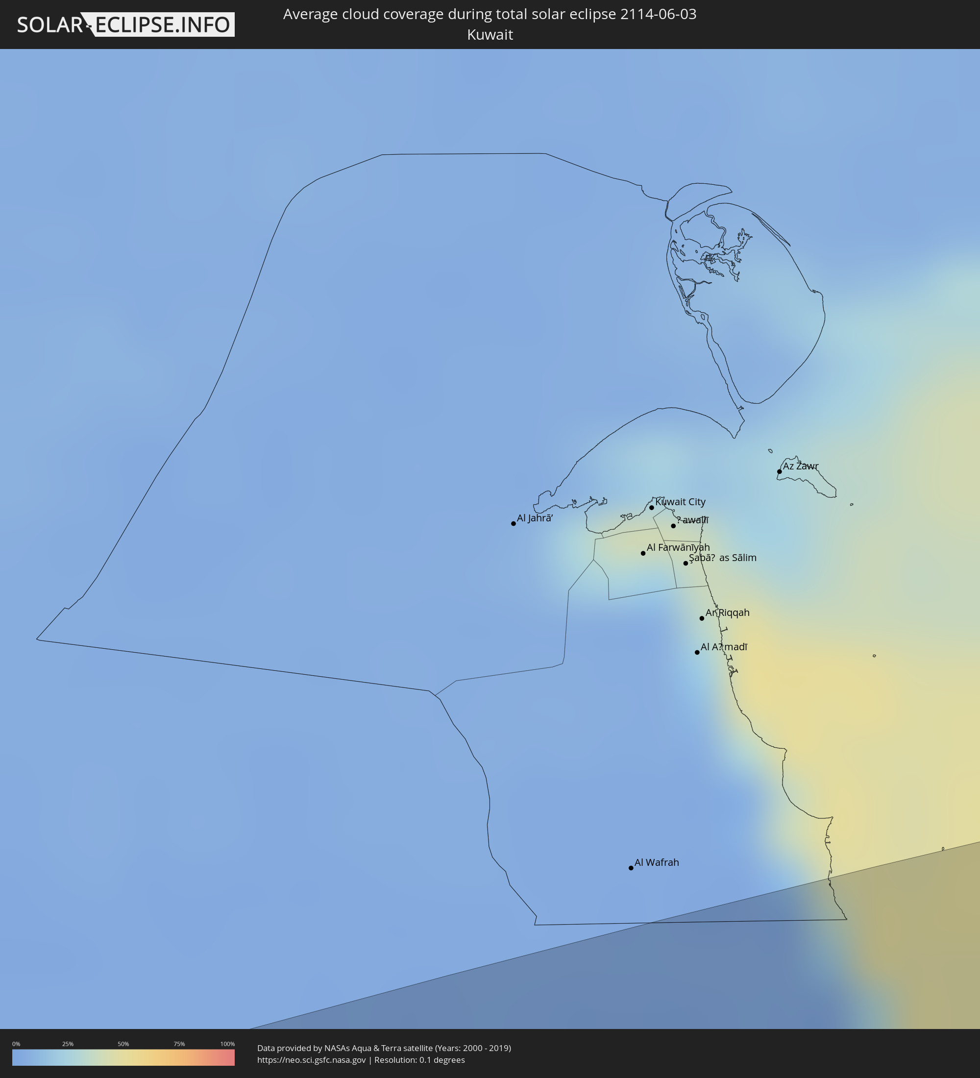 Kuwait
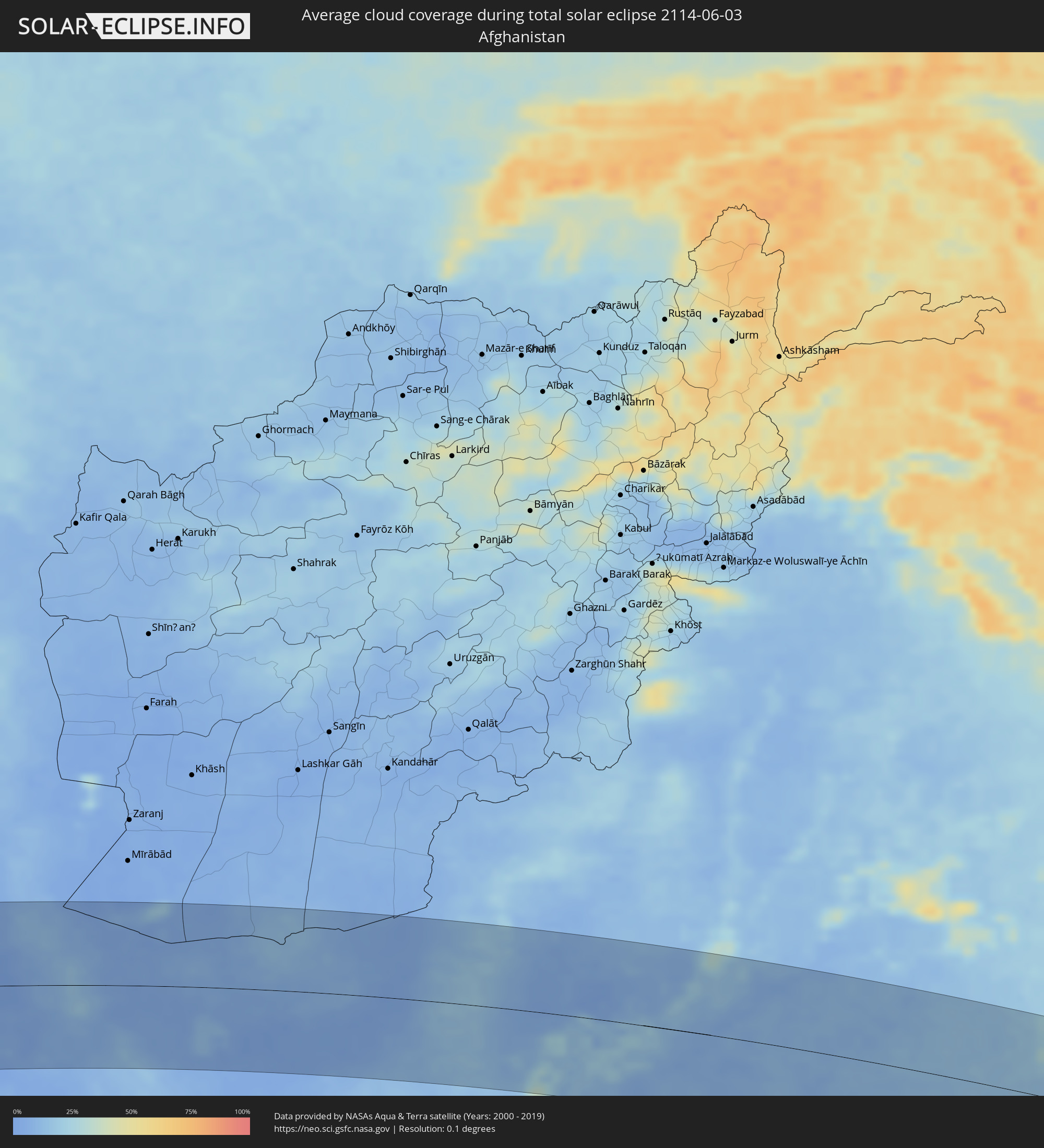 Afghanistan
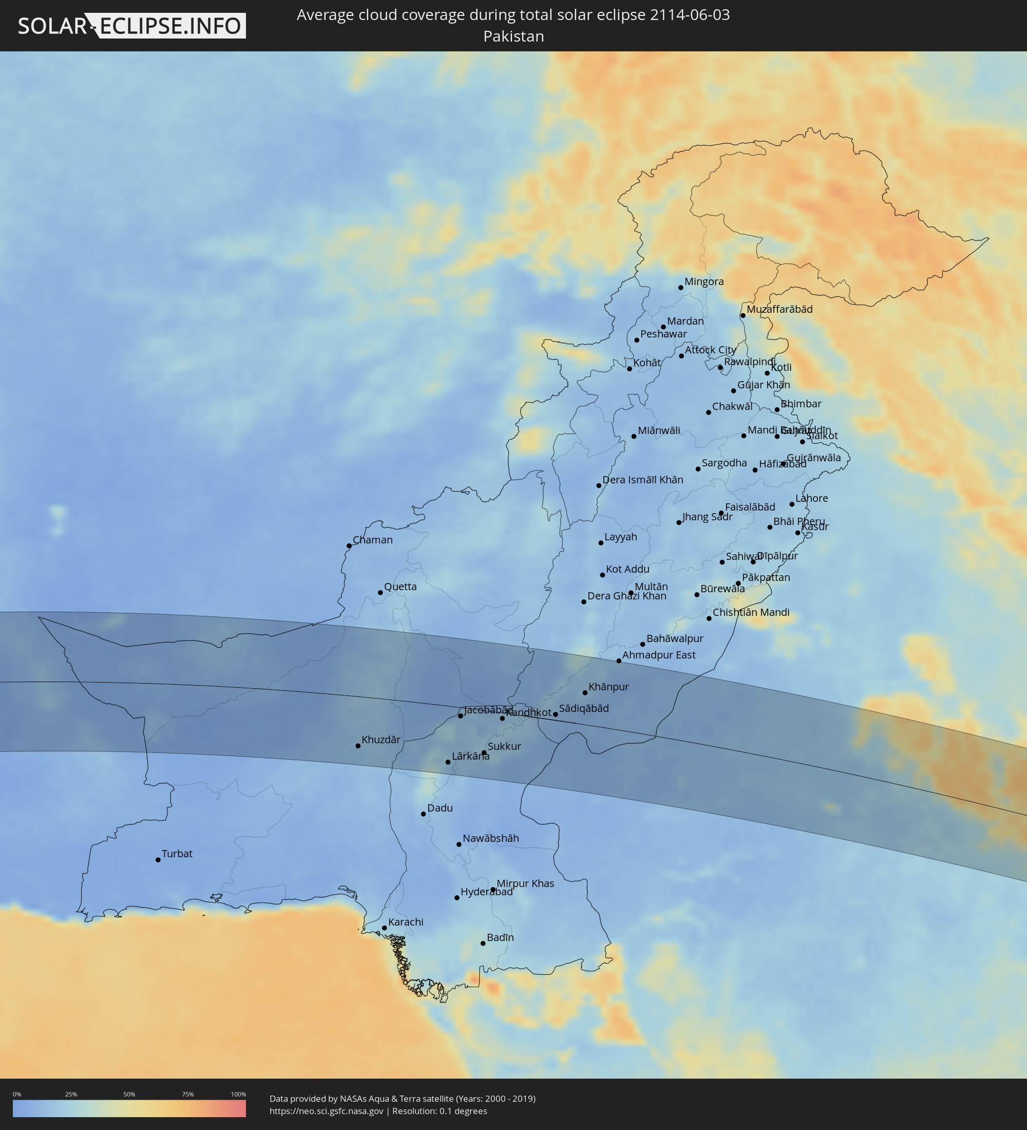 Pakistan
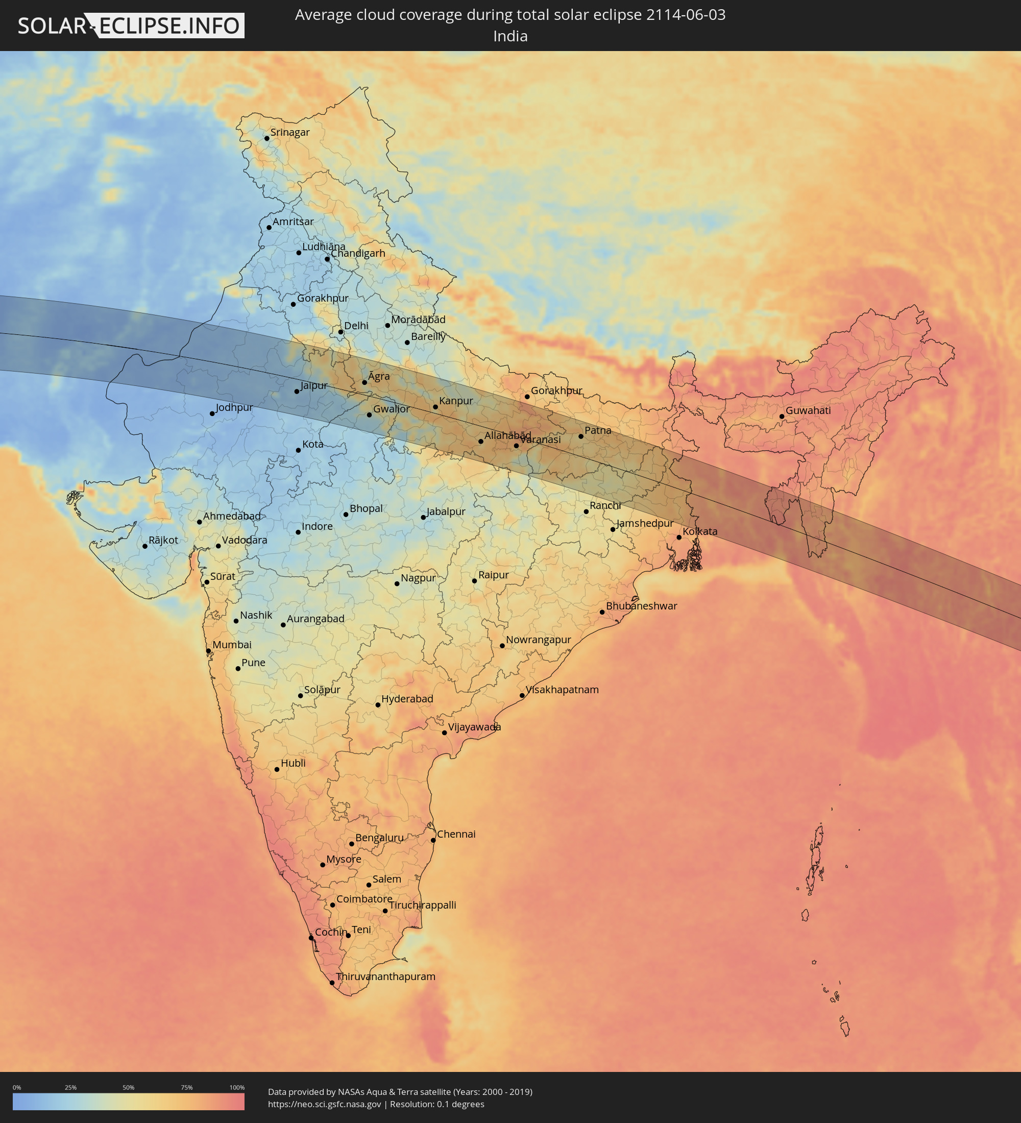 India
India
 Bangladesh
 Myanmar
 Thailand
 Laos
Laos
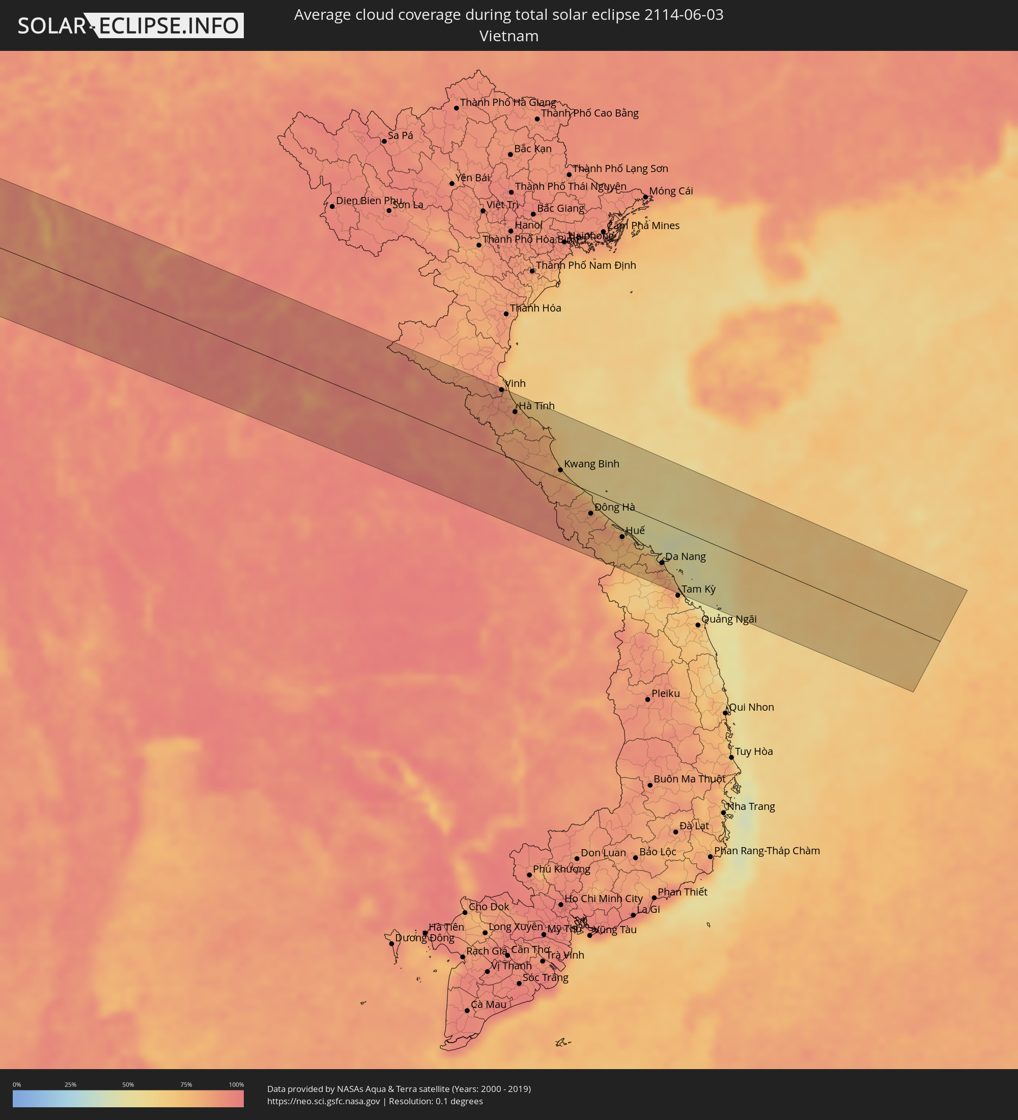 Vietnam
Cities inside the path of the eclipse
The following table shows all locations with a population of more than 5,000 inside the eclipse path. Cities which have more than 100,000 inhabitants are marked bold. A click at the locations opens a detailed map.
| City | Type | Eclipse duration | Local time of max. eclipse | Distance to central line | Ø Cloud coverage |
|
Georgetown, Ascension
|
total | - | 07:27:38 UTC+00:00 | 30 km | 63% |
|
Buguma, Rivers
|
total | - | 08:43:48 UTC+01:00 | 56 km | 96% |
|
Port Harcourt, Rivers
|
total | - | 08:43:58 UTC+01:00 | 50 km | 96% |
|
Owerri, Imo
|
total | - | 08:44:44 UTC+01:00 | 115 km | 97% |
|
Aba, Abia
|
total | - | 08:44:35 UTC+01:00 | 59 km | 96% |
|
Umuahia, Abia
|
total | - | 08:45:09 UTC+01:00 | 90 km | 96% |
|
Bende, Abia
|
total | - | 08:45:18 UTC+01:00 | 85 km | 94% |
|
Ikot Ekpene, Akwa Ibom
|
total | - | 08:44:57 UTC+01:00 | 45 km | 96% |
|
Ohafia-Ifigh, Abia
|
total | - | 08:45:30 UTC+01:00 | 79 km | 93% |
|
Amaigbo, Abia
|
total | - | 08:45:43 UTC+01:00 | 93 km | 94% |
|
Uyo, Akwa Ibom
|
total | - | 08:44:59 UTC+01:00 | 19 km | 97% |
|
Ugep, Cross River
|
total | - | 08:45:56 UTC+01:00 | 80 km | 92% |
|
Esuk Oron, Akwa Ibom
|
total | - | 08:44:58 UTC+01:00 | 24 km | 92% |
|
Calabar, Cross River
|
total | - | 08:45:12 UTC+01:00 | 14 km | 92% |
|
Ikom, Cross River
|
total | - | 08:46:38 UTC+01:00 | 56 km | 85% |
|
Kumba, South-West
|
total | - | 08:45:48 UTC+01:00 | 113 km | 93% |
|
Nkongsamba, Littoral
|
total | - | 08:46:35 UTC+01:00 | 114 km | 94% |
|
Bali, North-West
|
total | - | 08:47:42 UTC+01:00 | 33 km | 88% |
|
Dschang, West
|
total | - | 08:47:14 UTC+01:00 | 76 km | 92% |
|
Wum, North-West
|
total | - | 08:48:19 UTC+01:00 | 9 km | 80% |
|
Bamenda, North-West
|
total | - | 08:47:54 UTC+01:00 | 35 km | 86% |
|
Bafang, West
|
total | - | 08:47:01 UTC+01:00 | 110 km | 94% |
|
Mbouda, West
|
total | - | 08:47:37 UTC+01:00 | 72 km | 83% |
|
Bafoussam, West
|
total | - | 08:47:36 UTC+01:00 | 96 km | 86% |
|
Foumbot, West
|
total | - | 08:47:50 UTC+01:00 | 107 km | 83% |
|
Kumbo, North-West
|
total | - | 08:48:39 UTC+01:00 | 45 km | 81% |
|
Foumban, West
|
total | - | 08:48:20 UTC+01:00 | 103 km | 80% |
|
Yola, Adamawa
|
total | - | 08:54:07 UTC+01:00 | 115 km | 85% |
|
Garoua, North
|
total | - | 08:55:14 UTC+01:00 | 65 km | 80% |
|
Guider, North
|
total | - | 08:56:40 UTC+01:00 | 87 km | 74% |
|
Mboursou Léré, Mayo-Kebbi Ouest
|
total | - | 08:56:41 UTC+01:00 | 58 km | 76% |
|
Pala, Mayo-Kebbi Ouest
|
total | - | 08:57:02 UTC+01:00 | 26 km | 71% |
|
Yagoua, Far North
|
total | - | 08:58:42 UTC+01:00 | 42 km | 80% |
|
Bongor, Mayo-Kebbi Est
|
total | - | 08:58:48 UTC+01:00 | 27 km | 68% |
|
Kelo, Tandjilé
|
total | - | 08:58:02 UTC+01:00 | 88 km | 73% |
|
Béré, Tandjilé
|
total | - | 08:58:29 UTC+01:00 | 110 km | 68% |
|
Laï, Tandjilé
|
total | - | 08:58:46 UTC+01:00 | 112 km | 65% |
|
Bousso, Chari-Baguirmi
|
total | - | 09:00:44 UTC+01:00 | 40 km | 70% |
|
Bokoro, Hadjer-Lamis
|
total | - | 09:03:47 UTC+01:00 | 109 km | 49% |
|
Ngama, Chari-Baguirmi
|
total | - | 09:03:06 UTC+01:00 | 48 km | 54% |
|
Bitkine, Guéra
|
total | - | 09:04:47 UTC+01:00 | 1 km | 49% |
|
Ati, Batha
|
total | - | 09:06:42 UTC+01:00 | 102 km | 37% |
|
Mongo, Guéra
|
total | - | 09:05:45 UTC+01:00 | 13 km | 45% |
|
Oum Hadjer, Batha
|
total | - | 09:08:46 UTC+01:00 | 23 km | 30% |
|
Abéché, Ouadaï
|
total | - | 09:11:15 UTC+01:00 | 1 km | 26% |
|
Adré, Ouadaï
|
total | - | 09:12:52 UTC+01:00 | 120 km | 23% |
|
Argo, Northern State
|
total | - | 10:37:13 UTC+02:00 | 57 km | 5% |
|
Dongola, Northern State
|
total | - | 10:36:50 UTC+02:00 | 92 km | 6% |
|
Yanbu, Al Madīnah al Munawwarah
|
total | - | 12:00:53 UTC+03:00 | 2 km | 28% |
|
Badr Ḩunayn, Al Madīnah al Munawwarah
|
total | - | 12:02:15 UTC+03:00 | 61 km | 5% |
|
Medina, Al Madīnah al Munawwarah
|
total | - | 12:05:06 UTC+03:00 | 26 km | 6% |
|
Ar Rass, Al-Qassim
|
total | - | 12:16:13 UTC+03:00 | 28 km | 1% |
|
Al Bukayrīyah, Al-Qassim
|
total | - | 12:16:53 UTC+03:00 | 5 km | 3% |
|
Buraydah, Al-Qassim
|
total | - | 12:17:50 UTC+03:00 | 4 km | 2% |
|
Unaizah, Al-Qassim
|
total | - | 12:17:40 UTC+03:00 | 22 km | 2% |
|
Tanūmah, Al-Qassim
|
total | - | 12:18:57 UTC+03:00 | 80 km | 1% |
|
Al Mithnab, Al-Qassim
|
total | - | 12:18:01 UTC+03:00 | 53 km | 3% |
|
Az Zulfi, Ar Riyāḑ
|
total | - | 12:19:55 UTC+03:00 | 26 km | 1% |
|
Al Arţāwīyah, Ar Riyāḑ
|
total | - | 12:21:25 UTC+03:00 | 21 km | 2% |
|
Al Khafjī, Eastern Province
|
total | - | 12:30:37 UTC+03:00 | 102 km | 19% |
|
Al Jubayl, Eastern Province
|
total | - | 12:32:35 UTC+03:00 | 79 km | 22% |
|
Umm as Sāhik, Eastern Province
|
total | - | 12:33:01 UTC+03:00 | 124 km | 2% |
|
Raḩīmah, Eastern Province
|
total | - | 12:33:25 UTC+03:00 | 121 km | 42% |
|
Bandar-e Būshehr, Bushehr
|
total | - | 13:06:32 UTC+03:30 | 110 km | 23% |
|
Fīrūzābād, Fars
|
total | - | 13:10:35 UTC+03:30 | 67 km | 6% |
|
Akbarābād, Fars
|
total | - | 13:11:13 UTC+03:30 | 108 km | 5% |
|
Fasā, Fars
|
total | - | 13:13:09 UTC+03:30 | 61 km | 4% |
|
Gerāsh, Fars
|
total | - | 13:13:53 UTC+03:30 | 86 km | 1% |
|
Neyrīz, Fars
|
total | - | 13:14:48 UTC+03:30 | 81 km | 3% |
|
Dārāb, Fars
|
total | - | 13:15:11 UTC+03:30 | 29 km | 1% |
|
Sirjan, Kerman
|
total | - | 13:17:57 UTC+03:30 | 95 km | 2% |
|
Bam, Kerman
|
total | - | 13:23:52 UTC+03:30 | 37 km | 5% |
|
Zahedan, Sistan and Baluchestan
|
total | - | 13:29:14 UTC+03:30 | 74 km | 9% |
|
Khāsh, Sistan and Baluchestan
|
total | - | 13:30:04 UTC+03:30 | 68 km | 7% |
|
Khuzdār, Balochistān
|
total | - | 15:10:59 UTC+05:00 | 87 km | 13% |
|
Sibi, Balochistān
|
total | - | 15:12:41 UTC+05:00 | 118 km | 9% |
|
Shahdād Kot, Sindh
|
total | - | 15:13:22 UTC+05:00 | 70 km | 24% |
|
Kambar, Sindh
|
total | - | 15:13:37 UTC+05:00 | 98 km | 28% |
|
Lārkāna, Sindh
|
total | - | 15:14:01 UTC+05:00 | 99 km | 18% |
|
Jacobābād, Sindh
|
total | - | 15:14:09 UTC+05:00 | 16 km | 15% |
|
Shikārpur, Sindh
|
total | - | 15:14:38 UTC+05:00 | 49 km | 17% |
|
Khairpur, Sindh
|
total | - | 15:15:00 UTC+05:00 | 95 km | 11% |
|
Sukkur, Sindh
|
total | - | 15:15:07 UTC+05:00 | 74 km | 15% |
|
Pāno Āqil, Sindh
|
total | - | 15:15:30 UTC+05:00 | 54 km | 15% |
|
Kandhkot, Sindh
|
total | - | 15:15:28 UTC+05:00 | 11 km | 20% |
|
Ghotki, Sindh
|
total | - | 15:15:48 UTC+05:00 | 35 km | 14% |
|
Sādiqābād, Punjab
|
total | - | 15:17:03 UTC+05:00 | 9 km | 10% |
|
Rājanpur, Punjab
|
total | - | 15:17:01 UTC+05:00 | 100 km | 14% |
|
Khānpur, Punjab
|
total | - | 15:17:46 UTC+05:00 | 54 km | 10% |
|
Bīkaner, Rajasthan
|
total | - | 15:52:15 UTC+05:30 | 29 km | 14% |
|
Jaipur, Rajasthan
|
total | - | 15:56:25 UTC+05:30 | 41 km | 17% |
|
Āgra, Uttar Pradesh
|
total | - | 15:59:13 UTC+05:30 | 38 km | 44% |
|
Alīgarh, Uttar Pradesh
|
total | - | 15:58:53 UTC+05:30 | 115 km | 50% |
|
Gwalior, Madhya Pradesh
|
total | - | 15:59:59 UTC+05:30 | 62 km | 26% |
|
Kanpur, Uttar Pradesh
|
total | - | 16:02:29 UTC+05:30 | 19 km | 48% |
|
Lucknow, Uttar Pradesh
|
total | - | 16:02:53 UTC+05:30 | 74 km | 51% |
|
Allahābād, Uttar Pradesh
|
total | - | 16:04:46 UTC+05:30 | 50 km | 65% |
|
Varanasi, Uttar Pradesh
|
total | - | 16:06:05 UTC+05:30 | 31 km | 59% |
|
Gaya, Bihar
|
total | - | 16:08:20 UTC+05:30 | 27 km | 61% |
|
Patna, Bihar
|
total | - | 16:07:57 UTC+05:30 | 62 km | 57% |
|
Bokāro, Jharkhand
|
total | - | 16:09:50 UTC+05:30 | 104 km | 54% |
|
Bhāgalpur, Bihar
|
total | - | 16:09:46 UTC+05:30 | 82 km | 66% |
|
Āsansol, West Bengal
|
total | - | 16:10:46 UTC+05:30 | 82 km | 63% |
|
Durgapur, West Bengal
|
total | - | 16:11:08 UTC+05:30 | 90 km | 63% |
|
Nawābganj, Rājshāhi
|
total | - | 16:41:14 UTC+06:00 | 55 km | 79% |
|
Rājshāhi, Rājshāhi
|
total | - | 16:41:37 UTC+06:00 | 43 km | 82% |
|
Pār Naogaon, Rājshāhi
|
total | - | 16:41:36 UTC+06:00 | 100 km | 88% |
|
Kushtia, Khulna
|
total | - | 16:42:18 UTC+06:00 | 11 km | 84% |
|
Jessore, Khulna
|
total | - | 16:42:49 UTC+06:00 | 63 km | 86% |
|
Pābna, Rājshāhi
|
total | - | 16:42:19 UTC+06:00 | 26 km | 83% |
|
Khulna, Khulna
|
total | - | 16:43:18 UTC+06:00 | 89 km | 86% |
|
Nāgarpur, Dhaka
|
total | - | 16:42:44 UTC+06:00 | 53 km | 89% |
|
Tāngāil, Dhaka
|
total | - | 16:42:39 UTC+06:00 | 74 km | 89% |
|
Barisāl, Barisāl
|
total | - | 16:43:55 UTC+06:00 | 72 km | 91% |
|
Tungi, Dhaka
|
total | - | 16:43:12 UTC+06:00 | 54 km | 90% |
|
Dhaka, Dhaka
|
total | - | 16:43:19 UTC+06:00 | 35 km | 87% |
|
Narsingdi, Dhaka
|
total | - | 16:43:24 UTC+06:00 | 68 km | 87% |
|
Comilla, Chittagong
|
total | - | 16:43:59 UTC+06:00 | 36 km | 90% |
|
Chittagong, Chittagong
|
total | - | 16:45:04 UTC+06:00 | 59 km | 86% |
|
Hakha, Chin
|
total | - | 17:15:54 UTC+06:30 | 38 km | 83% |
|
Falam, Chin
|
total | - | 17:15:46 UTC+06:30 | 67 km | 82% |
|
Chauk, Magway
|
total | - | 17:17:32 UTC+06:30 | 100 km | 89% |
|
Pakokku, Magway
|
total | - | 17:17:24 UTC+06:30 | 45 km | 93% |
|
Monywa, Sagain
|
total | - | 17:16:59 UTC+06:30 | 37 km | 86% |
|
Myingyan, Mandalay
|
total | - | 17:17:29 UTC+06:30 | 21 km | 90% |
|
Shwebo, Sagain
|
total | - | 17:16:58 UTC+06:30 | 106 km | 86% |
|
Meiktila, Mandalay
|
total | - | 17:18:01 UTC+06:30 | 64 km | 89% |
|
Sagaing, Sagain
|
total | - | 17:17:30 UTC+06:30 | 45 km | 87% |
|
Mandalay, Mandalay
|
total | - | 17:17:29 UTC+06:30 | 59 km | 90% |
|
Kyaukse, Mandalay
|
total | - | 17:17:43 UTC+06:30 | 22 km | 88% |
|
Yamethin, Mandalay
|
total | - | 17:18:23 UTC+06:30 | 99 km | 92% |
|
Pyin Oo Lwin, Mandalay
|
total | - | 17:17:36 UTC+06:30 | 79 km | 89% |
|
Taunggyi, Shan
|
total | - | 17:18:33 UTC+06:30 | 28 km | 86% |
|
Chiang Rai, Chiang Rai
|
total | - | 17:49:58 UTC+07:00 | 11 km | 94% |
|
Mae Chan, Chiang Rai
|
total | - | 17:49:51 UTC+07:00 | 15 km | 93% |
|
Mae Sai, Chiang Rai
|
total | - | 17:49:42 UTC+07:00 | 45 km | 94% |
|
Tachilek, Shan
|
total | - | 17:49:41 UTC+07:00 | 47 km | 94% |
|
Pa Daet, Chiang Rai
|
total | - | 17:50:13 UTC+07:00 | 46 km | 93% |
|
Dok Kham Tai, Phayao
|
total | - | 17:50:24 UTC+07:00 | 81 km | 92% |
|
Pong, Phayao
|
total | - | 17:50:29 UTC+07:00 | 71 km | 91% |
|
Chiang Kham, Phayao
|
total | - | 17:50:18 UTC+07:00 | 32 km | 94% |
|
Chiang Khong, Chiang Rai
|
total | - | 17:49:56 UTC+07:00 | 48 km | 91% |
|
Ban Houayxay, Bokeo Province
|
total | - | 17:49:55 UTC+07:00 | 50 km | 91% |
|
Ban Houakhoua, Bokeo Province
|
total | - | 17:49:57 UTC+07:00 | 49 km | 90% |
|
Nan, Nan
|
total | - | 17:50:47 UTC+07:00 | 89 km | 93% |
|
Chiang Klang, Nan
|
total | - | 17:50:33 UTC+07:00 | 33 km | 93% |
|
Sainyabuli, Xiagnabouli
|
total | - | 17:50:46 UTC+07:00 | 3 km | 92% |
|
Luang Prabang, Louangphabang
|
total | - | 17:50:31 UTC+07:00 | 79 km | 89% |
|
Muang Phôn-Hông, Vientiane Province
|
total | - | 17:51:17 UTC+07:00 | 53 km | 94% |
|
Vangviang, Vientiane Province
|
total | - | 17:51:04 UTC+07:00 | 8 km | 92% |
|
Si Chiang Mai, Nong Khai
|
total | - | 17:51:34 UTC+07:00 | 102 km | 93% |
|
Vientiane, Vientiane
|
total | - | 17:51:34 UTC+07:00 | 100 km | 93% |
|
Phon Charoen, Nong Khai
|
total | - | 17:51:38 UTC+07:00 | 70 km | 94% |
|
Muang Phônsavan, Xiangkhoang
|
total | - | 17:50:56 UTC+07:00 | 77 km | 89% |
|
Ban Dung, Changwat Udon Thani
|
total | - | 17:51:48 UTC+07:00 | 101 km | 94% |
|
Muang Pakxan, Bolikhamsai Province
|
total | - | 17:51:32 UTC+07:00 | 14 km | 89% |
|
Seka, Changwat Bueng Kan
|
total | - | 17:51:47 UTC+07:00 | 49 km | 95% |
|
Nakhon Phanom, Nakhon Phanom
|
total | - | 17:52:07 UTC+07:00 | 68 km | 91% |
|
Thakhèk, Khammouan
|
total | - | 17:52:07 UTC+07:00 | 66 km | 91% |
|
Yên Vinh, Nghệ An
|
total | - | 17:51:37 UTC+07:00 | 97 km | 85% |
|
Vinh, Nghệ An
|
total | - | 17:51:36 UTC+07:00 | 99 km | 85% |
|
Hà Tĩnh, Hà Tĩnh
|
total | - | 17:51:47 UTC+07:00 | 74 km | 83% |
|
Kwang Binh, Quảng Bình
|
total | - | 17:52:13 UTC+07:00 | 14 km | 81% |
|
Ðông Hà, Quảng Trị
|
total | - | 17:52:31 UTC+07:00 | 34 km | 81% |
|
Huế, Thừa Thiên-Huế
|
total | - | 17:52:40 UTC+07:00 | 49 km | 79% |
|
Da Nang, Đà Nẵng
|
total | - | 17:52:50 UTC+07:00 | 64 km | 79% |
|
Hội An, Quảng Nam
|
total | - | 17:52:54 UTC+07:00 | 78 km | 81% |