Total solar eclipse of 12/03/2719
| Day of week: | Wednesday |
| Maximum duration of eclipse: | 03m01s |
| Maximum width of eclipse path: | 180 km |
| Saros cycle: | 173 |
| Coverage: | 100% |
| Magnitude: | 1.0331 |
| Gamma: | 0.7837 |
Wo kann man die Sonnenfinsternis vom 12/03/2719 sehen?
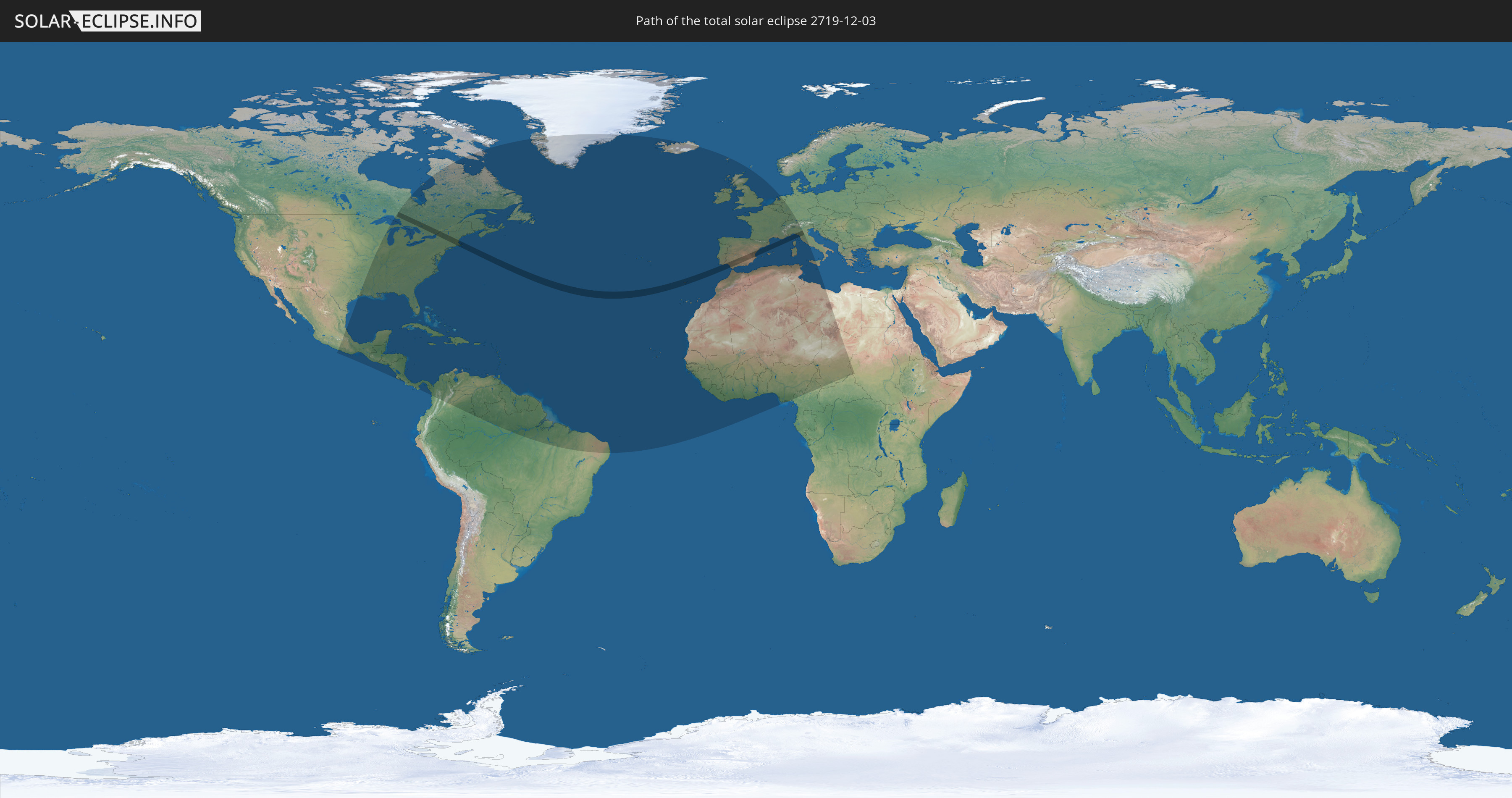
Die Sonnenfinsternis am 12/03/2719 kann man in 92 Ländern als partielle Sonnenfinsternis beobachten.
Der Finsternispfad verläuft durch 6 Länder. Nur in diesen Ländern ist sie als total Sonnenfinsternis zu sehen.
In den folgenden Ländern ist die Sonnenfinsternis total zu sehen
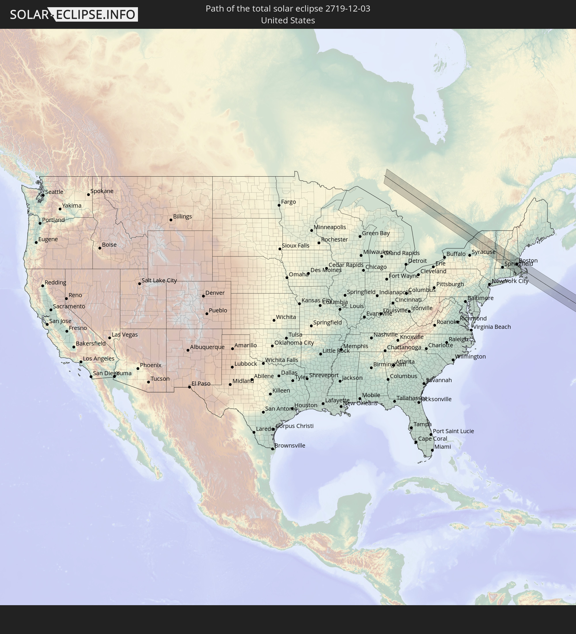 United States
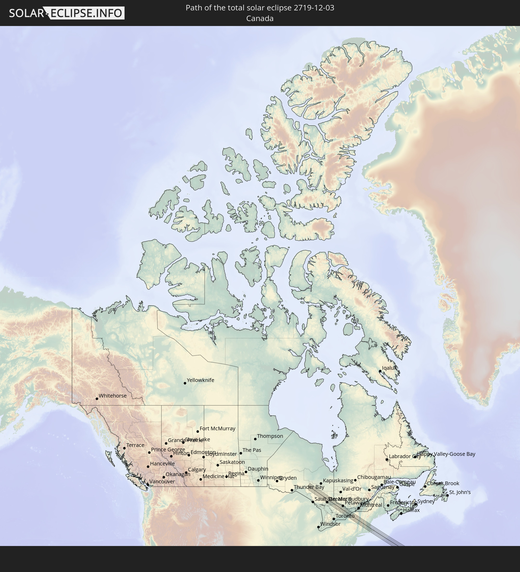 Canada
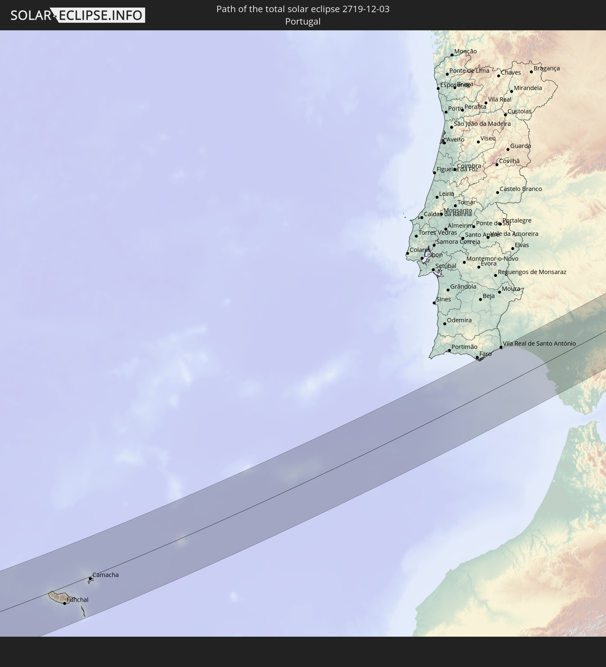 Portugal
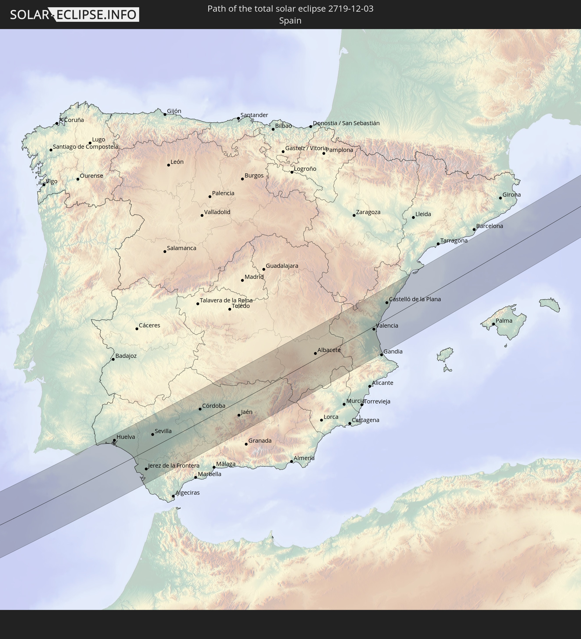 Spain
Spain
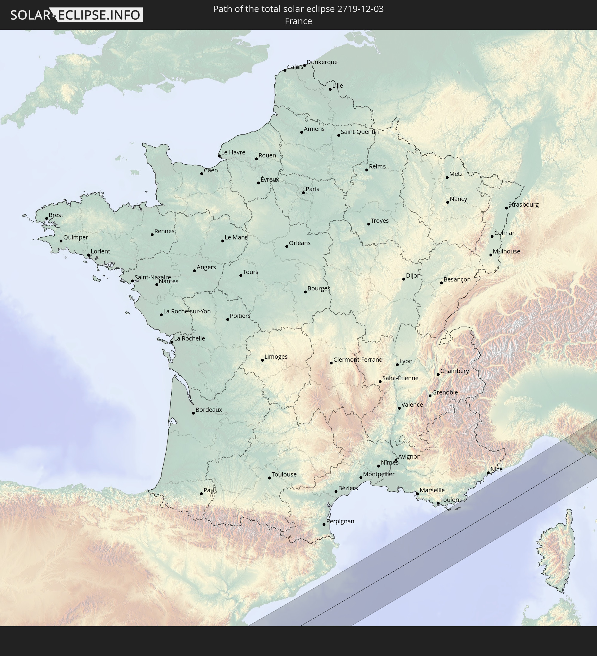 France
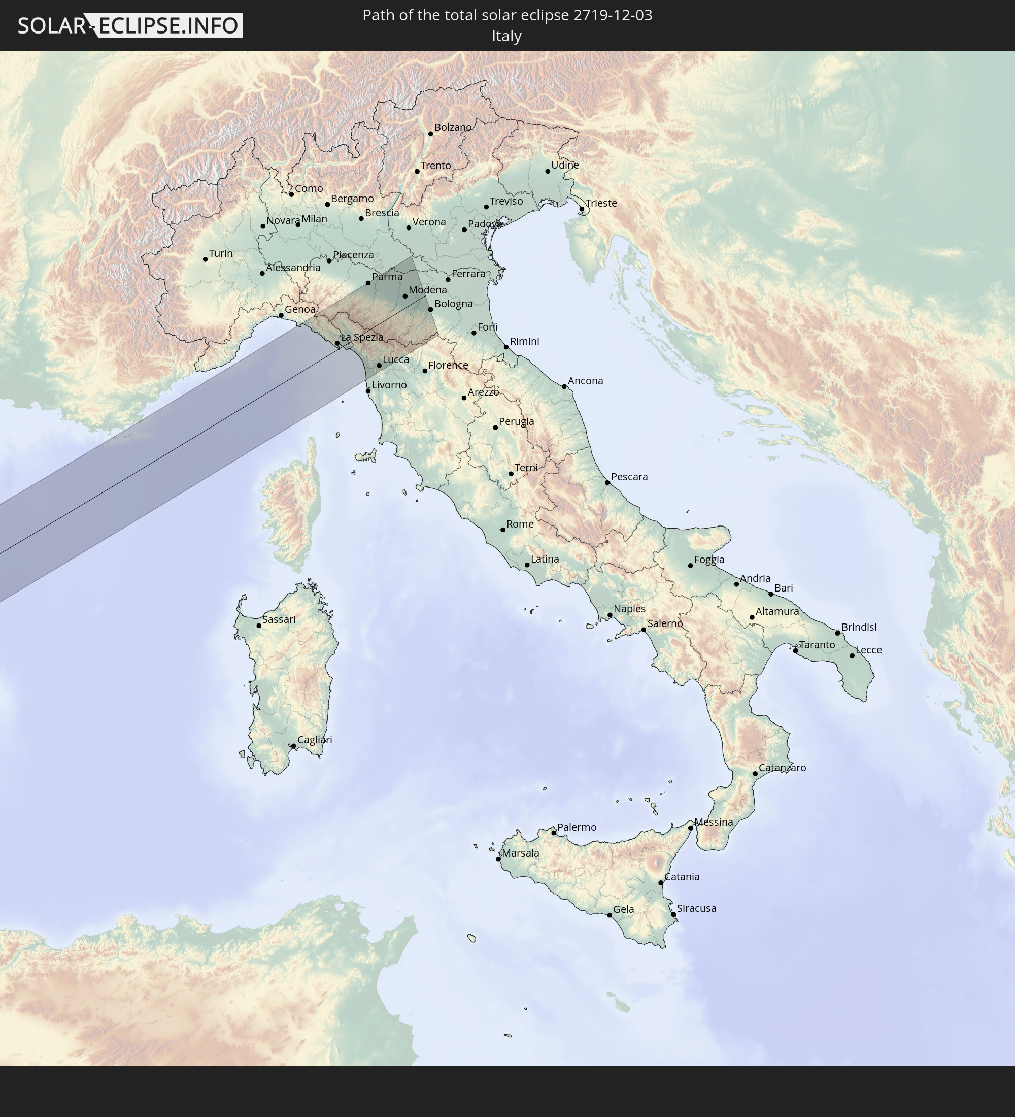 Italy
Italy
In den folgenden Ländern ist die Sonnenfinsternis partiell zu sehen
 United States
 United States Minor Outlying Islands
 Canada
 Mexico
 Greenland
 Guatemala
 El Salvador
 Honduras
 Belize
 Nicaragua
 Costa Rica
 Cuba
Cuba
 Panama
 Colombia
 Cayman Islands
 The Bahamas
 Jamaica
 Haiti
Haiti
 Brazil
 Venezuela
 Turks and Caicos Islands
 Dominican Republic
 Aruba
Aruba
 Puerto Rico
 United States Virgin Islands
 Bermuda
 British Virgin Islands
 Anguilla
 Collectivity of Saint Martin
 Saint Barthélemy
 Saint Kitts and Nevis
 Antigua and Barbuda
 Montserrat
 Trinidad and Tobago
 Guadeloupe
 Grenada
 Dominica
 Saint Vincent and the Grenadines
 Guyana
 Martinique
 Saint Lucia
 Barbados
 Suriname
 Saint Pierre and Miquelon
 French Guiana
 Portugal
 Cabo Verde
 Iceland
 Spain
Spain
 Senegal
 Mauritania
 The Gambia
 Guinea-Bissau
 Guinea
 Sierra Leone
 Morocco
 Mali
Mali
 Liberia
 Republic of Ireland
 Algeria
 United Kingdom
 Ivory Coast
 Faroe Islands
 Burkina Faso
 Gibraltar
 France
 Isle of Man
 Ghana
Ghana
 Guernsey
 Jersey
 Togo
Togo
 Niger
Niger
 Benin
Benin
 Andorra
 Belgium
 Nigeria
 Netherlands
 Luxembourg
 Germany
 Switzerland
 Italy
Italy
 Monaco
 Tunisia
 Cameroon
 Libya
Libya
 Liechtenstein
 Austria
 Vatican City
 Chad
Chad
 Malta
Malta
 Central African Republic
 Sudan
Sudan
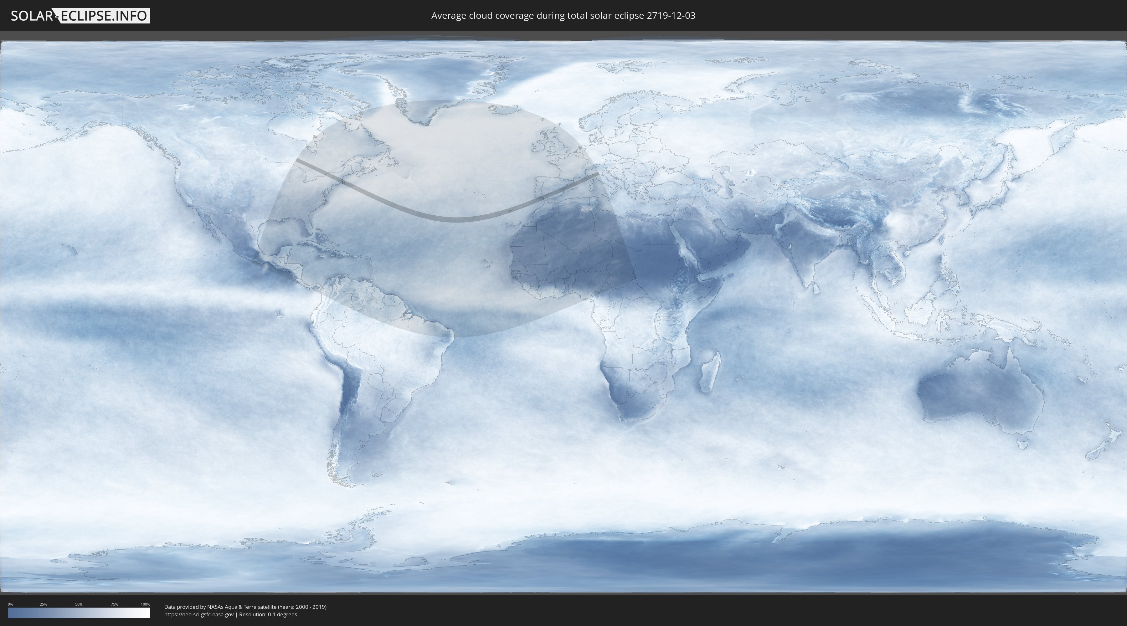
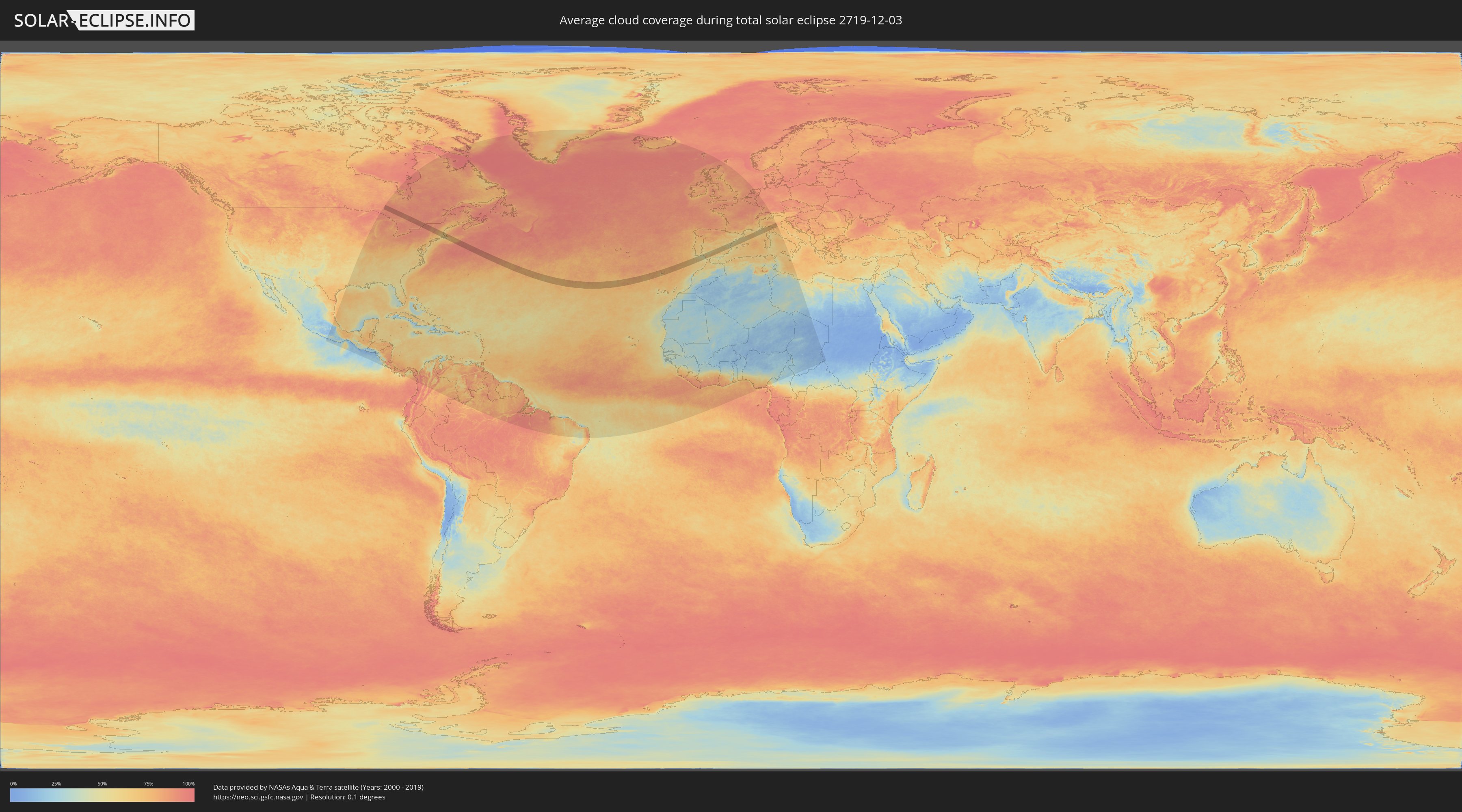
How will be the weather during the total solar eclipse on 12/03/2719?
Where is the best place to see the total solar eclipse of 12/03/2719?
The following maps show the average cloud coverage for the day of the total solar eclipse.
With the help of these maps, it is possible to find the place along the eclipse path, which has the best
chance of a cloudless sky.
Nevertheless, you should consider local circumstances and inform about the weather of your chosen
observation site.
The data is provided by NASAs satellites
AQUA and TERRA.
The cloud maps are averaged over a period of 19 years (2000 - 2019).
Detailed country maps
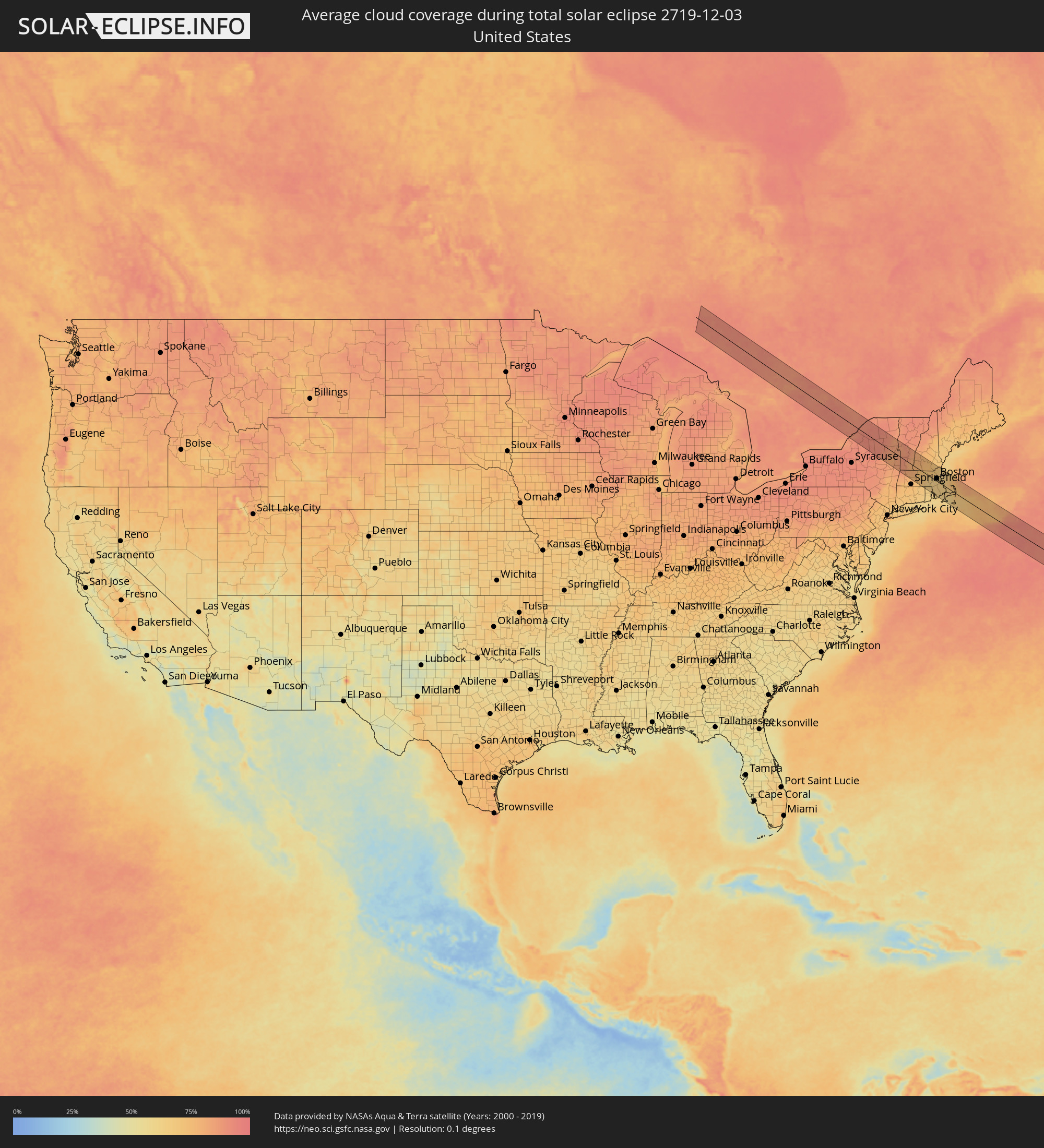 United States
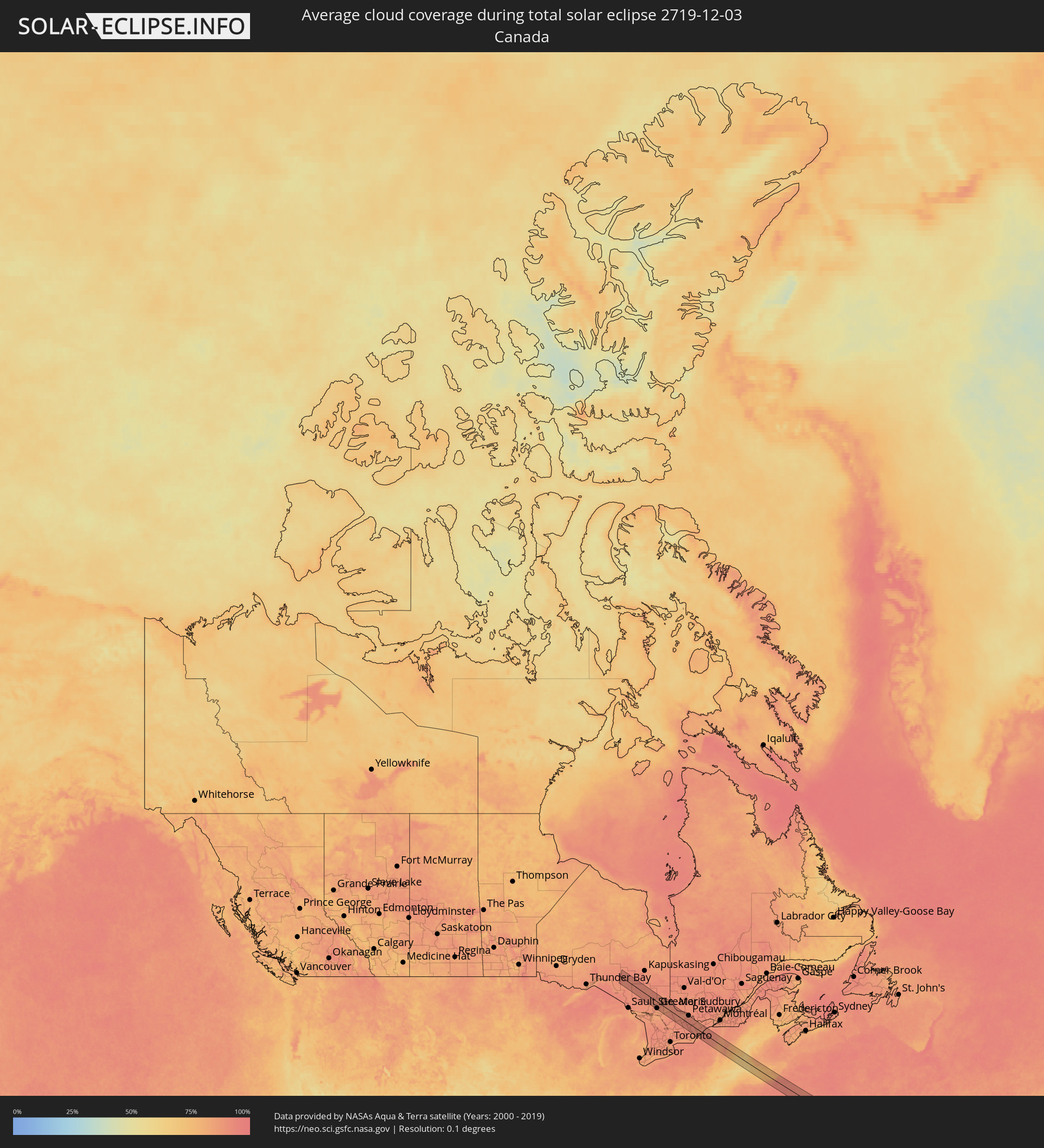 Canada
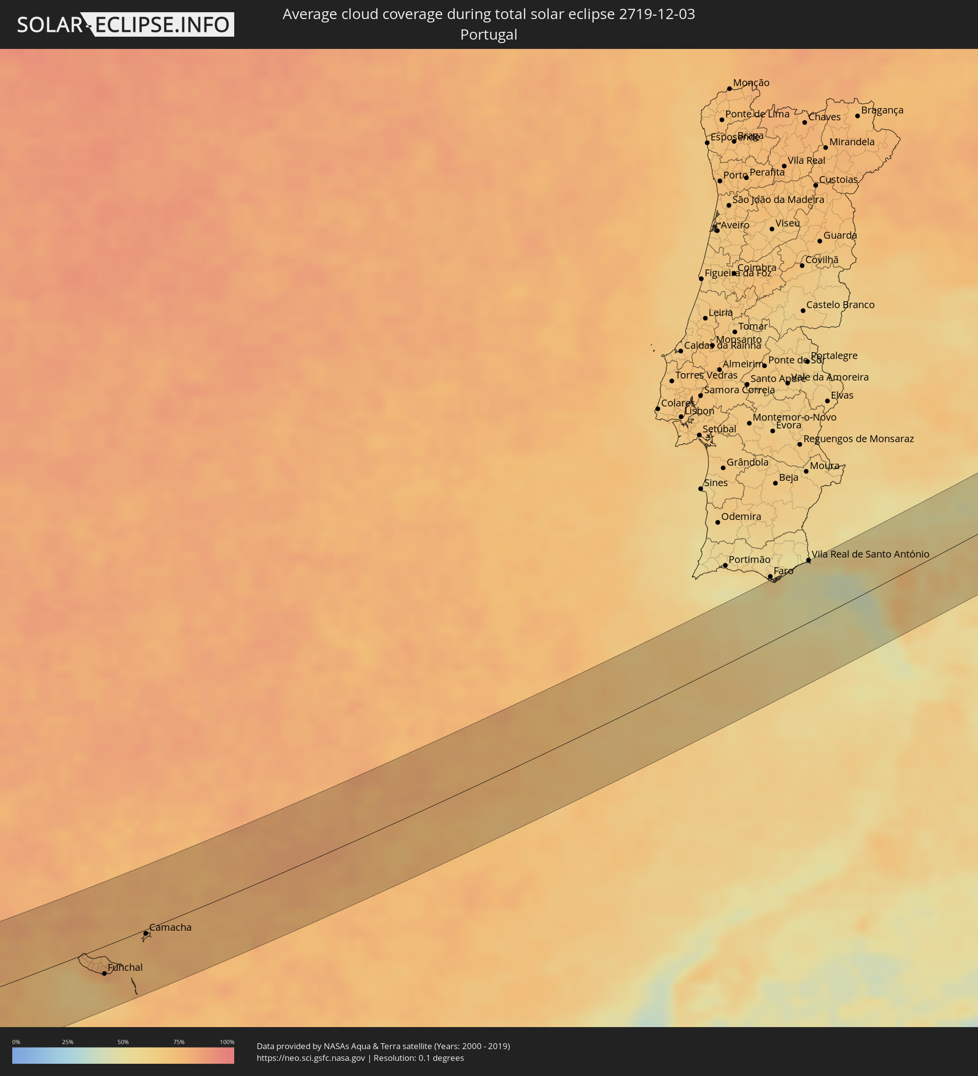 Portugal
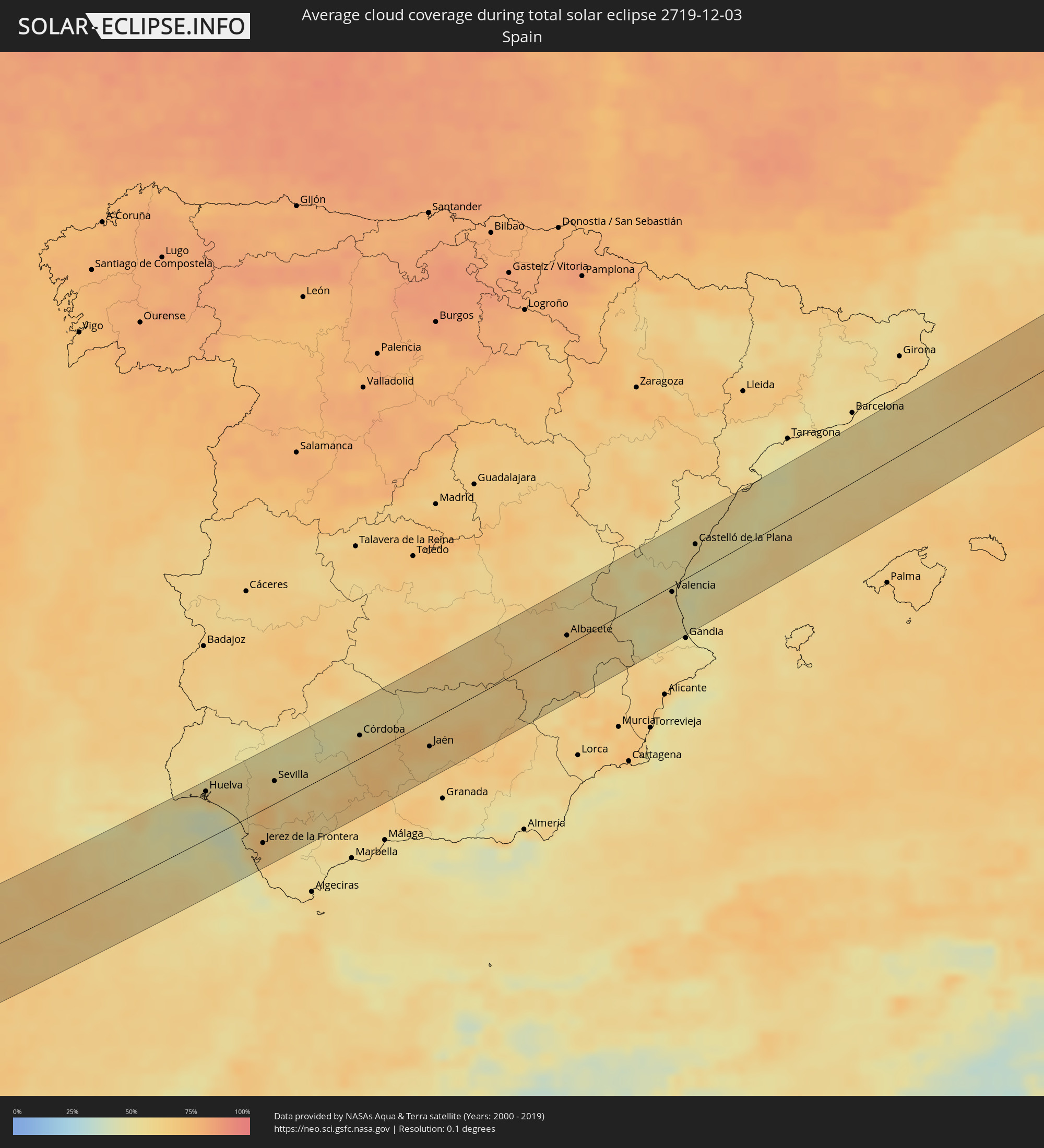 Spain
Spain
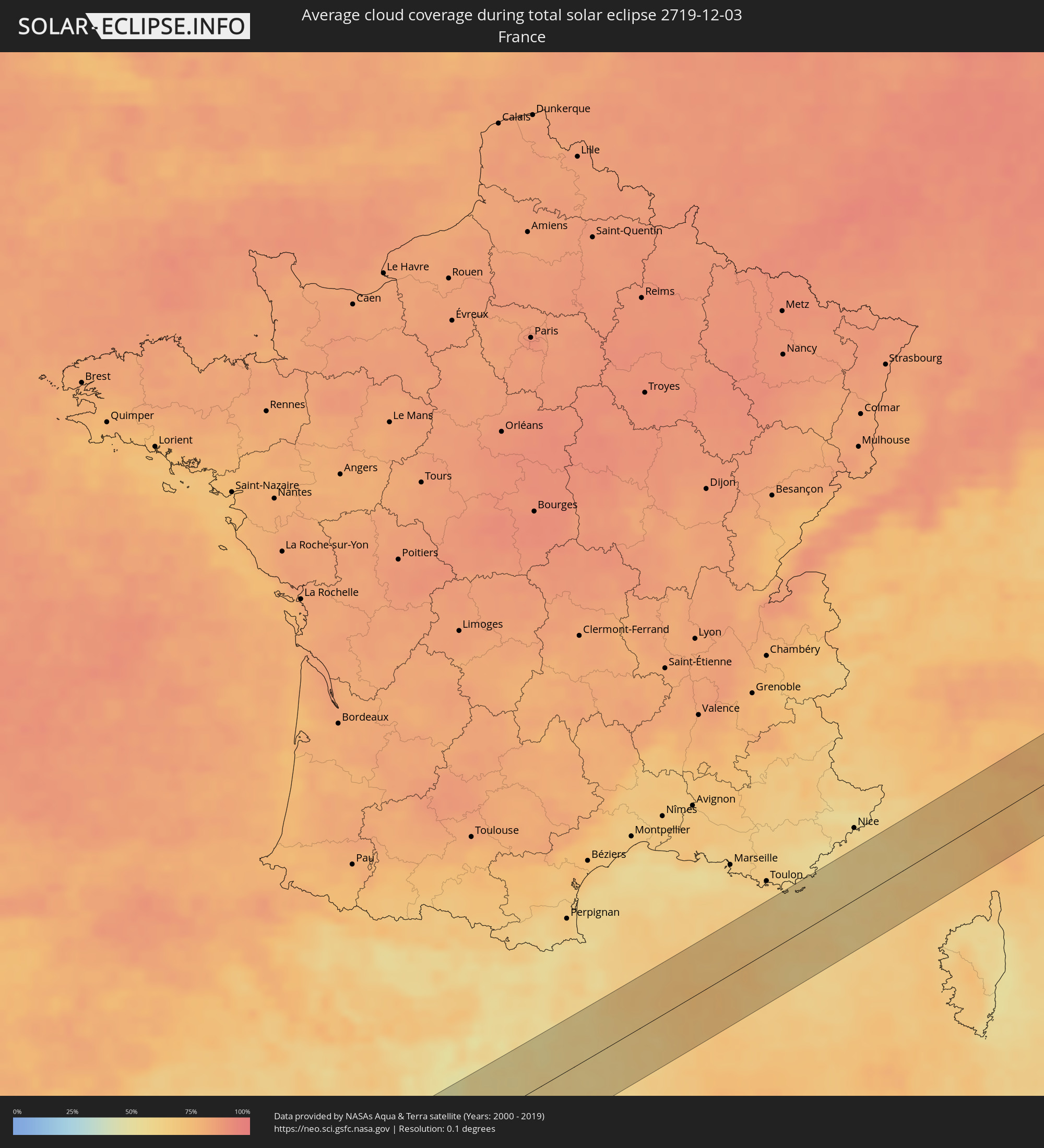 France
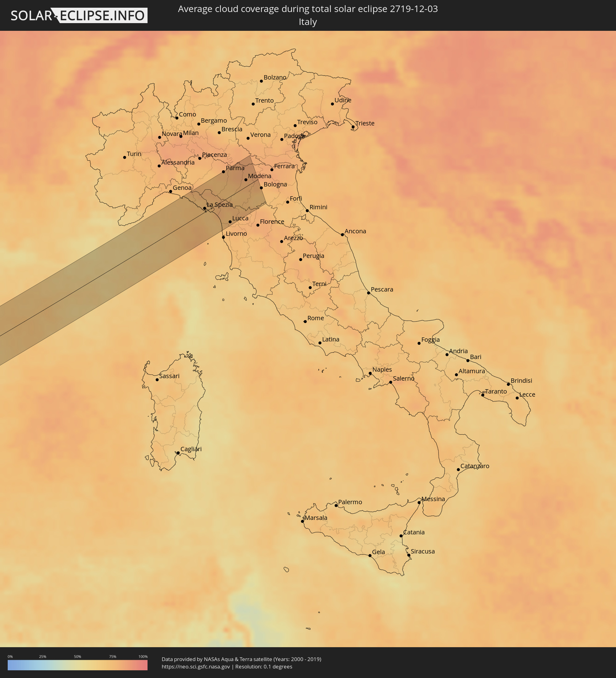 Italy
Italy
Cities inside the path of the eclipse
The following table shows all locations with a population of more than 5,000 inside the eclipse path. Cities which have more than 100,000 inhabitants are marked bold. A click at the locations opens a detailed map.
| City | Type | Eclipse duration | Local time of max. eclipse | Distance to central line | Ø Cloud coverage |
|
Rayside-Balfour, Ontario
|
total | - | 08:20:36 UTC-05:00 | 47 km | 88% |
|
Greater Sudbury, Ontario
|
total | - | 08:20:37 UTC-05:00 | 48 km | 85% |
|
North Bay, Ontario
|
total | - | 08:21:31 UTC-05:00 | 2 km | 86% |
|
Renfrew, Ontario
|
total | - | 08:22:49 UTC-05:00 | 46 km | 90% |
|
Arnprior, Ontario
|
total | - | 08:23:03 UTC-05:00 | 58 km | 87% |
|
Perth, Ontario
|
total | - | 08:22:35 UTC-05:00 | 13 km | 89% |
|
Gananoque, Ontario
|
total | - | 08:22:04 UTC-05:00 | 36 km | 87% |
|
Carleton Place, Ontario
|
total | - | 08:22:55 UTC-05:00 | 39 km | 89% |
|
Smiths Falls, Ontario
|
total | - | 08:22:47 UTC-05:00 | 23 km | 90% |
|
Watertown, New York
|
total | - | 08:21:56 UTC-05:00 | 57 km | 91% |
|
Brockville, Ontario
|
total | - | 08:22:45 UTC-05:00 | 9 km | 90% |
|
Saratoga Springs, New York
|
total | - | 08:23:01 UTC-05:00 | 45 km | 82% |
|
Glens Falls, New York
|
total | - | 08:23:22 UTC-05:00 | 18 km | 81% |
|
North Adams, Massachusetts
|
total | - | 08:23:19 UTC-05:00 | 50 km | 85% |
|
Rutland, Vermont
|
total | - | 08:24:19 UTC-05:00 | 40 km | 85% |
|
Greenfield, Massachusetts
|
total | - | 08:23:43 UTC-05:00 | 38 km | 78% |
|
Amherst Center, Massachusetts
|
total | - | 08:23:36 UTC-05:00 | 54 km | 77% |
|
Claremont, New Hampshire
|
total | - | 08:24:43 UTC-05:00 | 47 km | 81% |
|
Keene, New Hampshire
|
total | - | 08:24:22 UTC-05:00 | 9 km | 79% |
|
Southbridge, Massachusetts
|
total | - | 08:23:50 UTC-05:00 | 60 km | 68% |
|
Gardner, Massachusetts
|
total | - | 08:24:20 UTC-05:00 | 12 km | 71% |
|
Worcester, Massachusetts
|
total | - | 08:24:14 UTC-05:00 | 32 km | 69% |
|
Leominster, Massachusetts
|
total | - | 08:24:32 UTC-05:00 | 6 km | 68% |
|
Hudson, Massachusetts
|
total | - | 08:24:36 UTC-05:00 | 9 km | 68% |
|
Milford, Massachusetts
|
total | - | 08:24:26 UTC-05:00 | 31 km | 65% |
|
Woonsocket, Rhode Island
|
total | - | 08:24:18 UTC-05:00 | 43 km | 64% |
|
Nashua, New Hampshire
|
total | - | 08:25:03 UTC-05:00 | 30 km | 73% |
|
Manchester, New Hampshire
|
total | - | 08:25:17 UTC-05:00 | 52 km | 74% |
|
Acton, Massachusetts
|
total | - | 08:24:50 UTC-05:00 | 5 km | 67% |
|
Framingham, Massachusetts
|
total | - | 08:24:40 UTC-05:00 | 13 km | 64% |
|
Providence, Rhode Island
|
total | - | 08:24:15 UTC-05:00 | 55 km | 64% |
|
Lowell, Massachusetts
|
total | - | 08:25:06 UTC-05:00 | 24 km | 69% |
|
Derry Village, New Hampshire
|
total | - | 08:25:20 UTC-05:00 | 49 km | 72% |
|
Attleboro, Massachusetts
|
total | - | 08:24:30 UTC-05:00 | 38 km | 64% |
|
Needham, Massachusetts
|
total | - | 08:24:52 UTC-05:00 | 4 km | 63% |
|
Fall River, Massachusetts
|
total | - | 08:24:25 UTC-05:00 | 55 km | 62% |
|
Woburn, Massachusetts
|
total | - | 08:25:08 UTC-05:00 | 18 km | 66% |
|
Taunton, Massachusetts
|
total | - | 08:24:40 UTC-05:00 | 34 km | 63% |
|
Haverhill, Massachusetts
|
total | - | 08:25:29 UTC-05:00 | 48 km | 69% |
|
Boston, Massachusetts
|
total | - | 08:25:07 UTC-05:00 | 10 km | 65% |
|
Brockton, Massachusetts
|
total | - | 08:24:55 UTC-05:00 | 13 km | 64% |
|
Lynn, Massachusetts
|
total | - | 08:25:20 UTC-05:00 | 26 km | 64% |
|
Weymouth, Massachusetts
|
total | - | 08:25:07 UTC-05:00 | 3 km | 64% |
|
New Bedford, Massachusetts
|
total | - | 08:24:36 UTC-05:00 | 51 km | 63% |
|
Newburyport, Massachusetts
|
total | - | 08:25:44 UTC-05:00 | 61 km | 66% |
|
Hanover, Massachusetts
|
total | - | 08:25:10 UTC-05:00 | 1 km | 64% |
|
Gloucester, Massachusetts
|
total | - | 08:25:47 UTC-05:00 | 52 km | 65% |
|
Mashpee, Massachusetts
|
total | - | 08:25:07 UTC-05:00 | 29 km | 61% |
|
Barnstable, Massachusetts
|
total | - | 08:25:21 UTC-05:00 | 16 km | 63% |
|
Harwich, Massachusetts
|
total | - | 08:25:36 UTC-05:00 | 8 km | 66% |
|
Ribeira Brava, Madeira
|
total | - | 15:09:44 UTC+00:00 | 25 km | 75% |
|
São Vicente, Madeira
|
total | - | 15:09:41 UTC+00:00 | 11 km | 79% |
|
Câmara de Lobos, Madeira
|
total | - | 15:09:56 UTC+00:00 | 30 km | 65% |
|
Nossa Senhora do Monte, Madeira
|
total | - | 15:10:02 UTC+00:00 | 29 km | 79% |
|
Funchal, Madeira
|
total | - | 15:10:03 UTC+00:00 | 33 km | 69% |
|
Santana, Madeira
|
total | - | 15:09:58 UTC+00:00 | 16 km | 80% |
|
Caniço, Madeira
|
total | - | 15:10:09 UTC+00:00 | 34 km | 69% |
|
Camacha, Madeira
|
total | - | 15:10:08 UTC+00:00 | 30 km | 78% |
|
Santa Cruz, Madeira
|
total | - | 15:10:12 UTC+00:00 | 31 km | 78% |
|
Machico, Madeira
|
total | - | 15:10:15 UTC+00:00 | 30 km | 78% |
|
Camacha, Madeira
|
total | - | 15:10:45 UTC+00:00 | 5 km | 78% |
|
Vila Real de Santo António, Faro
|
total | - | 15:21:12 UTC+00:00 | 66 km | 51% |
|
Lepe, Andalusia
|
total | - | 16:21:26 UTC+01:00 | 63 km | 59% |
|
Huelva, Andalusia
|
total | - | 16:21:46 UTC+01:00 | 53 km | 63% |
|
Sanlúcar de Barrameda, Andalusia
|
total | - | 16:22:59 UTC+01:00 | 19 km | 56% |
|
Cadiz, Andalusia
|
total | - | 16:23:18 UTC+01:00 | 46 km | 48% |
|
Chiclana de la Frontera, Andalusia
|
total | - | 16:23:35 UTC+01:00 | 63 km | 58% |
|
Jerez de la Frontera, Andalusia
|
total | - | 16:23:21 UTC+01:00 | 37 km | 66% |
|
Lebrija, Andalusia
|
total | - | 16:23:12 UTC+01:00 | 17 km | 69% |
|
Sevilla, Andalusia
|
total | - | 16:22:53 UTC+01:00 | 25 km | 62% |
|
Arcos de la Frontera, Andalusia
|
total | - | 16:23:42 UTC+01:00 | 44 km | 63% |
|
Utrera, Andalusia
|
total | - | 16:23:19 UTC+01:00 | 3 km | 64% |
|
Carmona, Andalusia
|
total | - | 16:23:12 UTC+01:00 | 20 km | 57% |
|
Morón de la Frontera, Andalusia
|
total | - | 16:23:47 UTC+01:00 | 23 km | 67% |
|
Écija, Andalusia
|
total | - | 16:23:49 UTC+01:00 | 4 km | 63% |
|
Córdoba, Andalusia
|
total | - | 16:23:50 UTC+01:00 | 25 km | 64% |
|
Puente-Genil, Andalusia
|
total | - | 16:24:21 UTC+01:00 | 25 km | 66% |
|
Montilla, Andalusia
|
total | - | 16:24:18 UTC+01:00 | 11 km | 69% |
|
Lucena, Andalusia
|
total | - | 16:24:40 UTC+01:00 | 34 km | 73% |
|
Priego de Córdoba, Andalusia
|
total | - | 16:24:58 UTC+01:00 | 44 km | 66% |
|
Andújar, Andalusia
|
total | - | 16:24:32 UTC+01:00 | 9 km | 72% |
|
Martos, Andalusia
|
total | - | 16:24:57 UTC+01:00 | 25 km | 63% |
|
Alcalá la Real, Andalusia
|
total | - | 16:25:16 UTC+01:00 | 53 km | 65% |
|
Jaén, Andalusia
|
total | - | 16:25:07 UTC+01:00 | 28 km | 66% |
|
Linares, Andalusia
|
total | - | 16:24:57 UTC+01:00 | 3 km | 65% |
|
Valdepeñas, Castille-La Mancha
|
total | - | 16:24:34 UTC+01:00 | 52 km | 62% |
|
Úbeda, Andalusia
|
total | - | 16:25:20 UTC+01:00 | 22 km | 72% |
|
Campiña, Andalusia
|
total | - | 16:25:34 UTC+01:00 | 18 km | 65% |
|
Albacete, Castille-La Mancha
|
total | - | 16:25:59 UTC+01:00 | 10 km | 70% |
|
Hellín, Castille-La Mancha
|
total | - | 16:26:39 UTC+01:00 | 43 km | 67% |
|
Yecla, Murcia
|
total | - | 16:27:09 UTC+01:00 | 58 km | 60% |
|
Almansa, Castille-La Mancha
|
total | - | 16:26:54 UTC+01:00 | 34 km | 65% |
|
Ontinyent, Valencia
|
total | - | 16:27:27 UTC+01:00 | 59 km | 58% |
|
Llíria, Valencia
|
total | - | 16:26:36 UTC+01:00 | 19 km | 58% |
|
Xàtiva, Valencia
|
total | - | 16:27:21 UTC+01:00 | 47 km | 59% |
|
Alzira, Valencia
|
total | - | 16:27:16 UTC+01:00 | 35 km | 55% |
|
Valencia, Valencia
|
total | - | 16:26:59 UTC+01:00 | 6 km | 61% |
|
Sagunto, Valencia
|
total | - | 16:26:52 UTC+01:00 | 10 km | 54% |
|
Onda, Valencia
|
total | - | 16:26:34 UTC+01:00 | 37 km | 50% |
|
Cullera, Valencia
|
total | - | 16:27:26 UTC+01:00 | 41 km | 54% |
|
Castelló de la Plana, Valencia
|
total | - | 16:26:45 UTC+01:00 | 30 km | 56% |
|
Vinaròs, Valencia
|
total | - | 16:26:43 UTC+01:00 | 54 km | 56% |
|
Chiavari, Liguria
|
total | - | 16:29:02 UTC+01:00 | 48 km | 72% |
|
La Spezia, Liguria
|
total | - | 16:29:36 UTC+01:00 | 6 km | 71% |
|
Santo Stefano di Magra, Liguria
|
total | - | 16:29:37 UTC+01:00 | 6 km | 71% |
|
Colombiera-Molicciara, Liguria
|
total | - | 16:29:44 UTC+01:00 | 3 km | 71% |
|
Casano-Dogana-Isola, Liguria
|
total | - | 16:29:46 UTC+01:00 | 5 km | 71% |
|
Massa, Tuscany
|
total | - | 16:29:53 UTC+01:00 | 13 km | 72% |
|
Forte dei Marmi, Tuscany
|
total | - | 16:29:59 UTC+01:00 | 22 km | 74% |
|
Collecchio, Emilia-Romagna
|
total | - | 16:29:02 UTC+01:00 | 51 km | 76% |
|
Viareggio, Tuscany
|
total | - | 16:30:09 UTC+01:00 | 34 km | 73% |
|
Parma, Emilia-Romagna
|
total | - | 16:29:02 UTC+01:00 | 51 km | 76% |
|
Vecchiano-Nodica, Tuscany
|
total | - | 16:30:20 UTC+01:00 | 48 km | 75% |
|
Castelnovo ne'Monti, Emilia-Romagna
|
total | - | 16:29:32 UTC+01:00 | 13 km | 72% |
|
Pontasserchio, Tuscany
|
total | - | 16:30:21 UTC+01:00 | 49 km | 75% |
|
Sorbolo, Emilia-Romagna
|
total | - | 16:29:03 UTC+01:00 | 51 km | 77% |
|
Sant'Ilario d'Enza, Emilia-Romagna
|
total | - | 16:29:09 UTC+01:00 | 42 km | 77% |
|
Lucca, Tuscany
|
total | - | 16:30:20 UTC+01:00 | 47 km | 75% |
|
Castelnovo di Sotto, Emilia-Romagna
|
total | - | 16:29:09 UTC+01:00 | 42 km | 79% |
|
Cadelbosco di Sopra, Emilia-Romagna
|
total | - | 16:29:14 UTC+01:00 | 37 km | 79% |
|
Porcari, Tuscany
|
total | - | 16:30:24 UTC+01:00 | 52 km | 77% |
|
Reggio nell'Emilia, Emilia-Romagna
|
total | - | 16:29:20 UTC+01:00 | 29 km | 76% |
|
Bagnolo in Piano, Emilia-Romagna
|
total | - | 16:29:17 UTC+01:00 | 35 km | 80% |
|
Pescia, Tuscany
|
total | - | 16:30:23 UTC+01:00 | 50 km | 76% |
|
Casalgrande, Emilia-Romagna
|
total | - | 16:29:32 UTC+01:00 | 14 km | 75% |
|
Suzzara, Lombardy
|
total | - | 16:29:02 UTC+01:00 | 52 km | 79% |
|
Sassuolo, Emilia-Romagna
|
total | - | 16:29:37 UTC+01:00 | 8 km | 74% |
|
Fabbrico, Emilia-Romagna
|
total | - | 16:29:13 UTC+01:00 | 38 km | 80% |
|
Reggiolo, Emilia-Romagna
|
total | - | 16:29:10 UTC+01:00 | 42 km | 80% |
|
Pavullo nel Frignano, Emilia-Romagna
|
total | - | 16:29:55 UTC+01:00 | 14 km | 74% |
|
Campogalliano, Emilia-Romagna
|
total | - | 16:29:28 UTC+01:00 | 19 km | 78% |
|
Carpi Centro, Emilia-Romagna
|
total | - | 16:29:22 UTC+01:00 | 27 km | 79% |
|
Modena, Emilia-Romagna
|
total | - | 16:29:34 UTC+01:00 | 12 km | 76% |
|
Castelnuovo Rangone, Emilia-Romagna
|
total | - | 16:29:42 UTC+01:00 | 5 km | 74% |
|
Vignola, Emilia-Romagna
|
total | - | 16:29:49 UTC+01:00 | 8 km | 74% |
|
Mirandola, Emilia-Romagna
|
total | - | 16:29:21 UTC+01:00 | 28 km | 80% |
|
Bazzano, Emilia-Romagna
|
total | - | 16:29:50 UTC+01:00 | 9 km | 74% |
|
San Felice sul Panaro, Emilia-Romagna
|
total | - | 16:29:27 UTC+01:00 | 21 km | 80% |
|
San Giovanni in Persiceto, Emilia-Romagna
|
total | - | 16:29:43 UTC+01:00 | 0 km | 78% |
|
Sasso Marconi, Emilia-Romagna
|
total | - | 16:30:03 UTC+01:00 | 25 km | 71% |
|
Calderara di Reno, Emilia-Romagna
|
total | - | 16:29:52 UTC+01:00 | 11 km | 76% |
|
Casalecchio di Reno, Emilia-Romagna
|
total | - | 16:29:59 UTC+01:00 | 19 km | 73% |