Totale Sonnenfinsternis vom 15.03.-0143
| Wochentag: | Freitag |
| Maximale Dauer der Verfinsterung: | 05m45s |
| Maximale Breite des Finsternispfades: | 216 km |
| Saroszyklus: | 66 |
| Bedeckungsgrad: | 100% |
| Magnitude: | 1.065 |
| Gamma: | -0.172 |
Wo kann man die Sonnenfinsternis vom 15.03.-0143 sehen?
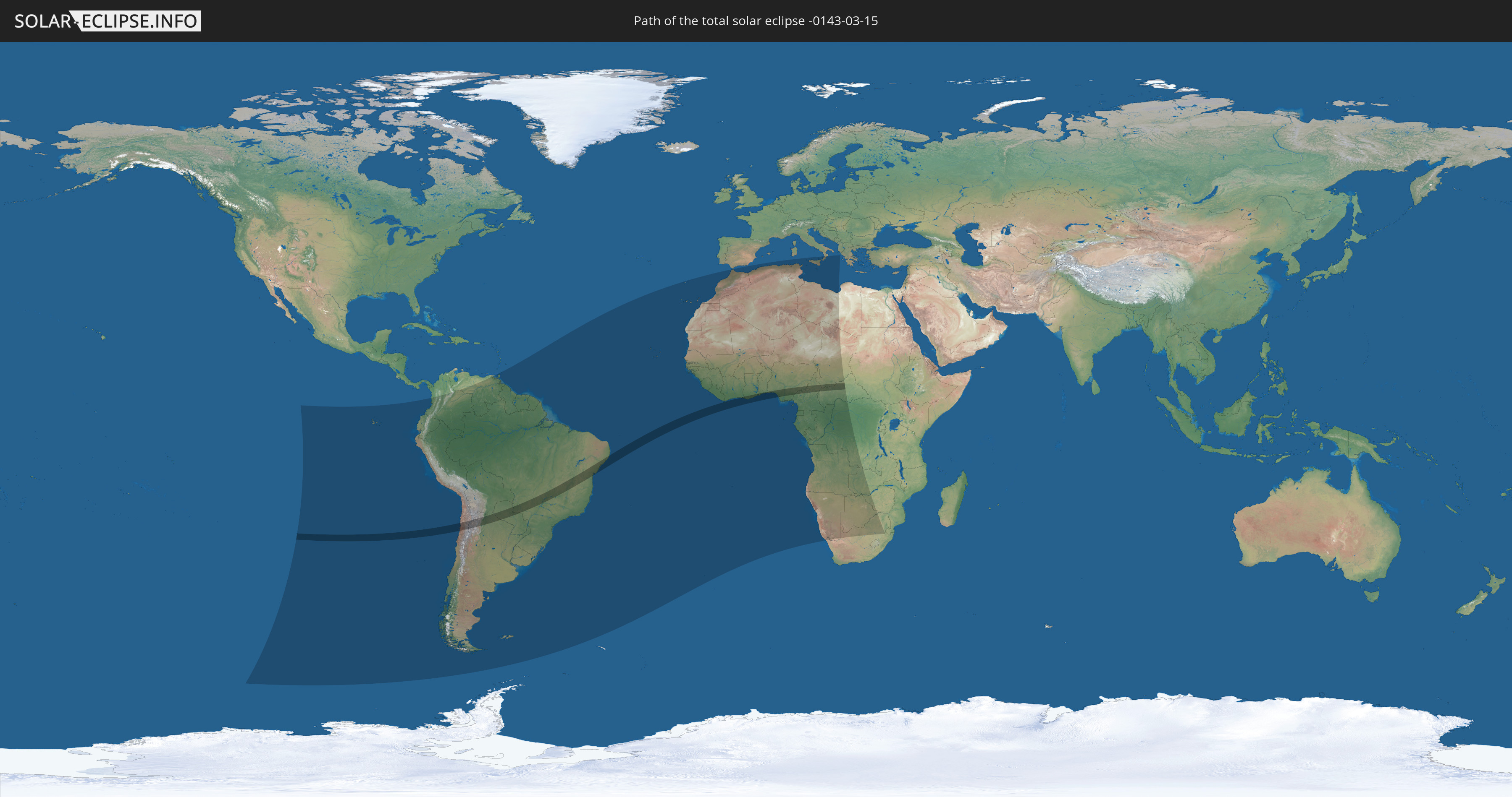
Die Sonnenfinsternis am 15.03.-0143 kann man in 54 Ländern als partielle Sonnenfinsternis beobachten.
Der Finsternispfad verläuft durch 12 Länder. Nur in diesen Ländern ist sie als totale Sonnenfinsternis zu sehen.
In den folgenden Ländern ist die Sonnenfinsternis total zu sehen
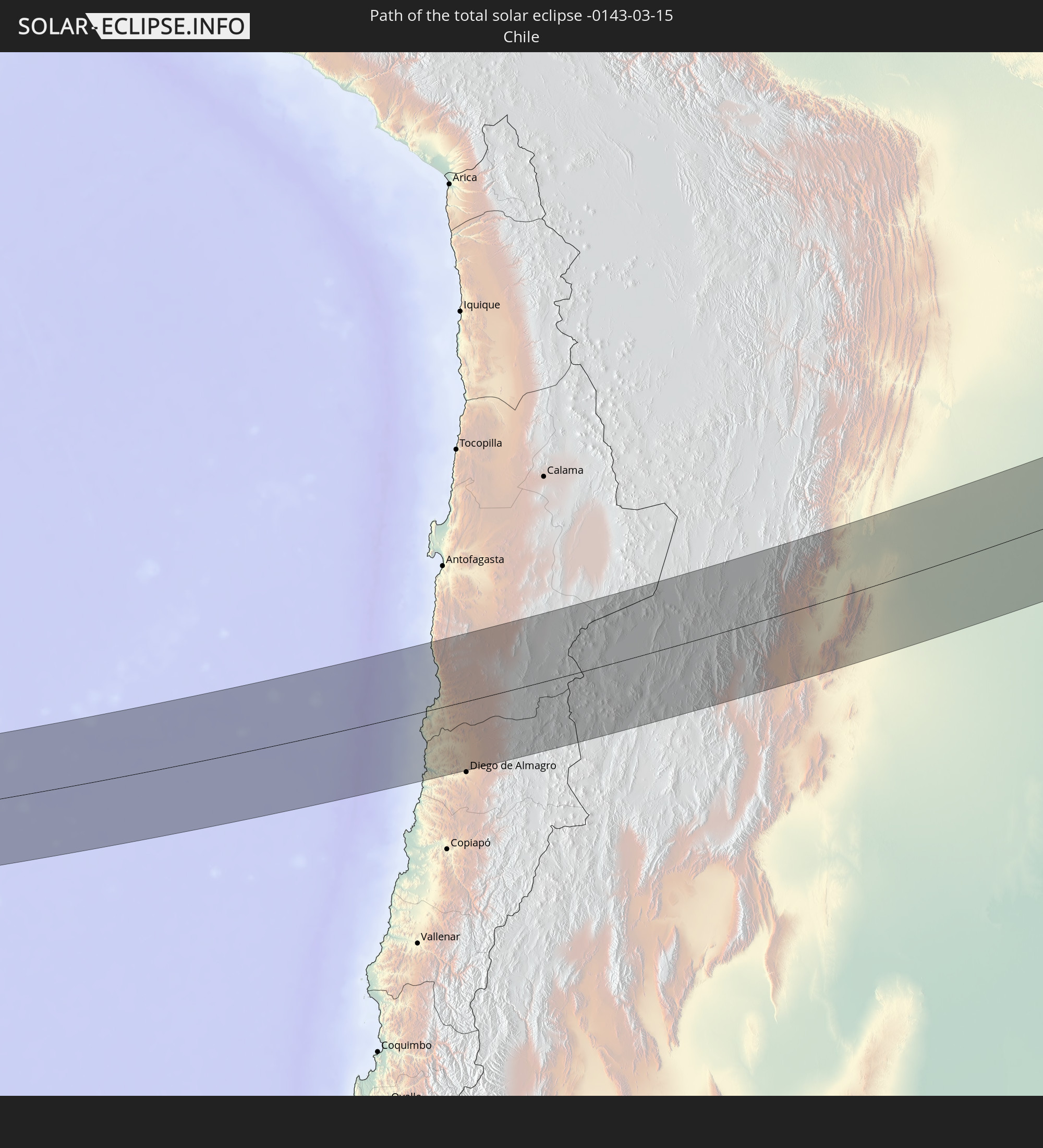 Chile
Chile
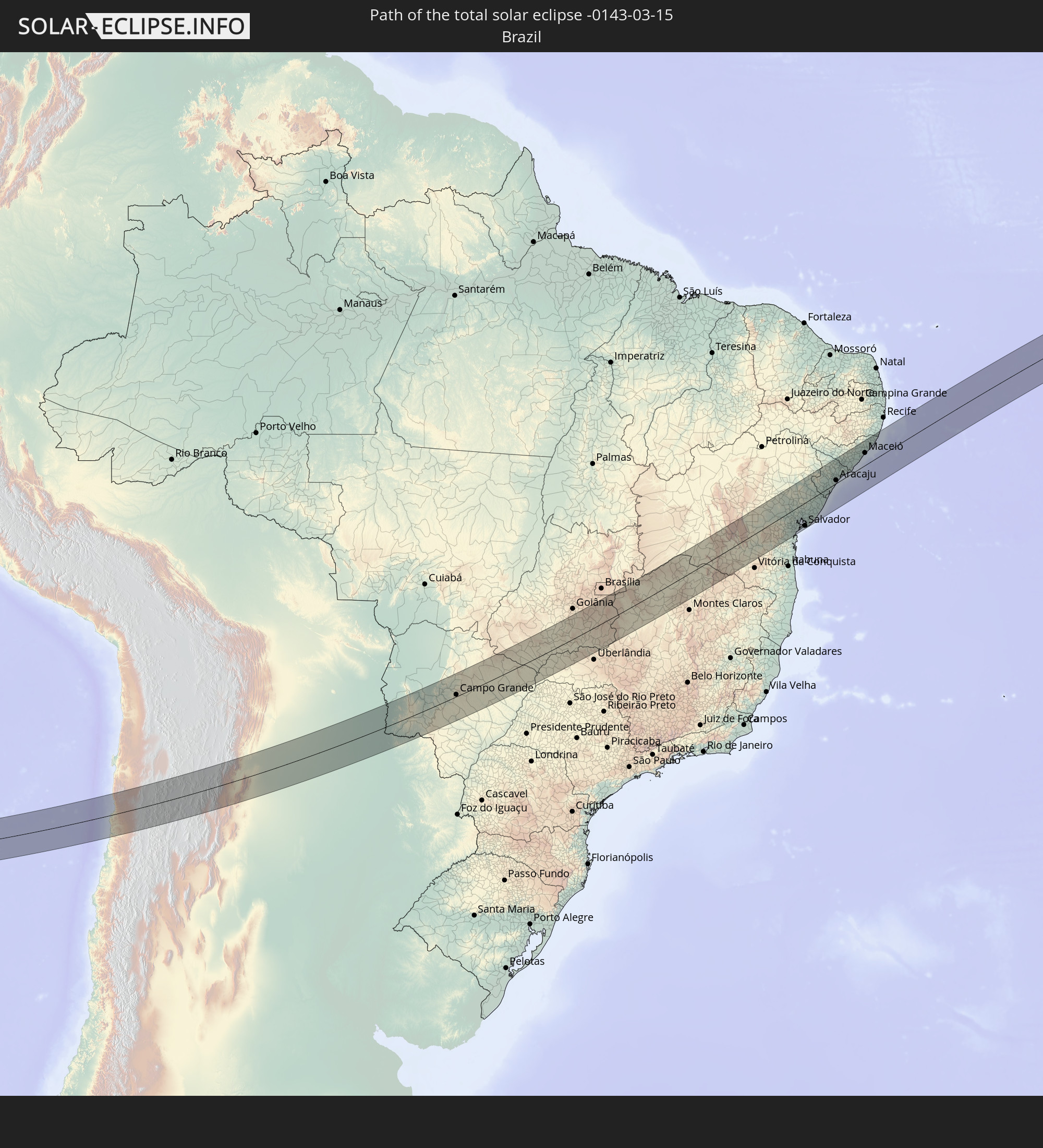 Brasilien
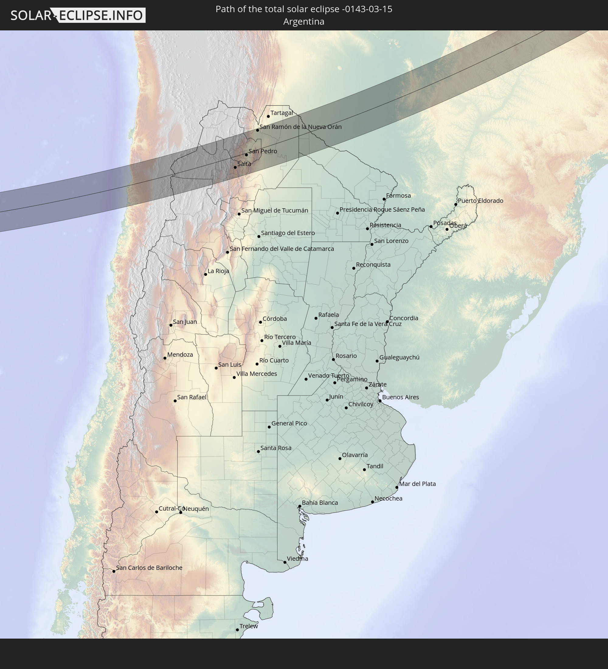 Argentinien
 Paraguay
 Elfenbeinküste
 Ghana
Ghana
 Togo
Togo
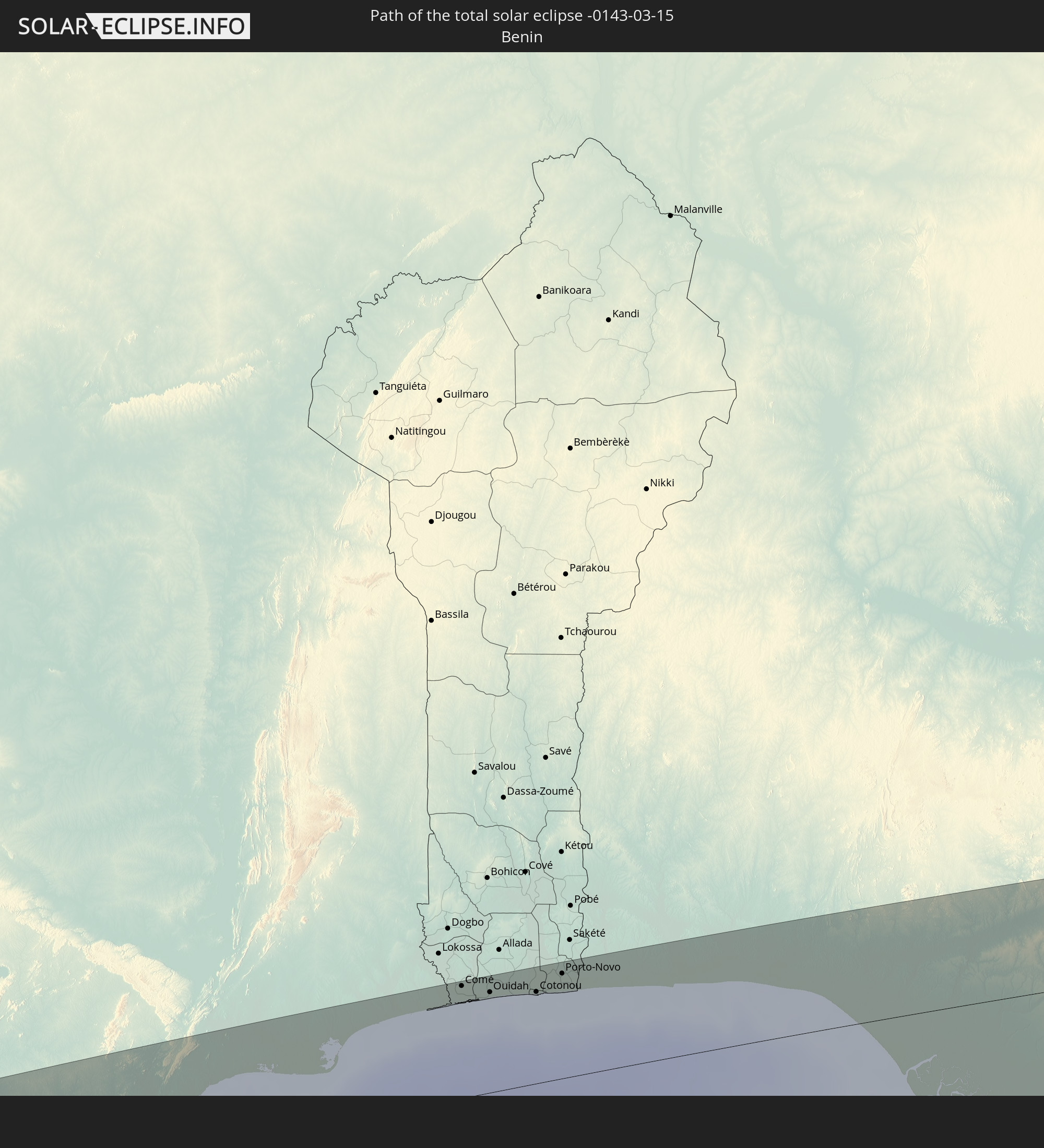 Benin
Benin
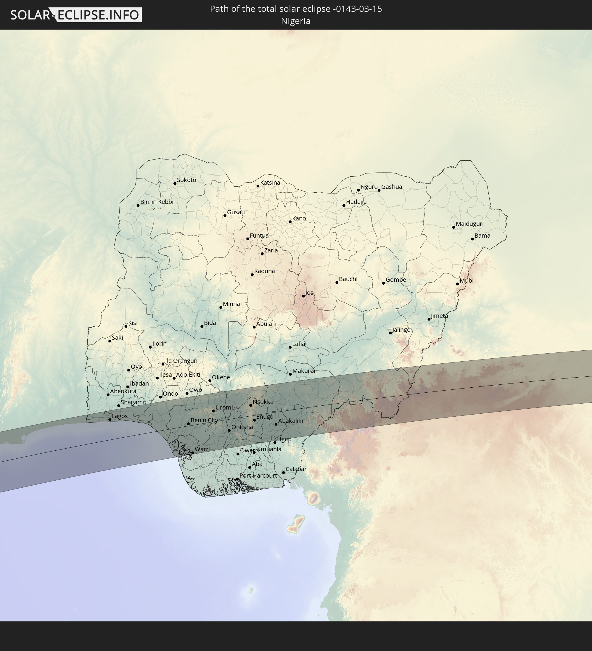 Nigeria
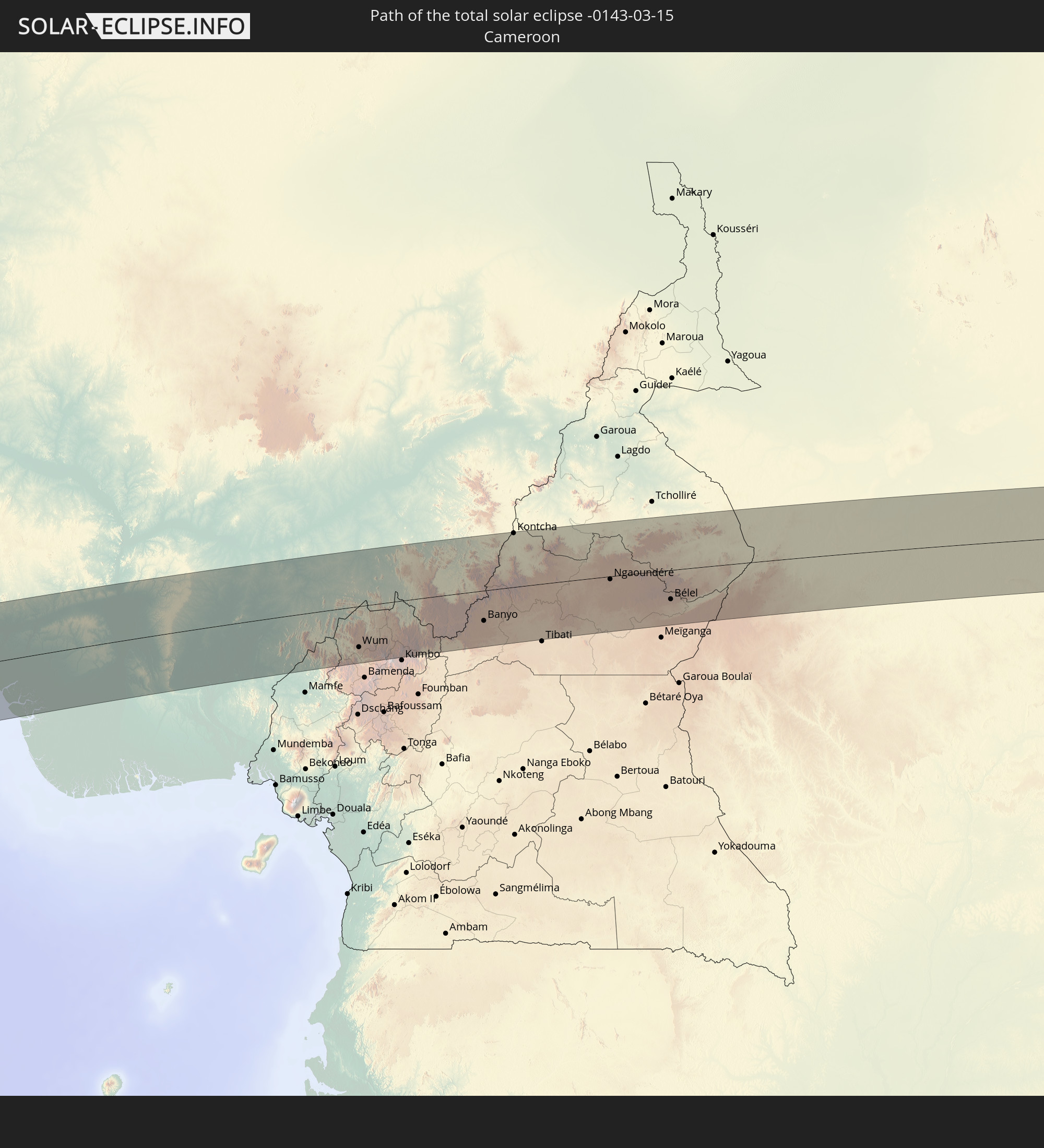 Kamerun
 Tschad
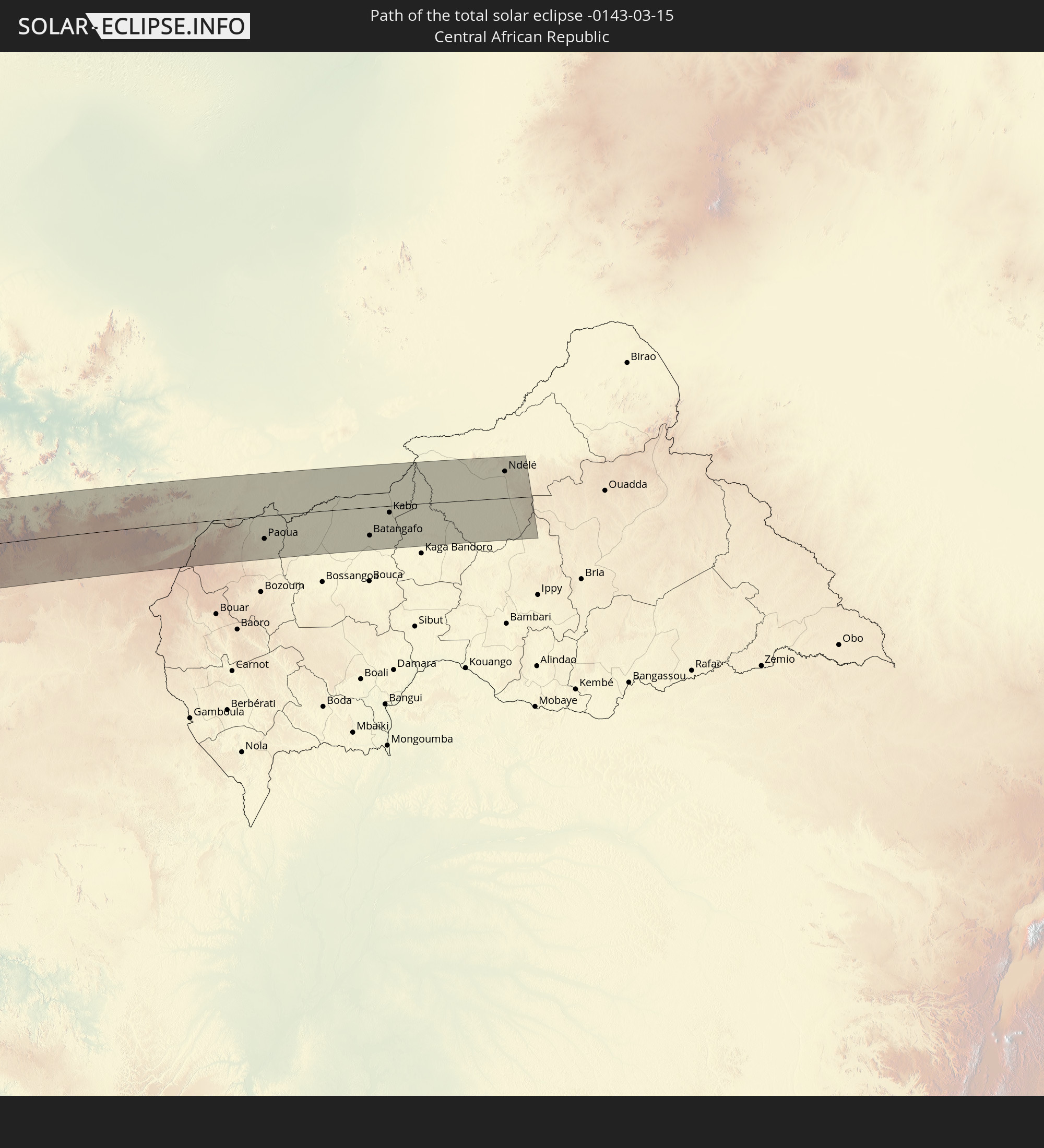 Zentralafrikanische Republik
In den folgenden Ländern ist die Sonnenfinsternis partiell zu sehen
 Chile
Chile
 Ecuador
 Kolumbien
 Peru
Peru
 Brasilien
 Argentinien
 Venezuela
 Bolivien
 Paraguay
 Trinidad und Tobago
 Falklandinseln
 Guyana
 Uruguay
 Suriname
 Französisch-Guayana
 Portugal
 Kap Verde
 Spanien
 Senegal
 Mauretanien
 Gambia
 Guinea-Bissau
 Guinea
 St. Helena
 Sierra Leone
 Marokko
 Mali
Mali
 Liberia
 Algerien
 Elfenbeinküste
 Burkina Faso
 Ghana
Ghana
 Togo
Togo
 Niger
Niger
 Benin
Benin
 Nigeria
 Äquatorialguinea
 São Tomé und Príncipe
 Italien
 Tunesien
 Kamerun
 Gabun
Gabun
 Libyen
 Republik Kongo
 Angola
 Namibia
 Demokratische Republik Kongo
 Tschad
 Malta
Malta
 Zentralafrikanische Republik
 Südafrika
 Botswana
 Sambia
 Simbabwe
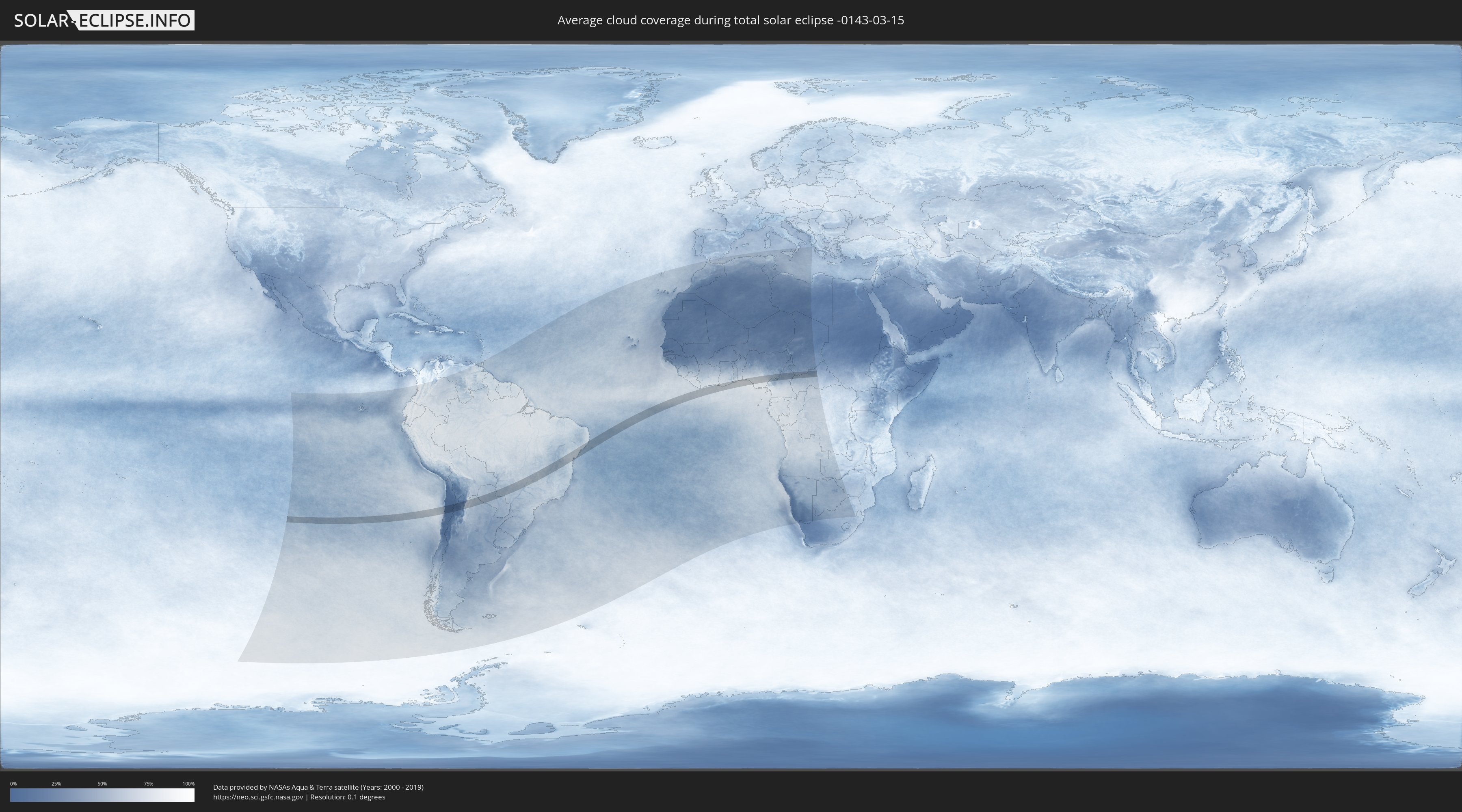
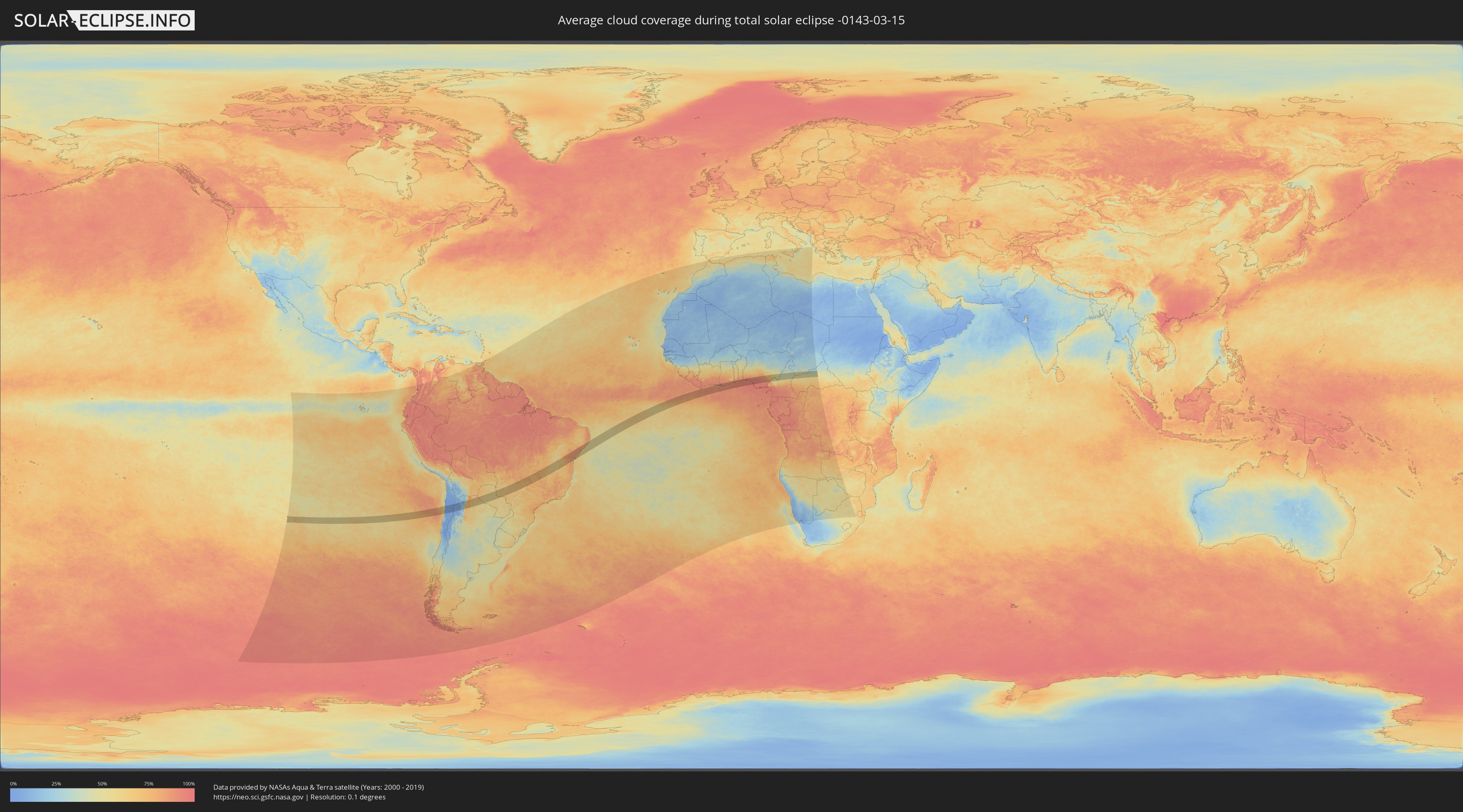
Wie wird das Wetter während der totalen Sonnenfinsternis am 15.03.-0143?
Wo ist der beste Ort, um die totale Sonnenfinsternis vom 15.03.-0143 zu beobachten?
Die folgenden Karten zeigen die durchschnittliche Bewölkung für den Tag, an dem die totale Sonnenfinsternis
stattfindet. Mit Hilfe der Karten lässt sich der Ort entlang des Finsternispfades eingrenzen,
der die besten Aussichen auf einen klaren wolkenfreien Himmel bietet.
Trotzdem muss man immer lokale Gegenenheiten beachten und sollte sich genau über das Wetter an seinem
gewählten Beobachtungsort informieren.
Die Daten stammen von den beiden NASA-Satelliten
AQUA und TERRA
und wurden über einen Zeitraum von 19 Jahren (2000 - 2019) gemittelt.
Detaillierte Länderkarten
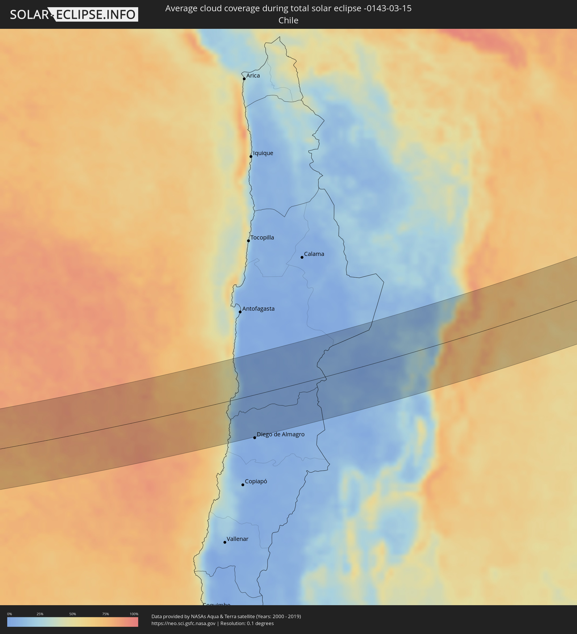 Chile
Chile
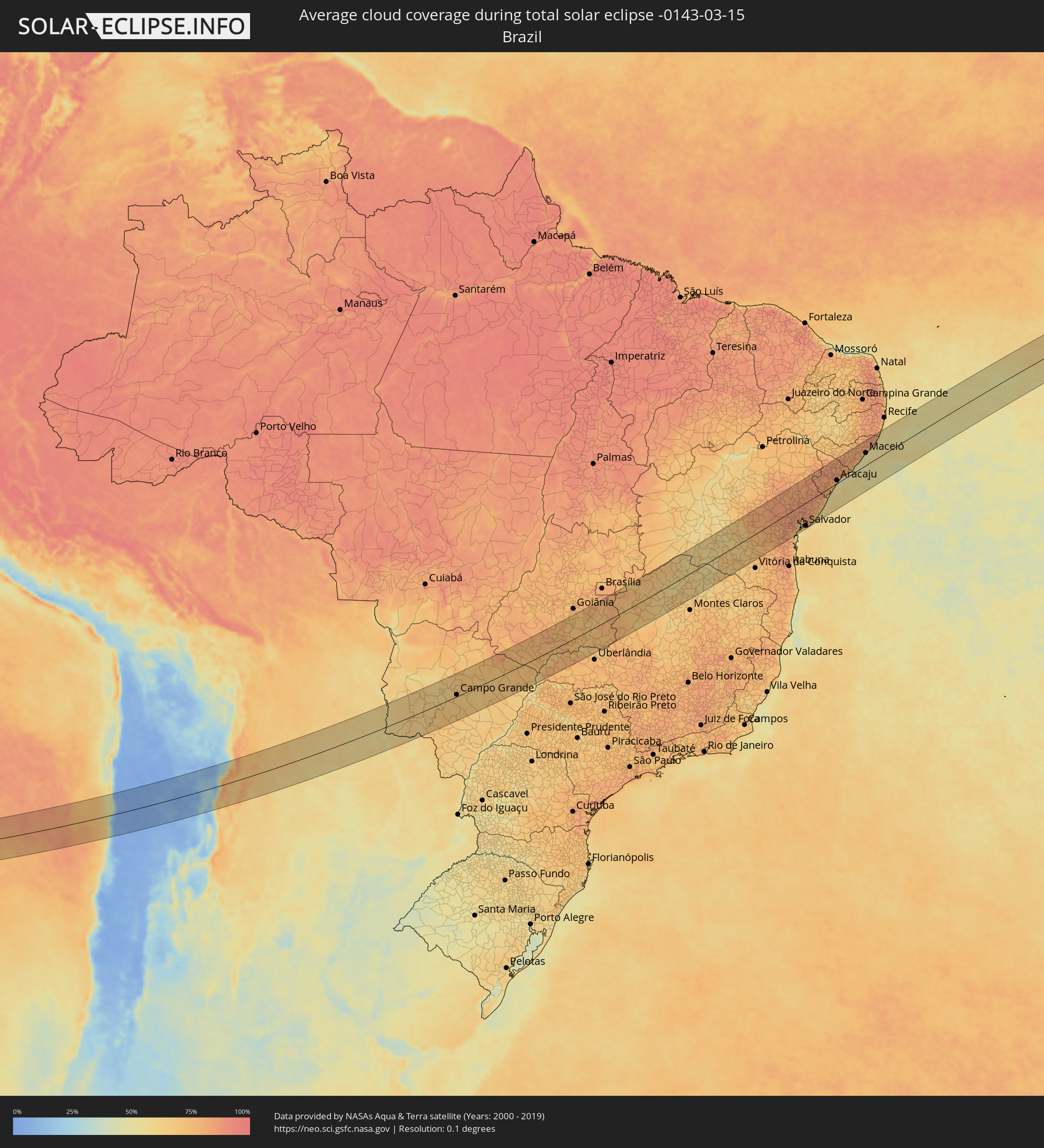 Brasilien
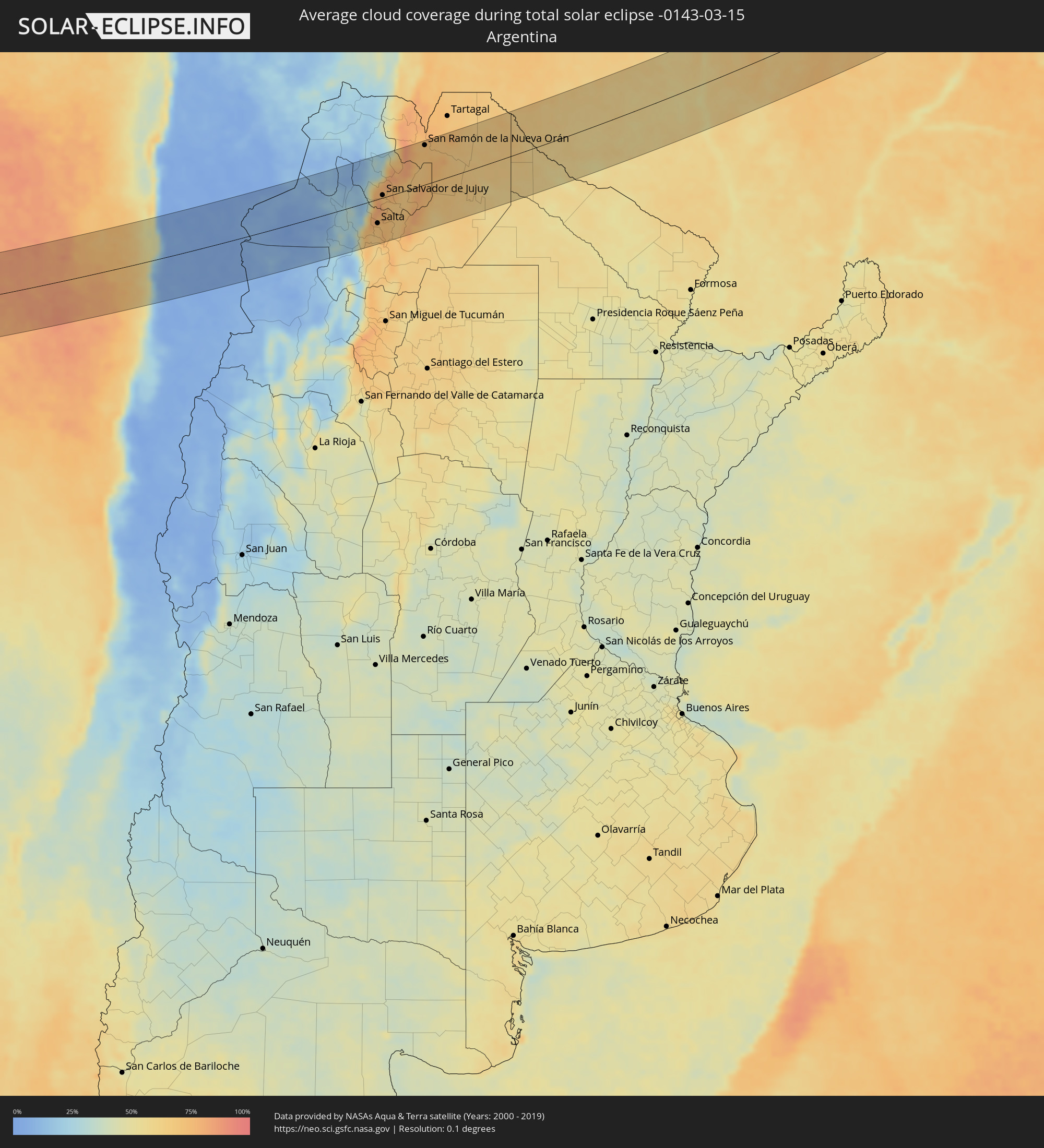 Argentinien
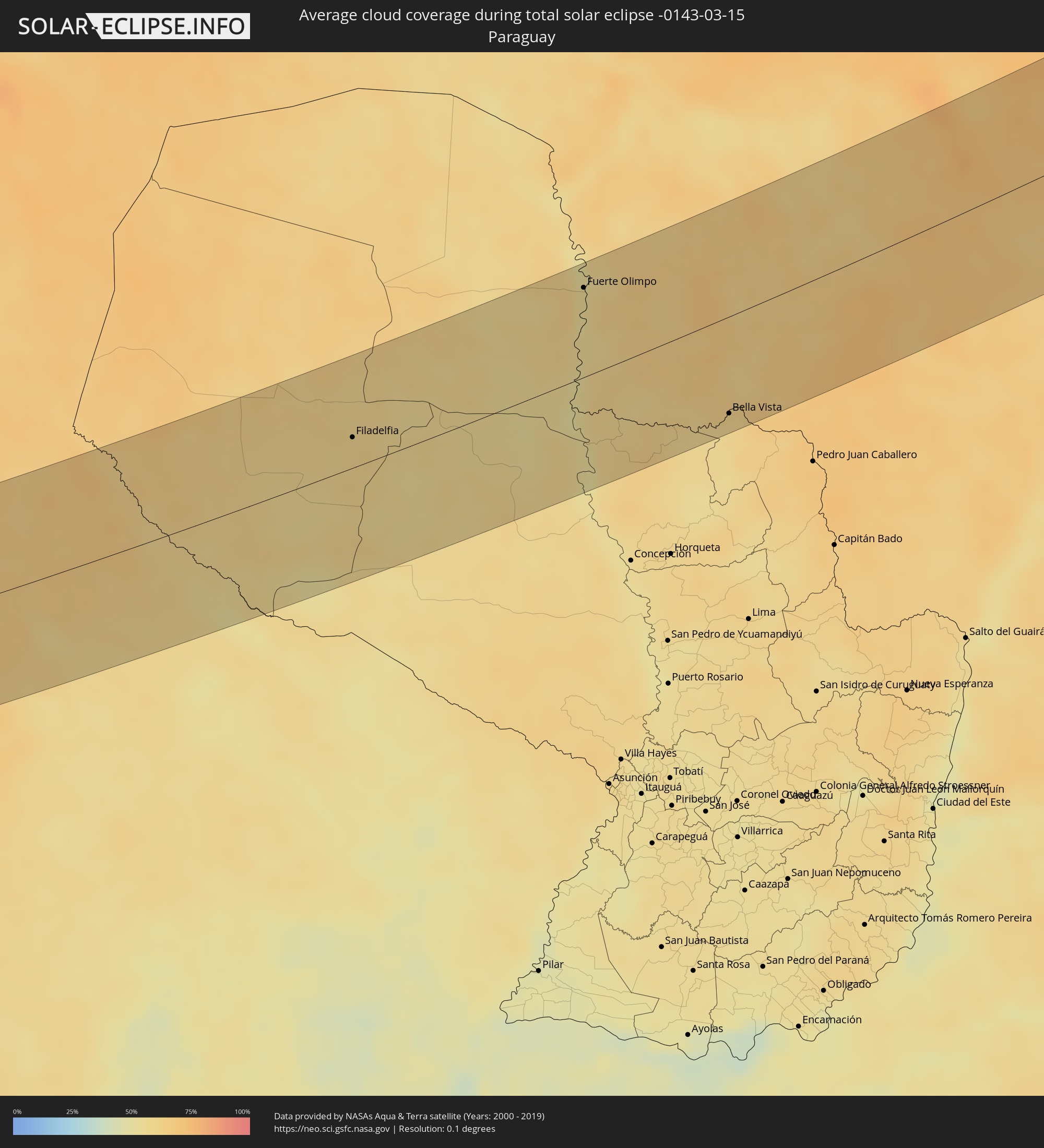 Paraguay
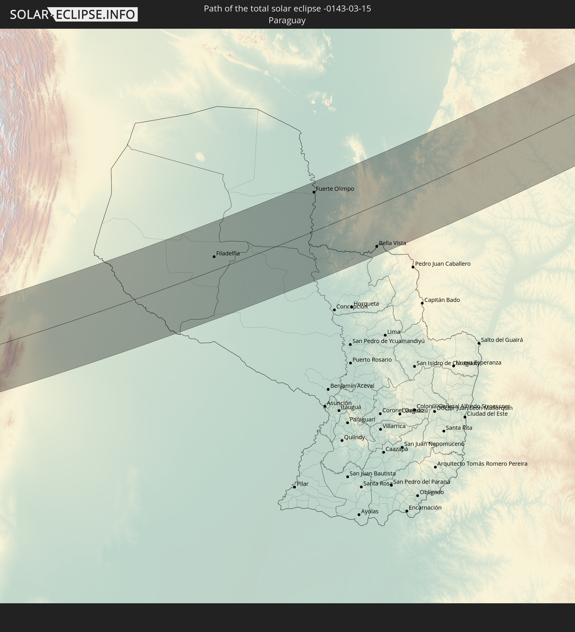
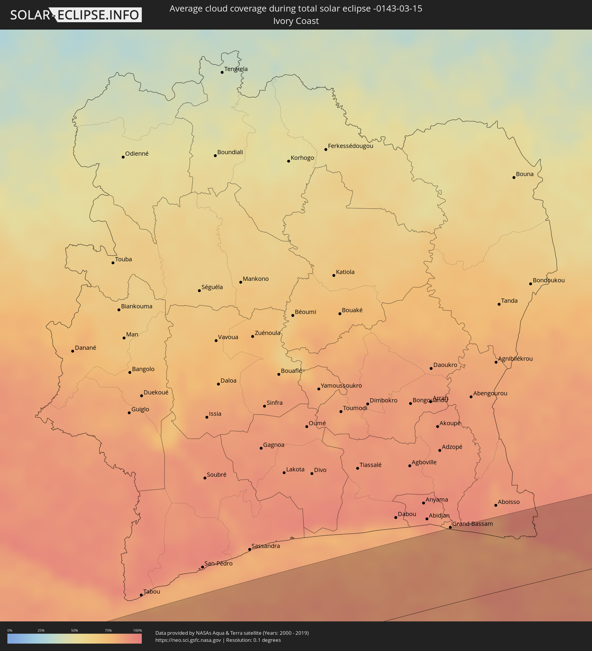 Elfenbeinküste
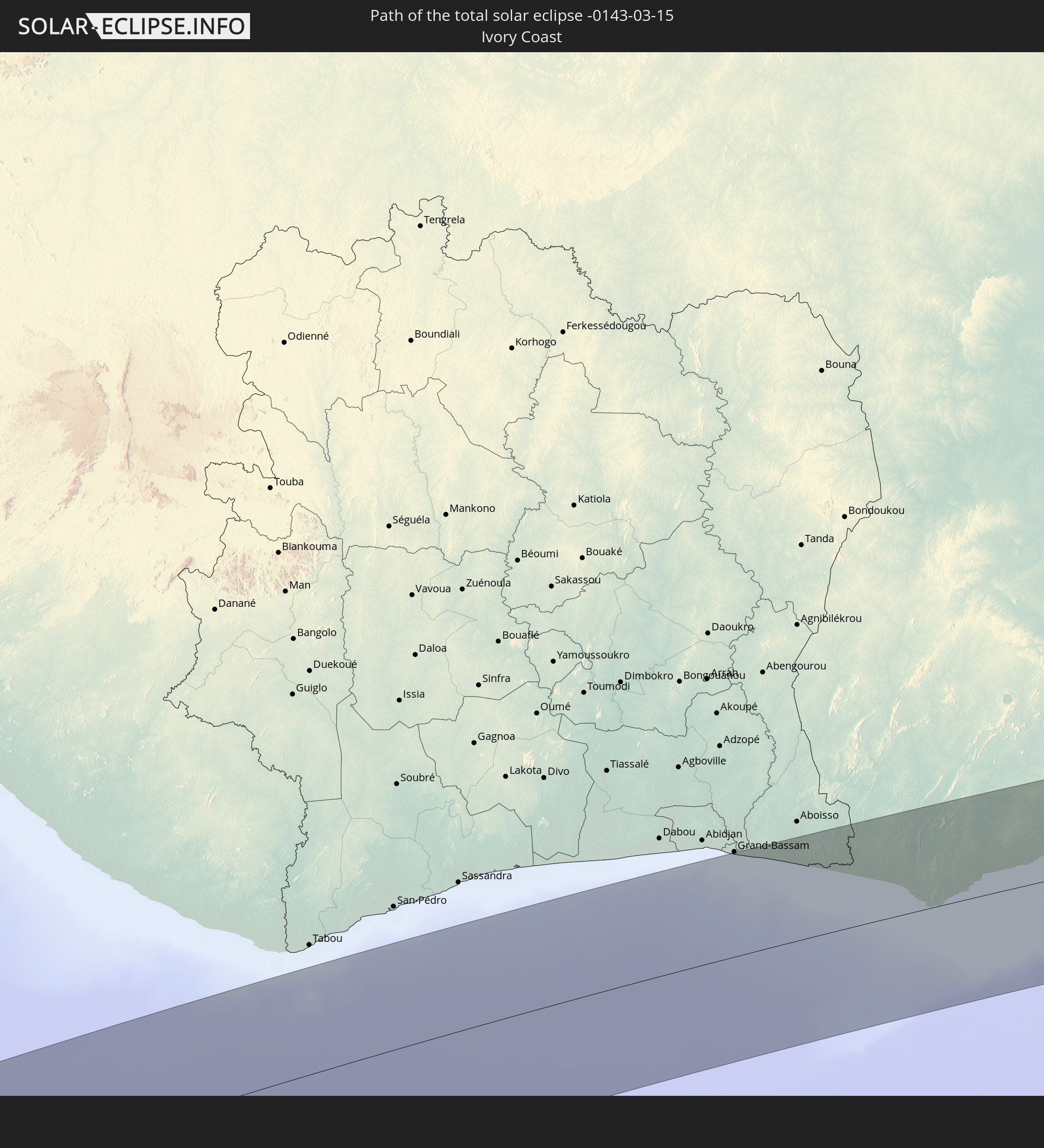
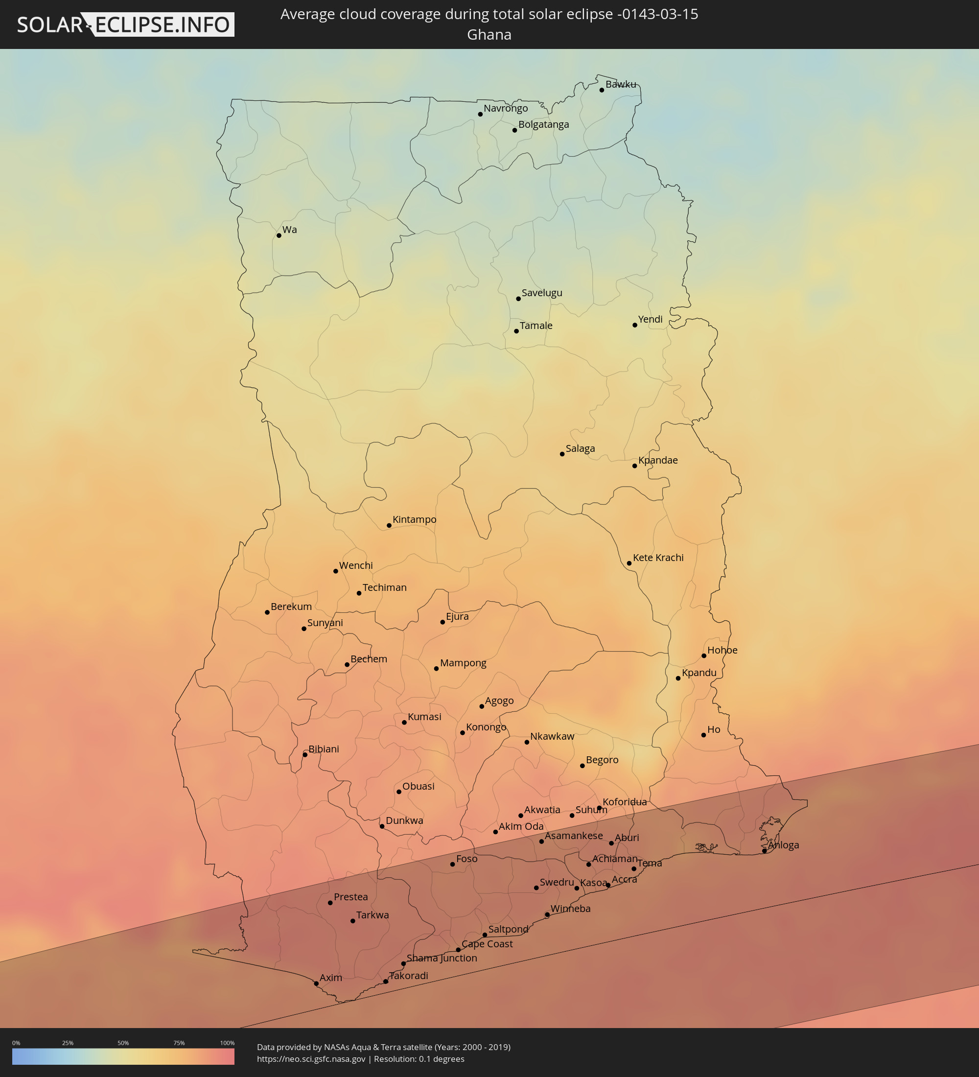 Ghana
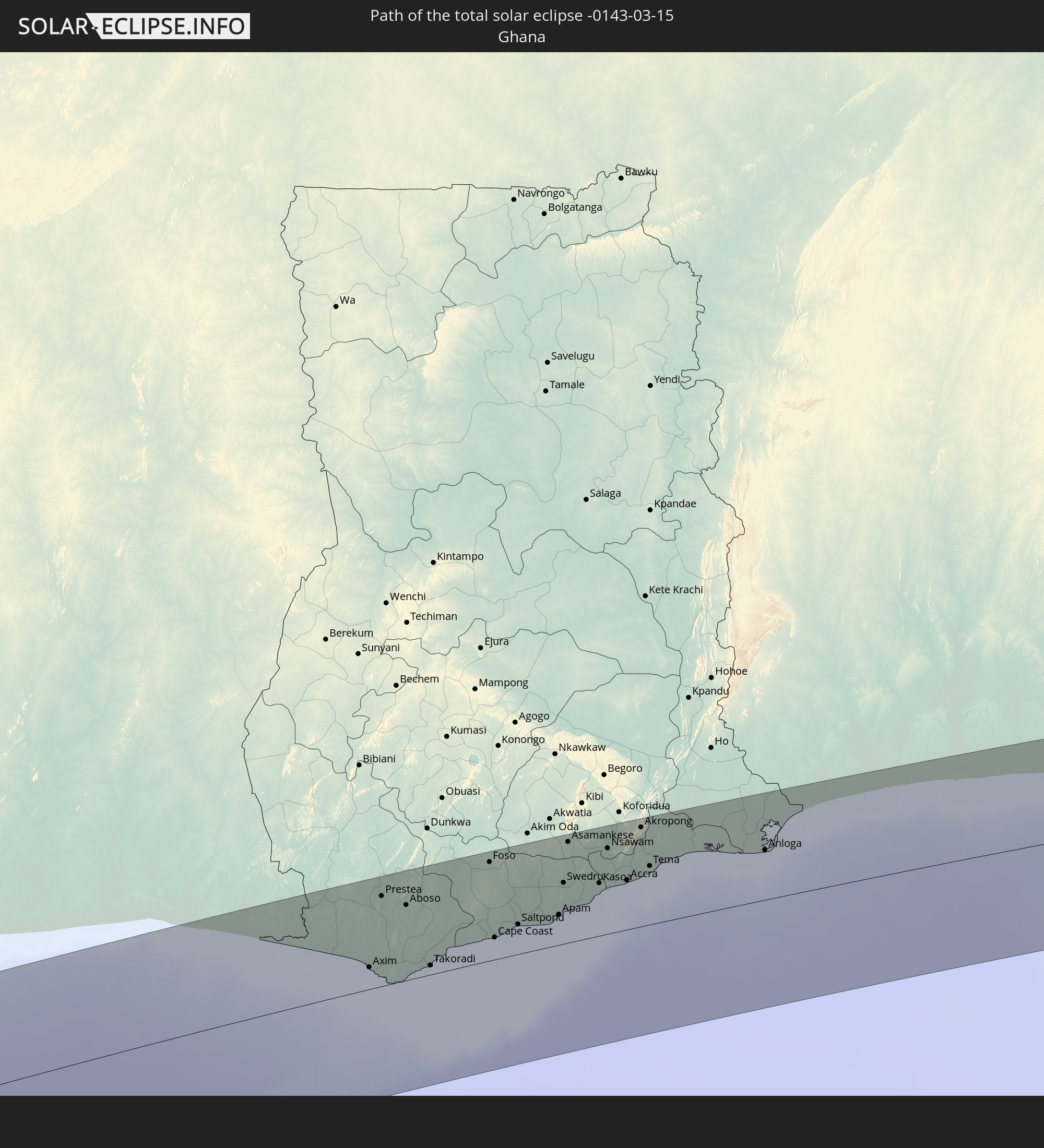
Ghana
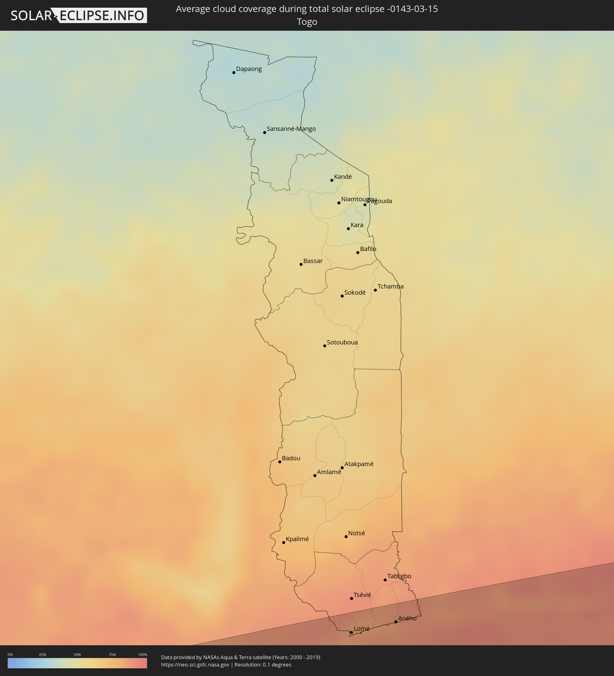 Togo
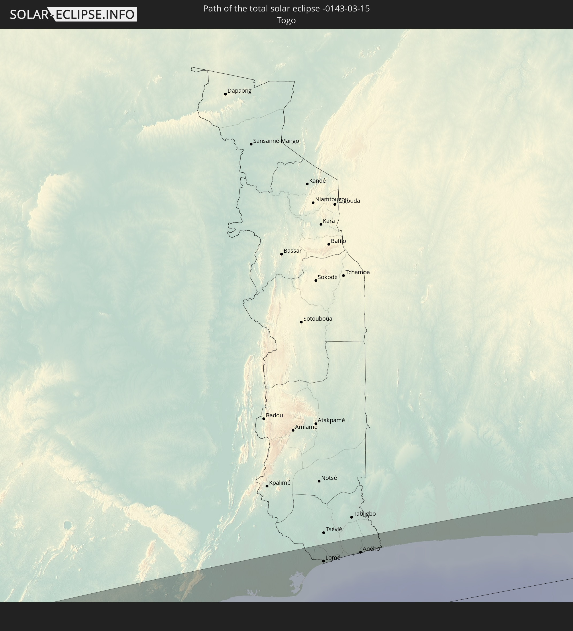
Togo
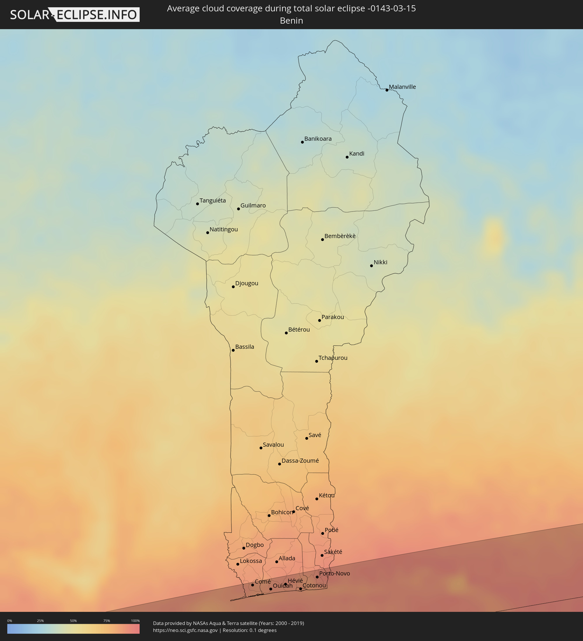 Benin
Benin
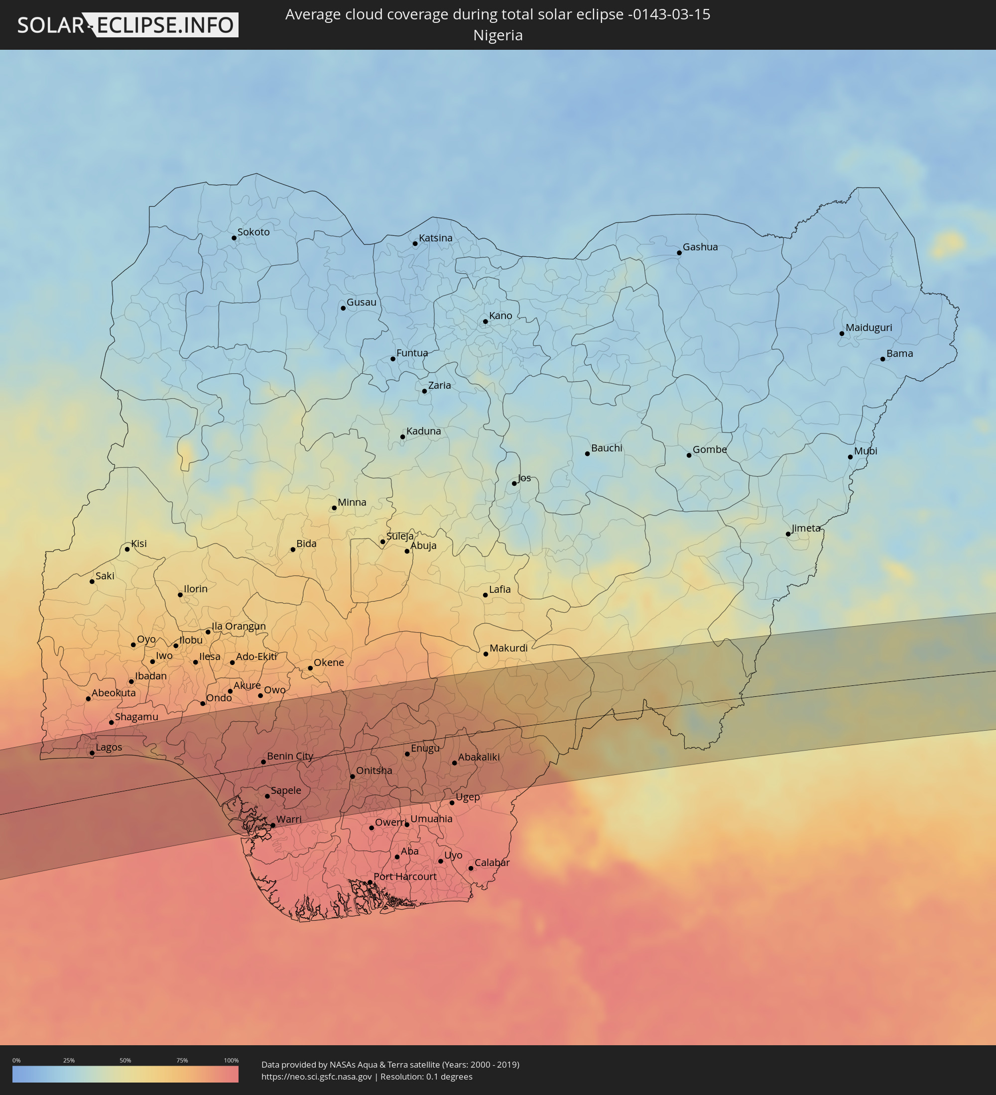 Nigeria
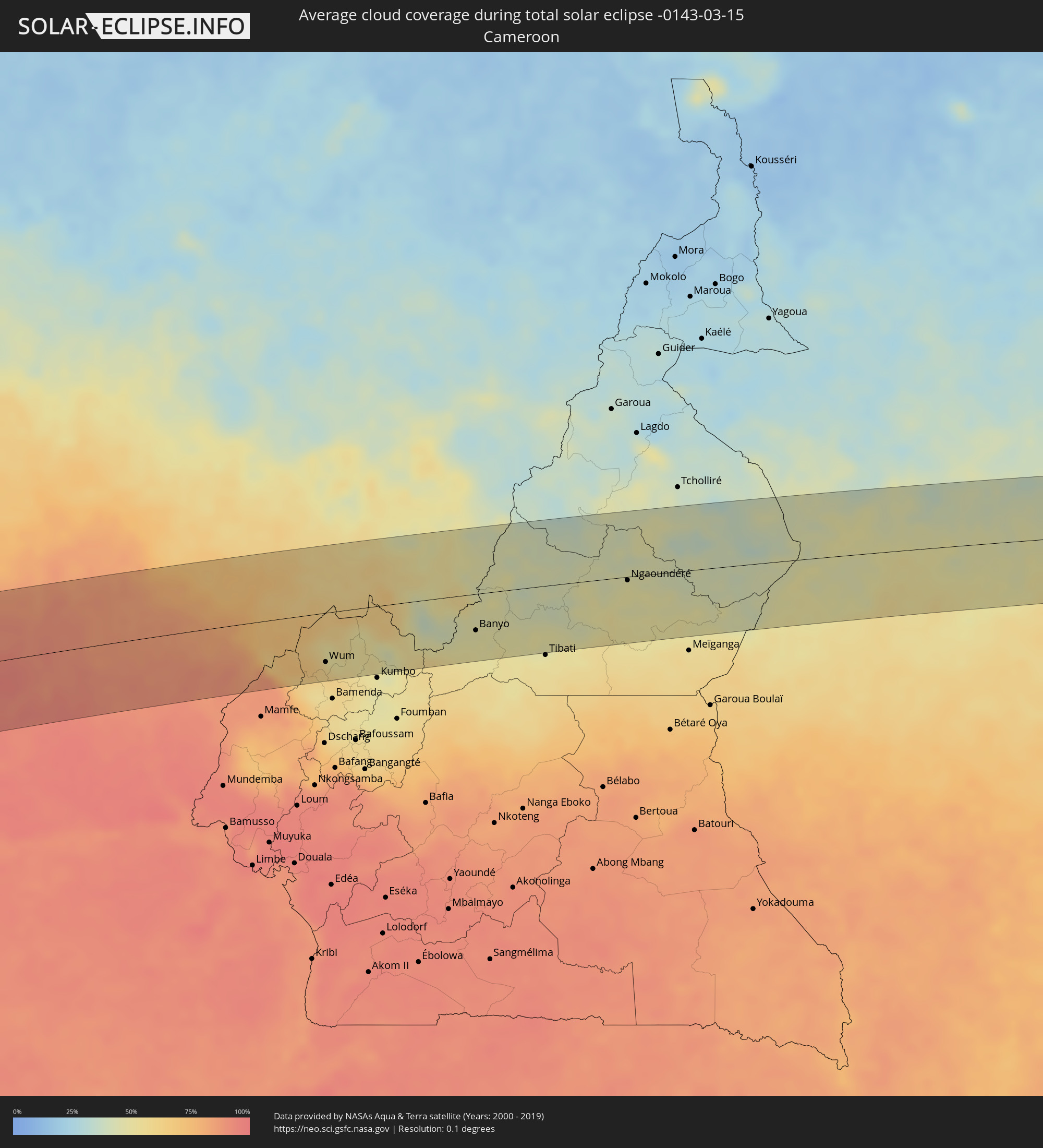 Kamerun
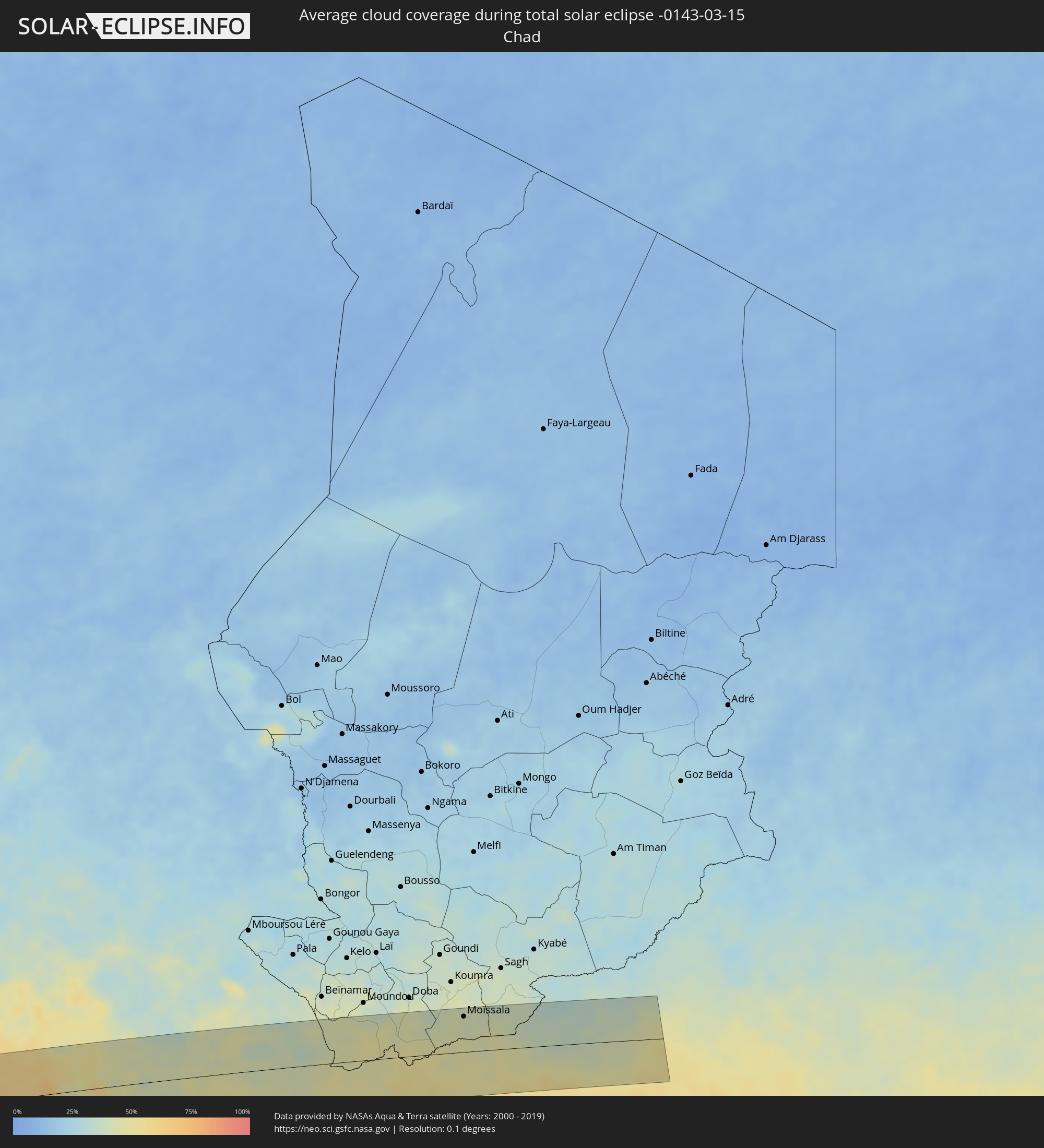 Tschad
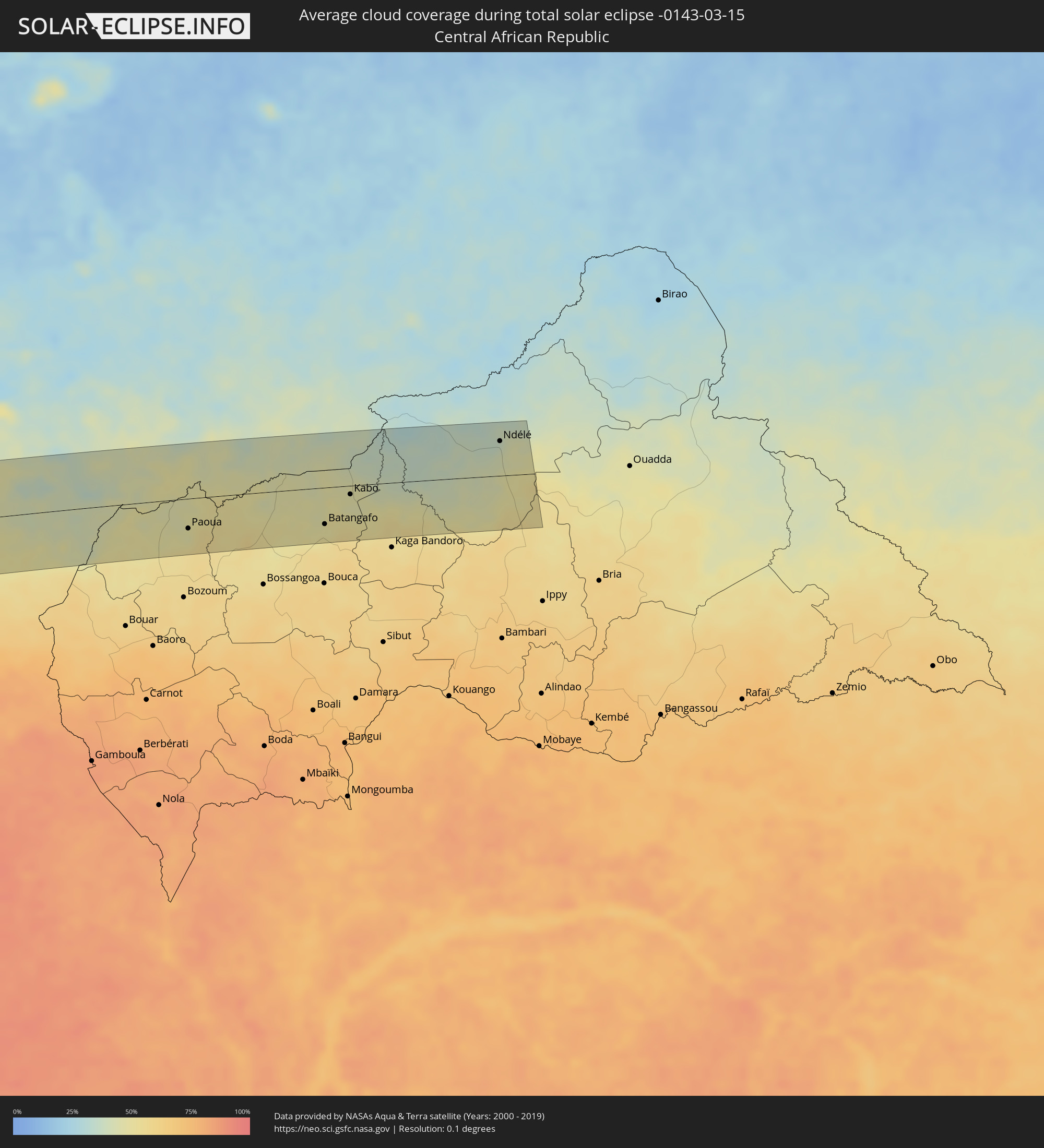 Zentralafrikanische Republik
Orte im Finsternispfad
Die nachfolgene Tabelle zeigt Städte und Orte mit mehr als 5.000 Einwohnern, die sich im Finsternispfad befinden. Städte mit mehr als 100.000 Einwohnern sind dick gekennzeichnet. Mit einem Klick auf den Ort öffnet sich eine Detailkarte die die Lage des jeweiligen Ortes zusammen mit dem Verlauf der zentralen Finsternis präsentiert.
| Ort | Typ | Dauer der Verfinsterung | Ortszeit bei maximaler Verfinsterung | Entfernung zur Zentrallinie | Ø Bewölkung |
|
Taltal, Antofagasta
|
total | - | 09:03:24 UTC-04:42 | 14 km | 26% |
|
Chicoana, Salta Province
|
total | - | 09:37:06 UTC-04:16 | 84 km | 63% |
|
El Carril, Salta Province
|
total | - | 09:37:11 UTC-04:16 | 82 km | 63% |
|
Salta, Salta Province
|
total | - | 09:37:25 UTC-04:16 | 54 km | 70% |
|
Tilcara, Jujuy Province
|
total | - | 09:37:59 UTC-04:16 | 73 km | 27% |
|
San Salvador de Jujuy, Jujuy Province
|
total | - | 09:37:50 UTC-04:16 | 6 km | 73% |
|
Palpalá, Jujuy Province
|
total | - | 09:37:57 UTC-04:16 | 3 km | 71% |
|
San Pedro, Jujuy Province
|
total | - | 09:38:33 UTC-04:16 | 11 km | 67% |
|
Fraile Pintado, Jujuy Province
|
total | - | 09:38:47 UTC-04:16 | 18 km | 67% |
|
Libertador General San Martín, Jujuy Province
|
total | - | 09:38:51 UTC-04:16 | 32 km | 72% |
|
Caimancito, Jujuy Province
|
total | - | 09:39:13 UTC-04:16 | 33 km | 69% |
|
Yuto, Jujuy Province
|
total | - | 09:39:28 UTC-04:16 | 39 km | 67% |
|
San Ramón de la Nueva Orán, Salta Province
|
total | - | 09:39:57 UTC-04:16 | 89 km | 72% |
|
Palma Sola, Jujuy Province
|
total | - | 09:39:38 UTC-04:16 | 0 km | 75% |
|
Las Lajitas, Salta Province
|
total | - | 09:39:25 UTC-04:16 | 78 km | 64% |
|
Embarcación, Salta Province
|
total | - | 09:40:19 UTC-04:16 | 74 km | 69% |
|
Apolinario Saravia, Salta Province
|
total | - | 09:39:57 UTC-04:16 | 59 km | 65% |
|
Ingeniero Guillermo N. Juárez, Formosa Province
|
total | - | 09:44:02 UTC-04:16 | 72 km | 59% |
|
Filadelfia, Boquerón
|
total | - | 10:14:31 UTC-03:50 | 27 km | 60% |
|
Colonia Menno, Boquerón
|
total | - | 10:14:55 UTC-03:50 | 17 km | 60% |
|
Fuerte Olimpo, Alto Paraguay
|
total | - | 10:19:46 UTC-03:50 | 80 km | 56% |
|
Bella Vista, Amambay
|
total | - | 10:21:44 UTC-03:50 | 86 km | 60% |
|
Campo Grande, Mato Grosso do Sul
|
total | - | 10:39:21 UTC-03:38 | 8 km | 71% |
|
Ituiutaba, Minas Gerais
|
total | - | 11:24:38 UTC-03:06 | 84 km | 77% |
|
Itumbiara, Goiás
|
total | - | 11:25:52 UTC-03:06 | 42 km | 72% |
|
Caldas Novas, Goiás
|
total | - | 11:28:04 UTC-03:06 | 5 km | 70% |
|
Paracatu, Minas Gerais
|
total | - | 11:32:57 UTC-03:06 | 43 km | 74% |
|
Jequié, Bahia
|
total | - | 12:26:59 UTC-02:34 | 93 km | 75% |
|
Santo Antônio de Jesus, Bahia
|
total | - | 12:30:24 UTC-02:34 | 55 km | 82% |
|
Feira de Santana, Bahia
|
total | - | 12:32:14 UTC-02:34 | 6 km | 83% |
|
Salvador, Bahia
|
total | - | 12:32:16 UTC-02:34 | 99 km | 62% |
|
Alagoinhas, Bahia
|
total | - | 12:33:48 UTC-02:34 | 25 km | 84% |
|
Lauro de Freitas, Bahia
|
total | - | 12:32:51 UTC-02:34 | 102 km | 60% |
|
Camaçari, Bahia
|
total | - | 12:33:10 UTC-02:34 | 84 km | 74% |
|
Itabaiana, Sergipe
|
total | - | 12:38:35 UTC-02:34 | 54 km | 82% |
|
São Cristóvão, Sergipe
|
total | - | 12:38:36 UTC-02:34 | 11 km | 65% |
|
Aracaju, Sergipe
|
total | - | 12:39:06 UTC-02:34 | 13 km | 68% |
|
Arapiraca, Alagoas
|
total | - | 12:41:58 UTC-02:34 | 98 km | 79% |
|
Maceió, Alagoas
|
total | - | 12:44:23 UTC-02:34 | 53 km | 48% |
|
Adiaké, Comoé
|
total | - | 16:17:20 UTC-00:16 | 92 km | 85% |
|
Axim, Western
|
total | - | 16:33:13 UTC-00:00 | 19 km | 85% |
|
Prestea, Western
|
total | - | 16:33:42 UTC-00:00 | 77 km | 92% |
|
Tarkwa, Western
|
total | - | 16:33:44 UTC-00:00 | 59 km | 91% |
|
Takoradi, Western
|
total | - | 16:33:38 UTC-00:00 | 8 km | 87% |
|
Shama Junction, Western
|
total | - | 16:33:49 UTC-00:00 | 18 km | 86% |
|
Elmina, Central
|
total | - | 16:34:06 UTC-00:00 | 19 km | 85% |
|
Cape Coast, Central
|
total | - | 16:34:12 UTC-00:00 | 19 km | 86% |
|
Saltpond, Central
|
total | - | 16:34:25 UTC-00:00 | 26 km | 84% |
|
Apam, Central
|
total | - | 16:34:43 UTC-00:00 | 26 km | 86% |
|
Swedru, Central
|
total | - | 16:34:55 UTC-00:00 | 52 km | 89% |
|
Asamankese, Eastern
|
total | - | 16:35:10 UTC-00:00 | 86 km | 86% |
|
Winneba, Central
|
total | - | 16:34:51 UTC-00:00 | 30 km | 85% |
|
Kasoa, Central
|
total | - | 16:35:08 UTC-00:00 | 45 km | 86% |
|
Achiaman, Greater Accra
|
total | - | 16:35:19 UTC-00:00 | 61 km | 87% |
|
Accra, Greater Accra
|
total | - | 16:35:19 UTC-00:00 | 42 km | 85% |
|
Tema, Greater Accra
|
total | - | 16:35:31 UTC-00:00 | 50 km | 83% |
|
Anloga, Volta
|
total | - | 16:36:16 UTC-00:00 | 43 km | 86% |
|
Lomé, Maritime
|
total | - | 16:21:26 UTC-00:16 | 73 km | 85% |
|
Vogan, Maritime
|
total | - | 16:21:46 UTC-00:16 | 87 km | 82% |
|
Aného, Maritime
|
total | - | 16:21:44 UTC-00:16 | 74 km | 87% |
|
Grand-Popo, Mono
|
total | - | 16:51:38 UTC+00:13 | 75 km | 87% |
|
Comé, Mono
|
total | - | 16:51:45 UTC+00:13 | 88 km | 85% |
|
Ouidah, Atlantique
|
total | - | 16:51:52 UTC+00:13 | 78 km | 85% |
|
Hévié, Atlantique
|
total | - | 16:52:00 UTC+00:13 | 81 km | 89% |
|
Abomey-Calavi, Atlantique
|
total | - | 16:52:05 UTC+00:13 | 82 km | 89% |
|
Cotonou, Littoral
|
total | - | 16:52:04 UTC+00:13 | 72 km | 89% |
|
Porto-Novo, Ouémé
|
total | - | 16:52:16 UTC+00:13 | 82 km | 86% |
|
Ikeja, Lagos
|
total | - | 16:52:46 UTC+00:13 | 78 km | 91% |
|
Lagos, Lagos
|
total | - | 16:52:43 UTC+00:13 | 61 km | 90% |
|
Ebute Ikorodu, Lagos
|
total | - | 16:52:52 UTC+00:13 | 75 km | 88% |
|
Epe, Lagos
|
total | - | 16:53:08 UTC+00:13 | 63 km | 87% |
|
Benin City, Edo
|
total | - | 16:53:53 UTC+00:13 | 5 km | 95% |
|
Sapele, Delta
|
total | - | 16:53:40 UTC+00:13 | 45 km | 94% |
|
Warri, Delta
|
total | - | 16:53:29 UTC+00:13 | 87 km | 95% |
|
Uromi, Edo
|
total | - | 16:54:26 UTC+00:13 | 32 km | 90% |
|
Onitsha, Anambra
|
total | - | 16:54:21 UTC+00:13 | 36 km | 89% |
|
Ihiala, Anambra
|
total | - | 16:54:13 UTC+00:13 | 70 km | 93% |
|
Nnewi, Anambra
|
total | - | 16:54:20 UTC+00:13 | 53 km | 93% |
|
Awka, Anambra
|
total | - | 16:54:31 UTC+00:13 | 34 km | 90% |
|
Okigwe, Imo
|
total | - | 16:54:26 UTC+00:13 | 81 km | 91% |
|
Nsukka, Enugu
|
total | - | 16:55:00 UTC+00:13 | 31 km | 86% |
|
Enugu, Enugu
|
total | - | 16:54:49 UTC+00:13 | 16 km | 88% |
|
Effium, Ebonyi
|
total | - | 16:55:09 UTC+00:13 | 5 km | 86% |
|
Abakaliki, Ebonyi
|
total | - | 16:55:01 UTC+00:13 | 39 km | 88% |
|
Wum, North-West
|
total | - | 16:55:48 UTC+00:13 | 63 km | 57% |
|
Mme-Bafumen, North-West
|
total | - | 16:55:50 UTC+00:13 | 71 km | 60% |
|
Fundong, North-West
|
total | - | 16:55:48 UTC+00:13 | 80 km | 57% |
|
Njinikom, North-West
|
total | - | 16:55:48 UTC+00:13 | 82 km | 59% |
|
Banyo, Adamaoua
|
total | - | 16:56:31 UTC+00:13 | 46 km | 47% |
|
Kontcha, Adamaoua
|
total | - | 16:57:10 UTC+00:13 | 83 km | 42% |
|
Ngaoundéré, Adamaoua
|
total | - | 16:57:13 UTC+00:13 | 4 km | 49% |
|
Bélel, Adamaoua
|
total | - | 16:57:16 UTC+00:13 | 45 km | 49% |
|
Paoua, Ouham-Pendé
|
total | - | 16:57:40 UTC+00:13 | 44 km | 47% |
|
Béboto, Logone Oriental
|
total | - | 17:44:44 UTC+01:00 | 65 km | 45% |
|
Moïssala, Mandoul
|
total | - | 17:44:50 UTC+01:00 | 65 km | 40% |
|
Batangafo, Ouham
|
total | - | 16:57:52 UTC+00:13 | 54 km | 49% |
|
Kabo, Ouham
|
total | - | 16:58:02 UTC+00:13 | 13 km | 46% |
|
Ndélé, Bamingui-Bangoran
|
total | - | 16:58:20 UTC+00:13 | 51 km | 39% |