Hybride Sonnenfinsternis vom 17.06.-0157
| Wochentag: | Donnerstag |
| Maximale Dauer der Verfinsterung: | 01m00s |
| Maximale Breite des Finsternispfades: | 48 km |
| Saroszyklus: | 73 |
| Bedeckungsgrad: | 100% |
| Magnitude: | 1.0121 |
| Gamma: | 0.4943 |
Wo kann man die Sonnenfinsternis vom 17.06.-0157 sehen?
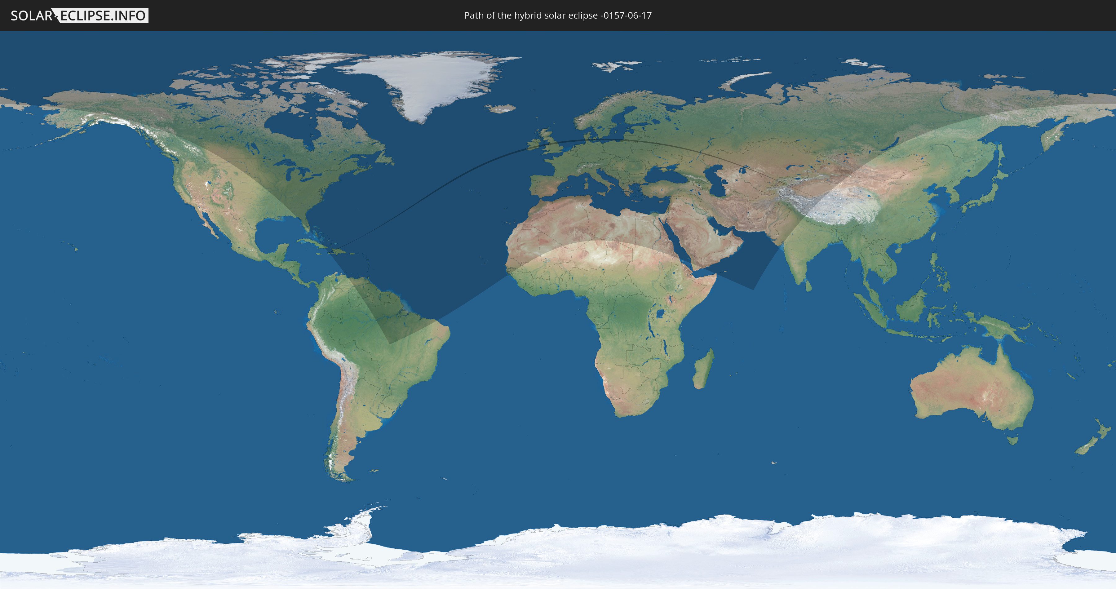
Die Sonnenfinsternis am 17.06.-0157 kann man in 128 Ländern als partielle Sonnenfinsternis beobachten.
Der Finsternispfad verläuft durch 14 Länder. Nur in diesen Ländern ist sie als hybride Sonnenfinsternis zu sehen.
In den folgenden Ländern ist die Sonnenfinsternis hybrid zu sehen
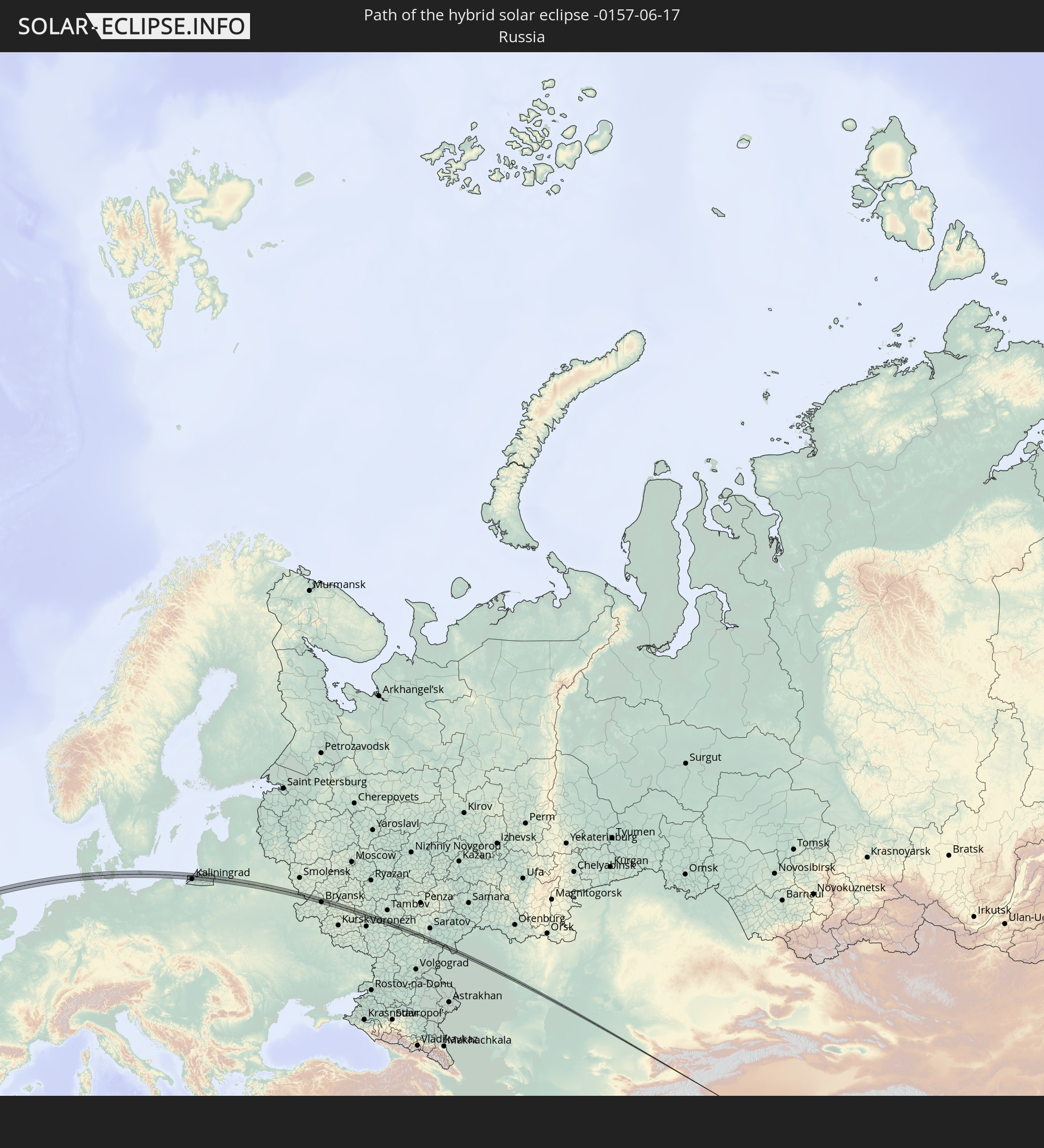 Russland
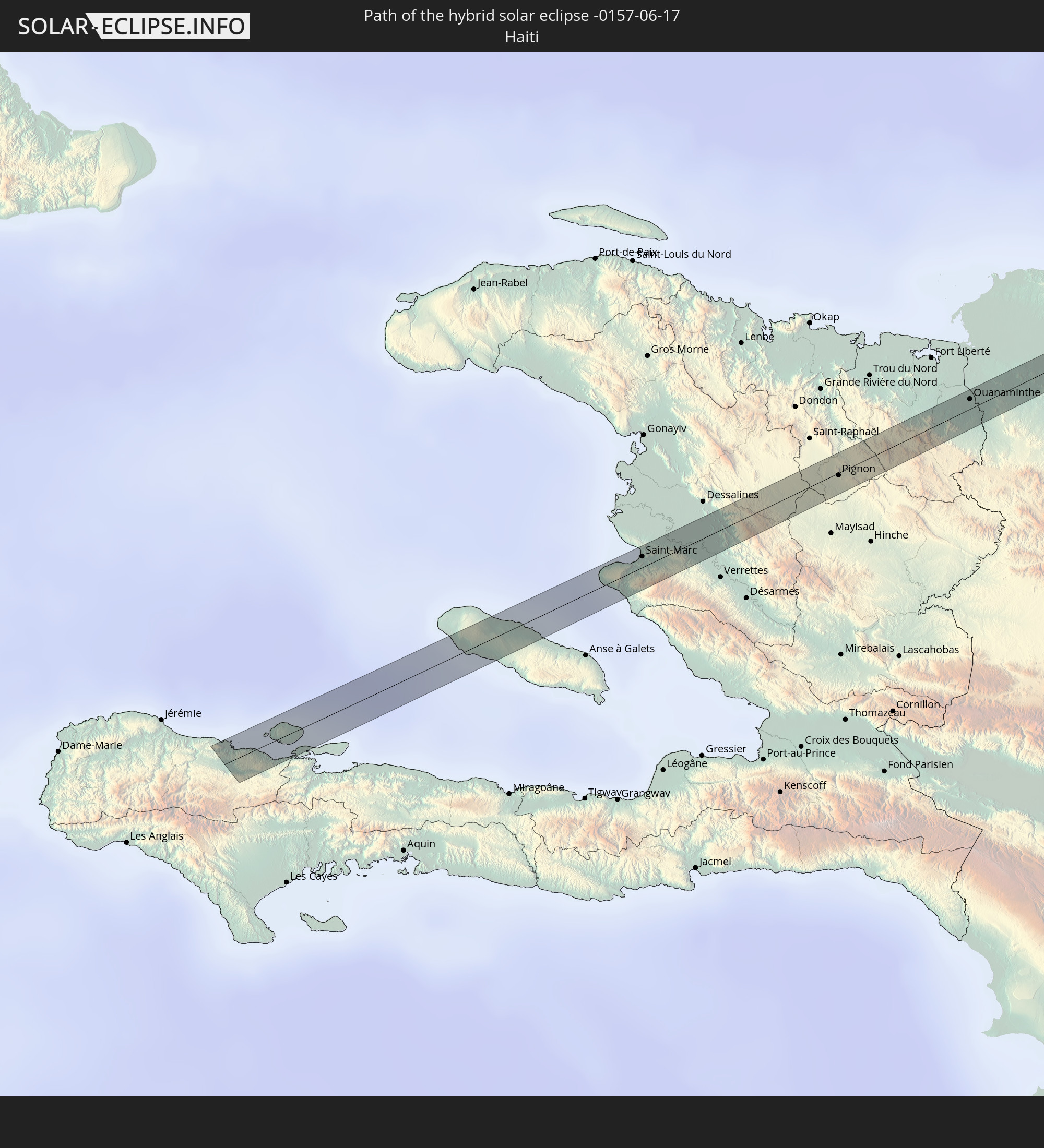 Haiti
Haiti
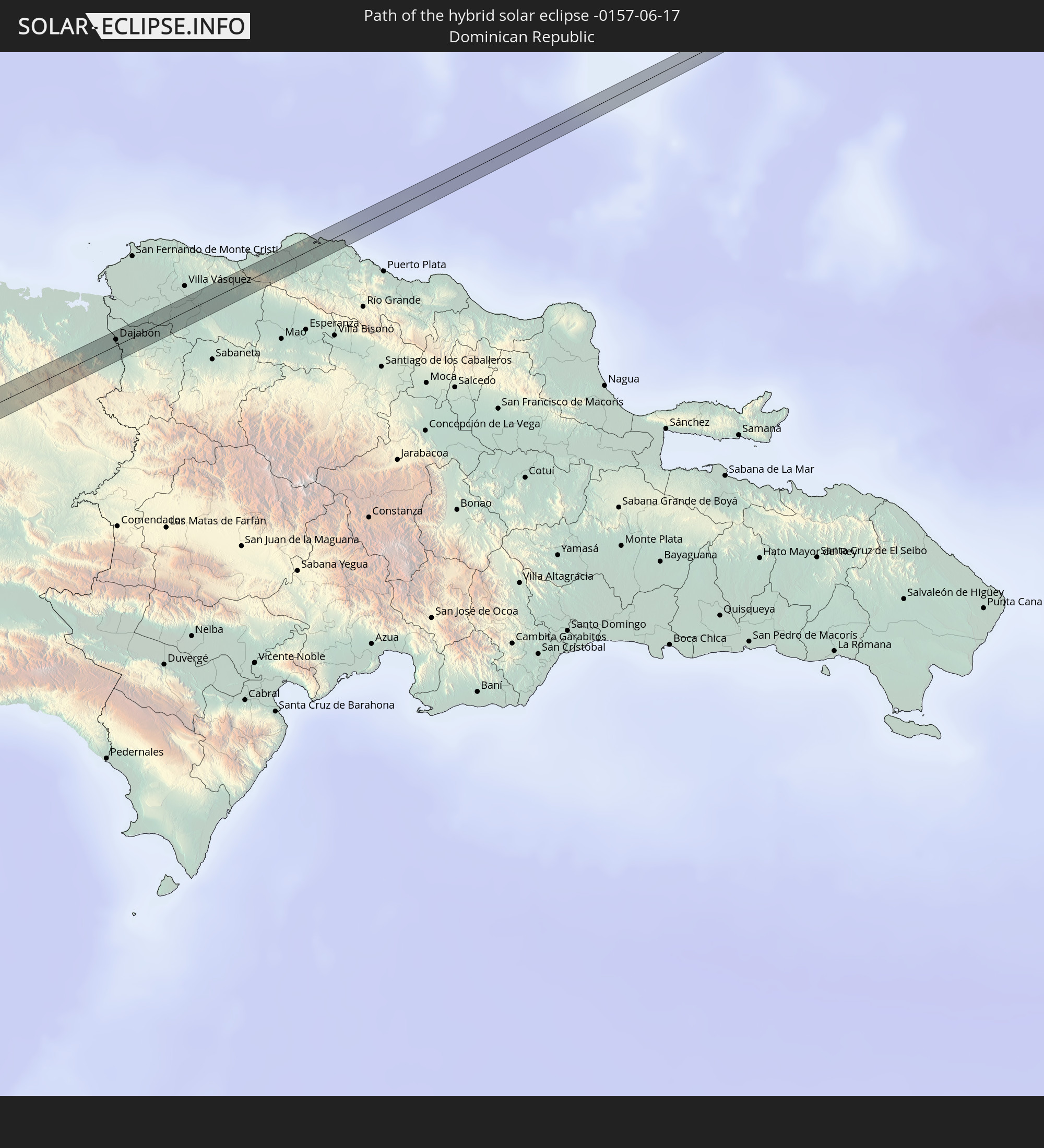 Dominikanische Republik
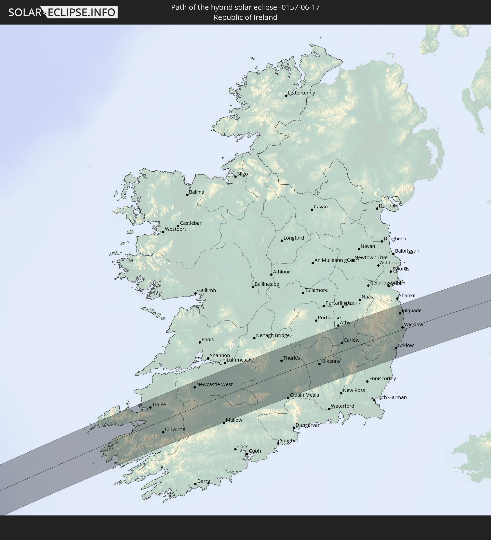 Irland
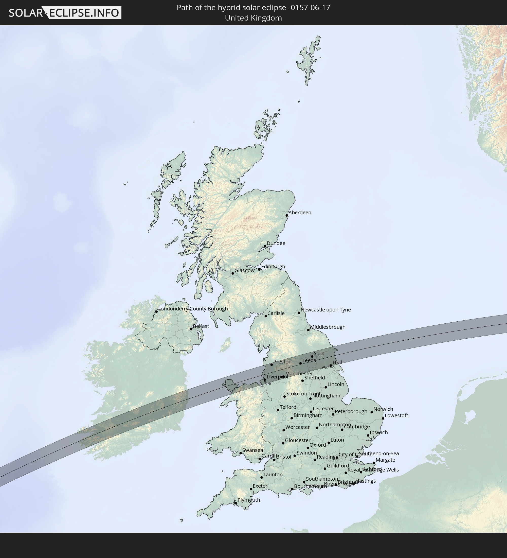 Vereinigtes Königreich
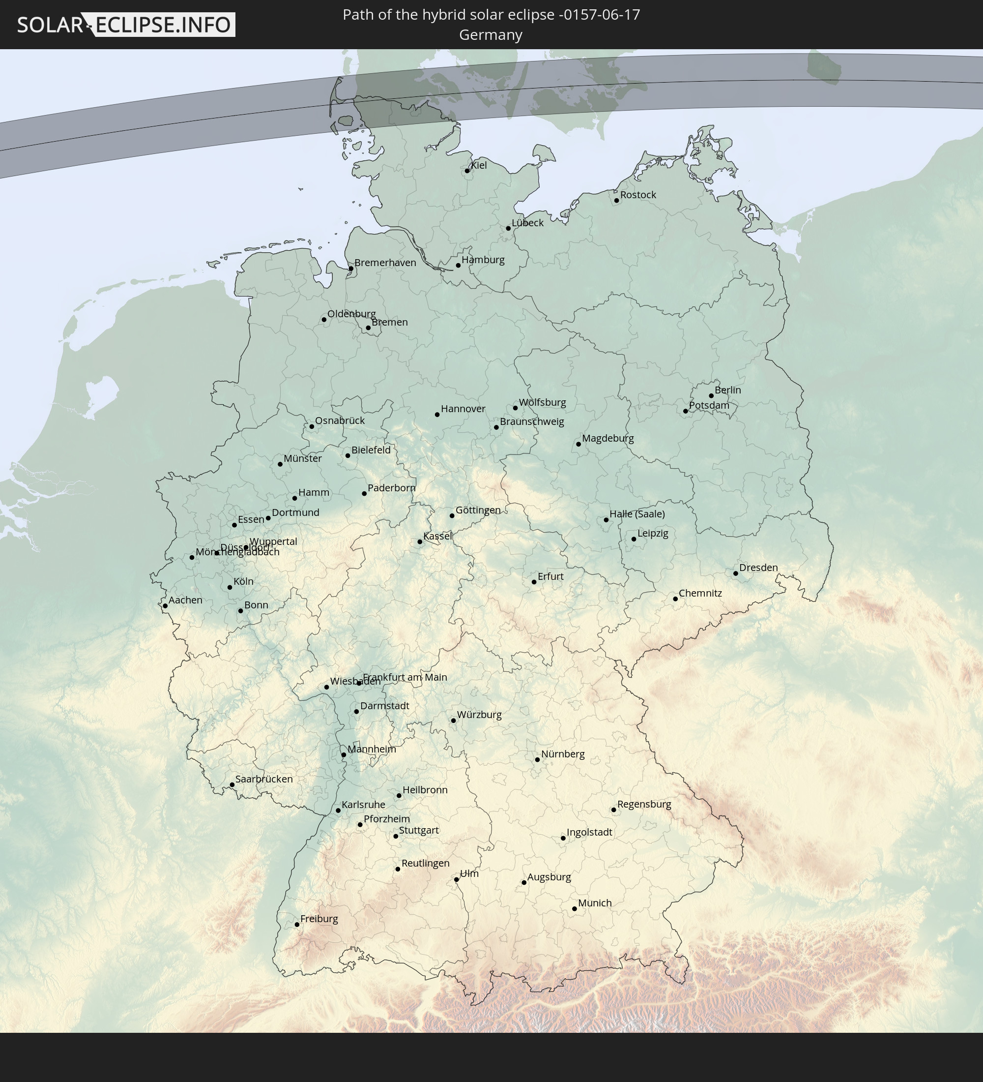 Deutschland
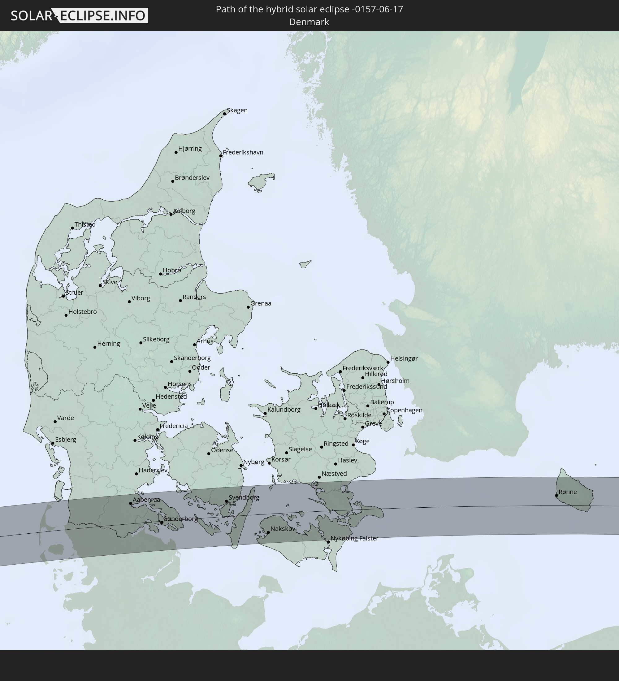 Dänemark
 Polen
Polen
 Litauen
 Weißrussland
 Kasachstan
 Usbekistan
 Kirgisistan
 Volksrepublik China
In den folgenden Ländern ist die Sonnenfinsternis partiell zu sehen
 Russland
 Vereinigte Staaten
 Kanada
 Grönland
 Kuba
Kuba
 Bahamas
 Haiti
Haiti
 Brasilien
 Venezuela
 Turks- und Caicosinseln
 Dominikanische Republik
 Puerto Rico
 Amerikanische Jungferninseln
 Bermuda
 Britische Jungferninseln
 Anguilla
 Saint-Martin
 Saint-Barthélemy
 St. Kitts und Nevis
 Antigua und Barbuda
 Montserrat
 Trinidad und Tobago
 Guadeloupe
 Grenada
 Dominica
 St. Vincent und die Grenadinen
 Guyana
 Martinique
 St. Lucia
 Barbados
 Suriname
 Saint-Pierre und Miquelon
 Französisch-Guayana
 Portugal
 Kap Verde
 Island
 Spanien
 Senegal
 Mauretanien
 Gambia
 Guinea-Bissau
 Marokko
 Mali
Mali
 Irland
 Spitzbergen
 Algerien
 Vereinigtes Königreich
 Färöer
 Gibraltar
 Frankreich
 Isle of Man
 Guernsey
 Jersey
 Niger
Niger
 Andorra
 Belgien
 Niederlande
 Norwegen
 Luxemburg
 Deutschland
 Schweiz
 Italien
 Monaco
 Tunesien
 Dänemark
 Libyen
 Liechtenstein
 Österreich
 Schweden
 Tschechien
 San Marino
 Vatikanstadt
 Slowenien
 Tschad
 Kroatien
 Polen
Polen
 Malta
Malta
 Bosnien und Herzegowina
 Ungarn
 Slowakei
 Montenegro
 Serbien
 Albanien
 Åland Islands
 Griechenland
 Rumänien
 Mazedonien
 Finnland
 Litauen
 Lettland
 Estland
 Sudan
Sudan
 Ukraine
 Bulgarien
 Weißrussland
 Ägypten
 Türkei
 Moldawien
 Republik Zypern
 Staat Palästina
 Israel
 Saudi-Arabien
 Jordanien
 Libanon
 Syrien
 Eritrea
 Irak
Irak
 Georgien
 Somalia
 Jemen
Jemen
 Armenien
 Iran
Iran
 Aserbaidschan
 Kasachstan
 Kuwait
 Bahrain
 Katar
Katar
 Vereinigte Arabische Emirate
 Oman
Oman
 Turkmenistan
 Usbekistan
 Afghanistan
 Pakistan
 Tadschikistan
 Indien
 Kirgisistan
 Volksrepublik China
 Mongolei
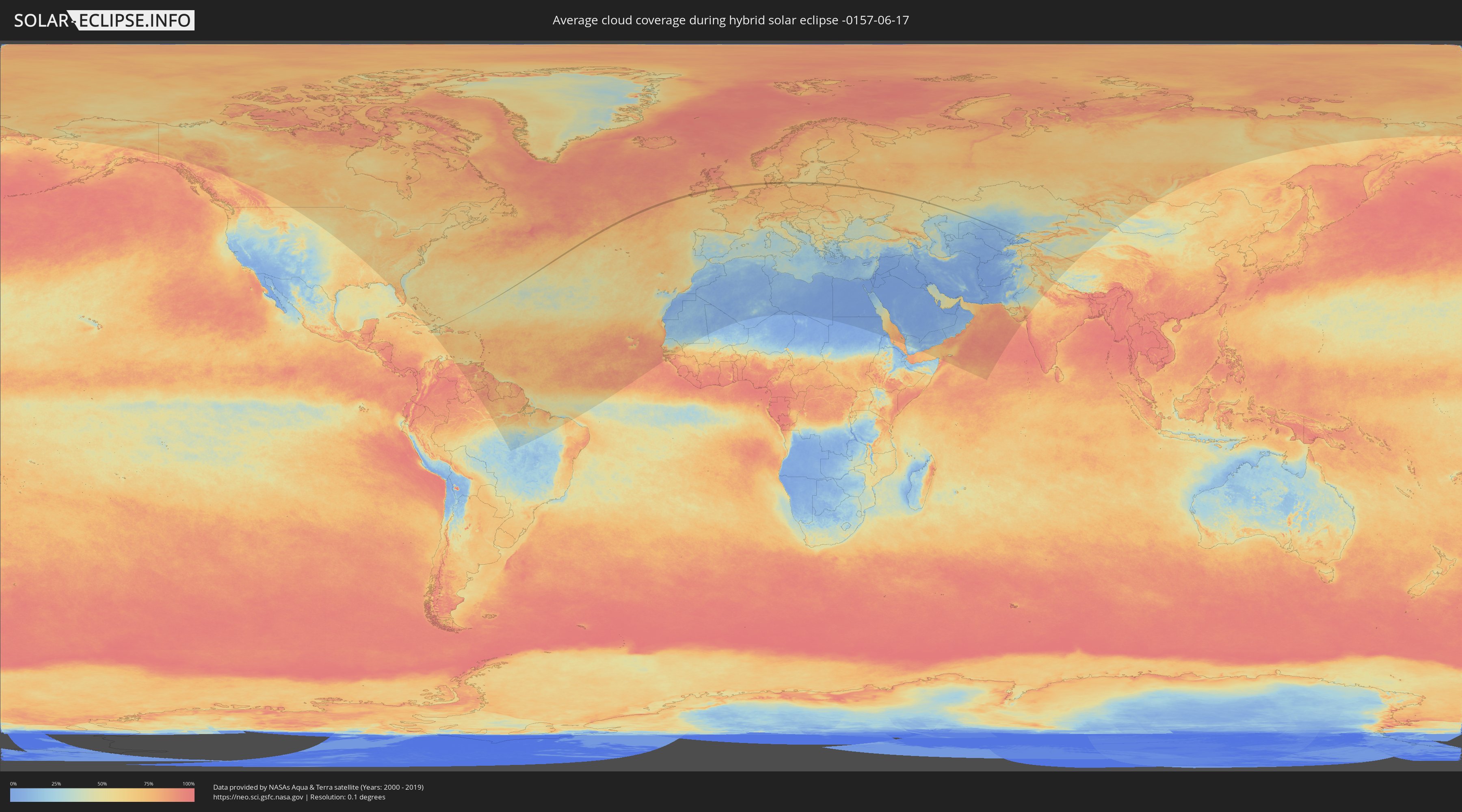
Wie wird das Wetter während der hybriden Sonnenfinsternis am 17.06.-0157?
Wo ist der beste Ort, um die hybride Sonnenfinsternis vom 17.06.-0157 zu beobachten?
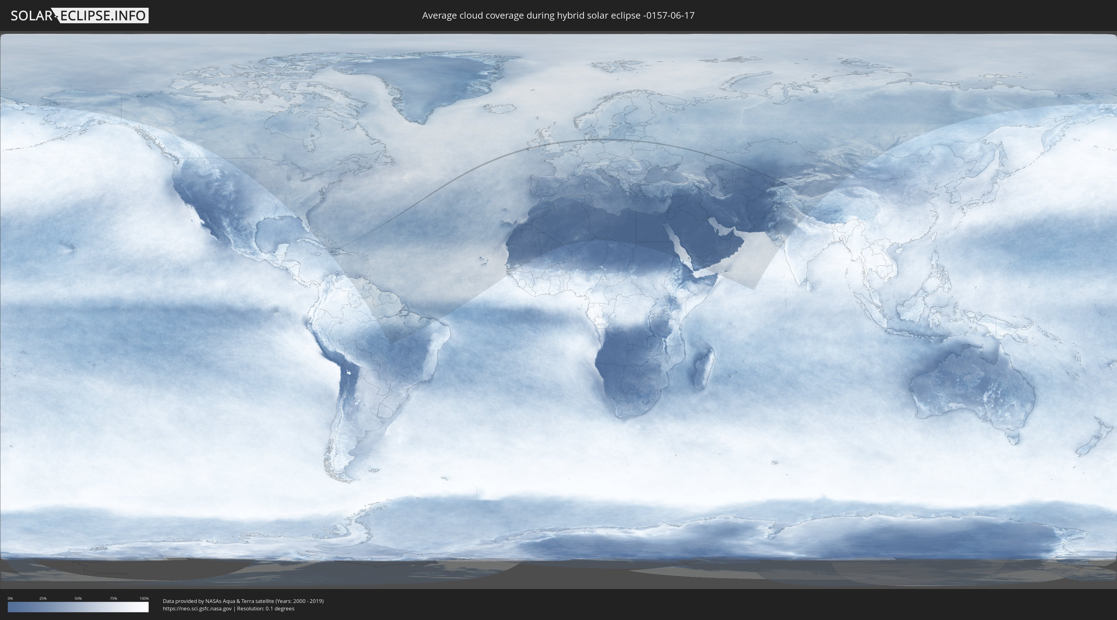
Die folgenden Karten zeigen die durchschnittliche Bewölkung für den Tag, an dem die hybride Sonnenfinsternis
stattfindet. Mit Hilfe der Karten lässt sich der Ort entlang des Finsternispfades eingrenzen,
der die besten Aussichen auf einen klaren wolkenfreien Himmel bietet.
Trotzdem muss man immer lokale Gegenenheiten beachten und sollte sich genau über das Wetter an seinem
gewählten Beobachtungsort informieren.
Die Daten stammen von den beiden NASA-Satelliten
AQUA und TERRA
und wurden über einen Zeitraum von 19 Jahren (2000 - 2019) gemittelt.
Detaillierte Länderkarten
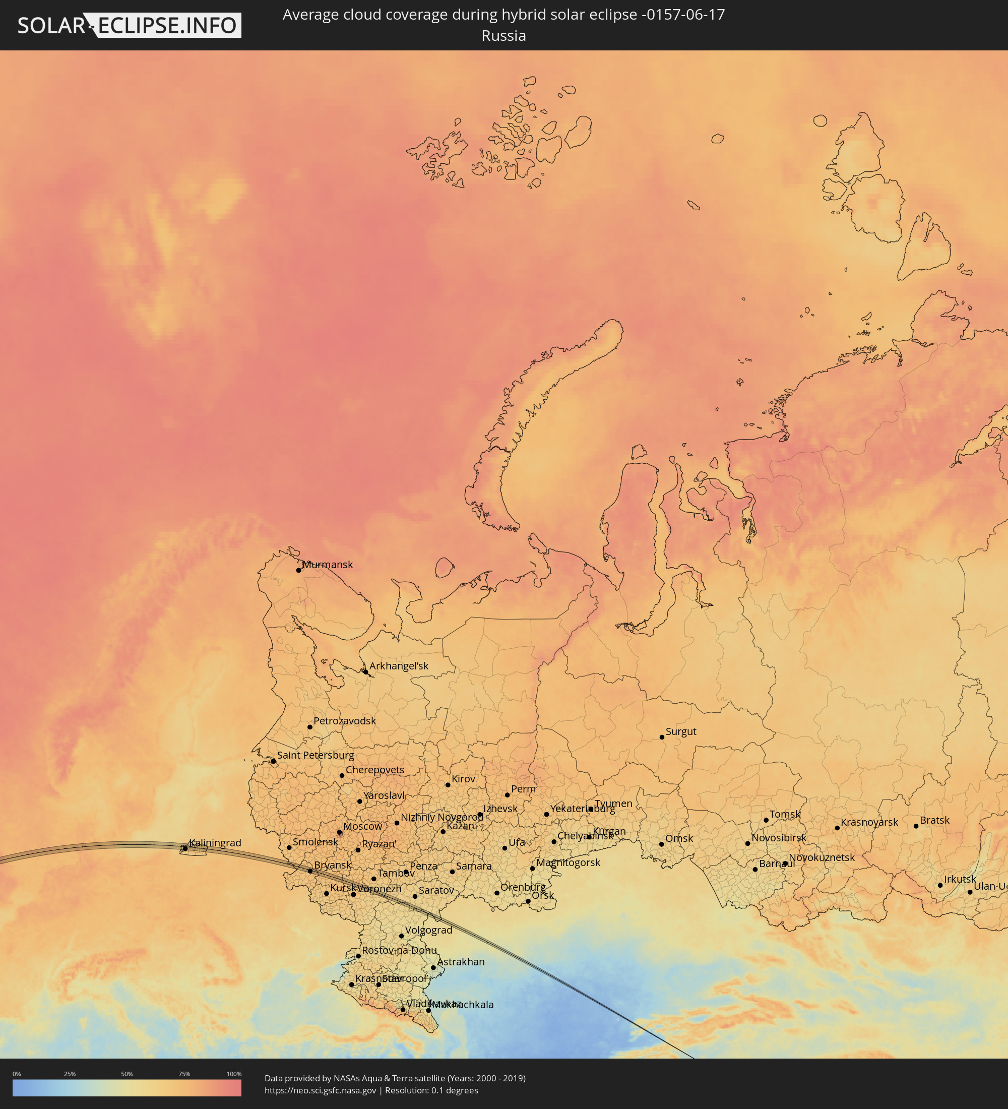 Russland
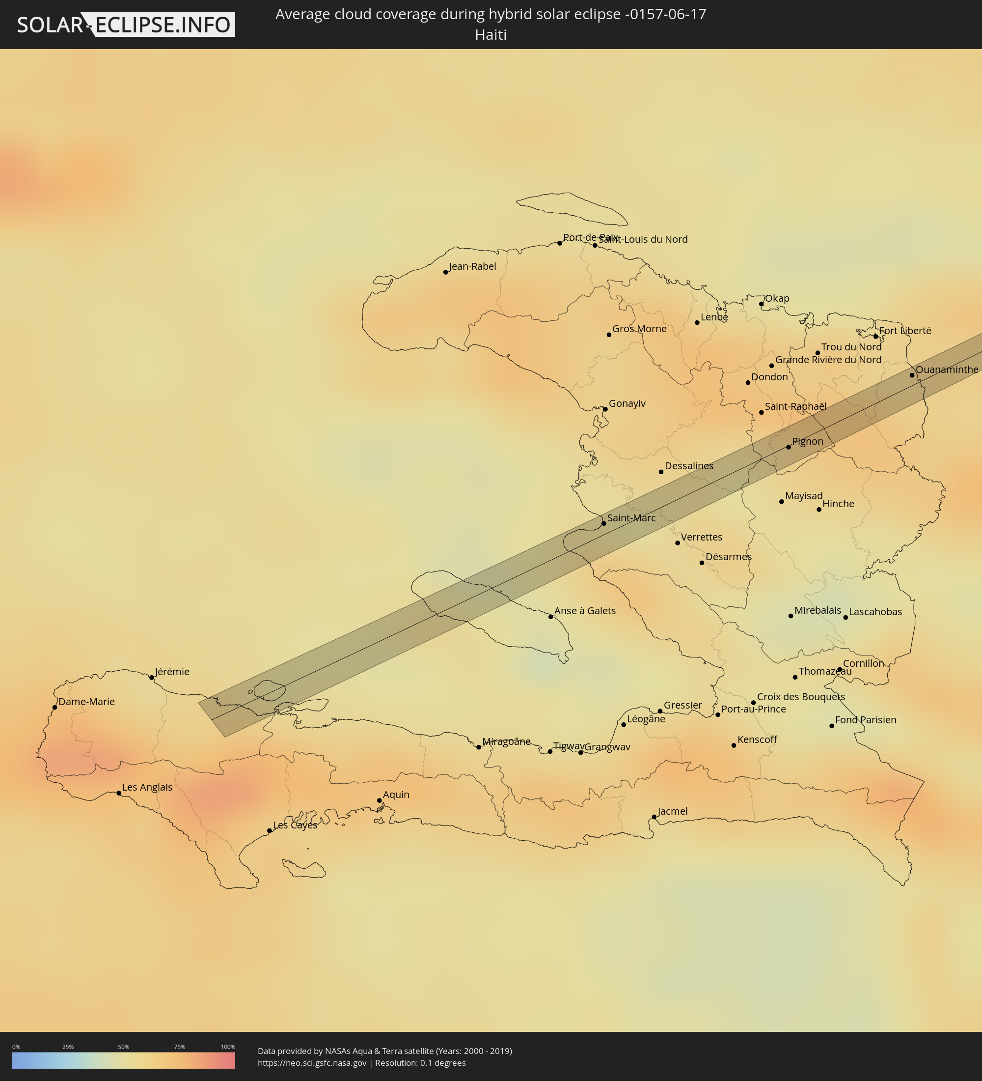 Haiti
Haiti
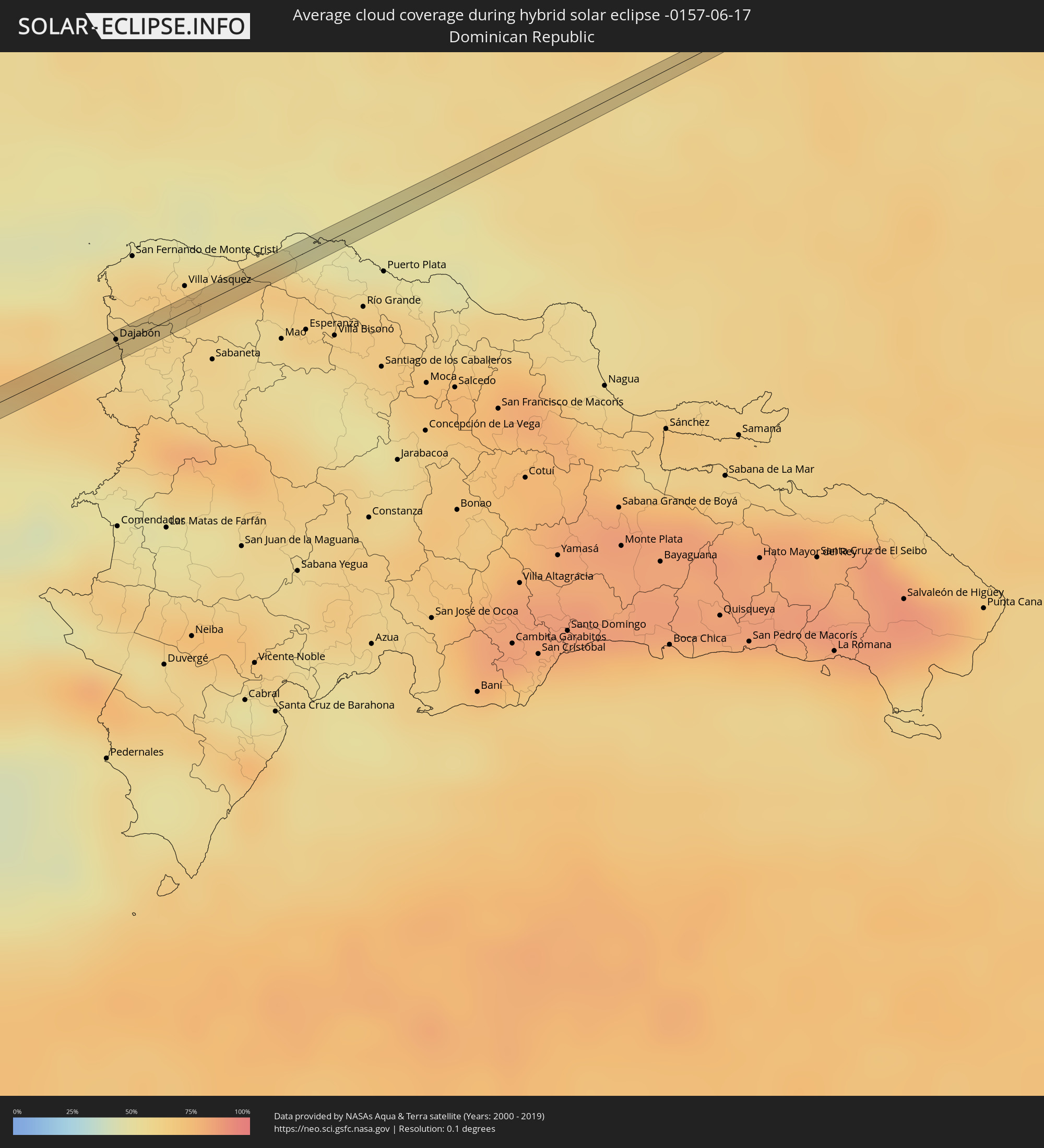 Dominikanische Republik
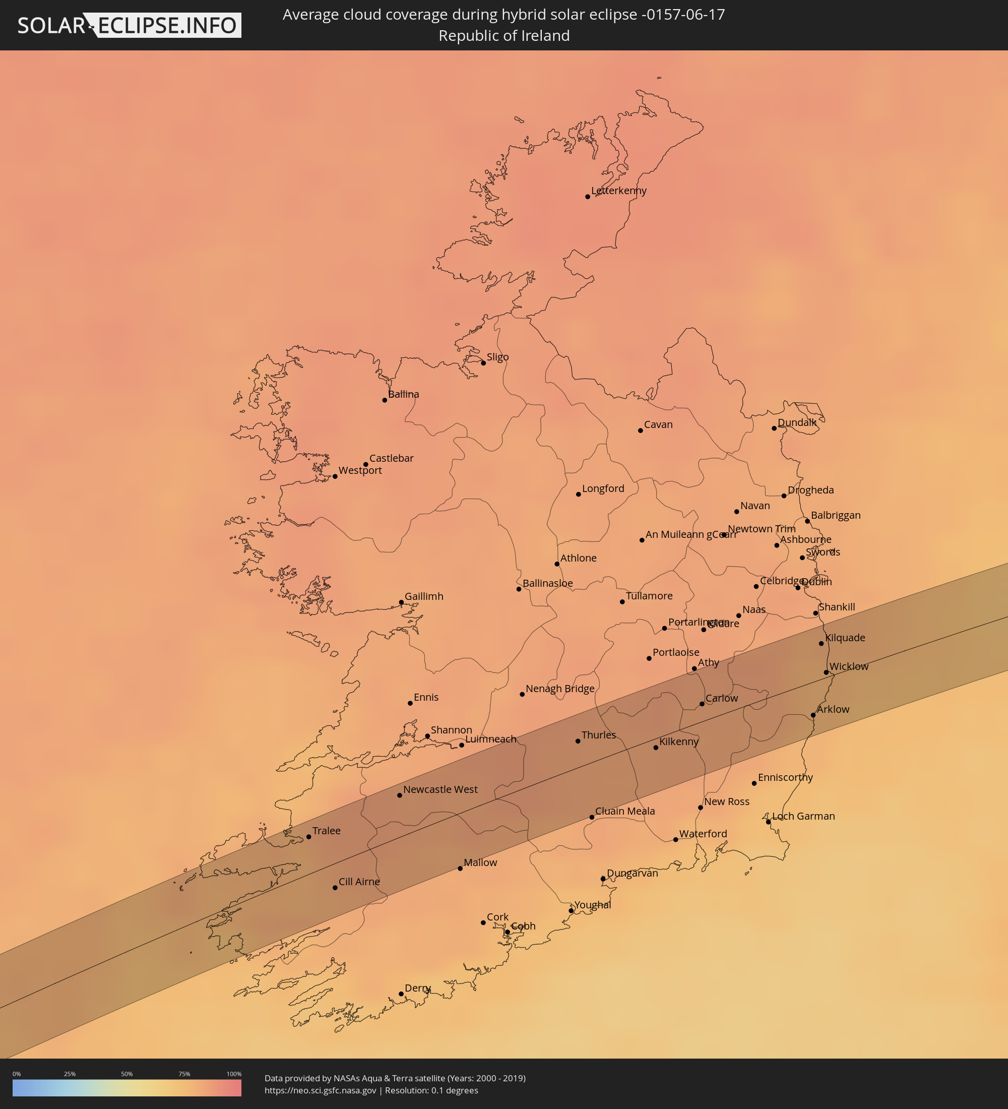 Irland
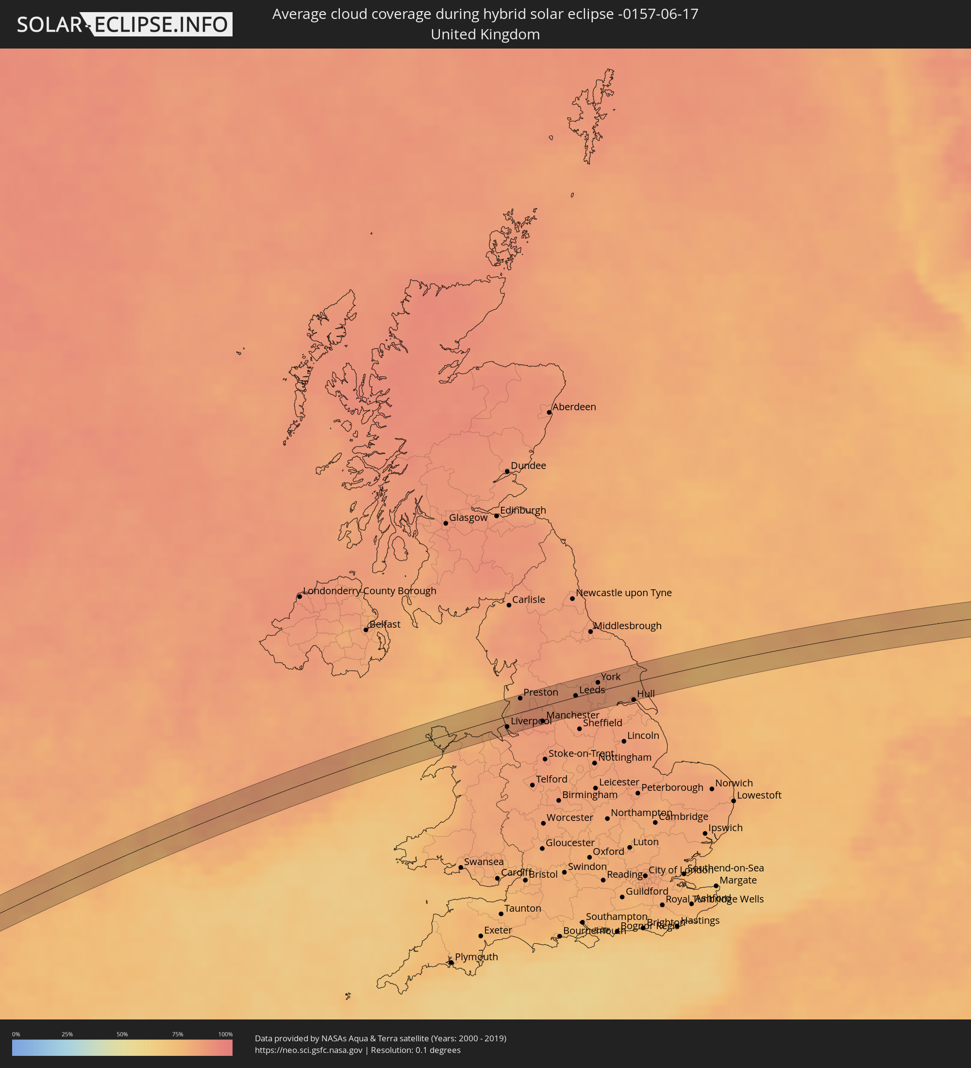 Vereinigtes Königreich
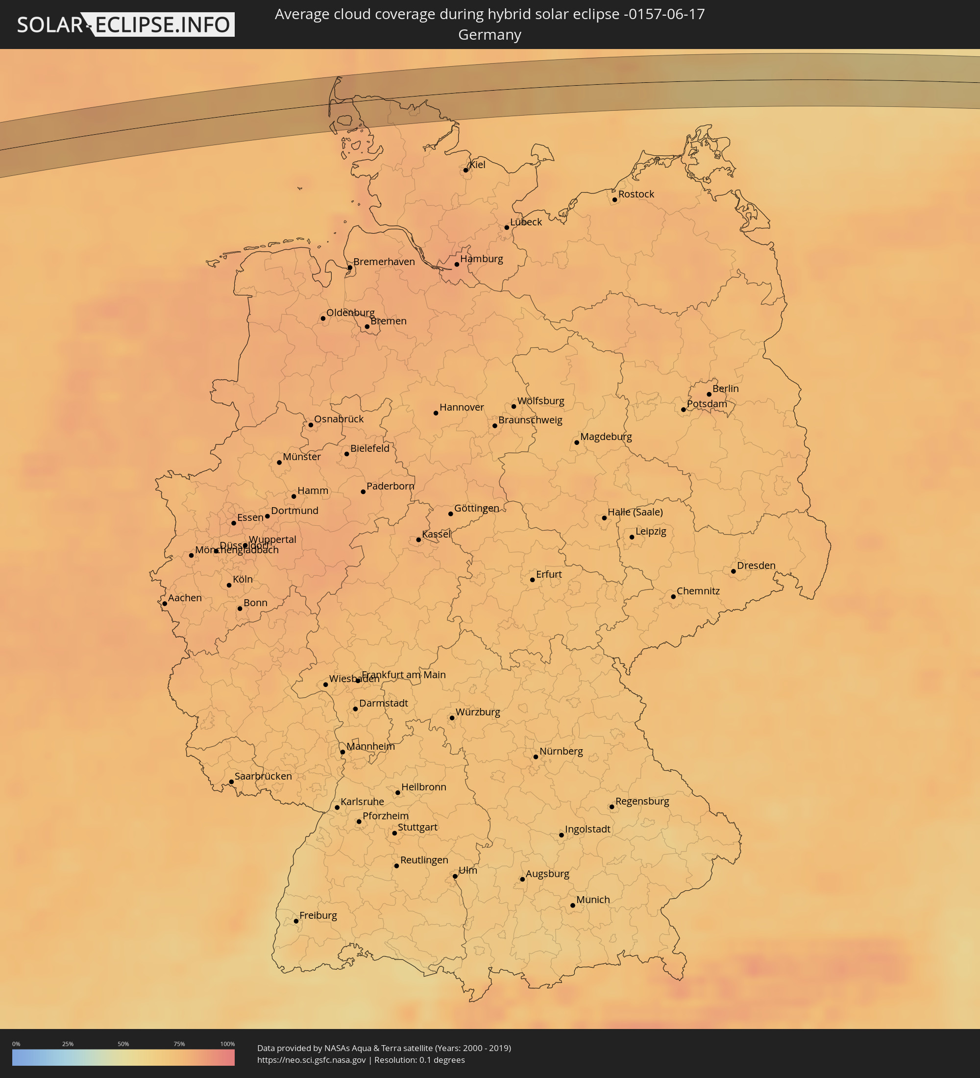 Deutschland
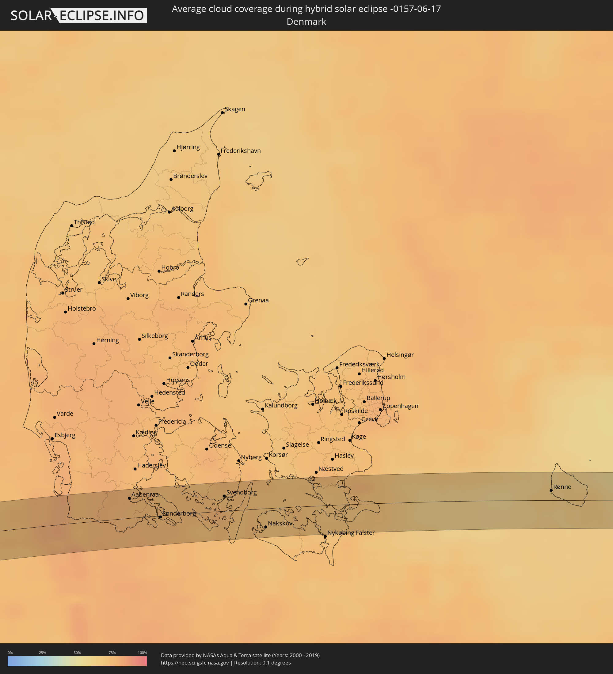 Dänemark
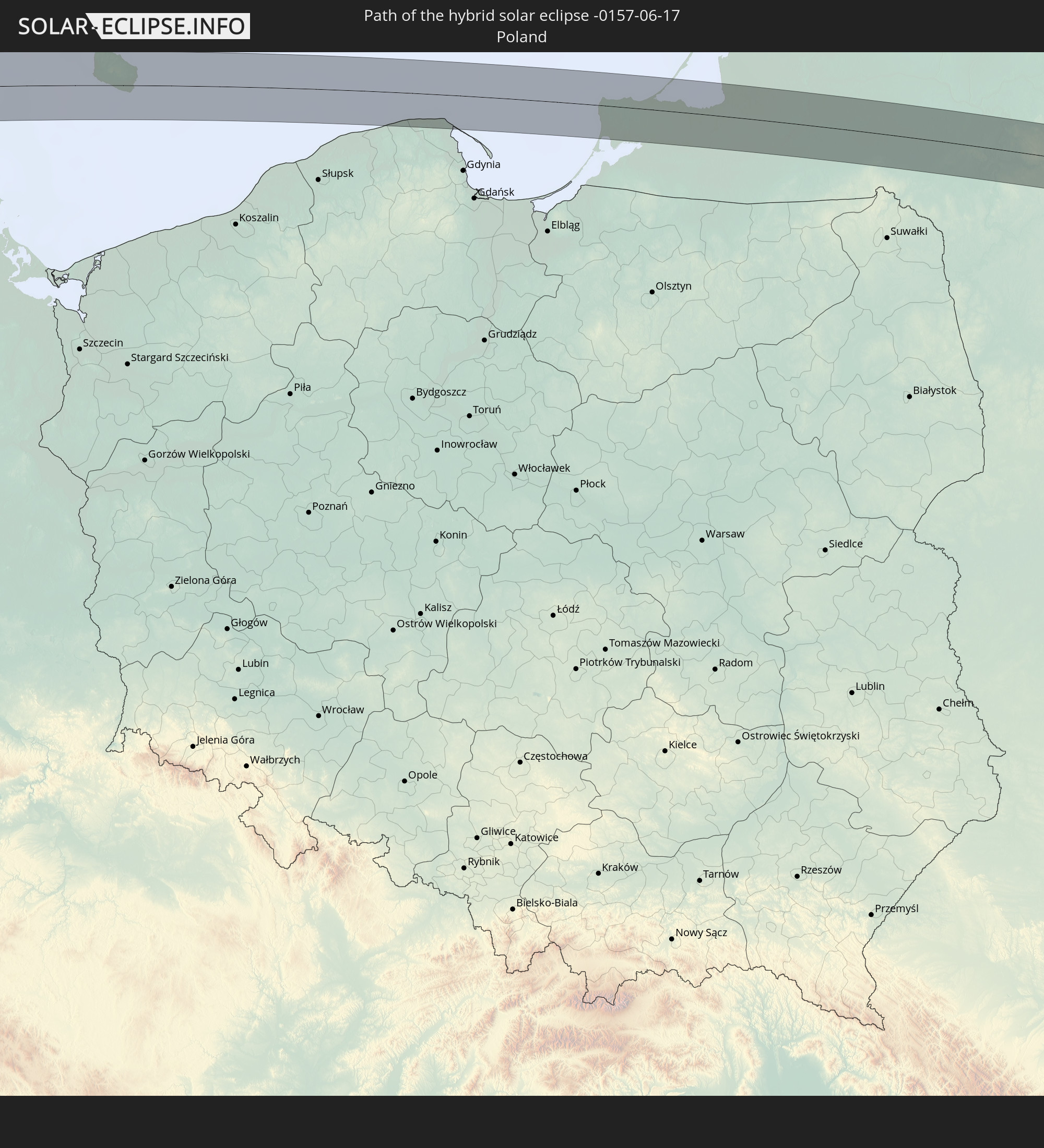
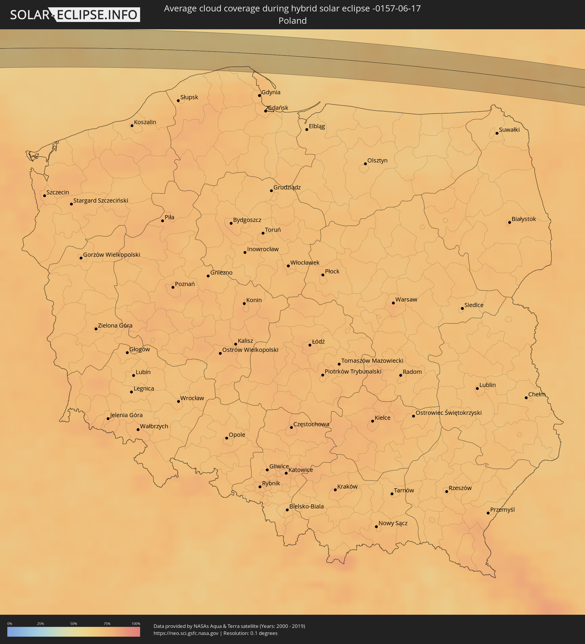 Polen
Polen
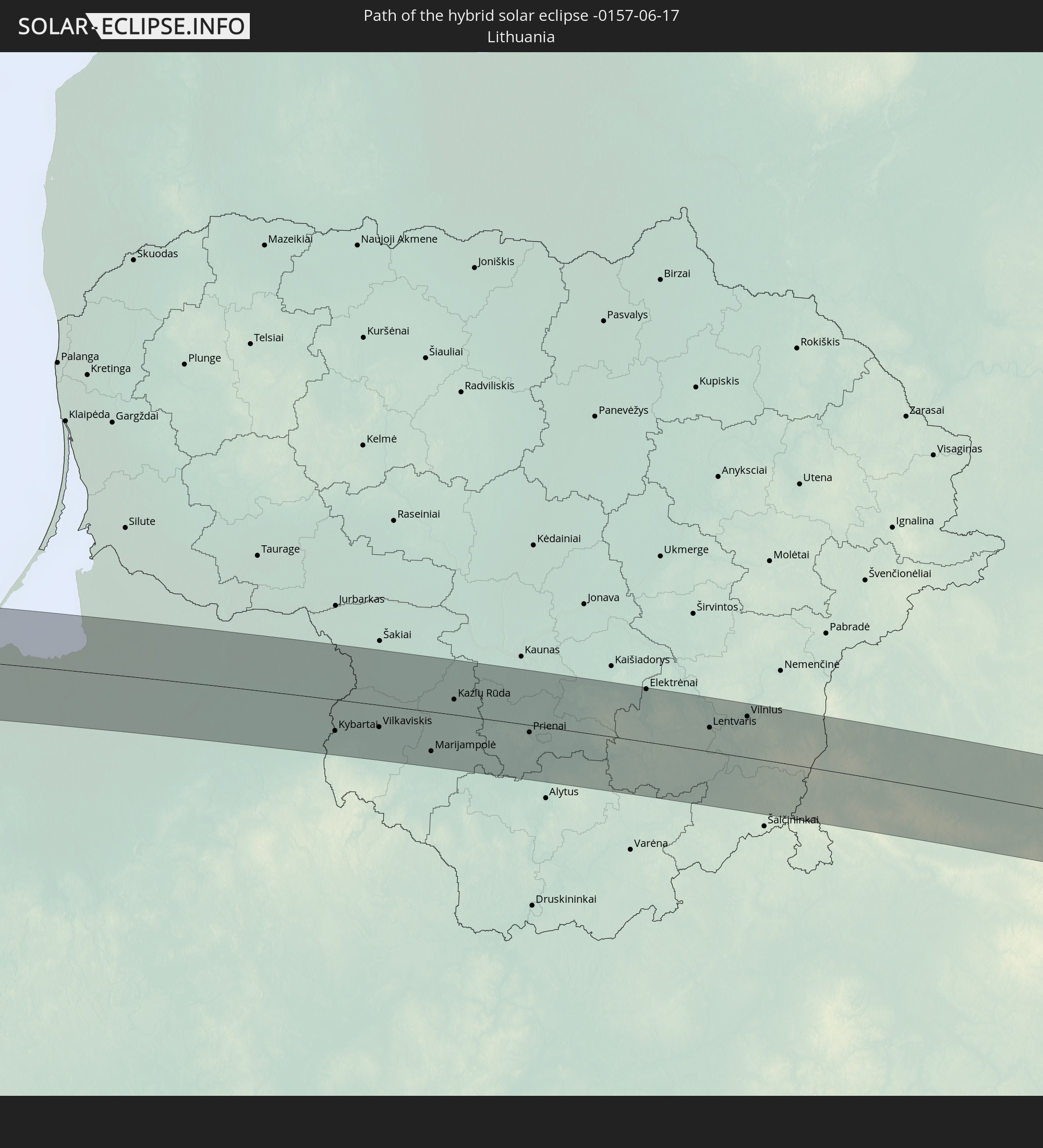
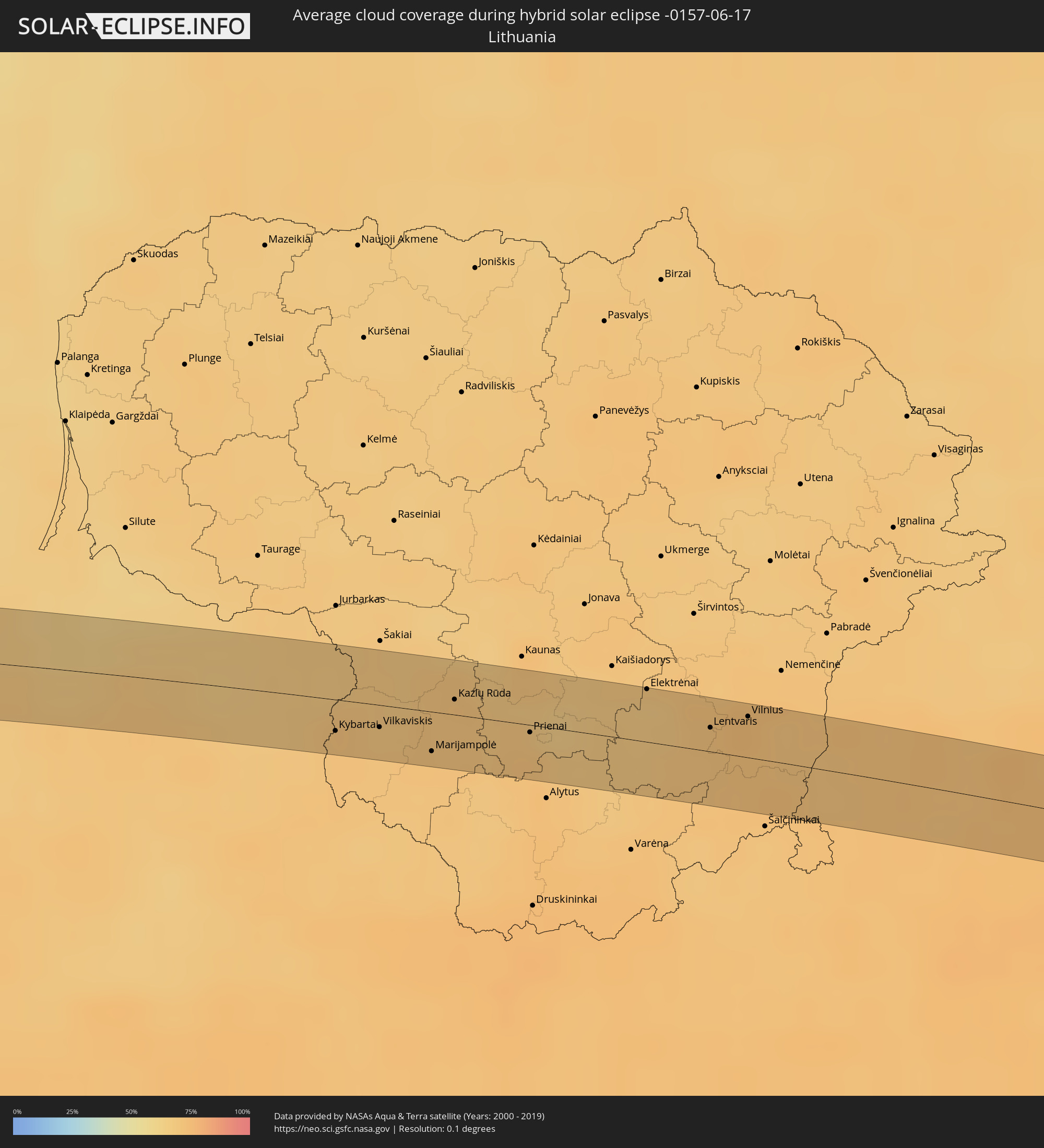 Litauen
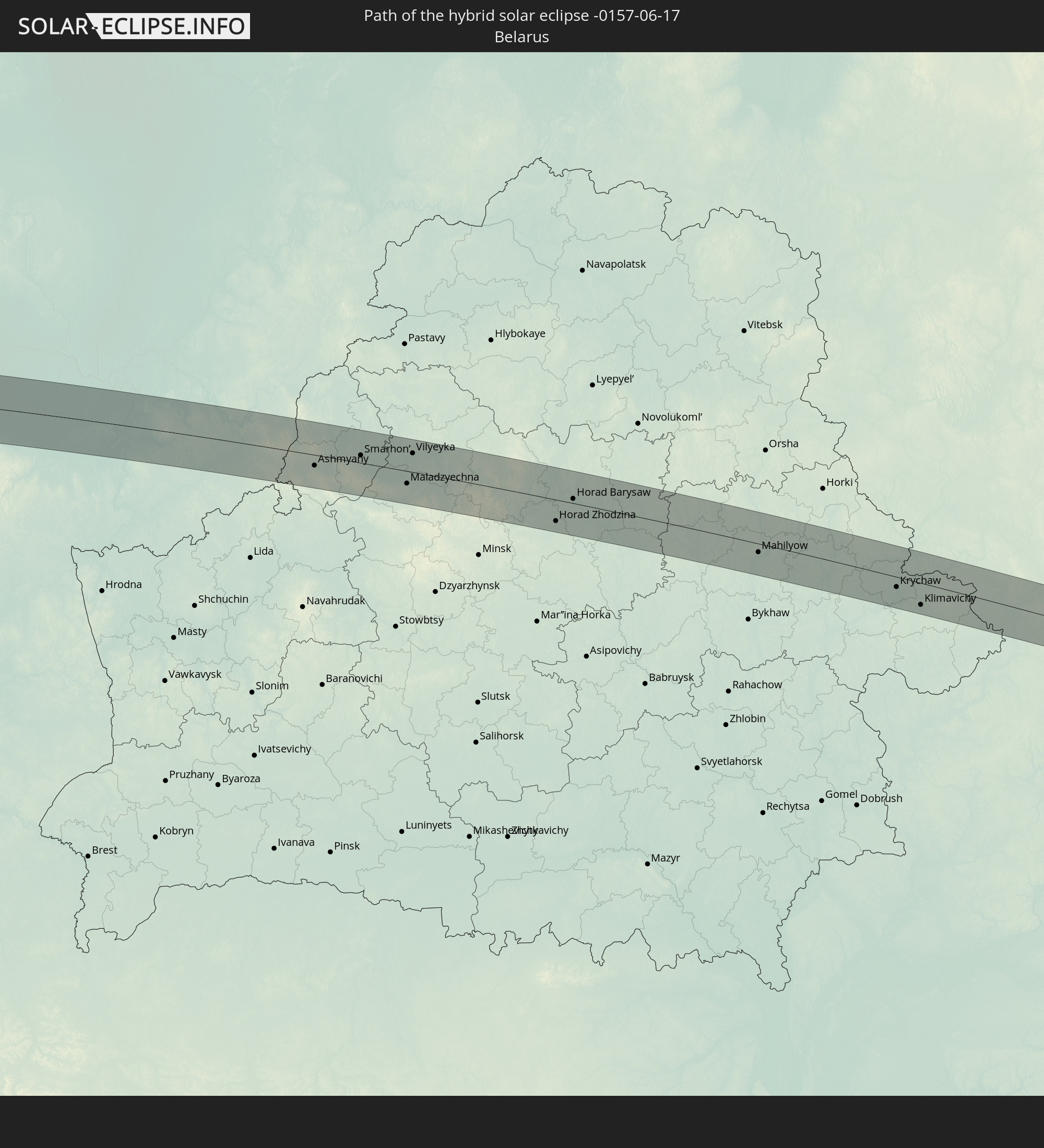
 Weißrussland
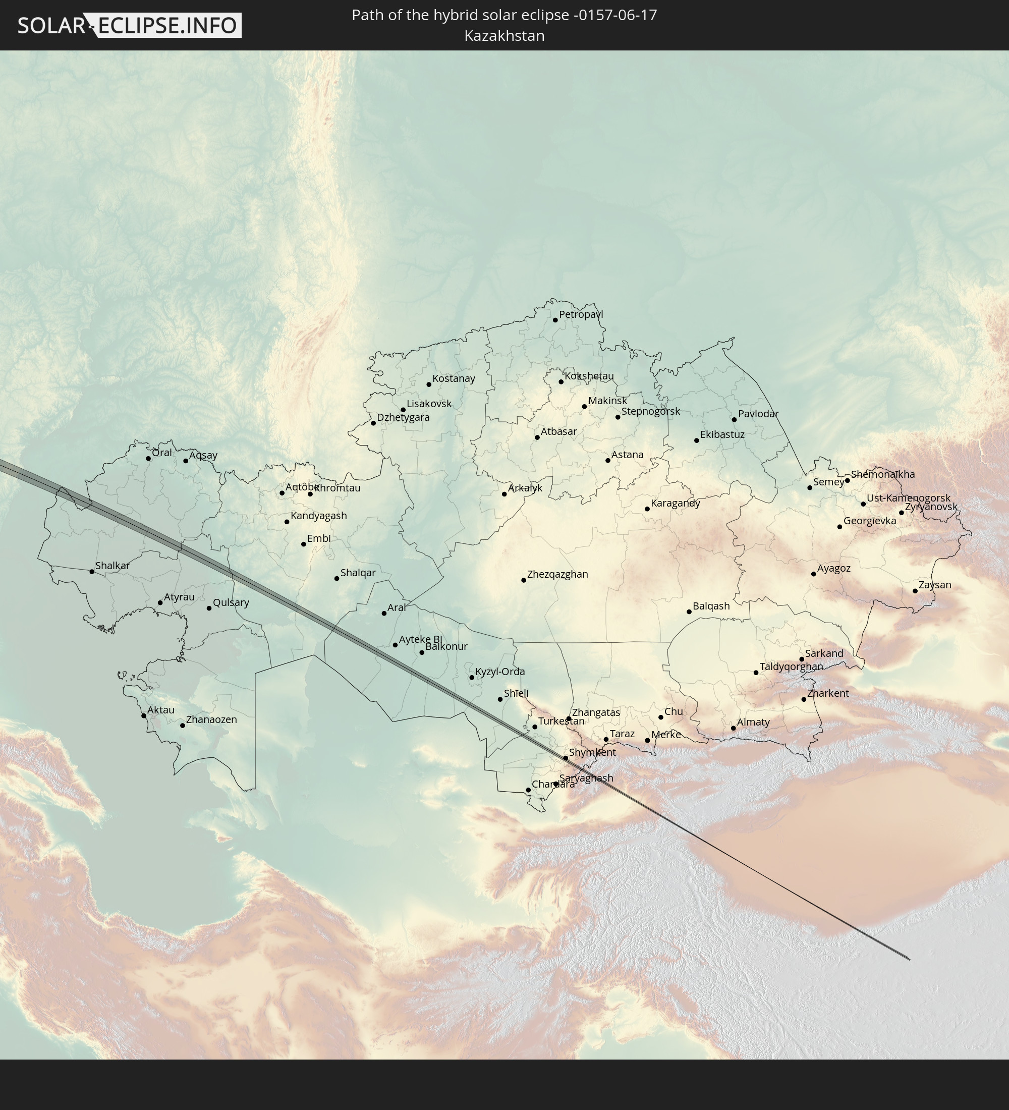
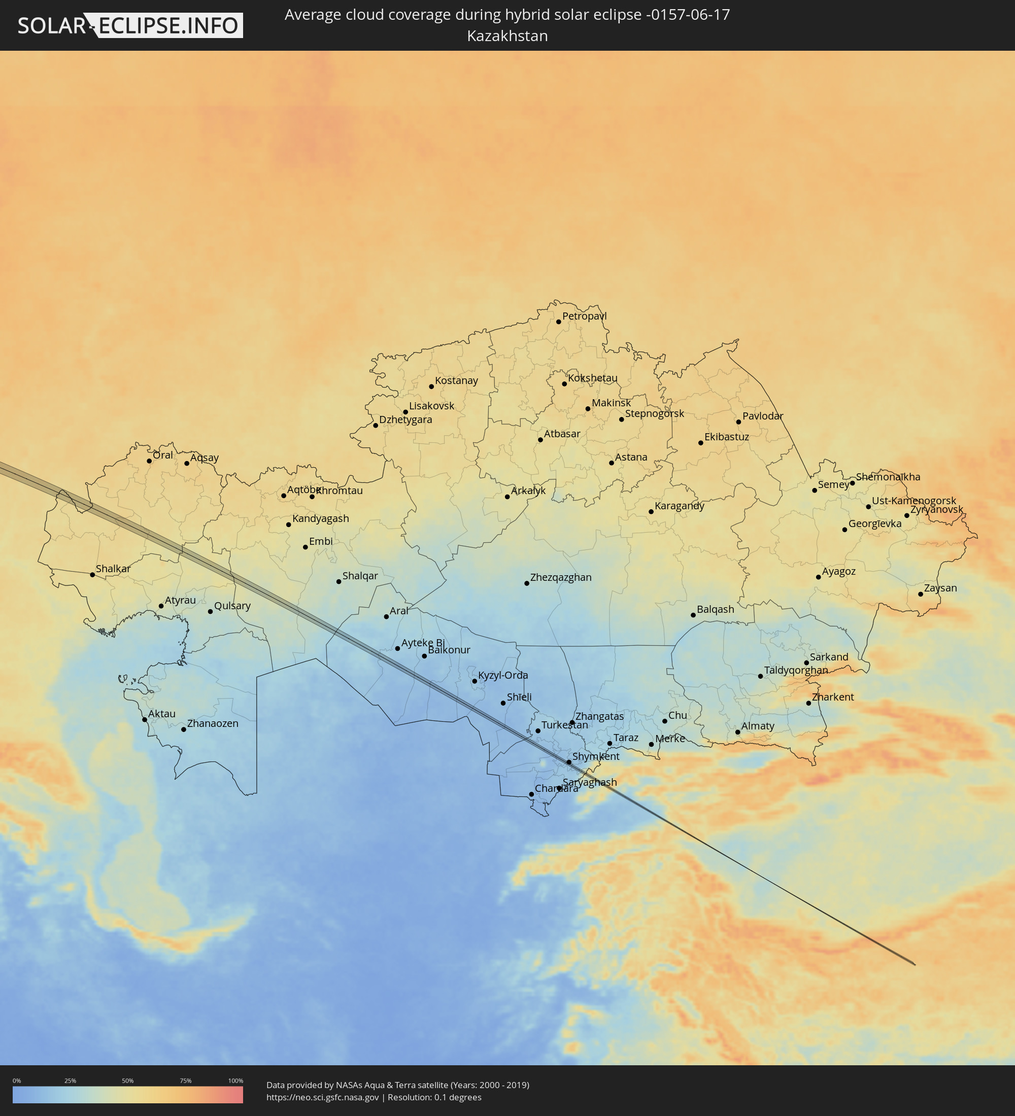 Kasachstan
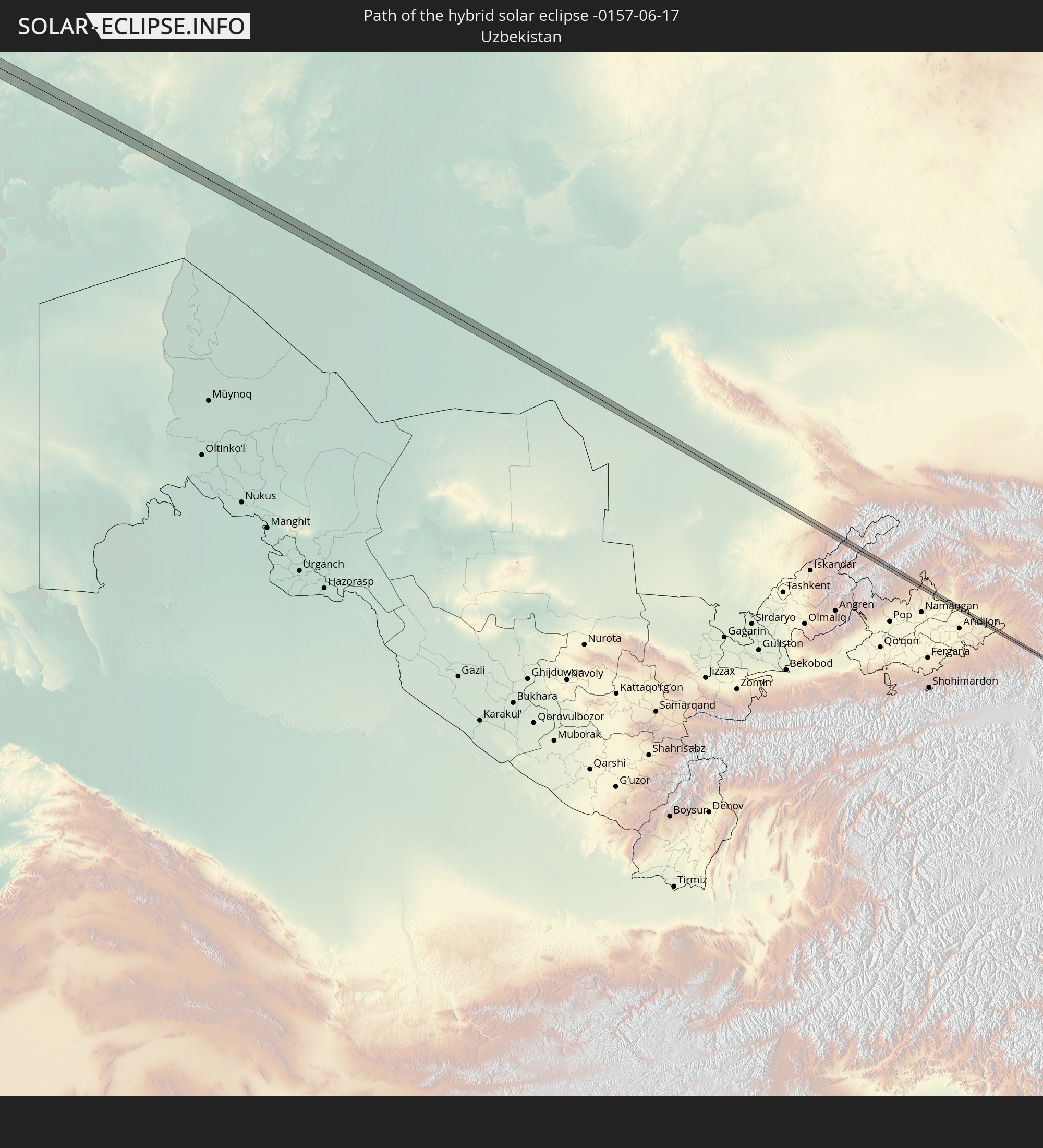
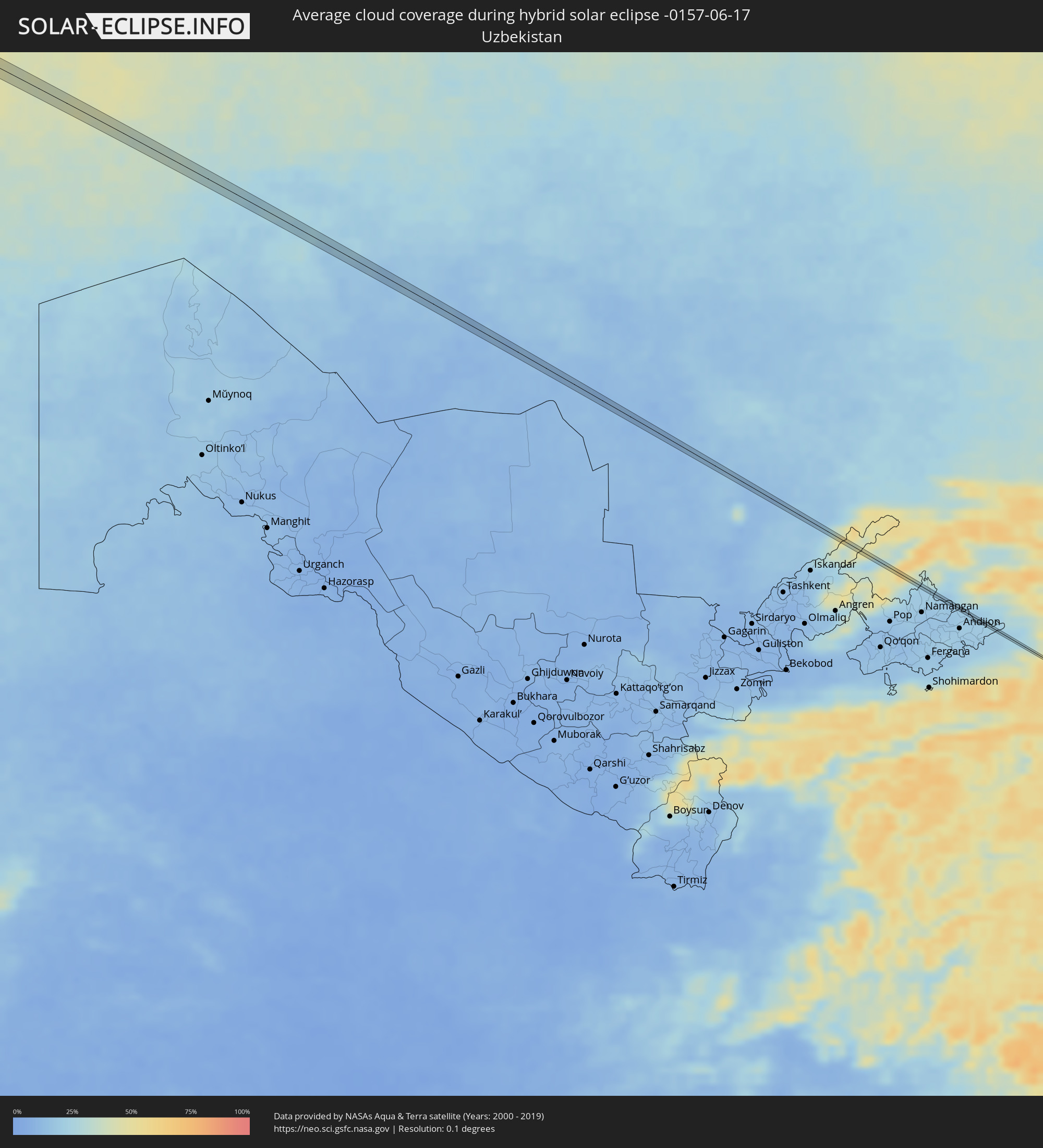 Usbekistan
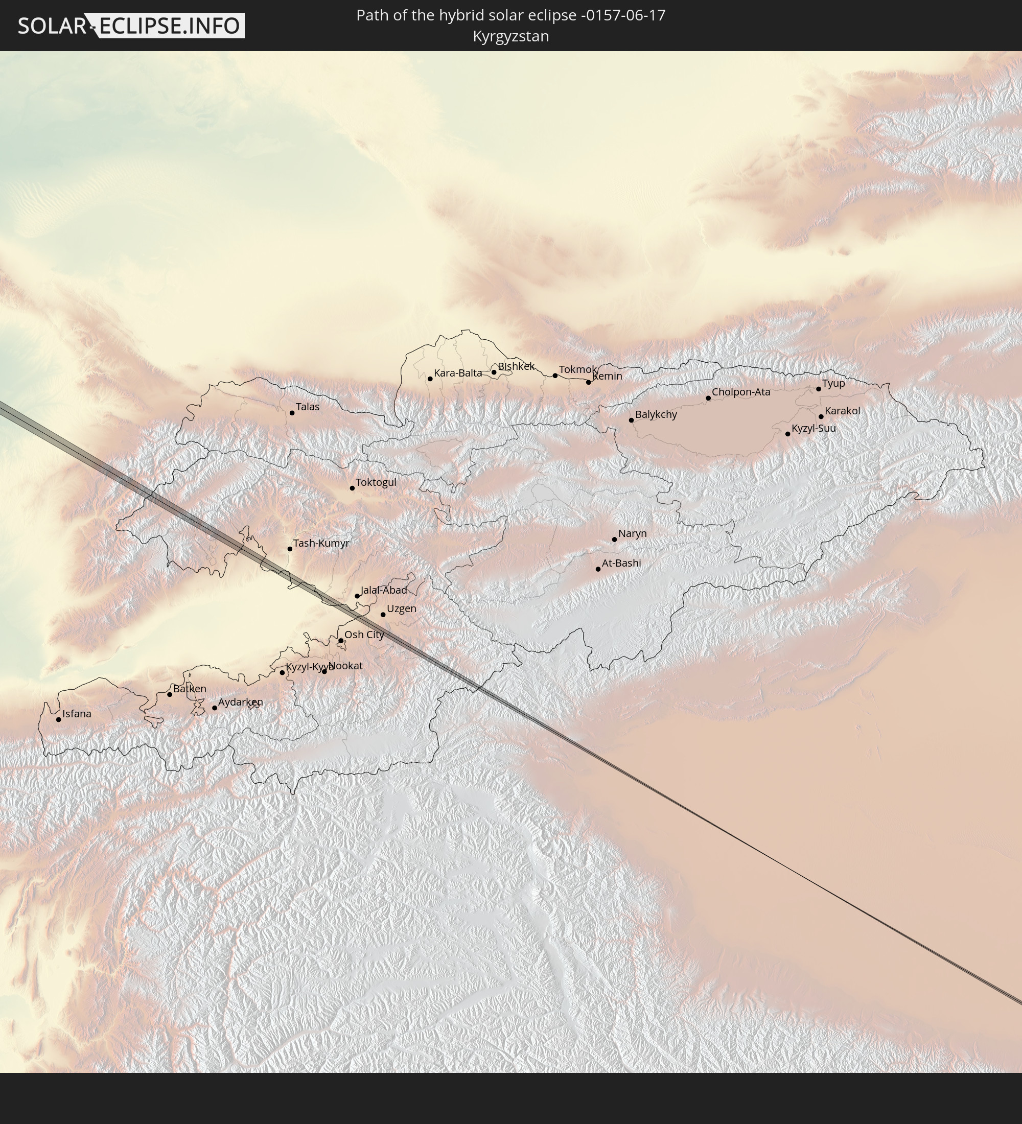
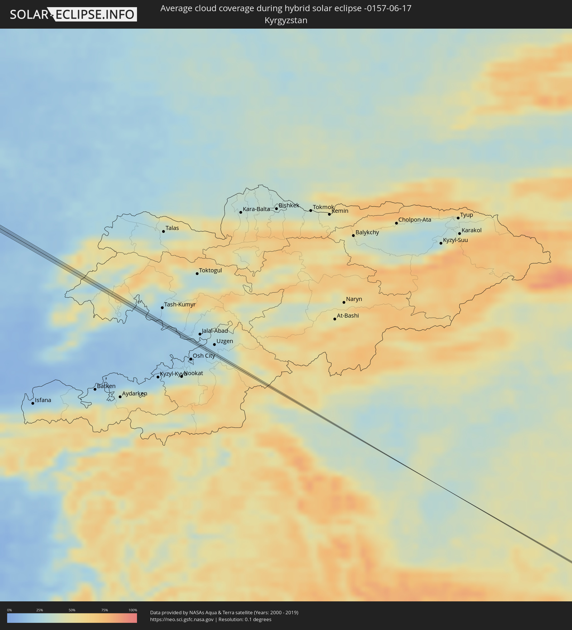 Kirgisistan
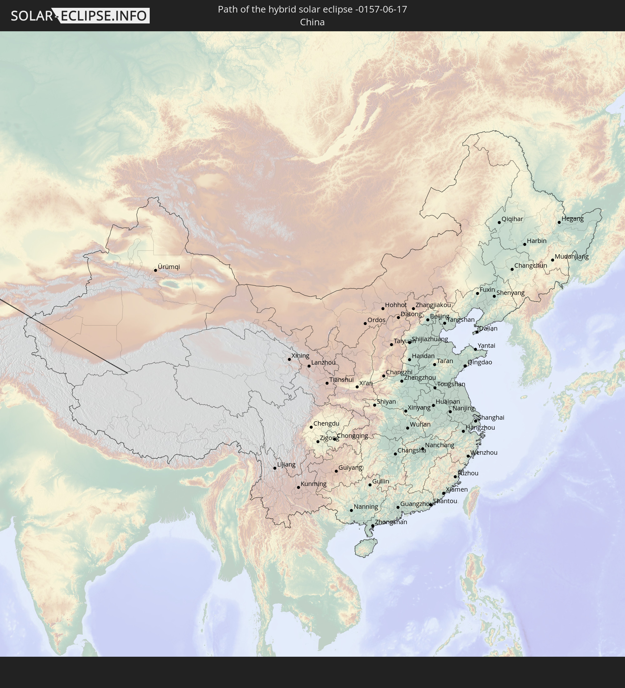
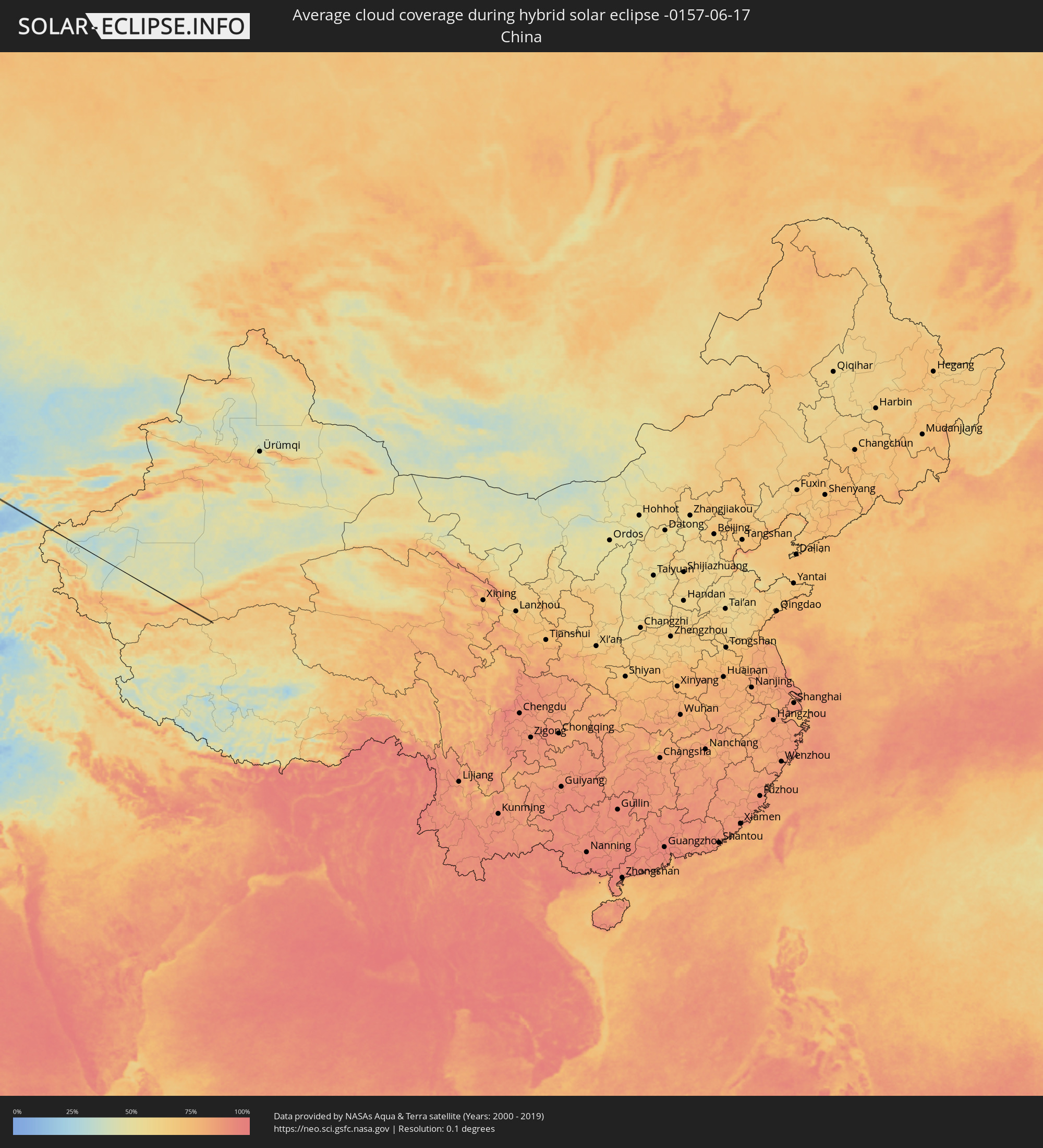 Volksrepublik China
Orte im Finsternispfad
Die nachfolgene Tabelle zeigt Städte und Orte mit mehr als 5.000 Einwohnern, die sich im Finsternispfad befinden. Städte mit mehr als 100.000 Einwohnern sind dick gekennzeichnet. Mit einem Klick auf den Ort öffnet sich eine Detailkarte die die Lage des jeweiligen Ortes zusammen mit dem Verlauf der zentralen Finsternis präsentiert.
| Ort | Typ | Dauer der Verfinsterung | Ortszeit bei maximaler Verfinsterung | Entfernung zur Zentrallinie | Ø Bewölkung |
|
Saint-Marc, Artibonite
|
ringförmig | - | 05:28:31 UTC-04:49 | 21 km | 65% |
|
Pignon, Nord
|
ringförmig | - | 05:28:31 UTC-04:49 | 13 km | 55% |
|
Ouanaminthe, Nord-Est
|
ringförmig | - | 05:28:35 UTC-04:49 | 25 km | 62% |
|
Dajabón, Dajabón
|
ringförmig | - | 05:37:35 UTC-04:40 | 23 km | 62% |
|
Las Matas de Santa Cruz, Monte Cristi
|
ringförmig | - | 05:37:38 UTC-04:40 | 5 km | 60% |
|
Tralee, Munster
|
total | - | 11:23:27 UTC-00:25 | 18 km | 79% |
|
Cill Airne, Munster
|
total | - | 11:23:31 UTC-00:25 | 13 km | 80% |
|
Newcastle West, Munster
|
total | - | 11:24:35 UTC-00:25 | 18 km | 83% |
|
Thurles, Munster
|
total | - | 11:26:43 UTC-00:25 | 21 km | 83% |
|
Kilkenny, Leinster
|
total | - | 11:27:32 UTC-00:25 | 17 km | 82% |
|
Carlow, Leinster
|
total | - | 11:28:11 UTC-00:25 | 11 km | 81% |
|
Arklow, Leinster
|
total | - | 11:29:21 UTC-00:25 | 22 km | 77% |
|
Kilquade
|
total | - | 11:29:41 UTC-00:25 | 16 km | 78% |
|
Greystones, Leinster
|
total | - | 11:29:45 UTC-00:25 | 20 km | 78% |
|
Wicklow, Leinster
|
total | - | 11:29:38 UTC-00:25 | 3 km | 77% |
|
Colwyn Bay, Wales
|
total | - | 11:58:48 UTC+00:00 | 12 km | 78% |
|
Rhyl, Wales
|
total | - | 11:59:10 UTC+00:00 | 15 km | 80% |
|
Southport, England
|
total | - | 12:00:07 UTC+00:00 | 12 km | 81% |
|
Liverpool, England
|
total | - | 12:00:01 UTC+00:00 | 15 km | 85% |
|
St Helens, England
|
total | - | 12:00:26 UTC+00:00 | 20 km | 87% |
|
Preston, England
|
total | - | 12:00:39 UTC+00:00 | 20 km | 86% |
|
Bolton, England
|
total | - | 12:00:58 UTC+00:00 | 7 km | 88% |
|
Manchester, England
|
total | - | 12:01:13 UTC+00:00 | 24 km | 88% |
|
Burnley, England
|
total | - | 12:01:24 UTC+00:00 | 18 km | 86% |
|
Rochdale, England
|
total | - | 12:01:25 UTC+00:00 | 15 km | 88% |
|
Keighley, England
|
total | - | 12:01:56 UTC+00:00 | 19 km | 84% |
|
Huddersfield, England
|
total | - | 12:02:00 UTC+00:00 | 16 km | 84% |
|
Leeds, England
|
total | - | 12:02:26 UTC+00:00 | 3 km | 85% |
|
Harrogate, England
|
total | - | 12:02:33 UTC+00:00 | 22 km | 84% |
|
Pontefract, England
|
total | - | 12:02:45 UTC+00:00 | 17 km | 86% |
|
York, England
|
total | - | 12:03:14 UTC+00:00 | 11 km | 85% |
|
Selby, England
|
total | - | 12:03:10 UTC+00:00 | 10 km | 85% |
|
Goole, England
|
total | - | 12:03:26 UTC+00:00 | 20 km | 84% |
|
Beverley, England
|
total | - | 12:04:12 UTC+00:00 | 12 km | 84% |
|
Bridlington, England
|
total | - | 12:04:39 UTC+00:00 | 15 km | 83% |
|
Westerland, Schleswig-Holstein
|
total | - | 13:17:35 UTC+01:00 | 14 km | 79% |
|
Sylt-Ost, Schleswig-Holstein
|
total | - | 13:17:45 UTC+01:00 | 6 km | 80% |
|
Niebüll, Schleswig-Holstein
|
total | - | 13:18:22 UTC+01:00 | 15 km | 76% |
|
Tønder, South Denmark
|
total | - | 13:18:25 UTC+01:00 | 10 km | 77% |
|
Leck, Schleswig-Holstein
|
total | - | 13:18:36 UTC+01:00 | 13 km | 78% |
|
Rødekro, South Denmark
|
total | - | 13:19:03 UTC+01:00 | 22 km | 77% |
|
Handewitt, Schleswig-Holstein
|
total | - | 13:19:07 UTC+01:00 | 19 km | 77% |
|
Harrislee, Schleswig-Holstein
|
total | - | 13:19:11 UTC+01:00 | 14 km | 77% |
|
Aabenraa, South Denmark
|
total | - | 13:19:12 UTC+01:00 | 16 km | 76% |
|
Flensburg, Schleswig-Holstein
|
total | - | 13:19:16 UTC+01:00 | 14 km | 77% |
|
Glücksburg, Schleswig-Holstein
|
total | - | 13:19:25 UTC+01:00 | 9 km | 78% |
|
Nordborg, South Denmark
|
total | - | 13:19:40 UTC+01:00 | 22 km | 74% |
|
Sønderborg, South Denmark
|
total | - | 13:19:47 UTC+01:00 | 13 km | 77% |
|
Faaborg, South Denmark
|
total | - | 13:20:23 UTC+01:00 | 23 km | 75% |
|
Svendborg, South Denmark
|
total | - | 13:20:55 UTC+01:00 | 14 km | 74% |
|
Nakskov, Zealand
|
total | - | 13:21:43 UTC+01:00 | 17 km | 71% |
|
Vordingborg, Zealand
|
total | - | 13:22:48 UTC+01:00 | 6 km | 70% |
|
Rønne, Capital Region
|
total | - | 13:26:42 UTC+01:00 | 15 km | 64% |
|
Władysławowo, Pomeranian Voivodeship
|
total | - | 13:55:55 UTC+01:24 | 21 km | 70% |
|
Svetlogorsk, Kaliningrad
|
total | - | 13:34:07 UTC+01:00 | 10 km | 64% |
|
Pionerskiy, Kaliningrad
|
total | - | 13:34:13 UTC+01:00 | 15 km | 64% |
|
Zelenogradsk, Kaliningrad
|
total | - | 13:34:32 UTC+01:00 | 8 km | 65% |
|
Kaliningrad, Kaliningrad
|
total | - | 13:34:46 UTC+01:00 | 20 km | 66% |
|
Chernyakhovsk, Kaliningrad
|
total | - | 13:36:30 UTC+01:00 | 22 km | 69% |
|
Gusev, Kaliningrad
|
total | - | 13:37:01 UTC+01:00 | 26 km | 68% |
|
Kybartai
|
total | - | 14:01:41 UTC+01:24 | 18 km | 71% |
|
Vilkaviskis
|
total | - | 14:02:01 UTC+01:24 | 9 km | 69% |
|
Marijampolė, Marijampolė County
|
total | - | 14:02:29 UTC+01:24 | 17 km | 70% |
|
Kazlų Rūda, Marijampolė County
|
total | - | 14:02:30 UTC+01:24 | 6 km | 70% |
|
Garliava, Kaunas County
|
total | - | 14:02:54 UTC+01:24 | 20 km | 67% |
|
Prienai
|
total | - | 14:03:10 UTC+01:24 | 4 km | 71% |
|
Elektrėnai, Vilnius County
|
total | - | 14:03:54 UTC+01:24 | 22 km | 66% |
|
Trakai
|
total | - | 14:04:22 UTC+01:24 | 9 km | 70% |
|
Lentvaris, Vilnius County
|
total | - | 14:04:29 UTC+01:24 | 9 km | 72% |
|
Grigiškės
|
total | - | 14:04:30 UTC+01:24 | 14 km | 72% |
|
Pilaitė, Vilnius County
|
total | - | 14:04:36 UTC+01:24 | 19 km | 74% |
|
Lazdynai, Vilnius County
|
total | - | 14:04:39 UTC+01:24 | 17 km | 74% |
|
Justiniškės, Vilnius County
|
total | - | 14:04:37 UTC+01:24 | 21 km | 74% |
|
Pašilaičiai, Vilnius County
|
total | - | 14:04:36 UTC+01:24 | 23 km | 74% |
|
Fabijoniškės, Vilnius County
|
total | - | 14:04:38 UTC+01:24 | 24 km | 74% |
|
Vilkpėdė, Vilnius County
|
total | - | 14:04:42 UTC+01:24 | 19 km | 74% |
|
Šeškinė, Vilnius County
|
total | - | 14:04:40 UTC+01:24 | 22 km | 73% |
|
Naujamiestis, Vilnius County
|
total | - | 14:04:43 UTC+01:24 | 21 km | 73% |
|
Vilnius, Vilnius County
|
total | - | 14:04:43 UTC+01:24 | 22 km | 73% |
|
Rasos, Vilnius County
|
total | - | 14:04:46 UTC+01:24 | 21 km | 73% |
|
Ashmyany, Grodnenskaya
|
total | - | 14:31:46 UTC+01:50 | 7 km | 71% |
|
Astravyets, Grodnenskaya
|
total | - | 14:31:36 UTC+01:50 | 16 km | 72% |
|
Smarhon’, Grodnenskaya
|
total | - | 14:32:15 UTC+01:50 | 9 km | 71% |
|
Maladzyechna, Minsk
|
total | - | 14:32:57 UTC+01:50 | 11 km | 72% |
|
Vilyeyka, Minsk
|
total | - | 14:32:50 UTC+01:50 | 14 km | 73% |
|
Chyst’, Minsk
|
total | - | 14:33:17 UTC+01:50 | 13 km | 72% |
|
Plyeshchanitsy, Minsk
|
total | - | 14:33:58 UTC+01:50 | 21 km | 73% |
|
Lahoysk, Minsk
|
total | - | 14:34:13 UTC+01:50 | 11 km | 72% |
|
Horad Zhodzina, Minsk
|
total | - | 14:34:53 UTC+01:50 | 16 km | 73% |
|
Horad Barysaw, Minsk
|
total | - | 14:34:56 UTC+01:50 | 3 km | 72% |
|
Loshnitsa, Minsk
|
total | - | 14:35:10 UTC+01:50 | 19 km | 70% |
|
Byalynichy, Mogilev
|
total | - | 14:36:32 UTC+01:50 | 17 km | 72% |
|
Mahilyow, Mogilev
|
total | - | 14:37:19 UTC+01:50 | 11 km | 72% |
|
Chavusy, Mogilev
|
total | - | 14:38:07 UTC+01:50 | 8 km | 71% |
|
Krychaw, Mogilev
|
total | - | 14:39:01 UTC+01:50 | 18 km | 69% |
|
Klimavichy, Mogilev
|
total | - | 14:39:24 UTC+01:50 | 14 km | 71% |
|
Kletnya, Brjansk
|
total | - | 15:21:15 UTC+02:30 | 22 km | 70% |
|
Zhukovka, Brjansk
|
total | - | 15:21:35 UTC+02:30 | 16 km | 68% |
|
Sel’tso, Brjansk
|
total | - | 15:22:10 UTC+02:30 | 8 km | 71% |
|
Bryansk, Brjansk
|
total | - | 15:22:34 UTC+02:30 | 12 km | 73% |
|
Belyye Berega, Brjansk
|
total | - | 15:22:55 UTC+02:30 | 17 km | 72% |
|
Karachev, Brjansk
|
total | - | 15:23:20 UTC+02:30 | 13 km | 69% |
|
Orël, Orjol
|
total | - | 15:24:35 UTC+02:30 | 8 km | 72% |
|
Yelets, Lipetsk
|
total | - | 15:27:15 UTC+02:30 | 6 km | 71% |
|
Zadonsk, Lipetsk
|
total | - | 15:27:56 UTC+02:30 | 9 km | 70% |
|
Dobrinka, Lipetsk
|
total | - | 15:29:33 UTC+02:30 | 4 km | 67% |
|
Zherdevka, Tambov
|
total | - | 15:30:48 UTC+02:30 | 7 km | 65% |
|
Balashov, Saratov
|
total | - | 16:22:35 UTC+03:20 | 12 km | 64% |
|
Zhirnovsk, Volgograd
|
total | - | 15:34:31 UTC+02:30 | 17 km | 60% |
|
Aleksandrov Gay, Saratov
|
total | - | 16:28:14 UTC+03:20 | 11 km | 56% |