Totale Sonnenfinsternis vom 24.07.-0345
| Wochentag: | Donnerstag |
| Maximale Dauer der Verfinsterung: | 04m44s |
| Maximale Breite des Finsternispfades: | 229 km |
| Saroszyklus: | 69 |
| Bedeckungsgrad: | 100% |
| Magnitude: | 1.0621 |
| Gamma: | 0.4502 |
Wo kann man die Sonnenfinsternis vom 24.07.-0345 sehen?
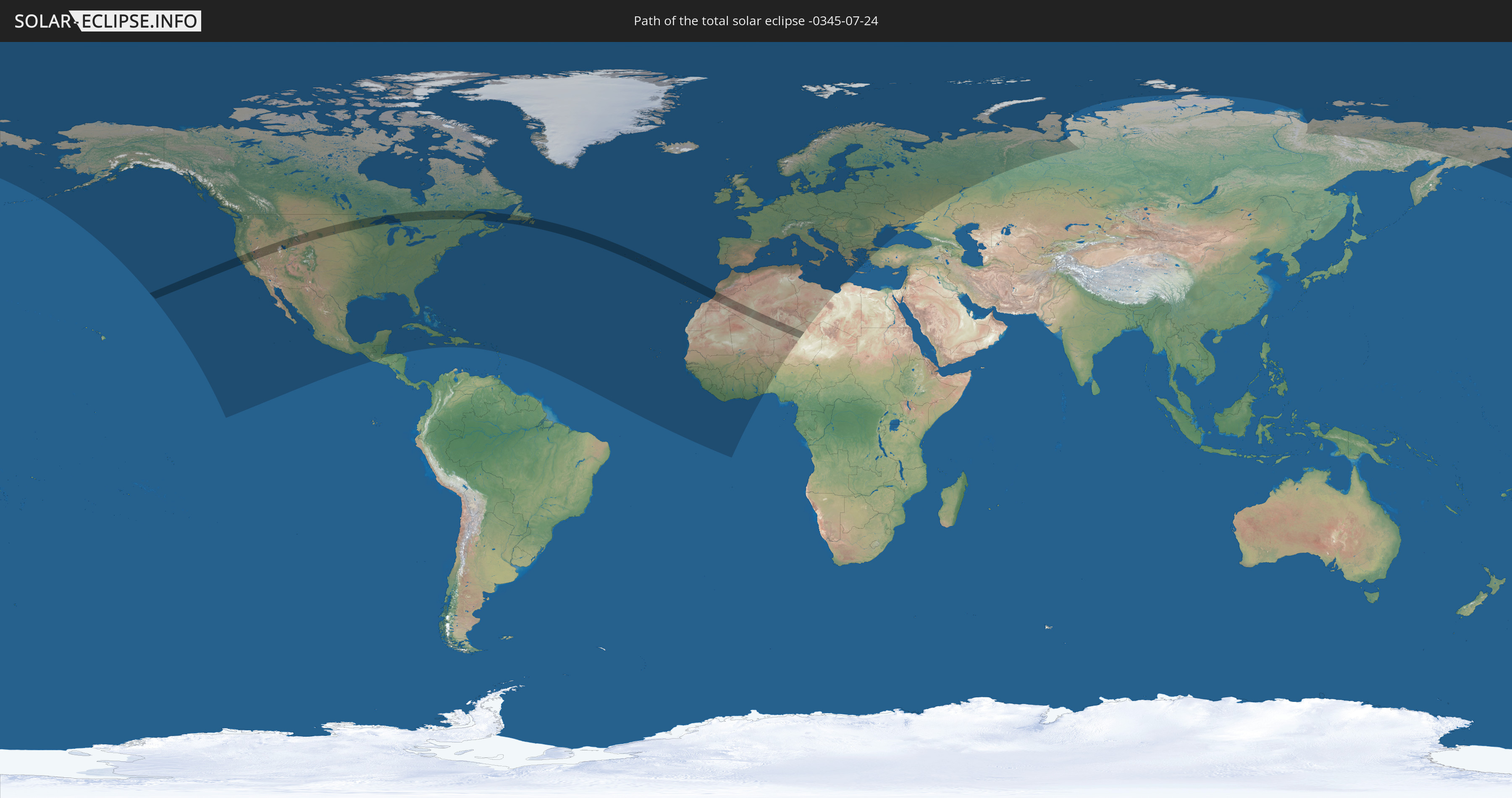
Die Sonnenfinsternis am 24.07.-0345 kann man in 99 Ländern als partielle Sonnenfinsternis beobachten.
Der Finsternispfad verläuft durch 7 Länder. Nur in diesen Ländern ist sie als totale Sonnenfinsternis zu sehen.
In den folgenden Ländern ist die Sonnenfinsternis total zu sehen
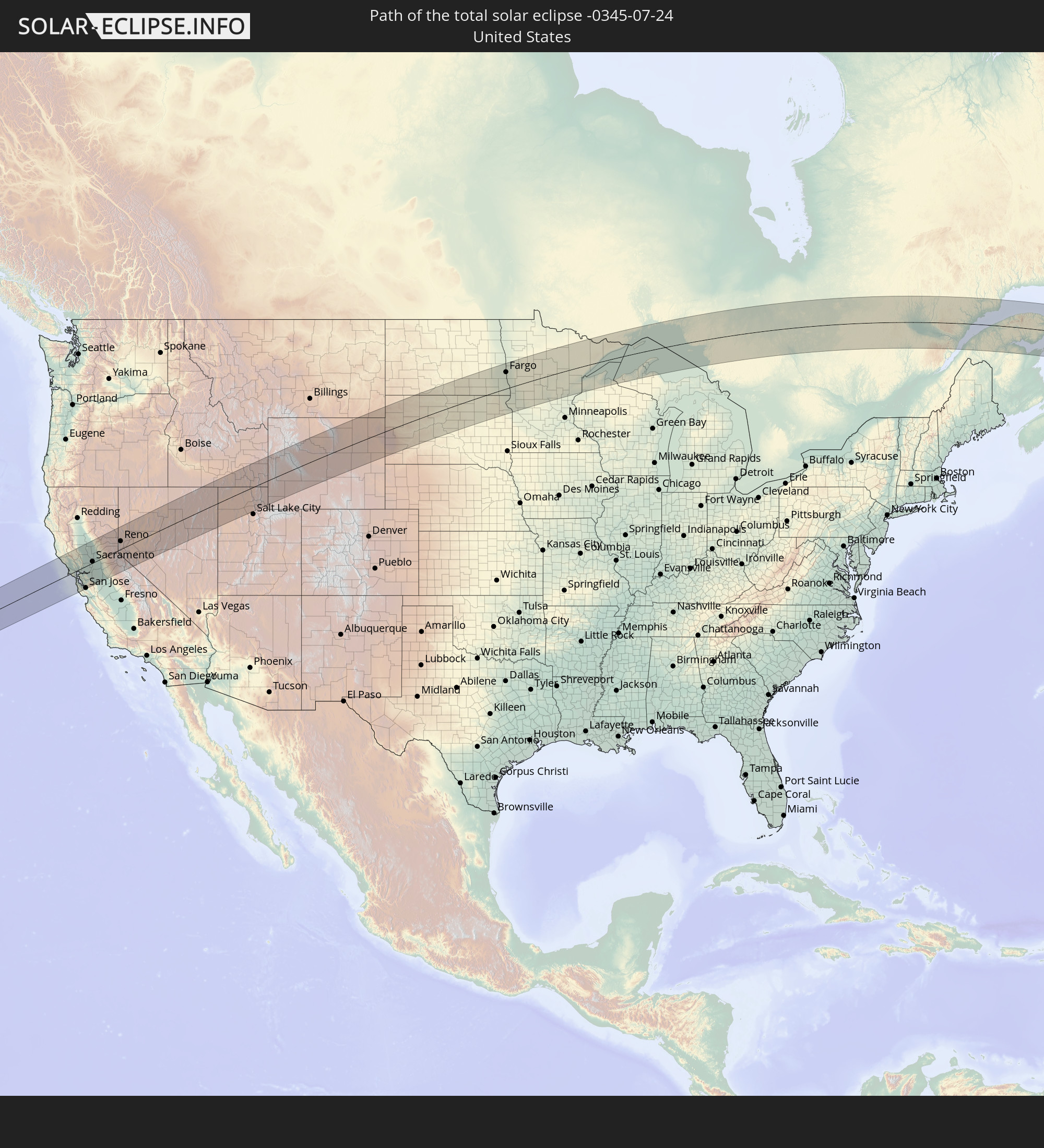 Vereinigte Staaten
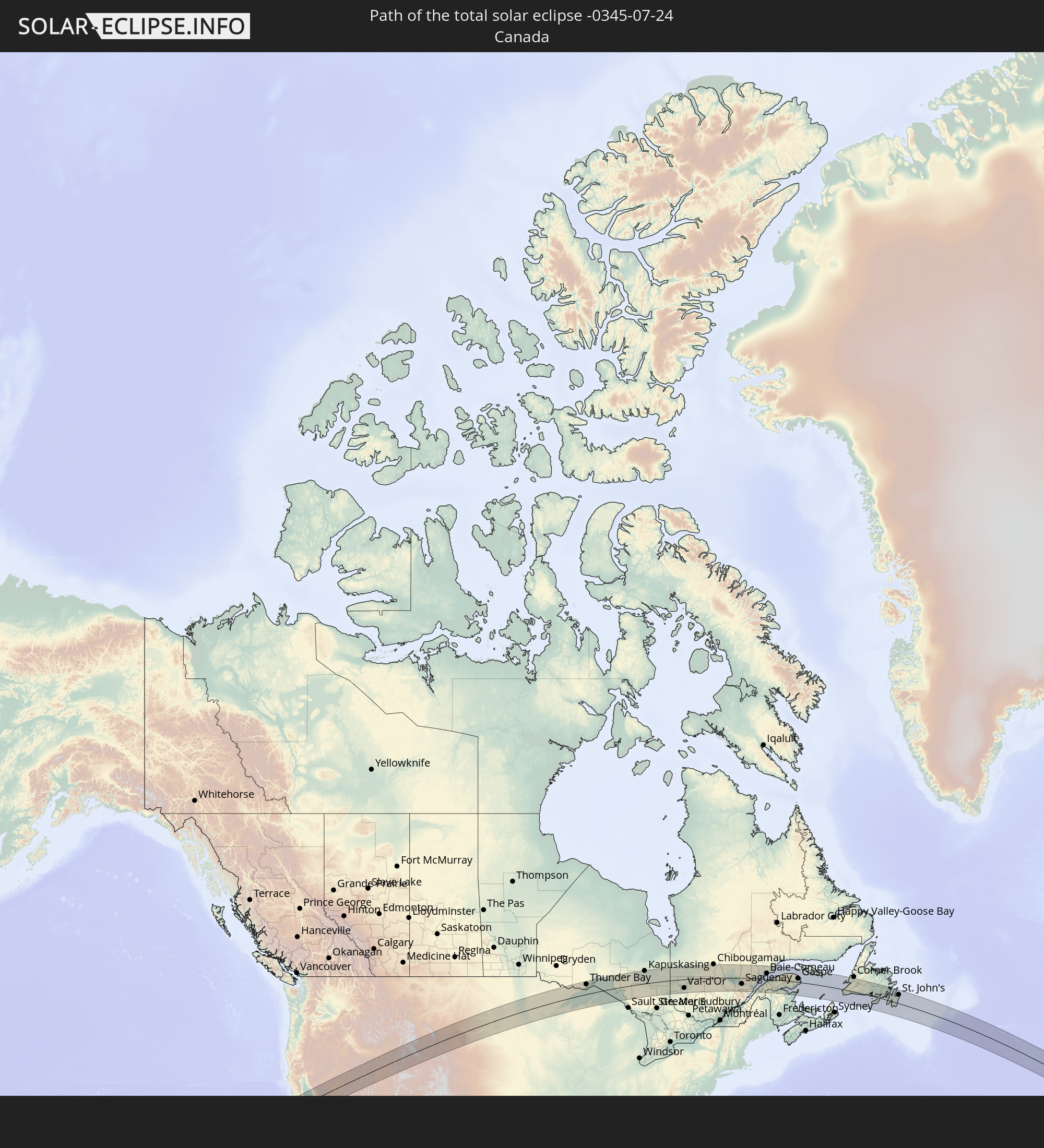 Kanada
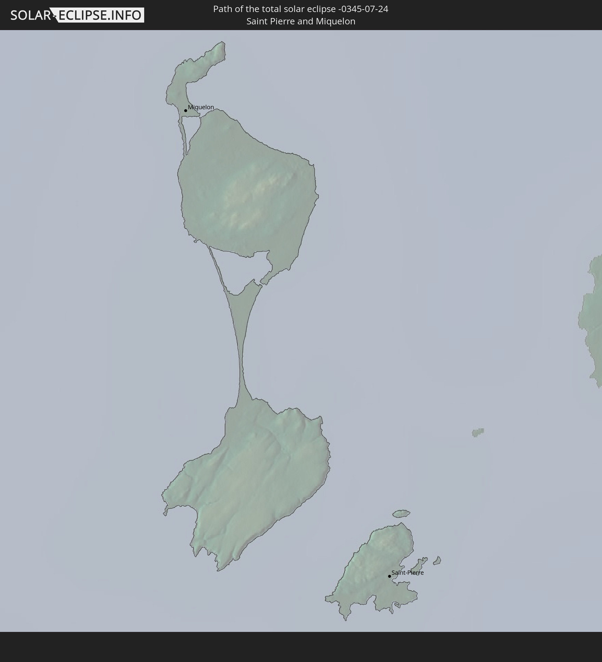 Saint-Pierre und Miquelon
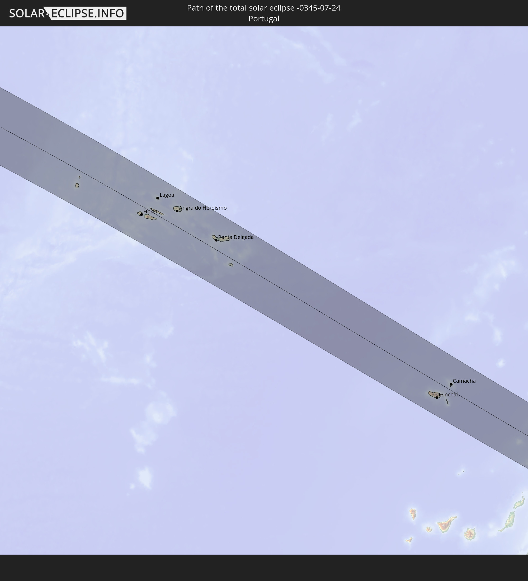 Portugal
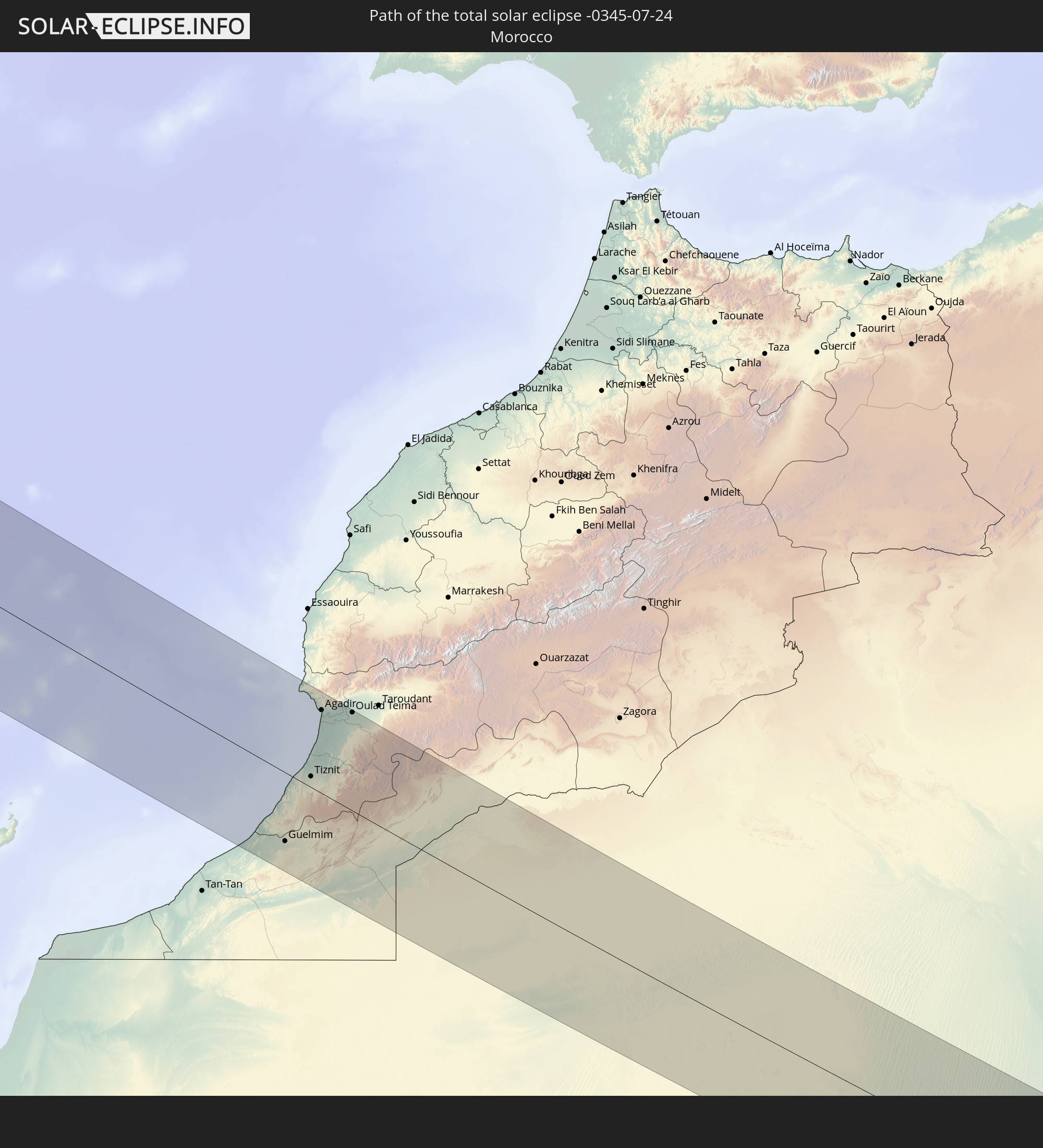 Marokko
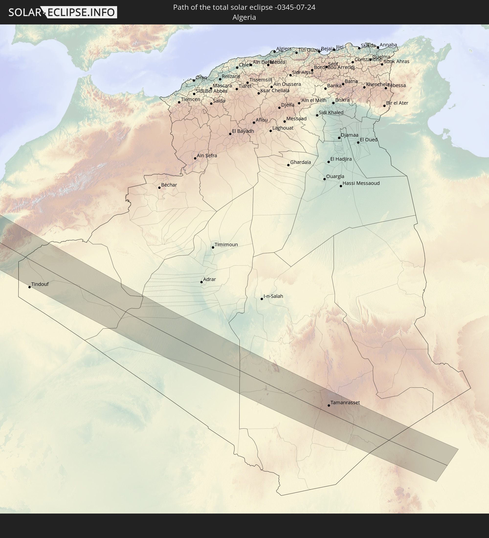 Algerien
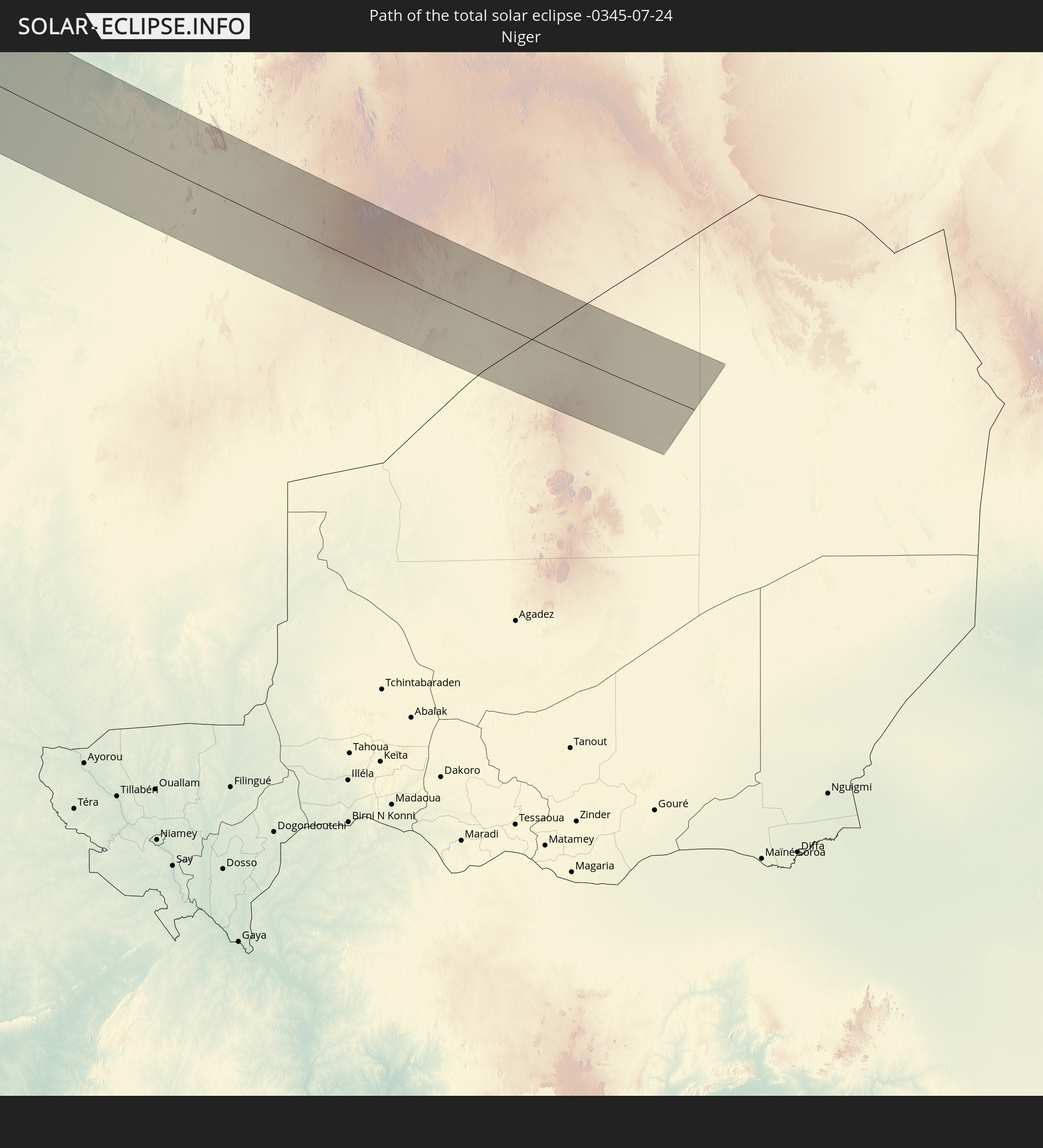 Niger
Niger
In den folgenden Ländern ist die Sonnenfinsternis partiell zu sehen
 Russland
 Vereinigte Staaten
 United States Minor Outlying Islands
 Kanada
 Mexiko
 Grönland
 Guatemala
 Honduras
 Belize
 Kuba
Kuba
 Kaimaninseln
 Bahamas
 Jamaika
 Haiti
Haiti
 Turks- und Caicosinseln
 Dominikanische Republik
 Puerto Rico
 Amerikanische Jungferninseln
 Bermuda
 Britische Jungferninseln
 Anguilla
 Saint-Martin
 Saint-Barthélemy
 St. Kitts und Nevis
 Antigua und Barbuda
 Montserrat
 Guadeloupe
 Saint-Pierre und Miquelon
 Portugal
 Kap Verde
 Island
 Spanien
 Senegal
 Mauretanien
 Gambia
 Guinea-Bissau
 Guinea
 Sierra Leone
 Marokko
 Mali
Mali
 Liberia
 Irland
 Spitzbergen
 Algerien
 Vereinigtes Königreich
 Elfenbeinküste
 Färöer
 Burkina Faso
 Gibraltar
 Frankreich
 Isle of Man
 Ghana
Ghana
 Guernsey
 Jersey
 Togo
Togo
 Niger
Niger
 Benin
Benin
 Andorra
 Belgien
 Nigeria
 Niederlande
 Norwegen
 Luxemburg
 Deutschland
 Schweiz
 Italien
 Monaco
 Tunesien
 Dänemark
 Libyen
 Liechtenstein
 Österreich
 Schweden
 Tschechien
 San Marino
 Vatikanstadt
 Slowenien
 Kroatien
 Polen
Polen
 Malta
Malta
 Bosnien und Herzegowina
 Ungarn
 Slowakei
 Montenegro
 Serbien
 Albanien
 Åland Islands
 Griechenland
 Rumänien
 Mazedonien
 Finnland
 Litauen
 Lettland
 Estland
 Ukraine
 Bulgarien
 Weißrussland
 Türkei
 Moldawien
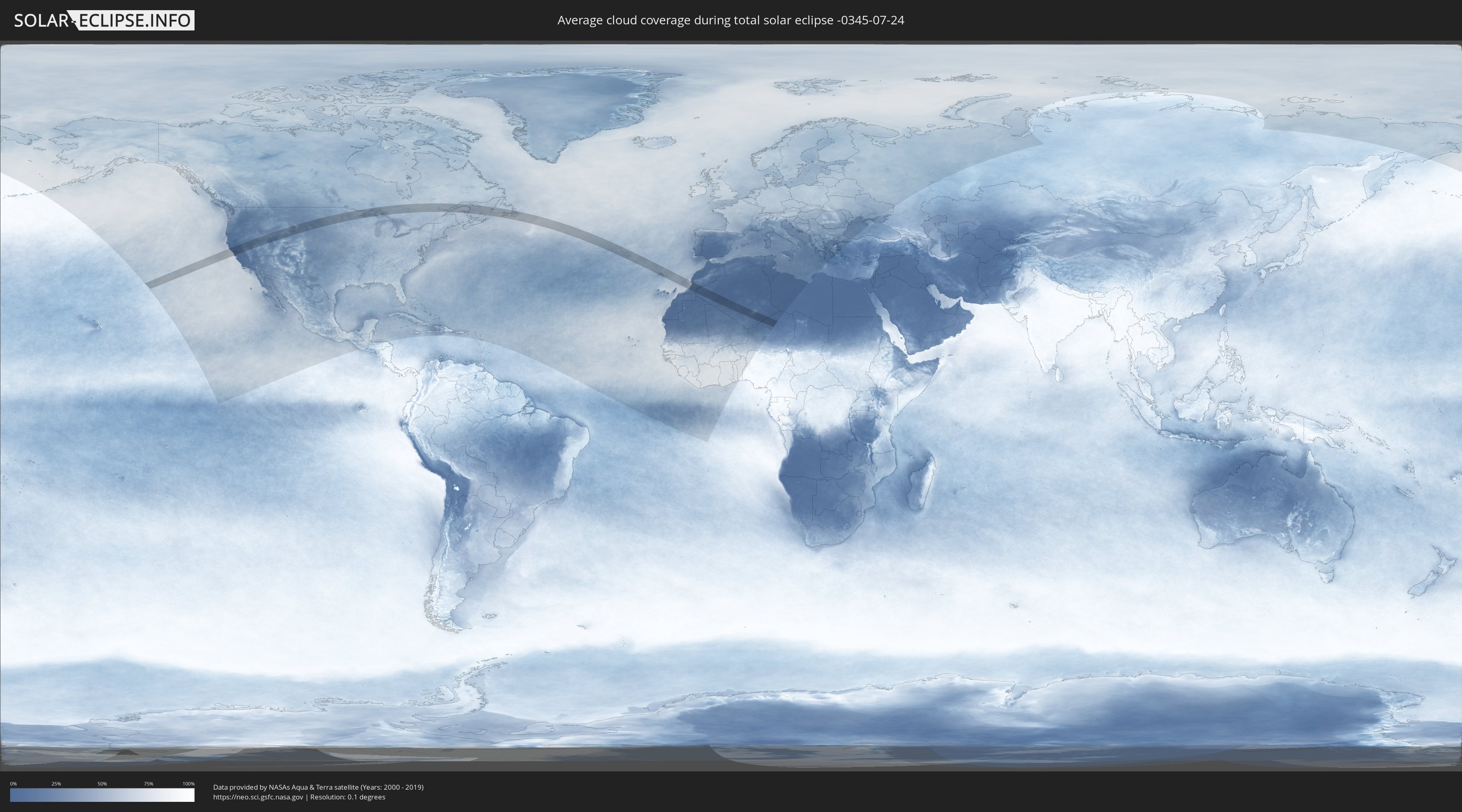
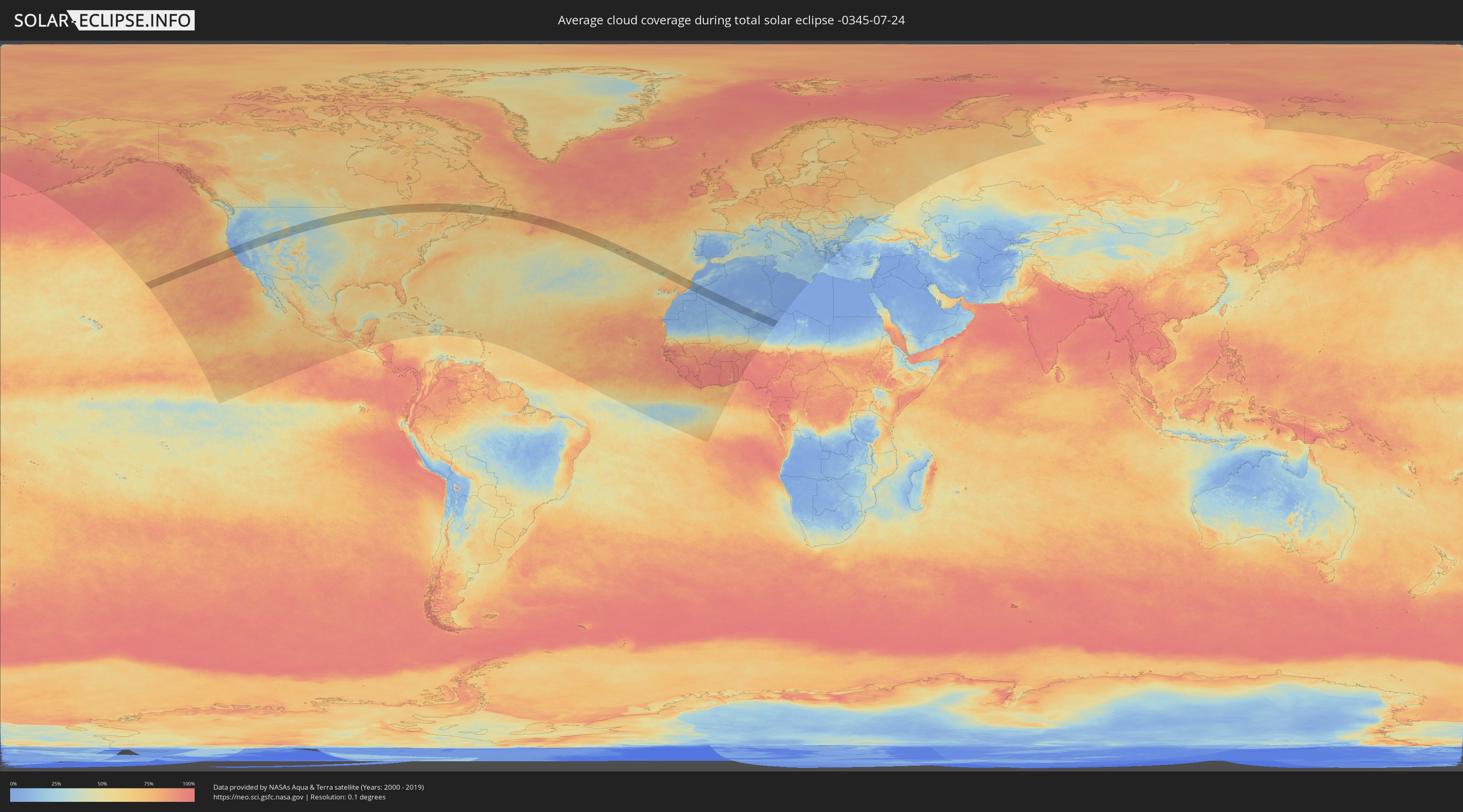
Wie wird das Wetter während der totalen Sonnenfinsternis am 24.07.-0345?
Wo ist der beste Ort, um die totale Sonnenfinsternis vom 24.07.-0345 zu beobachten?
Die folgenden Karten zeigen die durchschnittliche Bewölkung für den Tag, an dem die totale Sonnenfinsternis
stattfindet. Mit Hilfe der Karten lässt sich der Ort entlang des Finsternispfades eingrenzen,
der die besten Aussichen auf einen klaren wolkenfreien Himmel bietet.
Trotzdem muss man immer lokale Gegenenheiten beachten und sollte sich genau über das Wetter an seinem
gewählten Beobachtungsort informieren.
Die Daten stammen von den beiden NASA-Satelliten
AQUA und TERRA
und wurden über einen Zeitraum von 19 Jahren (2000 - 2019) gemittelt.
Detaillierte Länderkarten
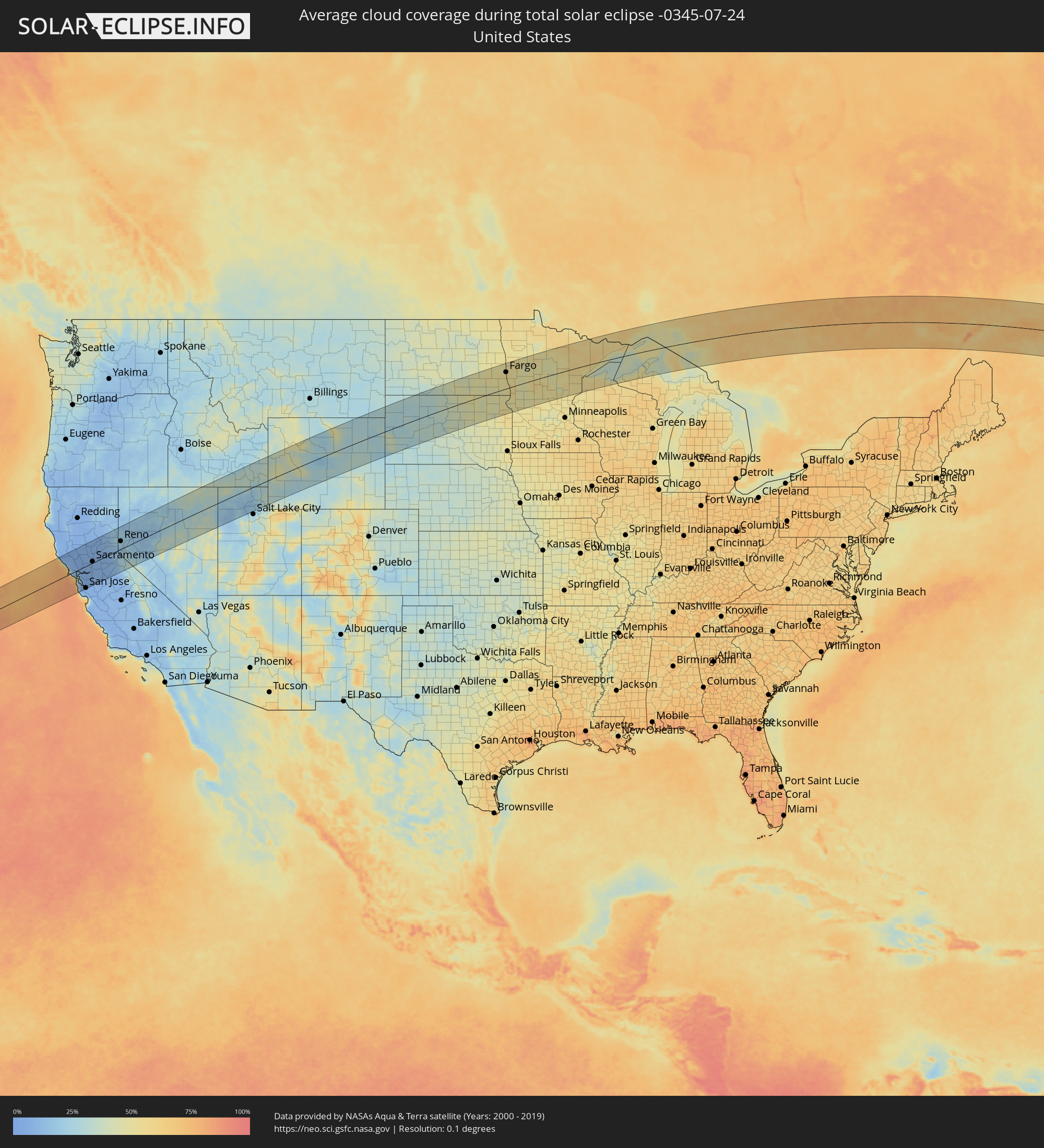 Vereinigte Staaten
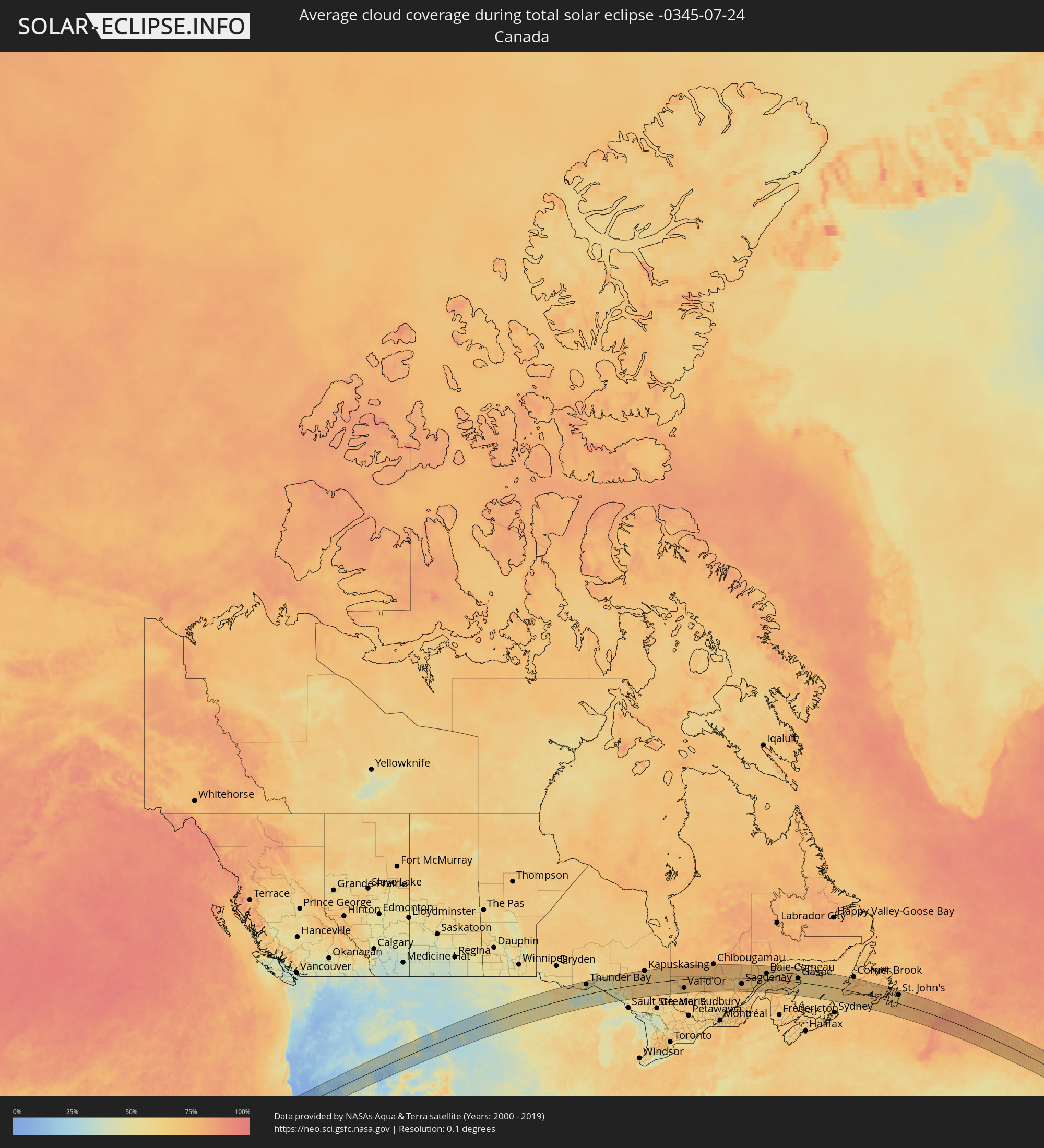 Kanada
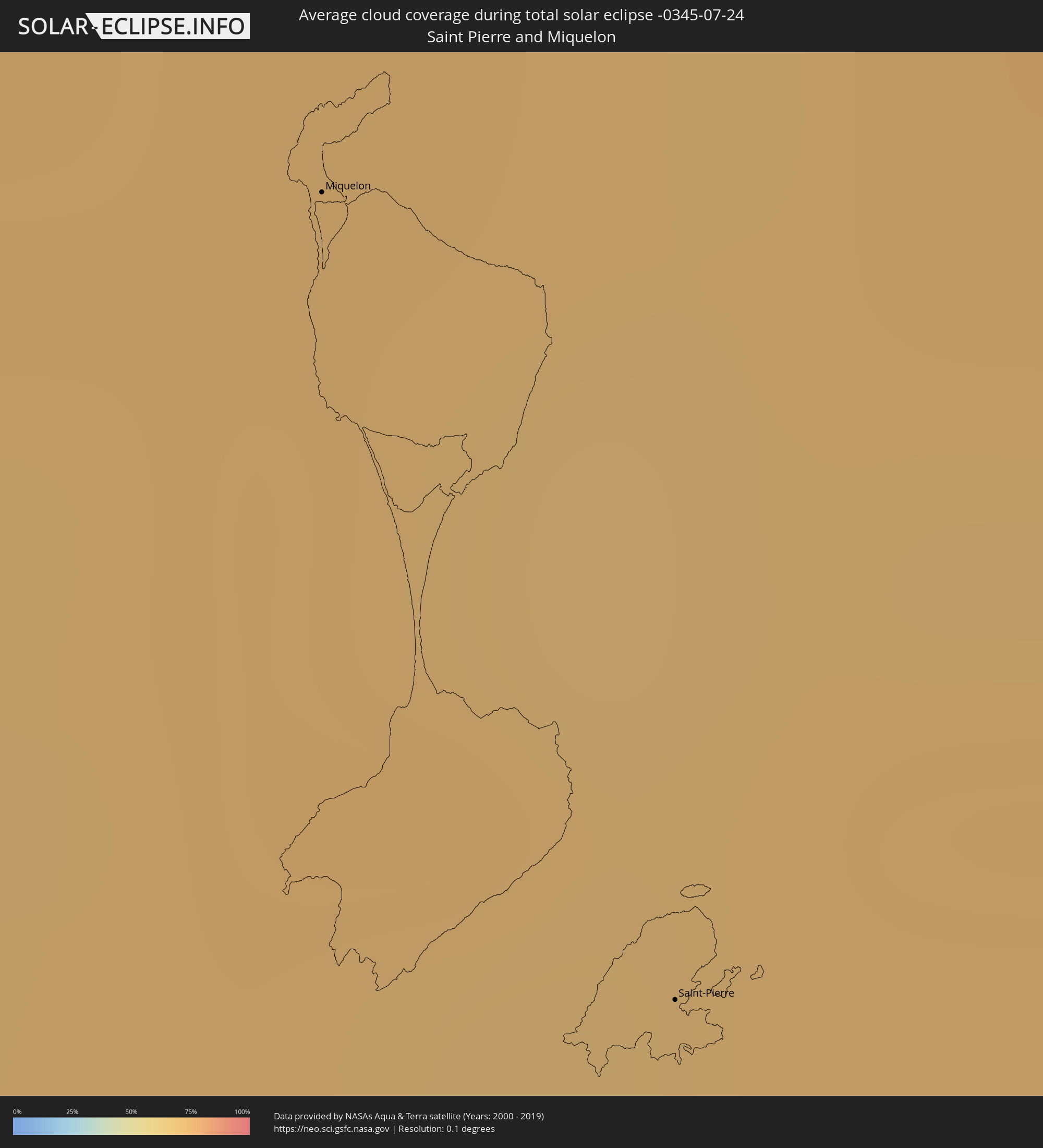 Saint-Pierre und Miquelon
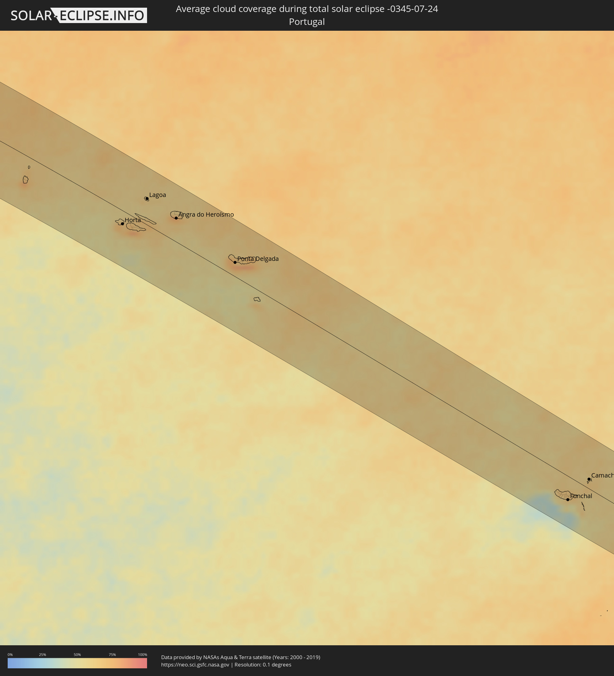 Portugal
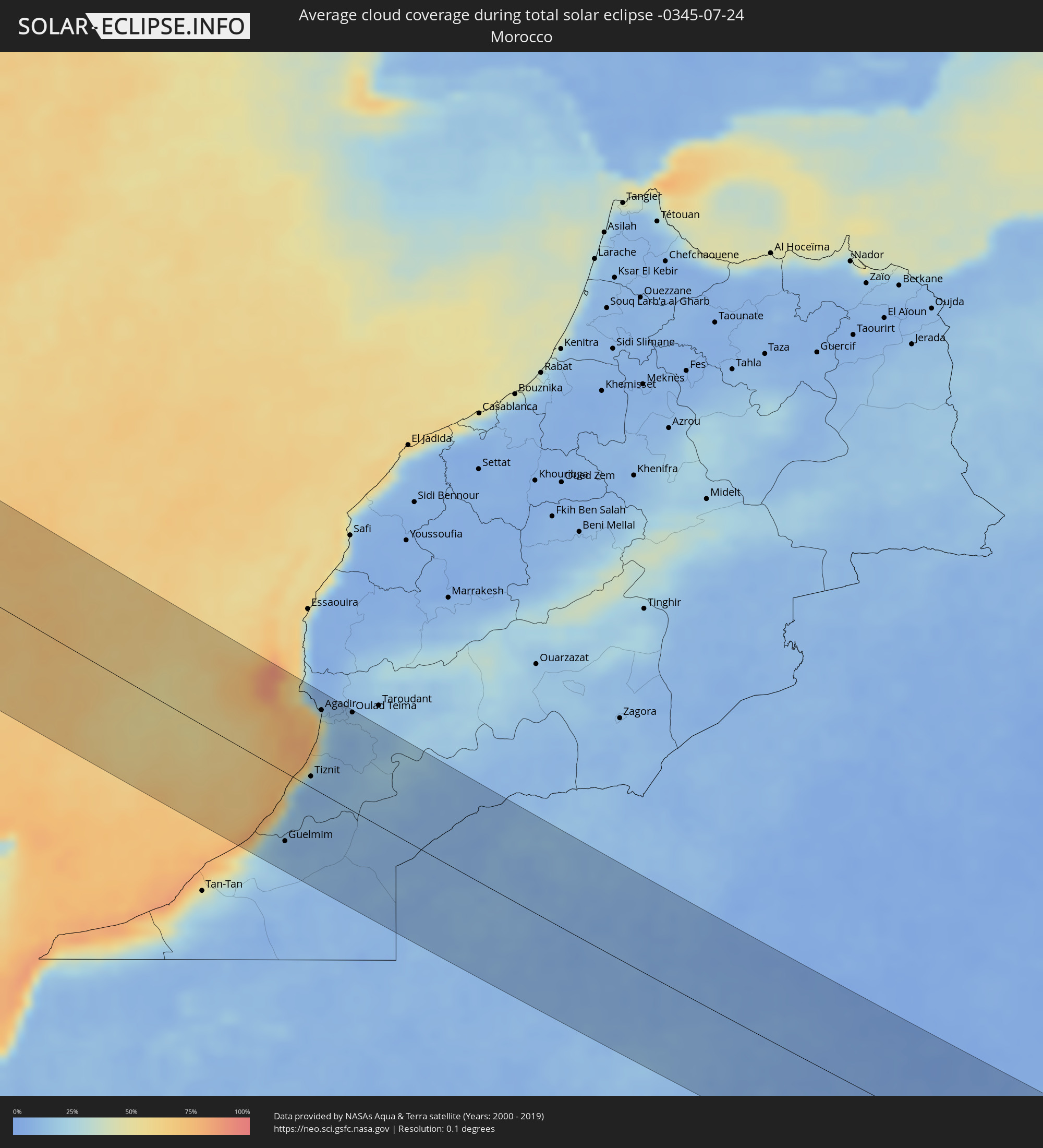 Marokko
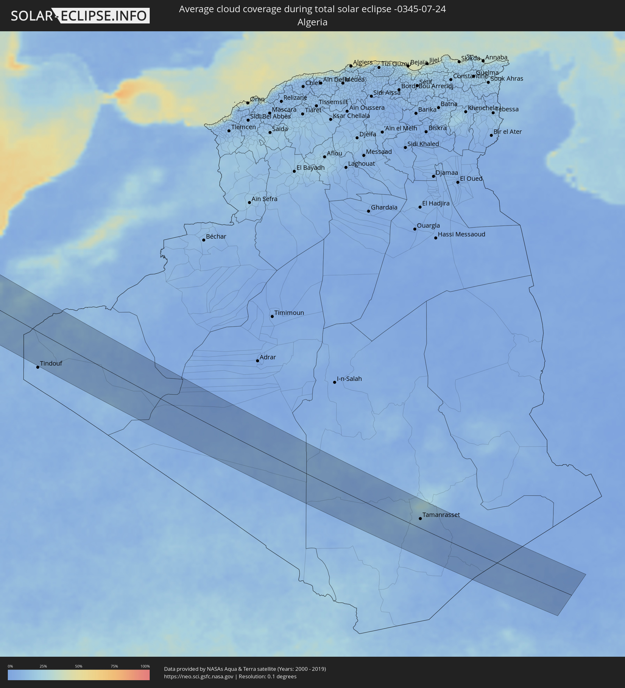 Algerien
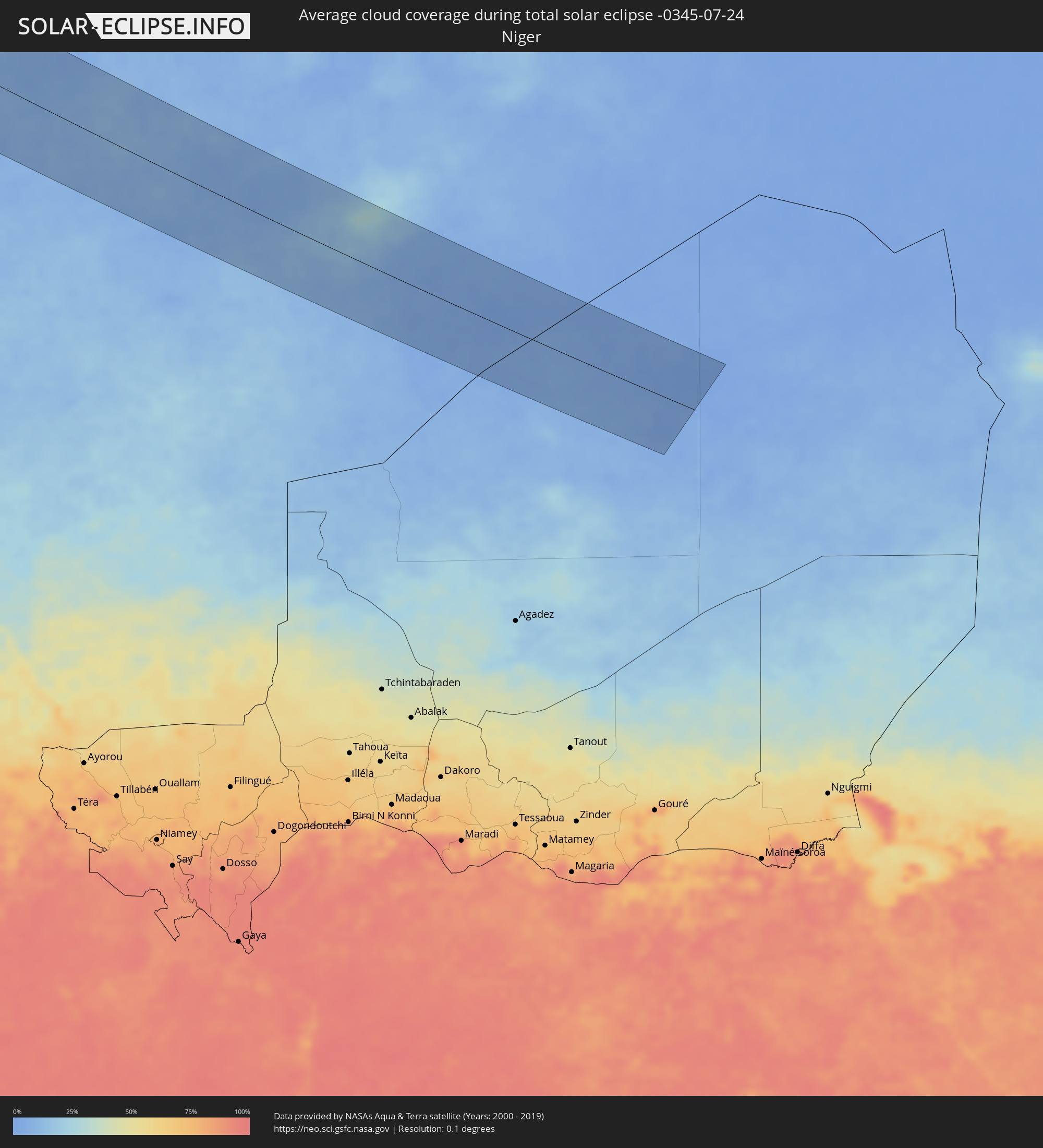 Niger
Niger
Orte im Finsternispfad
Die nachfolgene Tabelle zeigt Städte und Orte mit mehr als 5.000 Einwohnern, die sich im Finsternispfad befinden. Städte mit mehr als 100.000 Einwohnern sind dick gekennzeichnet. Mit einem Klick auf den Ort öffnet sich eine Detailkarte die die Lage des jeweiligen Ortes zusammen mit dem Verlauf der zentralen Finsternis präsentiert.
| Ort | Typ | Dauer der Verfinsterung | Ortszeit bei maximaler Verfinsterung | Entfernung zur Zentrallinie | Ø Bewölkung |
|
Santa Rosa, California
|
total | - | 06:54:21 UTC-08:00 | 39 km | 10% |
|
Petaluma, California
|
total | - | 06:54:06 UTC-08:00 | 15 km | 10% |
|
San Rafael, California
|
total | - | 06:53:49 UTC-08:00 | 15 km | 15% |
|
San Francisco, California
|
total | - | 06:53:36 UTC-08:00 | 39 km | 37% |
|
San Mateo, California
|
total | - | 06:53:21 UTC-08:00 | 64 km | 11% |
|
Napa, California
|
total | - | 06:54:16 UTC-08:00 | 8 km | 8% |
|
Berkeley, California
|
total | - | 06:53:45 UTC-08:00 | 35 km | 23% |
|
Vallejo, California
|
total | - | 06:54:02 UTC-08:00 | 13 km | 13% |
|
Mountain View, California
|
total | - | 06:53:12 UTC-08:00 | 91 km | 6% |
|
Hayward, California
|
total | - | 06:53:33 UTC-08:00 | 63 km | 13% |
|
Fairfield, California
|
total | - | 06:54:17 UTC-08:00 | 6 km | 8% |
|
Concord, California
|
total | - | 06:53:57 UTC-08:00 | 34 km | 6% |
|
Fremont, California
|
total | - | 06:53:25 UTC-08:00 | 79 km | 20% |
|
San Ramon, California
|
total | - | 06:53:43 UTC-08:00 | 56 km | 6% |
|
San Jose, California
|
total | - | 06:53:12 UTC-08:00 | 103 km | 4% |
|
Antioch, California
|
total | - | 06:54:02 UTC-08:00 | 40 km | 6% |
|
Woodland, California
|
total | - | 06:54:53 UTC-08:00 | 26 km | 7% |
|
Livermore, California
|
total | - | 06:53:39 UTC-08:00 | 74 km | 6% |
|
Davis, California
|
total | - | 06:54:44 UTC-08:00 | 12 km | 6% |
|
Yuba City, California
|
total | - | 06:55:31 UTC-08:00 | 66 km | 7% |
|
Sacramento, California
|
total | - | 06:54:51 UTC-08:00 | 6 km | 7% |
|
Tracy, California
|
total | - | 06:53:49 UTC-08:00 | 81 km | 8% |
|
Elk Grove, California
|
total | - | 06:54:40 UTC-08:00 | 16 km | 7% |
|
Rancho Cordova, California
|
total | - | 06:54:55 UTC-08:00 | 1 km | 7% |
|
Stockton, California
|
total | - | 06:54:08 UTC-08:00 | 64 km | 8% |
|
Roseville, California
|
total | - | 06:55:07 UTC-08:00 | 15 km | 7% |
|
Lodi, California
|
total | - | 06:54:21 UTC-08:00 | 48 km | 8% |
|
Manteca, California
|
total | - | 06:53:57 UTC-08:00 | 83 km | 8% |
|
Reno, Nevada
|
total | - | 06:56:35 UTC-08:00 | 37 km | 21% |
|
Ogden, Utah
|
total | - | 08:02:30 UTC-07:00 | 74 km | 18% |
|
Layton, Utah
|
total | - | 08:02:17 UTC-07:00 | 91 km | 18% |
|
Rapid City, South Dakota
|
total | - | 08:12:54 UTC-07:00 | 56 km | 31% |
|
Fargo, North Dakota
|
total | - | 09:22:52 UTC-06:00 | 72 km | 56% |
|
Duluth, Minnesota
|
total | - | 09:28:14 UTC-06:00 | 38 km | 51% |
|
Thunder Bay, Ontario
|
total | - | 10:33:33 UTC-05:00 | 84 km | 55% |
|
Kapuskasing, Ontario
|
total | - | 10:43:48 UTC-05:00 | 108 km | 66% |
|
Timmins, Ontario
|
total | - | 10:44:44 UTC-05:00 | 8 km | 65% |
|
Kirkland Lake, Ontario
|
total | - | 10:46:30 UTC-05:00 | 54 km | 65% |
|
La Sarre, Quebec
|
total | - | 10:48:12 UTC-05:00 | 13 km | 66% |
|
Rouyn-Noranda, Quebec
|
total | - | 10:48:09 UTC-05:00 | 51 km | 61% |
|
Amos, Quebec
|
total | - | 10:49:45 UTC-05:00 | 20 km | 69% |
|
Val-d'Or, Quebec
|
total | - | 10:50:01 UTC-05:00 | 74 km | 67% |
|
Saint-Félicien, Quebec
|
total | - | 10:58:58 UTC-05:00 | 26 km | 67% |
|
Roberval, Quebec
|
total | - | 10:59:18 UTC-05:00 | 41 km | 65% |
|
Dolbeau-Mistassini, Quebec
|
total | - | 10:59:23 UTC-05:00 | 0 km | 66% |
|
Pont Rouge, Quebec
|
total | - | 10:59:38 UTC-05:00 | 0 km | 65% |
|
Alma, Quebec
|
total | - | 11:00:17 UTC-05:00 | 37 km | 62% |
|
Jonquière, Quebec
|
total | - | 11:00:56 UTC-05:00 | 51 km | 68% |
|
Saguenay, Quebec
|
total | - | 11:01:14 UTC-05:00 | 51 km | 68% |
|
Rivière-du-Loup, Quebec
|
total | - | 11:03:46 UTC-05:00 | 112 km | 60% |
|
Rimouski, Quebec
|
total | - | 11:05:33 UTC-05:00 | 39 km | 58% |
|
Mont-Joli, Quebec
|
total | - | 11:06:07 UTC-05:00 | 22 km | 58% |
|
Baie-Comeau, Quebec
|
total | - | 11:06:11 UTC-05:00 | 48 km | 66% |
|
Matane, Quebec
|
total | - | 11:07:15 UTC-05:00 | 9 km | 61% |
|
Amqui, Quebec
|
total | - | 11:07:25 UTC-05:00 | 31 km | 67% |
|
Campbellton, New Brunswick
|
total | - | 11:54:21 UTC-04:14 | 77 km | 65% |
|
Sainte-Anne-des-Monts, Quebec
|
total | - | 11:08:57 UTC-05:00 | 48 km | 63% |
|
Bathurst, New Brunswick
|
total | - | 11:56:11 UTC-04:14 | 113 km | 64% |
|
Chandler, Quebec
|
total | - | 11:12:08 UTC-05:00 | 24 km | 64% |
|
Gaspé, Quebec
|
total | - | 11:12:22 UTC-05:00 | 31 km | 65% |
|
Stephenville, Newfoundland and Labrador
|
total | - | 12:51:31 UTC-03:30 | 72 km | 72% |
|
Miquelon, Miquelon-Langlade
|
total | - | 12:42:19 UTC-03:44 | 49 km | 71% |
|
Saint-Pierre, Saint-Pierre
|
total | - | 12:42:53 UTC-03:44 | 80 km | 71% |
|
Bay Roberts, Newfoundland and Labrador
|
total | - | 13:00:55 UTC-03:30 | 66 km | 67% |
|
Carbonear, Newfoundland and Labrador
|
total | - | 13:00:53 UTC-03:30 | 81 km | 69% |
|
Conception Bay South, Newfoundland and Labrador
|
total | - | 13:01:26 UTC-03:30 | 61 km | 66% |
|
Mount Pearl, Newfoundland and Labrador
|
total | - | 13:01:46 UTC-03:30 | 67 km | 66% |
|
St. John's, Newfoundland and Labrador
|
total | - | 13:01:51 UTC-03:30 | 74 km | 66% |
|
Ribeira Grande, Azores
|
total | - | 17:17:31 UTC+00:00 | 31 km | 63% |
|
Horta, Azores
|
total | - | 15:23:01 UTC-01:54 | 27 km | 67% |
|
Madalena, Azores
|
total | - | 15:23:07 UTC-01:54 | 22 km | 73% |
|
Lagoa, Azores
|
total | - | 15:22:52 UTC-01:54 | 51 km | 62% |
|
Angra do Heroísmo, Azores
|
total | - | 15:24:12 UTC-01:54 | 47 km | 73% |
|
Praia da Vitória, Azores
|
total | - | 15:24:13 UTC-01:54 | 61 km | 70% |
|
Arrifes, Azores
|
total | - | 15:26:57 UTC-01:54 | 30 km | 77% |
|
Ponta Delgada, Azores
|
total | - | 15:27:02 UTC-01:54 | 28 km | 67% |
|
Rosto de Cão, Azores
|
total | - | 15:27:01 UTC-01:54 | 30 km | 77% |
|
Rabo de Peixe, Azores
|
total | - | 15:27:00 UTC-01:54 | 38 km | 79% |
|
Vila Franca do Campo, Azores
|
total | - | 15:27:16 UTC-01:54 | 37 km | 66% |
|
Ribeira Brava, Madeira
|
total | - | 17:35:18 UTC+00:00 | 57 km | 54% |
|
São Vicente, Madeira
|
total | - | 16:58:21 UTC-00:36 | 41 km | 58% |
|
Câmara de Lobos, Madeira
|
total | - | 17:35:22 UTC+00:00 | 53 km | 46% |
|
Nossa Senhora do Monte, Madeira
|
total | - | 16:58:37 UTC-00:36 | 47 km | 61% |
|
Funchal, Madeira
|
total | - | 17:35:25 UTC+00:00 | 50 km | 53% |
|
Santana, Madeira
|
total | - | 16:58:26 UTC-00:36 | 34 km | 64% |
|
Caniço, Madeira
|
total | - | 16:58:41 UTC-00:36 | 48 km | 53% |
|
Camacha, Madeira
|
total | - | 16:58:37 UTC-00:36 | 43 km | 60% |
|
Santa Cruz, Madeira
|
total | - | 16:58:38 UTC-00:36 | 41 km | 60% |
|
Machico, Madeira
|
total | - | 16:58:38 UTC-00:36 | 38 km | 60% |
|
Camacha, Madeira
|
total | - | 16:58:18 UTC-00:36 | 20 km | 65% |
|
Sidi Ifni, Souss-Massa-Drâa
|
total | - | 17:12:18 UTC-00:30 | 40 km | 56% |
|
Guelmim, Guelmim-Es Smara
|
total | - | 17:12:50 UTC-00:30 | 73 km | 11% |
|
Tiznit, Souss-Massa-Drâa
|
total | - | 17:12:00 UTC-00:30 | 11 km | 11% |
|
Agadir, Souss-Massa-Drâa
|
total | - | 17:11:05 UTC-00:30 | 88 km | 48% |
|
Dakhla, Dakhla-Oued Ed-Dahab
|
total | - | 17:11:06 UTC-00:30 | 89 km | 48% |
|
Oulad Teïma, Souss-Massa-Drâa
|
total | - | 17:11:13 UTC-00:30 | 104 km | 15% |
|
Tamanrasset, Tamanrasset
|
total | - | 18:00:00 UTC+00:09 | 31 km | 15% |