Totale Sonnenfinsternis vom 17.01.-0428
| Wochentag: | Sonntag |
| Maximale Dauer der Verfinsterung: | 04m35s |
| Maximale Breite des Finsternispfades: | 195 km |
| Saroszyklus: | 63 |
| Bedeckungsgrad: | 100% |
| Magnitude: | 1.0494 |
| Gamma: | 0.5466 |
Wo kann man die Sonnenfinsternis vom 17.01.-0428 sehen?
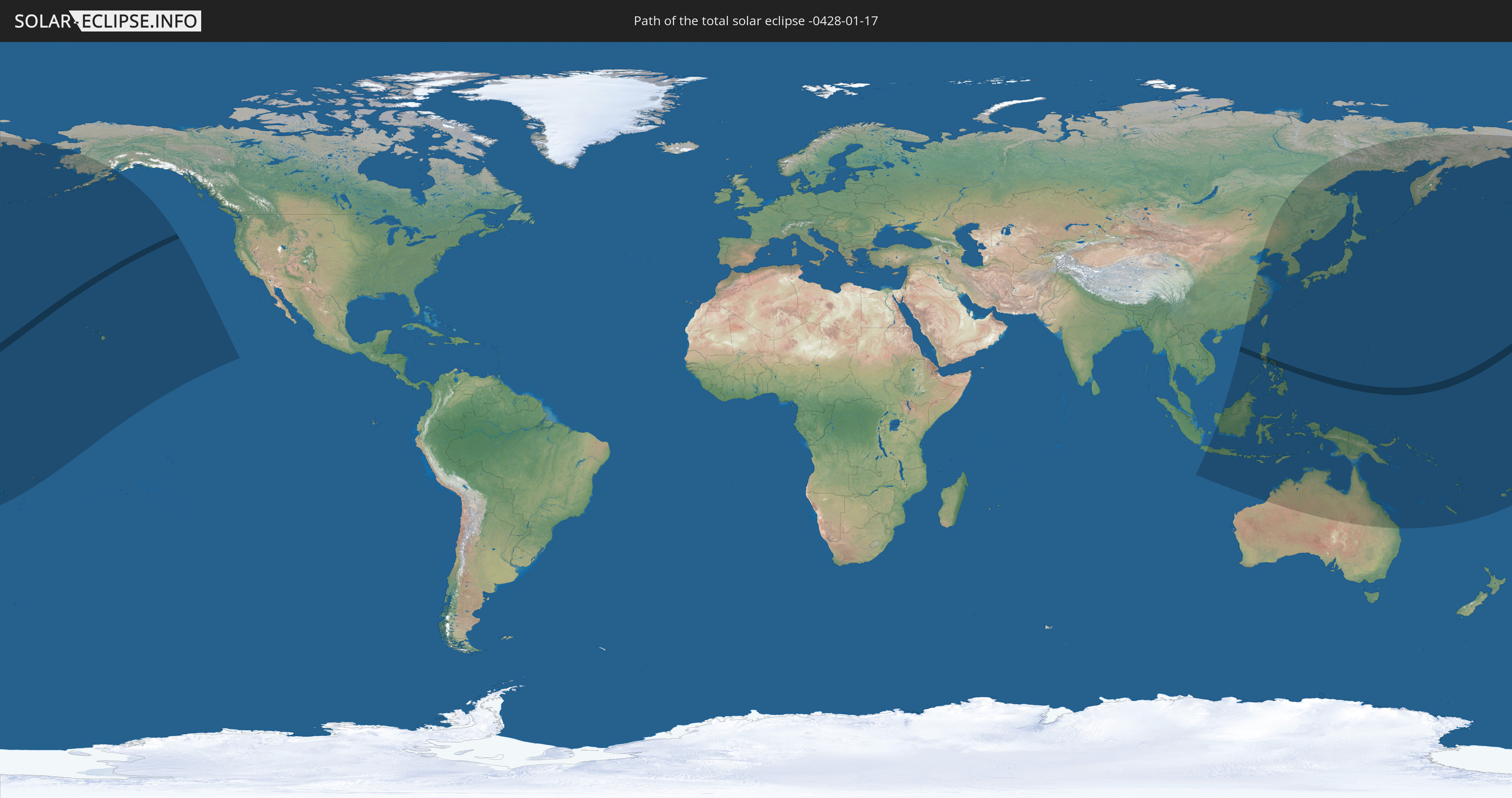
Die Sonnenfinsternis am 17.01.-0428 kann man in 33 Ländern als partielle Sonnenfinsternis beobachten.
Der Finsternispfad verläuft durch 3 Länder. Nur in diesen Ländern ist sie als totale Sonnenfinsternis zu sehen.
In den folgenden Ländern ist die Sonnenfinsternis total zu sehen
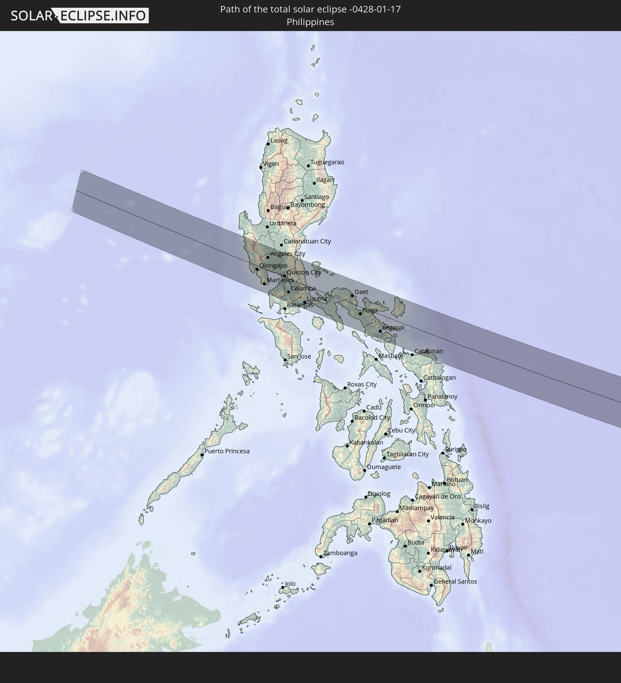 Philippinen
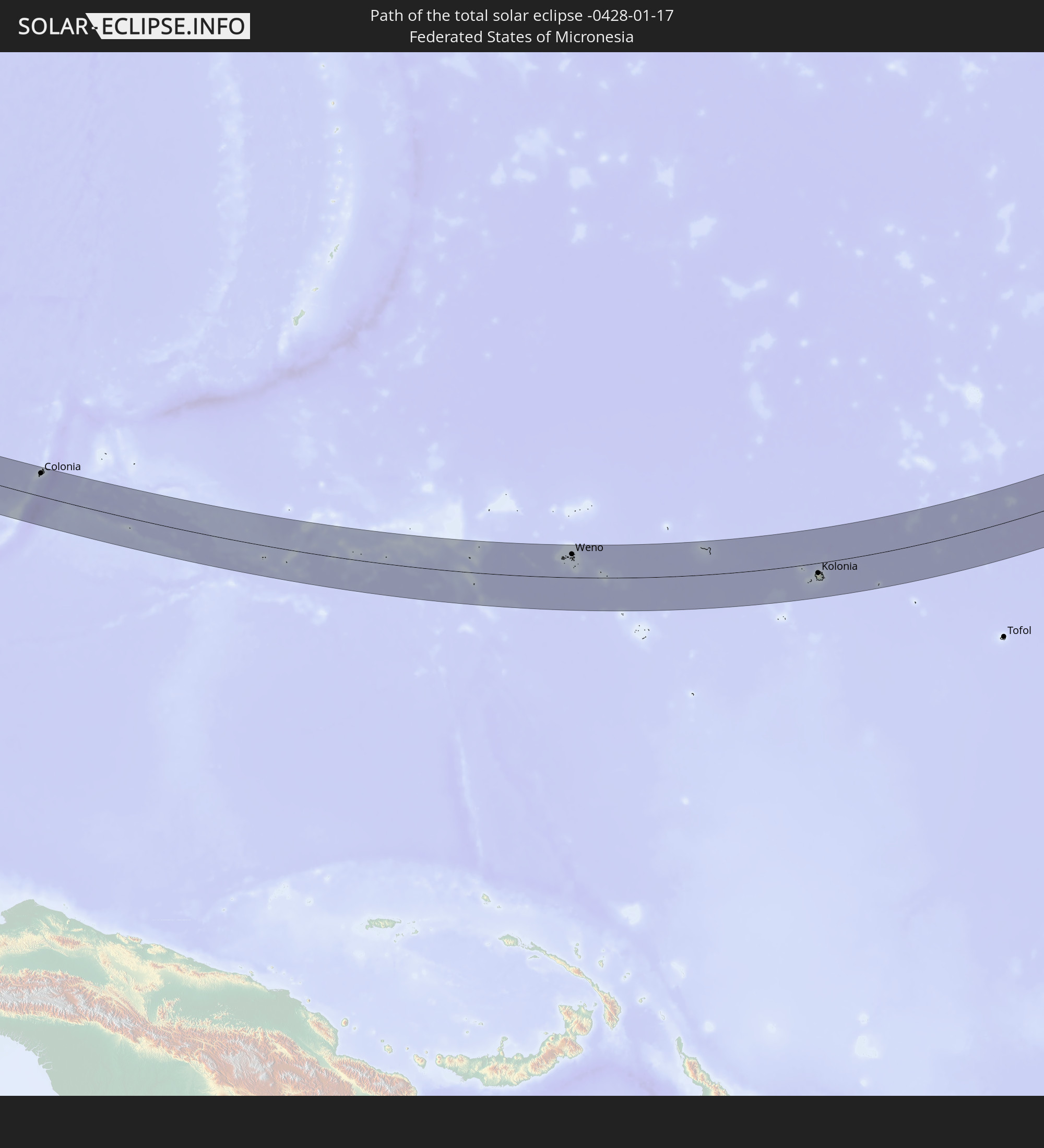 Föderierte Staaten von Mikronesien
 Marshallinseln
In den folgenden Ländern ist die Sonnenfinsternis partiell zu sehen
 Fidschi
 Russland
 Vereinigte Staaten
 United States Minor Outlying Islands
 Wallis und Futuna
 Tonga
Tonga
 Kiribati
 Samoa
Samoa
 Tokelau
 Amerikanisch-Samoa
 Cookinseln
 Volksrepublik China
 Indonesien
 Malaysia
 Australien
 Brunei
 Taiwan
 Philippinen
 Japan
Japan
 Osttimor
 Nordkorea
 Südkorea
 Palau
Palau
 Föderierte Staaten von Mikronesien
 Papua-Neuguinea
 Guam
Guam
 Nördliche Marianen
 Salomonen
 Neukaledonien
 Marshallinseln
 Vanuatu
 Nauru
Nauru
 Tuvalu
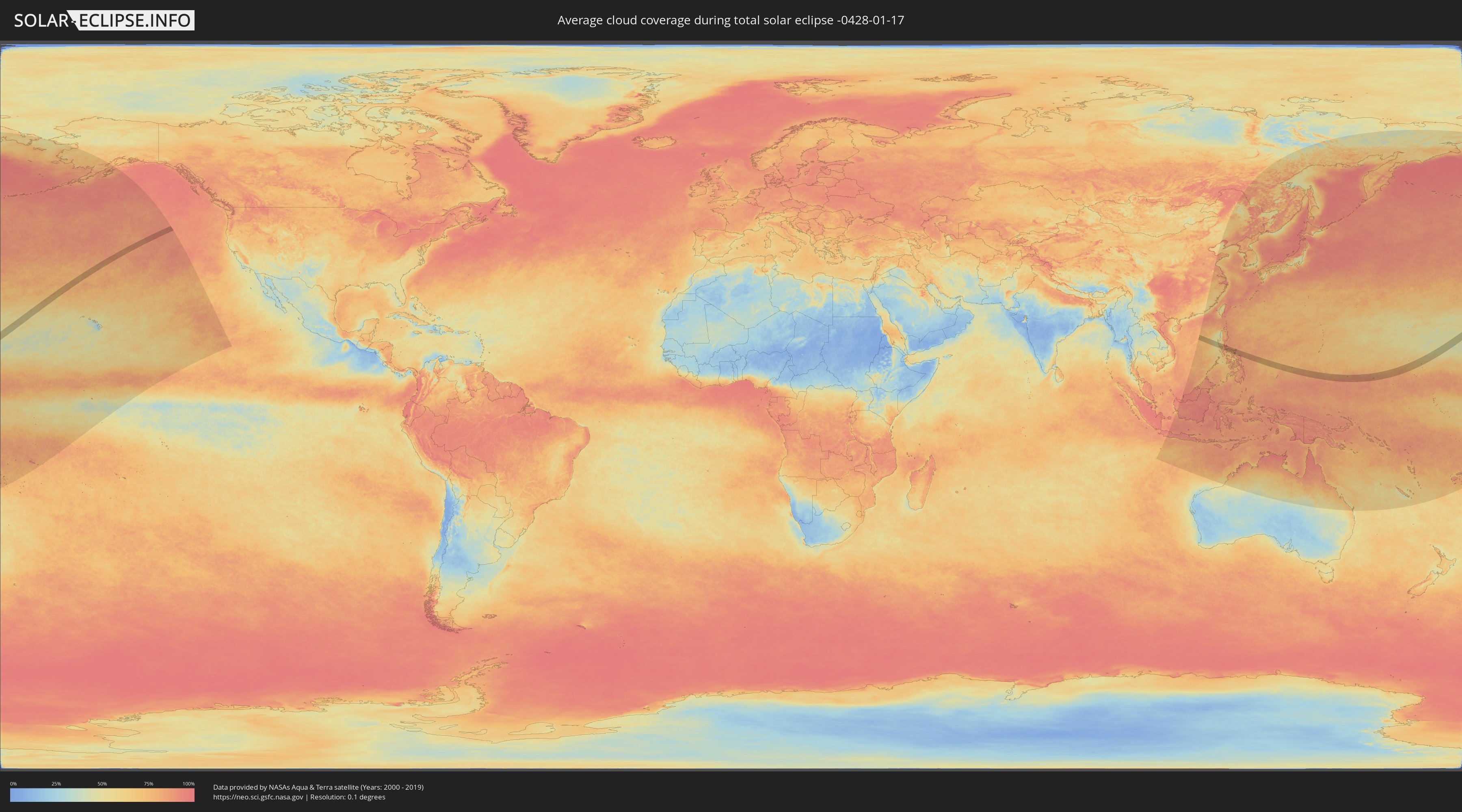
Wie wird das Wetter während der totalen Sonnenfinsternis am 17.01.-0428?
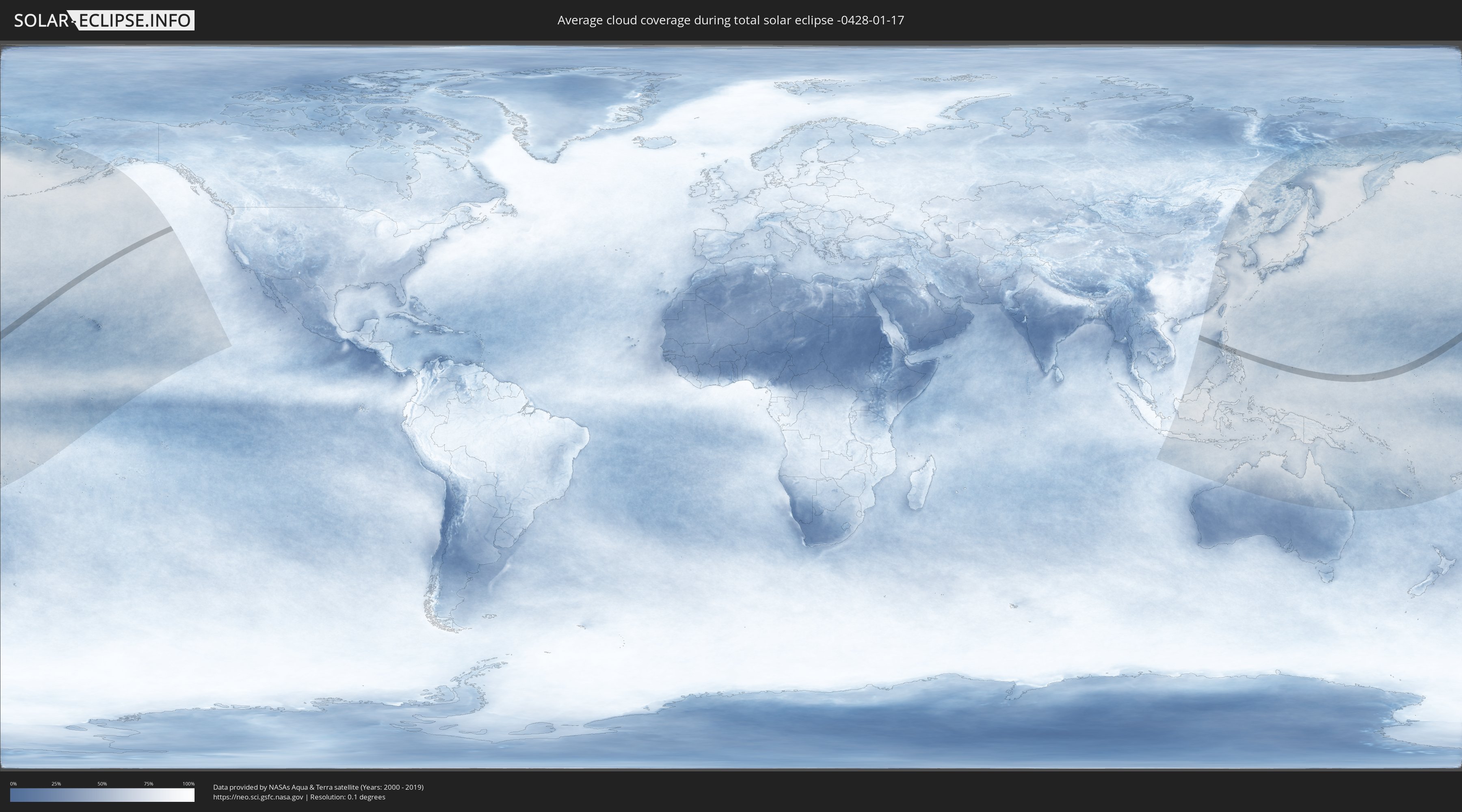
Wo ist der beste Ort, um die totale Sonnenfinsternis vom 17.01.-0428 zu beobachten?
Die folgenden Karten zeigen die durchschnittliche Bewölkung für den Tag, an dem die totale Sonnenfinsternis
stattfindet. Mit Hilfe der Karten lässt sich der Ort entlang des Finsternispfades eingrenzen,
der die besten Aussichen auf einen klaren wolkenfreien Himmel bietet.
Trotzdem muss man immer lokale Gegenenheiten beachten und sollte sich genau über das Wetter an seinem
gewählten Beobachtungsort informieren.
Die Daten stammen von den beiden NASA-Satelliten
AQUA und TERRA
und wurden über einen Zeitraum von 19 Jahren (2000 - 2019) gemittelt.
Detaillierte Länderkarten
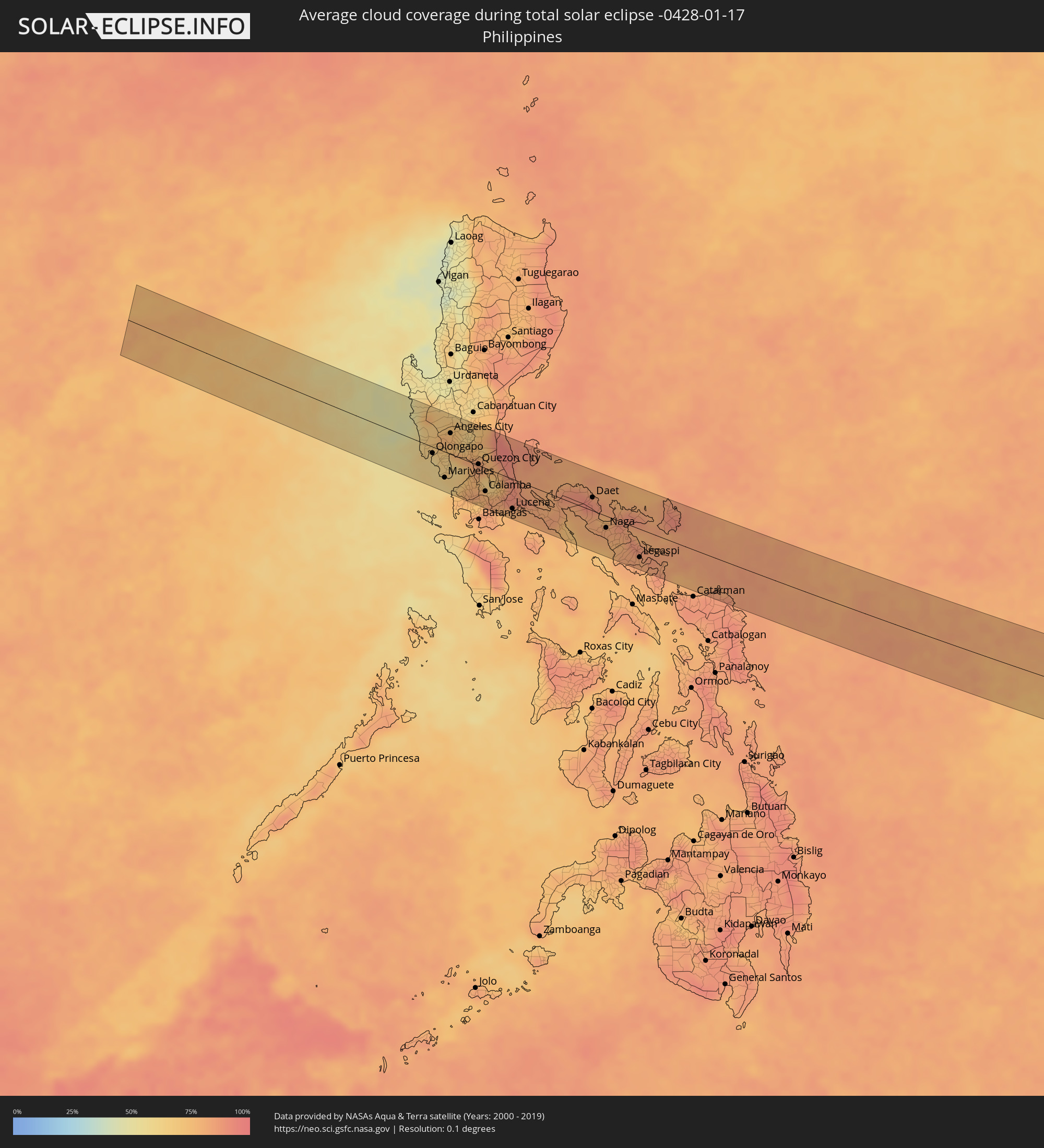 Philippinen
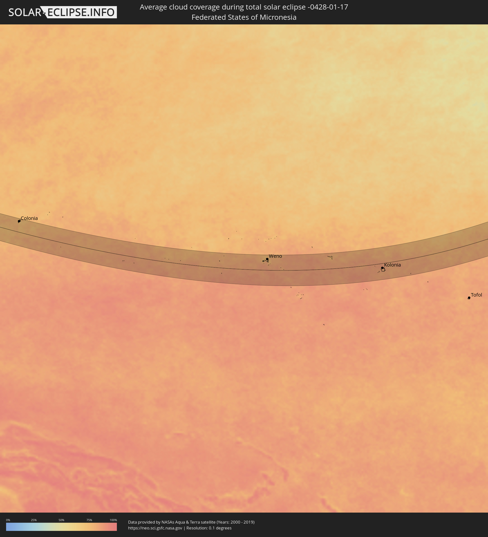 Föderierte Staaten von Mikronesien
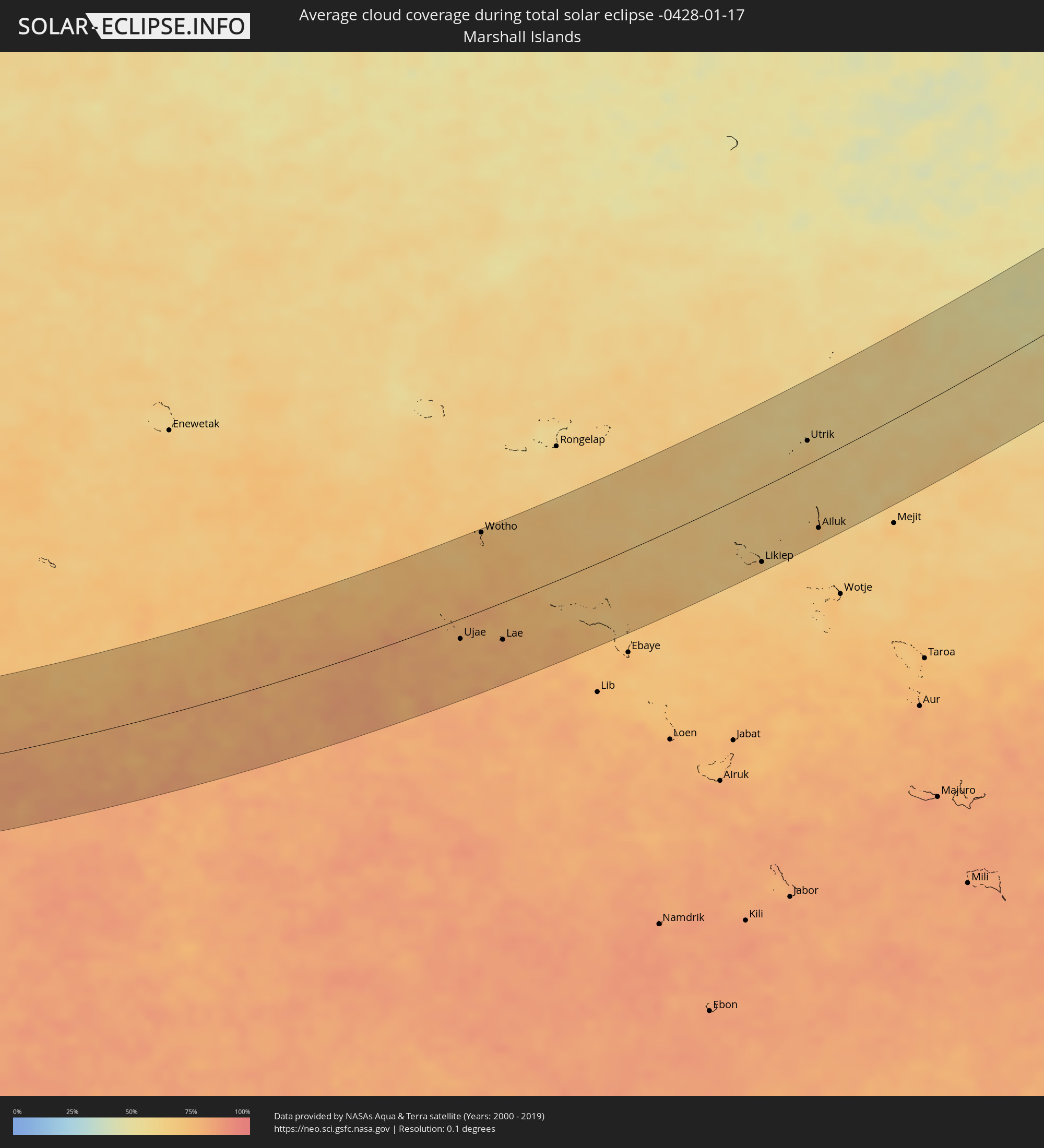 Marshallinseln
Orte im Finsternispfad
Die nachfolgene Tabelle zeigt Städte und Orte mit mehr als 5.000 Einwohnern, die sich im Finsternispfad befinden. Städte mit mehr als 100.000 Einwohnern sind dick gekennzeichnet. Mit einem Klick auf den Ort öffnet sich eine Detailkarte die die Lage des jeweiligen Ortes zusammen mit dem Verlauf der zentralen Finsternis präsentiert.
| Ort | Typ | Dauer der Verfinsterung | Ortszeit bei maximaler Verfinsterung | Entfernung zur Zentrallinie | Ø Bewölkung |
|
Masinloc, Central Luzon
|
total | - | 07:02:14 UTC+08:00 | 49 km | 57% |
|
Iba, Central Luzon
|
total | - | 07:02:06 UTC+08:00 | 29 km | 52% |
|
San Antonio, Central Luzon
|
total | - | 07:01:53 UTC+08:00 | 6 km | 64% |
|
Morong, Central Luzon
|
total | - | 07:01:47 UTC+08:00 | 27 km | 59% |
|
Olongapo, Central Luzon
|
total | - | 07:01:53 UTC+08:00 | 10 km | 58% |
|
Dinalupihan, Central Luzon
|
total | - | 07:02:01 UTC+08:00 | 2 km | 66% |
|
Mariveles, Central Luzon
|
total | - | 07:01:43 UTC+08:00 | 43 km | 61% |
|
Balanga, Central Luzon
|
total | - | 07:01:55 UTC+08:00 | 16 km | 64% |
|
Angeles City, Central Luzon
|
total | - | 07:02:16 UTC+08:00 | 35 km | 75% |
|
Capas, Central Luzon
|
total | - | 07:02:24 UTC+08:00 | 54 km | 72% |
|
San Fernando, Central Luzon
|
total | - | 07:02:14 UTC+08:00 | 27 km | 68% |
|
Naic, Calabarzon
|
total | - | 07:01:47 UTC+08:00 | 44 km | 77% |
|
Arayat, Central Luzon
|
total | - | 07:02:22 UTC+08:00 | 42 km | 63% |
|
General Emilio Aguinaldo, Calabarzon
|
total | - | 07:01:42 UTC+08:00 | 56 km | 78% |
|
Malolos, Central Luzon
|
total | - | 07:02:10 UTC+08:00 | 12 km | 81% |
|
Baliuag, Central Luzon
|
total | - | 07:02:18 UTC+08:00 | 27 km | 75% |
|
Cavite City, Calabarzon
|
total | - | 07:01:58 UTC+08:00 | 21 km | 76% |
|
Dasmariñas, Calabarzon
|
total | - | 07:01:53 UTC+08:00 | 36 km | 79% |
|
Gapan, Central Luzon
|
total | - | 07:02:34 UTC+08:00 | 66 km | 64% |
|
Patuto, Calabarzon
|
total | - | 07:01:45 UTC+08:00 | 56 km | 71% |
|
San Miguel, Central Luzon
|
total | - | 07:02:28 UTC+08:00 | 50 km | 75% |
|
San Jose del Monte, Central Luzon
|
total | - | 07:02:16 UTC+08:00 | 19 km | 83% |
|
Quezon City, Metro Manila
|
total | - | 07:02:10 UTC+08:00 | 2 km | 80% |
|
Lipa City, Calabarzon
|
total | - | 07:01:44 UTC+08:00 | 67 km | 84% |
|
Calamba, Calabarzon
|
total | - | 07:01:55 UTC+08:00 | 39 km | 79% |
|
Binangonan, Calabarzon
|
total | - | 07:02:06 UTC+08:00 | 11 km | 67% |
|
Rodriguez, Calabarzon
|
total | - | 07:02:19 UTC+08:00 | 19 km | 76% |
|
San Pablo, Calabarzon
|
total | - | 07:01:54 UTC+08:00 | 47 km | 81% |
|
Malaya, Calabarzon
|
total | - | 07:02:08 UTC+08:00 | 12 km | 66% |
|
Sampaloc, Calabarzon
|
total | - | 07:02:15 UTC+08:00 | 3 km | 78% |
|
Santa Cruz, Calabarzon
|
total | - | 07:02:06 UTC+08:00 | 21 km | 76% |
|
Candelaria, Calabarzon
|
total | - | 07:01:52 UTC+08:00 | 57 km | 76% |
|
Santa Maria, Calabarzon
|
total | - | 07:02:14 UTC+08:00 | 1 km | 78% |
|
Lucban, Calabarzon
|
total | - | 07:02:04 UTC+08:00 | 33 km | 89% |
|
Kalayaan, Calabarzon
|
total | - | 07:02:14 UTC+08:00 | 8 km | 90% |
|
Real, Calabarzon
|
total | - | 07:02:28 UTC+08:00 | 26 km | 89% |
|
Lucena, Calabarzon
|
total | - | 07:01:58 UTC+08:00 | 50 km | 79% |
|
Mauban, Calabarzon
|
total | - | 07:02:13 UTC+08:00 | 18 km | 87% |
|
Atimonan, Calabarzon
|
total | - | 07:02:11 UTC+08:00 | 30 km | 82% |
|
Gumaca, Calabarzon
|
total | - | 07:02:14 UTC+08:00 | 31 km | 80% |
|
General Luna, Calabarzon
|
total | - | 07:02:07 UTC+08:00 | 53 km | 81% |
|
Patnanungan, Calabarzon
|
total | - | 07:02:53 UTC+08:00 | 61 km | 83% |
|
Lopez, Calabarzon
|
total | - | 07:02:18 UTC+08:00 | 29 km | 83% |
|
Catanauan, Calabarzon
|
total | - | 07:02:08 UTC+08:00 | 57 km | 78% |
|
Santa Elena, Bicol
|
total | - | 07:02:34 UTC+08:00 | 6 km | 87% |
|
Tagkawayan Sabang, Calabarzon
|
total | - | 07:02:32 UTC+08:00 | 7 km | 80% |
|
San Narciso, Calabarzon
|
total | - | 07:02:16 UTC+08:00 | 49 km | 71% |
|
Jose Pañganiban, Bicol
|
total | - | 07:02:50 UTC+08:00 | 30 km | 87% |
|
Ragay, Bicol
|
total | - | 07:02:34 UTC+08:00 | 15 km | 78% |
|
Daet, Bicol
|
total | - | 07:02:52 UTC+08:00 | 22 km | 87% |
|
Sipocot, Bicol
|
total | - | 07:02:39 UTC+08:00 | 13 km | 80% |
|
Pasacao, Bicol
|
total | - | 07:02:31 UTC+08:00 | 37 km | 80% |
|
Naga, Bicol
|
total | - | 07:02:40 UTC+08:00 | 20 km | 82% |
|
Bula, Bicol
|
total | - | 07:02:38 UTC+08:00 | 32 km | 80% |
|
Tinambac, Bicol
|
total | - | 07:02:54 UTC+08:00 | 6 km | 83% |
|
Pantao, Bicol
|
total | - | 07:02:29 UTC+08:00 | 58 km | 78% |
|
Iriga City, Bicol
|
total | - | 07:02:41 UTC+08:00 | 30 km | 78% |
|
Polangui, Bicol
|
total | - | 07:02:39 UTC+08:00 | 42 km | 82% |
|
Goa, Bicol
|
total | - | 07:02:55 UTC+08:00 | 0 km | 83% |
|
Daraga, Bicol
|
total | - | 07:02:41 UTC+08:00 | 48 km | 81% |
|
Tabaco, Bicol
|
total | - | 07:02:51 UTC+08:00 | 25 km | 86% |
|
Legaspi, Bicol
|
total | - | 07:02:42 UTC+08:00 | 48 km | 81% |
|
Sorsogon, Bicol
|
total | - | 07:02:45 UTC+08:00 | 55 km | 83% |
|
Gubat, Bicol
|
total | - | 07:02:48 UTC+08:00 | 56 km | 85% |
|
Virac, Bicol
|
total | - | 07:03:20 UTC+08:00 | 18 km | 81% |
|
Laoang, Eastern Visayas
|
total | - | 07:03:11 UTC+08:00 | 58 km | 83% |
|
Gamay, Eastern Visayas
|
total | - | 07:03:16 UTC+08:00 | 66 km | 83% |
|
Colonia, Yap
|
total | - | 09:14:58 UTC+10:00 | 63 km | 74% |
|
Weno, Chuuk
|
total | - | 09:39:36 UTC+10:00 | 66 km | 81% |
|
Palikir - National Government Center, Pohnpei
|
total | - | 10:55:12 UTC+11:00 | 32 km | 82% |
|
Kolonia Town, Pohnpei
|
total | - | 10:55:22 UTC+11:00 | 29 km | 81% |
|
Kolonia, Pohnpei
|
total | - | 10:55:22 UTC+11:00 | 29 km | 81% |
|
Ujae, Ujae Atoll
|
total | - | 11:18:40 UTC+11:00 | 24 km | 77% |
|
Wotho, Wotho Atoll
|
total | - | 11:20:45 UTC+11:00 | 94 km | 75% |
|
Lae, Lae Atoll
|
total | - | 11:20:05 UTC+11:00 | 45 km | 77% |
|
Likiep, Likiep Atoll
|
total | - | 11:29:45 UTC+11:00 | 87 km | 67% |
|
Utrik, Utrik Atoll
|
total | - | 11:32:51 UTC+11:00 | 27 km | 64% |
|
Ailuk, Ailuk Atoll
|
total | - | 11:32:04 UTC+11:00 | 80 km | 67% |