Totale Sonnenfinsternis vom 06.08.-0699
| Wochentag: | Donnerstag |
| Maximale Dauer der Verfinsterung: | 02m38s |
| Maximale Breite des Finsternispfades: | 225 km |
| Saroszyklus: | 63 |
| Bedeckungsgrad: | 100% |
| Magnitude: | 1.041 |
| Gamma: | 0.789 |
Wo kann man die Sonnenfinsternis vom 06.08.-0699 sehen?
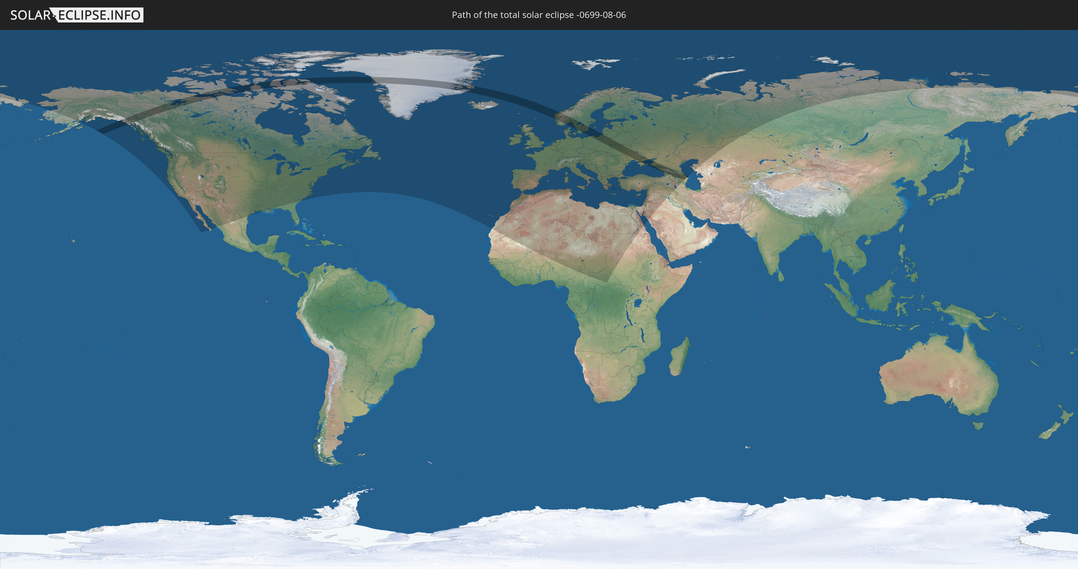
Die Sonnenfinsternis am 06.08.-0699 kann man in 83 Ländern als partielle Sonnenfinsternis beobachten.
Der Finsternispfad verläuft durch 13 Länder. Nur in diesen Ländern ist sie als totale Sonnenfinsternis zu sehen.
In den folgenden Ländern ist die Sonnenfinsternis total zu sehen
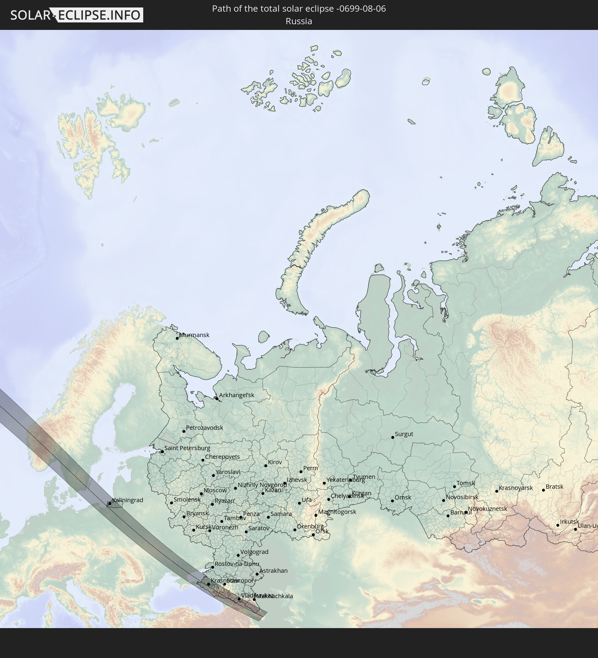 Russland
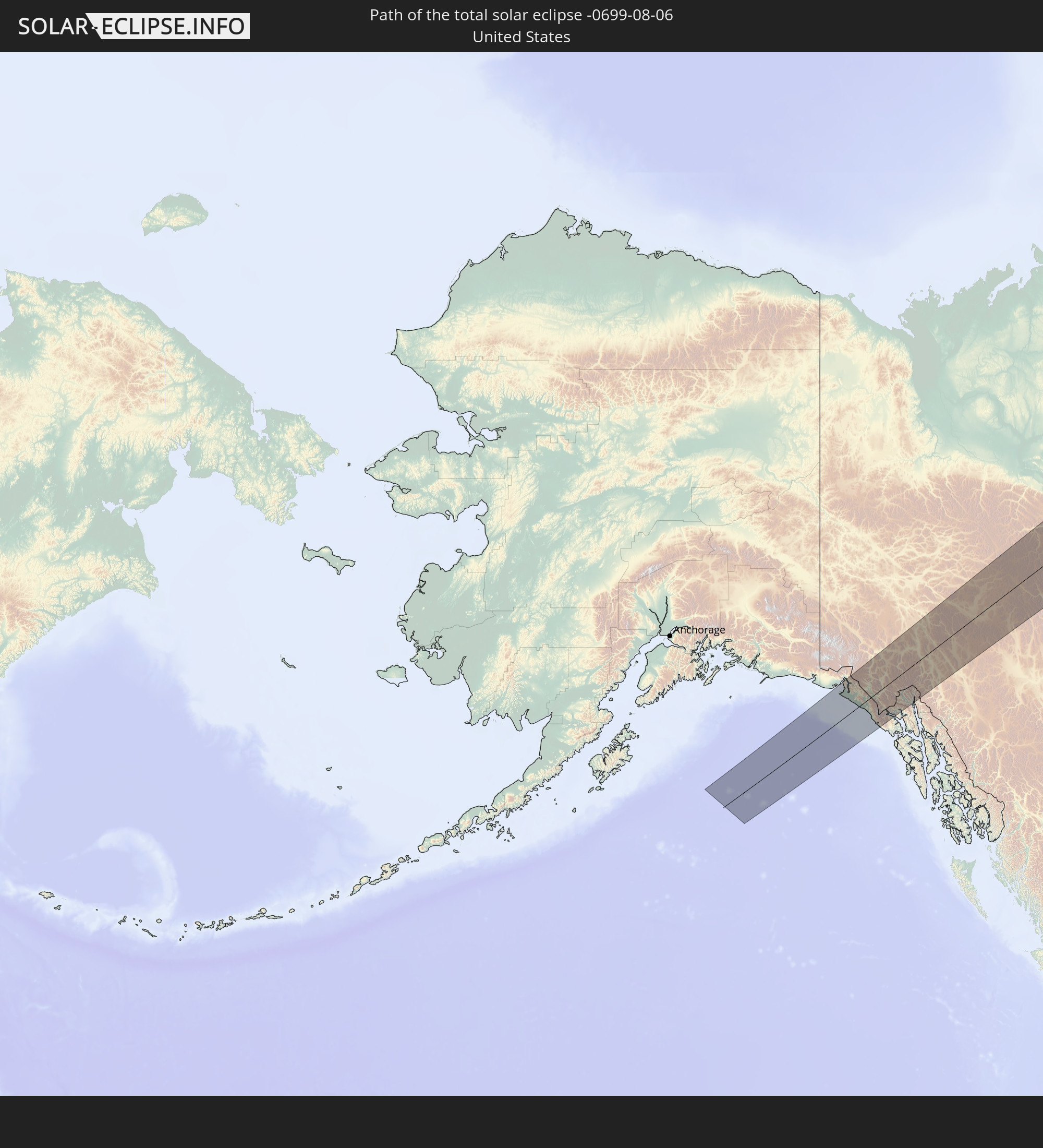 Vereinigte Staaten
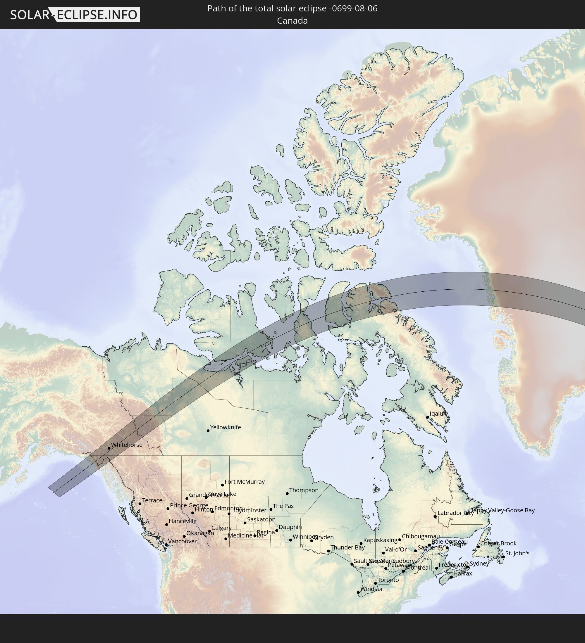 Kanada
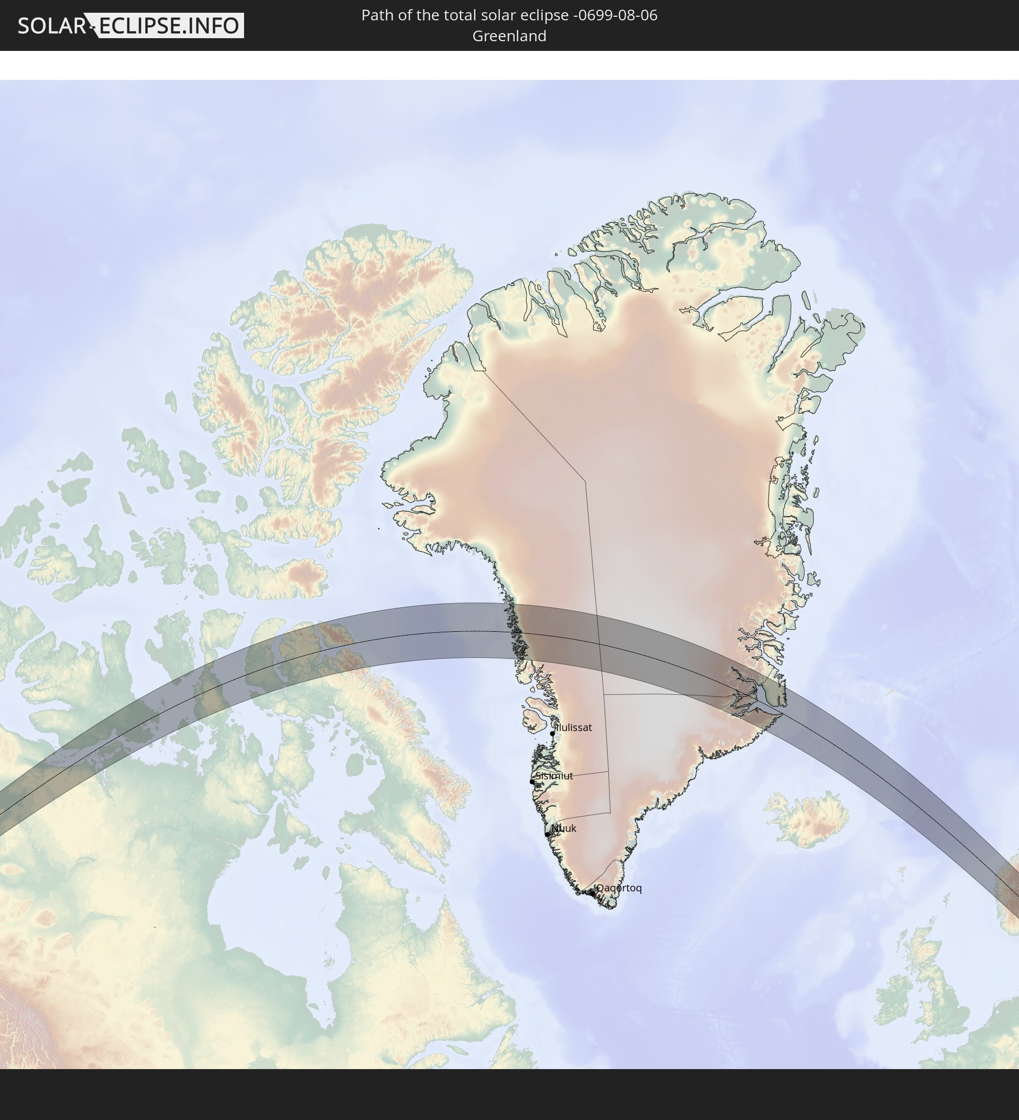 Grönland
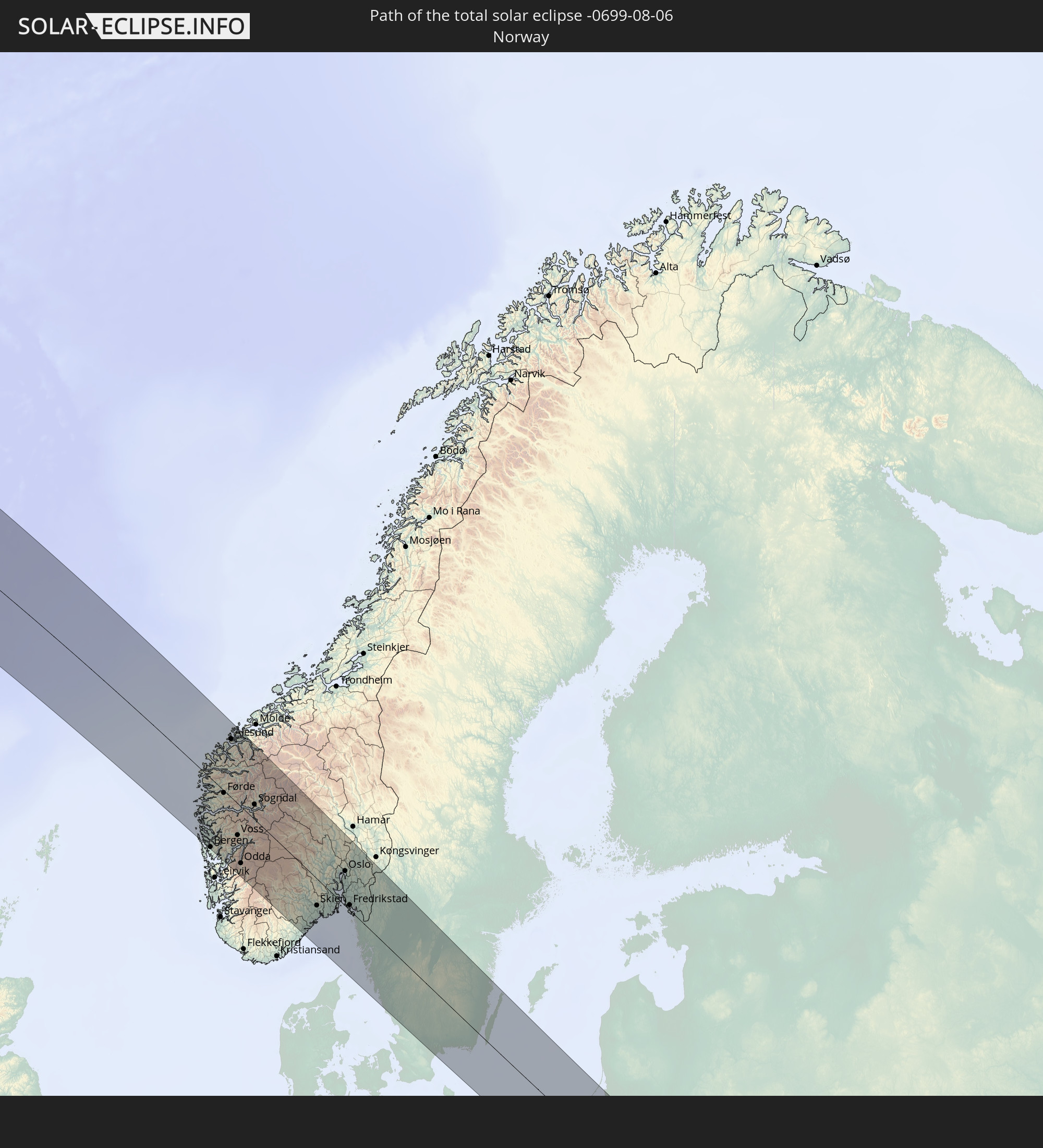 Norwegen
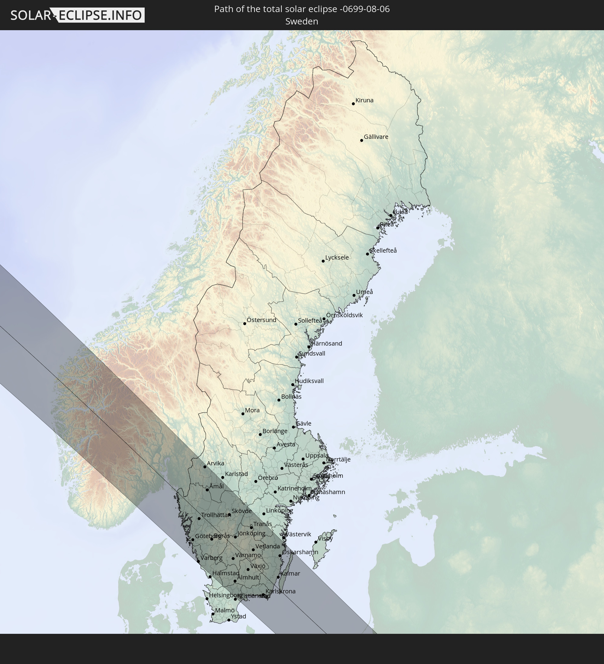 Schweden
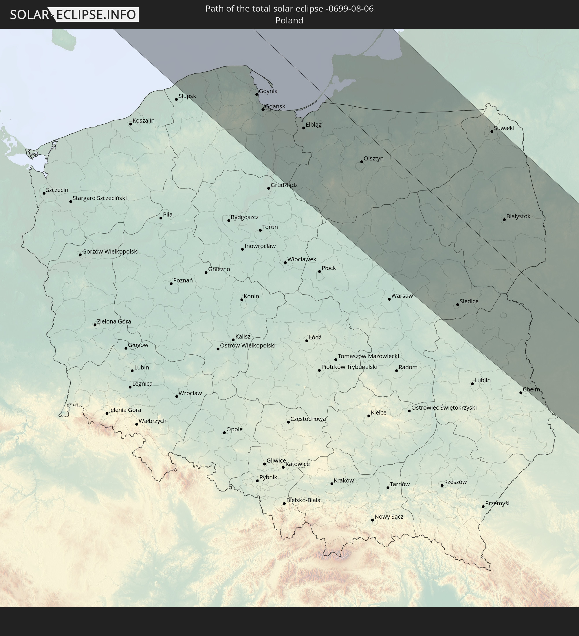 Polen
Polen
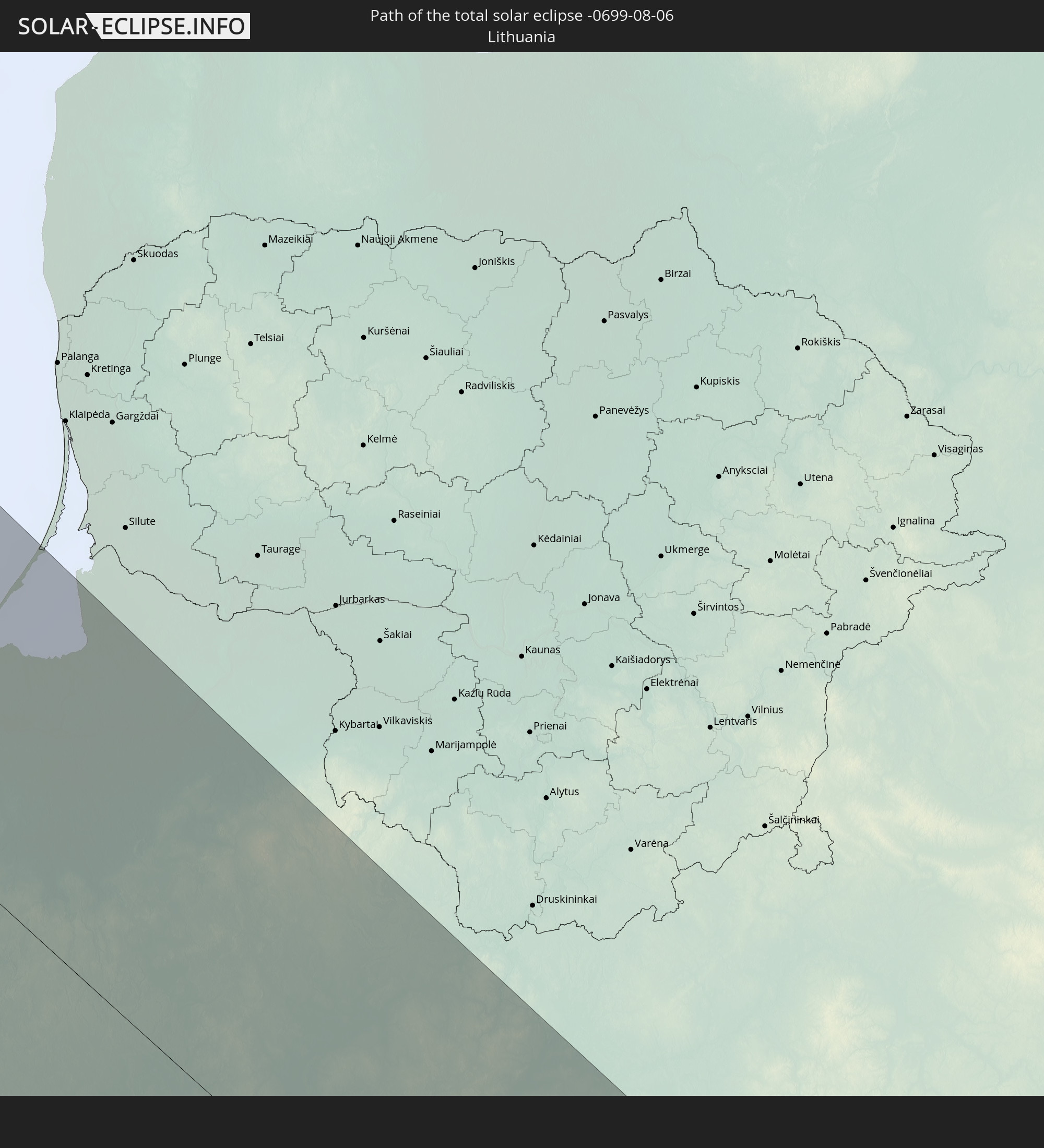 Litauen
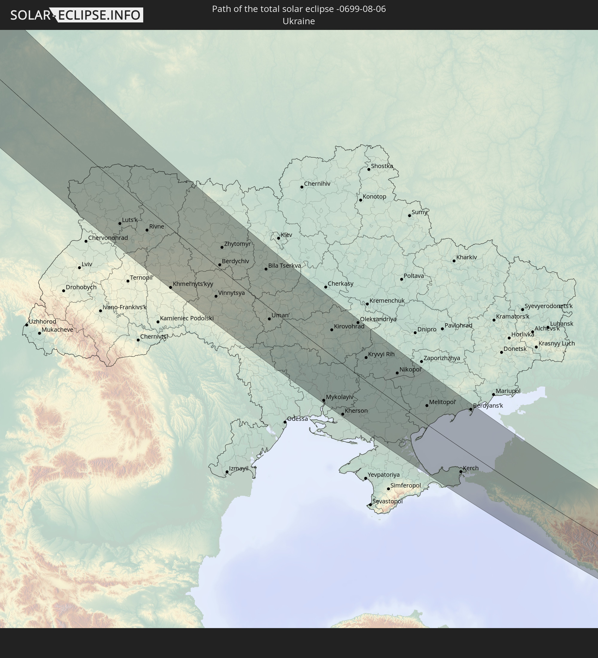 Ukraine
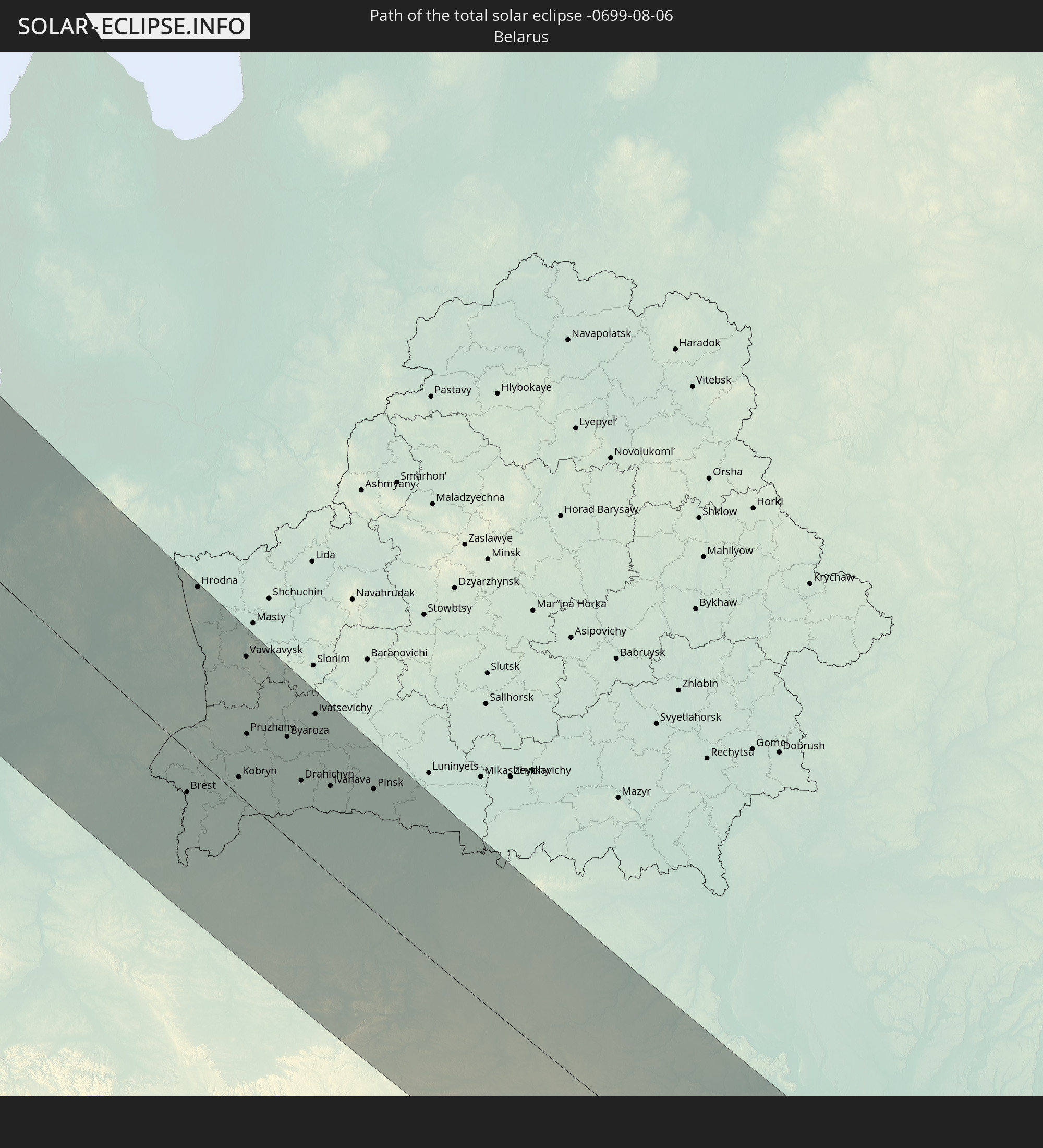 Weißrussland
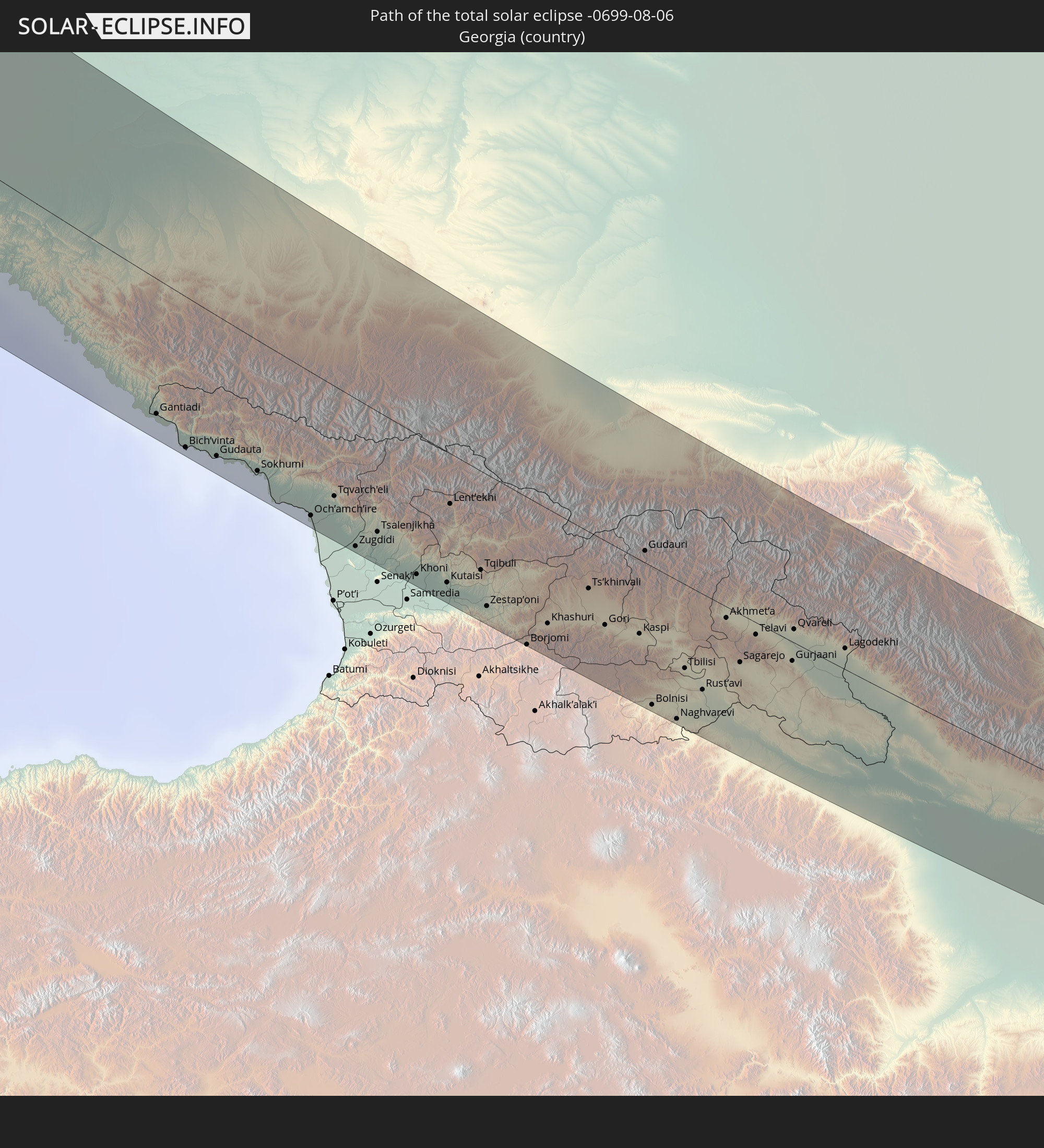 Georgien
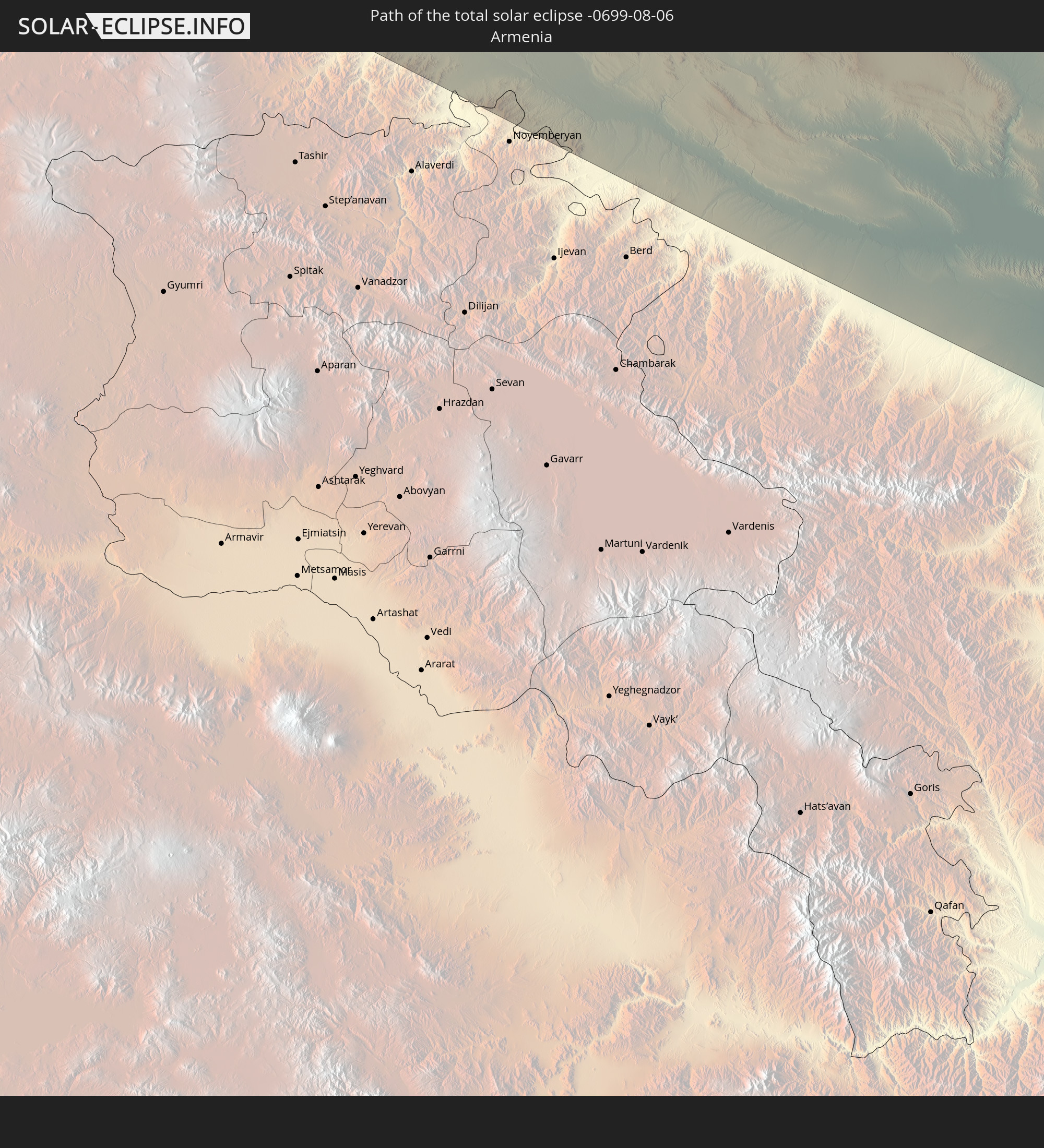 Armenien
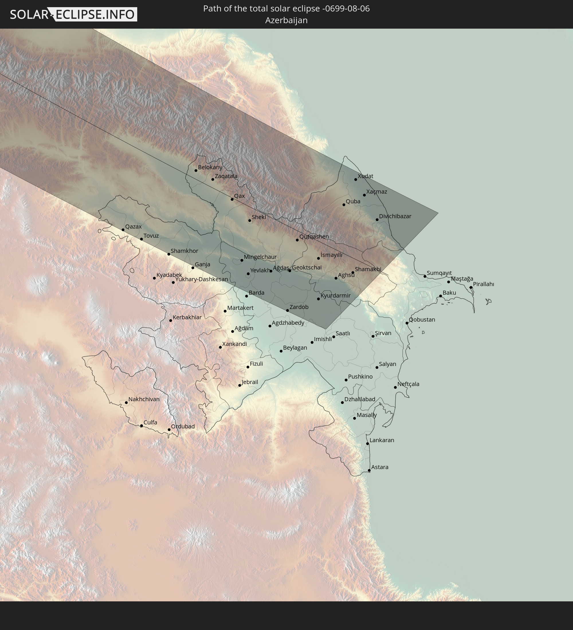 Aserbaidschan
In den folgenden Ländern ist die Sonnenfinsternis partiell zu sehen
 Russland
 Vereinigte Staaten
 Kanada
 Mexiko
 Grönland
 Saint-Pierre und Miquelon
 Portugal
 Island
 Spanien
 Mauretanien
 Marokko
 Mali
Mali
 Irland
 Spitzbergen
 Algerien
 Vereinigtes Königreich
 Färöer
 Gibraltar
 Frankreich
 Isle of Man
 Guernsey
 Jersey
 Niger
Niger
 Andorra
 Belgien
 Nigeria
 Niederlande
 Norwegen
 Luxemburg
 Deutschland
 Schweiz
 Italien
 Monaco
 Tunesien
 Dänemark
 Kamerun
 Libyen
 Liechtenstein
 Österreich
 Schweden
 Tschechien
 San Marino
 Vatikanstadt
 Slowenien
 Tschad
 Kroatien
 Polen
Polen
 Malta
Malta
 Zentralafrikanische Republik
 Bosnien und Herzegowina
 Ungarn
 Slowakei
 Montenegro
 Serbien
 Albanien
 Åland Islands
 Griechenland
 Rumänien
 Mazedonien
 Finnland
 Litauen
 Lettland
 Estland
 Sudan
Sudan
 Ukraine
 Bulgarien
 Weißrussland
 Ägypten
 Türkei
 Moldawien
 Republik Zypern
 Staat Palästina
 Israel
 Saudi-Arabien
 Jordanien
 Libanon
 Syrien
 Irak
Irak
 Georgien
 Armenien
 Iran
Iran
 Aserbaidschan
 Kasachstan
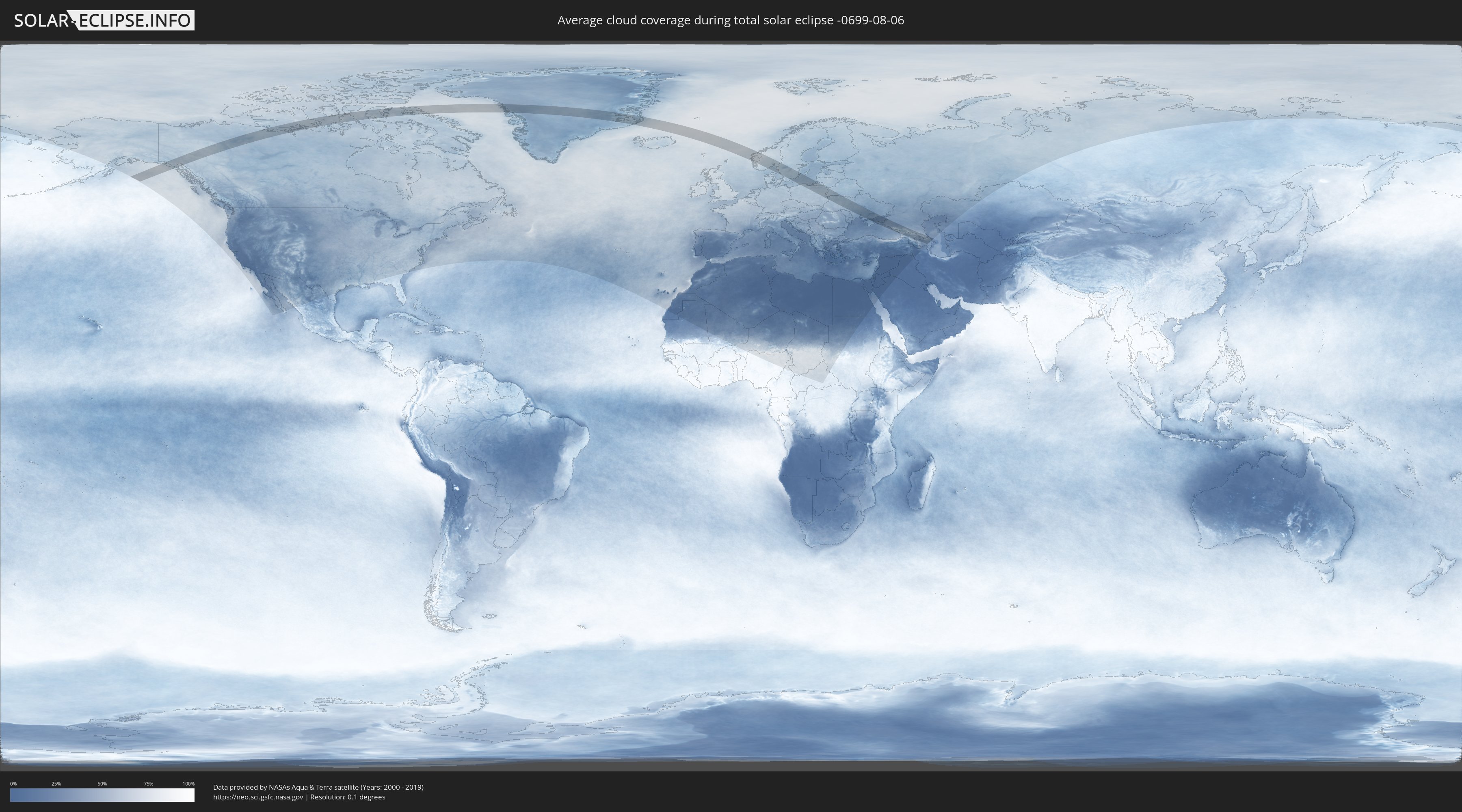
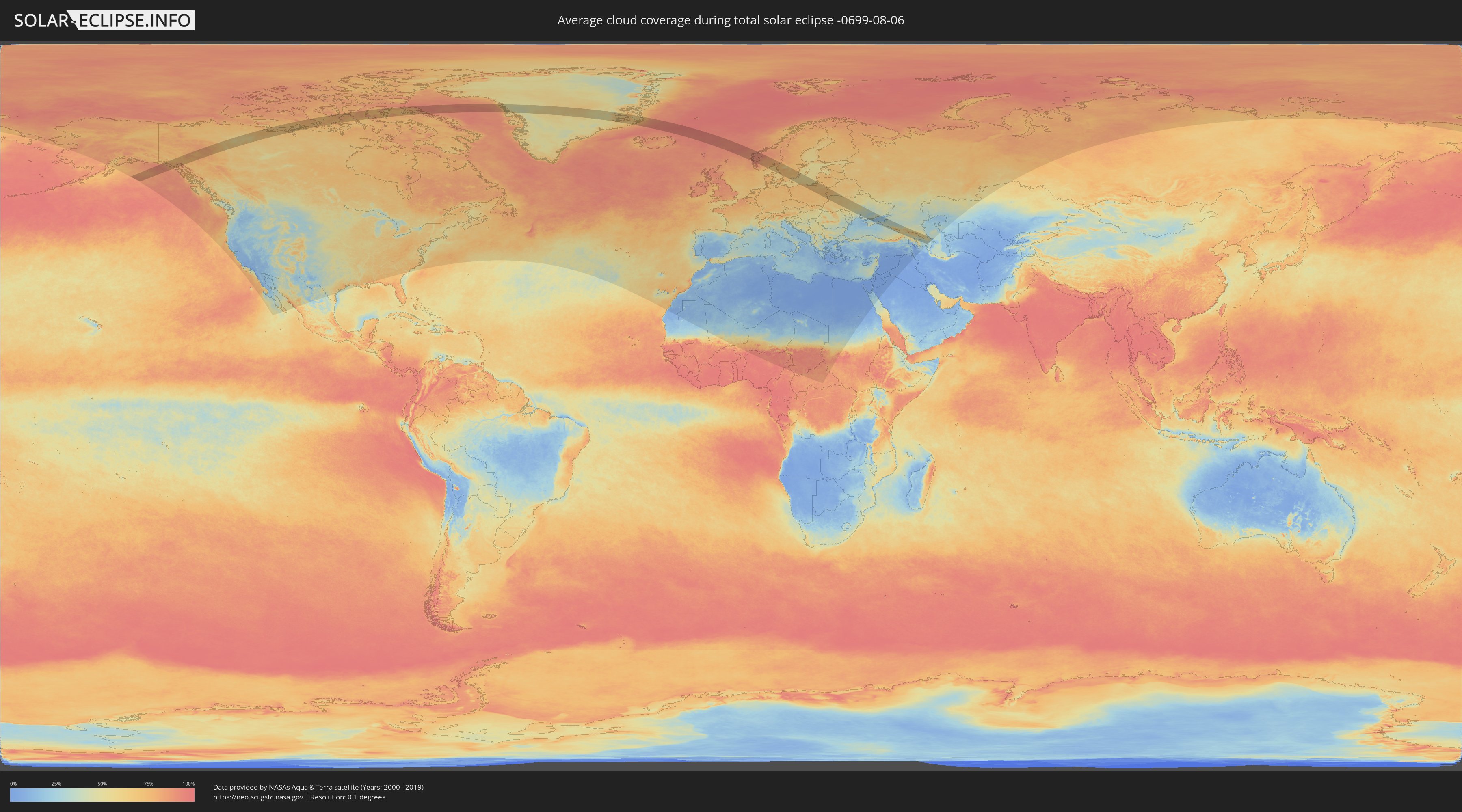
Wie wird das Wetter während der totalen Sonnenfinsternis am 06.08.-0699?
Wo ist der beste Ort, um die totale Sonnenfinsternis vom 06.08.-0699 zu beobachten?
Die folgenden Karten zeigen die durchschnittliche Bewölkung für den Tag, an dem die totale Sonnenfinsternis
stattfindet. Mit Hilfe der Karten lässt sich der Ort entlang des Finsternispfades eingrenzen,
der die besten Aussichen auf einen klaren wolkenfreien Himmel bietet.
Trotzdem muss man immer lokale Gegenenheiten beachten und sollte sich genau über das Wetter an seinem
gewählten Beobachtungsort informieren.
Die Daten stammen von den beiden NASA-Satelliten
AQUA und TERRA
und wurden über einen Zeitraum von 19 Jahren (2000 - 2019) gemittelt.
Detaillierte Länderkarten
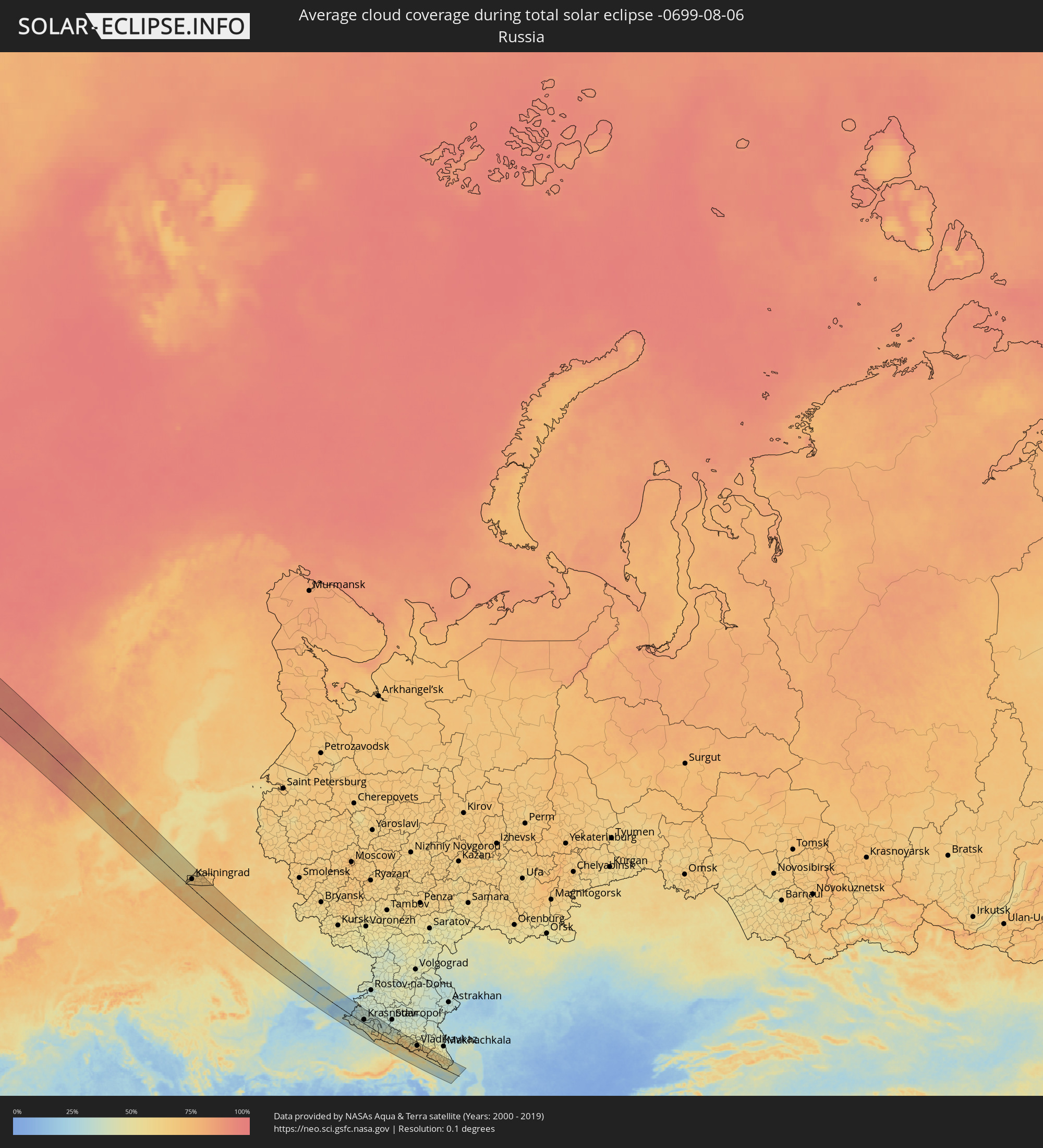 Russland
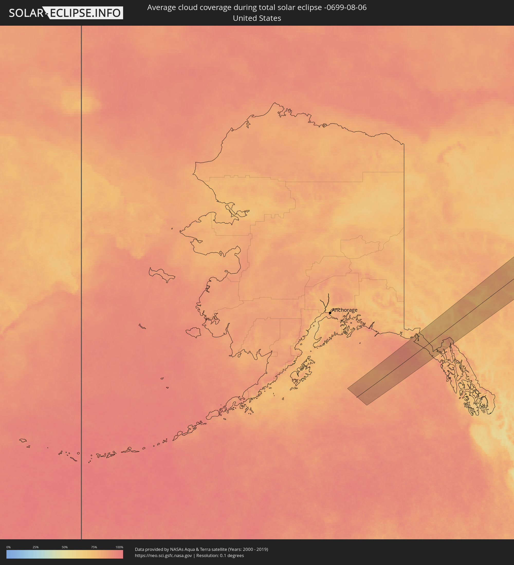 Vereinigte Staaten
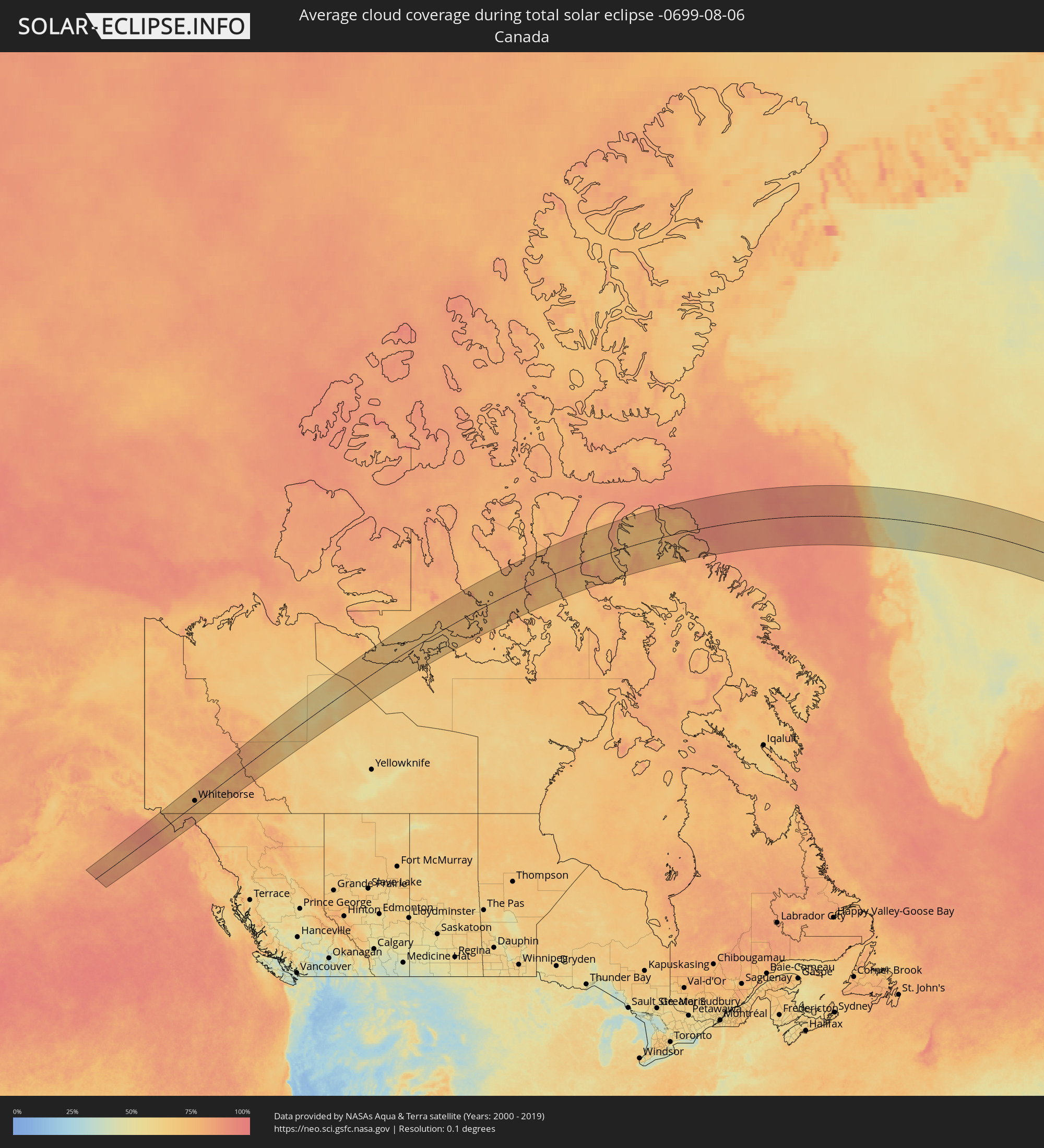 Kanada
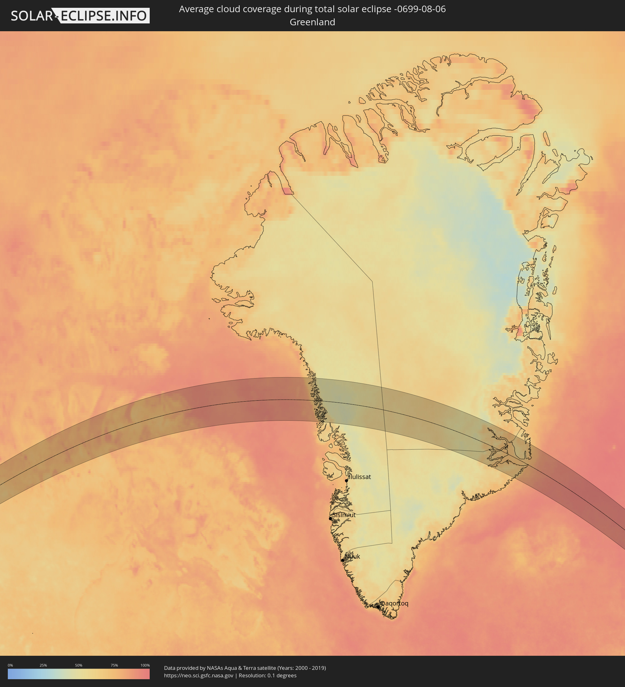 Grönland
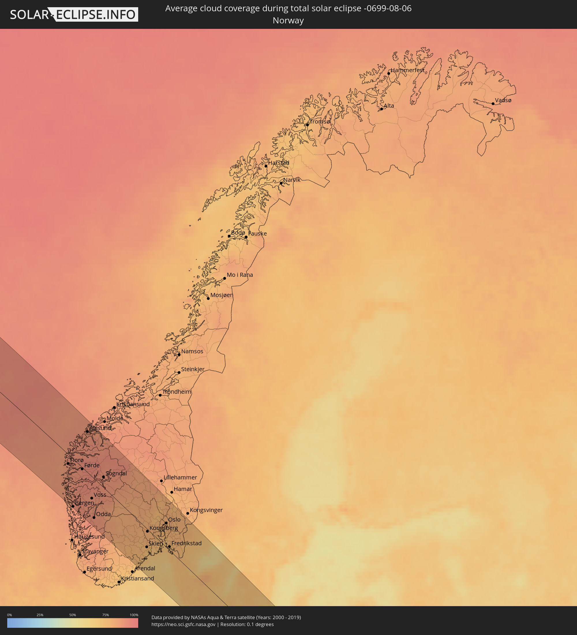 Norwegen
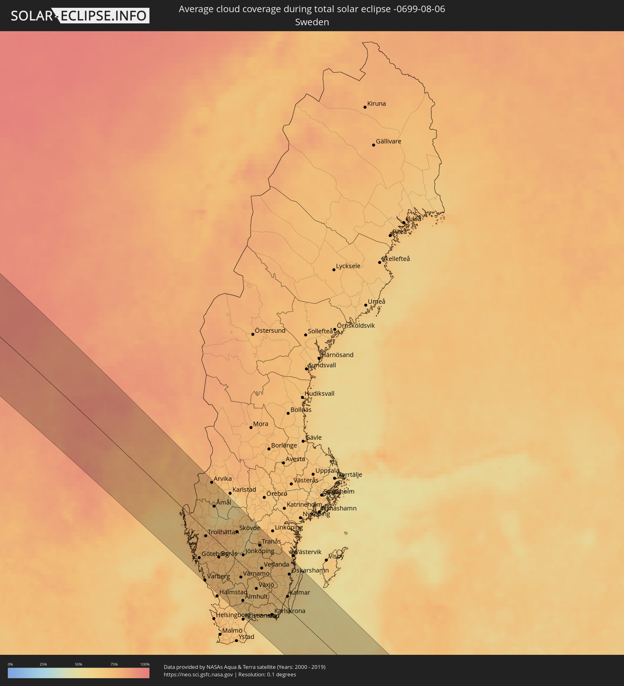 Schweden
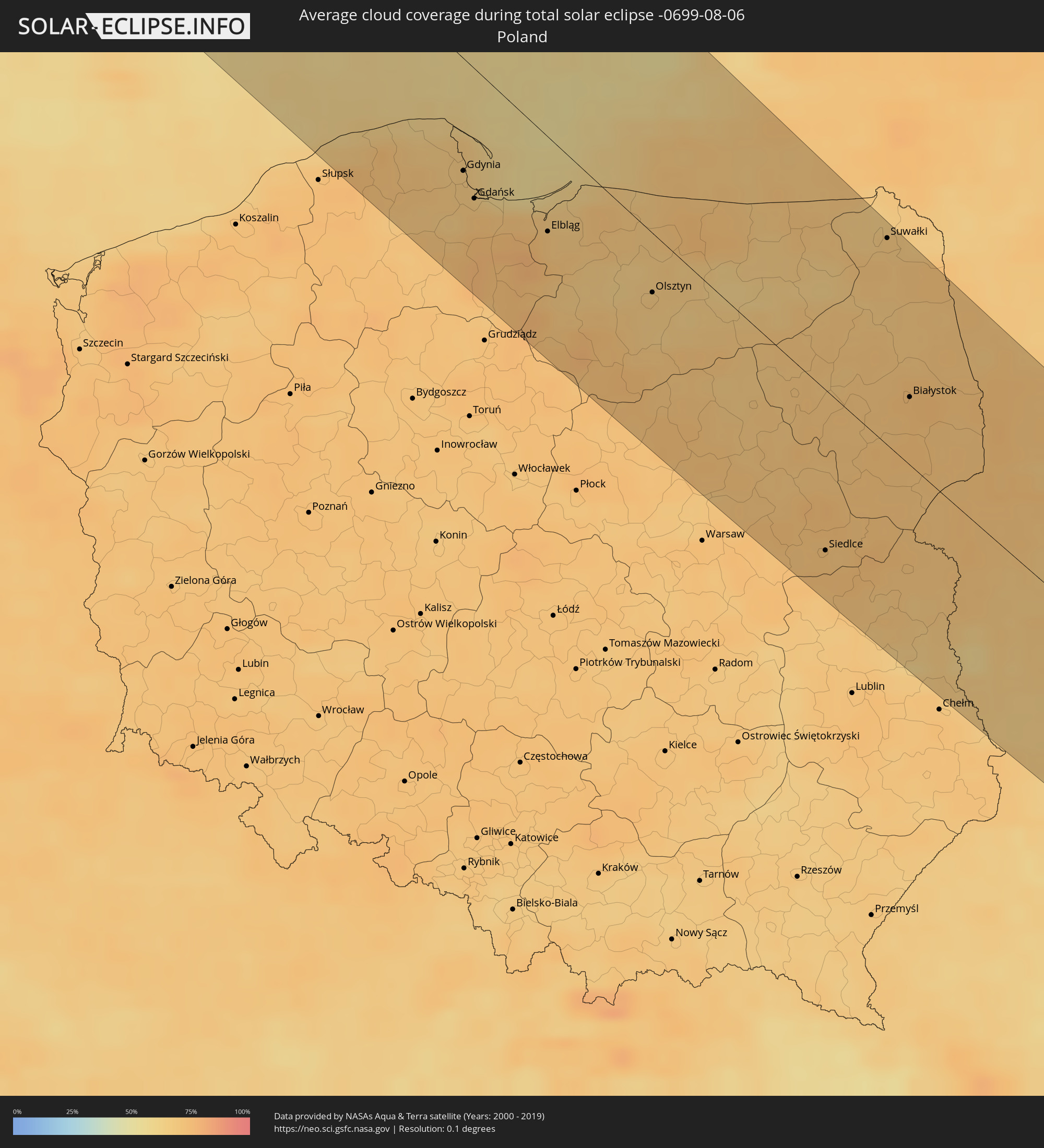 Polen
Polen
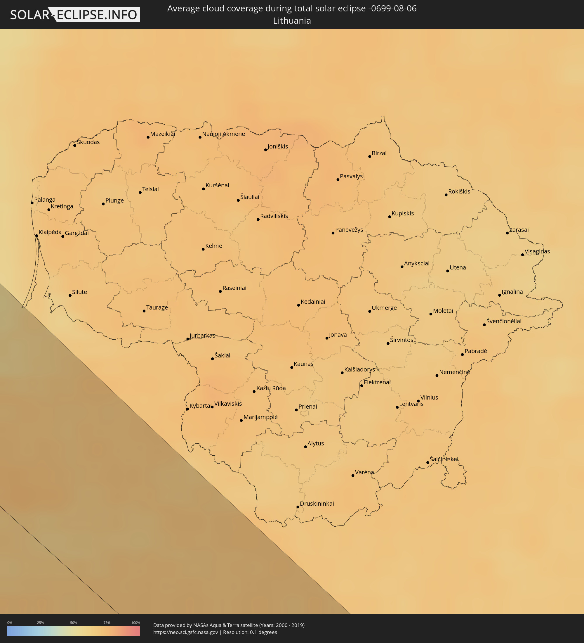 Litauen
 Ukraine
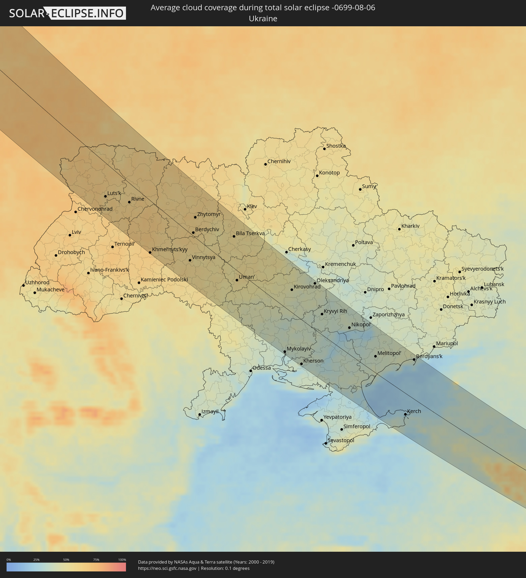
 Weißrussland
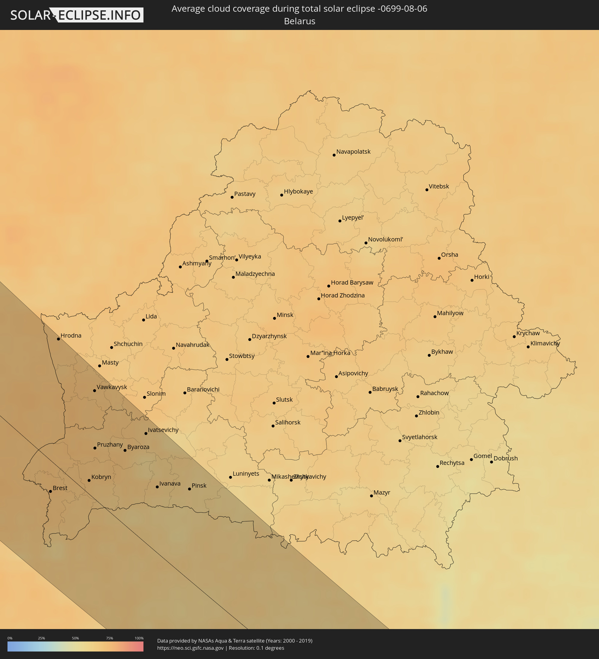
 Georgien
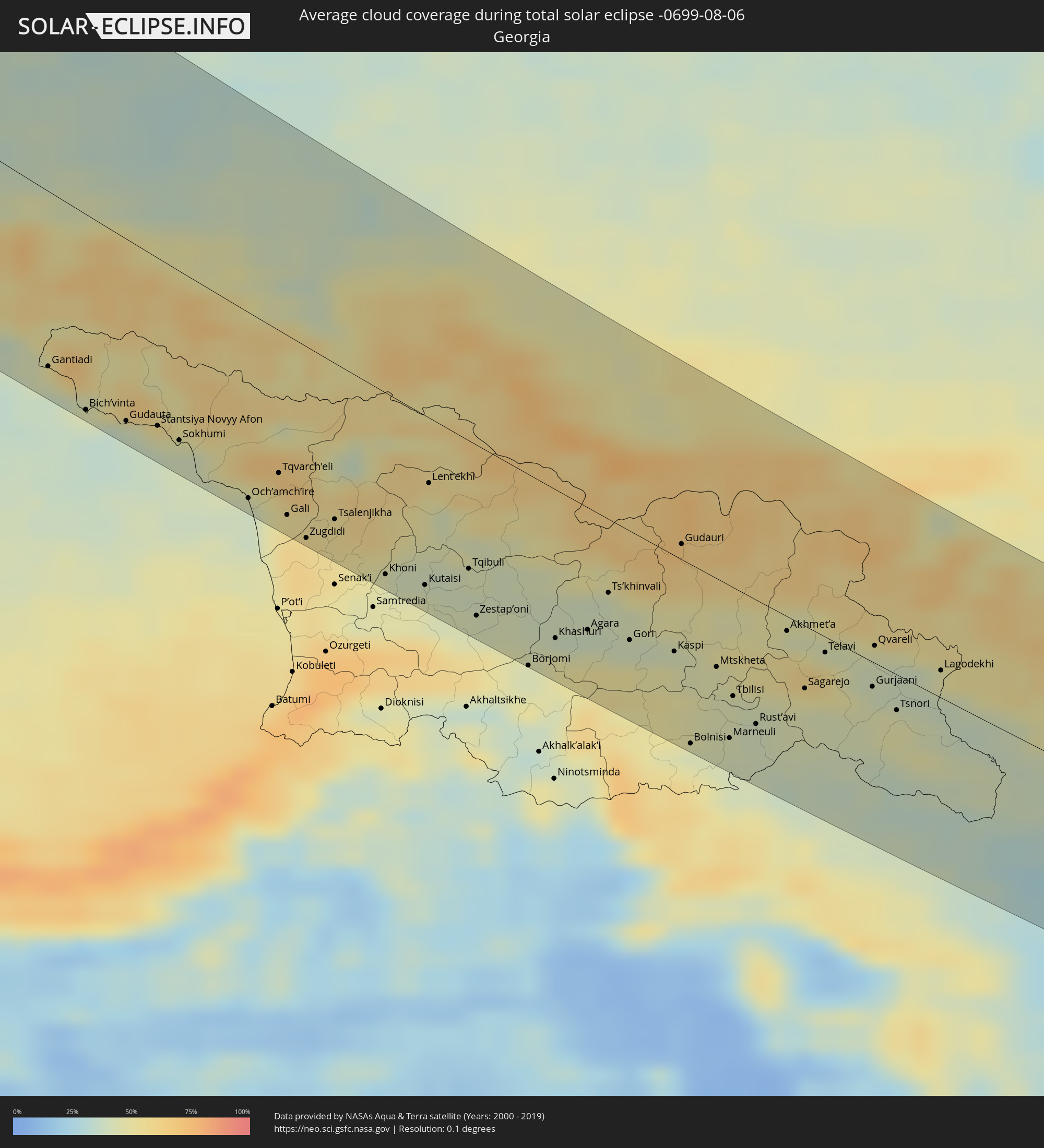
 Armenien
 Aserbaidschan
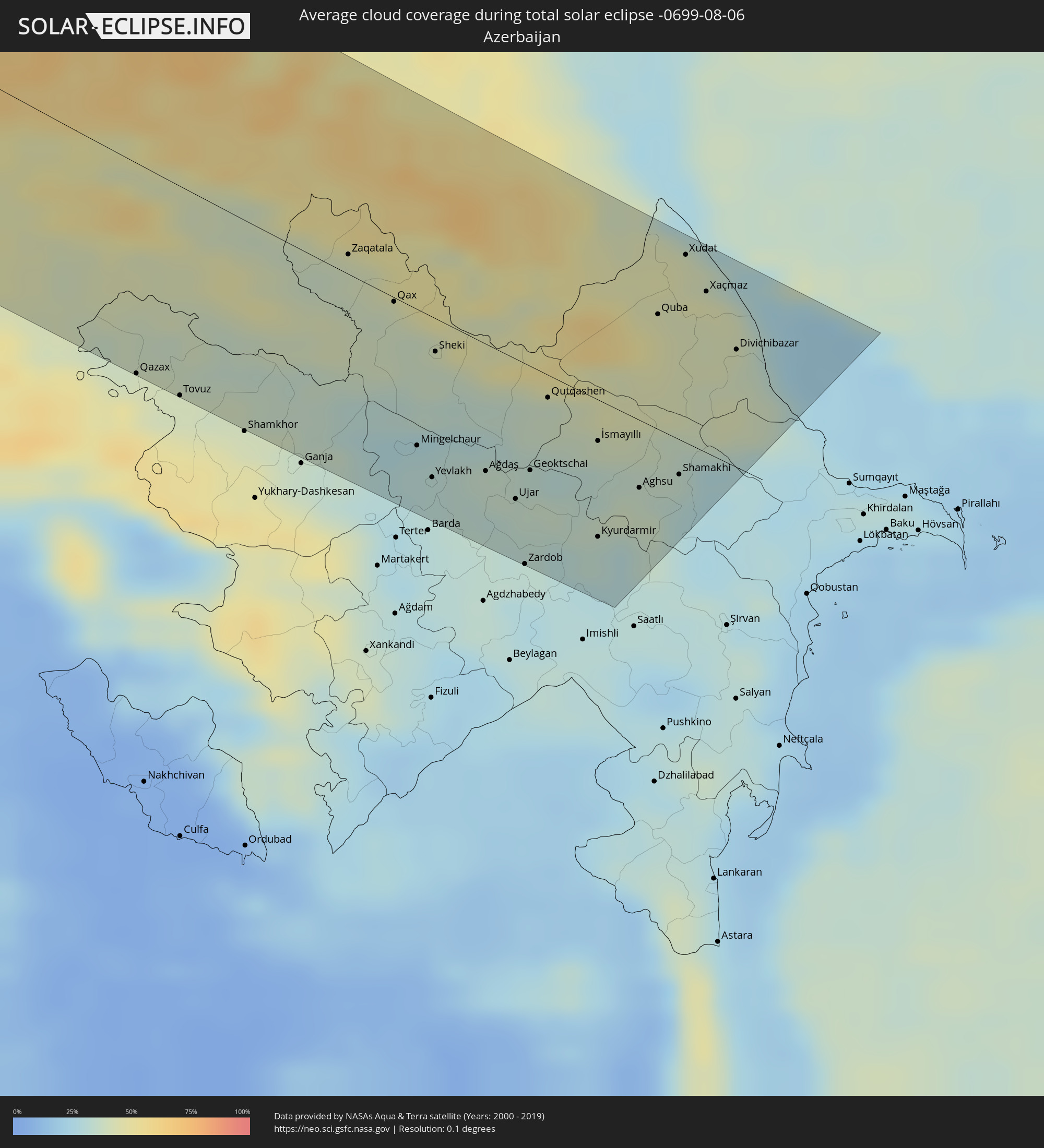
Orte im Finsternispfad
Die nachfolgene Tabelle zeigt Städte und Orte mit mehr als 5.000 Einwohnern, die sich im Finsternispfad befinden. Städte mit mehr als 100.000 Einwohnern sind dick gekennzeichnet. Mit einem Klick auf den Ort öffnet sich eine Detailkarte die die Lage des jeweiligen Ortes zusammen mit dem Verlauf der zentralen Finsternis präsentiert.
| Ort | Typ | Dauer der Verfinsterung | Ortszeit bei maximaler Verfinsterung | Entfernung zur Zentrallinie | Ø Bewölkung |
|
Whitehorse, Yukon
|
total | - | 05:48:39 UTC-08:00 | 20 km | 73% |
|
Florø, Sogn og Fjordane
|
total | - | 16:19:12 UTC+01:00 | 25 km | 88% |
|
Bergen, Hordaland
|
total | - | 16:21:27 UTC+01:00 | 111 km | 88% |
|
Førde, Sogn og Fjordane
|
total | - | 16:19:52 UTC+01:00 | 8 km | 91% |
|
Ålesund, Møre og Romsdal
|
total | - | 16:18:13 UTC+01:00 | 90 km | 88% |
|
Sogndal, Sogn og Fjordane
|
total | - | 16:20:50 UTC+01:00 | 28 km | 88% |
|
Notodden, Telemark
|
total | - | 16:24:47 UTC+01:00 | 31 km | 77% |
|
Skien, Telemark
|
total | - | 16:25:33 UTC+01:00 | 45 km | 74% |
|
Kongsberg, Buskerud
|
total | - | 16:24:45 UTC+01:00 | 17 km | 79% |
|
Drammen, Buskerud
|
total | - | 16:24:51 UTC+01:00 | 23 km | 78% |
|
Sandefjord, Vestfold
|
total | - | 16:25:57 UTC+01:00 | 27 km | 70% |
|
Hønefoss, Buskerud
|
total | - | 16:24:07 UTC+01:00 | 58 km | 76% |
|
Tønsberg, Vestfold
|
total | - | 16:25:47 UTC+01:00 | 8 km | 74% |
|
Moss, Østfold
|
total | - | 16:25:36 UTC+01:00 | 15 km | 74% |
|
Nesoddtangen, Akershus
|
total | - | 16:24:50 UTC+01:00 | 50 km | 79% |
|
Oslo, Oslo
|
total | - | 16:24:46 UTC+01:00 | 57 km | 79% |
|
Ås, Akershus
|
total | - | 16:25:14 UTC+01:00 | 42 km | 78% |
|
Ski, Akershus
|
total | - | 16:25:09 UTC+01:00 | 48 km | 78% |
|
Fredrikstad, Østfold
|
total | - | 16:26:06 UTC+01:00 | 16 km | 74% |
|
Lillestrøm, Akershus
|
total | - | 16:24:49 UTC+01:00 | 73 km | 79% |
|
Askim, Østfold
|
total | - | 16:25:32 UTC+01:00 | 47 km | 77% |
|
Jessheim, Akershus
|
total | - | 16:24:32 UTC+01:00 | 92 km | 79% |
|
Råholt, Akershus
|
total | - | 16:24:18 UTC+01:00 | 103 km | 77% |
|
Halden, Østfold
|
total | - | 16:26:27 UTC+01:00 | 23 km | 75% |
|
Uddevalla, Västra Götaland
|
total | - | 16:28:03 UTC+01:00 | 26 km | 75% |
|
Göteborg, Västra Götaland
|
total | - | 16:29:13 UTC+01:00 | 74 km | 74% |
|
Kungälv, Västra Götaland
|
total | - | 16:28:56 UTC+01:00 | 59 km | 75% |
|
Kungsbacka, Halland
|
total | - | 16:29:40 UTC+01:00 | 86 km | 71% |
|
Varberg, Halland
|
total | - | 16:30:25 UTC+01:00 | 109 km | 67% |
|
Lerum, Västra Götaland
|
total | - | 16:29:13 UTC+01:00 | 55 km | 72% |
|
Trollhättan, Västra Götaland
|
total | - | 16:28:18 UTC+01:00 | 13 km | 75% |
|
Alingsås, Västra Götaland
|
total | - | 16:29:02 UTC+01:00 | 32 km | 72% |
|
Borås, Västra Götaland
|
total | - | 16:29:34 UTC+01:00 | 35 km | 75% |
|
Lidköping, Västra Götaland
|
total | - | 16:28:14 UTC+01:00 | 43 km | 75% |
|
Skara, Västra Götaland
|
total | - | 16:28:33 UTC+01:00 | 43 km | 74% |
|
Falköping, Västra Götaland
|
total | - | 16:28:58 UTC+01:00 | 34 km | 74% |
|
Mariestad, Västra Götaland
|
total | - | 16:28:06 UTC+01:00 | 85 km | 70% |
|
Skövde, Västra Götaland
|
total | - | 16:28:41 UTC+01:00 | 61 km | 74% |
|
Ljungby, Kronoberg
|
total | - | 16:31:31 UTC+01:00 | 62 km | 72% |
|
Värnamo, Jönköping
|
total | - | 16:30:55 UTC+01:00 | 29 km | 71% |
|
Jönköping, Jönköping
|
total | - | 16:29:53 UTC+01:00 | 26 km | 69% |
|
Nässjö, Jönköping
|
total | - | 16:30:18 UTC+01:00 | 36 km | 71% |
|
Växjö, Kronoberg
|
total | - | 16:31:44 UTC+01:00 | 22 km | 69% |
|
Karlshamn, Blekinge
|
total | - | 16:33:02 UTC+01:00 | 77 km | 67% |
|
Karlskrona, Blekinge
|
total | - | 16:33:16 UTC+01:00 | 47 km | 64% |
|
Kalmar, Kalmar
|
total | - | 16:32:37 UTC+01:00 | 26 km | 67% |
|
Oskarshamn, Kalmar
|
total | - | 16:31:33 UTC+01:00 | 78 km | 67% |
|
Lębork, Pomeranian Voivodeship
|
total | - | 17:00:49 UTC+01:24 | 89 km | 71% |
|
Wejherowo, Pomeranian Voivodeship
|
total | - | 17:00:49 UTC+01:24 | 62 km | 69% |
|
Starogard Gdański, Pomeranian Voivodeship
|
total | - | 17:02:02 UTC+01:24 | 101 km | 74% |
|
Gdynia, Pomeranian Voivodeship
|
total | - | 17:01:03 UTC+01:24 | 56 km | 68% |
|
Gdańsk, Pomeranian Voivodeship
|
total | - | 17:01:22 UTC+01:24 | 66 km | 68% |
|
Tczew, Pomeranian Voivodeship
|
total | - | 17:01:52 UTC+01:24 | 80 km | 75% |
|
Kwidzyn, Pomeranian Voivodeship
|
total | - | 17:02:33 UTC+01:24 | 103 km | 72% |
|
Malbork, Pomeranian Voivodeship
|
total | - | 17:02:01 UTC+01:24 | 73 km | 73% |
|
Elbląg, Warmian-Masurian Voivodeship
|
total | - | 17:01:54 UTC+01:24 | 47 km | 70% |
|
Iława, Warmian-Masurian Voivodeship
|
total | - | 17:02:56 UTC+01:24 | 86 km | 72% |
|
Ostróda, Warmian-Masurian Voivodeship
|
total | - | 17:02:50 UTC+01:24 | 60 km | 70% |
|
Olsztyn, Warmian-Masurian Voivodeship
|
total | - | 17:02:48 UTC+01:24 | 35 km | 69% |
|
Kaliningrad, Kaliningrad
|
total | - | 16:37:10 UTC+01:00 | 47 km | 68% |
|
Ciechanów, Masovian Voivodeship
|
total | - | 17:04:25 UTC+01:24 | 99 km | 73% |
|
Ostrołęka, Masovian Voivodeship
|
total | - | 17:04:14 UTC+01:24 | 39 km | 70% |
|
Giżycko, Warmian-Masurian Voivodeship
|
total | - | 17:02:36 UTC+01:24 | 52 km | 67% |
|
Chernyakhovsk, Kaliningrad
|
total | - | 16:37:33 UTC+01:00 | 100 km | 69% |
|
Łomża, Podlasie
|
total | - | 17:04:09 UTC+01:24 | 18 km | 71% |
|
Siedlce, Masovian Voivodeship
|
total | - | 17:05:57 UTC+01:24 | 84 km | 72% |
|
Ełk, Warmian-Masurian Voivodeship
|
total | - | 17:03:04 UTC+01:24 | 60 km | 69% |
|
Łuków, Lublin Voivodeship
|
total | - | 17:06:23 UTC+01:24 | 101 km | 71% |
|
Suwałki, Podlasie
|
total | - | 17:02:40 UTC+01:24 | 106 km | 69% |
|
Augustów, Podlasie
|
total | - | 17:03:08 UTC+01:24 | 86 km | 68% |
|
Biała Podlaska, Lublin Voivodeship
|
total | - | 17:06:19 UTC+01:24 | 61 km | 70% |
|
Białystok, Podlasie
|
total | - | 17:04:24 UTC+01:24 | 35 km | 73% |
|
Brest, Brest
|
total | - | 17:32:17 UTC+01:50 | 28 km | 71% |
|
Kamyanyets, Brest
|
total | - | 17:31:46 UTC+01:50 | 20 km | 71% |
|
Hrodna, Grodnenskaya
|
total | - | 17:29:32 UTC+01:50 | 111 km | 72% |
|
Zhabinka, Brest
|
total | - | 17:32:09 UTC+01:50 | 7 km | 70% |
|
Vyalikaya Byerastavitsa, Grodnenskaya
|
total | - | 17:30:25 UTC+01:50 | 79 km | 73% |
|
Malaryta, Brest
|
total | - | 17:32:51 UTC+01:50 | 37 km | 68% |
|
Svislach, Grodnenskaya
|
total | - | 17:30:42 UTC+01:50 | 69 km | 74% |
|
Kobryn, Brest
|
total | - | 17:32:10 UTC+01:50 | 25 km | 69% |
|
Ros’, Grodnenskaya
|
total | - | 17:30:19 UTC+01:50 | 104 km | 72% |
|
Krasnasyel’ski, Grodnenskaya
|
total | - | 17:30:21 UTC+01:50 | 103 km | 72% |
|
Vawkavysk, Grodnenskaya
|
total | - | 17:30:32 UTC+01:50 | 95 km | 70% |
|
Pruzhany, Brest
|
total | - | 17:31:35 UTC+01:50 | 45 km | 73% |
|
Kovel’, Volyn
|
total | - | 17:45:59 UTC+02:02 | 56 km | 64% |
|
Zel’va, Grodnenskaya
|
total | - | 17:30:36 UTC+01:50 | 112 km | 69% |
|
Byaroza, Brest
|
total | - | 17:31:41 UTC+01:50 | 68 km | 70% |
|
Drahichyn, Brest
|
total | - | 17:32:18 UTC+01:50 | 50 km | 67% |
|
Byelaazyorsk, Brest
|
total | - | 17:31:48 UTC+01:50 | 71 km | 62% |
|
Ivatsevichy, Brest
|
total | - | 17:31:25 UTC+01:50 | 98 km | 66% |
|
Luts’k, Volyn
|
total | - | 17:46:49 UTC+02:02 | 67 km | 62% |
|
Ivanava, Brest
|
total | - | 17:32:24 UTC+01:50 | 59 km | 62% |
|
Pinsk, Brest
|
total | - | 17:32:29 UTC+01:50 | 83 km | 62% |
|
Rivne, Rivne
|
total | - | 17:47:07 UTC+02:02 | 39 km | 62% |
|
Stolin, Brest
|
total | - | 17:32:56 UTC+01:50 | 97 km | 61% |
|
Khmel’nyts’kyy, Khmelnytskyi
|
total | - | 17:49:10 UTC+02:02 | 108 km | 66% |
|
Novohrad-Volyns’kyy, Zhytomyr
|
total | - | 17:47:14 UTC+02:02 | 23 km | 61% |
|
Vinnytsya, Vinnyts'ka
|
total | - | 17:49:31 UTC+02:02 | 57 km | 58% |
|
Berdychiv, Zhytomyr
|
total | - | 17:48:25 UTC+02:02 | 8 km | 62% |
|
Korosten’, Zhytomyr
|
total | - | 17:46:39 UTC+02:02 | 102 km | 64% |
|
Zhytomyr, Zhytomyr
|
total | - | 17:47:49 UTC+02:02 | 45 km | 60% |
|
Bila Tserkva, Kiev
|
total | - | 17:48:34 UTC+02:02 | 67 km | 55% |
|
Uman’, Cherkasy
|
total | - | 17:50:17 UTC+02:02 | 23 km | 53% |
|
Pervomays’k, Mykolaiv
|
total | - | 17:51:24 UTC+02:02 | 58 km | 43% |
|
Smila, Cherkasy
|
total | - | 17:49:27 UTC+02:02 | 96 km | 50% |
|
Mykolayiv, Mykolaiv
|
total | - | 17:53:02 UTC+02:02 | 102 km | 31% |
|
Kirovohrad, Kirovohrad
|
total | - | 17:50:34 UTC+02:02 | 52 km | 43% |
|
Kherson, Kherson
|
total | - | 17:53:28 UTC+02:02 | 101 km | 32% |
|
Oleksandriya, Kirovohrad
|
total | - | 17:50:15 UTC+02:02 | 104 km | 41% |
|
Kryvyi Rih, Dnipropetrovsk
|
total | - | 17:51:26 UTC+02:02 | 46 km | 38% |
|
Nikopol’, Dnipropetrovsk
|
total | - | 17:51:51 UTC+02:02 | 61 km | 27% |
|
Energodar, Zaporizhia
|
total | - | 17:51:56 UTC+02:02 | 67 km | 27% |
|
Melitopol’, Zaporizhia
|
total | - | 17:52:50 UTC+02:02 | 39 km | 36% |
|
Kerch, Republic of Crimea
|
total | - | 18:08:50 UTC+02:16 | 51 km | 32% |
|
Berdyans’k, Zaporizhia
|
total | - | 17:52:44 UTC+02:02 | 94 km | 32% |
|
Anapa, Krasnodarskiy
|
total | - | 18:23:39 UTC+02:30 | 61 km | 29% |
|
Novorossiysk, Krasnodarskiy
|
total | - | 18:23:48 UTC+02:30 | 55 km | 37% |
|
Krymsk, Krasnodarskiy
|
total | - | 18:23:27 UTC+02:30 | 30 km | 35% |
|
Gelendzhik, Krasnodarskiy
|
total | - | 18:23:58 UTC+02:30 | 56 km | 35% |
|
Slavyansk-na-Kubani, Krasnodarskiy
|
total | - | 18:22:56 UTC+02:30 | 12 km | 35% |
|
Timashëvsk, Krasnodarskiy
|
total | - | 18:22:14 UTC+02:30 | 80 km | 35% |
|
Krasnodar, Krasnodarskiy
|
total | - | 18:23:03 UTC+02:30 | 34 km | 31% |
|
Tuapse, Krasnodarskiy
|
total | - | 18:24:23 UTC+02:30 | 57 km | 38% |
|
Ust’-Labinsk, Krasnodarskiy
|
total | - | 18:22:39 UTC+02:30 | 75 km | 33% |
|
Sochi, Krasnodarskiy
|
total | - | 18:24:57 UTC+02:30 | 80 km | 37% |
|
Belorechensk, Krasnodarskiy
|
total | - | 18:23:14 UTC+02:30 | 41 km | 36% |
|
Adler, Krasnodarskiy
|
total | - | 18:25:08 UTC+02:30 | 85 km | 38% |
|
Maykop, Adygeya
|
total | - | 18:23:25 UTC+02:30 | 36 km | 38% |
|
Kurganinsk, Krasnodarskiy
|
total | - | 18:22:54 UTC+02:30 | 81 km | 35% |
|
Labinsk, Krasnodarskiy
|
total | - | 18:23:13 UTC+02:30 | 65 km | 33% |
|
Sokhumi, Abkhazia
|
total | - | 18:54:20 UTC+02:59 | 82 km | 41% |
|
Och’amch’ire, Abkhazia
|
total | - | 18:54:35 UTC+02:59 | 90 km | 39% |
|
Tqvarch'eli, Abkhazia
|
total | - | 18:54:21 UTC+02:59 | 70 km | 58% |
|
Gali, Abkhazia
|
total | - | 18:54:38 UTC+02:59 | 90 km | 55% |
|
Zugdidi, Samegrelo and Zemo Svaneti
|
total | - | 18:54:45 UTC+02:59 | 94 km | 57% |
|
Cherkessk, Karachayevo-Cherkesiya
|
total | - | 18:23:25 UTC+02:30 | 79 km | 37% |
|
Khoni, Imereti
|
total | - | 18:54:50 UTC+02:59 | 90 km | 45% |
|
Kutaisi, Imereti
|
total | - | 18:54:49 UTC+02:59 | 86 km | 43% |
|
Kislovodsk, Stavropol'skiy
|
total | - | 18:23:39 UTC+02:30 | 79 km | 52% |
|
Lent’ekhi, Racha-Lechkhumi and Kvemo Svaneti
|
total | - | 18:54:06 UTC+02:59 | 33 km | 50% |
|
Yessentuki, Stavropol'skiy
|
total | - | 18:23:26 UTC+02:30 | 97 km | 48% |
|
Tqibuli
|
total | - | 18:54:36 UTC+02:59 | 64 km | 43% |
|
Zestap’oni, Imereti
|
total | - | 18:54:54 UTC+02:59 | 85 km | 43% |
|
Borjomi, Samtskhe-Javakheti
|
total | - | 18:55:07 UTC+02:59 | 95 km | 43% |
|
Surami
|
total | - | 18:54:51 UTC+02:59 | 73 km | 46% |
|
Khashuri, Shida Kartli
|
total | - | 18:54:52 UTC+02:59 | 74 km | 46% |
|
Nal’chik, Kabardino-Balkariya
|
total | - | 18:23:56 UTC+02:30 | 74 km | 52% |
|
Ts’khinvali, Shida Kartli
|
total | - | 18:54:26 UTC+02:59 | 41 km | 41% |
|
Gori, Shida Kartli
|
total | - | 18:54:42 UTC+02:59 | 55 km | 41% |
|
Kaspi, Shida Kartli
|
total | - | 18:54:40 UTC+02:59 | 52 km | 47% |
|
Bolnisi, Kvemo Kartli
|
total | - | 18:55:15 UTC+02:59 | 91 km | 47% |
|
Vladikavkaz, North Ossetia
|
total | - | 18:24:12 UTC+02:30 | 73 km | 64% |
|
Nazran’, Ingushetiya
|
total | - | 18:23:55 UTC+02:30 | 95 km | 54% |
|
Marneuli, Kvemo Kartli
|
total | - | 18:55:07 UTC+02:59 | 81 km | 42% |
|
Tbilisi, T'bilisi
|
total | - | 18:54:50 UTC+02:59 | 57 km | 44% |
|
Rust’avi, Kvemo Kartli
|
total | - | 18:54:57 UTC+02:59 | 65 km | 41% |
|
Gardabani, Kvemo Kartli
|
total | - | 18:55:02 UTC+02:59 | 68 km | 41% |
|
Sagarejo, Kakheti
|
total | - | 18:54:35 UTC+02:59 | 32 km | 44% |
|
Qazax, Qazax
|
total | - | 19:15:38 UTC+03:19 | 94 km | 41% |
|
Aghstafa, Ağstafa
|
total | - | 19:15:33 UTC+03:19 | 88 km | 40% |
|
Telavi, Kakheti
|
total | - | 18:54:18 UTC+02:59 | 8 km | 51% |
|
Tovuz, Tovuz
|
total | - | 19:15:39 UTC+03:19 | 93 km | 40% |
|
Belokany, Balakǝn
|
total | - | 19:14:24 UTC+03:19 | 9 km | 40% |
|
Zaqatala, Zaqatala
|
total | - | 19:14:26 UTC+03:19 | 9 km | 39% |
|
Qax, Qǝx
|
total | - | 19:14:35 UTC+03:19 | 7 km | 39% |
|
Mingelchaur, Mingǝcevir
|
total | - | 19:15:22 UTC+03:19 | 63 km | 29% |
|
Yevlakh, Yevlax City
|
total | - | 19:15:31 UTC+03:19 | 73 km | 31% |
|
Sheki, Shaki City
|
total | - | 19:14:47 UTC+03:19 | 28 km | 37% |
|
Ağdaş, Ağdaş
|
total | - | 19:15:20 UTC+03:19 | 58 km | 34% |
|
Ujar, Ucar
|
total | - | 19:15:25 UTC+03:19 | 64 km | 34% |
|
Zardob, Zərdab
|
total | - | 19:15:46 UTC+03:19 | 92 km | 31% |
|
Geoktschai, Göyçay
|
total | - | 19:15:13 UTC+03:19 | 47 km | 33% |
|
Qutqashen, Qǝbǝlǝ
|
total | - | 19:14:46 UTC+03:19 | 10 km | 37% |
|
Kyurdarmir, Kürdǝmir
|
total | - | 19:15:26 UTC+03:19 | 63 km | 32% |
|
İsmayıllı, İsmayıllı
|
total | - | 19:14:53 UTC+03:19 | 19 km | 39% |
|
Aghsu, Ağsu
|
total | - | 19:15:02 UTC+03:19 | 32 km | 36% |
|
Qusar, Qusar
|
total | - | 19:13:57 UTC+03:19 | 56 km | 46% |
|
Quba, Quba
|
total | - | 19:14:00 UTC+03:19 | 52 km | 44% |
|
Shamakhi, Şamaxı
|
total | - | 19:14:51 UTC+03:19 | 26 km | 32% |
|
Xudat, Xaçmaz
|
total | - | 19:13:35 UTC+03:19 | 85 km | 42% |
|
Xaçmaz, Xaçmaz
|
total | - | 19:13:45 UTC+03:19 | 74 km | 44% |
|
Divichibazar, Shabran
|
total | - | 19:14:00 UTC+03:19 | 57 km | 39% |