Totale Sonnenfinsternis vom 24.06.-0874
| Wochentag: | Mittwoch |
| Maximale Dauer der Verfinsterung: | 03m13s |
| Maximale Breite des Finsternispfades: | 117 km |
| Saroszyklus: | 42 |
| Bedeckungsgrad: | 100% |
| Magnitude: | 1.0343 |
| Gamma: | 0.1513 |
Wo kann man die Sonnenfinsternis vom 24.06.-0874 sehen?
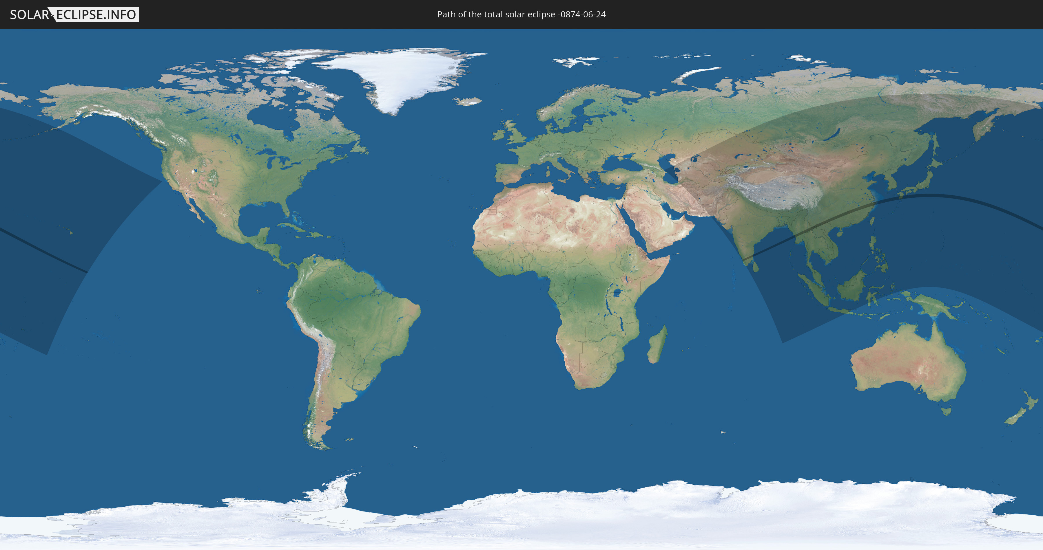
Die Sonnenfinsternis am 24.06.-0874 kann man in 53 Ländern als partielle Sonnenfinsternis beobachten.
Der Finsternispfad verläuft durch 7 Länder. Nur in diesen Ländern ist sie als totale Sonnenfinsternis zu sehen.
In den folgenden Ländern ist die Sonnenfinsternis total zu sehen
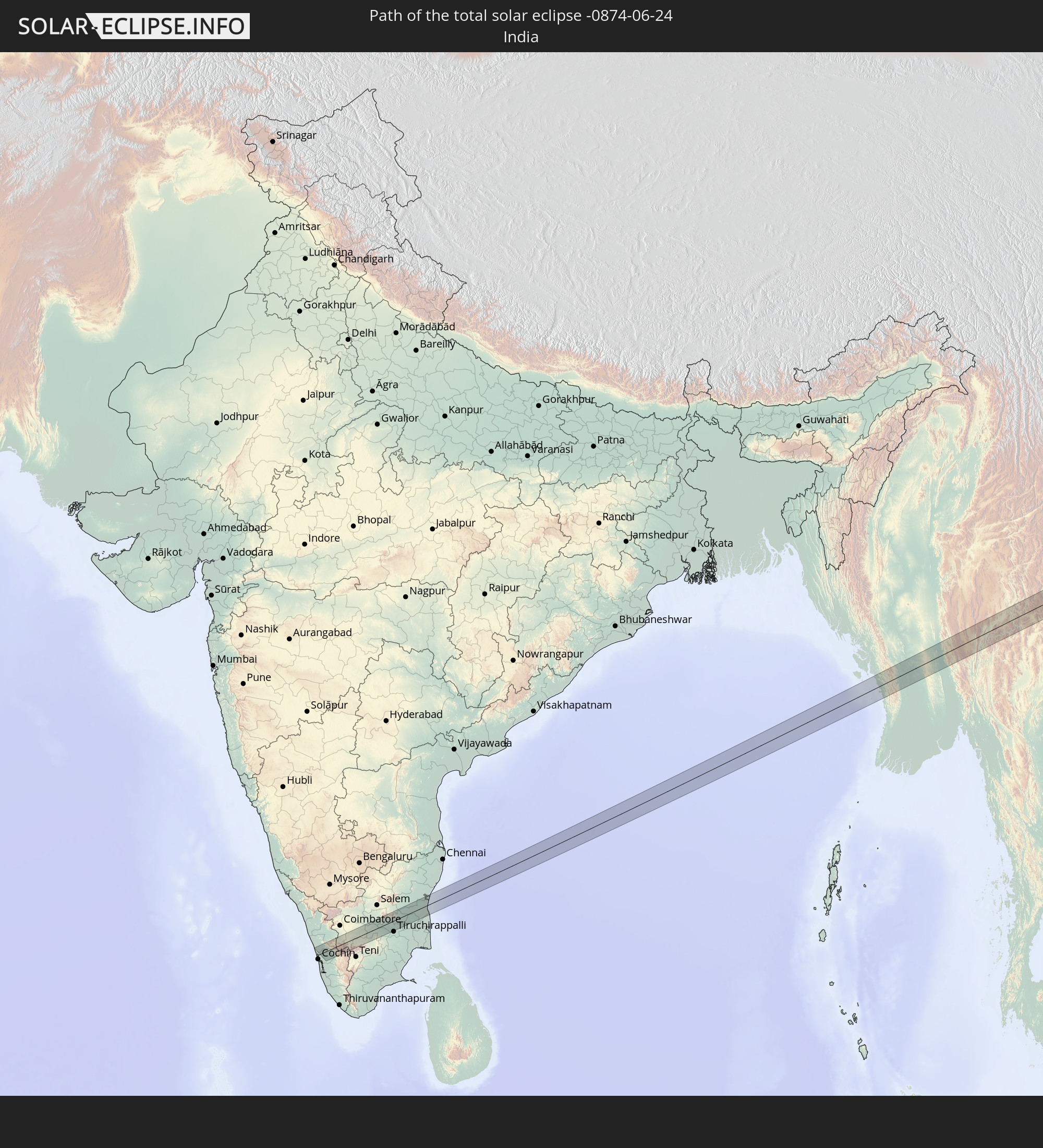 Indien
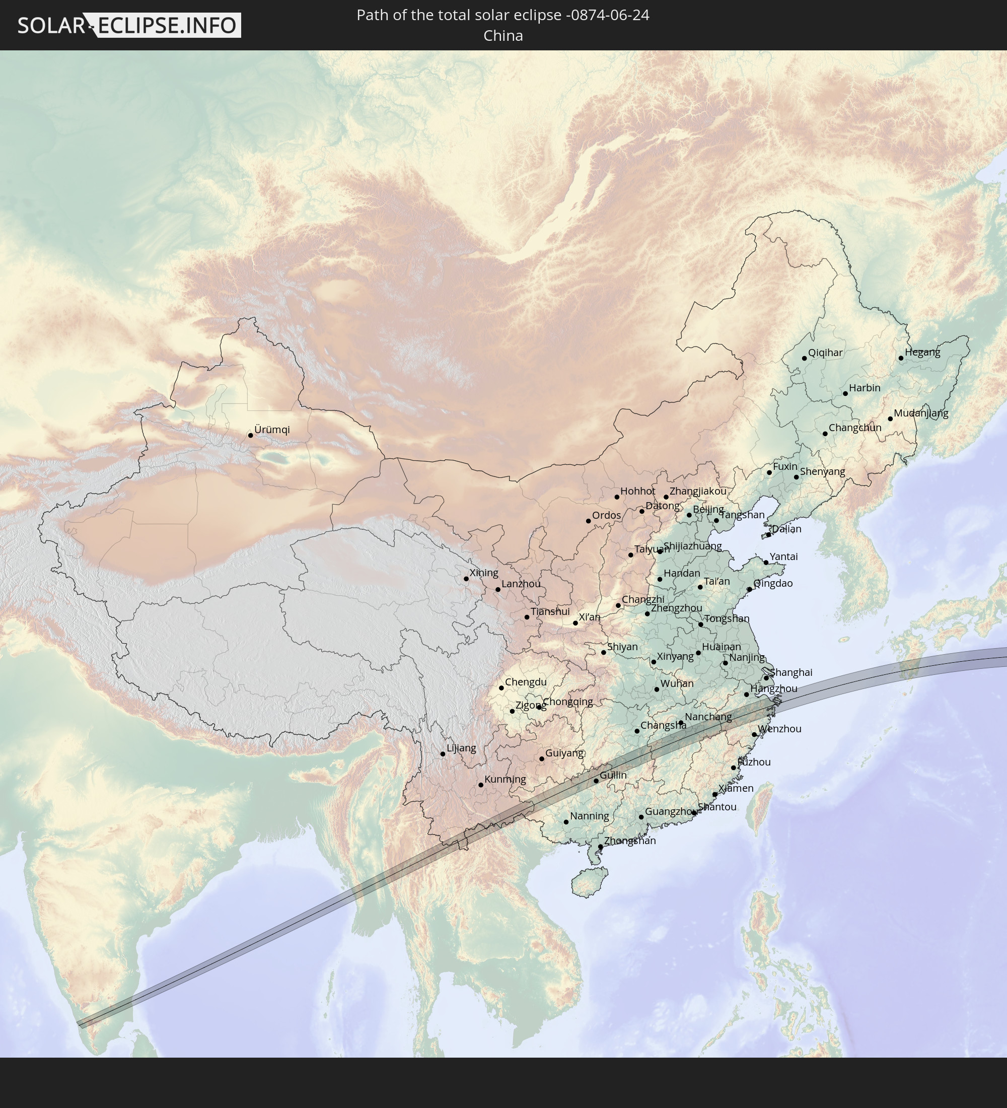 Volksrepublik China
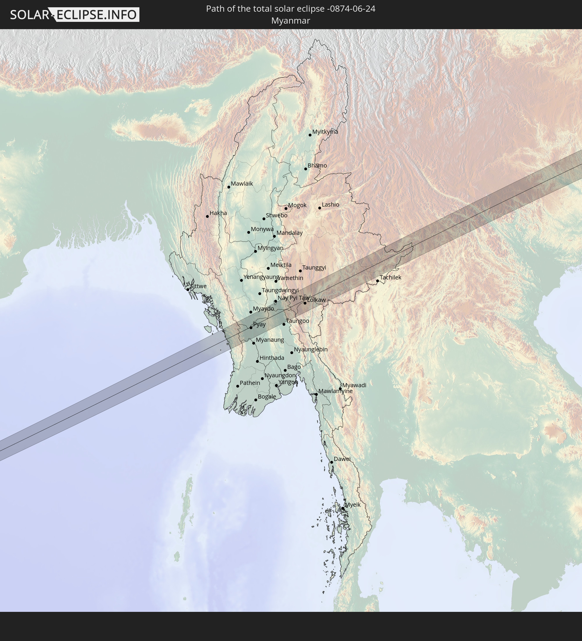 Myanmar
 Thailand
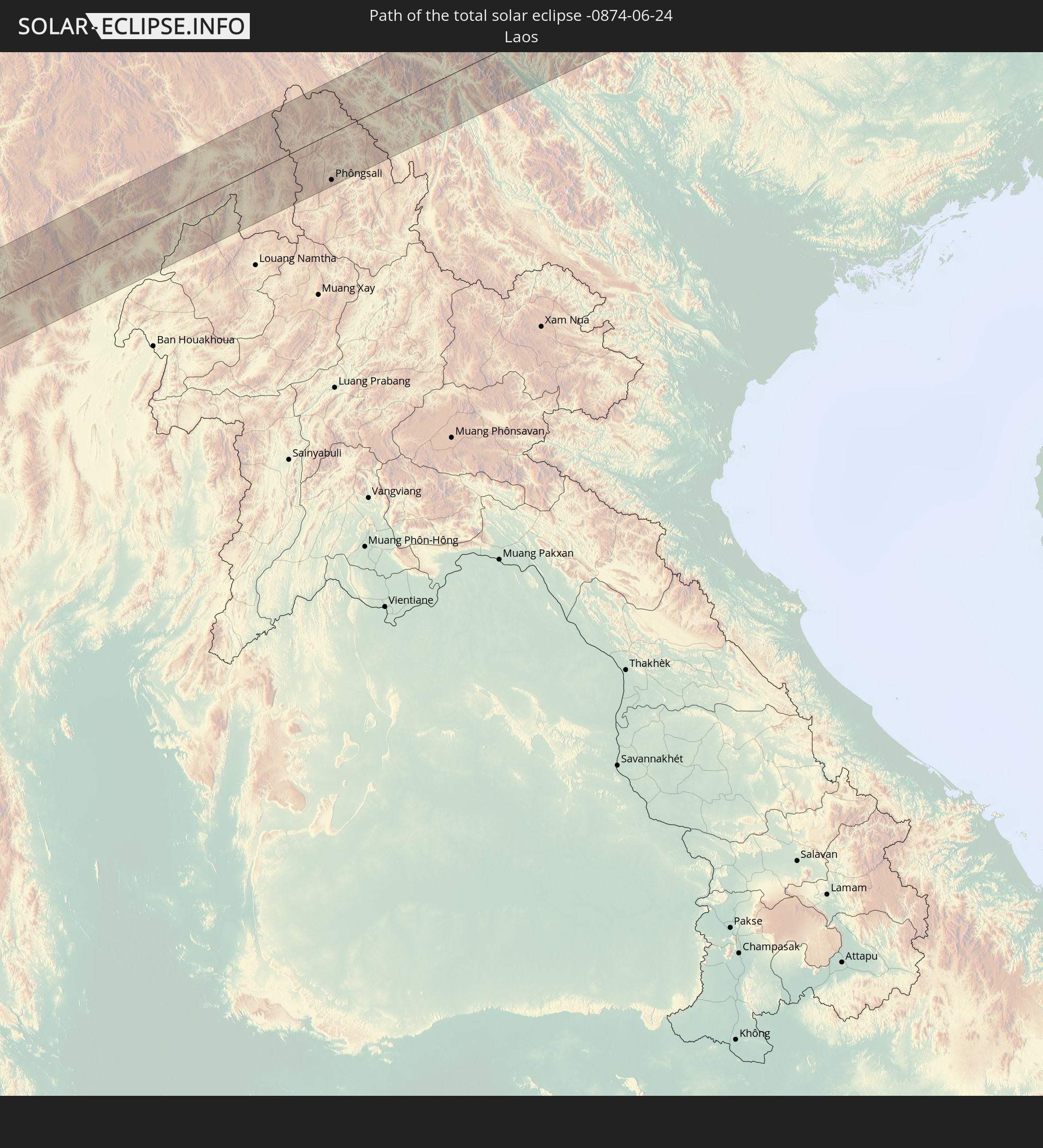 Laos
Laos
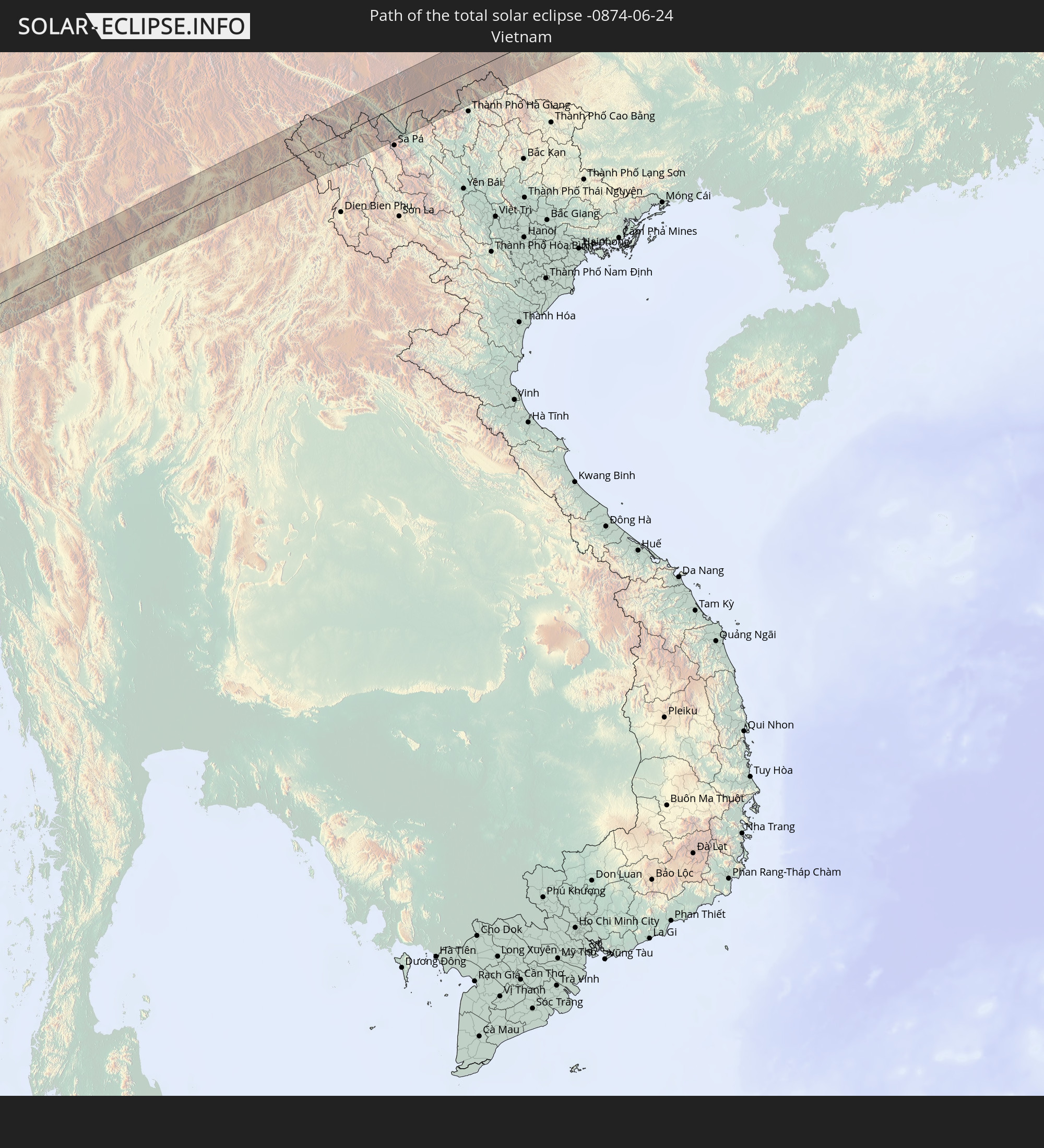 Vietnam
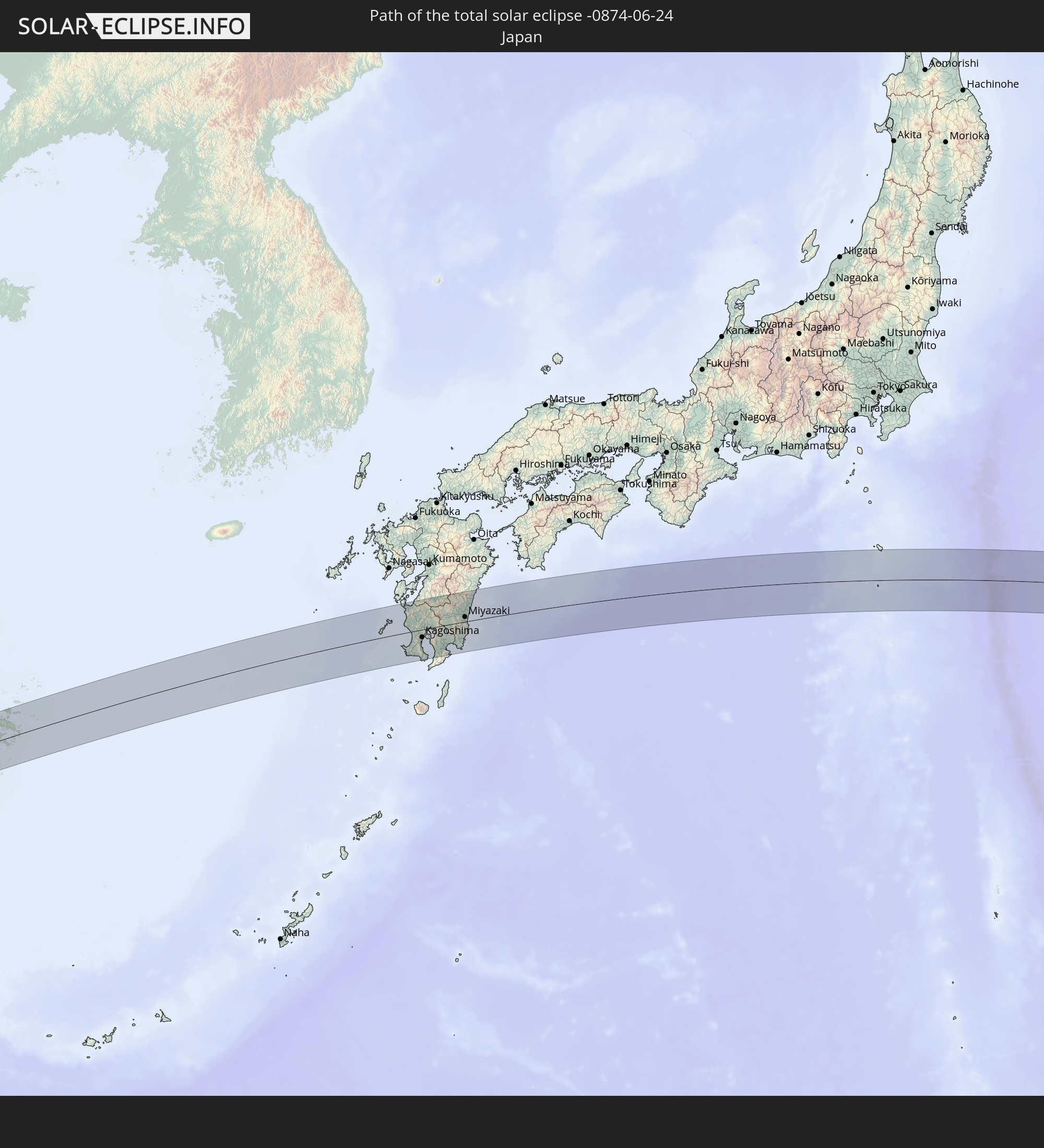 Japan
Japan
In den folgenden Ländern ist die Sonnenfinsternis partiell zu sehen
 Fidschi
 Russland
 Vereinigte Staaten
 United States Minor Outlying Islands
 Wallis und Futuna
 Tonga
Tonga
 Kiribati
 Samoa
Samoa
 Tokelau
 Amerikanisch-Samoa
 Niue
Niue
 Cookinseln
 Iran
Iran
 Aserbaidschan
 Kasachstan
 Turkmenistan
 Usbekistan
 Afghanistan
 Pakistan
 Tadschikistan
 Indien
 Kirgisistan
 Volksrepublik China
 Sri Lanka
 Nepal
Nepal
 Mongolei
 Bangladesch
 Bhutan
 Myanmar
 Indonesien
 Kokosinseln
 Thailand
 Malaysia
 Laos
Laos
 Vietnam
 Kambodscha
 Singapur
 Weihnachtsinsel
 Macau
Macau
 Hongkong
 Brunei
 Taiwan
 Philippinen
 Japan
Japan
 Nordkorea
 Südkorea
 Palau
Palau
 Föderierte Staaten von Mikronesien
 Guam
Guam
 Nördliche Marianen
 Marshallinseln
 Nauru
Nauru
 Tuvalu
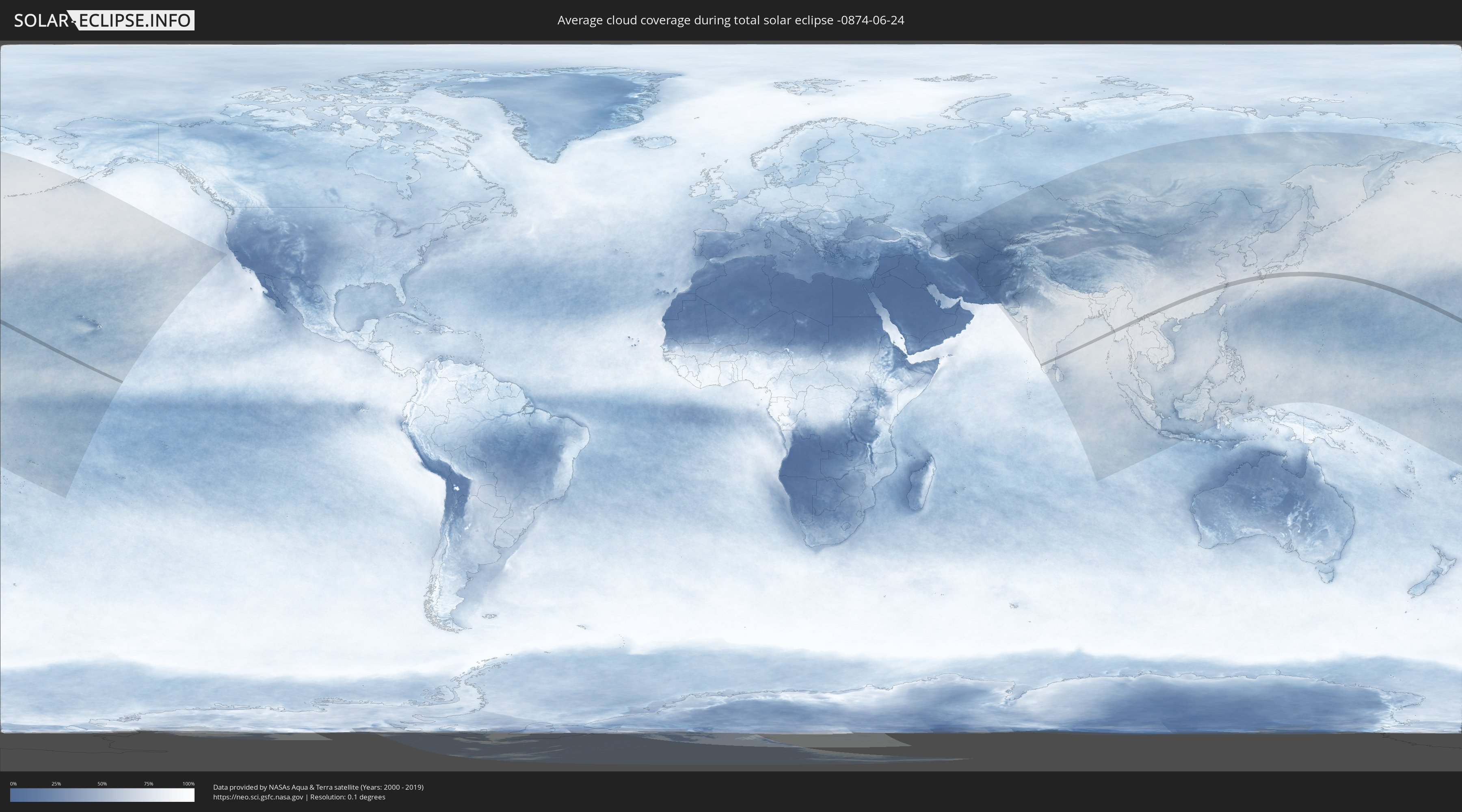
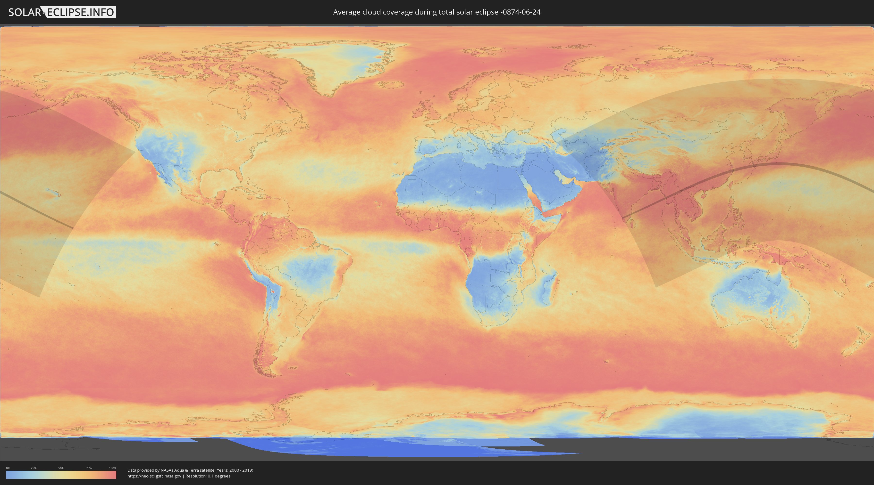
Wie wird das Wetter während der totalen Sonnenfinsternis am 24.06.-0874?
Wo ist der beste Ort, um die totale Sonnenfinsternis vom 24.06.-0874 zu beobachten?
Die folgenden Karten zeigen die durchschnittliche Bewölkung für den Tag, an dem die totale Sonnenfinsternis
stattfindet. Mit Hilfe der Karten lässt sich der Ort entlang des Finsternispfades eingrenzen,
der die besten Aussichen auf einen klaren wolkenfreien Himmel bietet.
Trotzdem muss man immer lokale Gegenenheiten beachten und sollte sich genau über das Wetter an seinem
gewählten Beobachtungsort informieren.
Die Daten stammen von den beiden NASA-Satelliten
AQUA und TERRA
und wurden über einen Zeitraum von 19 Jahren (2000 - 2019) gemittelt.
Detaillierte Länderkarten
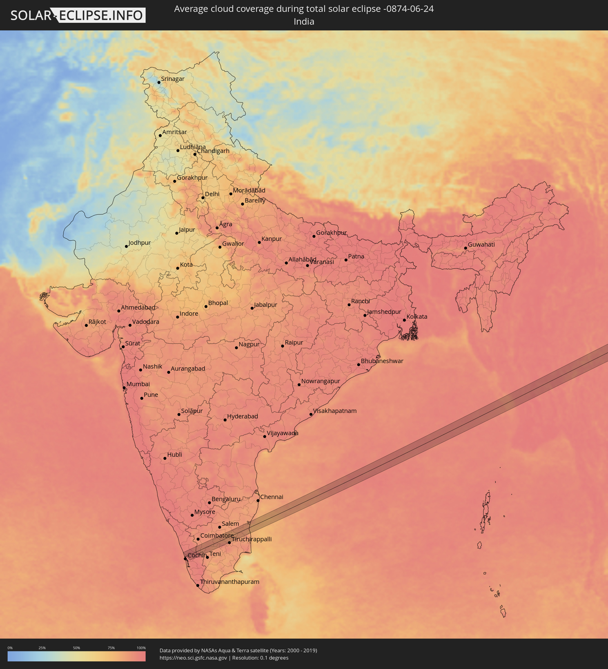 Indien
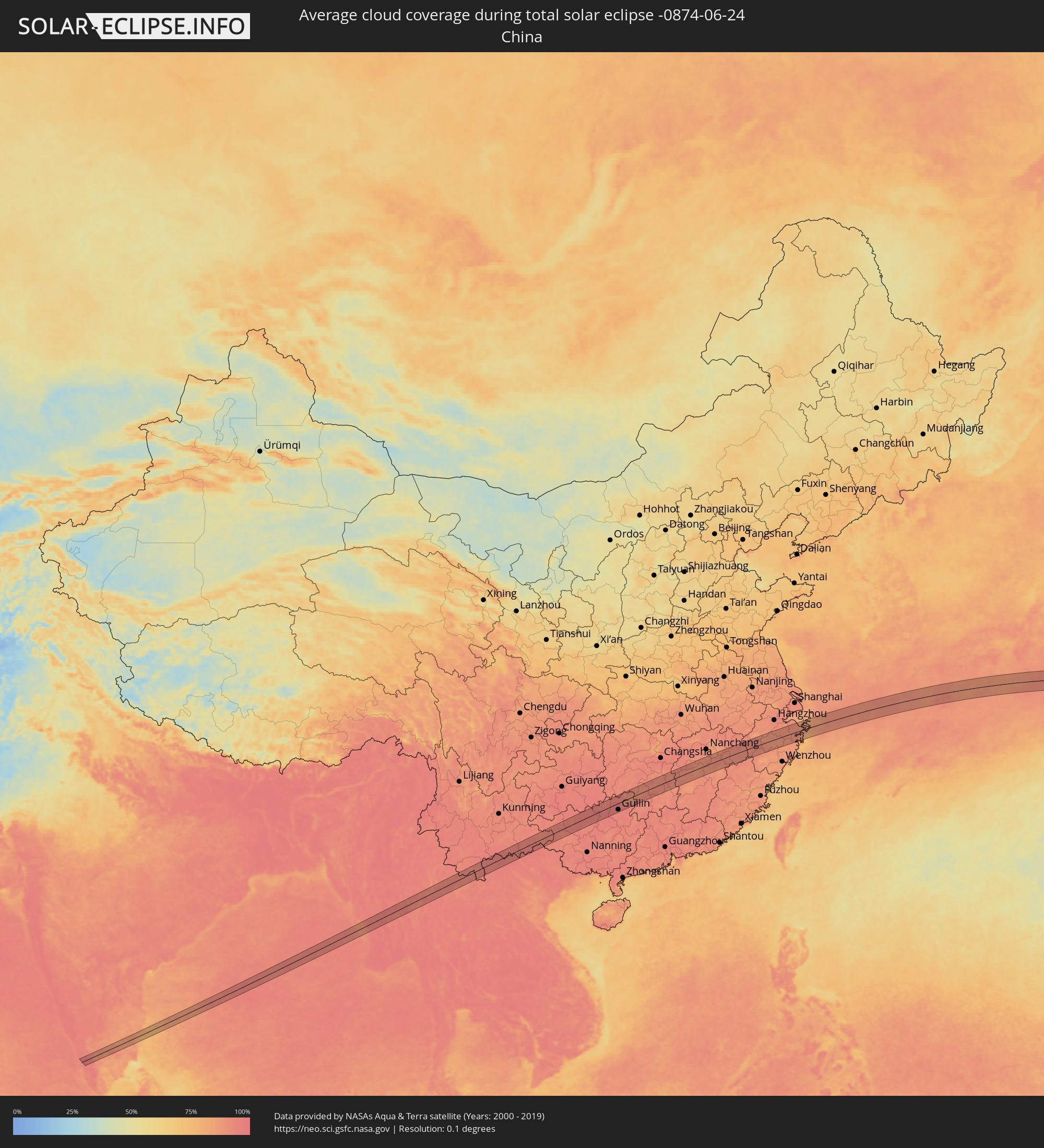 Volksrepublik China
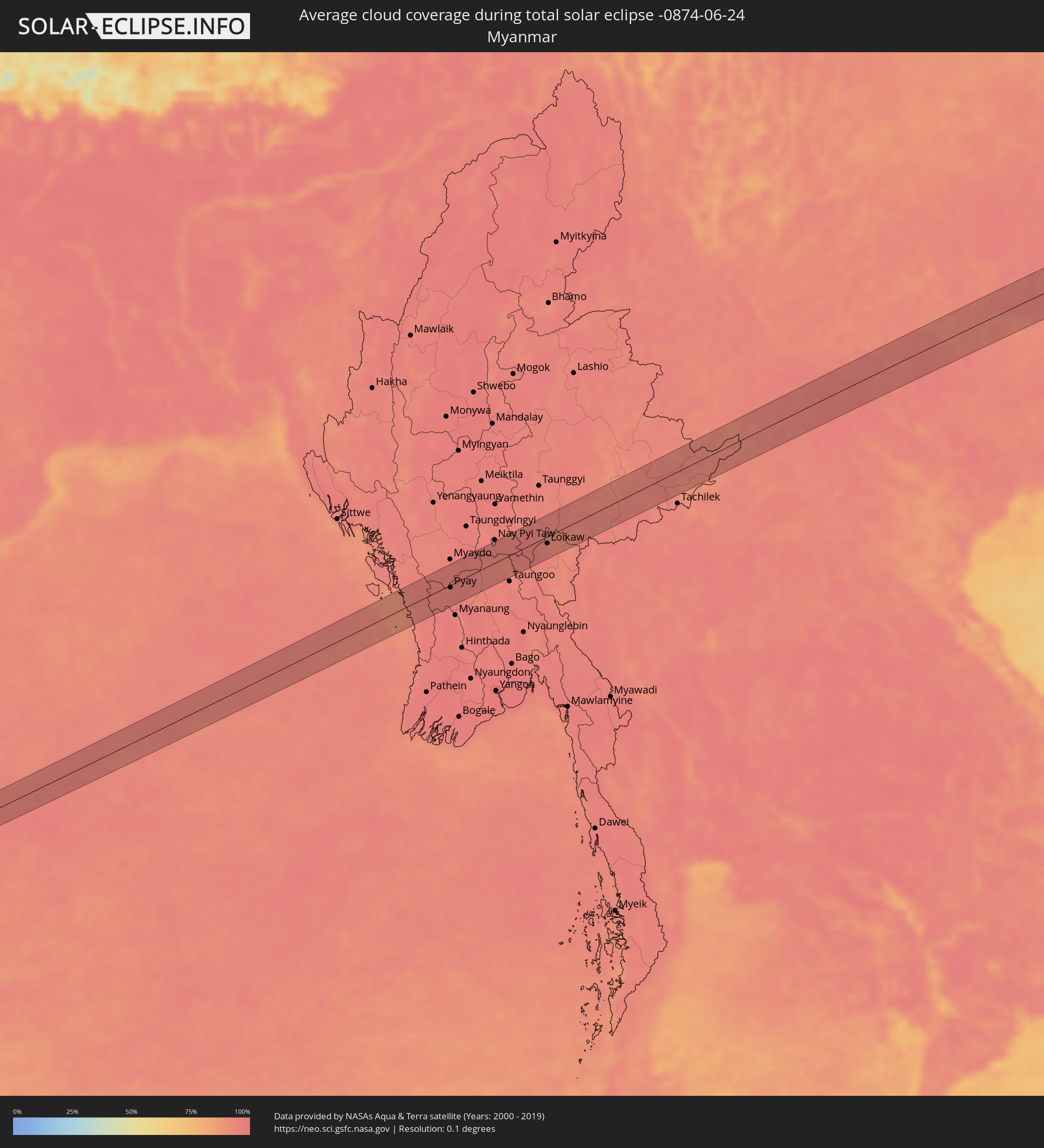 Myanmar
 Thailand
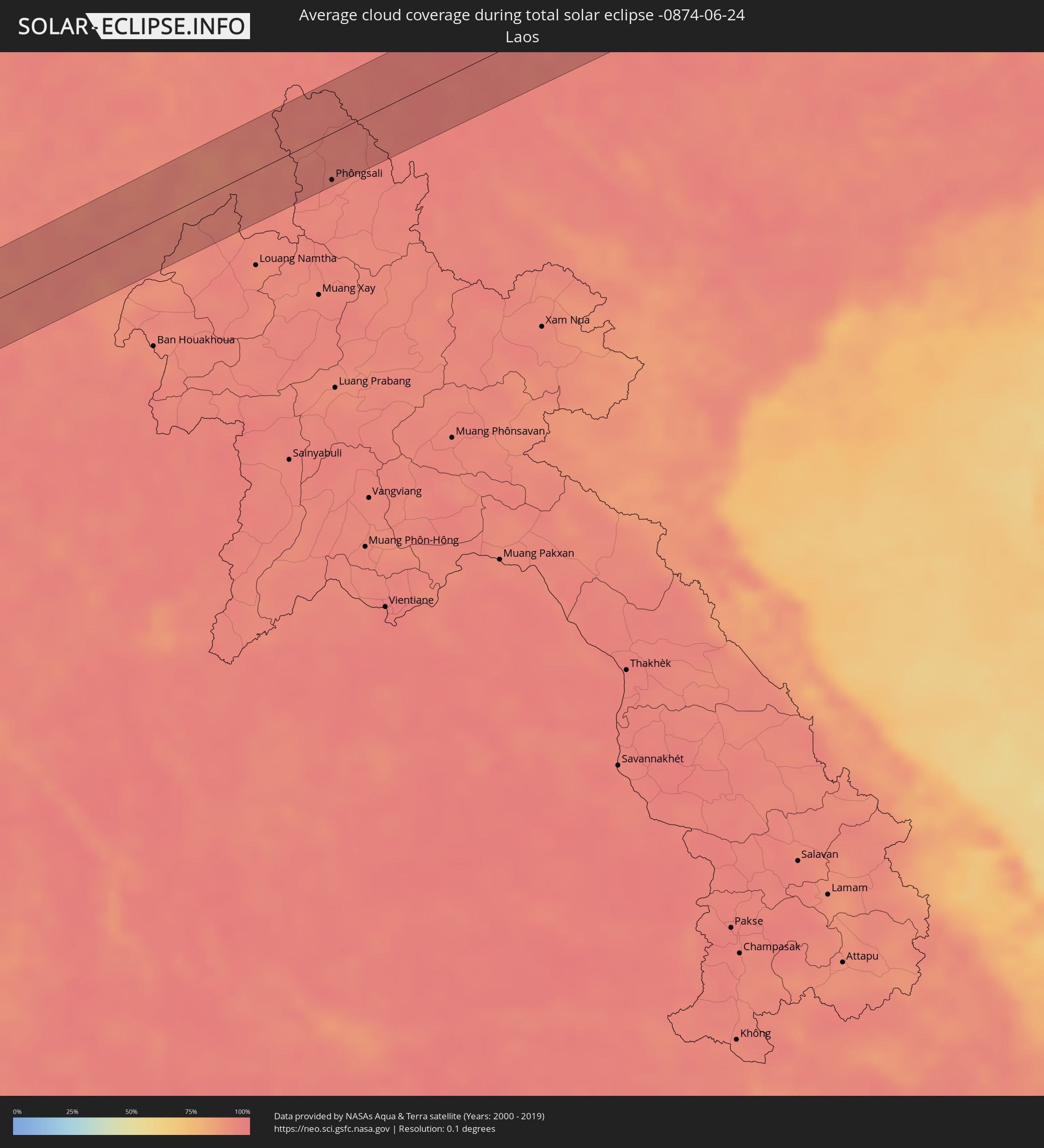 Laos
Laos
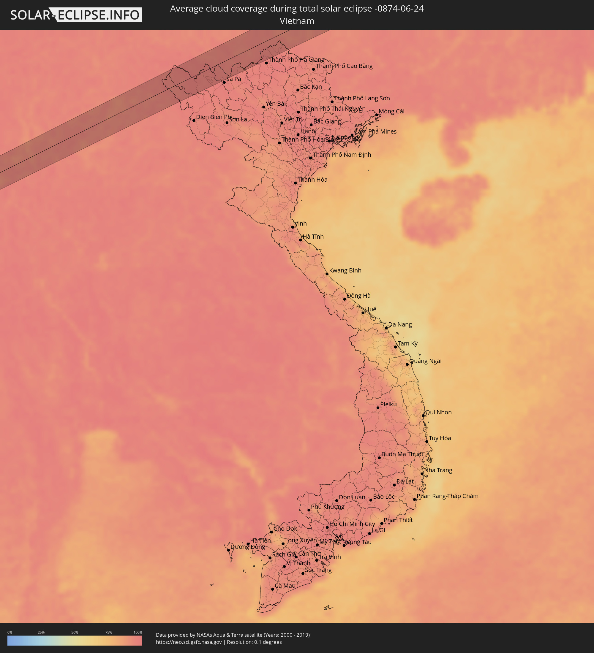 Vietnam
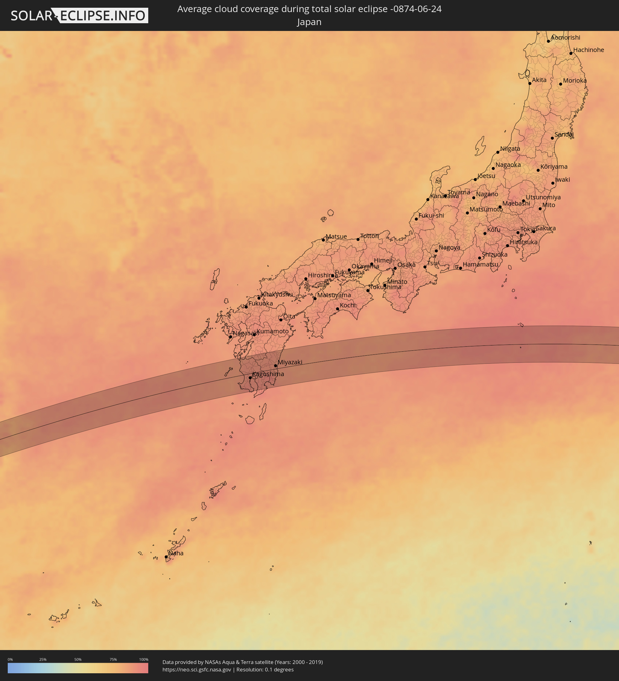 Japan
Japan
Orte im Finsternispfad
Die nachfolgene Tabelle zeigt Städte und Orte mit mehr als 5.000 Einwohnern, die sich im Finsternispfad befinden. Städte mit mehr als 100.000 Einwohnern sind dick gekennzeichnet. Mit einem Klick auf den Ort öffnet sich eine Detailkarte die die Lage des jeweiligen Ortes zusammen mit dem Verlauf der zentralen Finsternis präsentiert.
| Ort | Typ | Dauer der Verfinsterung | Ortszeit bei maximaler Verfinsterung | Entfernung zur Zentrallinie | Ø Bewölkung |
|
Kodungallūr, Kerala
|
total | - | 05:52:26 UTC+05:21 | 17 km | 90% |
|
Kizhake Chālakudi, Kerala
|
total | - | 05:52:27 UTC+05:21 | 19 km | 96% |
|
Aluva, Kerala
|
total | - | 05:52:21 UTC+05:21 | 2 km | 96% |
|
Aluva, Kerala
|
total | - | 05:52:20 UTC+05:21 | 2 km | 96% |
|
Perumpāvūr, Kerala
|
total | - | 05:52:19 UTC+05:21 | 7 km | 96% |
|
Kotamangalam, Kerala
|
total | - | 05:52:15 UTC+05:21 | 20 km | 96% |
|
Kuttampuzha, Kerala
|
total | - | 05:52:17 UTC+05:21 | 14 km | 96% |
|
Vettaikkaranpudur, Tamil Nadu
|
total | - | 05:52:28 UTC+05:21 | 19 km | 92% |
|
Anaimalai, Tamil Nadu
|
total | - | 05:52:28 UTC+05:21 | 20 km | 92% |
|
Valparai, Tamil Nadu
|
total | - | 05:52:20 UTC+05:21 | 6 km | 97% |
|
Pollachi, Tamil Nadu
|
total | - | 05:52:30 UTC+05:21 | 25 km | 92% |
|
Marayur, Kerala
|
total | - | 05:52:15 UTC+05:21 | 21 km | 89% |
|
Udumalaippettai, Tamil Nadu
|
total | - | 05:52:25 UTC+05:21 | 7 km | 88% |
|
Palani, Tamil Nadu
|
total | - | 05:52:17 UTC+05:21 | 19 km | 88% |
|
Dharapuram, Tamil Nadu
|
total | - | 05:52:26 UTC+05:21 | 9 km | 90% |
|
Ayakudi, Tamil Nadu
|
total | - | 05:52:16 UTC+05:21 | 21 km | 86% |
|
Pallappatti, Tamil Nadu
|
total | - | 05:52:21 UTC+05:21 | 8 km | 86% |
|
Kodumudi, Tamil Nadu
|
total | - | 05:52:34 UTC+05:21 | 28 km | 87% |
|
Velur, Tamil Nadu
|
total | - | 05:52:33 UTC+05:21 | 26 km | 86% |
|
Karur, Tamil Nadu
|
total | - | 05:52:27 UTC+05:21 | 7 km | 89% |
|
Nāmakkal, Tamil Nadu
|
total | - | 05:52:35 UTC+05:21 | 30 km | 87% |
|
Musiri, Tamil Nadu
|
total | - | 05:52:23 UTC+05:21 | 10 km | 88% |
|
Turaiyūr, Tamil Nadu
|
total | - | 05:52:29 UTC+05:21 | 3 km | 85% |
|
Perambalur, Tamil Nadu
|
total | - | 05:52:29 UTC+05:21 | 2 km | 85% |
|
Ariyalūr, Tamil Nadu
|
total | - | 05:52:24 UTC+05:21 | 20 km | 87% |
|
Pennādam, Tamil Nadu
|
total | - | 05:52:31 UTC+05:21 | 1 km | 86% |
|
Vriddhāchalam, Tamil Nadu
|
total | - | 05:52:35 UTC+05:21 | 7 km | 86% |
|
Jayamkondacholapuram, Tamil Nadu
|
total | - | 05:52:24 UTC+05:21 | 26 km | 83% |
|
Panruti, Tamil Nadu
|
total | - | 05:52:42 UTC+05:21 | 23 km | 84% |
|
Kurinjippādi, Tamil Nadu
|
total | - | 05:52:34 UTC+05:21 | 2 km | 83% |
|
Bhuvanagiri, Tamil Nadu
|
total | - | 05:52:29 UTC+05:21 | 15 km | 89% |
|
Chidambaram, Tamil Nadu
|
total | - | 05:52:27 UTC+05:21 | 22 km | 87% |
|
Cuddalore, Tamil Nadu
|
total | - | 05:52:39 UTC+05:21 | 10 km | 79% |
|
Puducherry, Pondicherry
|
total | - | 05:52:46 UTC+05:21 | 26 km | 83% |
|
Pyay, Bago
|
total | - | 07:03:54 UTC+06:24 | 5 km | 95% |
|
Pyinmana, Nay Pyi Taw
|
total | - | 07:05:14 UTC+06:24 | 40 km | 97% |
|
Loikaw, Kayah
|
total | - | 07:05:42 UTC+06:24 | 13 km | 93% |
|
Phôngsali, Phôngsali
|
total | - | 07:28:15 UTC+06:42 | 40 km | 95% |
|
Lai Châu, Lai Châu
|
total | - | 07:54:42 UTC+07:06 | 30 km | 96% |
|
Lào Cai, Lào Cai
|
total | - | 07:55:15 UTC+07:06 | 45 km | 95% |
|
Wenshan City, Yunnan
|
total | - | 08:49:47 UTC+08:00 | 31 km | 94% |
|
Kaihua, Yunnan
|
total | - | 08:49:49 UTC+08:00 | 30 km | 94% |
|
Mabai, Yunnan
|
total | - | 08:49:35 UTC+08:00 | 13 km | 96% |
|
Baise City, Guangxi Zhuang Autonomous Region
|
total | - | 08:52:39 UTC+08:00 | 20 km | 93% |
|
Guilin, Guangxi Zhuang Autonomous Region
|
total | - | 08:58:22 UTC+08:00 | 37 km | 95% |
|
Lengshuitan, Hunan
|
total | - | 09:01:19 UTC+08:00 | 24 km | 88% |
|
Wuxi, Hunan
|
total | - | 09:01:52 UTC+08:00 | 31 km | 89% |
|
Bojia, Hunan
|
total | - | 09:01:53 UTC+08:00 | 14 km | 88% |
|
Hongqiao, Hunan
|
total | - | 09:02:25 UTC+08:00 | 39 km | 93% |
|
Hengyang, Hunan
|
total | - | 09:03:15 UTC+08:00 | 31 km | 91% |
|
Leiyang, Hunan
|
total | - | 09:03:01 UTC+08:00 | 28 km | 88% |
|
Fenyi, Jiangxi
|
total | - | 09:07:14 UTC+08:00 | 46 km | 90% |
|
Xinyu, Jiangxi
|
total | - | 09:07:37 UTC+08:00 | 36 km | 92% |
|
Ji’an, Jiangxi
|
total | - | 09:06:54 UTC+08:00 | 37 km | 88% |
|
Jianguang, Jiangxi
|
total | - | 09:09:21 UTC+08:00 | 44 km | 90% |
|
Guixi, Jiangxi
|
total | - | 09:11:44 UTC+08:00 | 2 km | 91% |
|
Shangrao, Jiangxi
|
total | - | 09:13:08 UTC+08:00 | 6 km | 91% |
|
Quzhou, Zhejiang
|
total | - | 09:15:16 UTC+08:00 | 15 km | 91% |
|
Lanxi, Zhejiang
|
total | - | 09:16:36 UTC+08:00 | 21 km | 89% |
|
Jinhua, Zhejiang
|
total | - | 09:16:47 UTC+08:00 | 4 km | 90% |
|
Puyang, Zhejiang
|
total | - | 09:17:36 UTC+08:00 | 33 km | 89% |
|
Guli, Zhejiang
|
total | - | 09:17:14 UTC+08:00 | 32 km | 90% |
|
Yiwu, Zhejiang
|
total | - | 09:17:47 UTC+08:00 | 12 km | 87% |
|
Dongyang, Zhejiang
|
total | - | 09:18:00 UTC+08:00 | 2 km | 89% |
|
Zhuji, Zhejiang
|
total | - | 09:18:31 UTC+08:00 | 49 km | 89% |
|
Fenghua, Zhejiang
|
total | - | 09:20:35 UTC+08:00 | 6 km | 92% |
|
Ninghai, Zhejiang
|
total | - | 09:20:14 UTC+08:00 | 33 km | 90% |
|
Ningbo, Zhejiang
|
total | - | 09:21:05 UTC+08:00 | 25 km | 90% |
|
Zhaobaoshan, Zhejiang
|
total | - | 09:21:26 UTC+08:00 | 30 km | 90% |
|
Zhoushan, Zhejiang
|
total | - | 09:22:26 UTC+08:00 | 17 km | 86% |
|
Shenjiamen, Zhejiang
|
total | - | 09:22:35 UTC+08:00 | 11 km | 86% |
|
Akune, Kagoshima
|
total | - | 10:41:09 UTC+09:00 | 41 km | 88% |
|
Kushikino, Kagoshima
|
total | - | 10:41:06 UTC+09:00 | 7 km | 90% |
|
Satsumasendai, Kagoshima
|
total | - | 10:41:15 UTC+09:00 | 17 km | 90% |
|
Makurazaki, Kagoshima
|
total | - | 10:40:54 UTC+09:00 | 43 km | 90% |
|
Kaseda-shirakame, Kagoshima
|
total | - | 10:41:00 UTC+09:00 | 27 km | 92% |
|
Izumi, Kagoshima
|
total | - | 10:41:35 UTC+09:00 | 45 km | 90% |
|
Ijūin, Kagoshima
|
total | - | 10:41:20 UTC+09:00 | 6 km | 91% |
|
Kagoshima, Kagoshima
|
total | - | 10:41:39 UTC+09:00 | 15 km | 91% |
|
Ōkuchi-shinohara, Kagoshima
|
total | - | 10:42:10 UTC+09:00 | 39 km | 90% |
|
Ibusuki, Kagoshima
|
total | - | 10:41:39 UTC+09:00 | 53 km | 90% |
|
Kajiki, Kagoshima
|
total | - | 10:42:02 UTC+09:00 | 2 km | 91% |
|
Tarumizu, Kagoshima
|
total | - | 10:41:57 UTC+09:00 | 26 km | 91% |
|
Hamanoichi, Kagoshima
|
total | - | 10:42:11 UTC+09:00 | 1 km | 91% |
|
Hitoyoshi, Kumamoto
|
total | - | 10:42:34 UTC+09:00 | 53 km | 89% |
|
Kokubu-matsuki, Kagoshima
|
total | - | 10:42:16 UTC+09:00 | 0 km | 91% |
|
Kanoya, Kagoshima
|
total | - | 10:42:14 UTC+09:00 | 40 km | 93% |
|
Kobayashi, Miyazaki
|
total | - | 10:42:57 UTC+09:00 | 23 km | 90% |
|
Sueyoshichō-ninokata, Kagoshima
|
total | - | 10:42:48 UTC+09:00 | 14 km | 93% |
|
Miyakonojō, Miyazaki
|
total | - | 10:42:58 UTC+09:00 | 5 km | 94% |
|
Shibushi, Kagoshima
|
total | - | 10:42:53 UTC+09:00 | 35 km | 91% |
|
Kushima, Miyazaki
|
total | - | 10:43:13 UTC+09:00 | 35 km | 92% |
|
Nichinan, Miyazaki
|
total | - | 10:43:36 UTC+09:00 | 25 km | 90% |
|
Tsuma, Miyazaki
|
total | - | 10:44:00 UTC+09:00 | 29 km | 88% |
|
Miyazaki, Miyazaki
|
total | - | 10:43:55 UTC+09:00 | 9 km | 89% |
|
Takanabe, Miyazaki
|
total | - | 10:44:15 UTC+09:00 | 31 km | 88% |