Totale Sonnenfinsternis vom 02.06.-0929
| Wochentag: | Mittwoch |
| Maximale Dauer der Verfinsterung: | 04m58s |
| Maximale Breite des Finsternispfades: | 332 km |
| Saroszyklus: | 32 |
| Bedeckungsgrad: | 100% |
| Magnitude: | 1.076 |
| Gamma: | 0.6682 |
Wo kann man die Sonnenfinsternis vom 02.06.-0929 sehen?
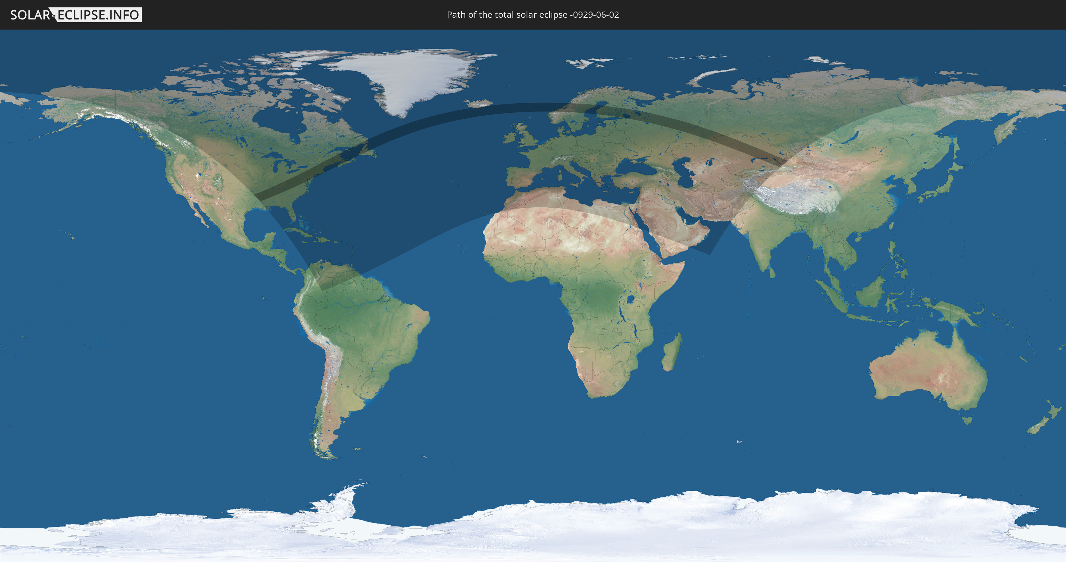
Die Sonnenfinsternis am 02.06.-0929 kann man in 120 Ländern als partielle Sonnenfinsternis beobachten.
Der Finsternispfad verläuft durch 10 Länder. Nur in diesen Ländern ist sie als totale Sonnenfinsternis zu sehen.
In den folgenden Ländern ist die Sonnenfinsternis total zu sehen
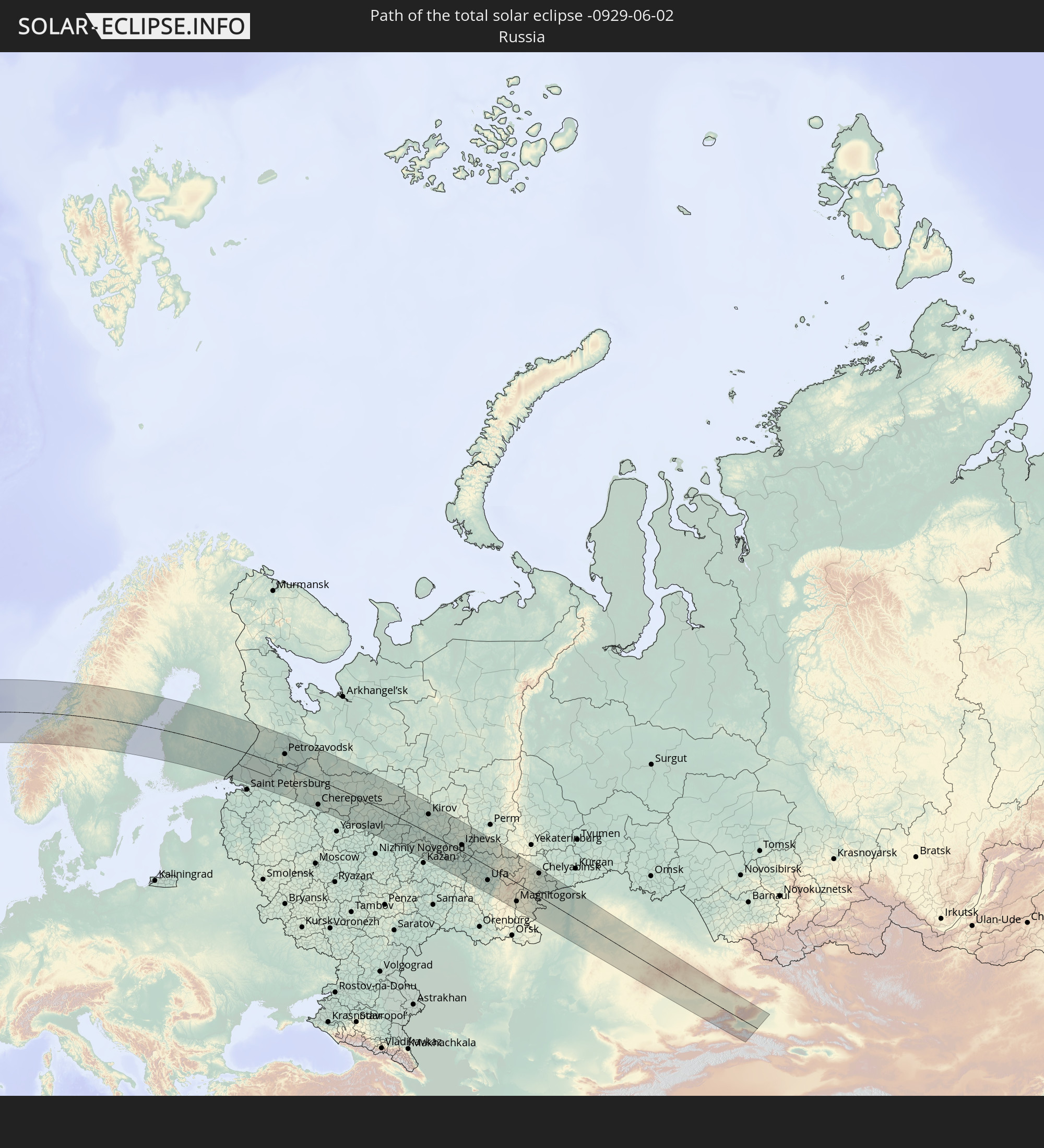 Russland
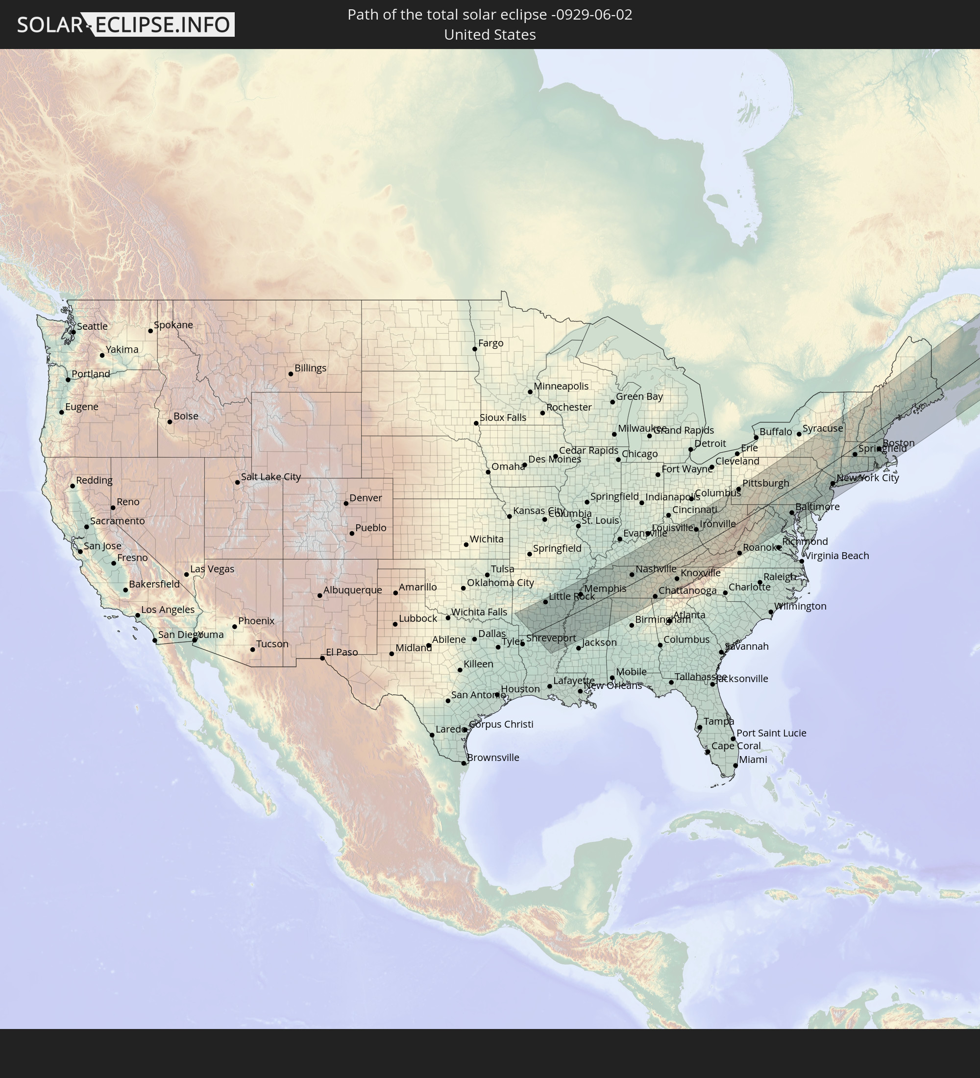 Vereinigte Staaten
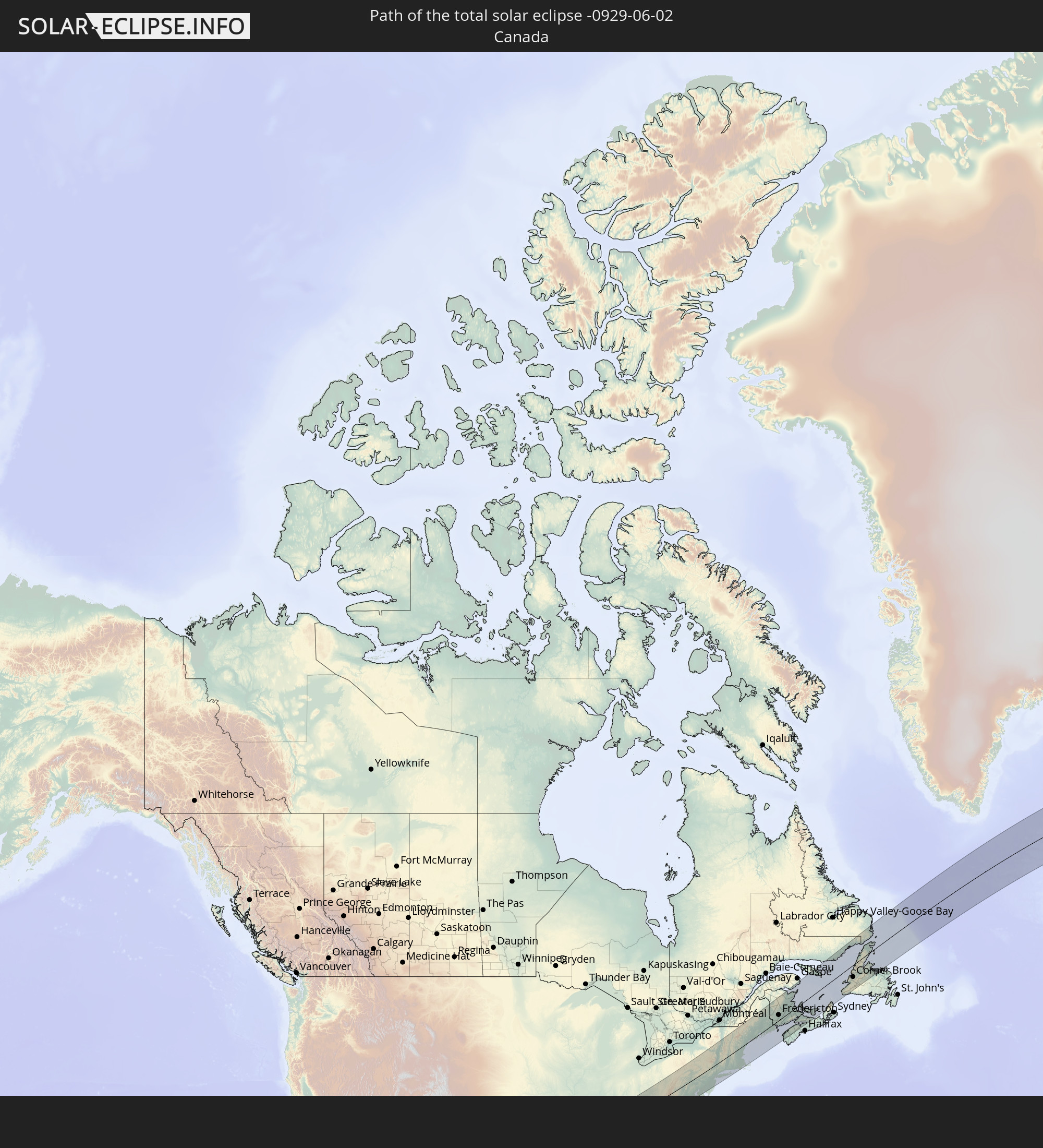 Kanada
 Island
 Färöer
 Norwegen
 Schweden
 Finnland
 Kasachstan
 Volksrepublik China
In den folgenden Ländern ist die Sonnenfinsternis partiell zu sehen
 Russland
 Vereinigte Staaten
 United States Minor Outlying Islands
 Kanada
 Grönland
 Kuba
Kuba
 Kolumbien
 Kaimaninseln
 Bahamas
 Jamaika
 Haiti
Haiti
 Venezuela
 Turks- und Caicosinseln
 Dominikanische Republik
 Aruba
Aruba
 Puerto Rico
 Amerikanische Jungferninseln
 Bermuda
 Britische Jungferninseln
 Anguilla
 Saint-Martin
 Saint-Barthélemy
 St. Kitts und Nevis
 Antigua und Barbuda
 Montserrat
 Trinidad und Tobago
 Guadeloupe
 Grenada
 Dominica
 St. Vincent und die Grenadinen
 Guyana
 Martinique
 St. Lucia
 Barbados
 Saint-Pierre und Miquelon
 Portugal
 Island
 Spanien
 Marokko
 Irland
 Spitzbergen
 Algerien
 Vereinigtes Königreich
 Färöer
 Gibraltar
 Frankreich
 Isle of Man
 Guernsey
 Jersey
 Andorra
 Belgien
 Niederlande
 Norwegen
 Luxemburg
 Deutschland
 Schweiz
 Italien
 Monaco
 Tunesien
 Dänemark
 Libyen
 Liechtenstein
 Österreich
 Schweden
 Tschechien
 San Marino
 Vatikanstadt
 Slowenien
 Kroatien
 Polen
Polen
 Malta
Malta
 Bosnien und Herzegowina
 Ungarn
 Slowakei
 Montenegro
 Serbien
 Albanien
 Åland Islands
 Griechenland
 Rumänien
 Mazedonien
 Finnland
 Litauen
 Lettland
 Estland
 Sudan
Sudan
 Ukraine
 Bulgarien
 Weißrussland
 Ägypten
 Türkei
 Moldawien
 Republik Zypern
 Staat Palästina
 Israel
 Saudi-Arabien
 Jordanien
 Libanon
 Syrien
 Irak
Irak
 Georgien
 Jemen
Jemen
 Armenien
 Iran
Iran
 Aserbaidschan
 Kasachstan
 Kuwait
 Bahrain
 Katar
Katar
 Vereinigte Arabische Emirate
 Oman
Oman
 Turkmenistan
 Usbekistan
 Afghanistan
 Pakistan
 Tadschikistan
 Indien
 Kirgisistan
 Volksrepublik China
 Mongolei
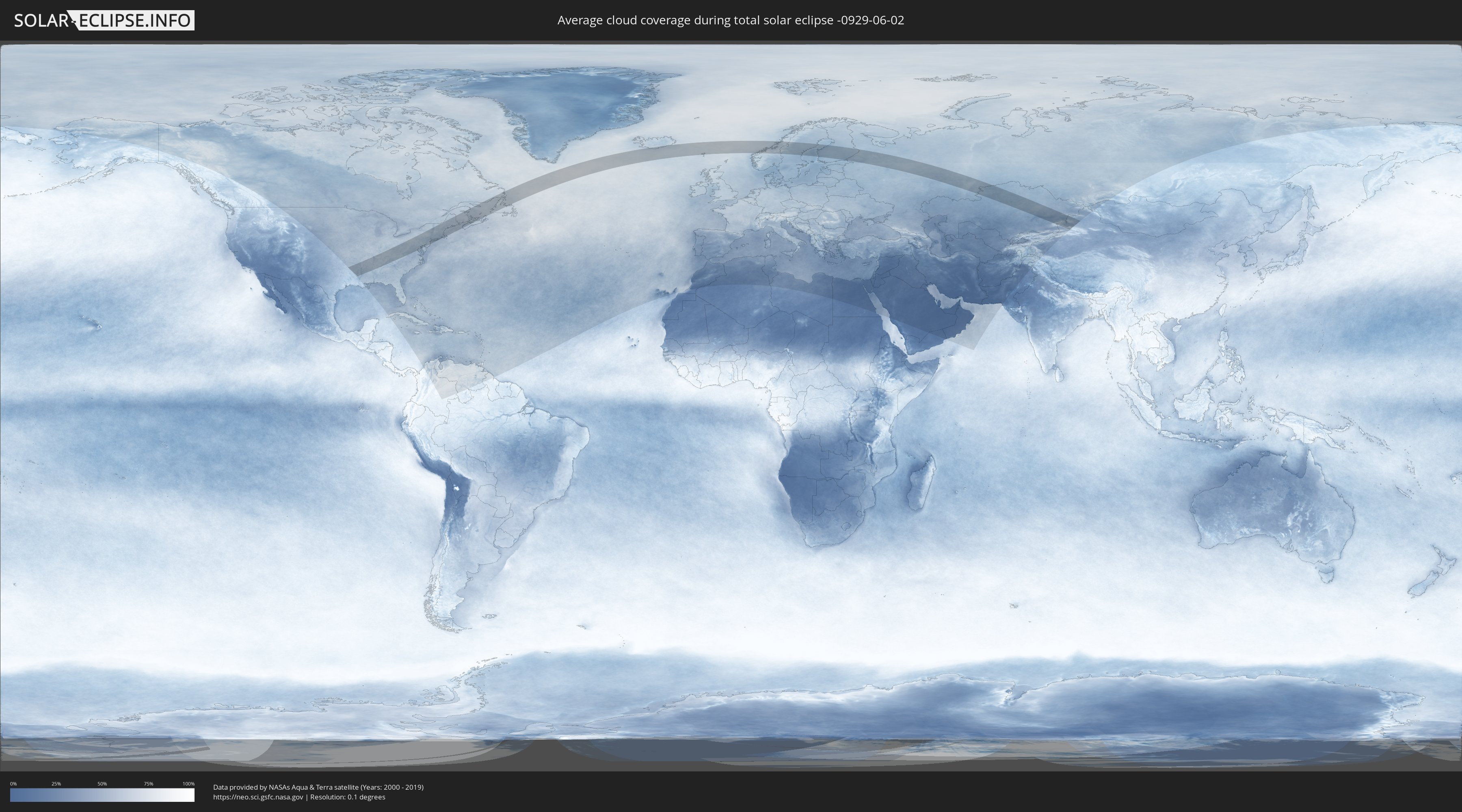
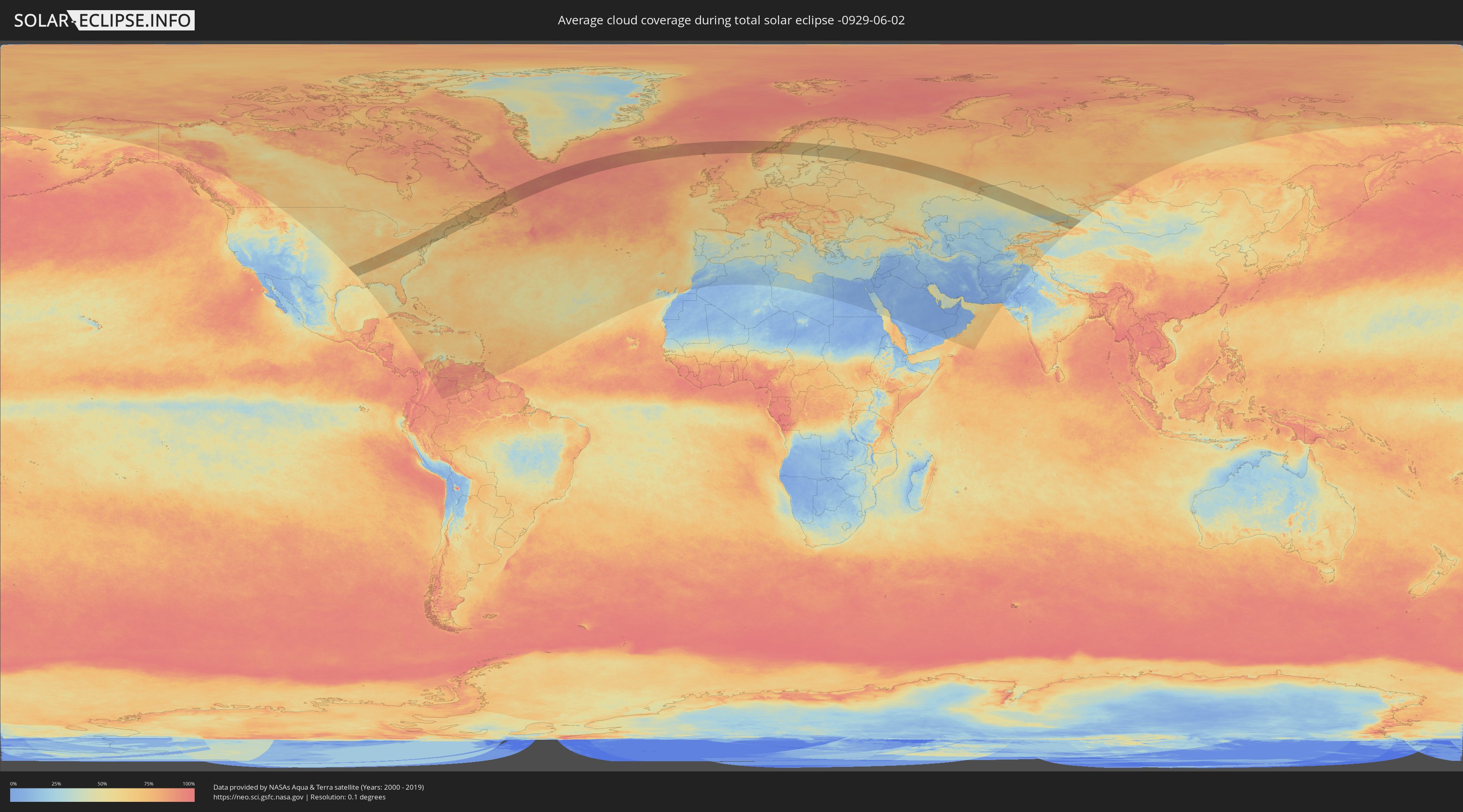
Wie wird das Wetter während der totalen Sonnenfinsternis am 02.06.-0929?
Wo ist der beste Ort, um die totale Sonnenfinsternis vom 02.06.-0929 zu beobachten?
Die folgenden Karten zeigen die durchschnittliche Bewölkung für den Tag, an dem die totale Sonnenfinsternis
stattfindet. Mit Hilfe der Karten lässt sich der Ort entlang des Finsternispfades eingrenzen,
der die besten Aussichen auf einen klaren wolkenfreien Himmel bietet.
Trotzdem muss man immer lokale Gegenenheiten beachten und sollte sich genau über das Wetter an seinem
gewählten Beobachtungsort informieren.
Die Daten stammen von den beiden NASA-Satelliten
AQUA und TERRA
und wurden über einen Zeitraum von 19 Jahren (2000 - 2019) gemittelt.
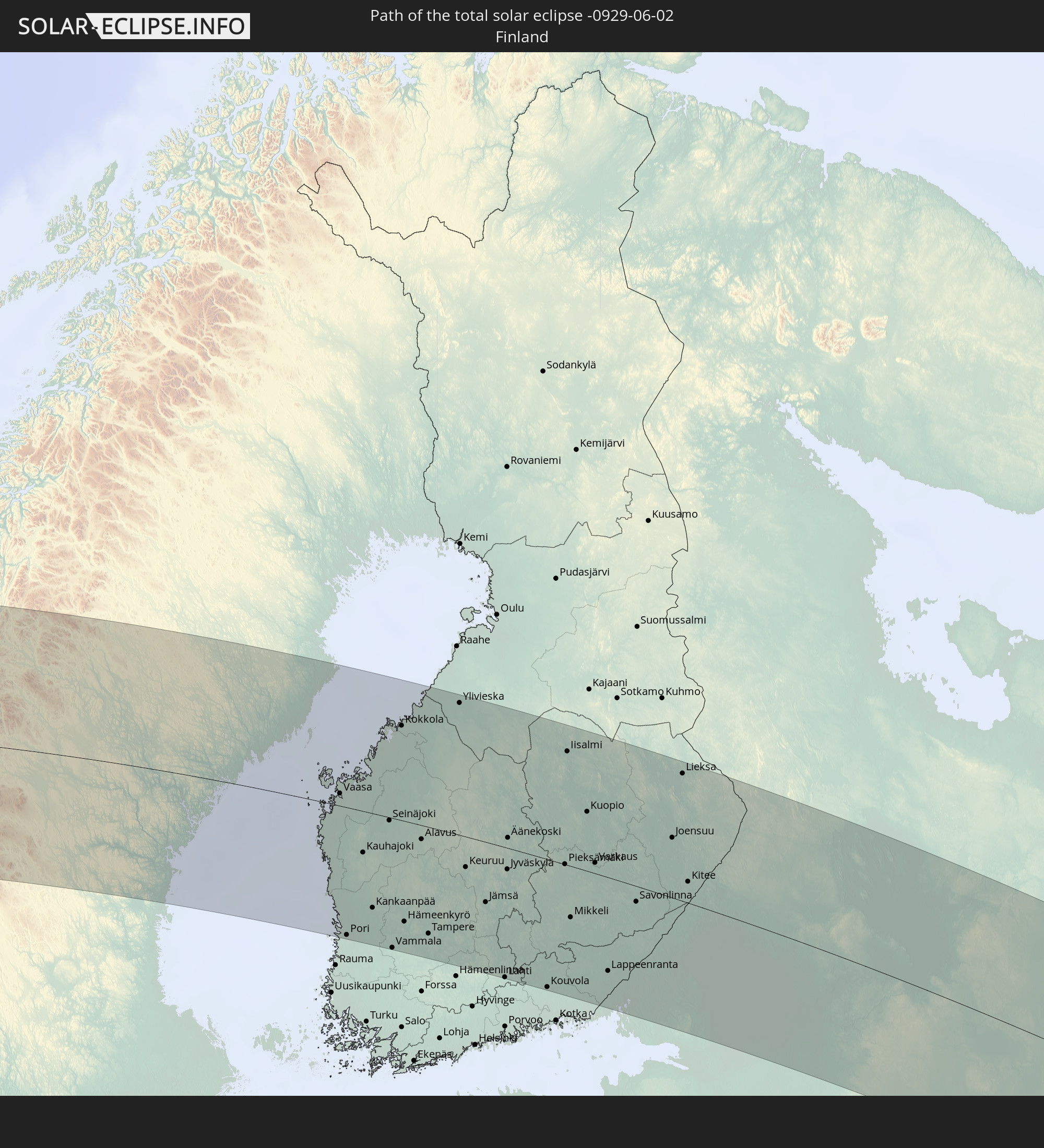
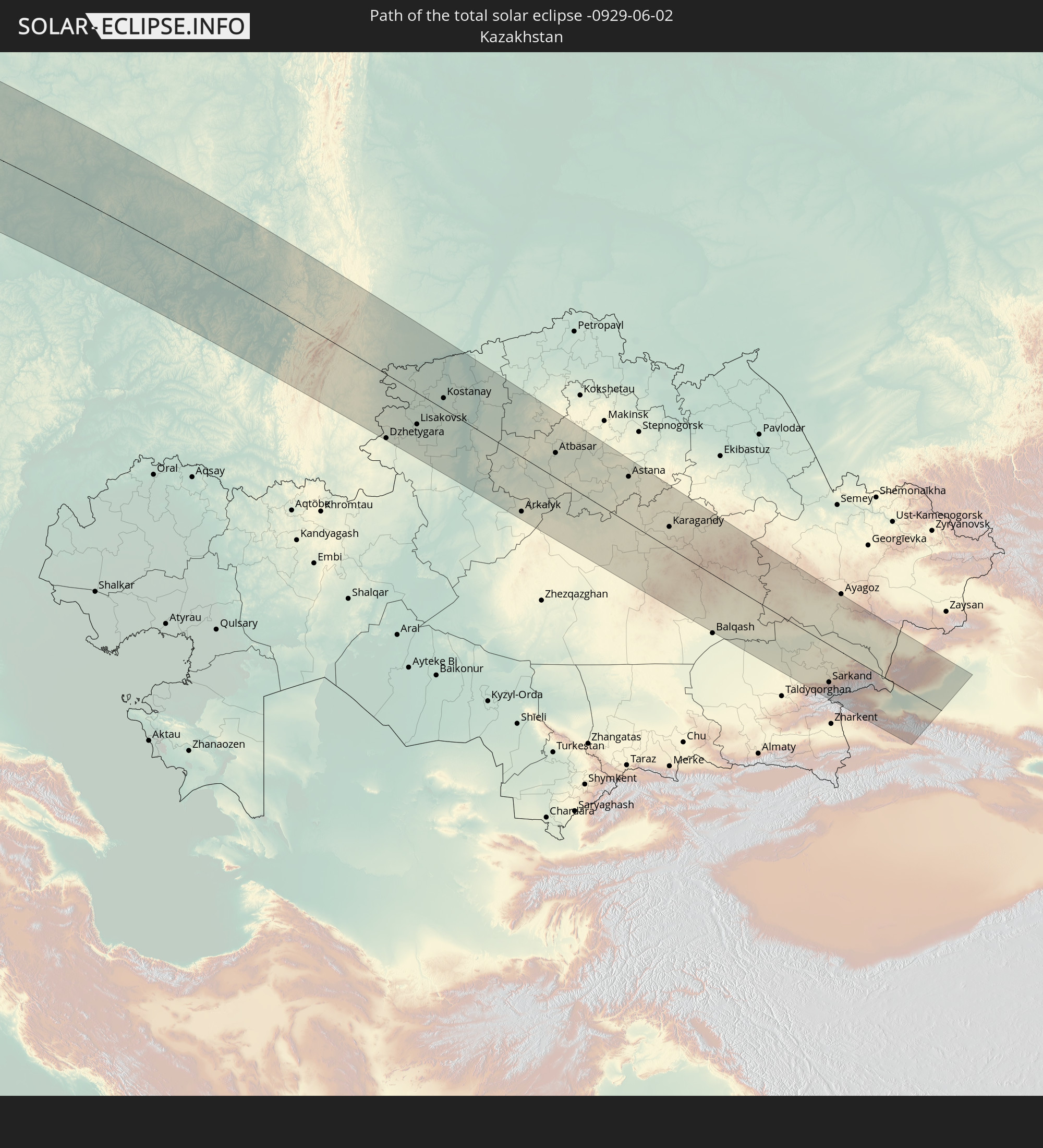
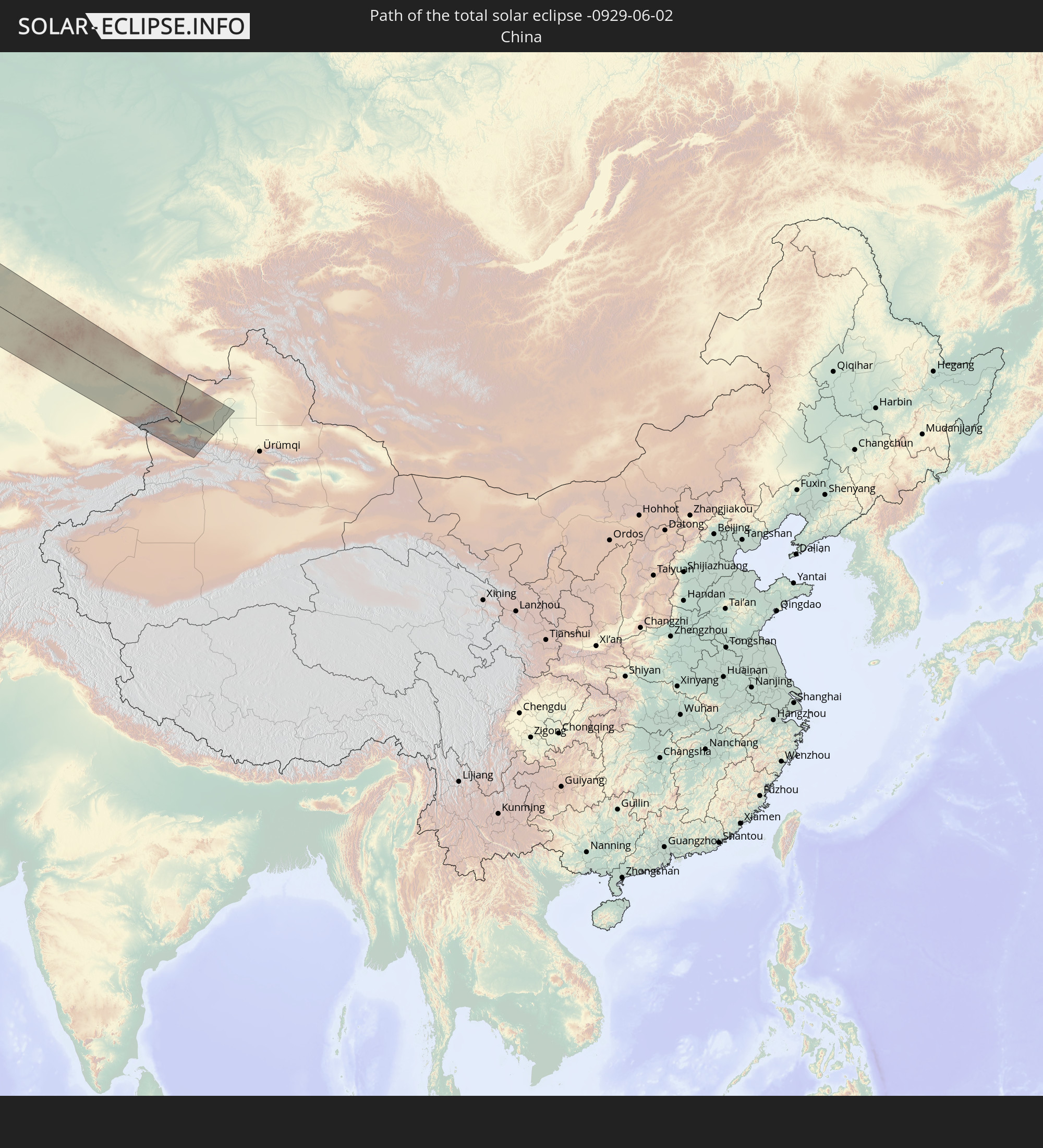
Detaillierte Länderkarten
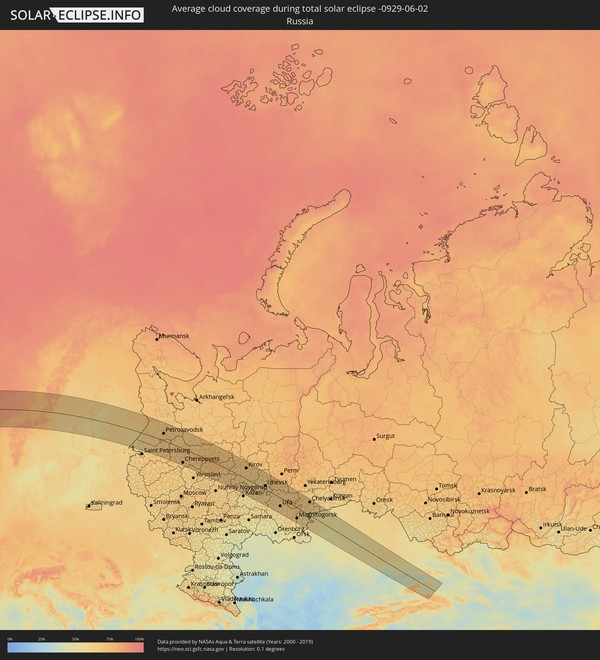 Russland
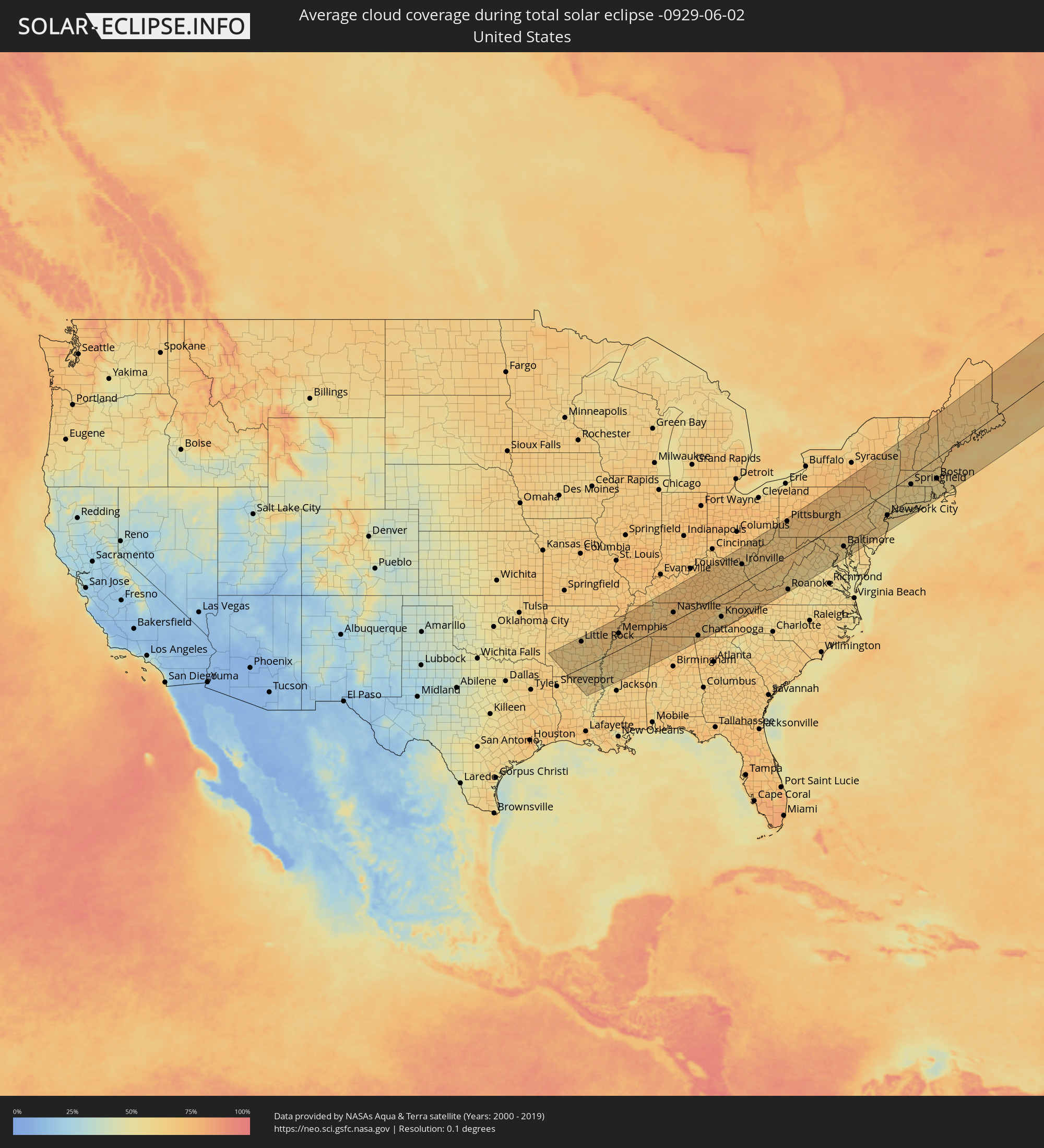 Vereinigte Staaten
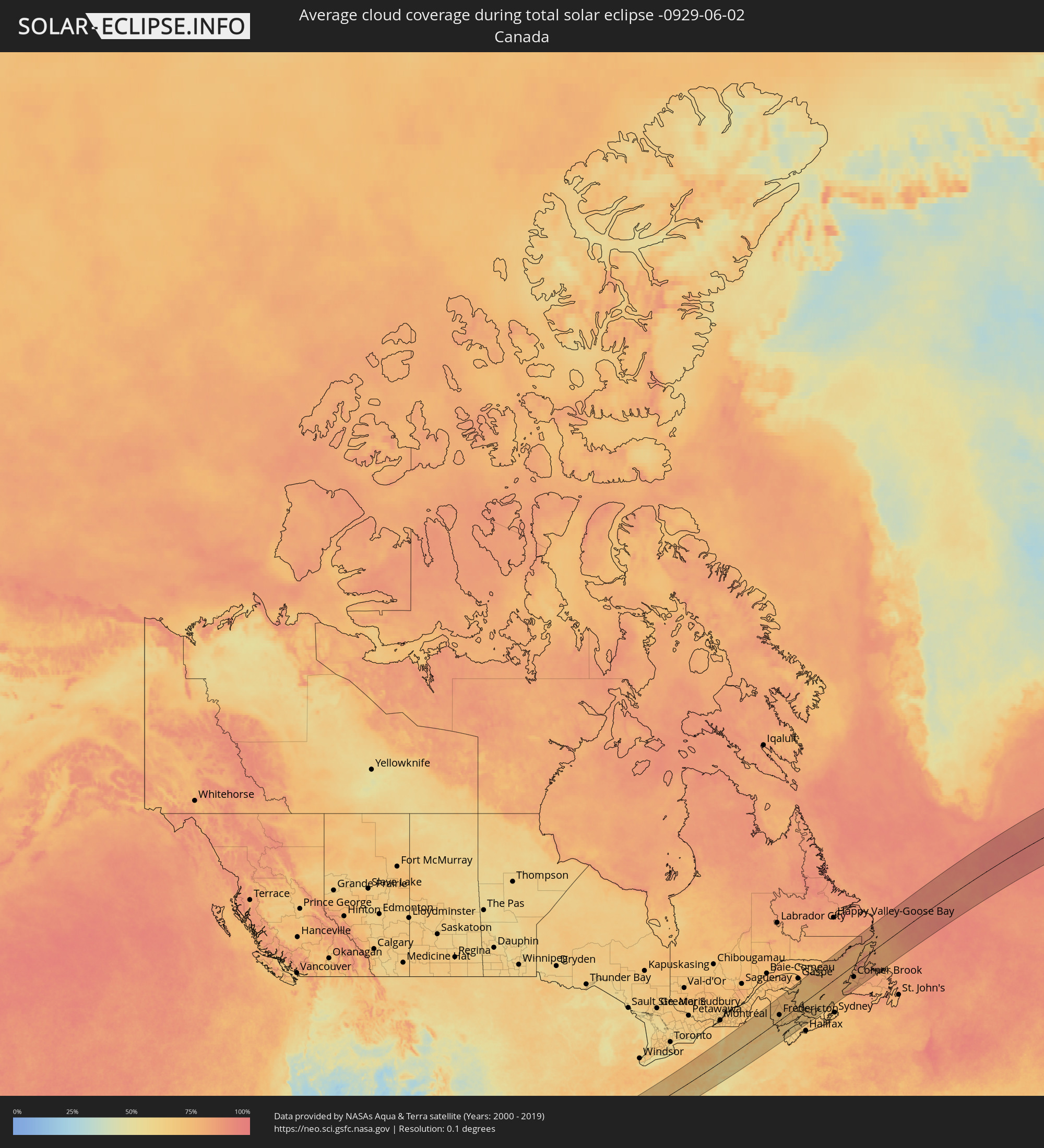 Kanada
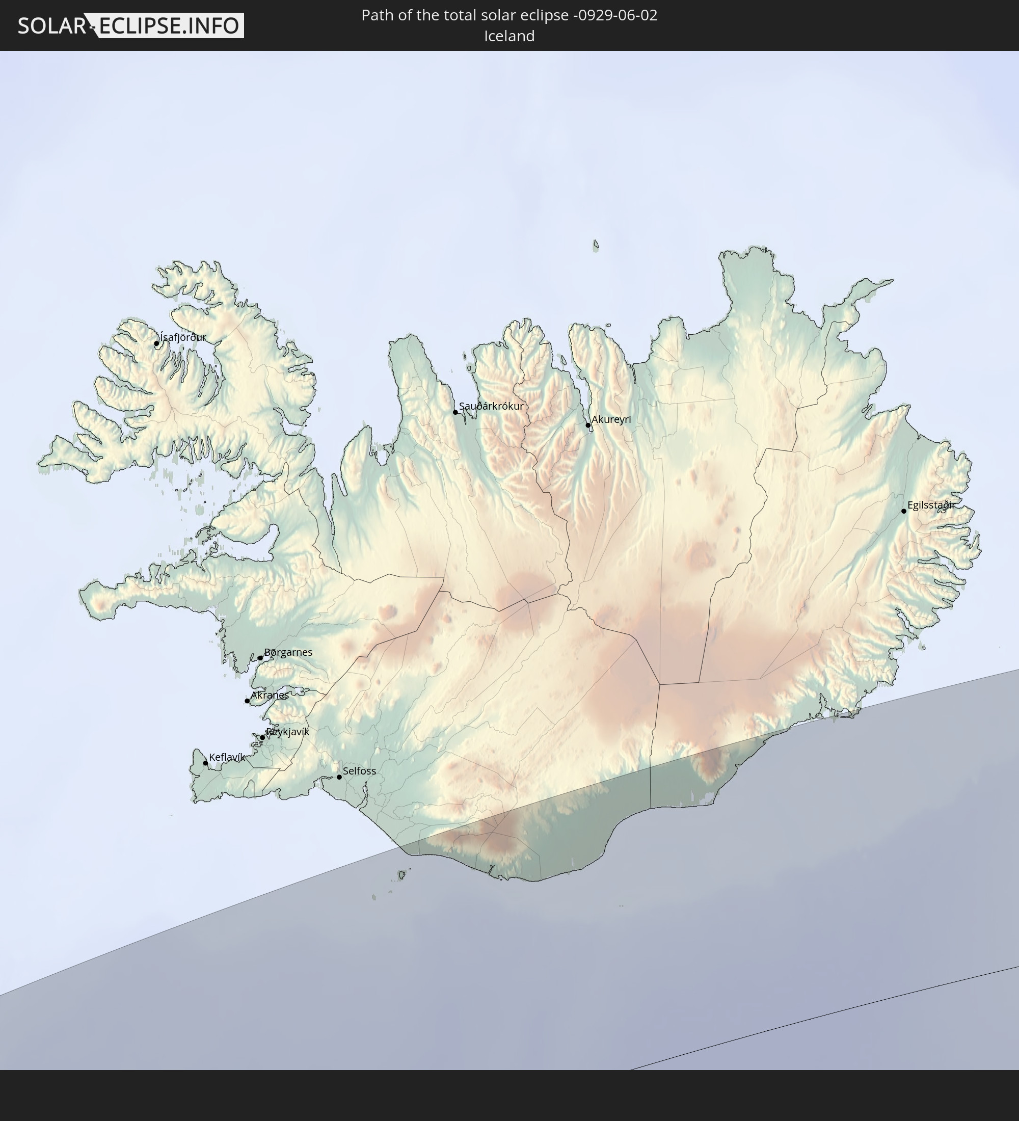
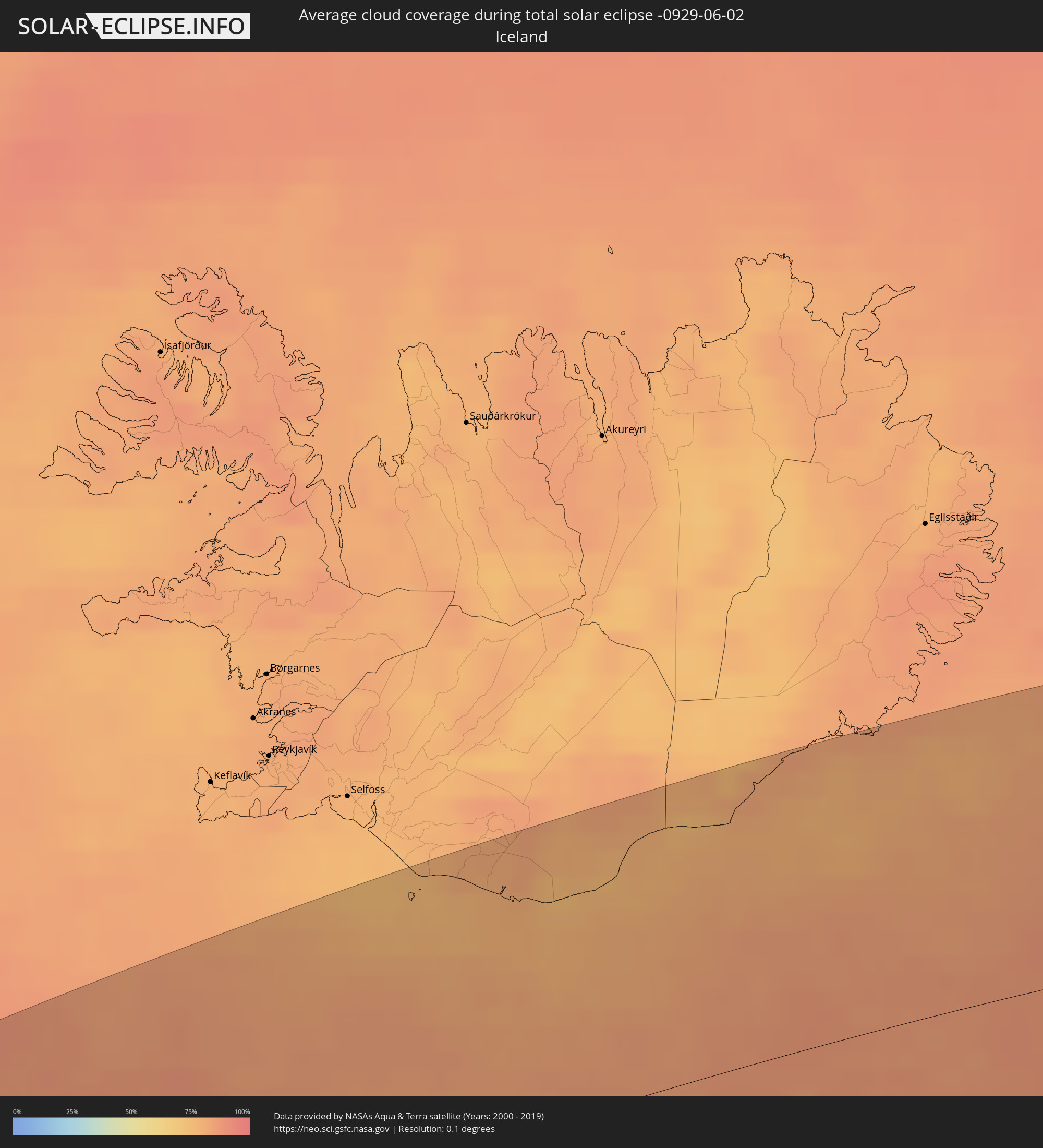 Island
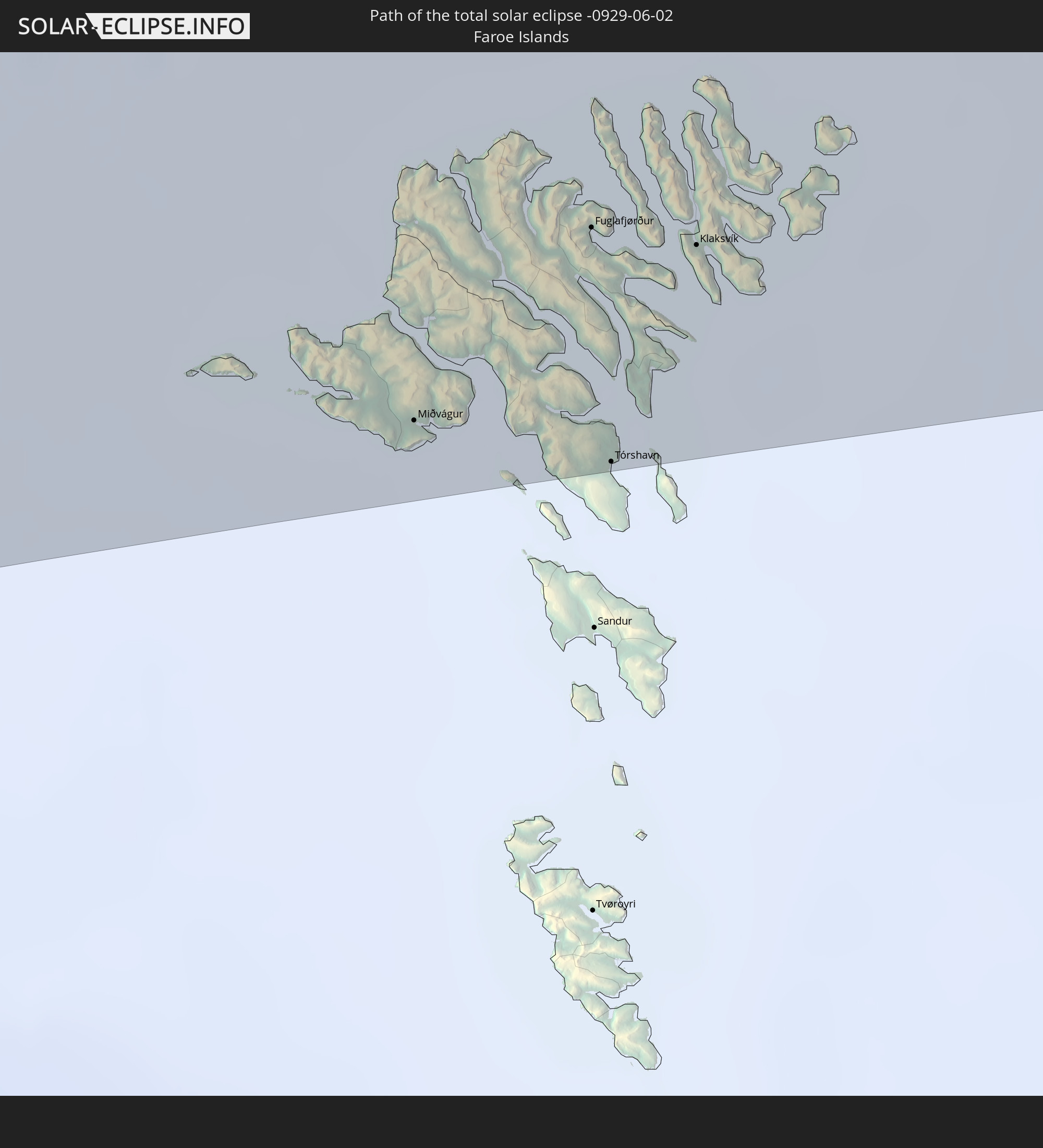
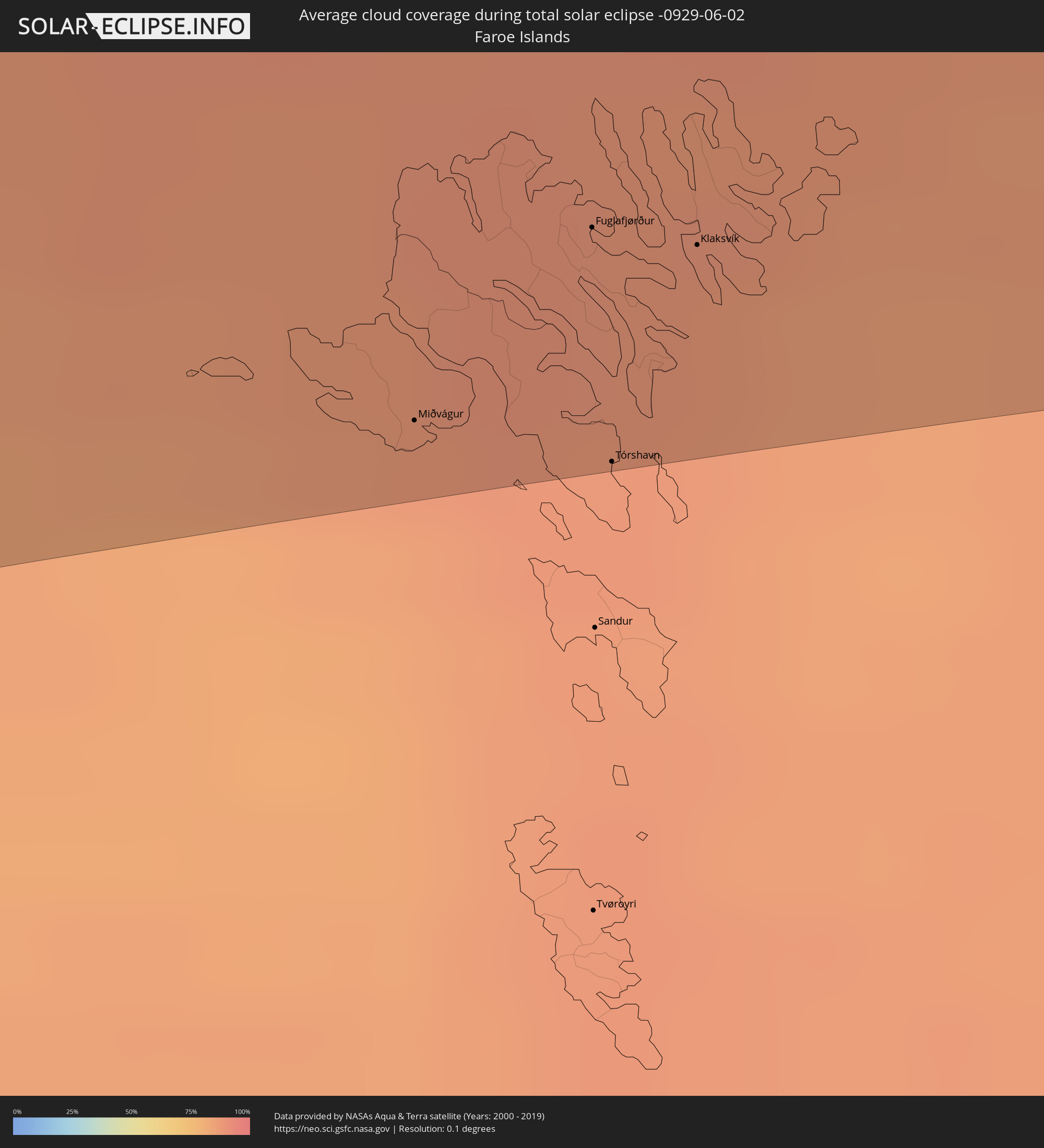 Färöer
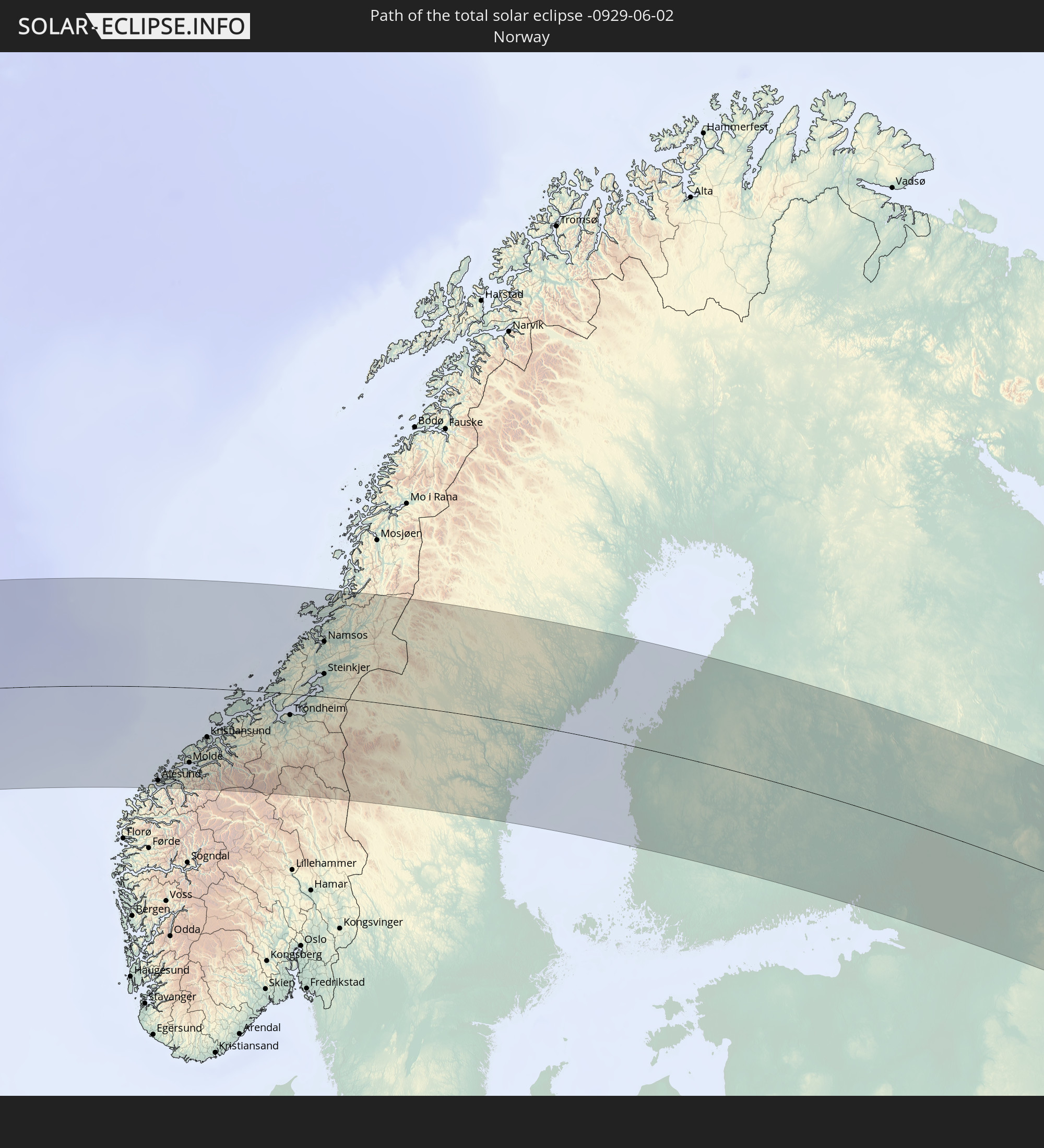
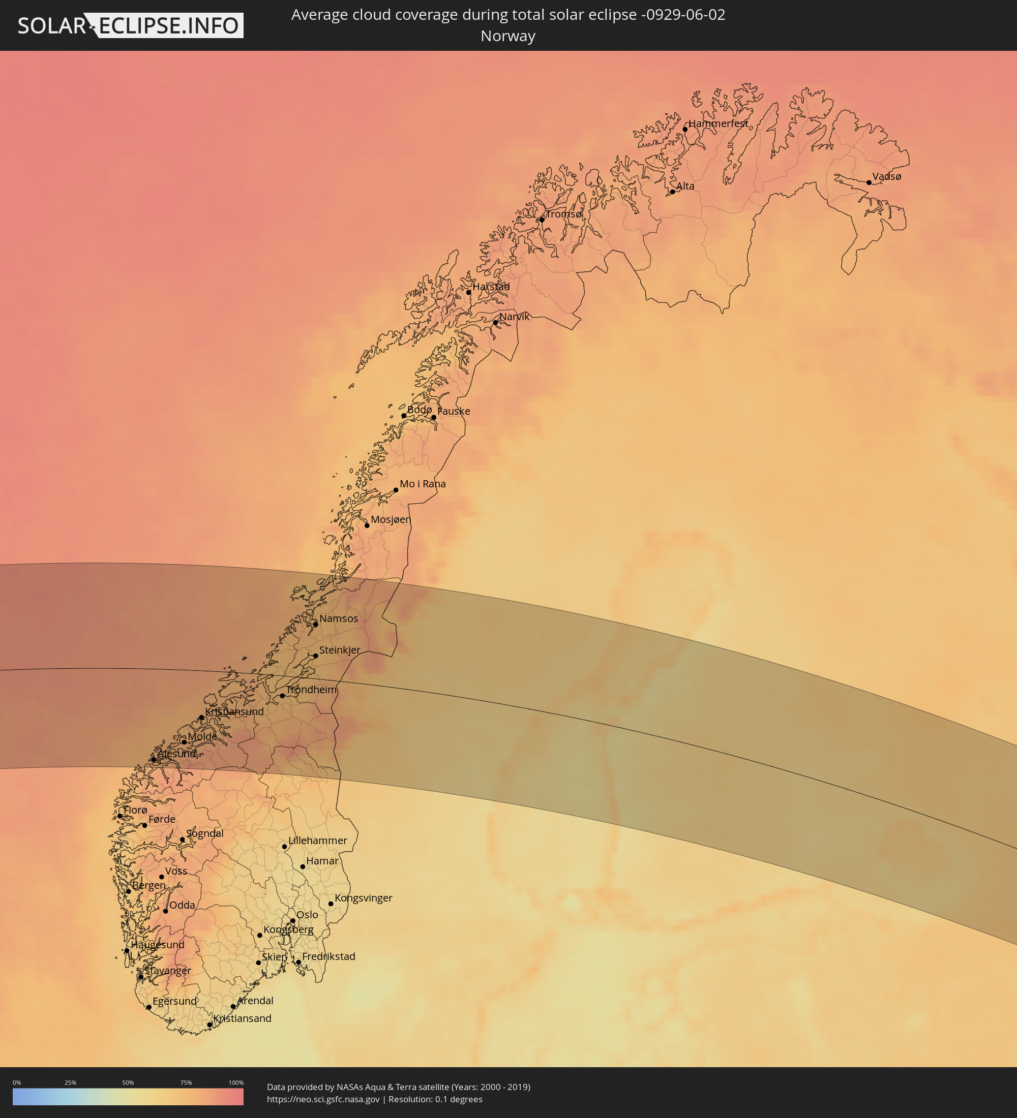 Norwegen
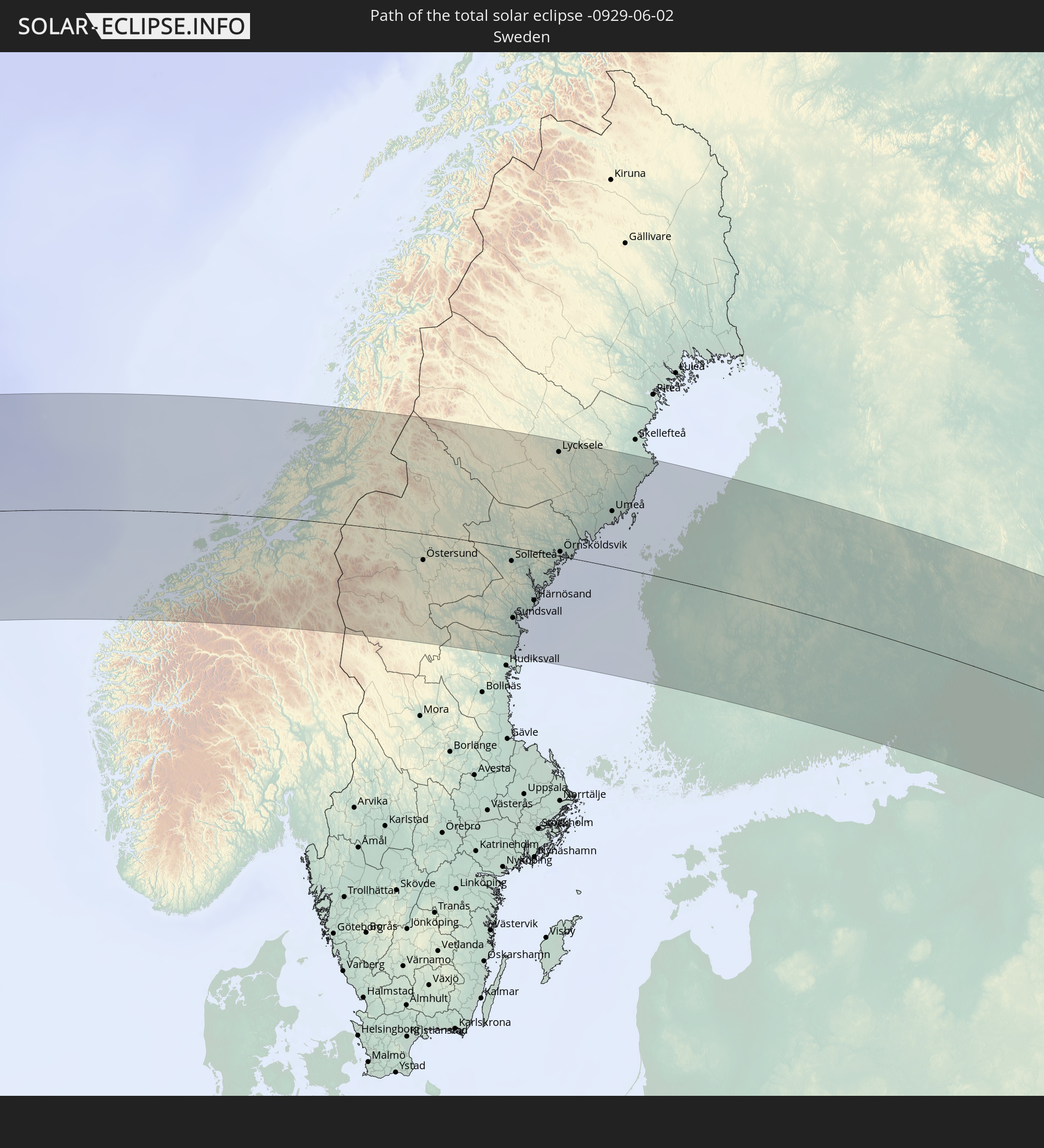
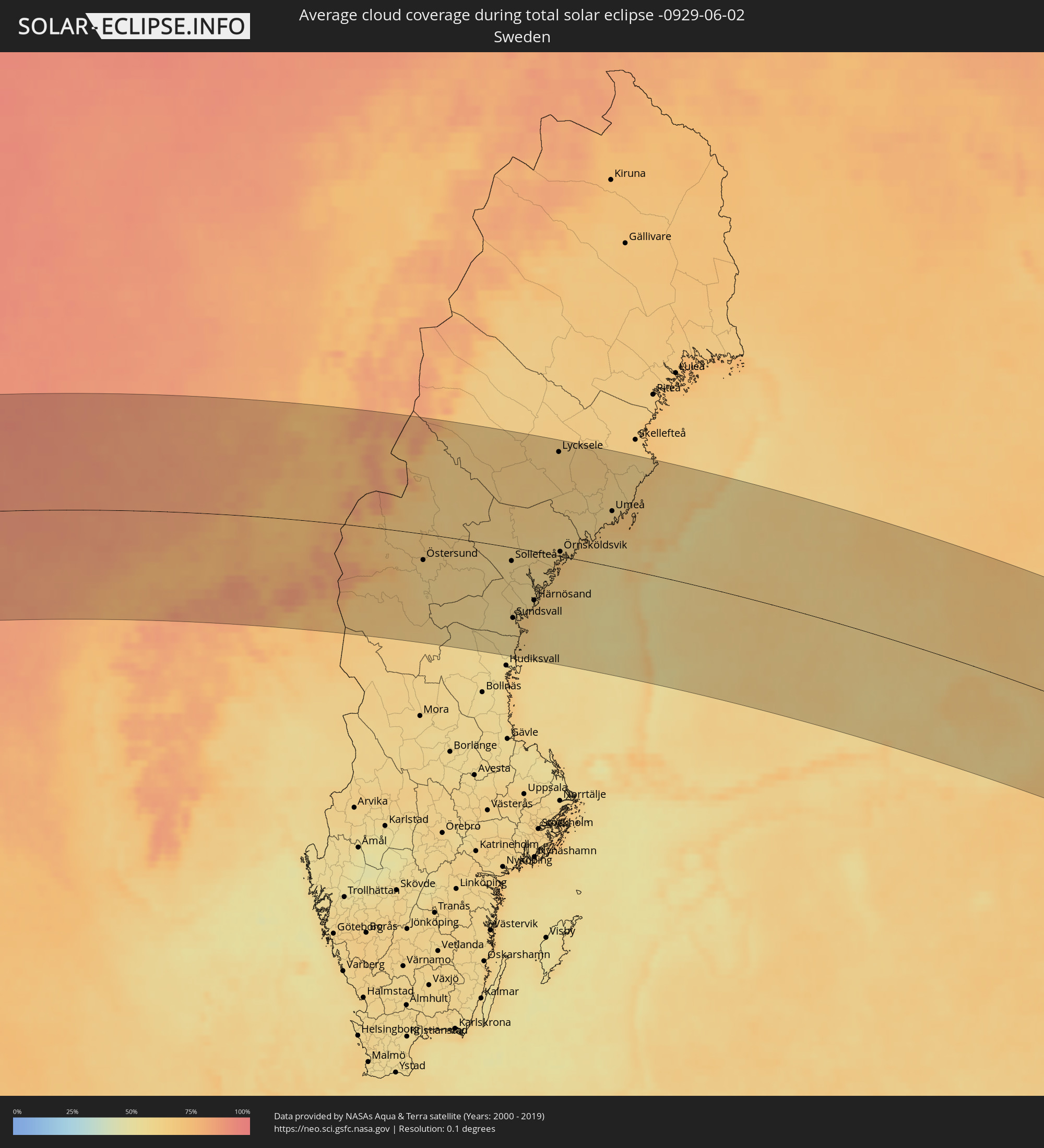 Schweden
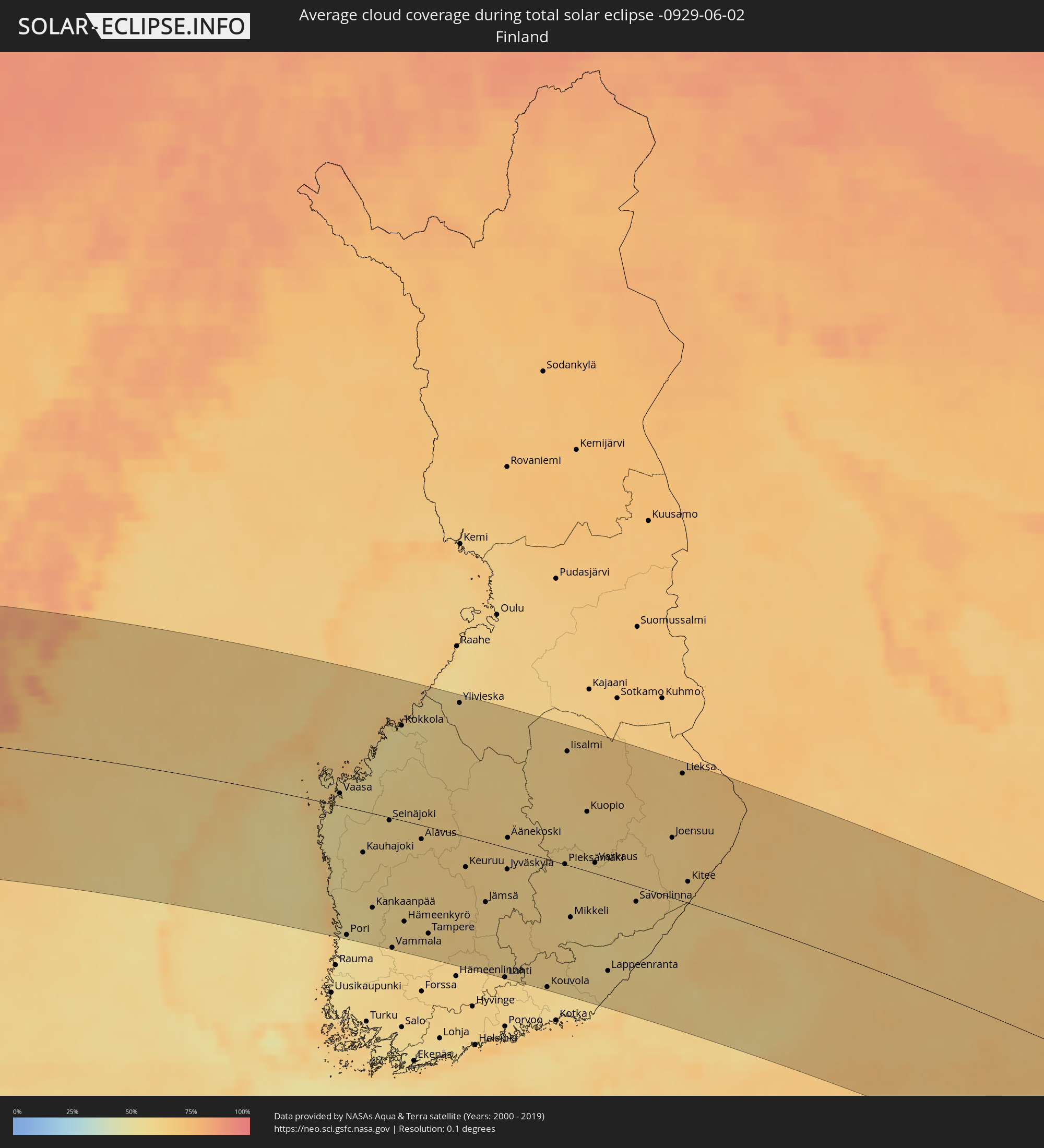 Finnland
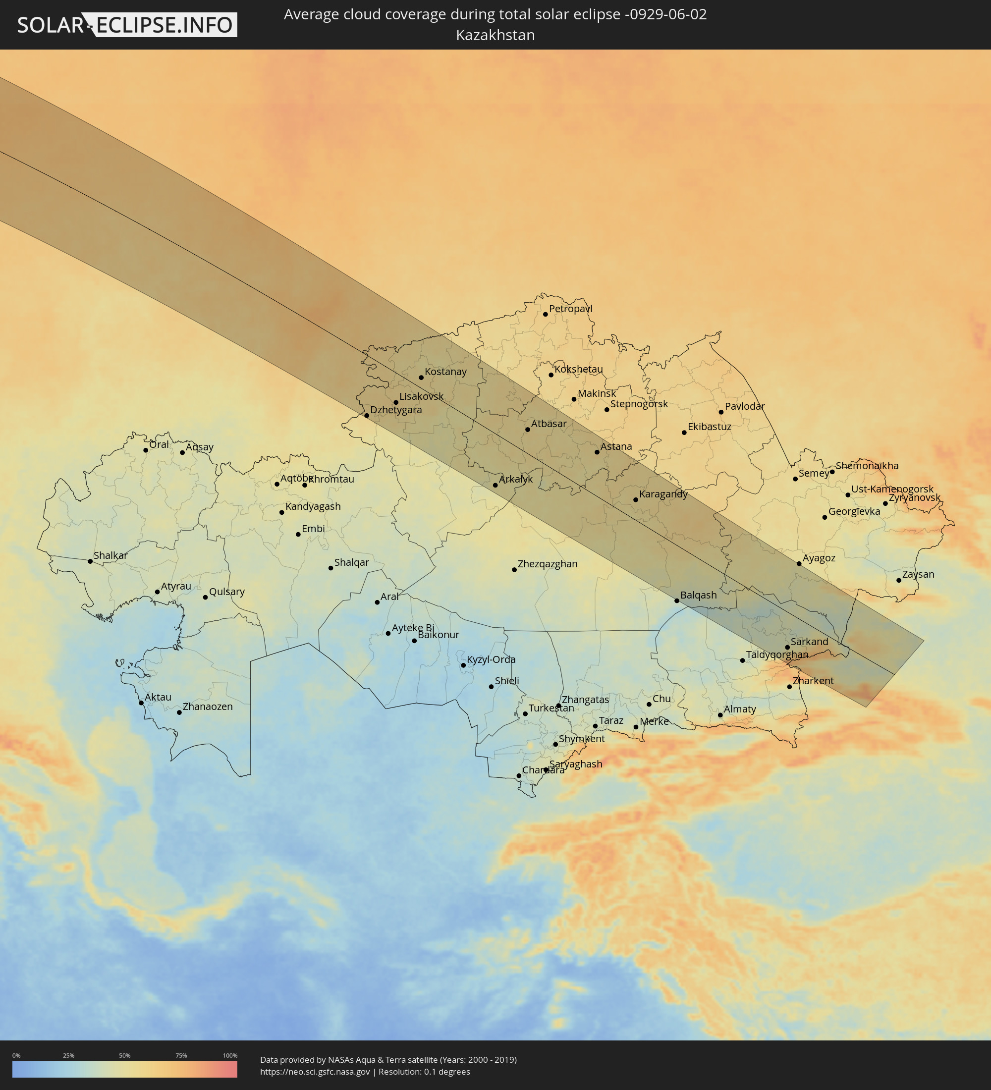 Kasachstan
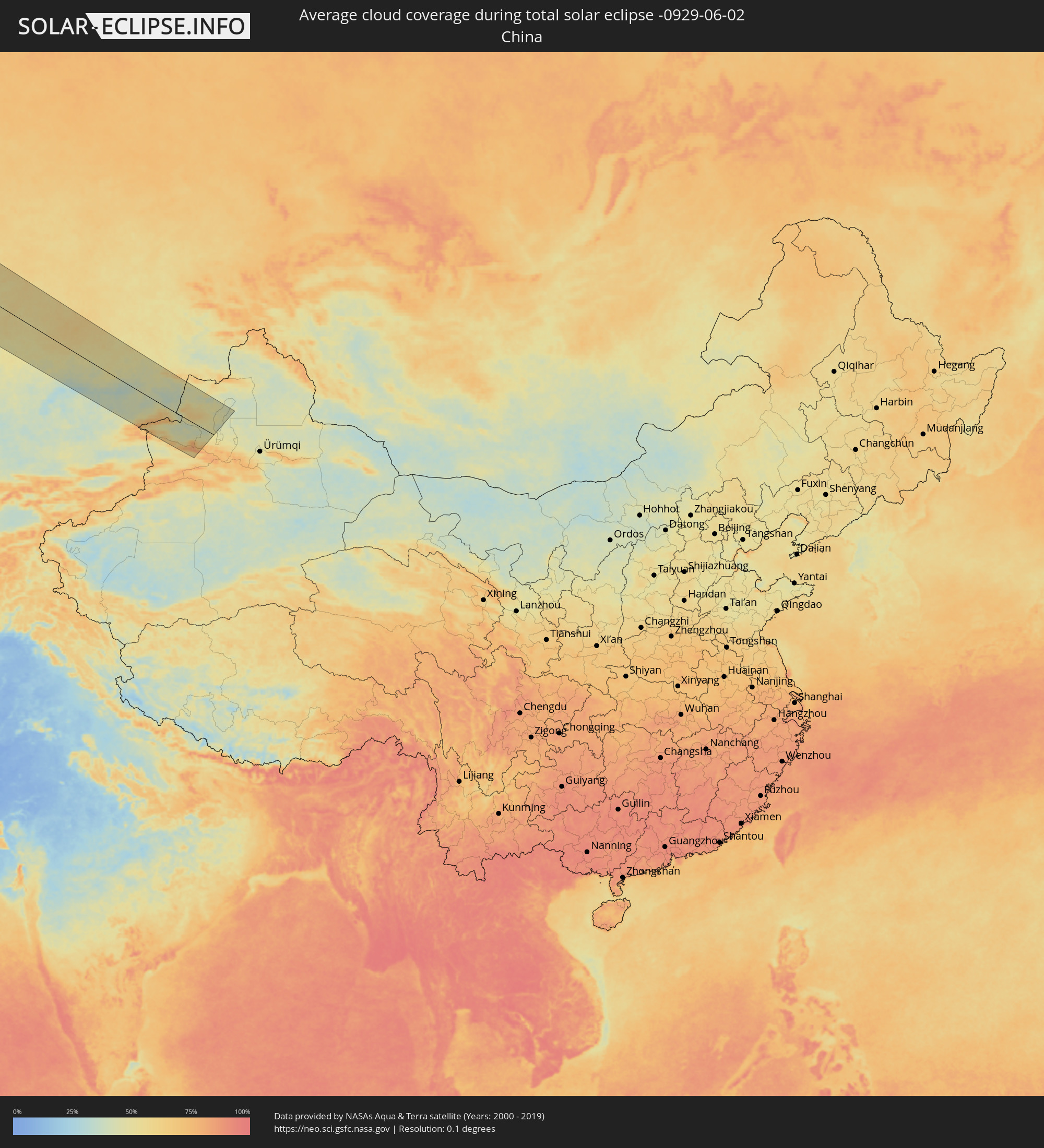 Volksrepublik China
Orte im Finsternispfad
Die nachfolgene Tabelle zeigt Städte und Orte mit mehr als 5.000 Einwohnern, die sich im Finsternispfad befinden. Städte mit mehr als 100.000 Einwohnern sind dick gekennzeichnet. Mit einem Klick auf den Ort öffnet sich eine Detailkarte die die Lage des jeweiligen Ortes zusammen mit dem Verlauf der zentralen Finsternis präsentiert.
| Ort | Typ | Dauer der Verfinsterung | Ortszeit bei maximaler Verfinsterung | Entfernung zur Zentrallinie | Ø Bewölkung |
|
Little Rock, Arkansas
|
total | - | 05:08:27 UTC-06:00 | 132 km | 63% |
|
Memphis, Tennessee
|
total | - | 05:08:06 UTC-06:00 | 81 km | 70% |
|
Clarksville, Tennessee
|
total | - | 05:08:54 UTC-06:00 | 104 km | 66% |
|
Nashville, Tennessee
|
total | - | 05:08:18 UTC-06:00 | 42 km | 73% |
|
Huntsville, Alabama
|
total | - | 05:06:30 UTC-06:00 | 108 km | 70% |
|
Chattanooga, Tennessee
|
total | - | 06:06:31 UTC-05:00 | 131 km | 68% |
|
Lexington-Fayette, Kentucky
|
total | - | 06:10:06 UTC-05:00 | 126 km | 72% |
|
Knoxville, Tennessee
|
total | - | 06:07:19 UTC-05:00 | 102 km | 63% |
|
Ironville, Kentucky
|
total | - | 06:10:18 UTC-05:00 | 85 km | 63% |
|
Pittsburgh, Pennsylvania
|
total | - | 06:12:38 UTC-05:00 | 152 km | 70% |
|
Washington, D.C., Washington, D.C.
|
total | - | 06:10:15 UTC-05:00 | 130 km | 63% |
|
Baltimore, Maryland
|
total | - | 06:10:47 UTC-05:00 | 113 km | 61% |
|
Philadelphia, Pennsylvania
|
total | - | 06:11:42 UTC-05:00 | 116 km | 65% |
|
Paterson, New Jersey
|
total | - | 06:13:07 UTC-05:00 | 72 km | 65% |
|
Staten Island, New York
|
total | - | 06:12:36 UTC-05:00 | 107 km | 64% |
|
New York City, New York
|
total | - | 06:12:50 UTC-05:00 | 98 km | 66% |
|
The Bronx, New York
|
total | - | 06:13:02 UTC-05:00 | 92 km | 64% |
|
Jamaica, New York
|
total | - | 06:12:48 UTC-05:00 | 110 km | 60% |
|
Bridgeport, Connecticut
|
total | - | 06:13:32 UTC-05:00 | 95 km | 58% |
|
Springfield, Massachusetts
|
total | - | 06:14:59 UTC-05:00 | 39 km | 61% |
|
Worcester, Massachusetts
|
total | - | 06:15:18 UTC-05:00 | 60 km | 58% |
|
Providence, Rhode Island
|
total | - | 06:14:40 UTC-05:00 | 117 km | 59% |
|
Boston, Massachusetts
|
total | - | 06:15:31 UTC-05:00 | 84 km | 62% |
|
Fredericton, New Brunswick
|
total | - | 07:07:35 UTC-04:14 | 41 km | 66% |
|
Oromocto, New Brunswick
|
total | - | 07:07:27 UTC-04:14 | 27 km | 69% |
|
Saint John, New Brunswick
|
total | - | 07:06:39 UTC-04:14 | 49 km | 66% |
|
Bathurst, New Brunswick
|
total | - | 07:10:34 UTC-04:14 | 142 km | 73% |
|
Miramichi, New Brunswick
|
total | - | 07:09:39 UTC-04:14 | 84 km | 72% |
|
Greenwood, Nova Scotia
|
total | - | 07:06:29 UTC-04:14 | 128 km | 61% |
|
Lutes Mountain, New Brunswick
|
total | - | 07:08:22 UTC-04:14 | 26 km | 72% |
|
Moncton, New Brunswick
|
total | - | 07:08:20 UTC-04:14 | 33 km | 72% |
|
Dieppe, New Brunswick
|
total | - | 07:08:21 UTC-04:14 | 39 km | 72% |
|
Chandler, Quebec
|
total | - | 06:26:28 UTC-05:00 | 163 km | 74% |
|
Kentville, Nova Scotia
|
total | - | 07:06:47 UTC-04:14 | 138 km | 63% |
|
Sackville, New Brunswick
|
total | - | 07:08:11 UTC-04:14 | 68 km | 67% |
|
Amherst, Nova Scotia
|
total | - | 07:08:06 UTC-04:14 | 85 km | 67% |
|
Summerside, Prince Edward Island
|
total | - | 07:09:09 UTC-04:14 | 55 km | 70% |
|
Truro, Nova Scotia
|
total | - | 07:07:39 UTC-04:14 | 168 km | 68% |
|
Charlottetown, Prince Edward Island
|
total | - | 07:09:07 UTC-04:14 | 96 km | 72% |
|
Stephenville, Newfoundland and Labrador
|
total | - | 07:58:20 UTC-03:30 | 92 km | 79% |
|
Corner Brook, Newfoundland and Labrador
|
total | - | 07:59:19 UTC-03:30 | 83 km | 77% |
|
Miðvágur, Vágar
|
total | - | 12:06:47 UTC-00:27 | 155 km | 86% |
|
Fuglafjørður, Eysturoy
|
total | - | 12:07:12 UTC-00:27 | 137 km | 88% |
|
Tórshavn, Streymoy
|
total | - | 12:07:13 UTC-00:27 | 163 km | 87% |
|
Klaksvík, Norðoyar
|
total | - | 12:07:26 UTC-00:27 | 140 km | 87% |
|
Ålesund, Møre og Romsdal
|
total | - | 13:47:32 UTC+01:00 | 152 km | 78% |
|
Molde, Møre og Romsdal
|
total | - | 13:48:22 UTC+01:00 | 121 km | 80% |
|
Kristiansund, Møre og Romsdal
|
total | - | 13:48:42 UTC+01:00 | 78 km | 76% |
|
Trondheim, Sør-Trøndelag
|
total | - | 13:50:57 UTC+01:00 | 34 km | 73% |
|
Malvik, Sør-Trøndelag
|
total | - | 13:51:13 UTC+01:00 | 34 km | 73% |
|
Stjørdalshalsen, Nord-Trøndelag
|
total | - | 13:51:25 UTC+01:00 | 27 km | 73% |
|
Levanger, Nord-Trøndelag
|
total | - | 13:51:32 UTC+01:00 | 12 km | 75% |
|
Verdal, Nord-Trøndelag
|
total | - | 13:51:40 UTC+01:00 | 11 km | 73% |
|
Steinkjer, Nord-Trøndelag
|
total | - | 13:51:31 UTC+01:00 | 36 km | 73% |
|
Namsos, Nord-Trøndelag
|
total | - | 13:51:11 UTC+01:00 | 86 km | 75% |
|
Östersund, Jämtland
|
total | - | 13:54:54 UTC+01:00 | 40 km | 64% |
|
Sollefteå, Västernorrland
|
total | - | 13:57:08 UTC+01:00 | 22 km | 60% |
|
Sundsvall, Västernorrland
|
total | - | 13:57:54 UTC+01:00 | 105 km | 60% |
|
Timrå, Västernorrland
|
total | - | 13:57:49 UTC+01:00 | 94 km | 59% |
|
Kramfors, Västernorrland
|
total | - | 13:57:47 UTC+01:00 | 41 km | 58% |
|
Härnösand, Västernorrland
|
total | - | 13:58:12 UTC+01:00 | 73 km | 63% |
|
Lycksele, Västerbotten
|
total | - | 13:56:52 UTC+01:00 | 149 km | 65% |
|
Örnsköldsvik, Västernorrland
|
total | - | 13:58:12 UTC+01:00 | 12 km | 63% |
|
Umeå, Västerbotten
|
total | - | 13:58:51 UTC+01:00 | 80 km | 62% |
|
Holmsund, Västerbotten
|
total | - | 13:59:04 UTC+01:00 | 68 km | 70% |
|
Vaasa, Ostrobothnia
|
total | - | 14:40:30 UTC+01:39 | 15 km | 58% |
|
Pori, Satakunta
|
total | - | 14:42:23 UTC+01:39 | 158 km | 53% |
|
Jakobstad, Ostrobothnia
|
total | - | 14:40:40 UTC+01:39 | 91 km | 54% |
|
Seinäjoki, Southern Ostrobothnia
|
total | - | 14:41:45 UTC+01:39 | 9 km | 60% |
|
Kokkola, Central Ostrobothnia
|
total | - | 14:40:48 UTC+01:39 | 113 km | 53% |
|
Nokia, Pirkanmaa
|
total | - | 14:43:47 UTC+01:39 | 139 km | 61% |
|
Lempäälä, Pirkanmaa
|
total | - | 14:44:09 UTC+01:39 | 152 km | 61% |
|
Tampere, Pirkanmaa
|
total | - | 14:43:58 UTC+01:39 | 132 km | 61% |
|
Valkeakoski, Pirkanmaa
|
total | - | 14:44:26 UTC+01:39 | 155 km | 61% |
|
Kangasala, Pirkanmaa
|
total | - | 14:44:14 UTC+01:39 | 132 km | 62% |
|
Lahti, Päijänne Tavastia
|
total | - | 14:46:01 UTC+01:39 | 162 km | 62% |
|
Jyväskylä, Central Finland
|
total | - | 14:44:33 UTC+01:39 | 27 km | 62% |
|
Heinola, Päijänne Tavastia
|
total | - | 14:46:02 UTC+01:39 | 133 km | 62% |
|
Kouvola, Kymenlaakso
|
total | - | 14:46:57 UTC+01:39 | 159 km | 61% |
|
Iisalmi, Northern Savo
|
total | - | 14:43:57 UTC+01:39 | 135 km | 63% |
|
Mikkeli, Southern Savonia
|
total | - | 14:46:20 UTC+01:39 | 63 km | 61% |
|
Siilinjärvi, Northern Savo
|
total | - | 14:44:52 UTC+01:39 | 92 km | 64% |
|
Kuopio, Northern Savo
|
total | - | 14:45:07 UTC+01:39 | 72 km | 62% |
|
Varkaus, Northern Savo
|
total | - | 14:45:58 UTC+01:39 | 17 km | 60% |
|
Lappeenranta, South Karelia
|
total | - | 14:47:47 UTC+01:39 | 116 km | 59% |
|
Imatra, South Karelia
|
total | - | 14:48:02 UTC+01:39 | 96 km | 58% |
|
Vyborg, Leningradskaya Oblast'
|
total | - | 15:39:06 UTC+02:30 | 145 km | 60% |
|
Savonlinna, Southern Savonia
|
total | - | 14:47:14 UTC+01:39 | 19 km | 61% |
|
Joensuu, North Karelia
|
total | - | 14:46:52 UTC+01:39 | 73 km | 63% |
|
Petrozavodsk, Republic of Karelia
|
total | - | 15:41:16 UTC+02:30 | 67 km | 67% |
|
Cherepovets, Vologda
|
total | - | 15:47:04 UTC+02:30 | 136 km | 66% |
|
Vologda, Vologda
|
total | - | 15:47:59 UTC+02:30 | 82 km | 69% |
|
Yoshkar-Ola, Mariy-El
|
total | - | 15:55:22 UTC+02:30 | 139 km | 64% |
|
Kirov, Kirov
|
total | - | 15:52:58 UTC+02:30 | 104 km | 68% |
|
Kirovo-Chepetsk, Kirov
|
total | - | 15:53:09 UTC+02:30 | 110 km | 68% |
|
Nizhnekamsk, Tatarstan
|
total | - | 15:58:07 UTC+02:30 | 125 km | 59% |
|
Yelabuga, Tatarstan
|
total | - | 15:58:00 UTC+02:30 | 105 km | 61% |
|
Naberezhnyye Chelny, Tatarstan
|
total | - | 15:58:08 UTC+02:30 | 98 km | 62% |
|
Glazov, Udmurtiya
|
total | - | 16:44:34 UTC+03:20 | 144 km | 67% |
|
Izhevsk, Udmurtiya
|
total | - | 16:46:41 UTC+03:20 | 36 km | 67% |
|
Sarapul, Udmurtiya
|
total | - | 16:47:23 UTC+03:20 | 21 km | 63% |
|
Votkinsk, Udmurtiya
|
total | - | 16:46:34 UTC+03:20 | 79 km | 66% |
|
Chaykovskiy, Perm
|
total | - | 17:29:14 UTC+04:02 | 56 km | 68% |
|
Neftekamsk, Bashkortostan
|
total | - | 17:30:18 UTC+04:02 | 6 km | 64% |
|
Ufa, Bashkortostan
|
total | - | 17:32:40 UTC+04:02 | 84 km | 63% |
|
Beloretsk, Bashkortostan
|
total | - | 17:34:13 UTC+04:02 | 80 km | 67% |
|
Magnitogorsk, Chelyabinsk
|
total | - | 17:35:05 UTC+04:02 | 111 km | 59% |
|
Zlatoust, Chelyabinsk
|
total | - | 17:32:34 UTC+04:02 | 77 km | 73% |
|
Miass, Chelyabinsk
|
total | - | 17:32:49 UTC+04:02 | 80 km | 69% |
|
Dzhetygara, Qostanay
|
total | - | 17:56:23 UTC+04:21 | 156 km | 58% |
|
Chelyabinsk, Chelyabinsk
|
total | - | 17:32:46 UTC+04:02 | 135 km | 69% |
|
Troitsk, Chelyabinsk
|
total | - | 17:34:20 UTC+04:02 | 44 km | 62% |
|
Komsomolets, Qostanay
|
total | - | 17:54:11 UTC+04:21 | 25 km | 58% |
|
Lisakovsk, Qostanay
|
total | - | 17:55:56 UTC+04:21 | 77 km | 57% |
|
Kachar, Qostanay
|
total | - | 17:54:46 UTC+04:21 | 24 km | 56% |
|
Rudnyy, Qostanay
|
total | - | 17:55:21 UTC+04:21 | 23 km | 55% |
|
Kostanay, Qostanay
|
total | - | 17:55:01 UTC+04:21 | 27 km | 57% |
|
Borovskoy, Qostanay
|
total | - | 17:54:11 UTC+04:21 | 101 km | 50% |
|
Derzhavīnsk, Aqmola
|
total | - | 17:57:57 UTC+04:21 | 80 km | 50% |
|
Esil, Aqmola
|
total | - | 17:56:46 UTC+04:21 | 12 km | 55% |
|
Arkalyk, Qostanay
|
total | - | 17:59:04 UTC+04:21 | 138 km | 49% |
|
Atbasar, Aqmola
|
total | - | 17:56:51 UTC+04:21 | 63 km | 58% |
|
Astana, Astana Qalasy
|
total | - | 17:57:21 UTC+04:21 | 117 km | 59% |
|
Atasū, Qaraghandy
|
total | - | 18:00:34 UTC+04:21 | 112 km | 49% |
|
Aktau, Qaraghandy
|
total | - | 18:01:11 UTC+04:21 | 129 km | 49% |
|
Sorang, Qaraghandy
|
total | - | 17:58:57 UTC+04:21 | 38 km | 53% |
|
Aqadyr, Qaraghandy
|
total | - | 18:00:53 UTC+04:21 | 106 km | 49% |
|
Abay, Qaraghandy
|
total | - | 17:59:09 UTC+04:21 | 25 km | 51% |
|
Aqtas, Qaraghandy
|
total | - | 17:58:57 UTC+04:21 | 42 km | 55% |
|
Temirtau, Qaraghandy
|
total | - | 17:58:35 UTC+04:21 | 68 km | 57% |
|
Aqtaū, Qaraghandy
|
total | - | 17:58:20 UTC+04:21 | 89 km | 55% |
|
Karagandy, Qaraghandy
|
total | - | 17:58:50 UTC+04:21 | 55 km | 54% |
|
Sarkand, Almaty Oblysy
|
total | - | 18:02:22 UTC+04:21 | 106 km | 54% |
|
Urzhar, East Kazakhstan
|
total | - | 17:59:53 UTC+04:21 | 124 km | 45% |
|
Baijiantan, Xinjiang Uyghur Autonomous Region
|
total | - | 21:38:12 UTC+08:00 | 126 km | 45% |