Totale Sonnenfinsternis vom 18.07.-1229
| Wochentag: | Samstag |
| Maximale Dauer der Verfinsterung: | 04m49s |
| Maximale Breite des Finsternispfades: | 281 km |
| Saroszyklus: | 26 |
| Bedeckungsgrad: | 100% |
| Magnitude: | 1.0709 |
| Gamma: | 0.5689 |
Wo kann man die Sonnenfinsternis vom 18.07.-1229 sehen?

Die Sonnenfinsternis am 18.07.-1229 kann man in 110 Ländern als partielle Sonnenfinsternis beobachten.
Der Finsternispfad verläuft durch 12 Länder. Nur in diesen Ländern ist sie als totale Sonnenfinsternis zu sehen.
In den folgenden Ländern ist die Sonnenfinsternis total zu sehen
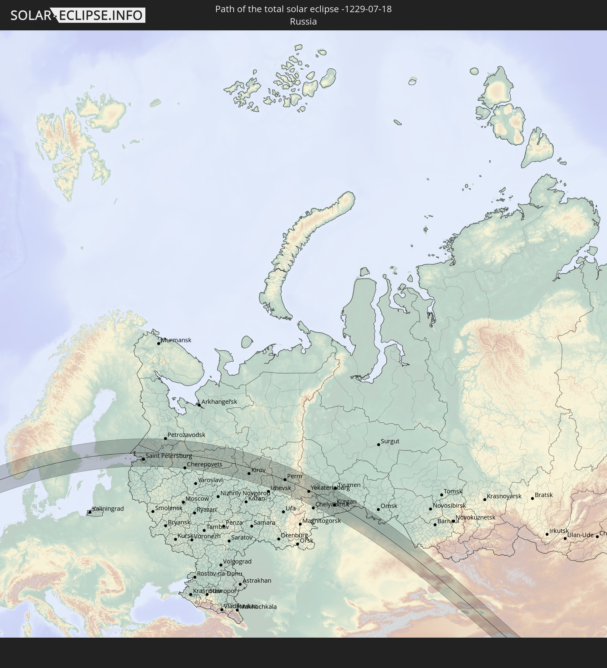 Russland
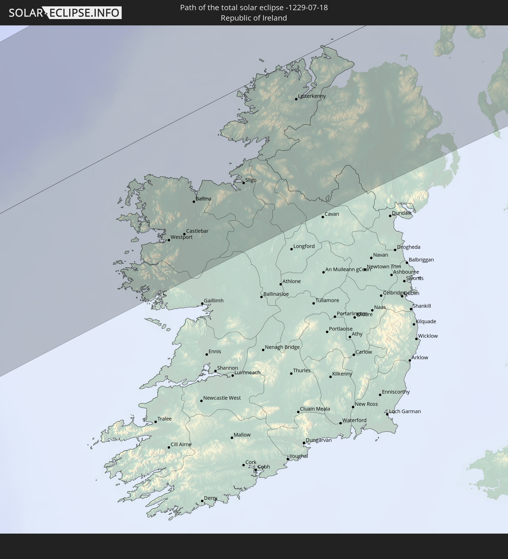 Irland
 Vereinigtes Königreich
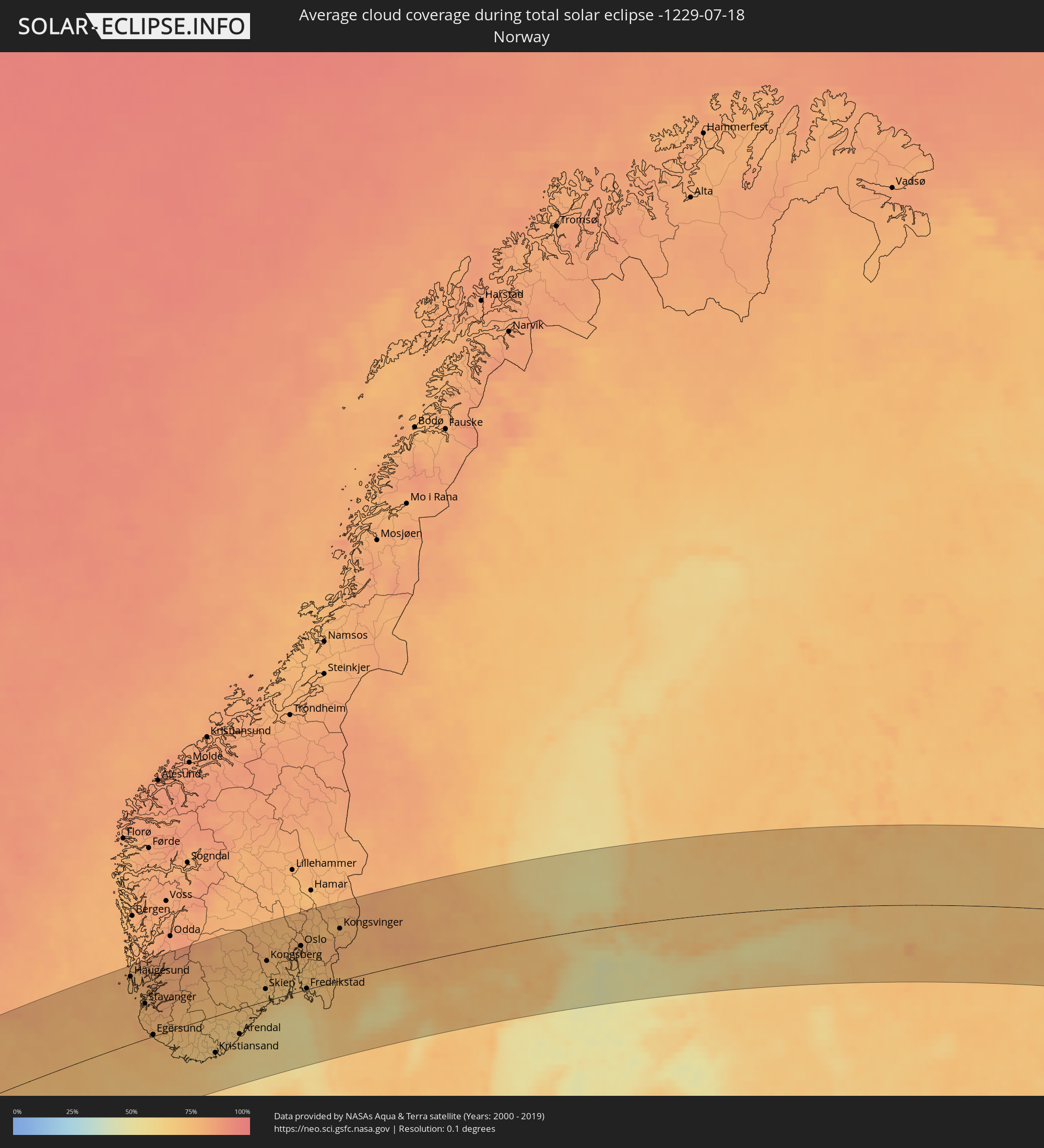
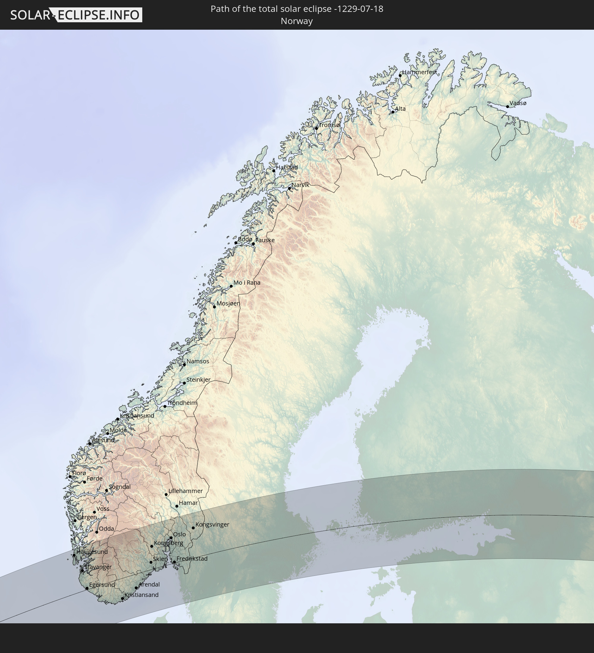 Norwegen
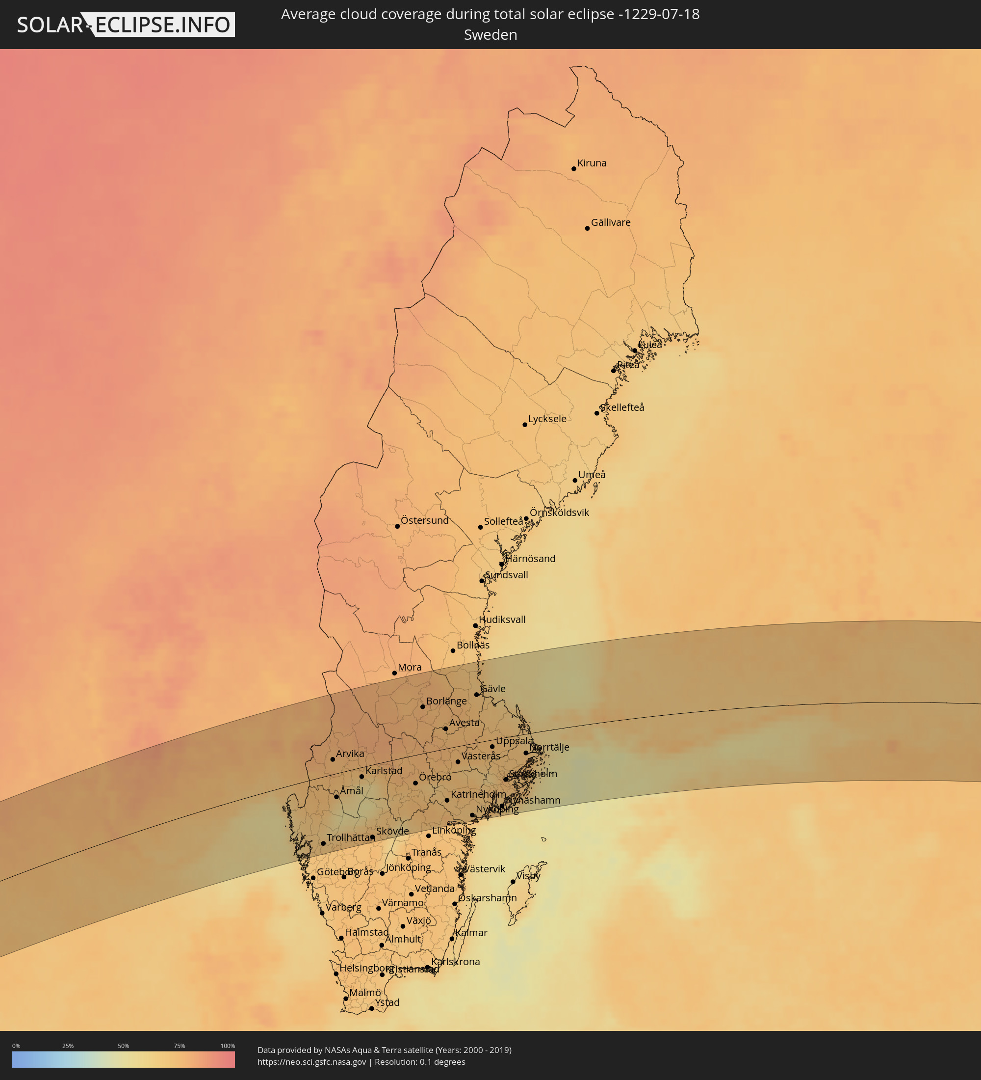
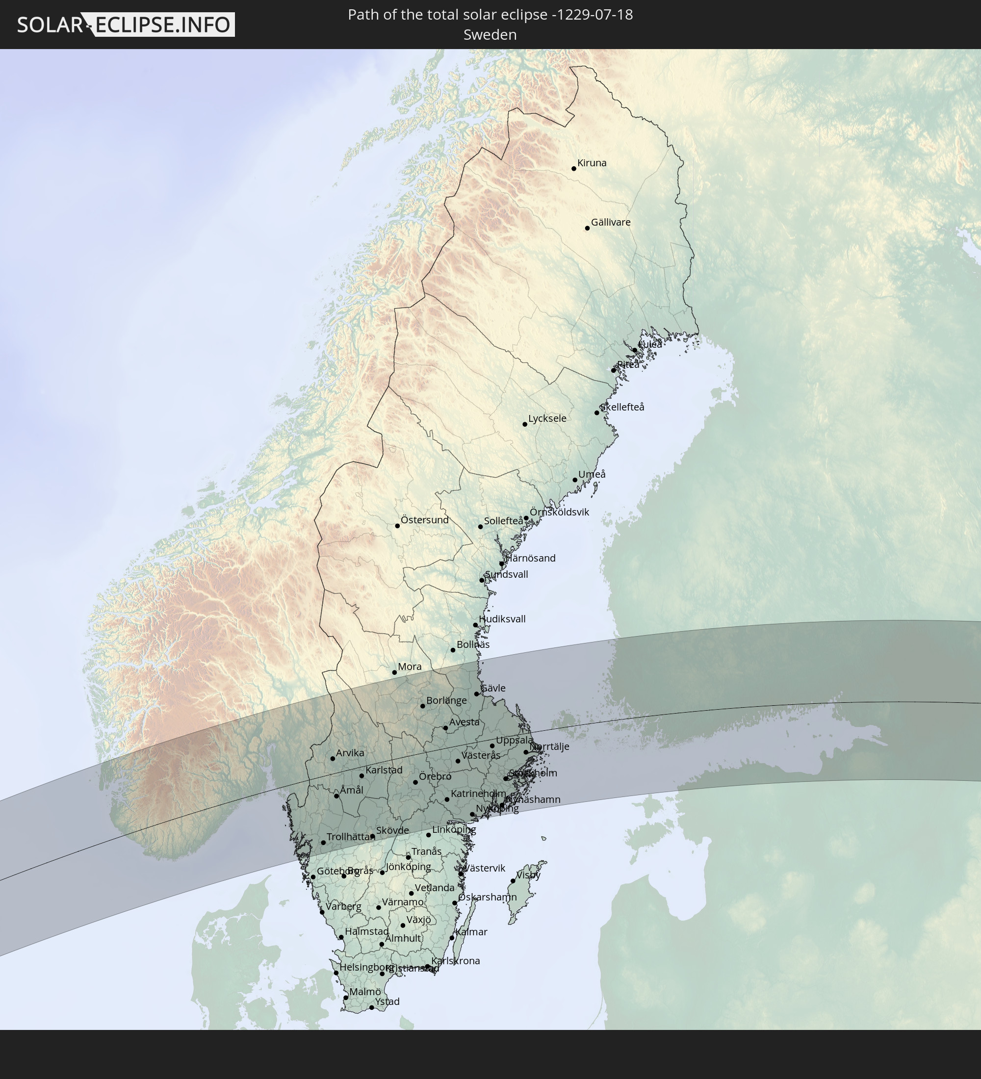 Schweden
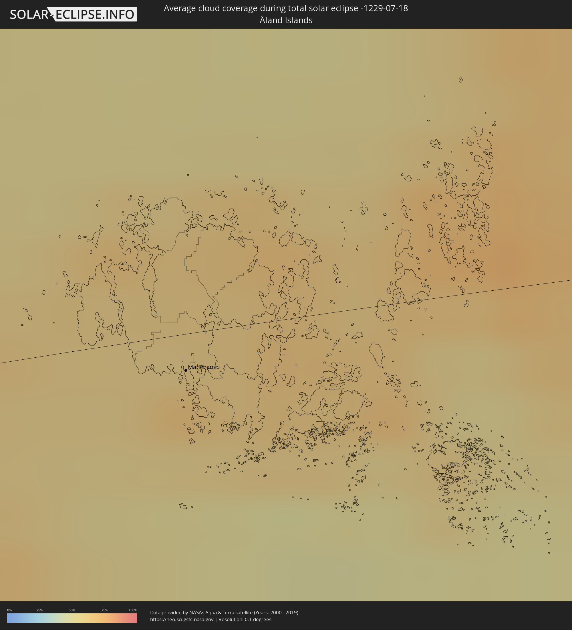
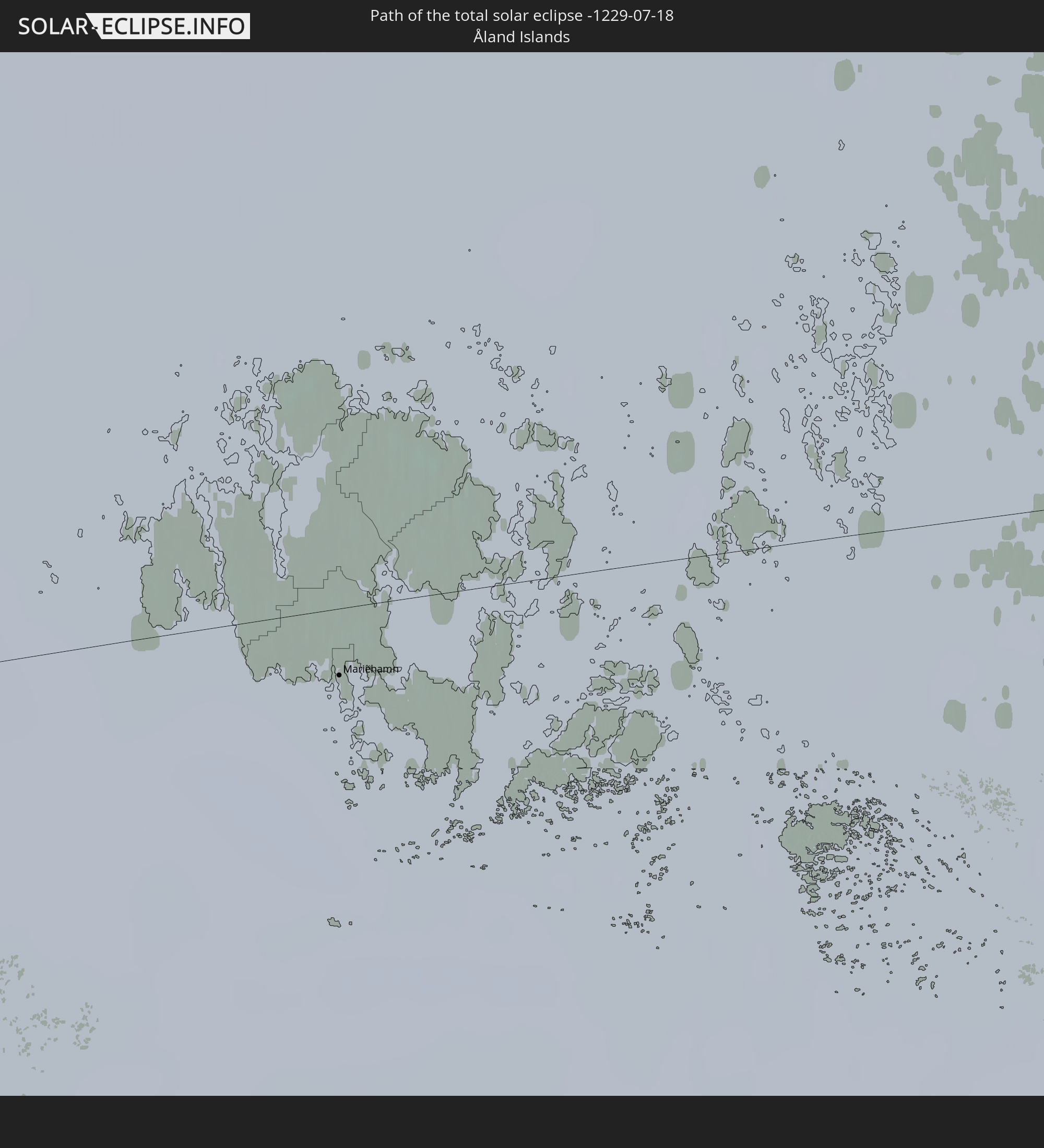 Åland Islands
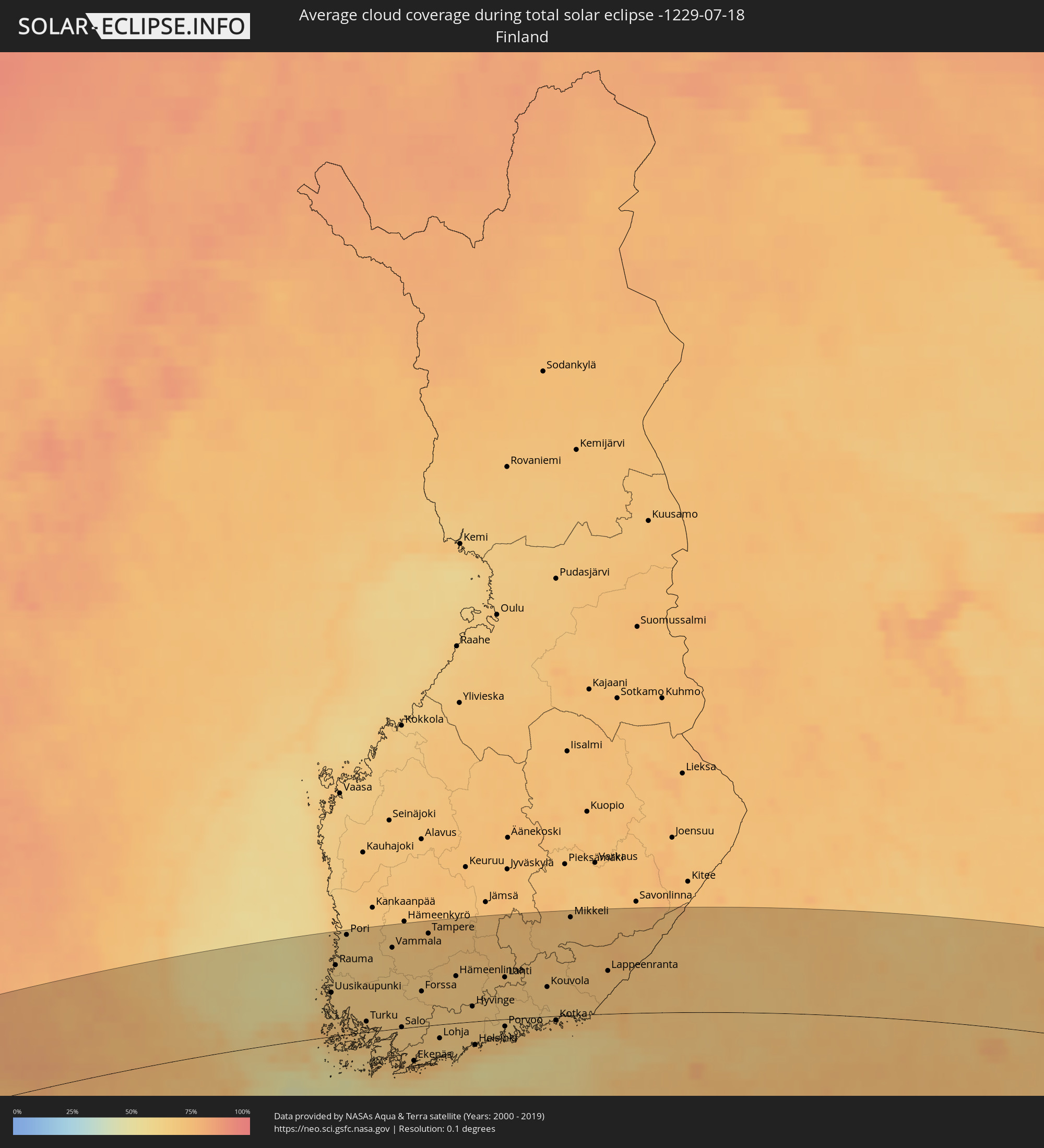
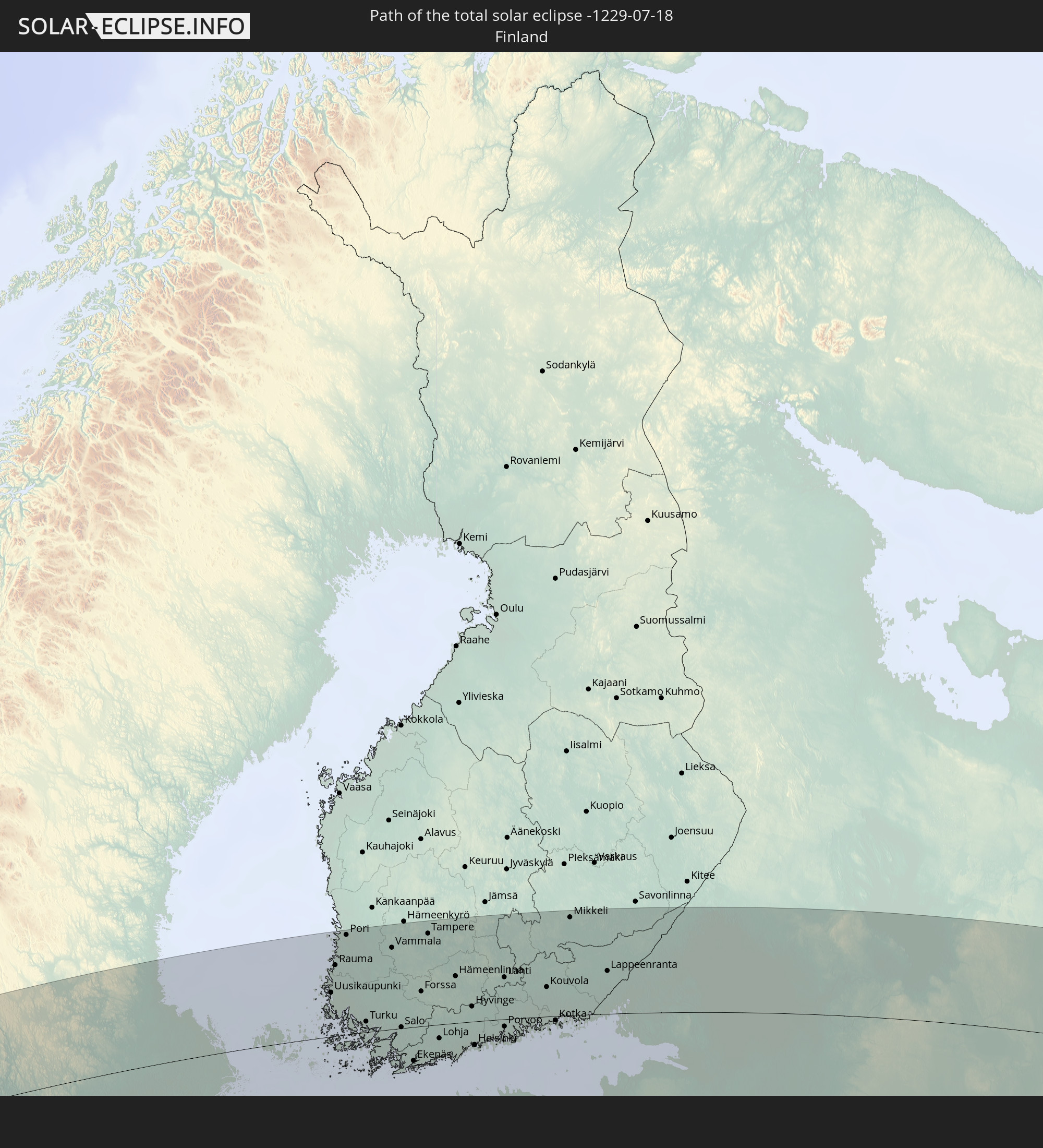 Finnland
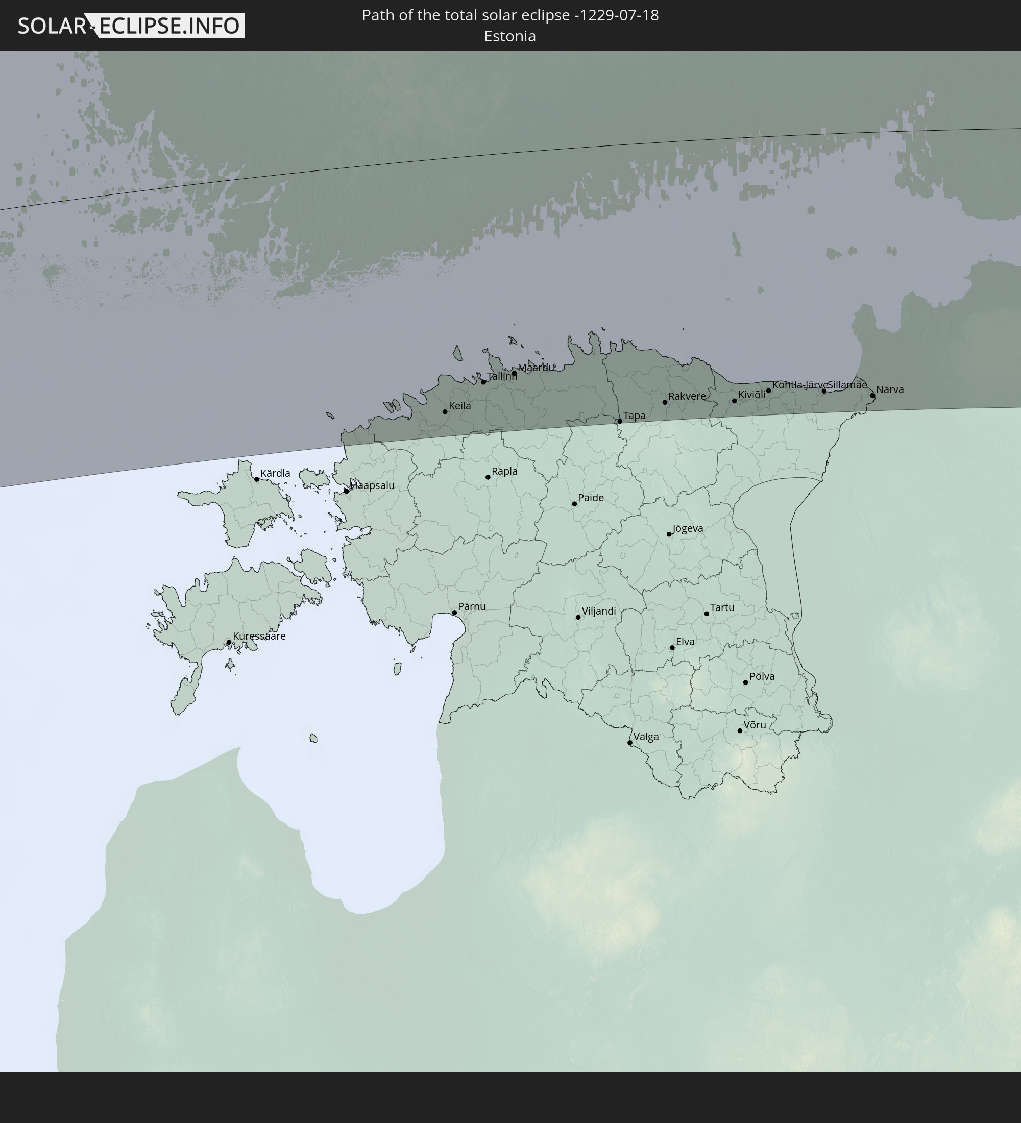 Estland
 Kasachstan
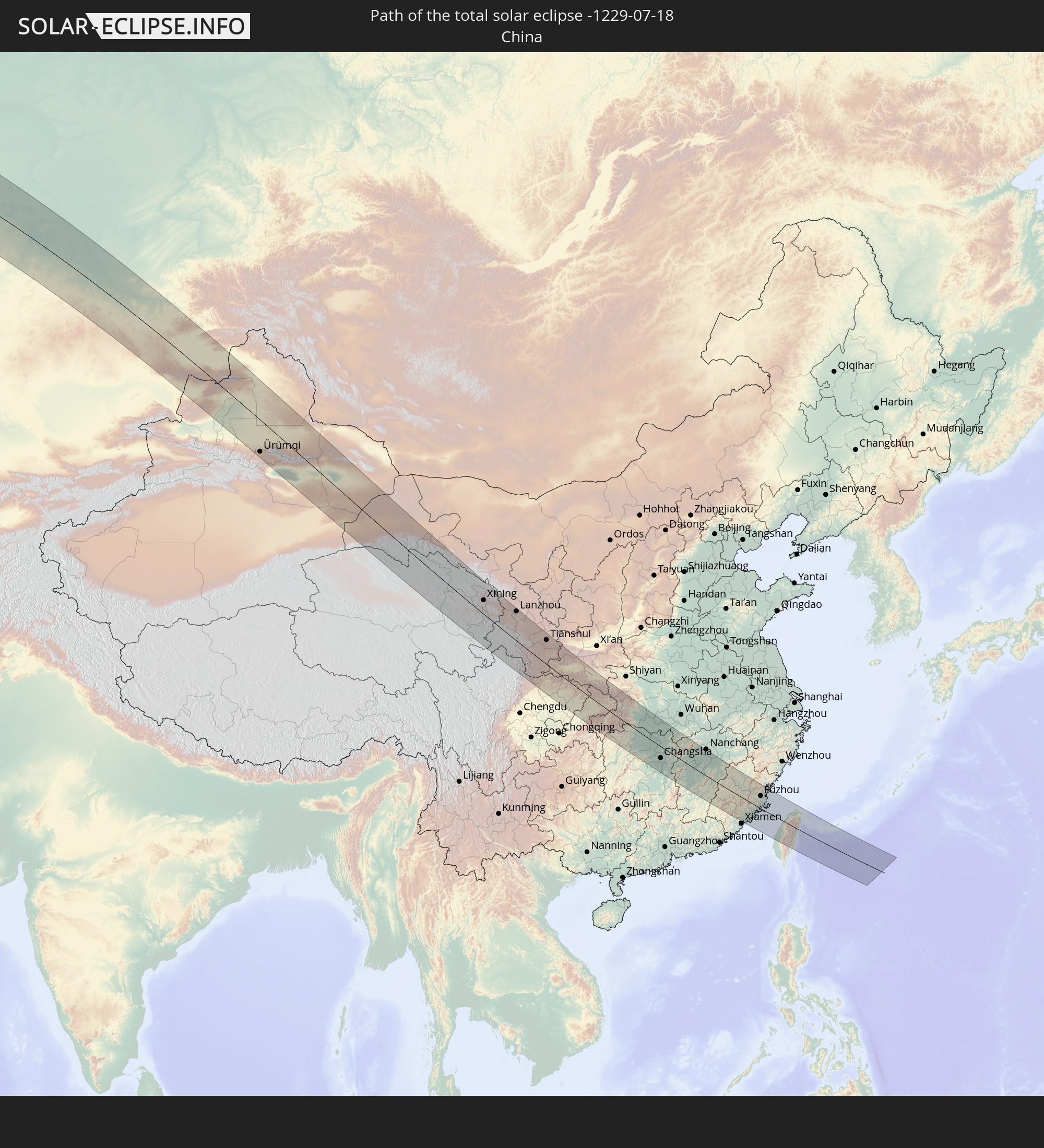 Volksrepublik China
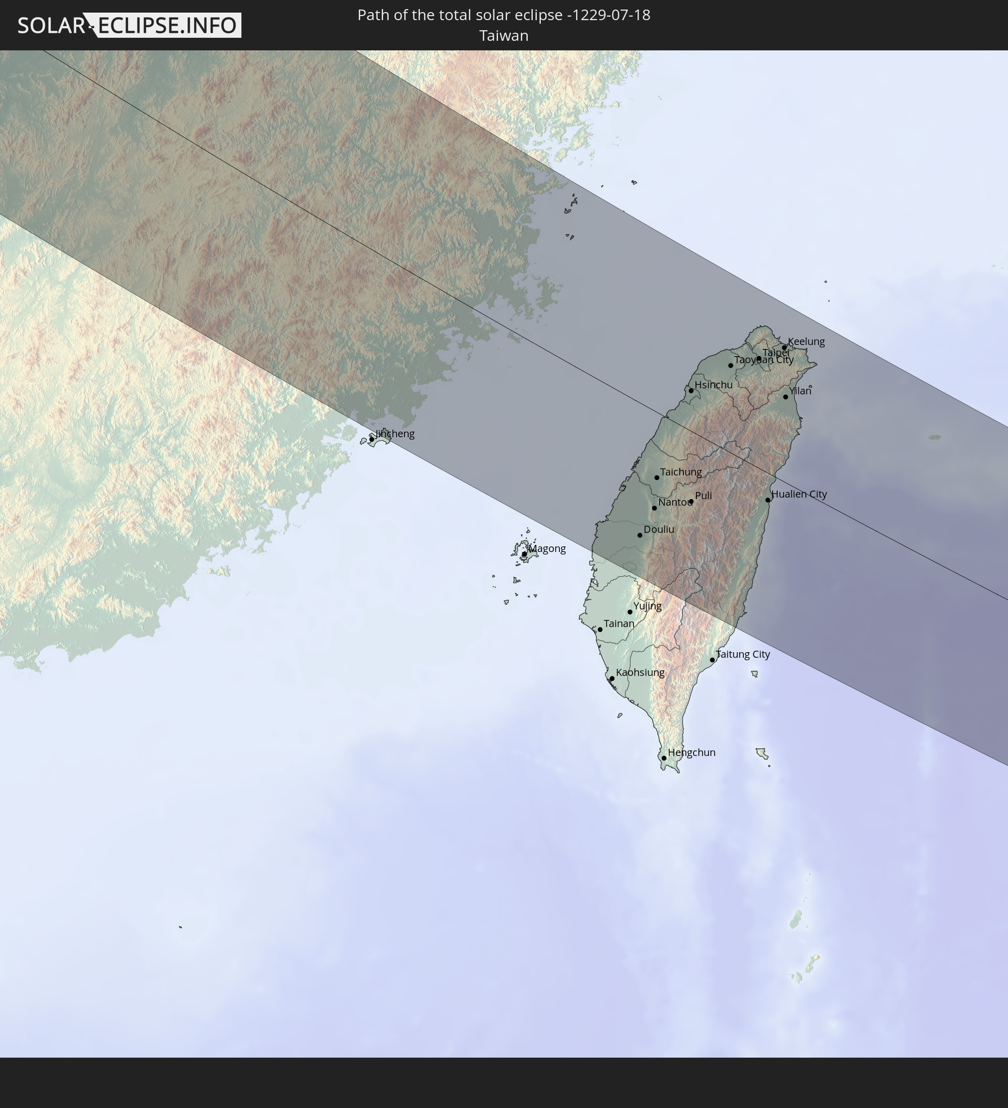 Taiwan
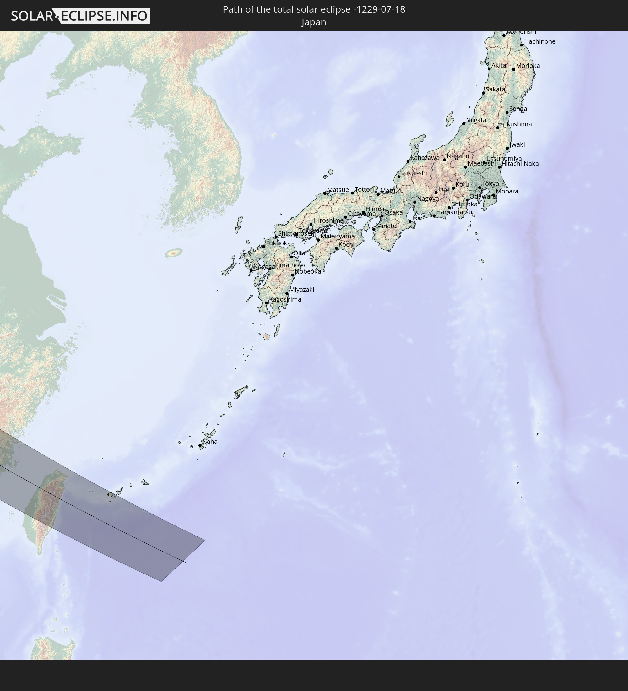 Japan
Japan
In den folgenden Ländern ist die Sonnenfinsternis partiell zu sehen
 Russland
 Vereinigte Staaten
 Kanada
 Grönland
 Portugal
 Island
 Spanien
 Senegal
 Mauretanien
 Marokko
 Mali
Mali
 Irland
 Spitzbergen
 Algerien
 Vereinigtes Königreich
 Färöer
 Gibraltar
 Frankreich
 Isle of Man
 Guernsey
 Jersey
 Andorra
 Belgien
 Niederlande
 Norwegen
 Luxemburg
 Deutschland
 Schweiz
 Italien
 Monaco
 Tunesien
 Dänemark
 Libyen
 Liechtenstein
 Österreich
 Schweden
 Tschechien
 San Marino
 Vatikanstadt
 Slowenien
 Kroatien
 Polen
Polen
 Malta
Malta
 Bosnien und Herzegowina
 Ungarn
 Slowakei
 Montenegro
 Serbien
 Albanien
 Åland Islands
 Griechenland
 Rumänien
 Mazedonien
 Finnland
 Litauen
 Lettland
 Estland
 Ukraine
 Bulgarien
 Weißrussland
 Ägypten
 Türkei
 Moldawien
 Republik Zypern
 Staat Palästina
 Israel
 Saudi-Arabien
 Jordanien
 Libanon
 Syrien
 Irak
Irak
 Georgien
 Armenien
 Iran
Iran
 Aserbaidschan
 Kasachstan
 Kuwait
 Bahrain
 Katar
Katar
 Vereinigte Arabische Emirate
 Oman
Oman
 Turkmenistan
 Usbekistan
 Afghanistan
 Pakistan
 Tadschikistan
 Indien
 Kirgisistan
 Volksrepublik China
 Sri Lanka
 Nepal
Nepal
 Mongolei
 Bangladesch
 Bhutan
 Myanmar
 Indonesien
 Thailand
 Malaysia
 Laos
Laos
 Vietnam
 Kambodscha
 Singapur
 Macau
Macau
 Hongkong
 Brunei
 Taiwan
 Philippinen
 Japan
Japan
 Nordkorea
 Südkorea
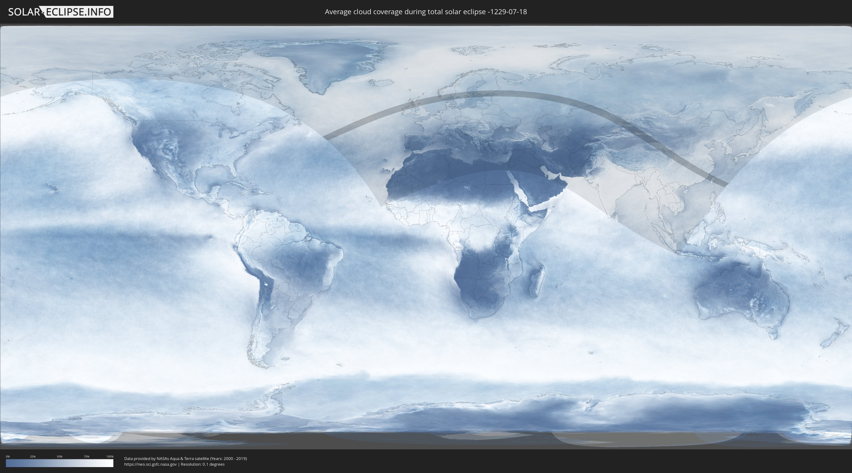
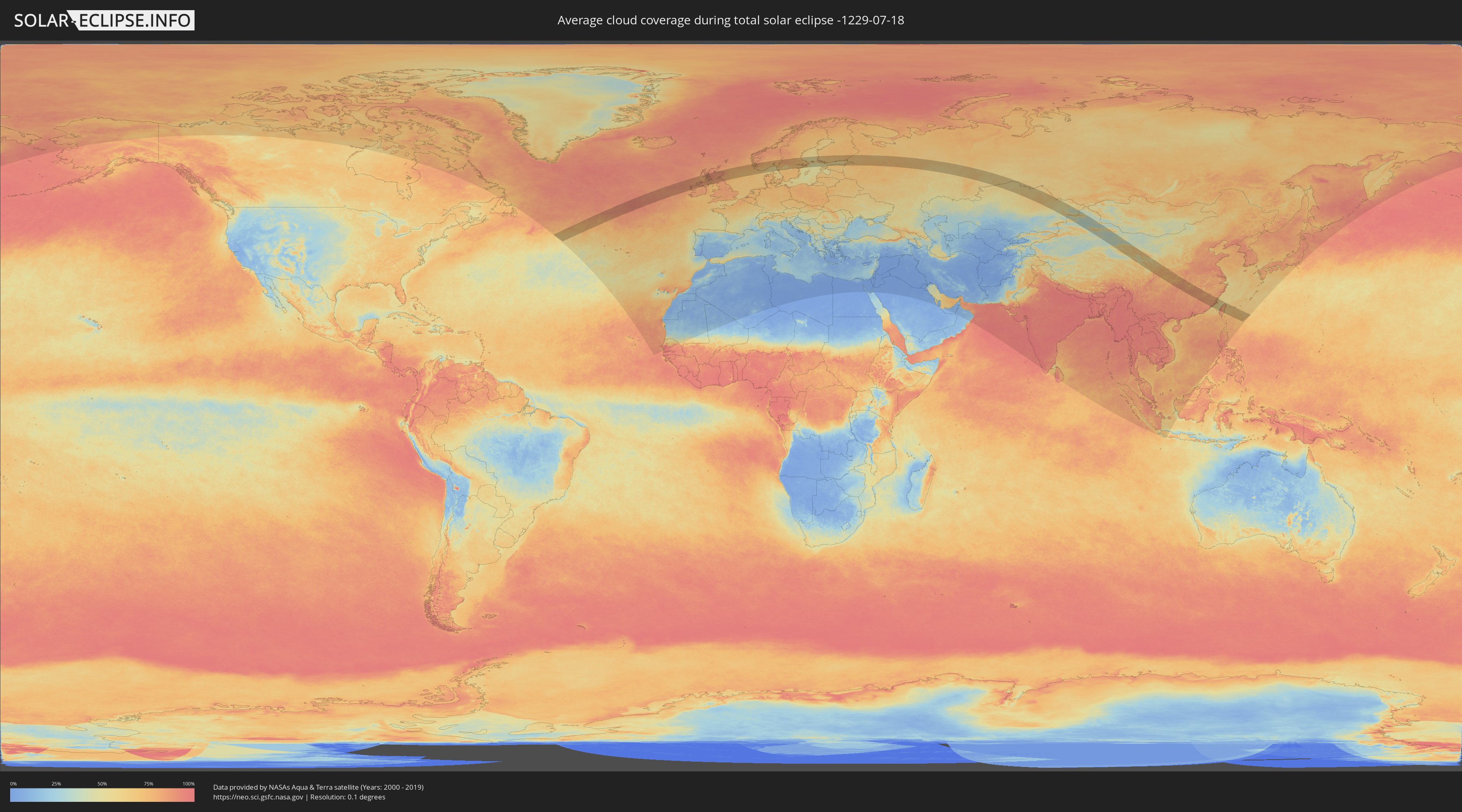
Wie wird das Wetter während der totalen Sonnenfinsternis am 18.07.-1229?
Wo ist der beste Ort, um die totale Sonnenfinsternis vom 18.07.-1229 zu beobachten?
Die folgenden Karten zeigen die durchschnittliche Bewölkung für den Tag, an dem die totale Sonnenfinsternis
stattfindet. Mit Hilfe der Karten lässt sich der Ort entlang des Finsternispfades eingrenzen,
der die besten Aussichen auf einen klaren wolkenfreien Himmel bietet.
Trotzdem muss man immer lokale Gegenenheiten beachten und sollte sich genau über das Wetter an seinem
gewählten Beobachtungsort informieren.
Die Daten stammen von den beiden NASA-Satelliten
AQUA und TERRA
und wurden über einen Zeitraum von 19 Jahren (2000 - 2019) gemittelt.
Detaillierte Länderkarten
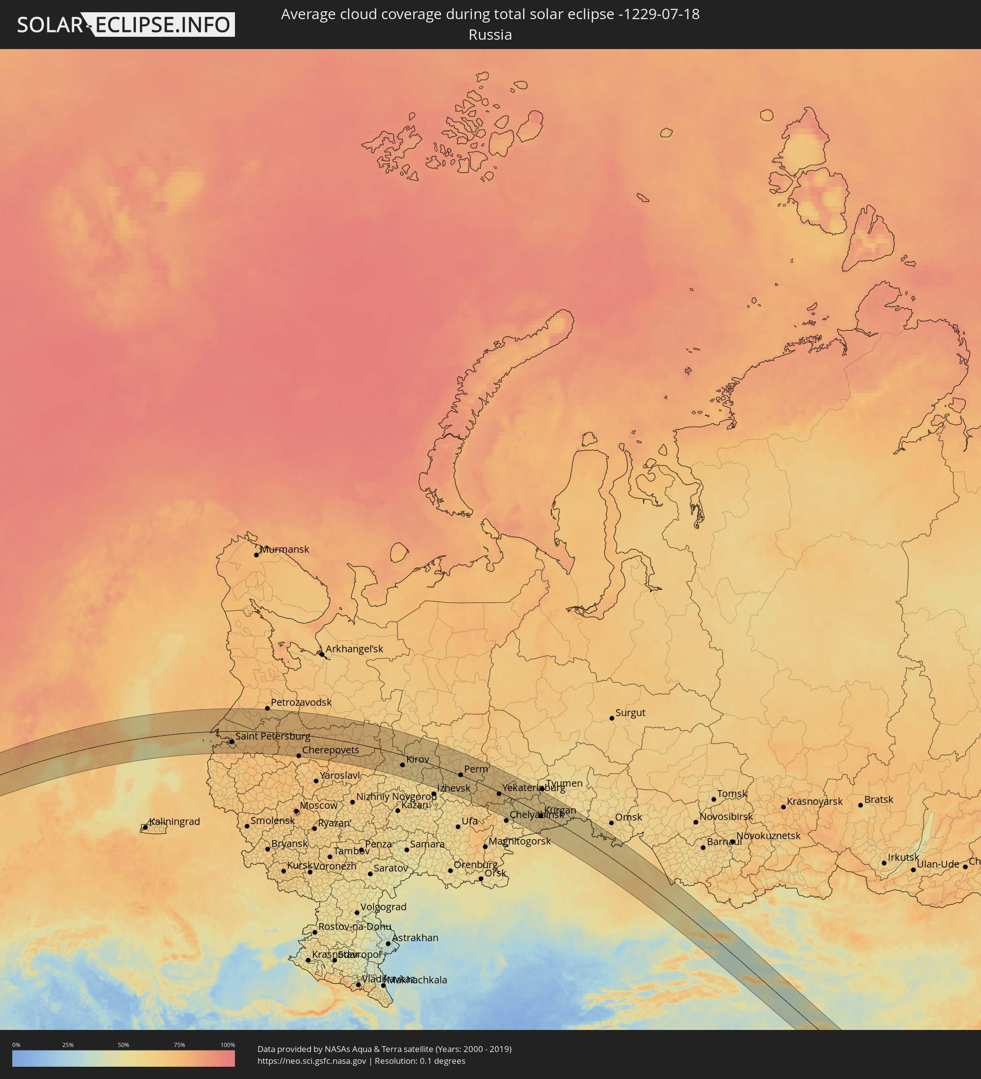 Russland
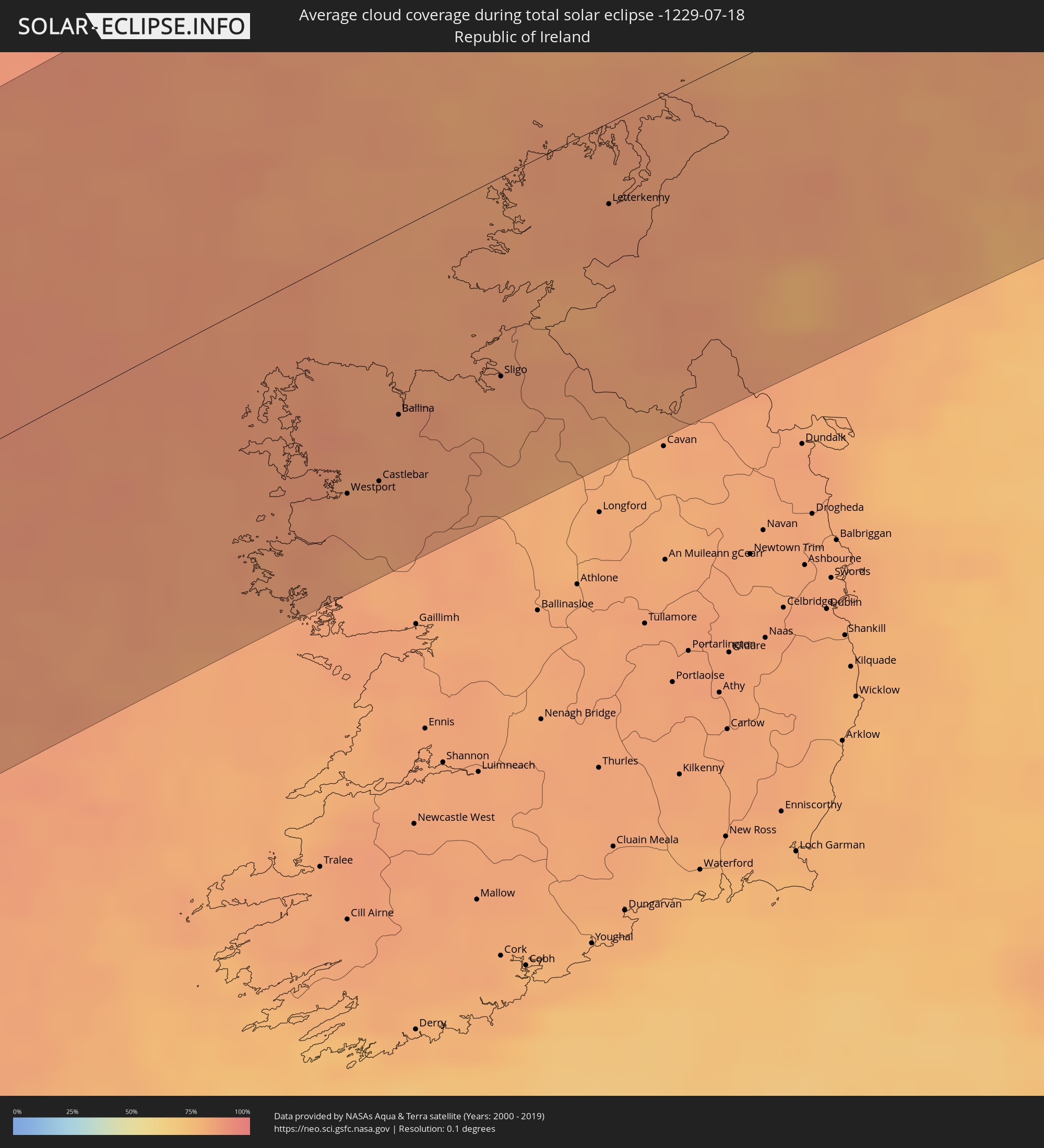 Irland
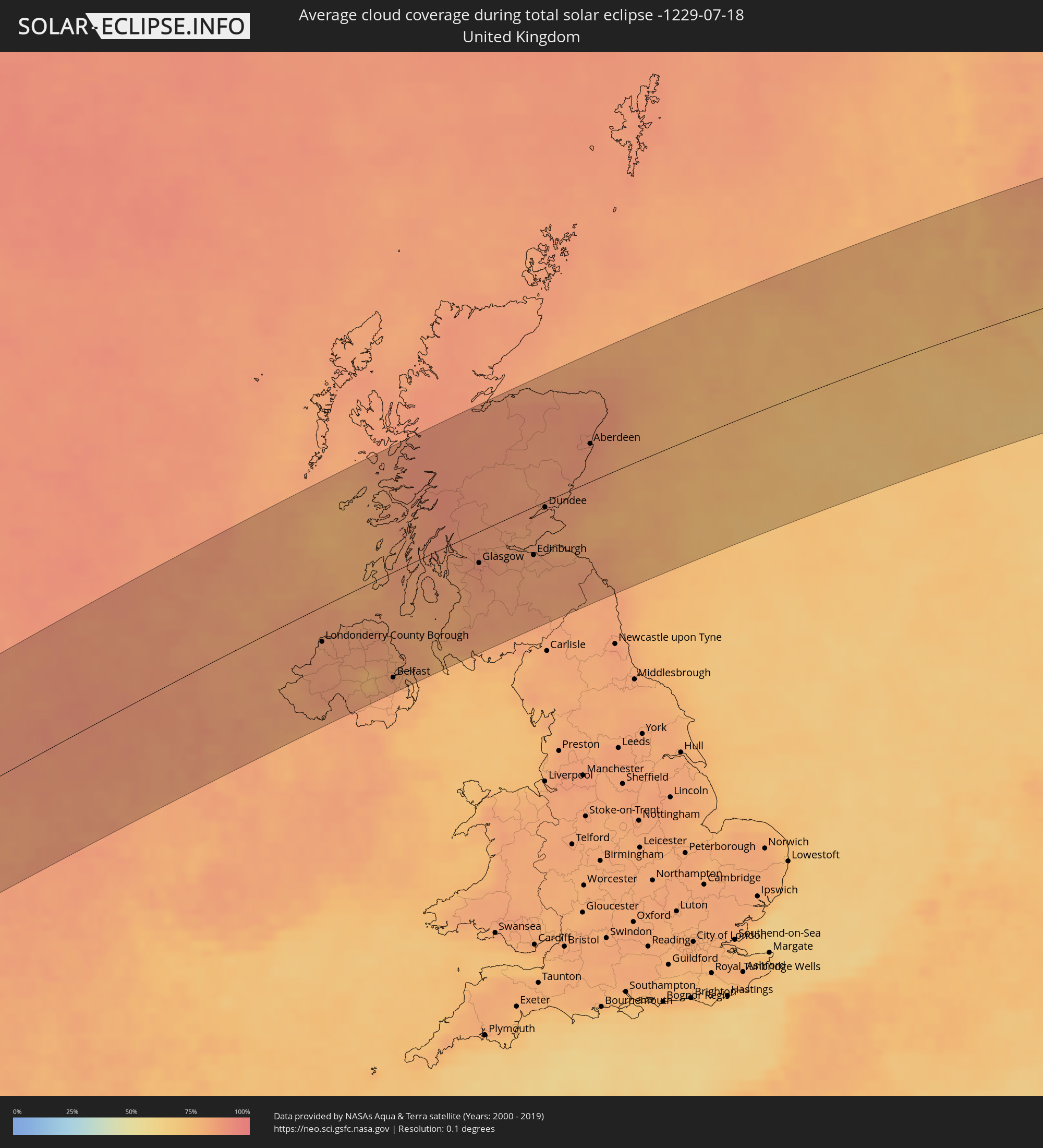 Vereinigtes Königreich
 Norwegen
 Schweden
 Åland Islands
 Finnland
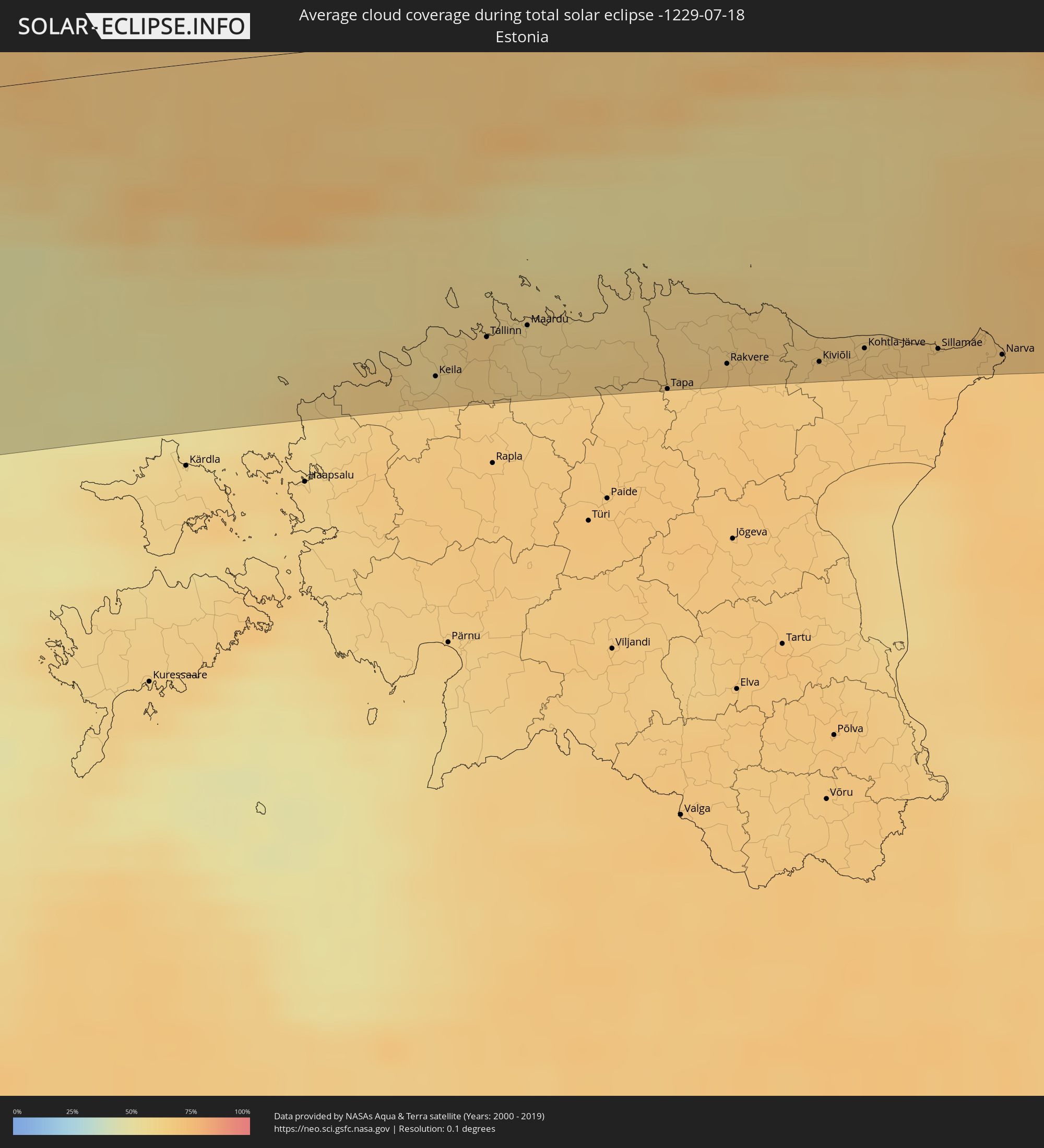 Estland
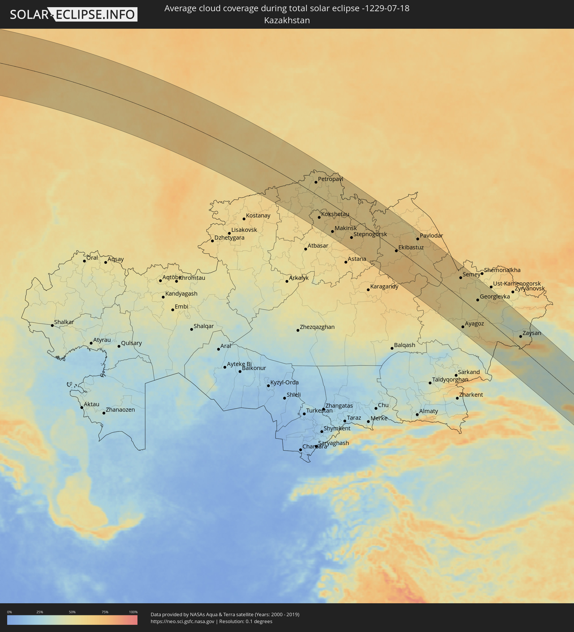 Kasachstan
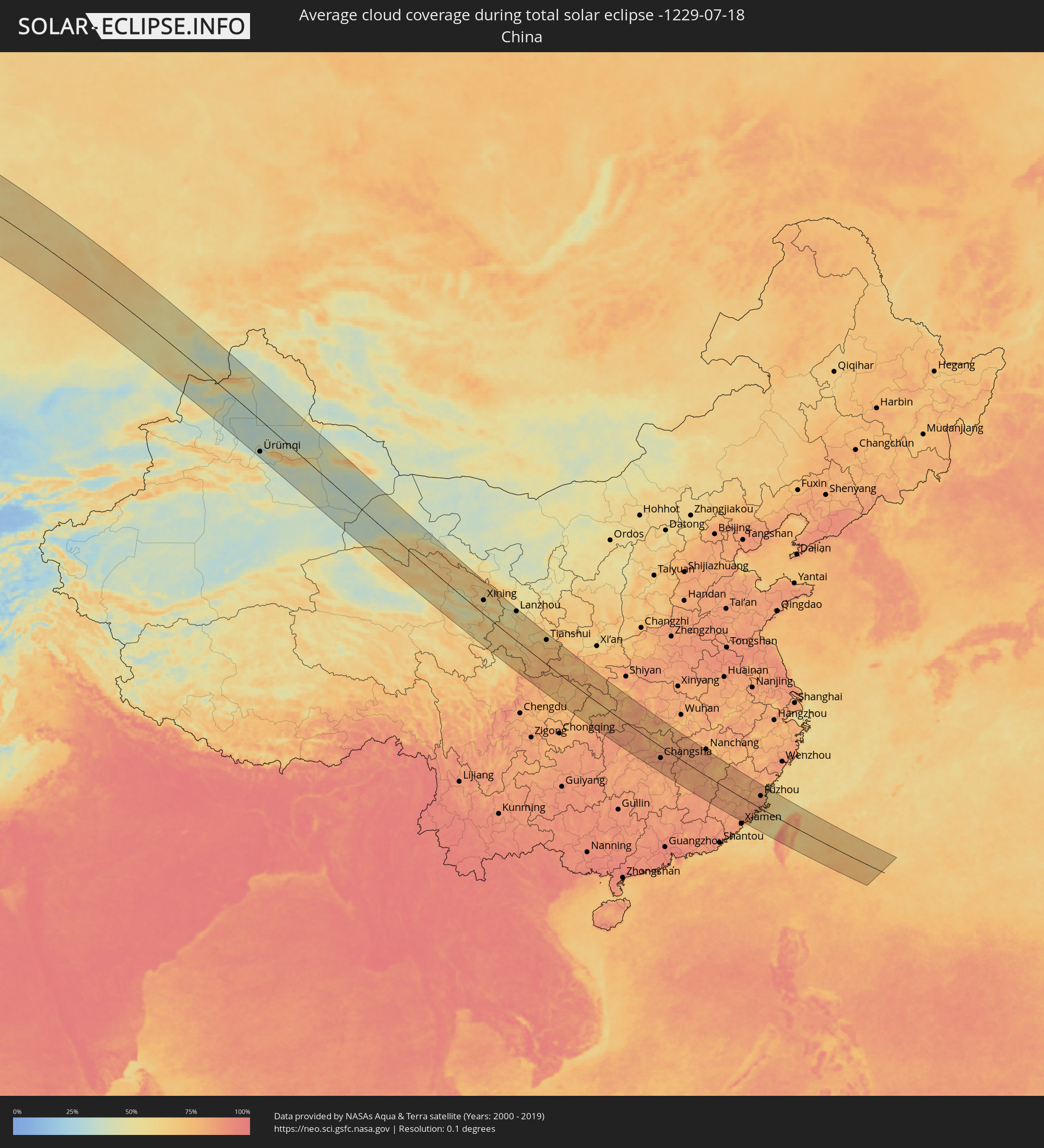 Volksrepublik China
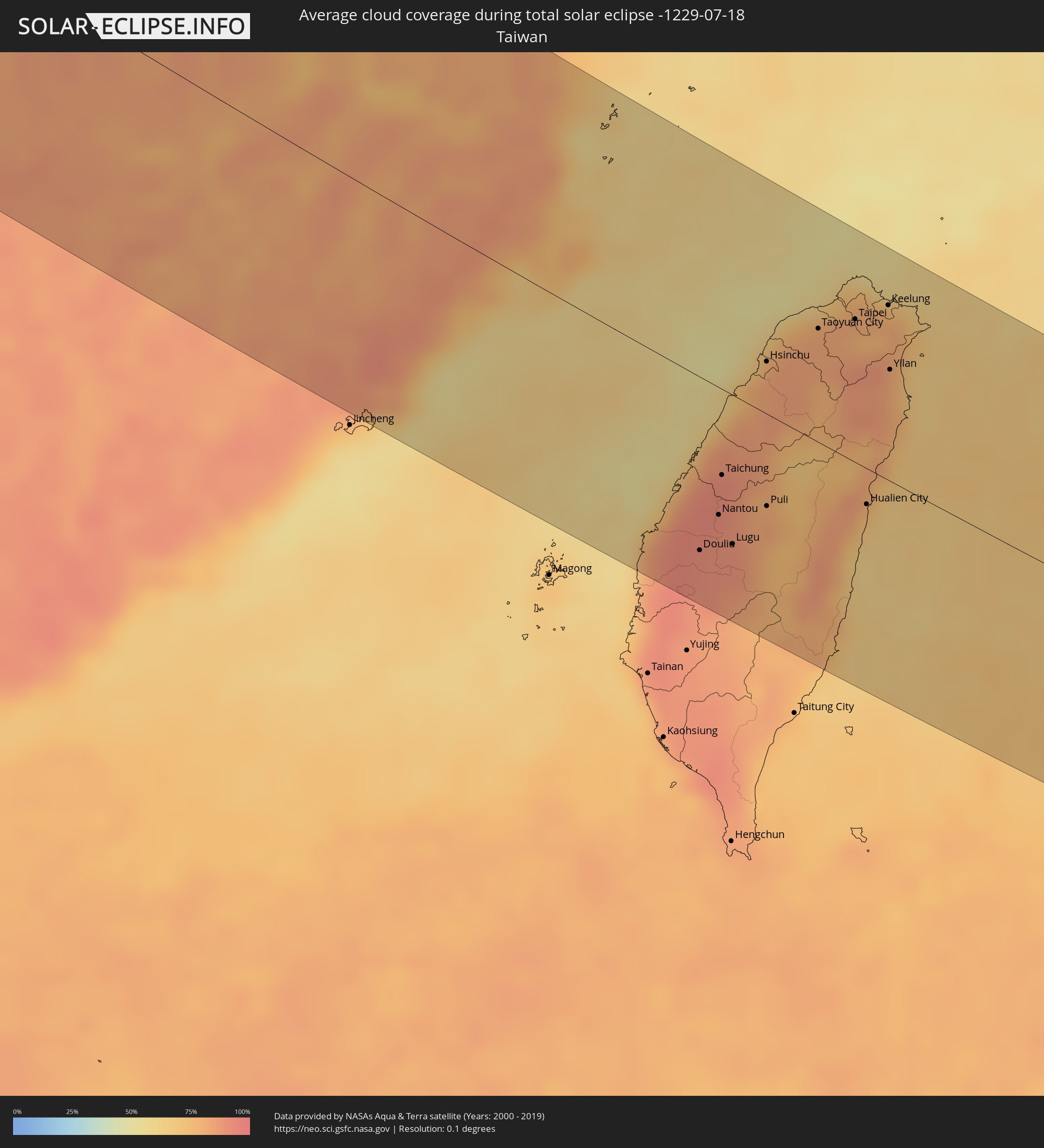 Taiwan
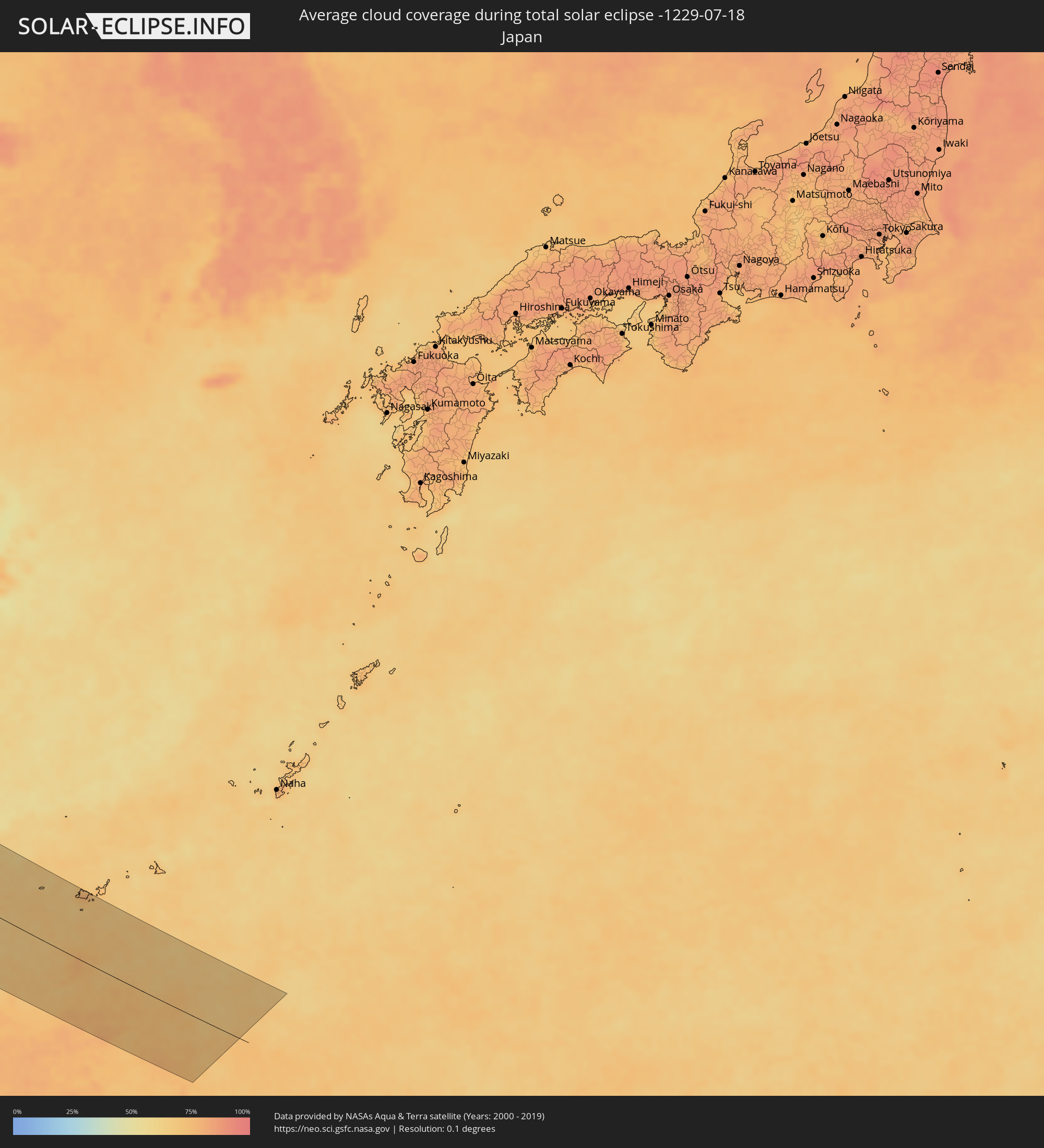 Japan
Japan
Orte im Finsternispfad
Die nachfolgene Tabelle zeigt Städte und Orte mit mehr als 5.000 Einwohnern, die sich im Finsternispfad befinden. Städte mit mehr als 100.000 Einwohnern sind dick gekennzeichnet. Mit einem Klick auf den Ort öffnet sich eine Detailkarte die die Lage des jeweiligen Ortes zusammen mit dem Verlauf der zentralen Finsternis präsentiert.
| Ort | Typ | Dauer der Verfinsterung | Ortszeit bei maximaler Verfinsterung | Entfernung zur Zentrallinie | Ø Bewölkung |
|
Westport, Connaught
|
total | - | 07:08:13 UTC-00:25 | 95 km | 84% |
|
Castlebar, Connaught
|
total | - | 07:08:22 UTC-00:25 | 96 km | 83% |
|
Ballina, Connaught
|
total | - | 07:08:47 UTC-00:25 | 74 km | 84% |
|
Sligo, Connaught
|
total | - | 07:09:14 UTC-00:25 | 78 km | 84% |
|
Letterkenny, Ulster
|
total | - | 07:10:27 UTC-00:25 | 32 km | 85% |
|
Buncrana, Ulster
|
total | - | 07:10:49 UTC-00:25 | 23 km | 83% |
|
Londonderry County Borough, Northern Ireland
|
total | - | 07:36:01 UTC+00:00 | 39 km | 84% |
|
Monaghan, Ulster
|
total | - | 07:09:45 UTC-00:25 | 124 km | 85% |
|
Craigavon, Northern Ireland
|
total | - | 07:35:36 UTC+00:00 | 121 km | 82% |
|
Belfast, Northern Ireland
|
total | - | 07:36:00 UTC+00:00 | 119 km | 83% |
|
Bangor, Northern Ireland
|
total | - | 07:36:11 UTC+00:00 | 119 km | 81% |
|
Greenock, Scotland
|
total | - | 07:38:23 UTC+00:00 | 17 km | 84% |
|
Ayr, Scotland
|
total | - | 07:37:46 UTC+00:00 | 66 km | 82% |
|
Kilmarnock, Scotland
|
total | - | 07:38:02 UTC+00:00 | 55 km | 83% |
|
Glasgow, Scotland
|
total | - | 07:38:29 UTC+00:00 | 35 km | 88% |
|
Inverness, Scotland
|
total | - | 07:40:46 UTC+00:00 | 128 km | 87% |
|
Hamilton, Scotland
|
total | - | 07:38:27 UTC+00:00 | 51 km | 86% |
|
Cumbernauld, Scotland
|
total | - | 07:38:43 UTC+00:00 | 36 km | 87% |
|
Stirling, Scotland
|
total | - | 07:38:59 UTC+00:00 | 18 km | 84% |
|
Livingston, Scotland
|
total | - | 07:38:52 UTC+00:00 | 51 km | 84% |
|
Dunfermline, Scotland
|
total | - | 07:39:08 UTC+00:00 | 37 km | 83% |
|
Perth, Scotland
|
total | - | 07:39:36 UTC+00:00 | 4 km | 86% |
|
Edinburgh, Scotland
|
total | - | 07:39:05 UTC+00:00 | 53 km | 84% |
|
Kirkcaldy, Scotland
|
total | - | 07:39:20 UTC+00:00 | 38 km | 84% |
|
Dundee, Scotland
|
total | - | 07:39:55 UTC+00:00 | 6 km | 85% |
|
Aberdeen, Scotland
|
total | - | 07:41:16 UTC+00:00 | 42 km | 87% |
|
Haugesund, Rogaland
|
total | - | 08:48:22 UTC+01:00 | 118 km | 75% |
|
Stavanger, Rogaland
|
total | - | 08:48:05 UTC+01:00 | 63 km | 75% |
|
Kristiansand, Vest-Agder
|
total | - | 08:48:31 UTC+01:00 | 66 km | 69% |
|
Arendal, Aust-Agder
|
total | - | 08:49:27 UTC+01:00 | 45 km | 66% |
|
Skien, Telemark
|
total | - | 08:50:57 UTC+01:00 | 25 km | 70% |
|
Kongsberg, Buskerud
|
total | - | 08:51:32 UTC+01:00 | 70 km | 77% |
|
Drammen, Buskerud
|
total | - | 08:52:01 UTC+01:00 | 69 km | 75% |
|
Sandefjord, Vestfold
|
total | - | 08:51:17 UTC+01:00 | 14 km | 66% |
|
Hønefoss, Buskerud
|
total | - | 08:52:34 UTC+01:00 | 114 km | 74% |
|
Tønsberg, Vestfold
|
total | - | 08:51:35 UTC+01:00 | 15 km | 69% |
|
Moss, Østfold
|
total | - | 08:51:58 UTC+01:00 | 31 km | 68% |
|
Oslo, Oslo
|
total | - | 08:52:36 UTC+01:00 | 79 km | 78% |
|
Ski, Akershus
|
total | - | 08:52:26 UTC+01:00 | 57 km | 73% |
|
Fredrikstad, Østfold
|
total | - | 08:51:55 UTC+01:00 | 4 km | 69% |
|
Lillestrøm, Akershus
|
total | - | 08:52:52 UTC+01:00 | 79 km | 78% |
|
Askim, Østfold
|
total | - | 08:52:31 UTC+01:00 | 39 km | 73% |
|
Jessheim, Akershus
|
total | - | 08:53:11 UTC+01:00 | 97 km | 74% |
|
Halden, Østfold
|
total | - | 08:52:08 UTC+01:00 | 19 km | 68% |
|
Uddevalla, Västra Götaland
|
total | - | 08:51:39 UTC+01:00 | 107 km | 68% |
|
Kongsvinger, Hedmark
|
total | - | 08:53:50 UTC+01:00 | 91 km | 77% |
|
Trollhättan, Västra Götaland
|
total | - | 08:51:50 UTC+01:00 | 120 km | 68% |
|
Karlstad, Värmland
|
total | - | 08:54:02 UTC+01:00 | 18 km | 67% |
|
Skövde, Västra Götaland
|
total | - | 08:53:12 UTC+01:00 | 129 km | 74% |
|
Karlskoga, Örebro
|
total | - | 08:54:47 UTC+01:00 | 37 km | 73% |
|
Motala, Östergötland
|
total | - | 08:54:20 UTC+01:00 | 128 km | 66% |
|
Örebro, Örebro
|
total | - | 08:55:16 UTC+01:00 | 50 km | 75% |
|
Borlänge, Dalarna
|
total | - | 08:56:46 UTC+01:00 | 80 km | 77% |
|
Falun, Dalarna
|
total | - | 08:57:02 UTC+01:00 | 90 km | 78% |
|
Norrköping, Östergötland
|
total | - | 08:55:22 UTC+01:00 | 136 km | 72% |
|
Eskilstuna, Södermanland
|
total | - | 08:56:27 UTC+01:00 | 56 km | 73% |
|
Västerås, Västmanland
|
total | - | 08:56:44 UTC+01:00 | 28 km | 70% |
|
Nyköping, Södermanland
|
total | - | 08:56:14 UTC+01:00 | 127 km | 70% |
|
Gävle, Gävleborg
|
total | - | 08:58:19 UTC+01:00 | 82 km | 70% |
|
Södertälje, Stockholm
|
total | - | 08:57:13 UTC+01:00 | 86 km | 71% |
|
Uppsala, Uppsala
|
total | - | 08:57:54 UTC+01:00 | 14 km | 75% |
|
Upplands Väsby, Stockholm
|
total | - | 08:57:47 UTC+01:00 | 55 km | 72% |
|
Stockholm, Stockholm
|
total | - | 08:57:44 UTC+01:00 | 75 km | 74% |
|
Haninge, Stockholm
|
total | - | 08:57:38 UTC+01:00 | 94 km | 70% |
|
Mariehamn, Mariehamns stad
|
total | - | 09:39:55 UTC+01:39 | 9 km | 65% |
|
Rauma, Satakunta
|
total | - | 09:42:13 UTC+01:39 | 95 km | 64% |
|
Pori, Satakunta
|
total | - | 09:42:46 UTC+01:39 | 132 km | 65% |
|
Turku, Southwest Finland
|
total | - | 09:42:18 UTC+01:39 | 18 km | 68% |
|
Tampere, Pirkanmaa
|
total | - | 09:44:31 UTC+01:39 | 121 km | 71% |
|
Lohja, Uusimaa
|
total | - | 09:43:47 UTC+01:39 | 19 km | 63% |
|
Keila, Harjumaa
|
total | - | 09:42:34 UTC+01:39 | 126 km | 63% |
|
Hämeenlinna, Häme
|
total | - | 09:44:44 UTC+01:39 | 62 km | 68% |
|
Saue, Harjumaa
|
total | - | 09:42:43 UTC+01:39 | 124 km | 65% |
|
Espoo, Uusimaa
|
total | - | 09:44:18 UTC+01:39 | 27 km | 69% |
|
Tallinn, Harjumaa
|
total | - | 09:43:00 UTC+01:39 | 112 km | 63% |
|
Nurmijärvi, Uusimaa
|
total | - | 09:44:39 UTC+01:39 | 11 km | 67% |
|
Hyvinge, Uusimaa
|
total | - | 09:44:50 UTC+01:39 | 21 km | 68% |
|
Helsinki, Uusimaa
|
total | - | 09:44:33 UTC+01:39 | 32 km | 72% |
|
Maardu, Harjumaa
|
total | - | 09:43:18 UTC+01:39 | 109 km | 60% |
|
Vantaa, Uusimaa
|
total | - | 09:44:44 UTC+01:39 | 18 km | 67% |
|
Järvenpää, Uusimaa
|
total | - | 09:44:55 UTC+01:39 | 5 km | 67% |
|
Lahti, Päijänne Tavastia
|
total | - | 09:45:50 UTC+01:39 | 57 km | 69% |
|
Porvoo, Uusimaa
|
total | - | 09:45:24 UTC+01:39 | 13 km | 64% |
|
Tapa, Lääne-Virumaa
|
total | - | 09:44:04 UTC+01:39 | 137 km | 66% |
|
Rakvere, Lääne-Virumaa
|
total | - | 09:44:31 UTC+01:39 | 129 km | 67% |
|
Kouvola, Kymenlaakso
|
total | - | 09:46:44 UTC+01:39 | 42 km | 68% |
|
Kotka, Kymenlaakso
|
total | - | 09:46:40 UTC+01:39 | 8 km | 72% |
|
Kiviõli, Ida-Virumaa
|
total | - | 09:45:09 UTC+01:39 | 130 km | 66% |
|
Mikkeli, Southern Savonia
|
total | - | 09:47:49 UTC+01:39 | 129 km | 72% |
|
Kohtla-Järve, Ida-Virumaa
|
total | - | 09:45:29 UTC+01:39 | 126 km | 66% |
|
Jõhvi, Ida-Virumaa
|
total | - | 09:45:36 UTC+01:39 | 131 km | 67% |
|
Sillamäe, Ida-Virumaa
|
total | - | 09:45:59 UTC+01:39 | 127 km | 67% |
|
Lappeenranta, South Karelia
|
total | - | 09:48:16 UTC+01:39 | 58 km | 72% |
|
Narva, Ida-Virumaa
|
total | - | 09:46:24 UTC+01:39 | 130 km | 68% |
|
Imatra, South Karelia
|
total | - | 09:48:53 UTC+01:39 | 70 km | 72% |
|
Vyborg, Leningradskaya Oblast'
|
total | - | 10:39:04 UTC+02:30 | 22 km | 69% |
|
Gatchina, Leningradskaya Oblast'
|
total | - | 10:39:49 UTC+02:30 | 110 km | 73% |
|
Saint Petersburg, St.-Petersburg
|
total | - | 10:40:12 UTC+02:30 | 71 km | 78% |
|
Kolpino, St.-Petersburg
|
total | - | 10:40:23 UTC+02:30 | 91 km | 75% |
|
Cherepovets, Vologda
|
total | - | 10:48:11 UTC+02:30 | 137 km | 71% |
|
Vologda, Vologda
|
total | - | 10:50:28 UTC+02:30 | 114 km | 73% |
|
Kirov, Kirov
|
total | - | 11:02:01 UTC+02:30 | 64 km | 63% |
|
Kirovo-Chepetsk, Kirov
|
total | - | 11:02:29 UTC+02:30 | 62 km | 61% |
|
Glazov, Udmurtiya
|
total | - | 11:55:51 UTC+03:20 | 60 km | 59% |
|
Perm, Perm
|
total | - | 12:42:23 UTC+04:02 | 16 km | 64% |
|
Pervoural’sk, Sverdlovsk
|
total | - | 12:47:36 UTC+04:02 | 26 km | 69% |
|
Nizhniy Tagil, Sverdlovsk
|
total | - | 12:46:44 UTC+04:02 | 78 km | 66% |
|
Novoural’sk, Sverdlovsk
|
total | - | 12:47:28 UTC+04:02 | 13 km | 67% |
|
Yekaterinburg, Sverdlovsk
|
total | - | 12:48:26 UTC+04:02 | 19 km | 70% |
|
Ozersk, Chelyabinsk
|
total | - | 12:49:35 UTC+04:02 | 121 km | 63% |
|
Asbest, Sverdlovsk
|
total | - | 12:49:16 UTC+04:02 | 29 km | 67% |
|
Kamensk-Ural’skiy, Sverdlovsk
|
total | - | 12:50:24 UTC+04:02 | 22 km | 61% |
|
Shadrinsk, Kurgan
|
total | - | 12:52:43 UTC+04:02 | 14 km | 58% |
|
Kurgan, Kurgan
|
total | - | 12:55:22 UTC+04:02 | 18 km | 64% |
|
Petropavl, Soltüstik Qazaqstan
|
total | - | 13:19:40 UTC+04:21 | 53 km | 56% |
|
Kokshetau, Aqmola
|
total | - | 13:22:01 UTC+04:21 | 91 km | 58% |
|
Taiynsha, Soltüstik Qazaqstan
|
total | - | 13:21:41 UTC+04:21 | 25 km | 57% |
|
Shchuchinsk, Aqmola
|
total | - | 13:23:23 UTC+04:21 | 95 km | 59% |
|
Makinsk, Aqmola
|
total | - | 13:24:03 UTC+04:21 | 115 km | 58% |
|
Bulayevo, Soltüstik Qazaqstan
|
total | - | 13:21:00 UTC+04:21 | 99 km | 55% |
|
Stepnogorsk, Aqmola
|
total | - | 13:26:05 UTC+04:21 | 87 km | 64% |
|
Yereymentau, Aqmola
|
total | - | 13:28:29 UTC+04:21 | 107 km | 63% |
|
Ekibastuz, Pavlodar
|
total | - | 13:30:40 UTC+04:21 | 12 km | 62% |
|
Irtyshsk, Pavlodar
|
total | - | 13:28:22 UTC+04:21 | 142 km | 56% |
|
Aksu, Pavlodar
|
total | - | 13:31:47 UTC+04:21 | 87 km | 61% |
|
Pavlodar, Pavlodar
|
total | - | 13:31:27 UTC+04:21 | 108 km | 61% |
|
Kūrchatov, Pavlodar
|
total | - | 13:35:22 UTC+04:21 | 44 km | 61% |
|
Semey, East Kazakhstan
|
total | - | 13:37:31 UTC+04:21 | 87 km | 56% |
|
Ayagoz, East Kazakhstan
|
total | - | 13:41:43 UTC+04:21 | 119 km | 47% |
|
Shar, East Kazakhstan
|
total | - | 13:39:36 UTC+04:21 | 51 km | 51% |
|
Georgīevka, East Kazakhstan
|
total | - | 13:40:30 UTC+04:21 | 52 km | 51% |
|
Urzhar, East Kazakhstan
|
total | - | 13:44:17 UTC+04:21 | 140 km | 43% |
|
Zaysan, East Kazakhstan
|
total | - | 13:46:27 UTC+04:21 | 51 km | 45% |
|
Ürümqi, Xinjiang Uyghur Autonomous Region
|
total | - | 17:33:01 UTC+08:00 | 121 km | 37% |
|
Turpan, Xinjiang Uyghur Autonomous Region
|
total | - | 17:35:38 UTC+08:00 | 109 km | 41% |
|
Xining, Qinghai
|
total | - | 17:52:24 UTC+08:00 | 65 km | 52% |
|
Lanzhou, Gansu
|
total | - | 17:53:50 UTC+08:00 | 132 km | 52% |
|
Tianshui, Gansu
|
total | - | 17:56:28 UTC+08:00 | 113 km | 66% |
|
Guangyuan, Sichuan
|
total | - | 17:59:40 UTC+08:00 | 71 km | 75% |
|
Yichang, Hubei
|
total | - | 18:02:27 UTC+08:00 | 80 km | 86% |
|
Changde, Hunan
|
total | - | 18:04:42 UTC+08:00 | 51 km | 86% |
|
Shashi, Hubei
|
total | - | 18:02:59 UTC+08:00 | 98 km | 81% |
|
Xiangtan, Hunan
|
total | - | 18:06:11 UTC+08:00 | 96 km | 84% |
|
Changsha, Hunan
|
total | - | 18:05:43 UTC+08:00 | 64 km | 86% |
|
Yueyang, Hunan
|
total | - | 18:04:11 UTC+08:00 | 62 km | 78% |
|
Zhuzhou, Hunan
|
total | - | 18:06:11 UTC+08:00 | 85 km | 83% |
|
Guankou, Hunan
|
total | - | 18:05:43 UTC+08:00 | 38 km | 85% |
|
Pingxiang, Jiangxi
|
total | - | 18:06:23 UTC+08:00 | 71 km | 84% |
|
Ji’an, Jiangxi
|
total | - | 18:06:53 UTC+08:00 | 60 km | 82% |
|
Sanming, Fujian
|
total | - | 18:07:29 UTC+08:00 | 13 km | 80% |
|
Putian, Fujian
|
total | - | 18:08:08 UTC+08:00 | 6 km | 85% |
|
Fuzhou, Fujian
|
total | - | 18:07:20 UTC+08:00 | 69 km | 84% |
|
Douliu, Taiwan
|
total | - | 18:09:41 UTC+08:00 | 98 km | 91% |
|
Nantou, Taiwan
|
total | - | 18:09:25 UTC+08:00 | 72 km | 89% |
|
Taichung, Taiwan
|
total | - | 18:09:10 UTC+08:00 | 49 km | 91% |
|
Zhongxing New Village, Taiwan
|
total | - | 18:09:22 UTC+08:00 | 67 km | 91% |
|
Lugu, Taiwan
|
total | - | 18:09:35 UTC+08:00 | 86 km | 88% |
|
Hsinchu, Taiwan
|
total | - | 18:08:21 UTC+08:00 | 36 km | 81% |
|
Puli, Taiwan
|
total | - | 18:09:17 UTC+08:00 | 58 km | 80% |
|
Daxi, Taiwan
|
total | - | 18:08:10 UTC+08:00 | 53 km | 82% |
|
Taoyuan City, Taiwan
|
total | - | 18:08:02 UTC+08:00 | 64 km | 82% |
|
Banqiao, Taipei
|
total | - | 18:07:58 UTC+08:00 | 75 km | 80% |
|
Taipei, Taipei
|
total | - | 18:07:55 UTC+08:00 | 83 km | 80% |
|
Hualien City, Taiwan
|
total | - | 18:09:04 UTC+08:00 | 31 km | 75% |
|
Keelung, Taiwan
|
total | - | 18:07:46 UTC+08:00 | 102 km | 79% |
|
Yilan, Taiwan
|
total | - | 18:08:10 UTC+08:00 | 63 km | 78% |