Totale Sonnenfinsternis vom 14.03.-1231
| Wochentag: | Donnerstag |
| Maximale Dauer der Verfinsterung: | 04m20s |
| Maximale Breite des Finsternispfades: | 256 km |
| Saroszyklus: | 39 |
| Bedeckungsgrad: | 100% |
| Magnitude: | 1.0564 |
| Gamma: | 0.7022 |
Wo kann man die Sonnenfinsternis vom 14.03.-1231 sehen?
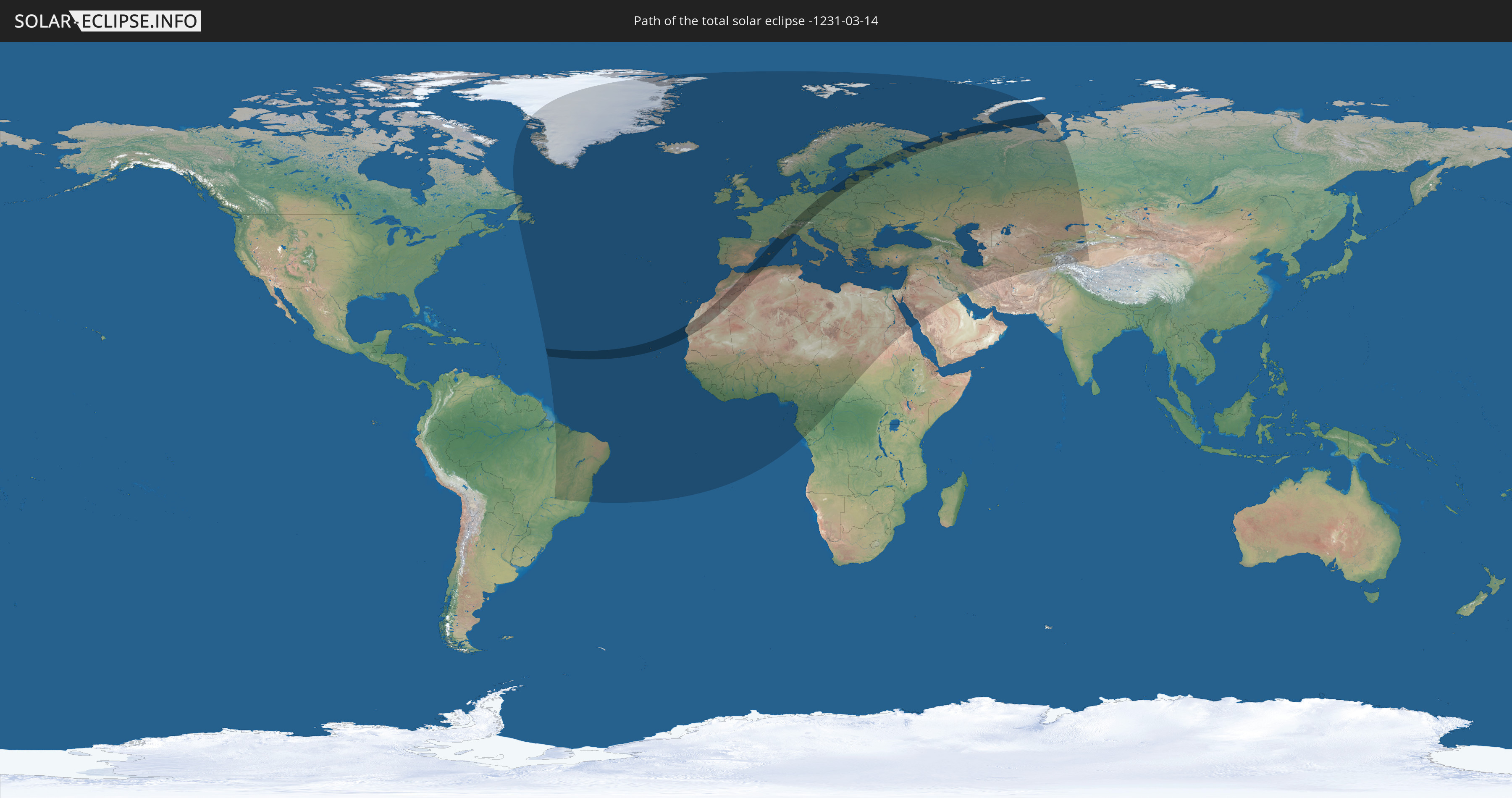
Die Sonnenfinsternis am 14.03.-1231 kann man in 107 Ländern als partielle Sonnenfinsternis beobachten.
Der Finsternispfad verläuft durch 19 Länder. Nur in diesen Ländern ist sie als totale Sonnenfinsternis zu sehen.
In den folgenden Ländern ist die Sonnenfinsternis total zu sehen
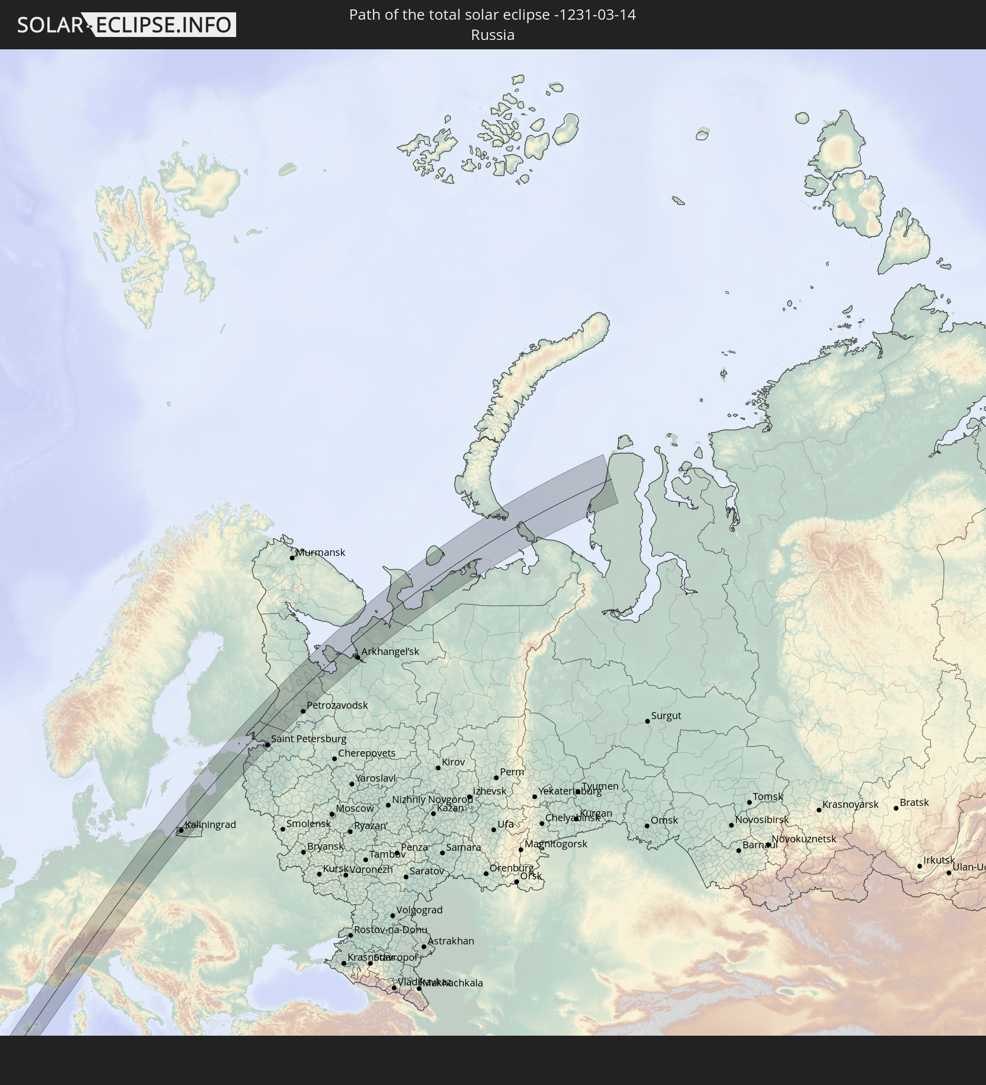 Russland
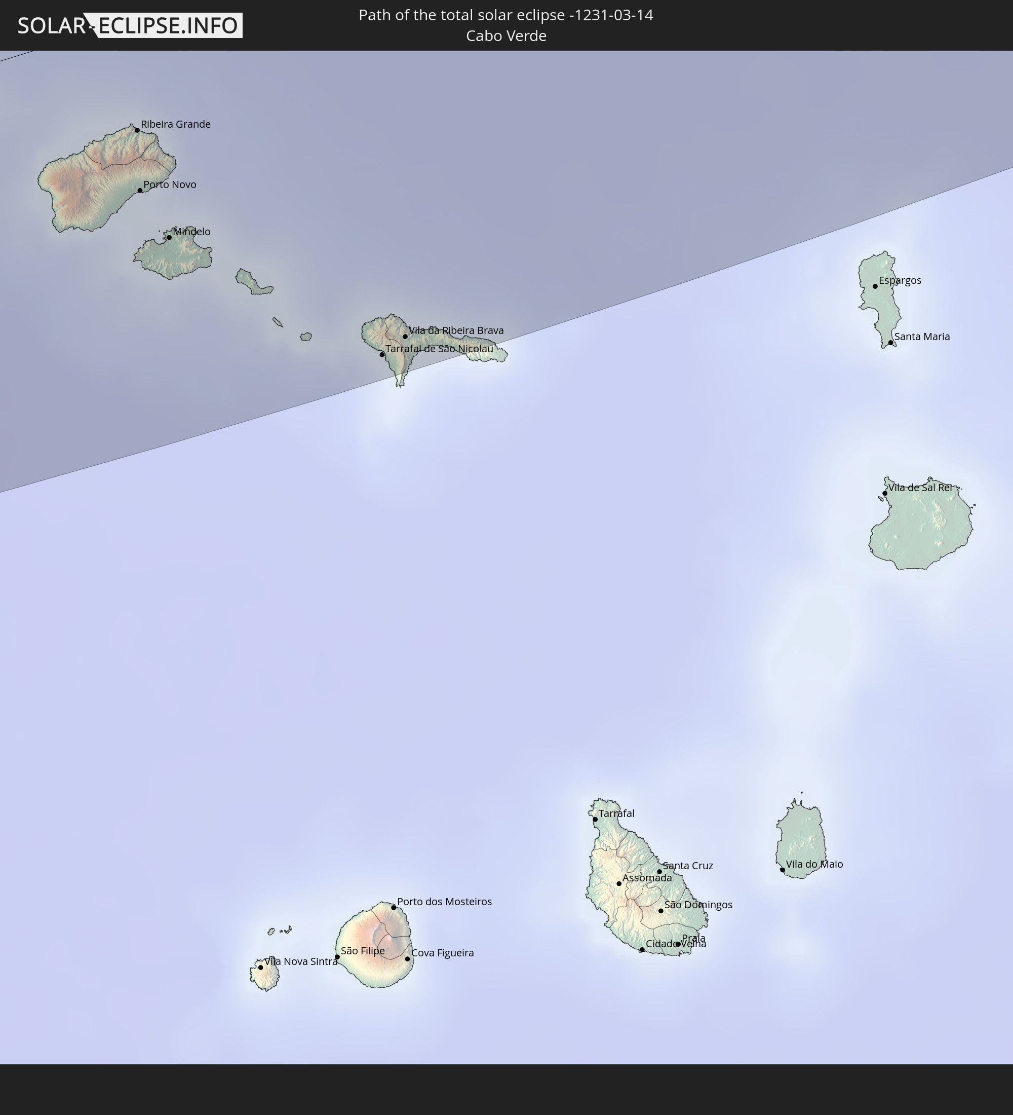 Kap Verde
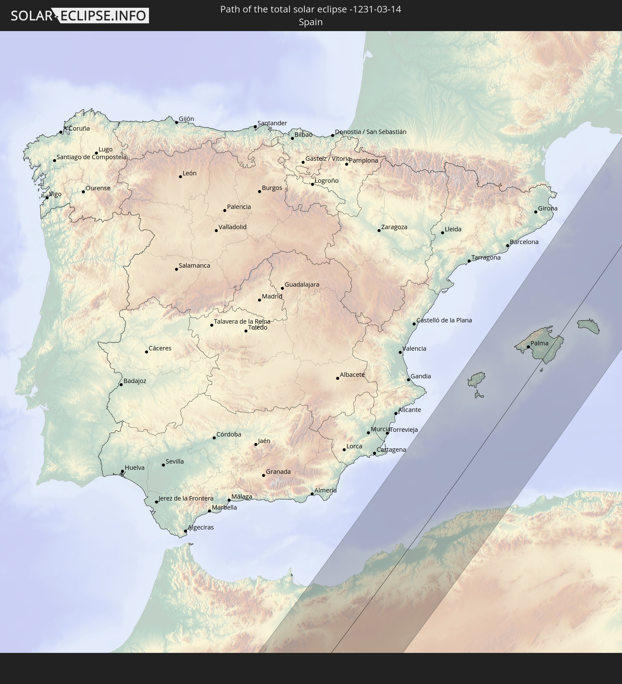 Spanien
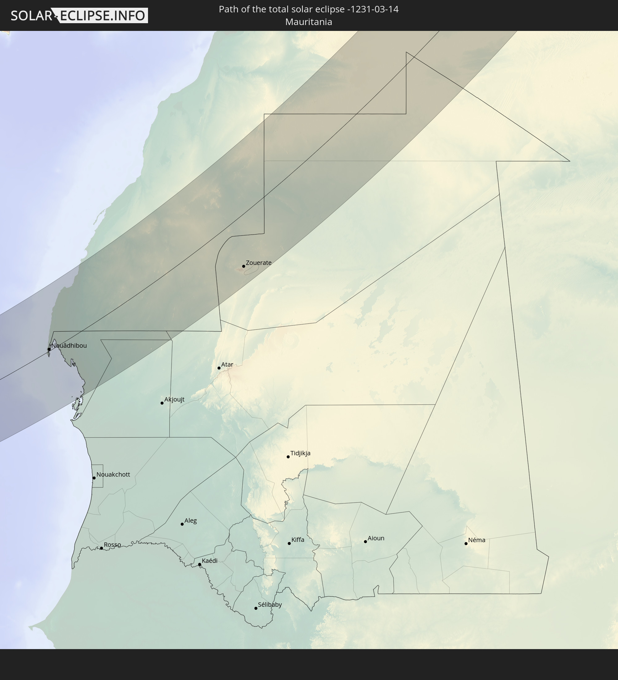 Mauretanien
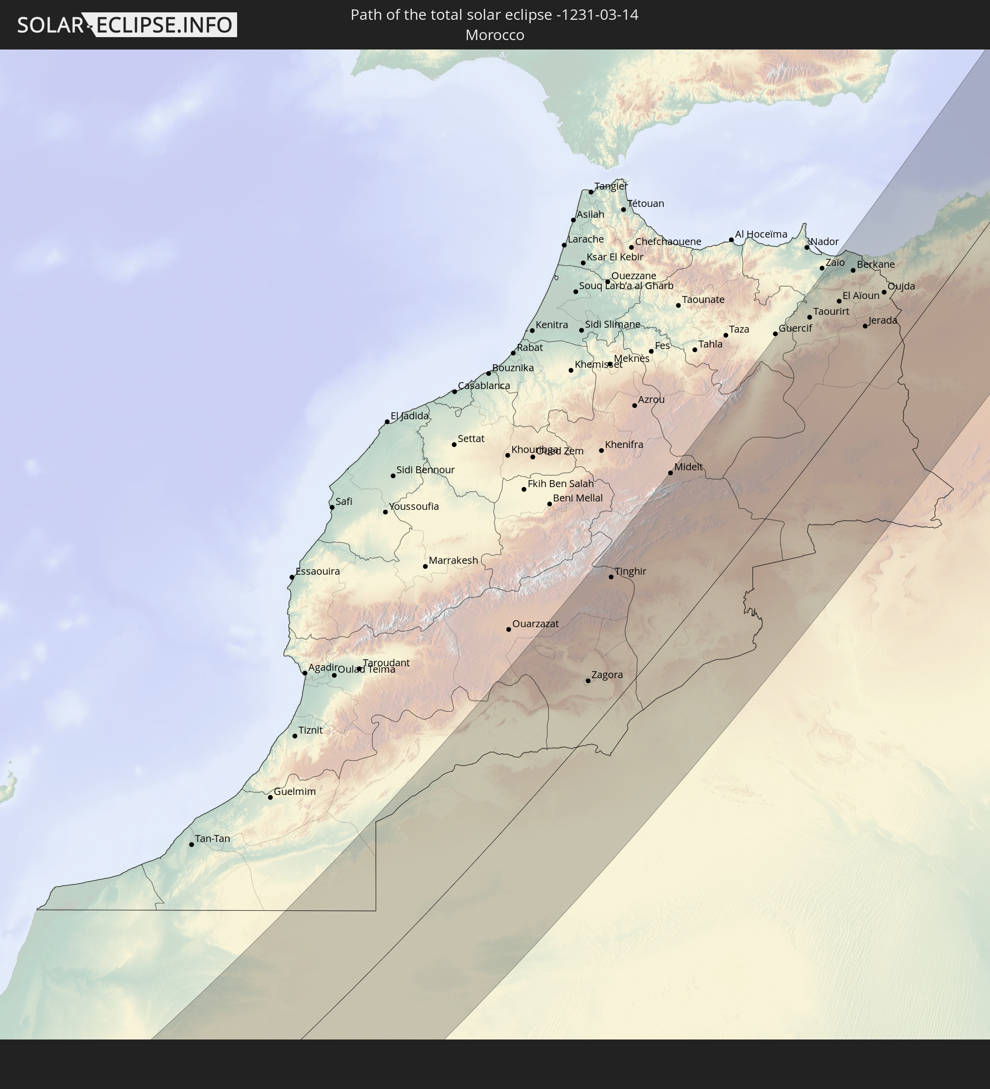 Marokko
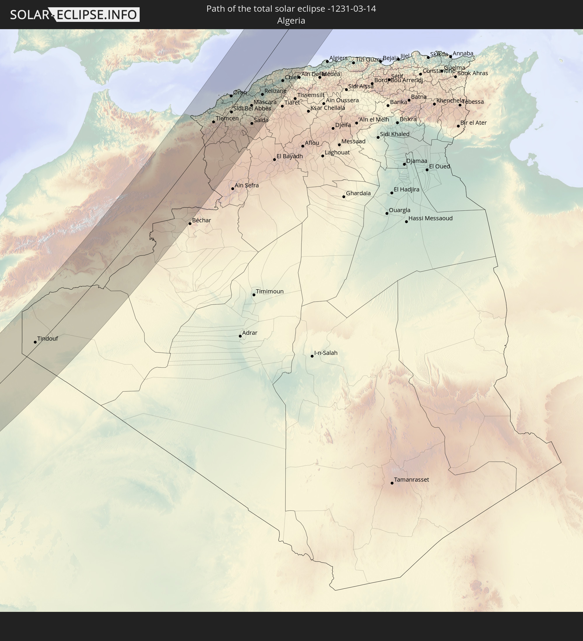 Algerien
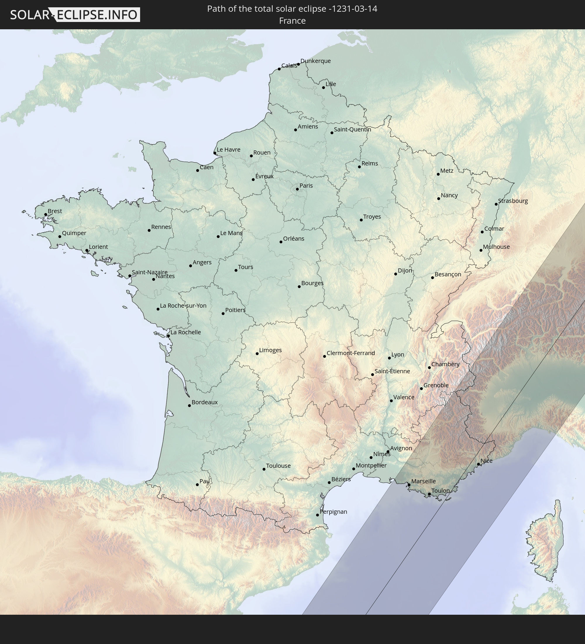 Frankreich
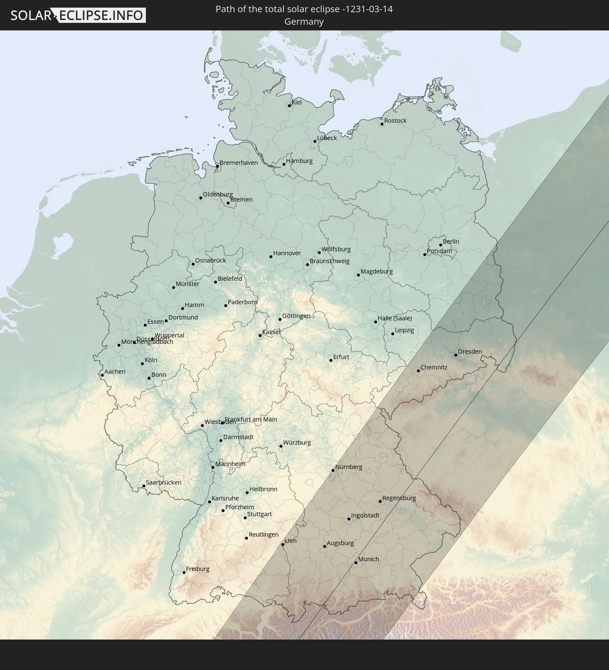 Deutschland
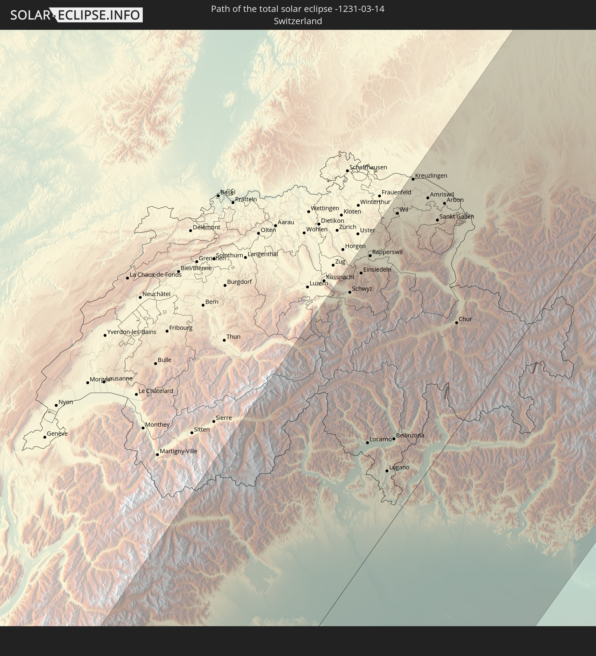 Schweiz
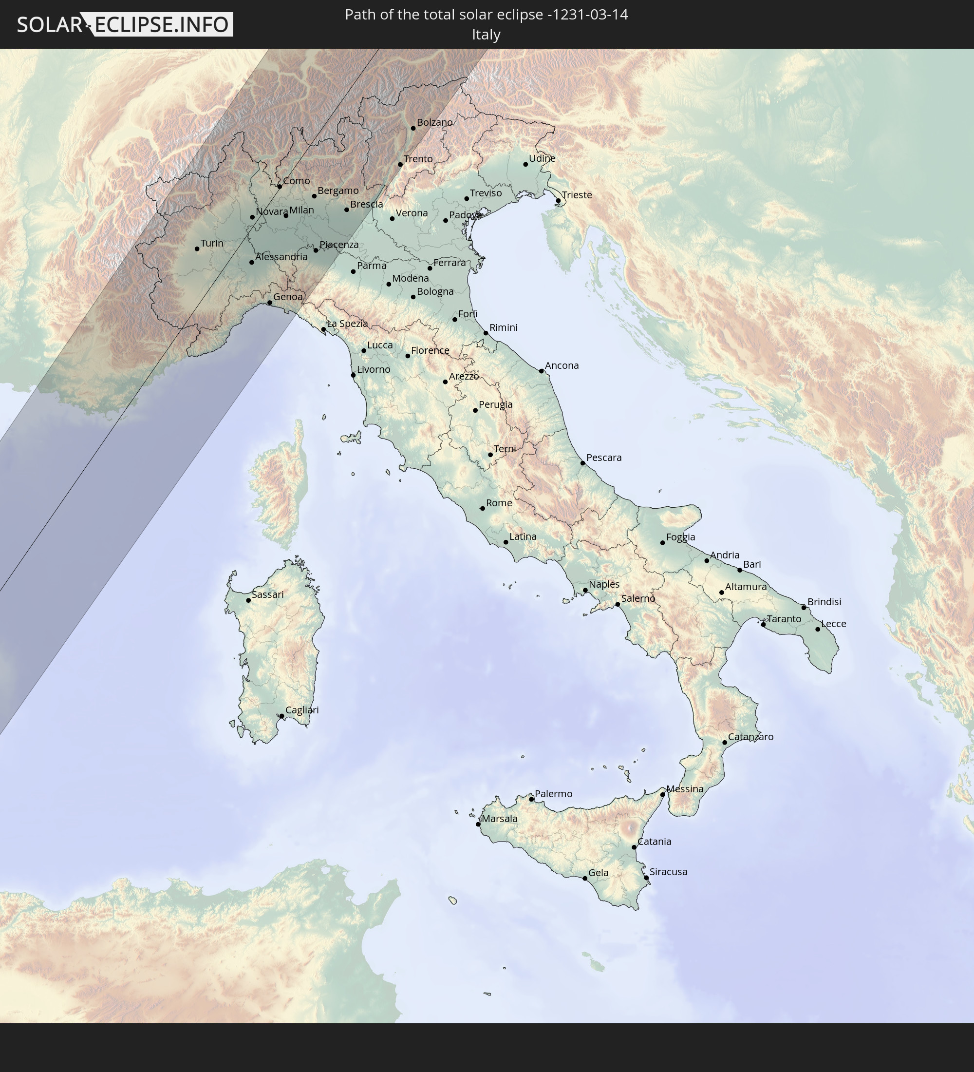 Italien
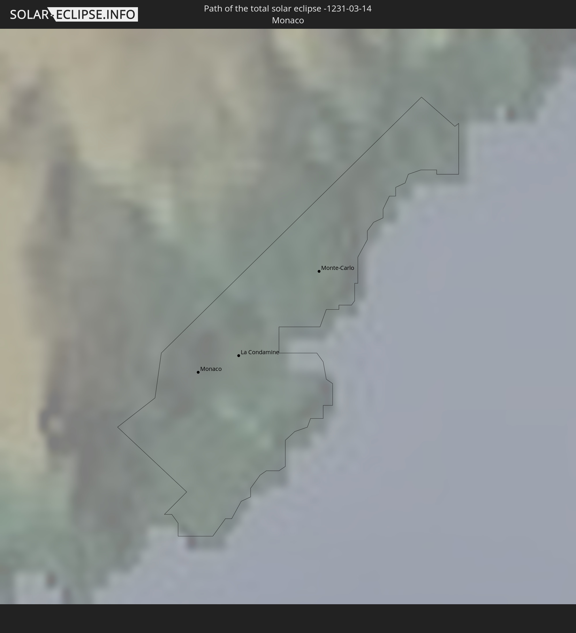 Monaco
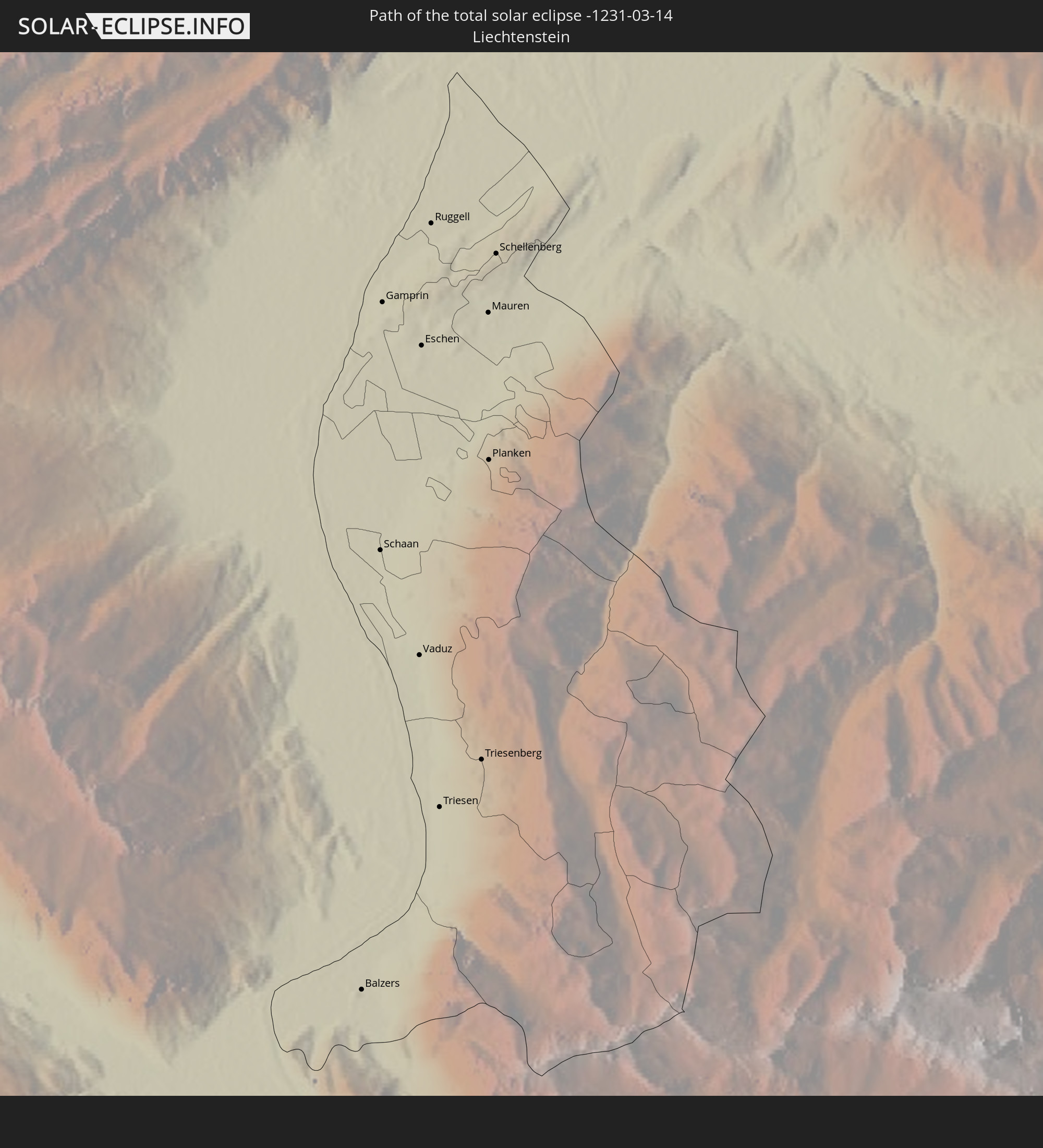 Liechtenstein
 Österreich
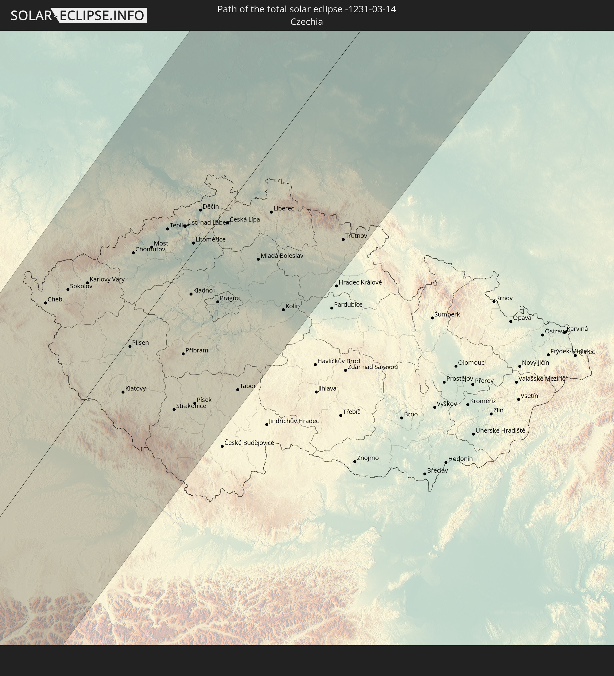 Tschechien
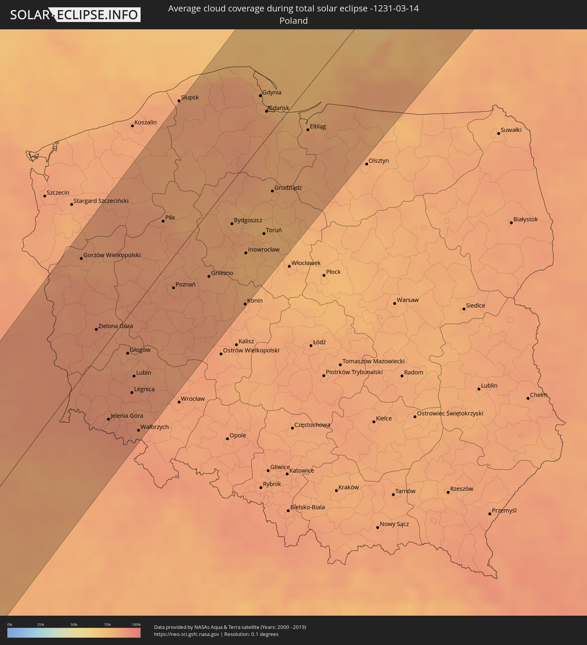
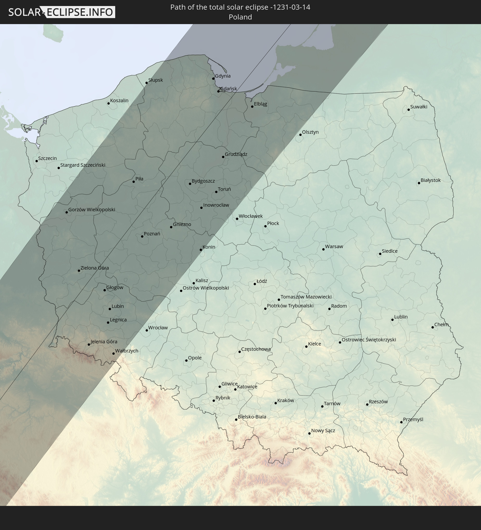 Polen
Polen
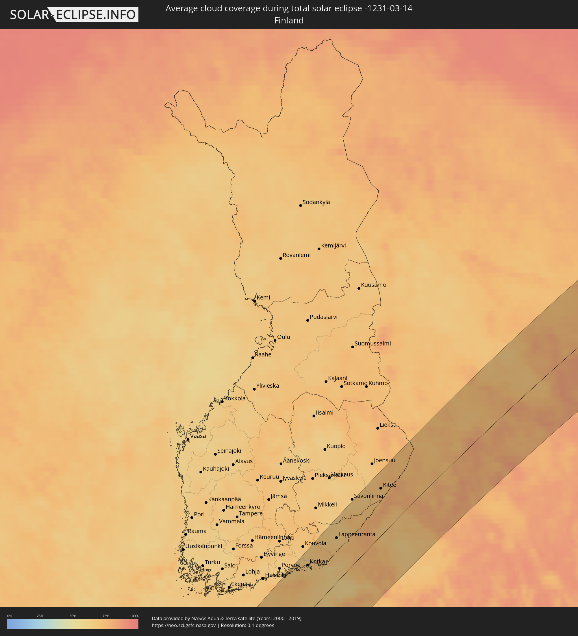
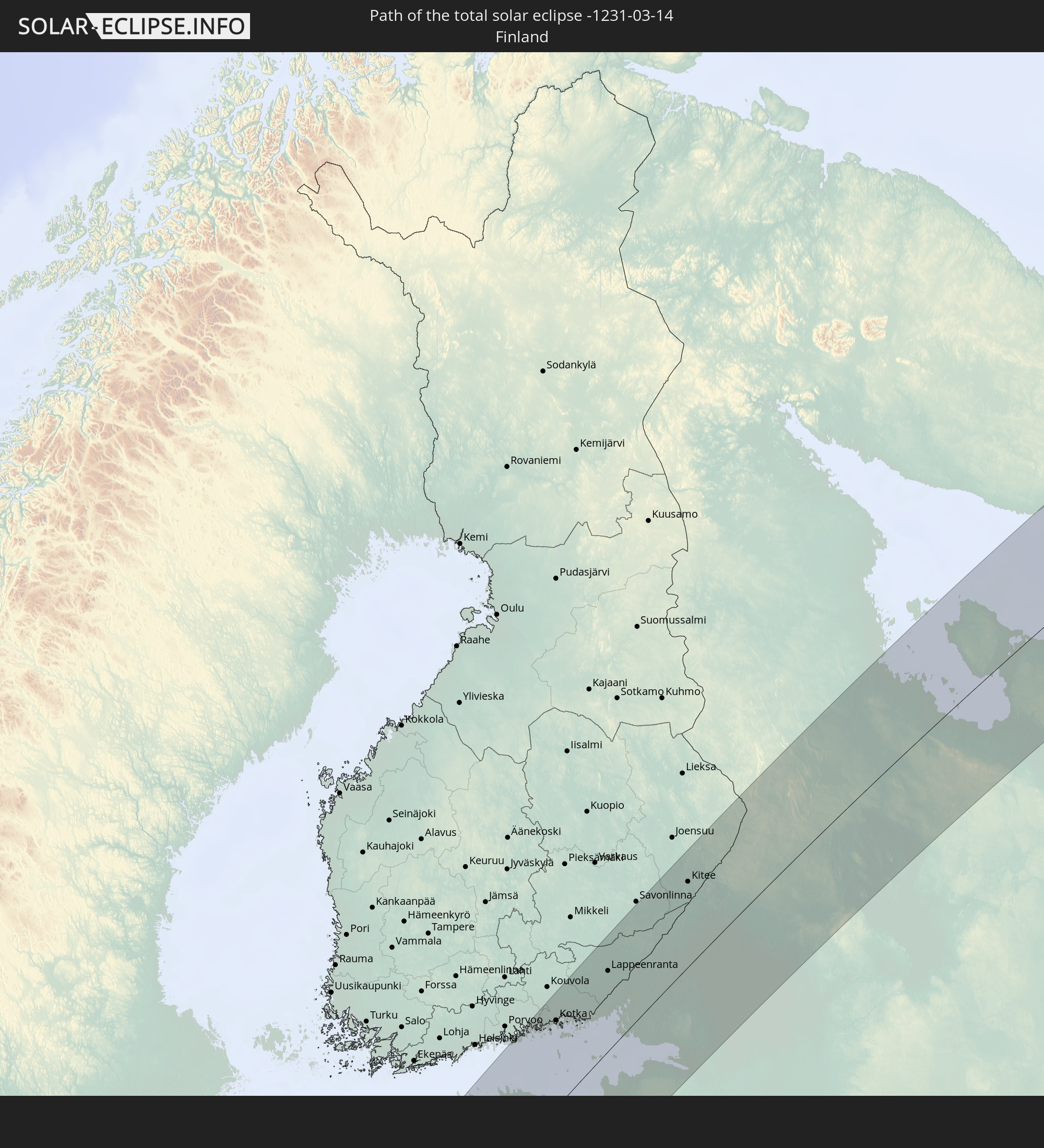 Finnland
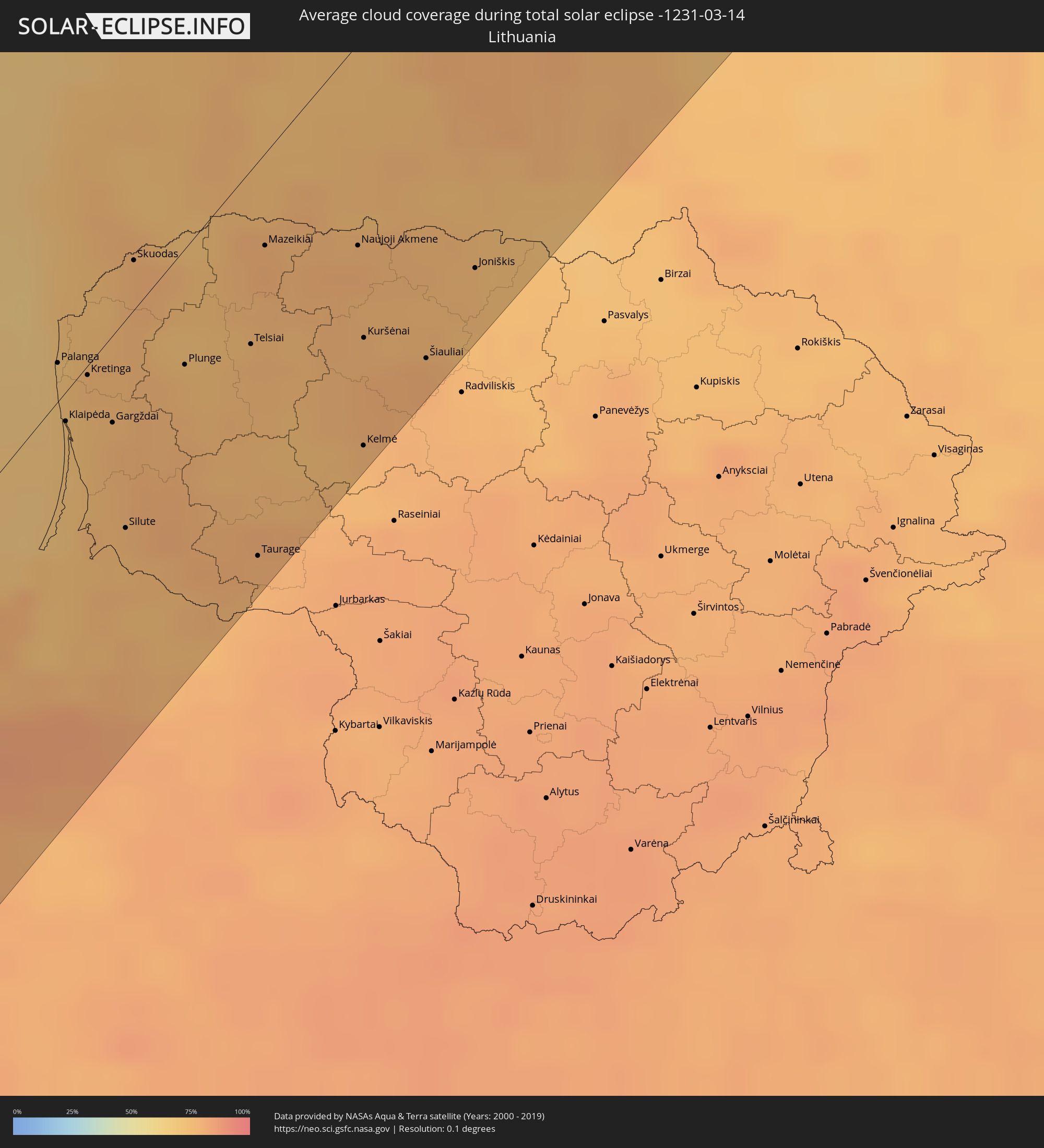
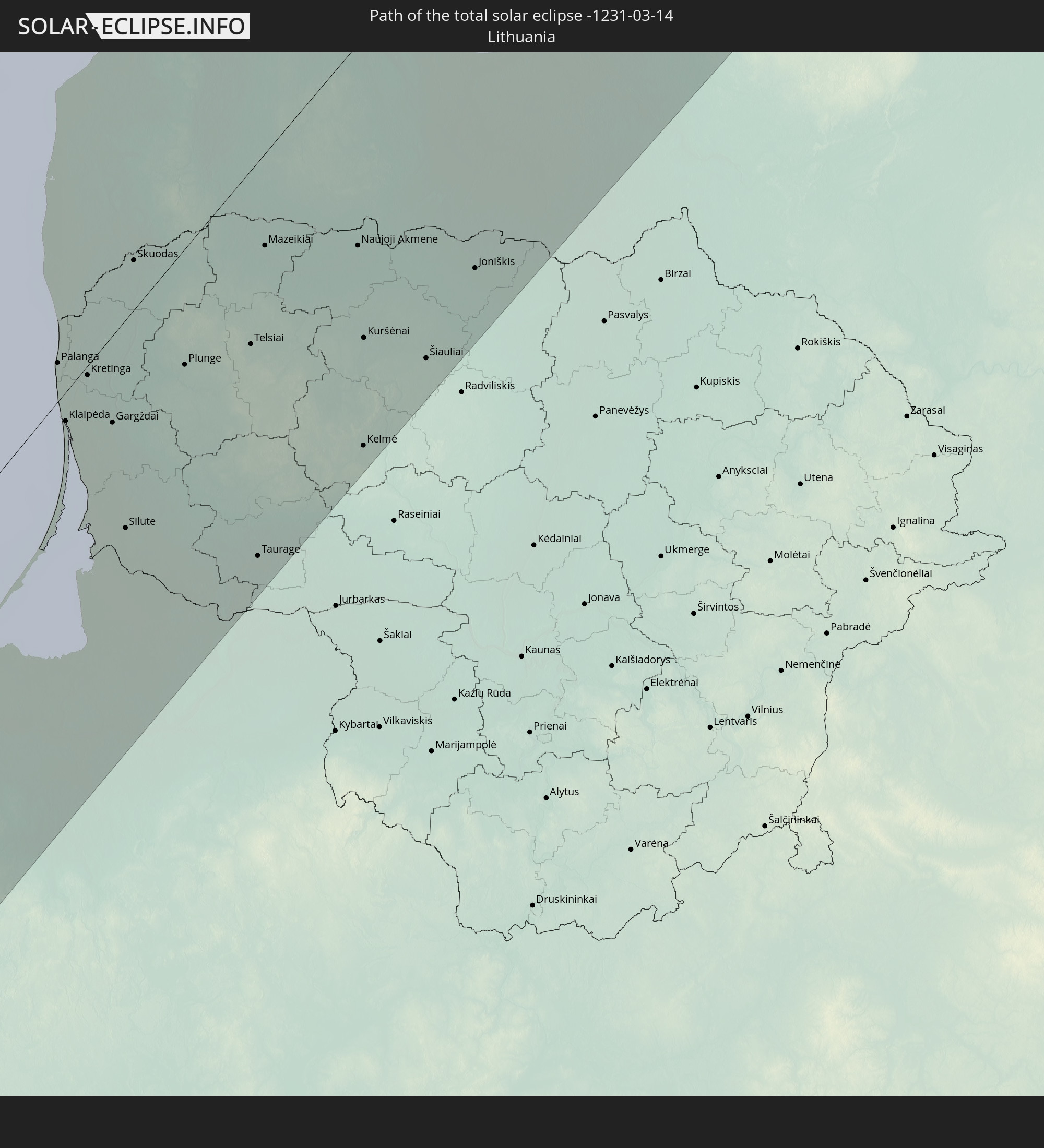 Litauen
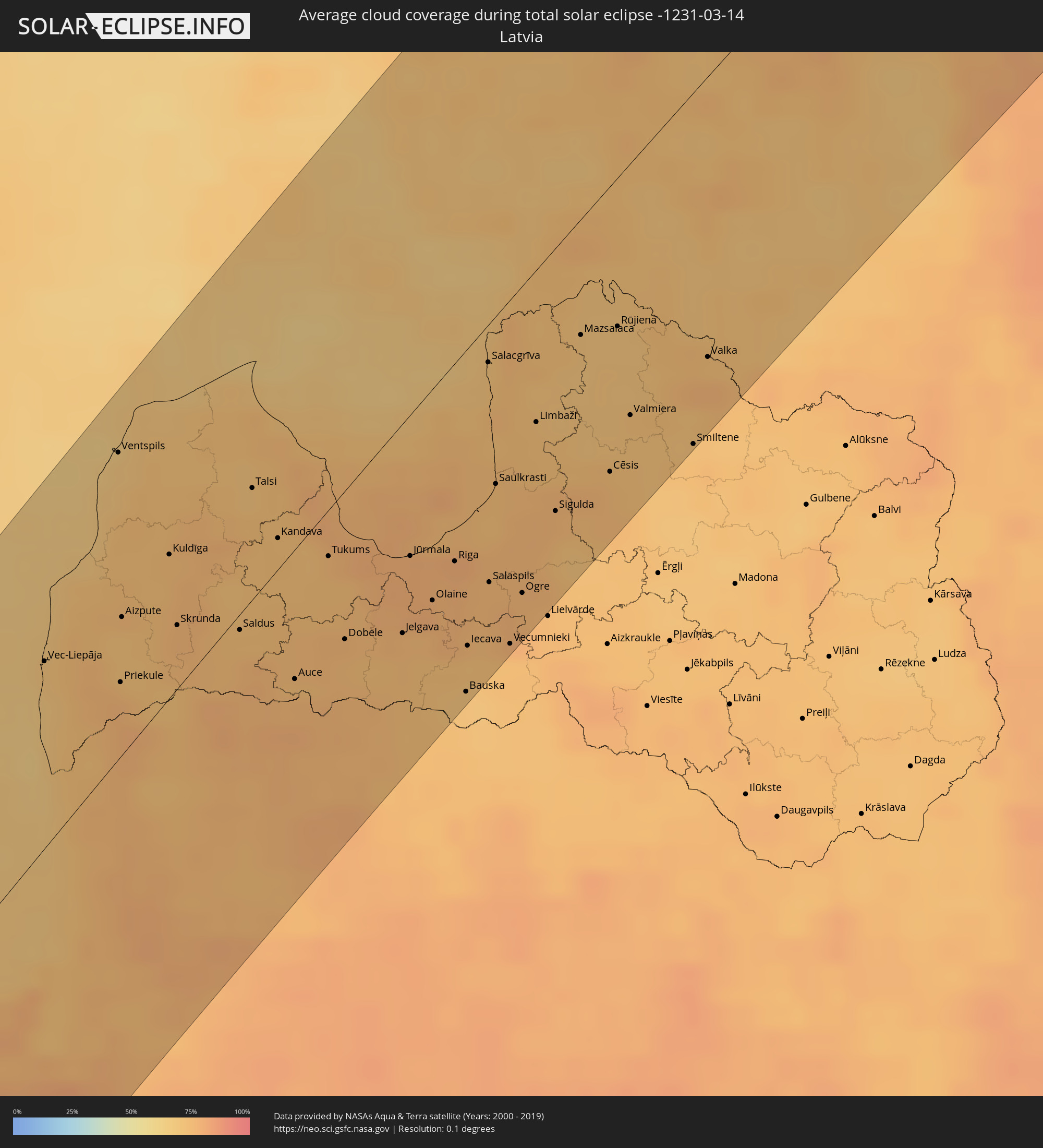
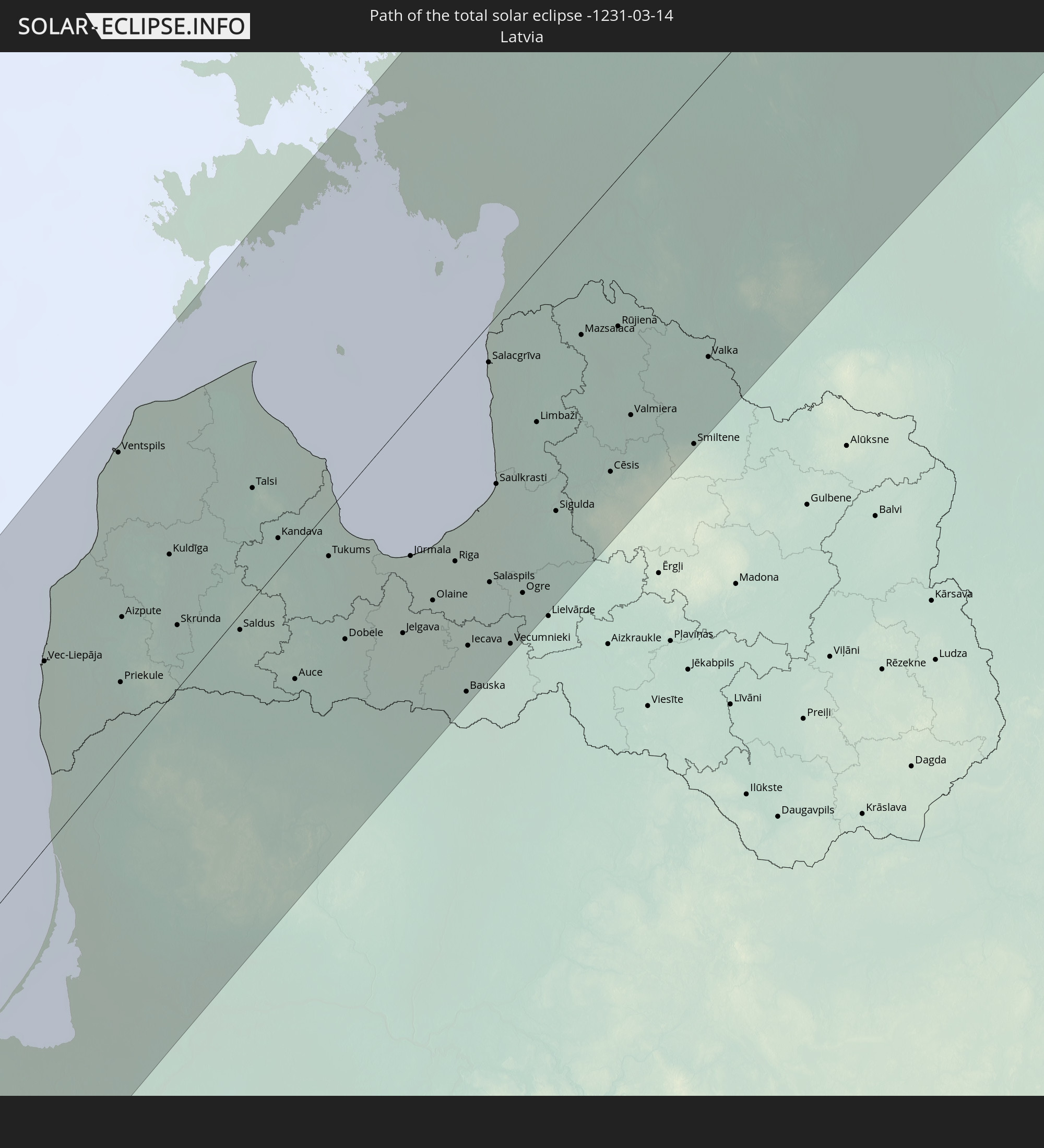 Lettland
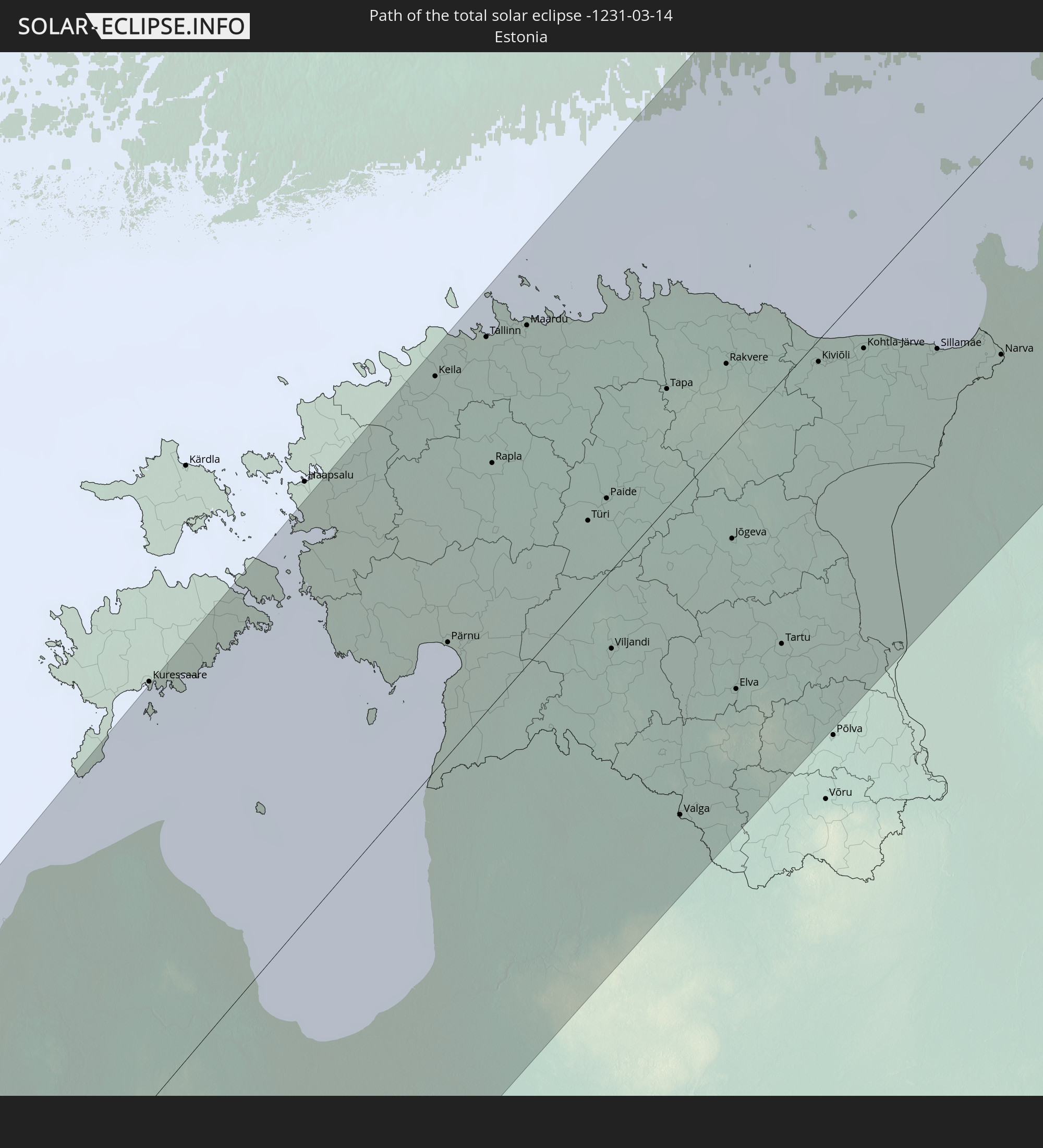 Estland
In den folgenden Ländern ist die Sonnenfinsternis partiell zu sehen
 Russland
 Kanada
 Grönland
 Brasilien
 Saint-Pierre und Miquelon
 Portugal
 Kap Verde
 Island
 Spanien
 Senegal
 Mauretanien
 Gambia
 Guinea-Bissau
 Guinea
 St. Helena
 Sierra Leone
 Marokko
 Mali
Mali
 Liberia
 Irland
 Spitzbergen
 Algerien
 Vereinigtes Königreich
 Elfenbeinküste
 Färöer
 Burkina Faso
 Gibraltar
 Frankreich
 Isle of Man
 Ghana
Ghana
 Guernsey
 Jersey
 Togo
Togo
 Niger
Niger
 Benin
Benin
 Andorra
 Belgien
 Nigeria
 Niederlande
 Norwegen
 Äquatorialguinea
 Luxemburg
 Deutschland
 Schweiz
 São Tomé und Príncipe
 Italien
 Monaco
 Tunesien
 Dänemark
 Kamerun
 Gabun
Gabun
 Libyen
 Liechtenstein
 Österreich
 Schweden
 Republik Kongo
 Tschechien
 Demokratische Republik Kongo
 San Marino
 Vatikanstadt
 Slowenien
 Tschad
 Kroatien
 Polen
Polen
 Malta
Malta
 Zentralafrikanische Republik
 Bosnien und Herzegowina
 Ungarn
 Slowakei
 Montenegro
 Serbien
 Albanien
 Åland Islands
 Griechenland
 Rumänien
 Mazedonien
 Finnland
 Litauen
 Lettland
 Estland
 Sudan
Sudan
 Ukraine
 Bulgarien
 Weißrussland
 Ägypten
 Türkei
 Moldawien
 Republik Zypern
 Staat Palästina
 Israel
 Saudi-Arabien
 Jordanien
 Libanon
 Syrien
 Irak
Irak
 Georgien
 Armenien
 Iran
Iran
 Aserbaidschan
 Kasachstan
 Kuwait
 Turkmenistan
 Usbekistan
 Afghanistan
 Tadschikistan
 Kirgisistan
 Volksrepublik China
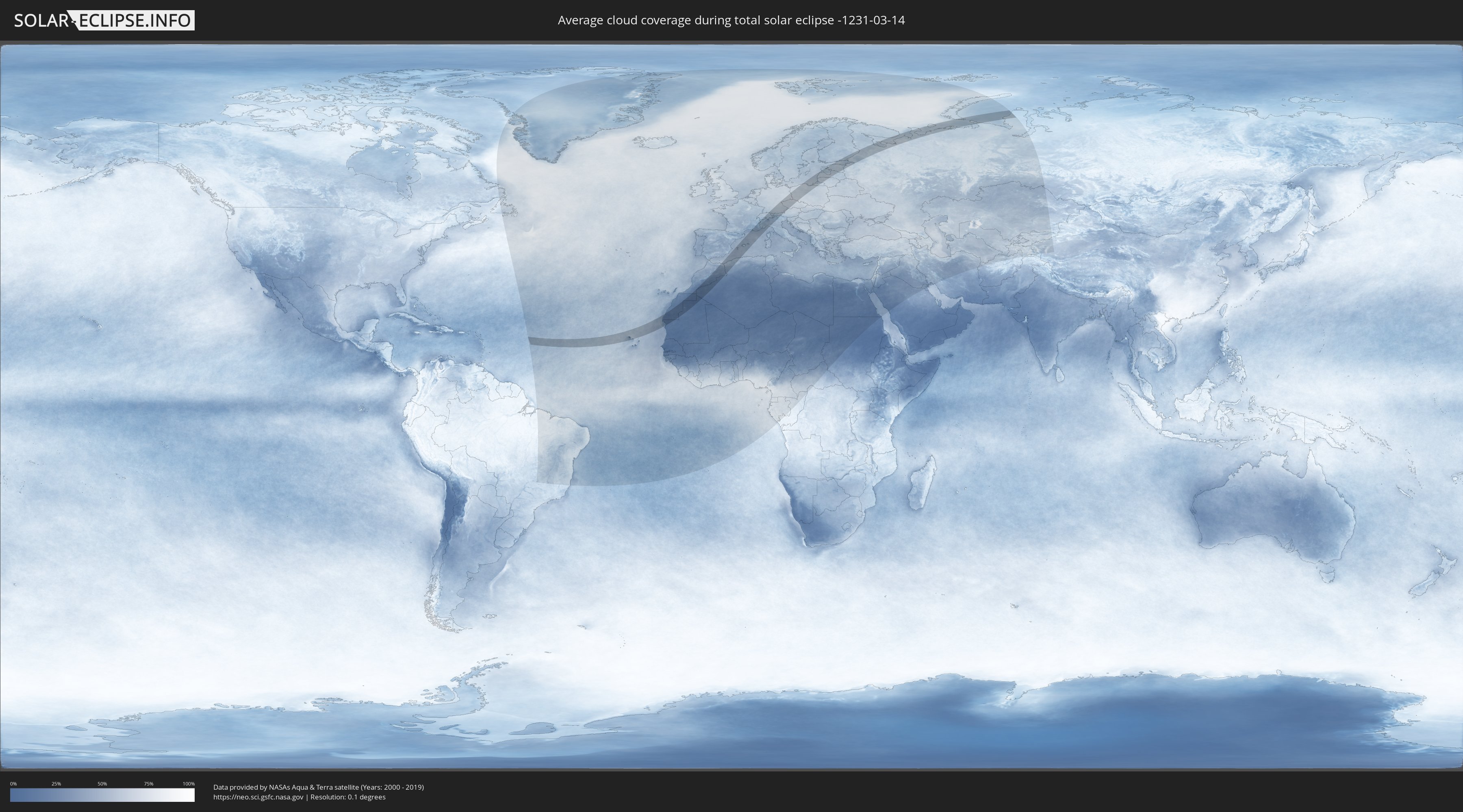
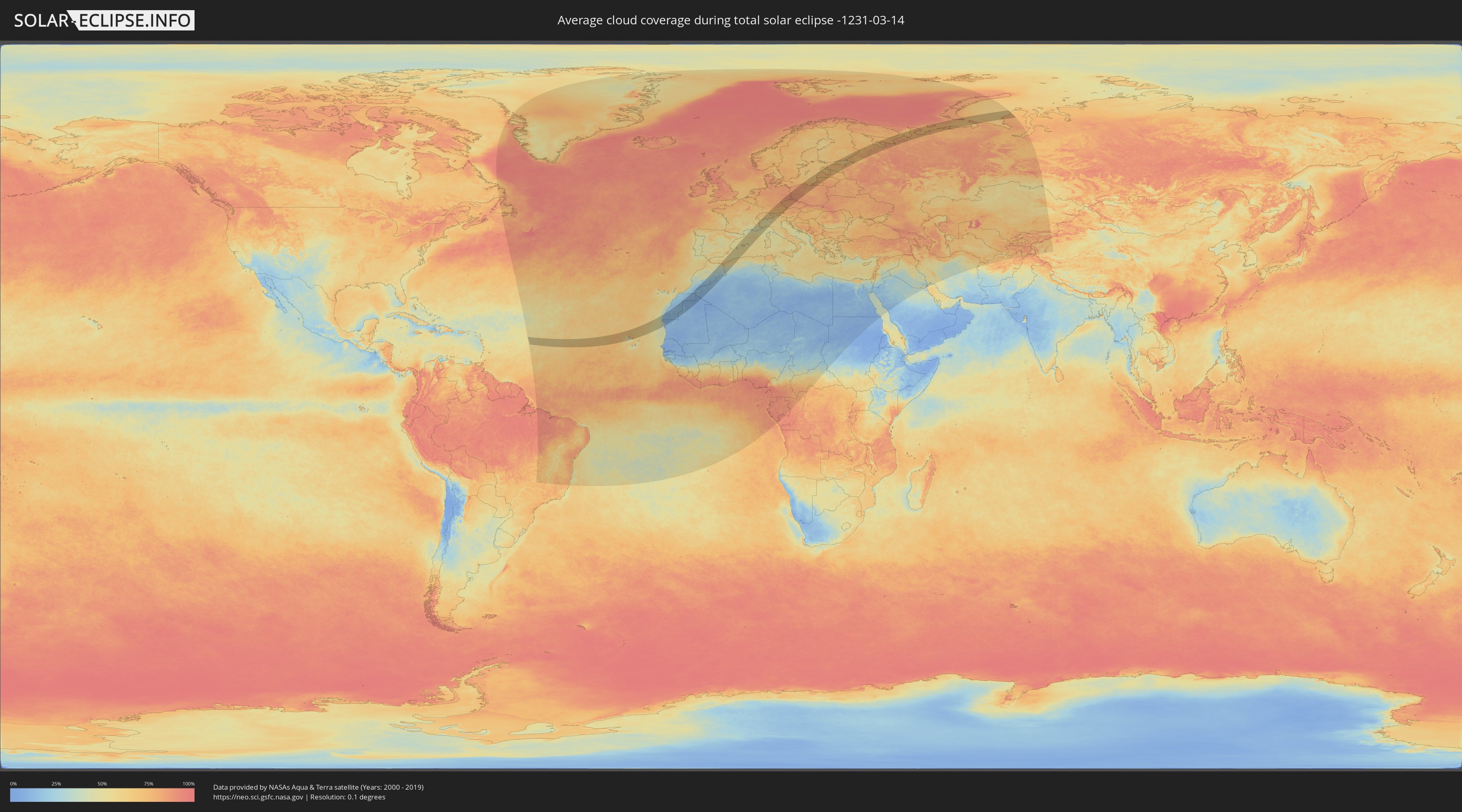
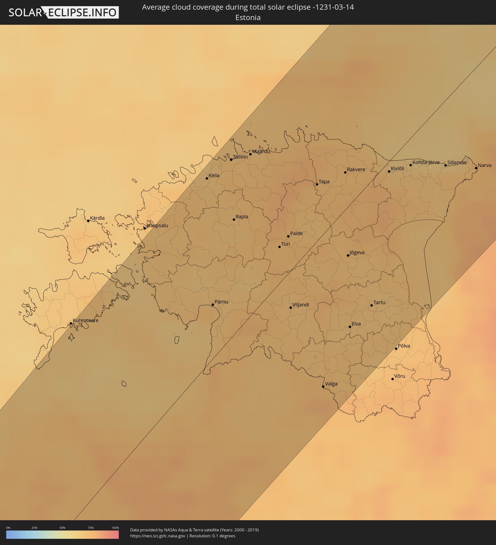
Wie wird das Wetter während der totalen Sonnenfinsternis am 14.03.-1231?
Wo ist der beste Ort, um die totale Sonnenfinsternis vom 14.03.-1231 zu beobachten?
Die folgenden Karten zeigen die durchschnittliche Bewölkung für den Tag, an dem die totale Sonnenfinsternis
stattfindet. Mit Hilfe der Karten lässt sich der Ort entlang des Finsternispfades eingrenzen,
der die besten Aussichen auf einen klaren wolkenfreien Himmel bietet.
Trotzdem muss man immer lokale Gegenenheiten beachten und sollte sich genau über das Wetter an seinem
gewählten Beobachtungsort informieren.
Die Daten stammen von den beiden NASA-Satelliten
AQUA und TERRA
und wurden über einen Zeitraum von 19 Jahren (2000 - 2019) gemittelt.
Detaillierte Länderkarten
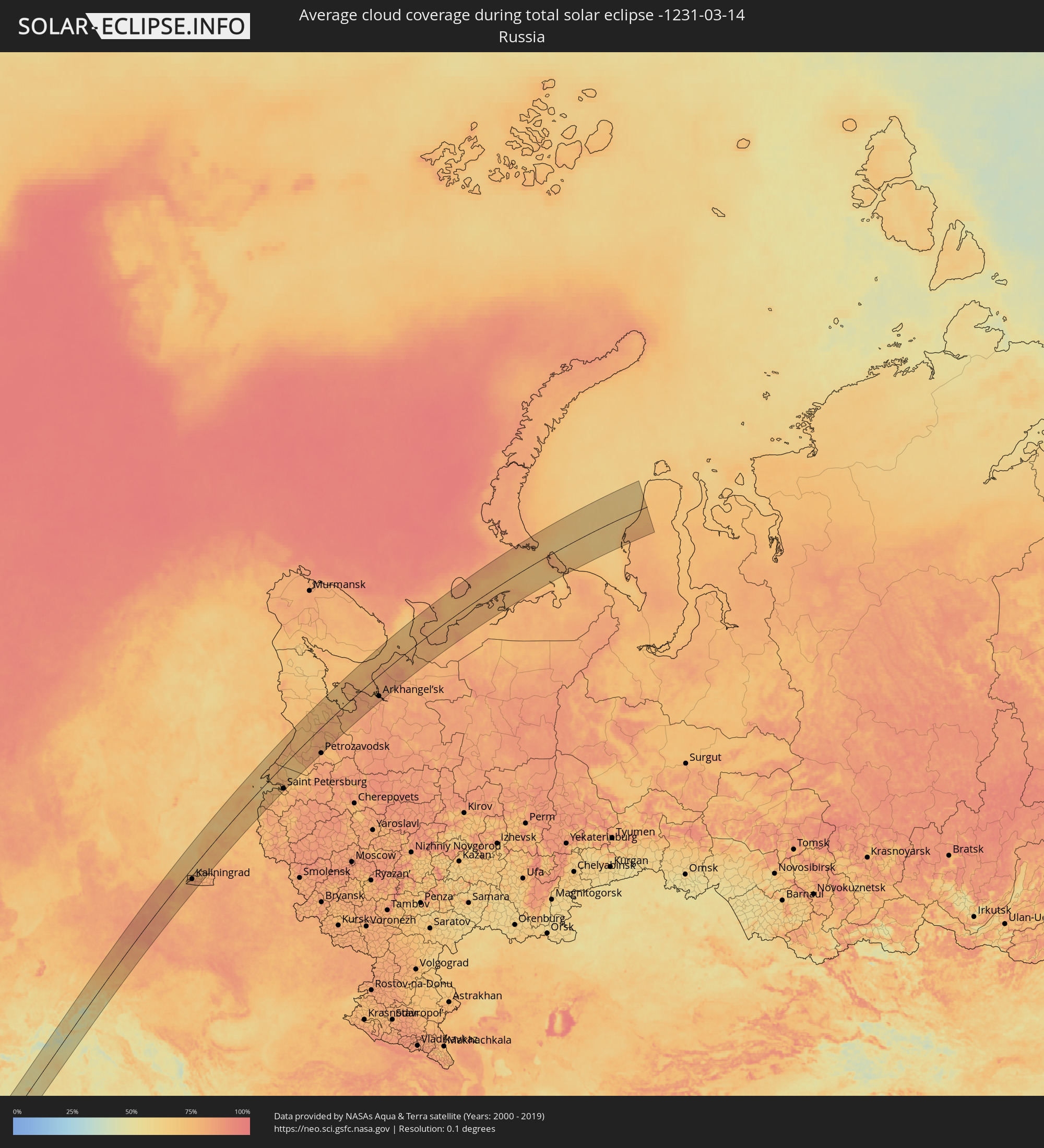 Russland
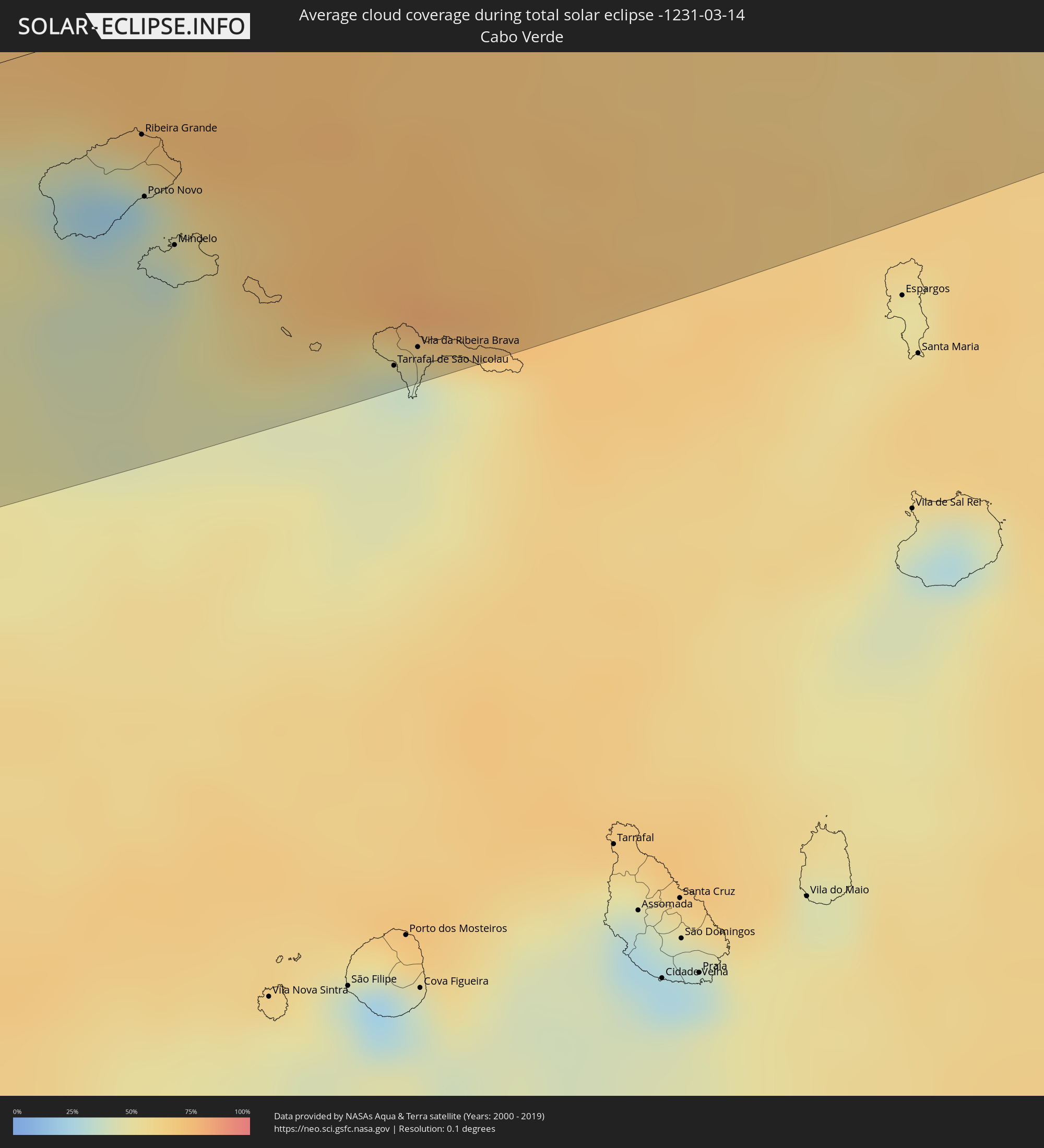 Kap Verde
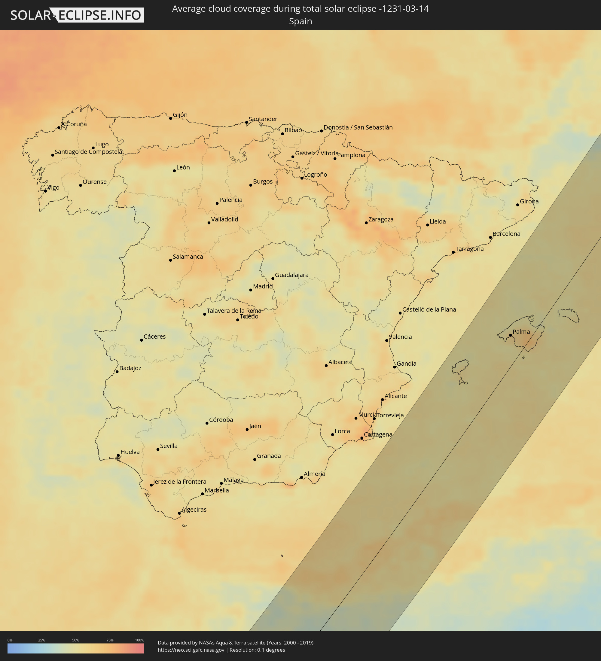 Spanien
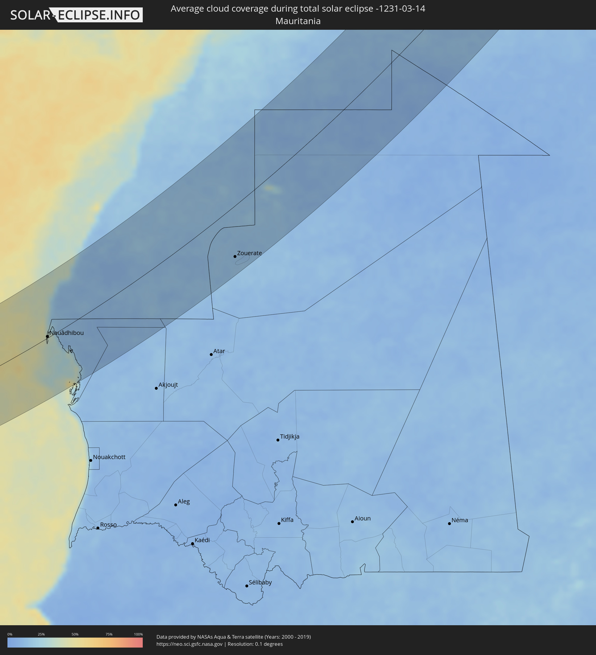 Mauretanien
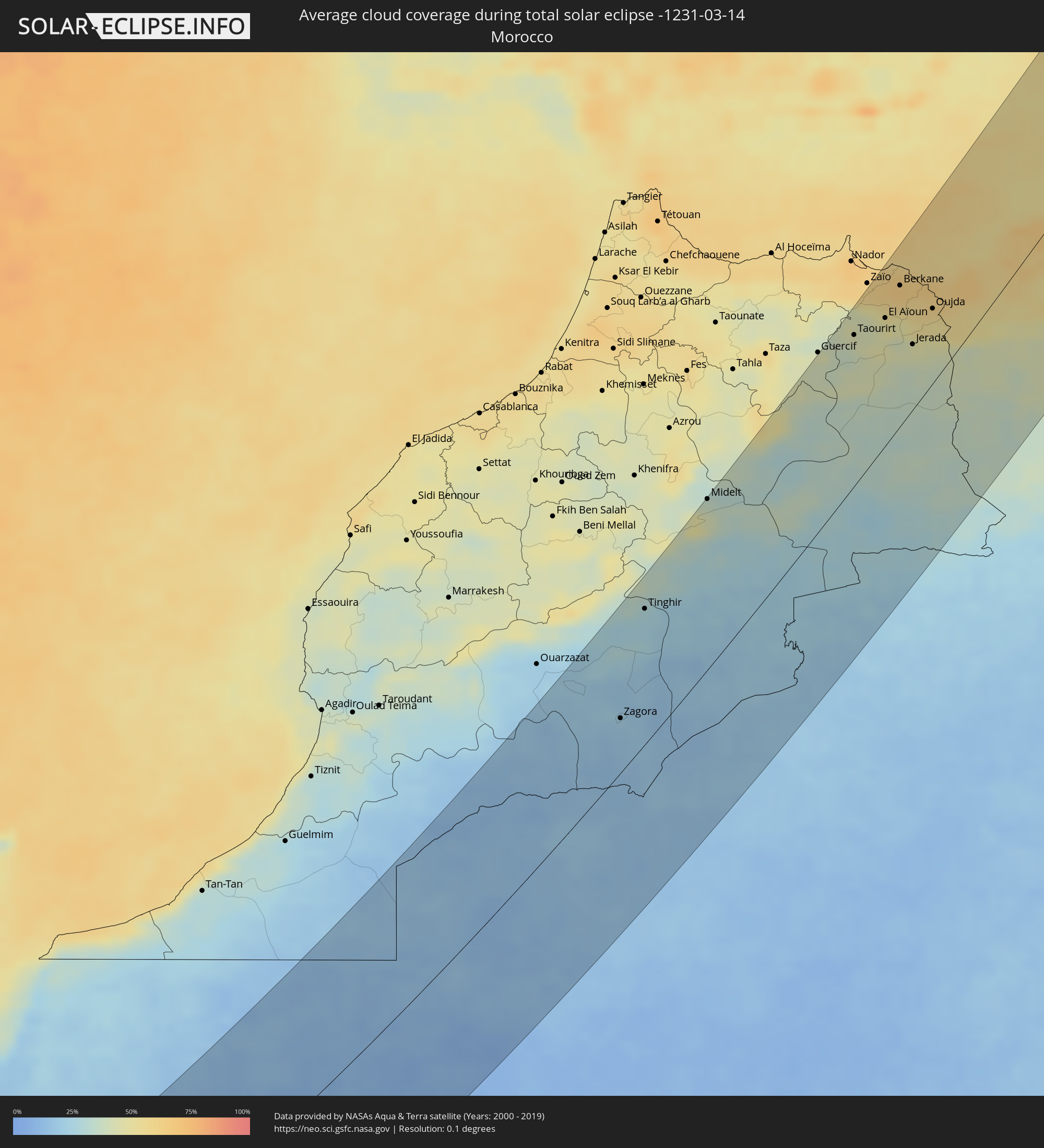 Marokko
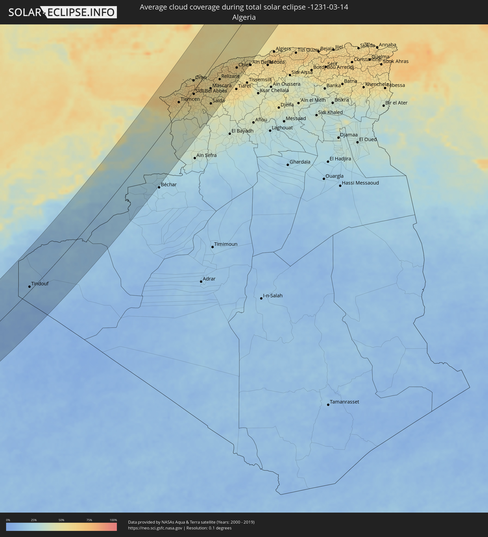 Algerien
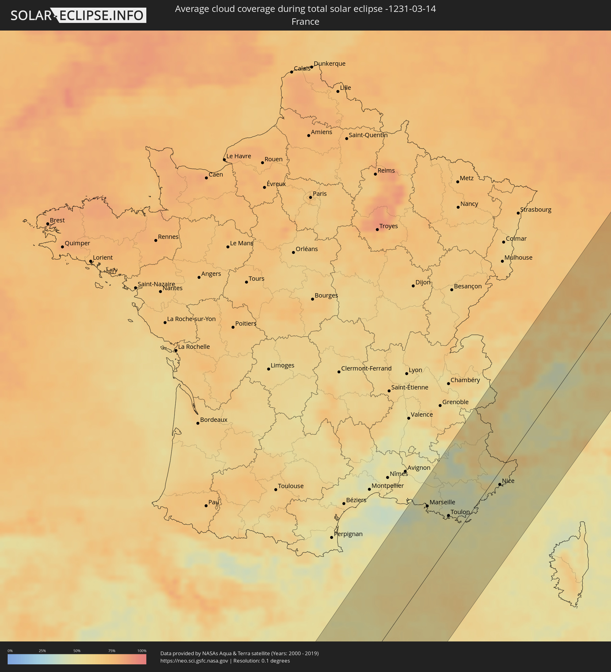 Frankreich
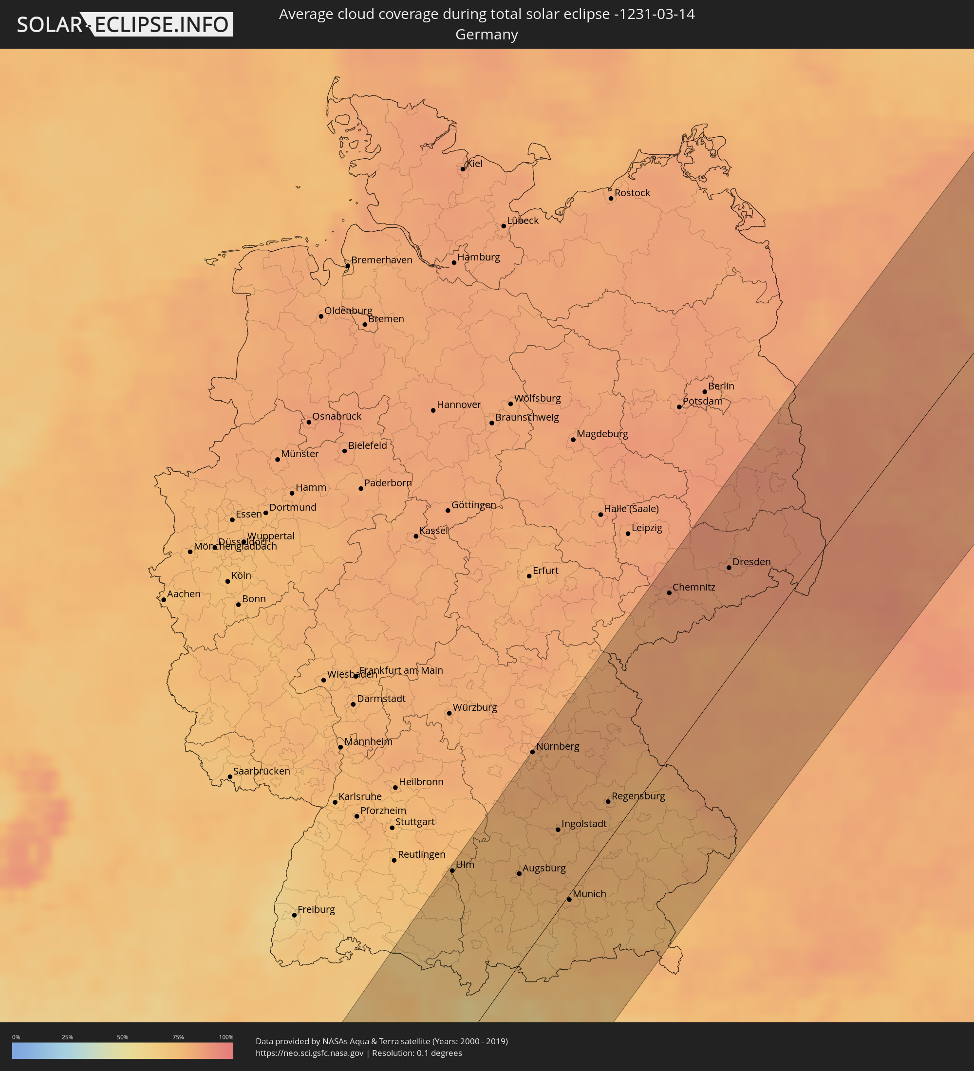 Deutschland
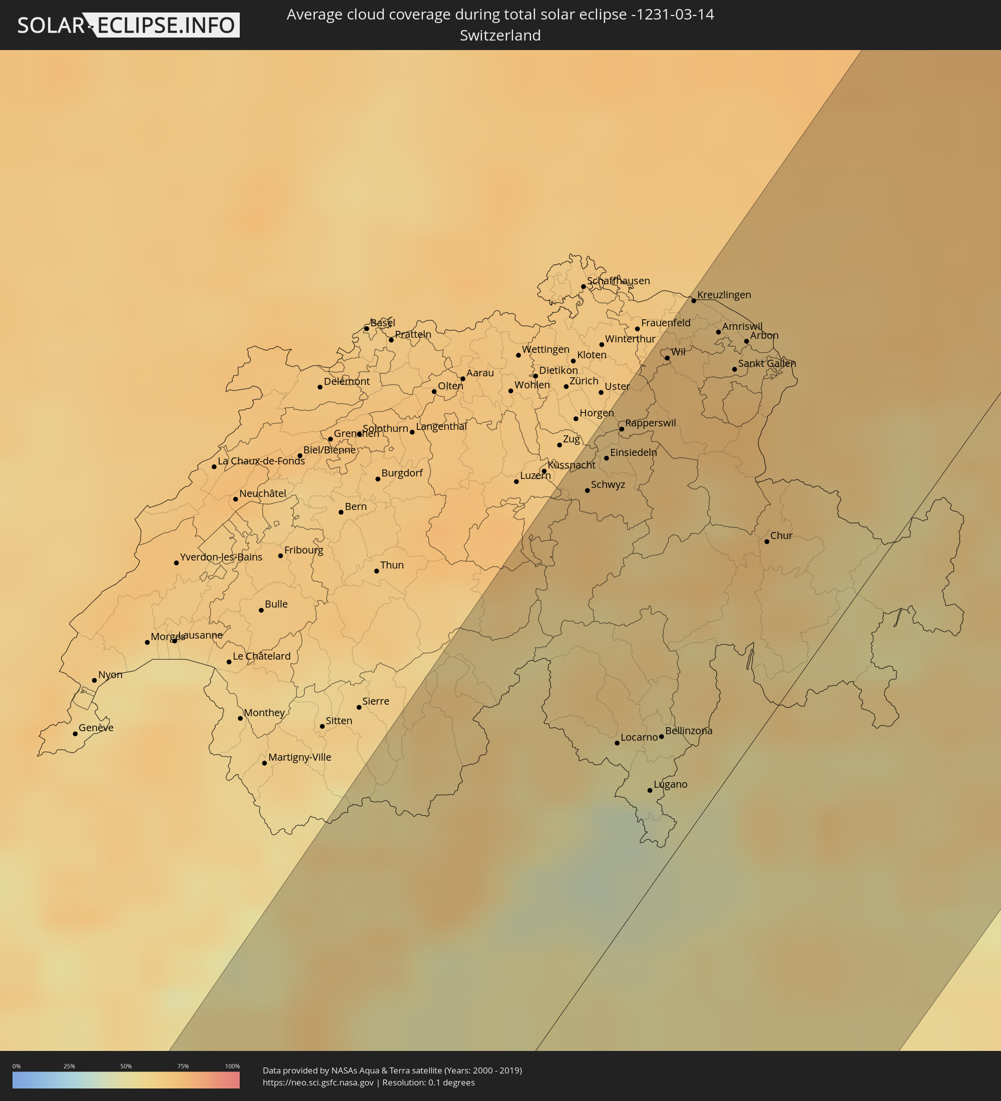 Schweiz
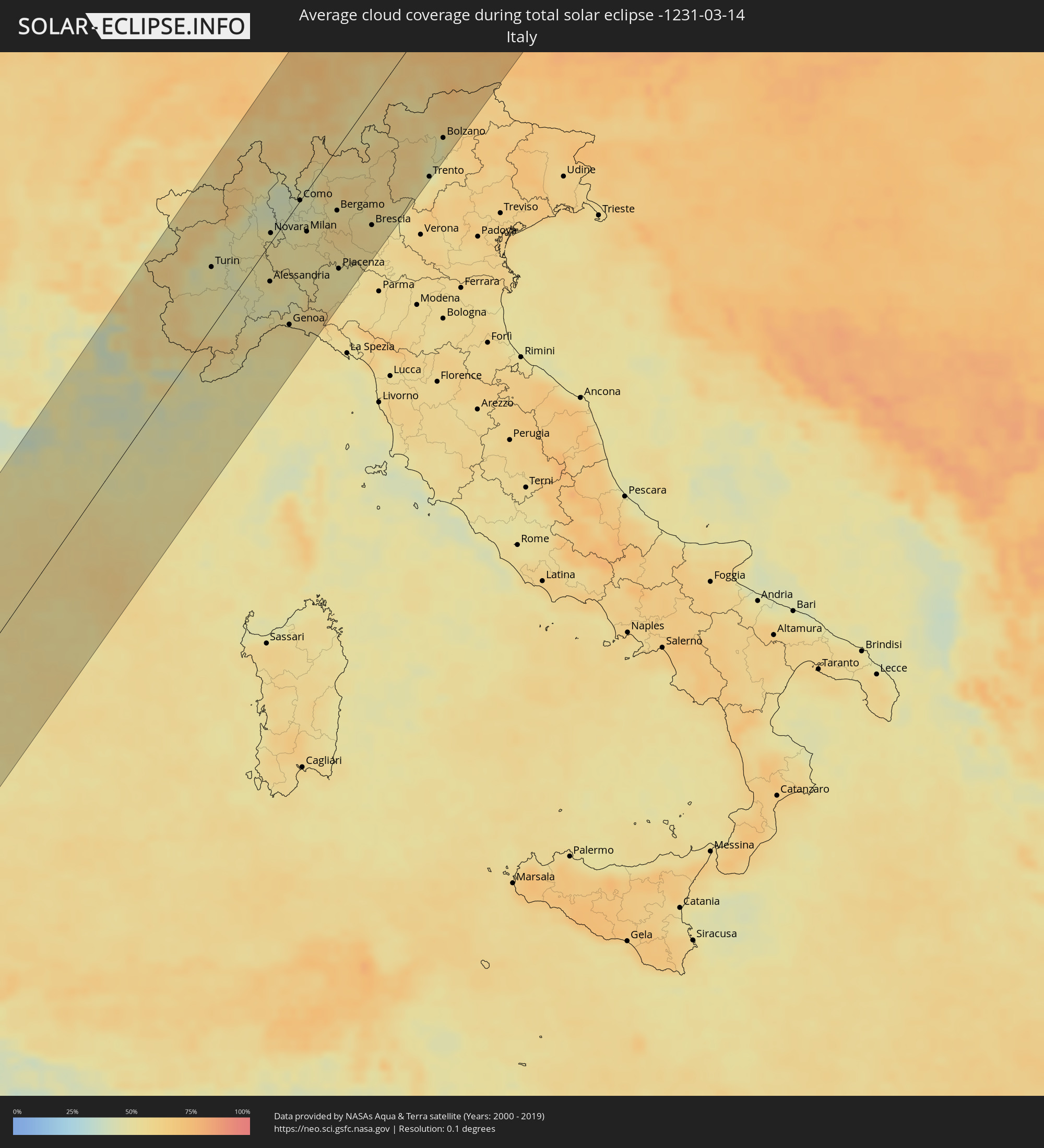 Italien
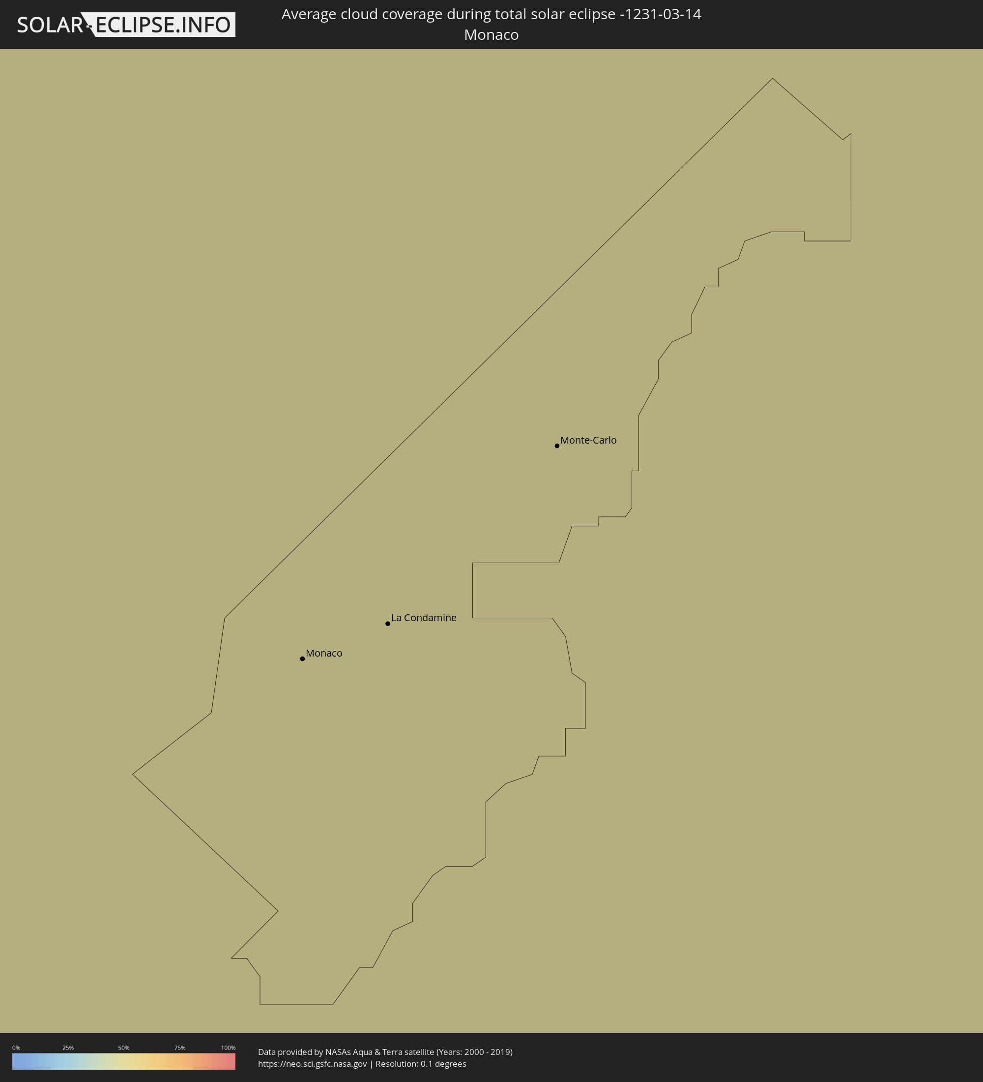 Monaco
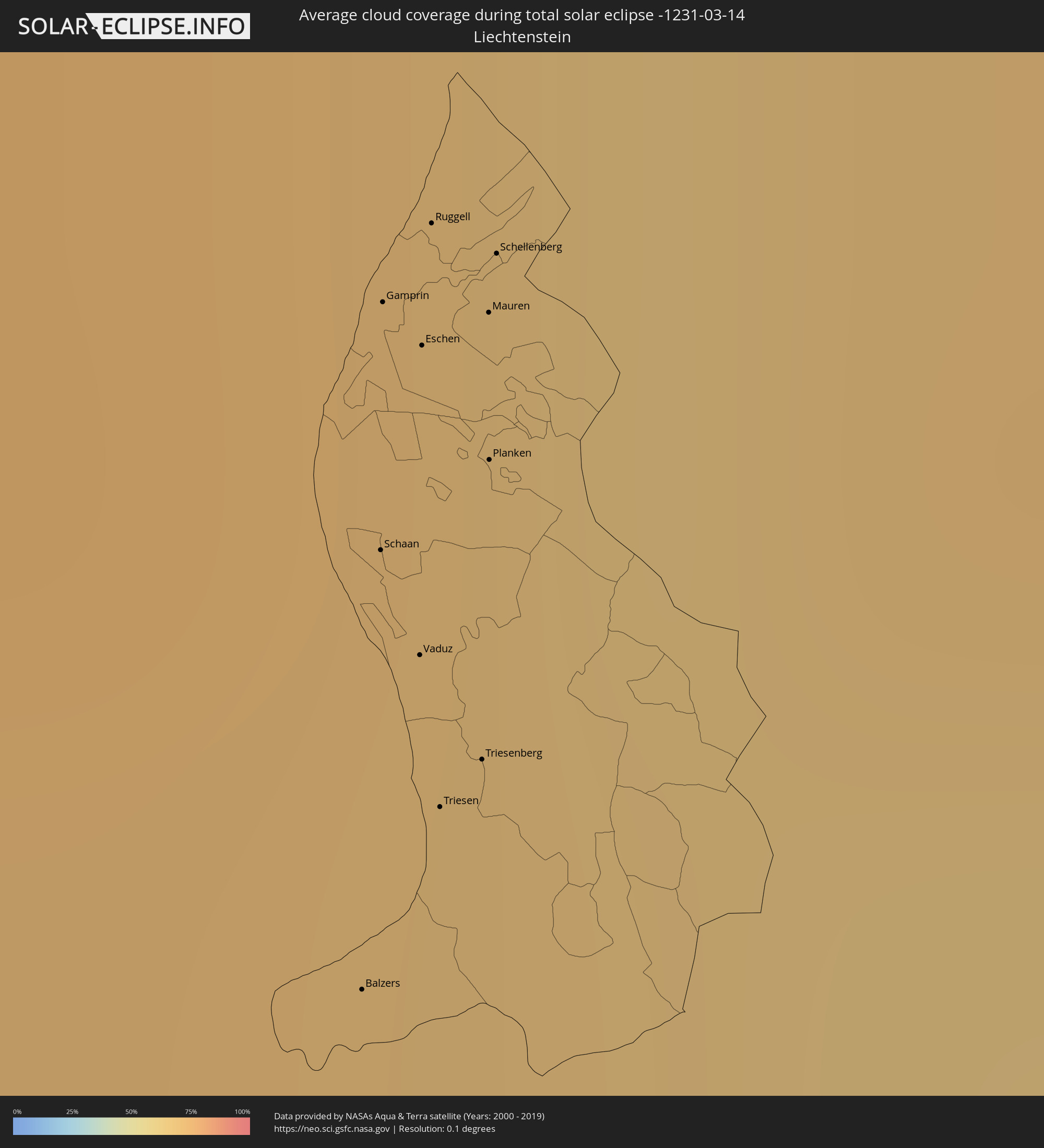 Liechtenstein
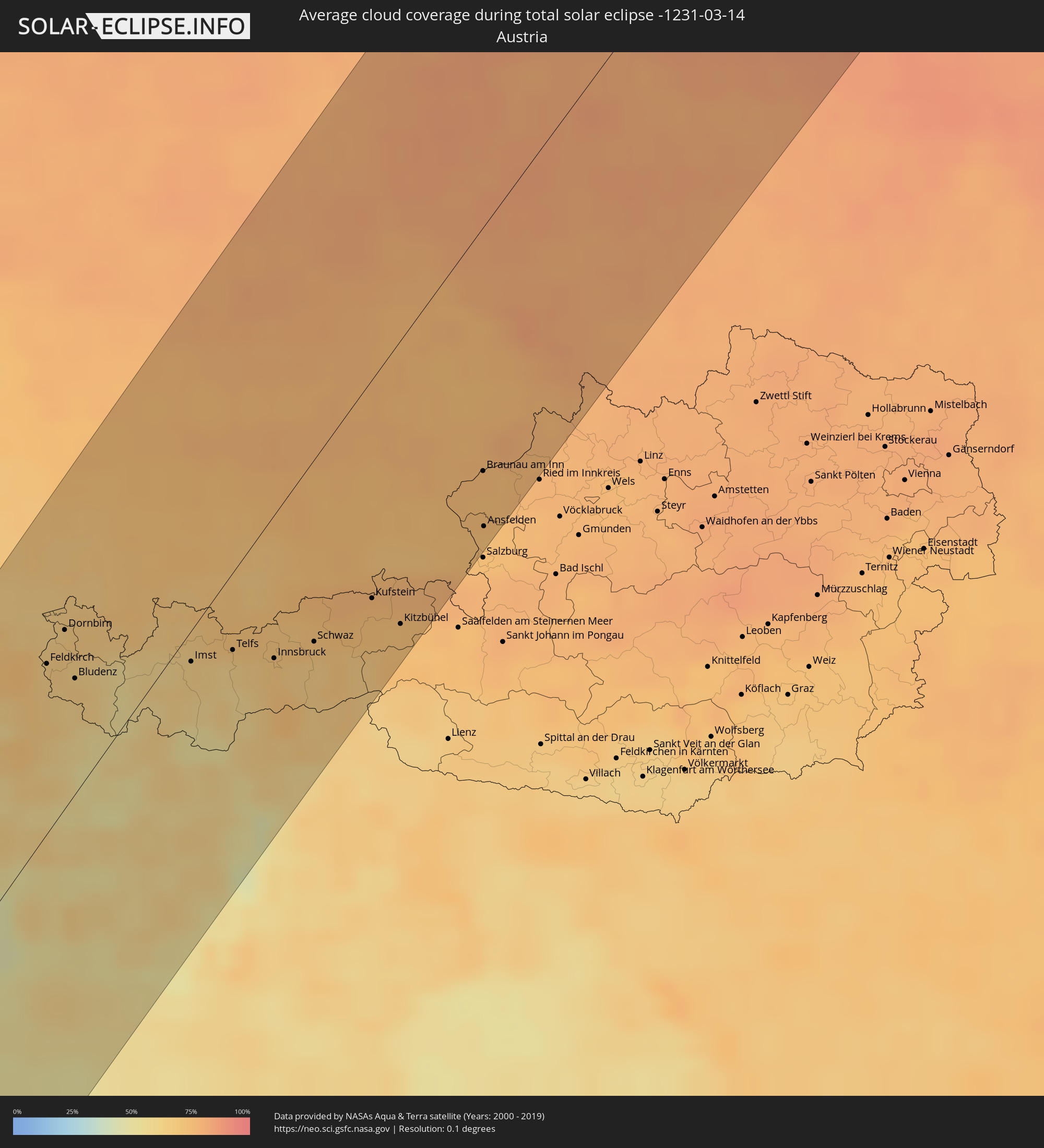 Österreich
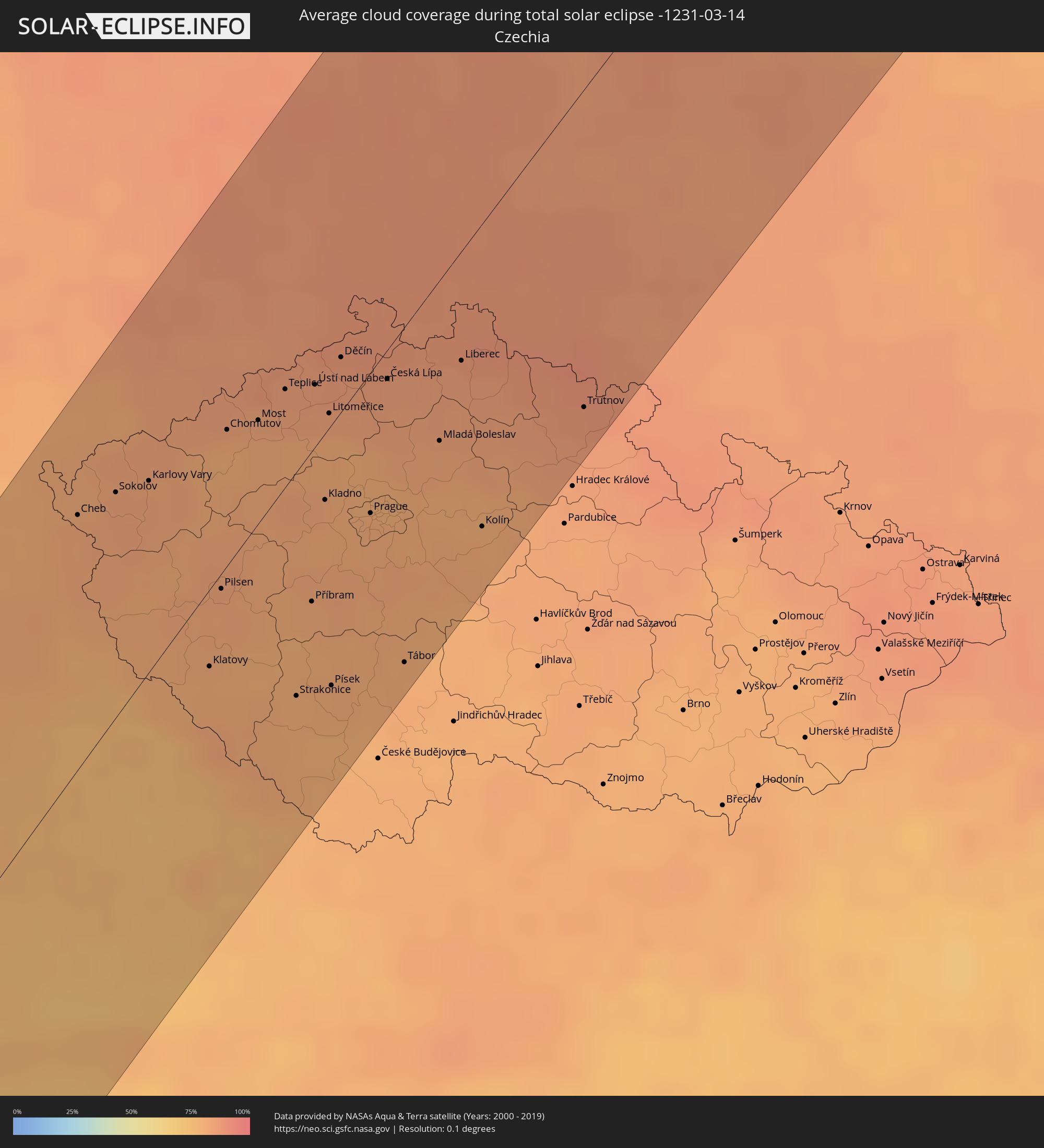 Tschechien
 Polen
Polen
 Finnland
 Litauen
 Lettland
 Estland
Orte im Finsternispfad
Die nachfolgene Tabelle zeigt Städte und Orte mit mehr als 5.000 Einwohnern, die sich im Finsternispfad befinden. Städte mit mehr als 100.000 Einwohnern sind dick gekennzeichnet. Mit einem Klick auf den Ort öffnet sich eine Detailkarte die die Lage des jeweiligen Ortes zusammen mit dem Verlauf der zentralen Finsternis präsentiert.
| Ort | Typ | Dauer der Verfinsterung | Ortszeit bei maximaler Verfinsterung | Entfernung zur Zentrallinie | Ø Bewölkung |
|
Ribeira Grande, Ribeira Grande
|
total | - | 08:24:28 UTC-01:34 | 33 km | 44% |
|
Porto Novo, Porto Novo
|
total | - | 08:24:12 UTC-01:34 | 51 km | 34% |
|
Pombas, Paul
|
total | - | 08:24:27 UTC-01:34 | 38 km | 62% |
|
Mindelo, São Vicente
|
total | - | 08:24:04 UTC-01:34 | 67 km | 35% |
|
Tarrafal de São Nicolau, Tarrafal de São Nicolau
|
total | - | 08:24:12 UTC-01:34 | 121 km | 39% |
|
Vila da Ribeira Brava, Ribeira Brava
|
total | - | 08:24:21 UTC-01:34 | 118 km | 37% |
|
Nouâdhibou, Dakhlet Nouadhibou
|
total | - | 09:58:52 UTC-00:16 | 3 km | 35% |
|
Zouerate, Tiris Zemmour
|
total | - | 10:08:50 UTC-00:16 | 100 km | 13% |
|
Gueltat Zemmour, Laâyoune-Boujdour-Sakia El Hamra
|
total | - | 09:36:50 UTC-00:52 | 101 km | 13% |
|
Zagora, Souss-Massa-Drâa
|
total | - | 10:19:09 UTC-00:30 | 43 km | 18% |
|
Mhamid, Souss-Massa-Drâa
|
total | - | 10:18:25 UTC-00:30 | 3 km | 16% |
|
Tinghir, Souss-Massa-Drâa
|
total | - | 10:21:44 UTC-00:30 | 104 km | 26% |
|
Midelt, Meknès-Tafilalet
|
total | - | 10:25:02 UTC-00:30 | 127 km | 36% |
|
Taourirt, Oriental
|
total | - | 10:30:52 UTC-00:30 | 107 km | 42% |
|
El Aïoun, Oriental
|
total | - | 10:31:47 UTC-00:30 | 89 km | 49% |
|
Berkane, Oriental
|
total | - | 10:32:38 UTC-00:30 | 98 km | 61% |
|
Jerada, Oriental
|
total | - | 10:31:52 UTC-00:30 | 46 km | 43% |
|
Ahfir, Oriental
|
total | - | 10:33:01 UTC-00:30 | 84 km | 64% |
|
Oujda, Oriental
|
total | - | 10:32:53 UTC-00:30 | 52 km | 56% |
|
Tlemcen, Tlemcen
|
total | - | 11:13:49 UTC+00:09 | 21 km | 57% |
|
Aïn Temouchent, Aïn Témouchent
|
total | - | 11:14:46 UTC+00:09 | 36 km | 60% |
|
Oran, Oran
|
total | - | 11:16:10 UTC+00:09 | 25 km | 63% |
|
Sidi Bel Abbès, Sidi Bel Abbès
|
total | - | 11:15:23 UTC+00:09 | 9 km | 59% |
|
Sig, Mascara
|
total | - | 11:16:37 UTC+00:09 | 18 km | 57% |
|
Mostaganem, Mostaganem
|
total | - | 11:17:41 UTC+00:09 | 13 km | 59% |
|
Mascara, Mascara
|
total | - | 11:16:55 UTC+00:09 | 51 km | 56% |
|
Saïda, Saida
|
total | - | 11:16:02 UTC+00:09 | 90 km | 51% |
|
Relizane, Relizane
|
total | - | 11:18:06 UTC+00:09 | 59 km | 57% |
|
Oued Rhiou, Relizane
|
total | - | 11:19:01 UTC+00:09 | 71 km | 60% |
|
Chlef, Chlef
|
total | - | 11:19:59 UTC+00:09 | 88 km | 62% |
|
Ibiza, Balearic Islands
|
total | - | 11:14:52 UTC+00:00 | 82 km | 56% |
|
Palma, Balearic Islands
|
total | - | 11:17:37 UTC+00:00 | 37 km | 58% |
|
Sóller, Balearic Islands
|
total | - | 11:17:59 UTC+00:00 | 45 km | 54% |
|
Llucmajor, Balearic Islands
|
total | - | 11:17:52 UTC+00:00 | 15 km | 60% |
|
Inca, Balearic Islands
|
total | - | 11:18:13 UTC+00:00 | 28 km | 64% |
|
Alcúdia, Balearic Islands
|
total | - | 11:18:42 UTC+00:00 | 22 km | 51% |
|
Santanyí, Balearic Islands
|
total | - | 11:18:02 UTC+00:00 | 10 km | 58% |
|
Manacor, Balearic Islands
|
total | - | 11:18:27 UTC+00:00 | 2 km | 69% |
|
Capdepera, Balearic Islands
|
total | - | 11:18:58 UTC+00:00 | 10 km | 56% |
|
Ciutadella, Balearic Islands
|
total | - | 11:19:58 UTC+00:00 | 19 km | 48% |
|
Maó, Balearic Islands
|
total | - | 11:20:26 UTC+00:00 | 56 km | 55% |
|
Martigues, Provence-Alpes-Côte d'Azur
|
total | - | 11:35:22 UTC+00:09 | 112 km | 46% |
|
Marseille, Provence-Alpes-Côte d'Azur
|
total | - | 11:35:41 UTC+00:09 | 83 km | 48% |
|
Aix-en-Provence, Provence-Alpes-Côte d'Azur
|
total | - | 11:36:03 UTC+00:09 | 93 km | 48% |
|
Aubagne, Provence-Alpes-Côte d'Azur
|
total | - | 11:35:57 UTC+00:09 | 70 km | 46% |
|
Toulon, Provence-Alpes-Côte d'Azur
|
total | - | 11:36:15 UTC+00:09 | 35 km | 49% |
|
Gap, Provence-Alpes-Côte d'Azur
|
total | - | 11:38:06 UTC+00:09 | 116 km | 46% |
|
Hyères, Provence-Alpes-Côte d'Azur
|
total | - | 11:36:32 UTC+00:09 | 21 km | 51% |
|
Fréjus, Provence-Alpes-Côte d'Azur
|
total | - | 11:37:43 UTC+00:09 | 1 km | 43% |
|
Grasse, Provence-Alpes-Côte d'Azur
|
total | - | 11:38:14 UTC+00:09 | 4 km | 51% |
|
Antibes, Provence-Alpes-Côte d'Azur
|
total | - | 11:38:25 UTC+00:09 | 16 km | 48% |
|
Nice, Provence-Alpes-Côte d'Azur
|
total | - | 11:38:46 UTC+00:09 | 17 km | 48% |
|
Monaco
|
total | - | 11:39:00 UTC+00:09 | 25 km | 46% |
|
La Condamine
|
total | - | 11:39:00 UTC+00:09 | 25 km | 46% |
|
Monte-Carlo
|
total | - | 11:39:01 UTC+00:09 | 25 km | 46% |
|
Turin, Piedmont
|
total | - | 12:31:28 UTC+01:00 | 43 km | 49% |
|
Novara, Piedmont
|
total | - | 12:33:05 UTC+01:00 | 7 km | 52% |
|
Schwyz, Schwyz
|
total | - | 12:34:40 UTC+01:00 | 104 km | 66% |
|
Locarno, Ticino
|
total | - | 12:34:03 UTC+01:00 | 41 km | 51% |
|
Rapperswil, Saint Gallen
|
total | - | 12:35:04 UTC+01:00 | 107 km | 67% |
|
Busto Arsizio, Lombardy
|
total | - | 12:33:33 UTC+01:00 | 3 km | 43% |
|
Genoa, Liguria
|
total | - | 12:32:26 UTC+01:00 | 78 km | 55% |
|
Lugano, Ticino
|
total | - | 12:34:06 UTC+01:00 | 21 km | 45% |
|
Bellinzona, Ticino
|
total | - | 12:34:21 UTC+01:00 | 29 km | 52% |
|
Wil, Saint Gallen
|
total | - | 12:35:34 UTC+01:00 | 108 km | 71% |
|
Como, Lombardy
|
total | - | 12:34:04 UTC+01:00 | 1 km | 45% |
|
Kreuzlingen, Thurgau
|
total | - | 12:35:54 UTC+01:00 | 112 km | 64% |
|
Konstanz, Baden-Württemberg
|
total | - | 12:35:55 UTC+01:00 | 112 km | 64% |
|
Milan, Lombardy
|
total | - | 12:33:52 UTC+01:00 | 29 km | 55% |
|
Sankt Gallen, Saint Gallen
|
total | - | 12:35:57 UTC+01:00 | 85 km | 71% |
|
Buchs, Saint Gallen
|
total | - | 12:35:51 UTC+01:00 | 62 km | 69% |
|
Balzers, Balzers
|
total | - | 12:35:48 UTC+01:00 | 54 km | 69% |
|
Schaan, Schaan
|
total | - | 12:35:53 UTC+01:00 | 60 km | 69% |
|
Gamprin, Gamprin
|
total | - | 12:35:57 UTC+01:00 | 64 km | 69% |
|
Vaduz, Vaduz
|
total | - | 12:35:53 UTC+01:00 | 58 km | 69% |
|
Eschen, Eschen
|
total | - | 12:35:57 UTC+01:00 | 62 km | 69% |
|
Ruggell, Ruggell
|
total | - | 12:35:59 UTC+01:00 | 64 km | 69% |
|
Triesen, Triesen
|
total | - | 12:35:52 UTC+01:00 | 55 km | 69% |
|
Chur, Grisons
|
total | - | 12:35:38 UTC+01:00 | 39 km | 65% |
|
Triesenberg, Triesenberg
|
total | - | 12:35:53 UTC+01:00 | 55 km | 69% |
|
Mauren, Mauren
|
total | - | 12:35:59 UTC+01:00 | 61 km | 69% |
|
Planken, Planken
|
total | - | 12:35:57 UTC+01:00 | 59 km | 69% |
|
Schellenberg, Schellenberg
|
total | - | 12:36:00 UTC+01:00 | 62 km | 69% |
|
Feldkirch, Vorarlberg
|
total | - | 12:36:04 UTC+01:00 | 59 km | 66% |
|
Bergamo, Lombardy
|
total | - | 12:34:43 UTC+01:00 | 44 km | 56% |
|
Piacenza, Emilia-Romagna
|
total | - | 12:34:07 UTC+01:00 | 87 km | 50% |
|
Dornbirn, Vorarlberg
|
total | - | 12:36:25 UTC+01:00 | 62 km | 68% |
|
Bludenz, Vorarlberg
|
total | - | 12:36:17 UTC+01:00 | 40 km | 67% |
|
Davos, Grisons
|
total | - | 12:35:59 UTC+01:00 | 17 km | 56% |
|
Ulm, Baden-Württemberg
|
total | - | 12:37:35 UTC+01:00 | 109 km | 75% |
|
Brescia, Lombardy
|
total | - | 12:35:17 UTC+01:00 | 89 km | 56% |
|
Imst, Tyrol
|
total | - | 12:37:32 UTC+01:00 | 11 km | 65% |
|
Augsburg, Bavaria
|
total | - | 12:38:41 UTC+01:00 | 52 km | 75% |
|
Telfs, Tyrol
|
total | - | 12:38:00 UTC+01:00 | 27 km | 63% |
|
Nürnberg, Bavaria
|
total | - | 12:39:46 UTC+01:00 | 111 km | 79% |
|
Trento, Trentino-Alto Adige
|
total | - | 12:36:58 UTC+01:00 | 111 km | 49% |
|
Bolzano, Trentino-Alto Adige
|
total | - | 12:37:37 UTC+01:00 | 97 km | 46% |
|
Innsbruck, Tyrol
|
total | - | 12:38:22 UTC+01:00 | 50 km | 69% |
|
Ingolstadt, Bavaria
|
total | - | 12:39:38 UTC+01:00 | 46 km | 76% |
|
Munich, Bavaria
|
total | - | 12:39:19 UTC+01:00 | 4 km | 76% |
|
Schwaz, Tyrol
|
total | - | 12:38:50 UTC+01:00 | 63 km | 70% |
|
Regensburg, Bavaria
|
total | - | 12:40:39 UTC+01:00 | 22 km | 76% |
|
Kufstein, Tyrol
|
total | - | 12:39:36 UTC+01:00 | 76 km | 74% |
|
Kitzbühel, Tyrol
|
total | - | 12:39:46 UTC+01:00 | 98 km | 72% |
|
Zwickau, Saxony
|
total | - | 12:42:21 UTC+01:00 | 111 km | 81% |
|
Karlovy Vary, Karlovarský
|
total | - | 12:42:27 UTC+01:00 | 57 km | 83% |
|
Chemnitz, Saxony
|
total | - | 12:42:56 UTC+01:00 | 93 km | 84% |
|
Braunau am Inn, Upper Austria
|
total | - | 12:41:13 UTC+01:00 | 84 km | 75% |
|
Ansfelden, Salzburg
|
total | - | 12:41:00 UTC+01:00 | 103 km | 72% |
|
Pilsen, Plzeňský
|
total | - | 12:42:43 UTC+01:00 | 5 km | 82% |
|
Chomutov, Ústecký
|
total | - | 12:43:15 UTC+01:00 | 40 km | 81% |
|
Most, Ústecký
|
total | - | 12:43:32 UTC+01:00 | 30 km | 81% |
|
Dresden, Saxony
|
total | - | 12:44:00 UTC+01:00 | 61 km | 85% |
|
Ústí nad Labem, Ústecký
|
total | - | 12:44:05 UTC+01:00 | 18 km | 85% |
|
Kladno, Central Bohemia
|
total | - | 12:43:50 UTC+01:00 | 20 km | 82% |
|
Děčín, Ústecký
|
total | - | 12:44:22 UTC+01:00 | 16 km | 86% |
|
Cottbus, Brandenburg
|
total | - | 12:45:05 UTC+01:00 | 74 km | 87% |
|
Prague, Praha
|
total | - | 12:44:10 UTC+01:00 | 42 km | 81% |
|
Česká Lípa, Liberecký
|
total | - | 12:44:41 UTC+01:00 | 9 km | 85% |
|
Mladá Boleslav, Central Bohemia
|
total | - | 12:44:56 UTC+01:00 | 48 km | 82% |
|
Liberec, Liberecký
|
total | - | 12:45:19 UTC+01:00 | 32 km | 86% |
|
Gorzów Wielkopolski, Lubusz
|
total | - | 13:10:37 UTC+01:24 | 90 km | 82% |
|
Zielona Góra, Lubusz
|
total | - | 13:10:30 UTC+01:24 | 21 km | 86% |
|
Legnica, Lower Silesian Voivodeship
|
total | - | 13:10:50 UTC+01:24 | 64 km | 87% |
|
Wałbrzych, Lower Silesian Voivodeship
|
total | - | 13:10:43 UTC+01:24 | 101 km | 86% |
|
Poznań, Greater Poland Voivodeship
|
total | - | 13:12:18 UTC+01:24 | 24 km | 86% |
|
Bydgoszcz, Kujawsko-Pomorskie
|
total | - | 13:13:46 UTC+01:24 | 32 km | 83% |
|
Gdynia, Pomeranian Voivodeship
|
total | - | 13:14:51 UTC+01:24 | 37 km | 81% |
|
Toruń, Kujawsko-Pomorskie
|
total | - | 13:14:20 UTC+01:24 | 71 km | 78% |
|
Gdańsk, Pomeranian Voivodeship
|
total | - | 13:14:54 UTC+01:24 | 20 km | 83% |
|
Grudziądz, Kujawsko-Pomorskie
|
total | - | 13:14:41 UTC+01:24 | 46 km | 79% |
|
Elbląg, Warmian-Masurian Voivodeship
|
total | - | 13:15:36 UTC+01:24 | 33 km | 82% |
|
Kaliningrad, Kaliningrad
|
total | - | 12:52:52 UTC+01:00 | 49 km | 83% |
|
Vec-Liepāja, Liepāja
|
total | - | 13:30:22 UTC+01:36 | 55 km | 70% |
|
Palanga, Klaipėda County
|
total | - | 13:17:43 UTC+01:24 | 9 km | 70% |
|
Klaipėda, Klaipėda County
|
total | - | 13:17:43 UTC+01:24 | 7 km | 70% |
|
Kretinga, Klaipėda County
|
total | - | 13:17:53 UTC+01:24 | 2 km | 75% |
|
Gargždai, Klaipėda County
|
total | - | 13:18:00 UTC+01:24 | 21 km | 76% |
|
Silute, Klaipėda County
|
total | - | 13:17:59 UTC+01:24 | 51 km | 74% |
|
Ventspils, Ventspils
|
total | - | 13:31:02 UTC+01:36 | 90 km | 69% |
|
Plunge, Telšiai County
|
total | - | 13:18:27 UTC+01:24 | 28 km | 75% |
|
Kuldīga, Kuldīgas Rajons
|
total | - | 13:31:19 UTC+01:36 | 42 km | 75% |
|
Telsiai, Telšiai County
|
total | - | 13:18:51 UTC+01:24 | 42 km | 76% |
|
Taurage, Tauragė County
|
total | - | 13:18:44 UTC+01:24 | 97 km | 78% |
|
Mazeikiai, Telšiai County
|
total | - | 13:18:59 UTC+01:24 | 22 km | 79% |
|
Kuršėnai, Šiauliai County
|
total | - | 13:19:29 UTC+01:24 | 73 km | 77% |
|
Tukums, Tukuma Rajons
|
total | - | 13:32:24 UTC+01:36 | 14 km | 76% |
|
Šiauliai, Šiauliai County
|
total | - | 13:19:50 UTC+01:24 | 96 km | 79% |
|
Jelgava, Jelgava
|
total | - | 13:32:52 UTC+01:36 | 63 km | 76% |
|
Jūrmala, Jūrmala
|
total | - | 13:32:57 UTC+01:36 | 42 km | 79% |
|
Riga, Riga
|
total | - | 13:33:15 UTC+01:36 | 59 km | 78% |
|
Salaspils, Salaspils
|
total | - | 13:33:28 UTC+01:36 | 77 km | 76% |
|
Pärnu, Pärnumaa
|
total | - | 13:36:07 UTC+01:39 | 29 km | 74% |
|
Ogre, Ogre
|
total | - | 13:33:41 UTC+01:36 | 92 km | 76% |
|
Tallinn, Harjumaa
|
total | - | 13:36:20 UTC+01:39 | 95 km | 72% |
|
Maardu, Harjumaa
|
total | - | 13:36:33 UTC+01:39 | 86 km | 72% |
|
Cēsis, Cēsu Rajons
|
total | - | 13:34:18 UTC+01:36 | 85 km | 74% |
|
Valmiera, Valmieras Rajons
|
total | - | 13:34:27 UTC+01:36 | 74 km | 72% |
|
Viljandi, Viljandimaa
|
total | - | 13:37:02 UTC+01:39 | 20 km | 70% |
|
Valga, Valgamaa
|
total | - | 13:37:25 UTC+01:39 | 84 km | 74% |
|
Rakvere, Lääne-Virumaa
|
total | - | 13:37:38 UTC+01:39 | 20 km | 74% |
|
Tartu, Tartu
|
total | - | 13:37:59 UTC+01:39 | 68 km | 70% |
|
Anjala, Kymenlaakso
|
total | - | 13:38:43 UTC+01:39 | 99 km | 68% |
|
Kotka, Kymenlaakso
|
total | - | 13:38:49 UTC+01:39 | 80 km | 65% |
|
Karhula, Kymenlaakso
|
total | - | 13:38:49 UTC+01:39 | 83 km | 65% |
|
Hamina, Kymenlaakso
|
total | - | 13:39:01 UTC+01:39 | 76 km | 69% |
|
Kohtla-Järve, Ida-Virumaa
|
total | - | 13:38:22 UTC+01:39 | 15 km | 71% |
|
Jõhvi, Ida-Virumaa
|
total | - | 13:38:30 UTC+01:39 | 24 km | 70% |
|
Sillamäe, Ida-Virumaa
|
total | - | 13:38:46 UTC+01:39 | 35 km | 73% |
|
Lappeenranta, South Karelia
|
total | - | 13:39:42 UTC+01:39 | 73 km | 66% |
|
Narva, Ida-Virumaa
|
total | - | 13:39:06 UTC+01:39 | 54 km | 73% |
|
Joutseno, South Karelia
|
total | - | 13:39:55 UTC+01:39 | 65 km | 67% |
|
Kingisepp, Leningradskaya Oblast'
|
total | - | 14:30:43 UTC+02:30 | 72 km | 74% |
|
Imatra, South Karelia
|
total | - | 13:40:06 UTC+01:39 | 59 km | 71% |
|
Vyborg, Leningradskaya Oblast'
|
total | - | 14:30:38 UTC+02:30 | 24 km | 71% |
|
Ruokolahti, South Karelia
|
total | - | 13:40:08 UTC+01:39 | 65 km | 70% |
|
Sosnovyy Bor, Leningradskaya Oblast'
|
total | - | 14:31:01 UTC+02:30 | 51 km | 73% |
|
Kerimäki, Southern Savonia
|
total | - | 13:40:20 UTC+01:39 | 95 km | 66% |
|
Peterhof, St.-Petersburg
|
total | - | 14:31:38 UTC+02:30 | 85 km | 72% |
|
Kurortnyy, Leningradskaya Oblast'
|
total | - | 14:31:36 UTC+02:30 | 63 km | 77% |
|
Krasnoye Selo, St.-Petersburg
|
total | - | 14:31:48 UTC+02:30 | 104 km | 72% |
|
Kitee, North Karelia
|
total | - | 13:40:54 UTC+01:39 | 77 km | 72% |
|
Saint Petersburg, St.-Petersburg
|
total | - | 14:31:56 UTC+02:30 | 97 km | 81% |
|
Ilomantsi, North Karelia
|
total | - | 13:41:17 UTC+01:39 | 91 km | 75% |
|
Petrozavodsk, Republic of Karelia
|
total | - | 14:34:19 UTC+02:30 | 103 km | 77% |
|
Severodvinsk, Arkhangelskaya
|
total | - | 14:36:24 UTC+02:30 | 57 km | 78% |
|
Arkhangel’sk, Arkhangelskaya
|
total | - | 14:36:48 UTC+02:30 | 81 km | 83% |