Hybride Sonnenfinsternis vom 22.11.-1626
| Wochentag: | Donnerstag |
| Maximale Dauer der Verfinsterung: | 00m43s |
| Maximale Breite des Finsternispfades: | 35 km |
| Saroszyklus: | 26 |
| Bedeckungsgrad: | 100% |
| Magnitude: | 1.0089 |
| Gamma: | -0.4691 |
Wo kann man die Sonnenfinsternis vom 22.11.-1626 sehen?
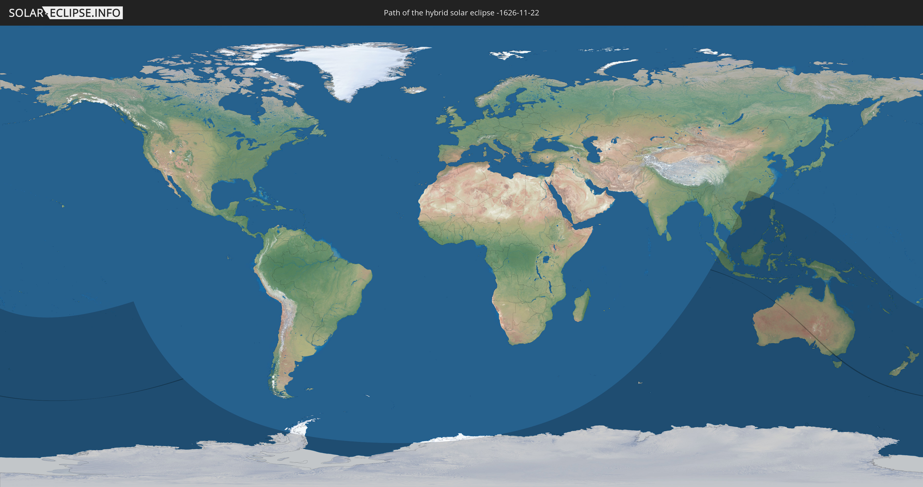
Die Sonnenfinsternis am 22.11.-1626 kann man in 31 Ländern als partielle Sonnenfinsternis beobachten.
Der Finsternispfad verläuft durch 2 Länder. Nur in diesen Ländern ist sie als hybride Sonnenfinsternis zu sehen.
In den folgenden Ländern ist die Sonnenfinsternis hybrid zu sehen
 Neuseeland
 Australien
In den folgenden Ländern ist die Sonnenfinsternis partiell zu sehen
 Antarktika
 Fidschi
 Neuseeland
 Tonga
Tonga
 Französisch-Polynesien
 Pitcairninseln
 Französische Süd- und Antarktisgebiete
 Heard und McDonaldinseln
 Volksrepublik China
 Indonesien
 Kokosinseln
 Malaysia
 Laos
Laos
 Vietnam
 Kambodscha
 Singapur
 Weihnachtsinsel
 Australien
 Macau
Macau
 Hongkong
 Brunei
 Taiwan
 Philippinen
 Osttimor
 Palau
Palau
 Föderierte Staaten von Mikronesien
 Papua-Neuguinea
 Salomonen
 Neukaledonien
 Vanuatu
 Norfolkinsel
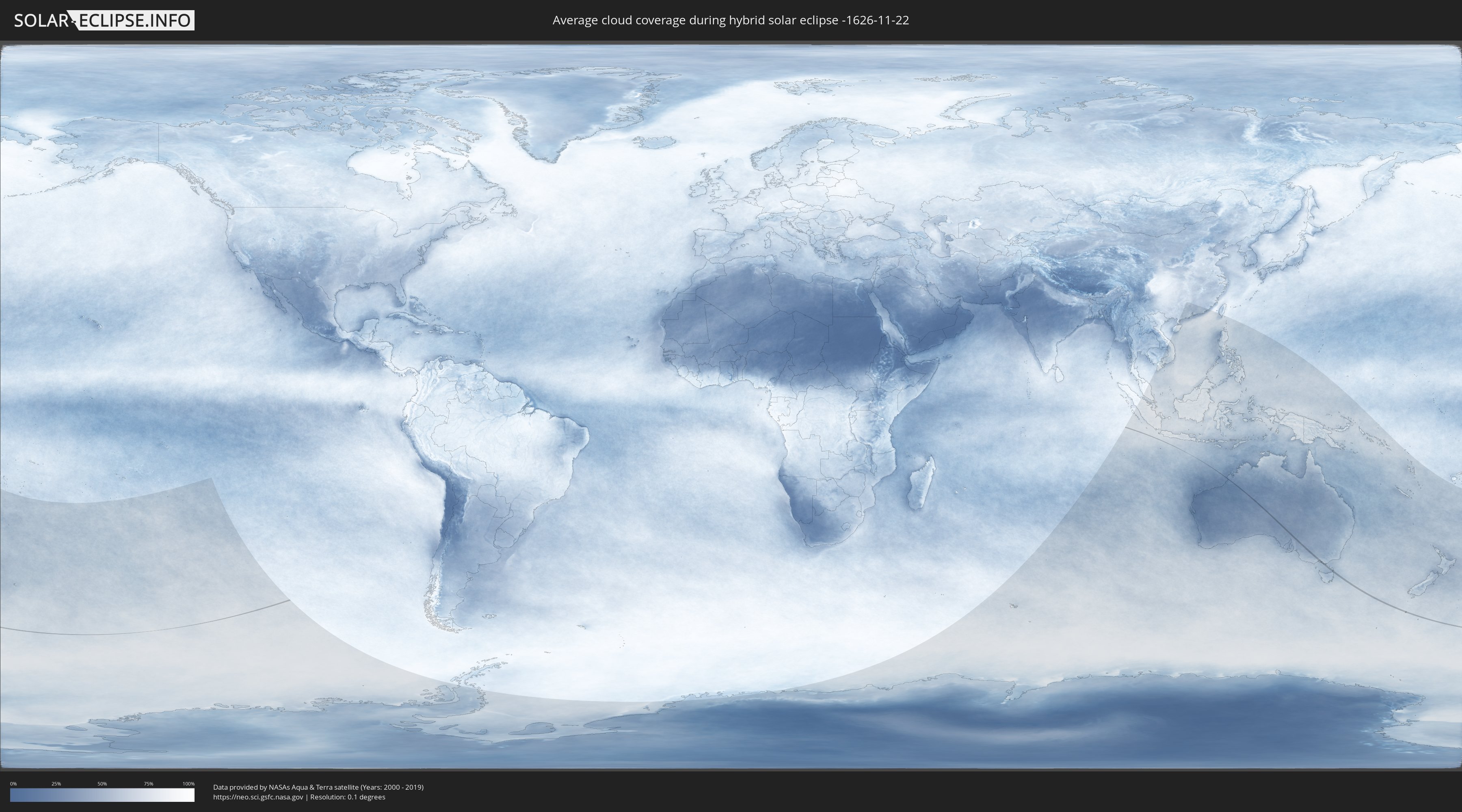
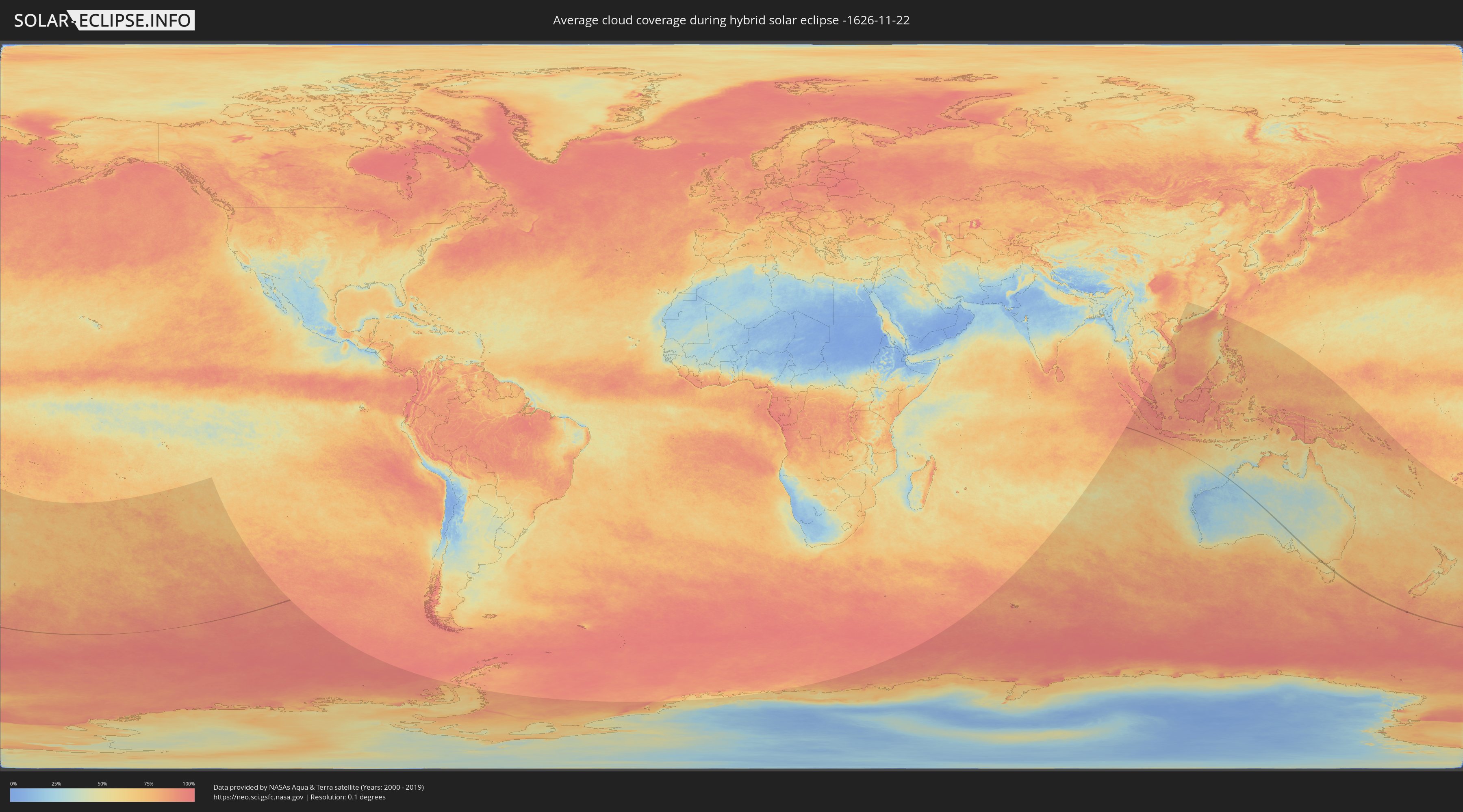
Wie wird das Wetter während der hybriden Sonnenfinsternis am 22.11.-1626?
Wo ist der beste Ort, um die hybride Sonnenfinsternis vom 22.11.-1626 zu beobachten?
Die folgenden Karten zeigen die durchschnittliche Bewölkung für den Tag, an dem die hybride Sonnenfinsternis
stattfindet. Mit Hilfe der Karten lässt sich der Ort entlang des Finsternispfades eingrenzen,
der die besten Aussichen auf einen klaren wolkenfreien Himmel bietet.
Trotzdem muss man immer lokale Gegenenheiten beachten und sollte sich genau über das Wetter an seinem
gewählten Beobachtungsort informieren.
Die Daten stammen von den beiden NASA-Satelliten
AQUA und TERRA
und wurden über einen Zeitraum von 19 Jahren (2000 - 2019) gemittelt.
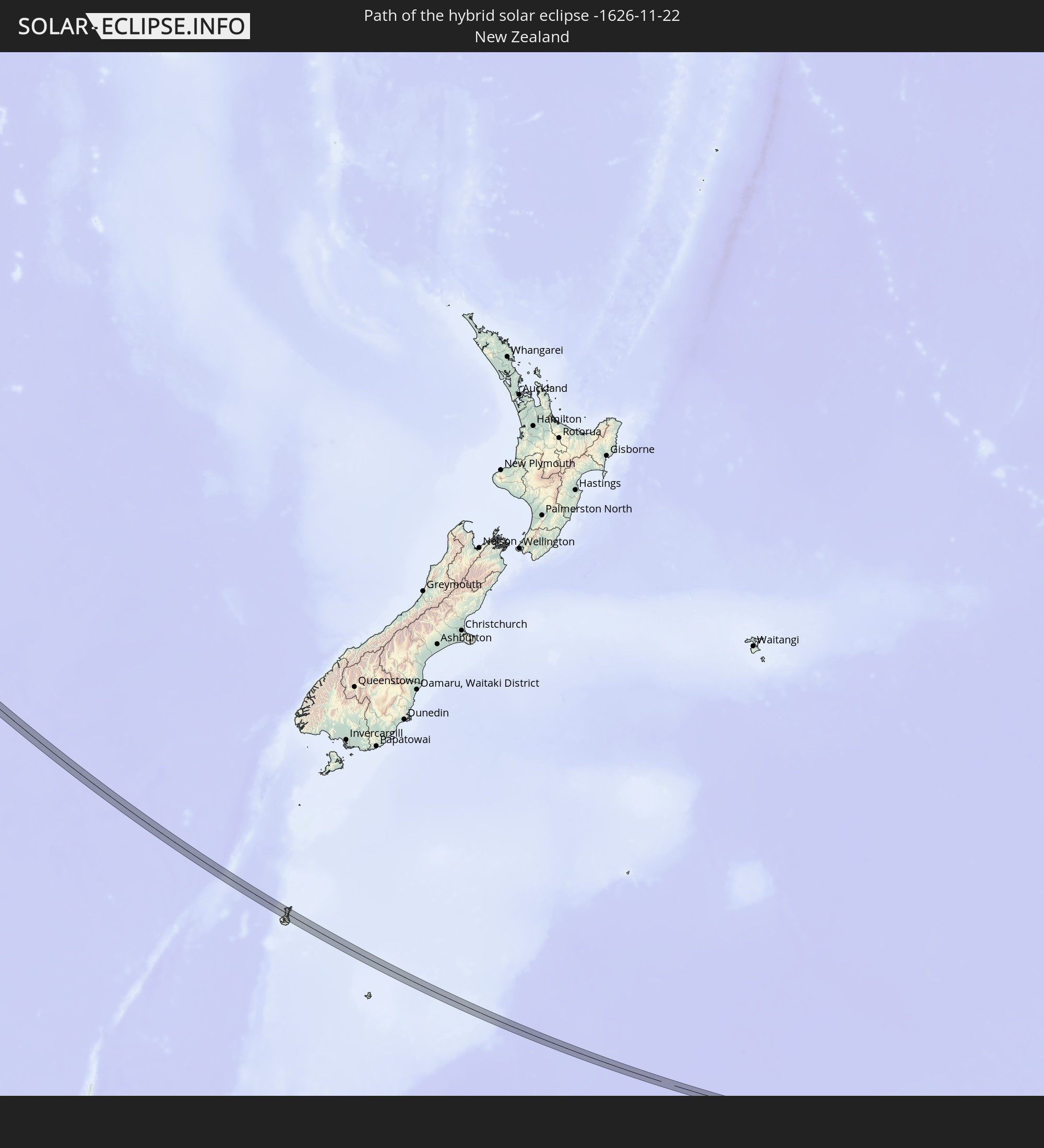
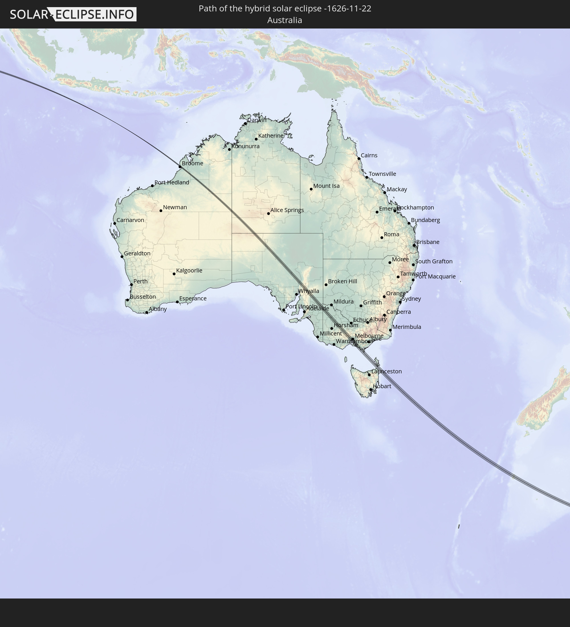
Detaillierte Länderkarten
 Neuseeland
 Australien
Orte im Finsternispfad
Die nachfolgene Tabelle zeigt Städte und Orte mit mehr als 5.000 Einwohnern, die sich im Finsternispfad befinden. Städte mit mehr als 100.000 Einwohnern sind dick gekennzeichnet. Mit einem Klick auf den Ort öffnet sich eine Detailkarte die die Lage des jeweiligen Ortes zusammen mit dem Verlauf der zentralen Finsternis präsentiert.
| Ort | Typ | Dauer der Verfinsterung | Ortszeit bei maximaler Verfinsterung | Entfernung zur Zentrallinie | Ø Bewölkung |
|
Maryborough, Victoria
|
total | - | 10:31:29 UTC+10:00 | 5 km | 57% |
|
Bacchus Marsh, Victoria
|
total | - | 10:33:36 UTC+10:00 | 7 km | 67% |
|
Wyndham Vale, Victoria
|
total | - | 10:34:04 UTC+10:00 | 13 km | 68% |
|
Melton West, Victoria
|
total | - | 10:33:48 UTC+10:00 | 1 km | 68% |
|
Melton South, Victoria
|
total | - | 10:33:51 UTC+10:00 | 0 km | 68% |
|
Melton, Victoria
|
total | - | 10:33:49 UTC+10:00 | 2 km | 68% |
|
Kurunjang, Victoria
|
total | - | 10:33:49 UTC+10:00 | 3 km | 68% |
|
Werribee, Victoria
|
total | - | 10:34:21 UTC+10:00 | 9 km | 66% |
|
Tarneit, Victoria
|
total | - | 10:34:17 UTC+10:00 | 7 km | 66% |
|
Hoppers Crossing, Victoria
|
total | - | 10:34:21 UTC+10:00 | 6 km | 66% |
|
Caroline Springs, Victoria
|
total | - | 10:34:08 UTC+10:00 | 7 km | 70% |
|
Hillside, Victoria
|
total | - | 10:34:03 UTC+10:00 | 12 km | 70% |
|
Truganina, Victoria
|
total | - | 10:34:18 UTC+10:00 | 3 km | 69% |
|
Point Cook, Victoria
|
total | - | 10:34:29 UTC+10:00 | 5 km | 64% |
|
Taylors Hill, Victoria
|
total | - | 10:34:06 UTC+10:00 | 11 km | 69% |
|
Sydenham, Victoria
|
total | - | 10:34:06 UTC+10:00 | 12 km | 69% |
|
Derrimut, Victoria
|
total | - | 10:34:17 UTC+10:00 | 6 km | 69% |
|
Delahey, Victoria
|
total | - | 10:34:09 UTC+10:00 | 12 km | 69% |
|
Deer Park, Victoria
|
total | - | 10:34:15 UTC+10:00 | 9 km | 69% |
|
Altona Meadows, Victoria
|
total | - | 10:34:28 UTC+10:00 | 1 km | 64% |
|
Taylors Lakes, Victoria
|
total | - | 10:34:07 UTC+10:00 | 14 km | 69% |
|
Cairnlea, Victoria
|
total | - | 10:34:14 UTC+10:00 | 9 km | 69% |
|
Saint Albans, Victoria
|
total | - | 10:34:12 UTC+10:00 | 12 km | 69% |
|
St Albans, Victoria
|
total | - | 10:34:14 UTC+10:00 | 11 km | 69% |
|
Keilor Downs, Victoria
|
total | - | 10:34:12 UTC+10:00 | 13 km | 69% |
|
Sunshine West, Victoria
|
total | - | 10:34:20 UTC+10:00 | 9 km | 69% |
|
Sunshine North, Victoria
|
total | - | 10:34:19 UTC+10:00 | 11 km | 69% |
|
Altona, Victoria
|
total | - | 10:34:30 UTC+10:00 | 4 km | 64% |
|
Keilor, Victoria
|
total | - | 10:34:13 UTC+10:00 | 16 km | 69% |
|
Altona North, Victoria
|
total | - | 10:34:28 UTC+10:00 | 7 km | 69% |
|
Braybrook, Victoria
|
total | - | 10:34:23 UTC+10:00 | 12 km | 67% |
|
Keilor East, Victoria
|
total | - | 10:34:18 UTC+10:00 | 16 km | 67% |
|
Maidstone, Victoria
|
total | - | 10:34:24 UTC+10:00 | 13 km | 67% |
|
West Footscray, Victoria
|
total | - | 10:34:26 UTC+10:00 | 12 km | 67% |
|
Maribyrnong, Victoria
|
total | - | 10:34:25 UTC+10:00 | 14 km | 67% |
|
Newport, Victoria
|
total | - | 10:34:32 UTC+10:00 | 9 km | 67% |
|
Williamstown, Victoria
|
total | - | 10:34:34 UTC+10:00 | 9 km | 63% |
|
Yarraville, Victoria
|
total | - | 10:34:30 UTC+10:00 | 12 km | 67% |
|
Footscray, Victoria
|
total | - | 10:34:28 UTC+10:00 | 14 km | 67% |
|
Moonee Ponds, Victoria
|
total | - | 10:34:26 UTC+10:00 | 17 km | 67% |
|
Essendon, Victoria
|
total | - | 10:34:26 UTC+10:00 | 17 km | 67% |
|
Ascot Vale, Victoria
|
total | - | 10:34:28 UTC+10:00 | 16 km | 67% |
|
Flemington, Victoria
|
total | - | 10:34:29 UTC+10:00 | 16 km | 67% |
|
Kensington, Victoria
|
total | - | 10:34:29 UTC+10:00 | 17 km | 67% |
|
Port Melbourne, Victoria
|
total | - | 10:34:36 UTC+10:00 | 13 km | 67% |
|
North Melbourne, Victoria
|
total | - | 10:34:32 UTC+10:00 | 16 km | 67% |
|
Docklands, Victoria
|
total | - | 10:34:34 UTC+10:00 | 16 km | 65% |
|
Melbourne, Victoria
|
total | - | 10:34:35 UTC+10:00 | 17 km | 65% |
|
Southbank, Victoria
|
total | - | 10:34:36 UTC+10:00 | 16 km | 65% |
|
South Melbourne, Victoria
|
total | - | 10:34:37 UTC+10:00 | 15 km | 65% |
|
Saint Kilda, Victoria
|
total | - | 10:34:42 UTC+10:00 | 14 km | 64% |
|
Elwood, Victoria
|
total | - | 10:34:44 UTC+10:00 | 13 km | 64% |
|
Windsor, Victoria
|
total | - | 10:34:42 UTC+10:00 | 15 km | 64% |
|
Balaclava, Victoria
|
total | - | 10:34:44 UTC+10:00 | 15 km | 64% |
|
Hampton, Victoria
|
total | - | 10:34:53 UTC+10:00 | 9 km | 62% |
|
Albert Park, Victoria
|
total | - | 10:34:40 UTC+10:00 | 17 km | 65% |
|
St Kilda East, Victoria
|
total | - | 10:34:44 UTC+10:00 | 15 km | 64% |
|
Elsternwick, Victoria
|
total | - | 10:34:46 UTC+10:00 | 14 km | 64% |
|
Black Rock, Victoria
|
total | - | 10:34:57 UTC+10:00 | 8 km | 62% |
|
Mount Martha, Victoria
|
total | - | 10:35:31 UTC+10:00 | 14 km | 61% |
|
Brighton East, Victoria
|
total | - | 10:34:49 UTC+10:00 | 13 km | 64% |
|
Caulfield North, Victoria
|
total | - | 10:34:46 UTC+10:00 | 16 km | 64% |
|
Caulfield North, Victoria
|
total | - | 10:34:47 UTC+10:00 | 16 km | 64% |
|
Caulfield South, Victoria
|
total | - | 10:34:49 UTC+10:00 | 14 km | 64% |
|
Ormond, Victoria
|
total | - | 10:34:50 UTC+10:00 | 15 km | 64% |
|
Beaumaris, Victoria
|
total | - | 10:35:00 UTC+10:00 | 8 km | 62% |
|
Moorabbin, Victoria
|
total | - | 10:34:55 UTC+10:00 | 12 km | 64% |
|
Bentleigh, Victoria
|
total | - | 10:34:53 UTC+10:00 | 13 km | 64% |
|
Mornington, Victoria
|
total | - | 10:35:27 UTC+10:00 | 9 km | 60% |
|
Malvern East, Victoria
|
total | - | 10:34:48 UTC+10:00 | 17 km | 64% |
|
Cheltenham, Victoria
|
total | - | 10:34:59 UTC+10:00 | 10 km | 62% |
|
Highett, Victoria
|
total | - | 10:34:57 UTC+10:00 | 12 km | 65% |
|
McKinnon, Victoria
|
total | - | 10:34:54 UTC+10:00 | 14 km | 65% |
|
Parkdale, Victoria
|
total | - | 10:35:02 UTC+10:00 | 10 km | 65% |
|
Murrumbeena, Victoria
|
total | - | 10:34:53 UTC+10:00 | 17 km | 65% |
|
Mentone, Victoria
|
total | - | 10:35:02 UTC+10:00 | 10 km | 65% |
|
Mount Eliza, Victoria
|
total | - | 10:35:27 UTC+10:00 | 4 km | 60% |
|
Mordialloc, Victoria
|
total | - | 10:35:06 UTC+10:00 | 10 km | 65% |
|
Oakleigh South, Victoria
|
total | - | 10:34:58 UTC+10:00 | 16 km | 65% |
|
Aspendale, Victoria
|
total | - | 10:35:11 UTC+10:00 | 9 km | 65% |
|
Edithvale, Victoria
|
total | - | 10:35:12 UTC+10:00 | 9 km | 65% |
|
Clayton South, Victoria
|
total | - | 10:35:01 UTC+10:00 | 17 km | 65% |
|
Clarinda, Victoria
|
total | - | 10:35:01 UTC+10:00 | 17 km | 65% |
|
Chelsea, Victoria
|
total | - | 10:35:14 UTC+10:00 | 8 km | 63% |
|
Aspendale Gardens, Victoria
|
total | - | 10:35:11 UTC+10:00 | 11 km | 65% |
|
Bonbeach, Victoria
|
total | - | 10:35:16 UTC+10:00 | 8 km | 63% |
|
Frankston, Victoria
|
total | - | 10:35:25 UTC+10:00 | 2 km | 63% |
|
Chelsea Heights, Victoria
|
total | - | 10:35:14 UTC+10:00 | 11 km | 65% |
|
Seaford, Victoria
|
total | - | 10:35:21 UTC+10:00 | 6 km | 63% |
|
Frankston East, Victoria
|
total | - | 10:35:25 UTC+10:00 | 3 km | 63% |
|
Dingley Village, Victoria
|
total | - | 10:35:08 UTC+10:00 | 15 km | 65% |
|
Frankston South, Victoria
|
total | - | 10:35:29 UTC+10:00 | 1 km | 60% |
|
Patterson Lakes, Victoria
|
total | - | 10:35:19 UTC+10:00 | 9 km | 63% |
|
Frankston North, Victoria
|
total | - | 10:35:25 UTC+10:00 | 5 km | 63% |
|
Springvale South, Victoria
|
total | - | 10:35:07 UTC+10:00 | 17 km | 69% |
|
Langwarrin, Victoria
|
total | - | 10:35:31 UTC+10:00 | 3 km | 63% |
|
Somerville, Victoria
|
total | - | 10:35:37 UTC+10:00 | 1 km | 63% |
|
Carrum Downs, Victoria
|
total | - | 10:35:24 UTC+10:00 | 8 km | 64% |
|
Keysborough, Victoria
|
total | - | 10:35:12 UTC+10:00 | 17 km | 69% |
|
Hastings, Victoria
|
total | - | 10:35:48 UTC+10:00 | 6 km | 62% |
|
Skye, Victoria
|
total | - | 10:35:28 UTC+10:00 | 11 km | 64% |
|
Phillip Island, Victoria
|
total | - | 10:36:13 UTC+10:00 | 17 km | 62% |
|
Lynbrook, Victoria
|
total | - | 10:35:26 UTC+10:00 | 17 km | 66% |
|
Cranbourne West, Victoria
|
total | - | 10:35:32 UTC+10:00 | 15 km | 66% |
|
Cranbourne North, Victoria
|
total | - | 10:35:31 UTC+10:00 | 16 km | 66% |
|
Cranbourne, Victoria
|
total | - | 10:35:35 UTC+10:00 | 14 km | 66% |
|
Cranbourne, Victoria
|
total | - | 10:35:33 UTC+10:00 | 15 km | 66% |
|
Cranbourne East, Victoria
|
total | - | 10:35:36 UTC+10:00 | 15 km | 66% |
|
North Wonthaggi, Victoria
|
total | - | 10:36:56 UTC+10:00 | 3 km | 63% |