Totale Sonnenfinsternis vom 05.06.-1822
| Wochentag: | Mittwoch |
| Maximale Dauer der Verfinsterung: | 05m20s |
| Maximale Breite des Finsternispfades: | 246 km |
| Saroszyklus: | 8 |
| Bedeckungsgrad: | 100% |
| Magnitude: | 1.0686 |
| Gamma: | 0.4148 |
Wo kann man die Sonnenfinsternis vom 05.06.-1822 sehen?
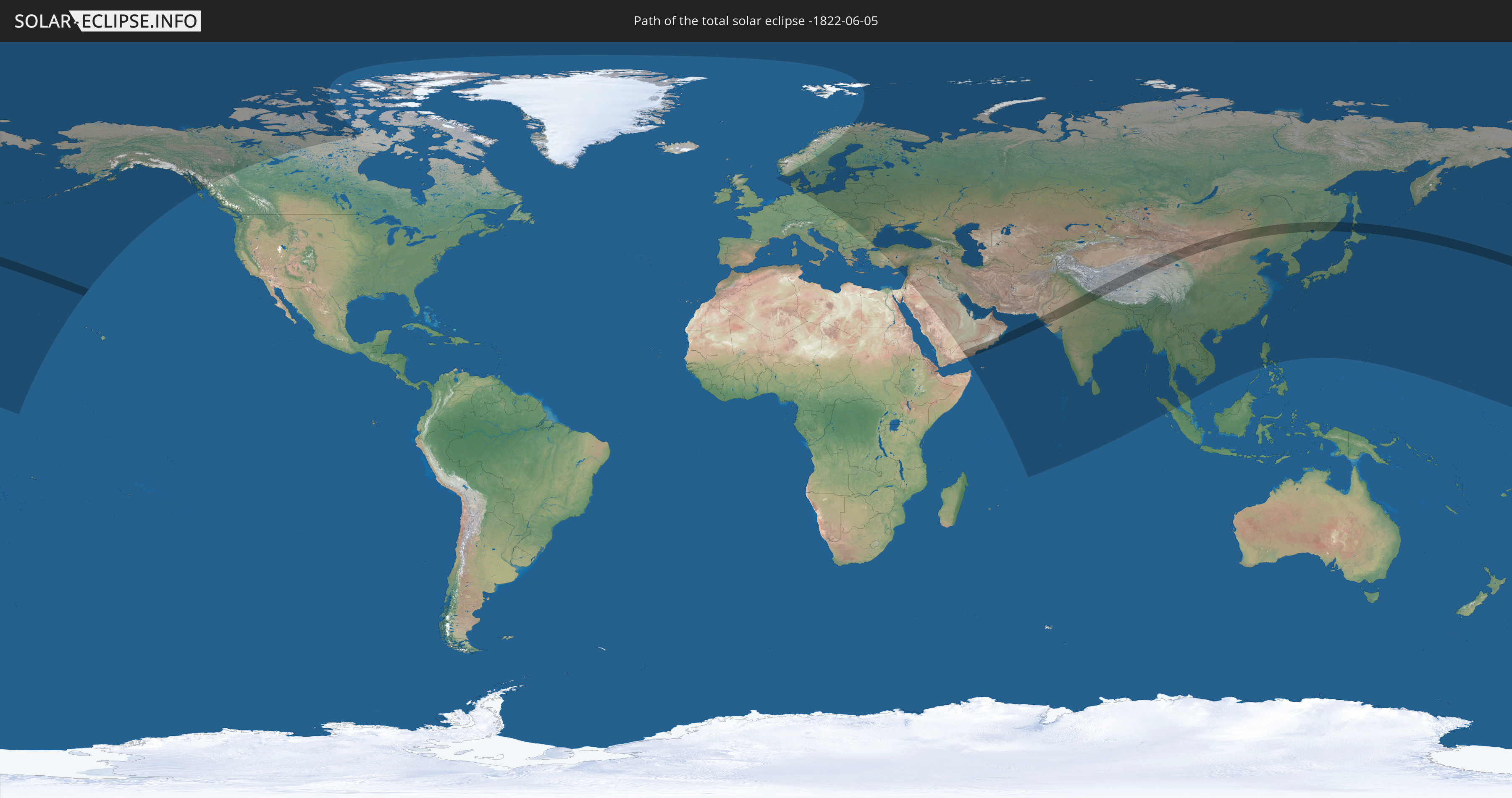
Die Sonnenfinsternis am 05.06.-1822 kann man in 71 Ländern als partielle Sonnenfinsternis beobachten.
Der Finsternispfad verläuft durch 9 Länder. Nur in diesen Ländern ist sie als totale Sonnenfinsternis zu sehen.
In den folgenden Ländern ist die Sonnenfinsternis total zu sehen
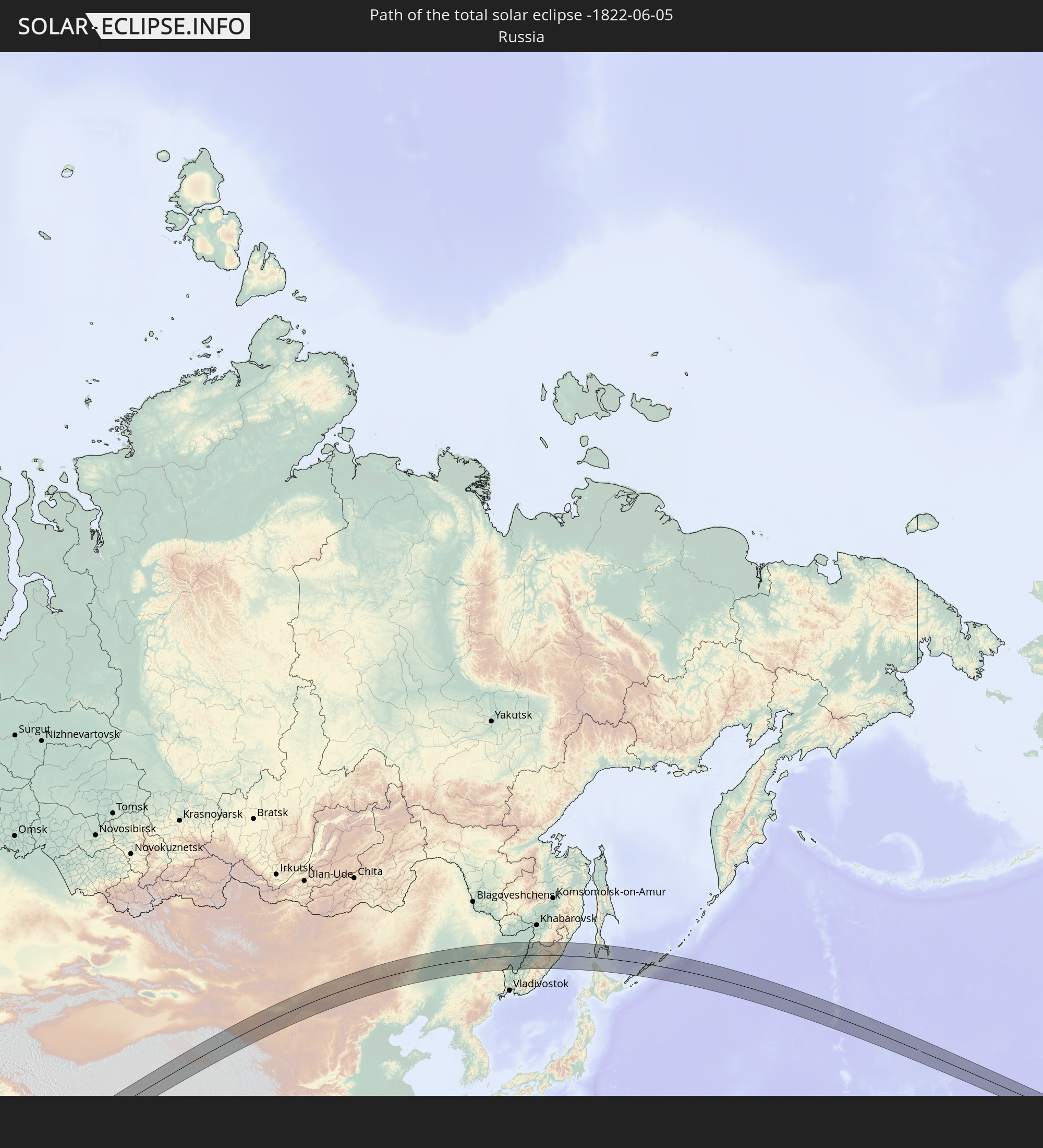 Russland
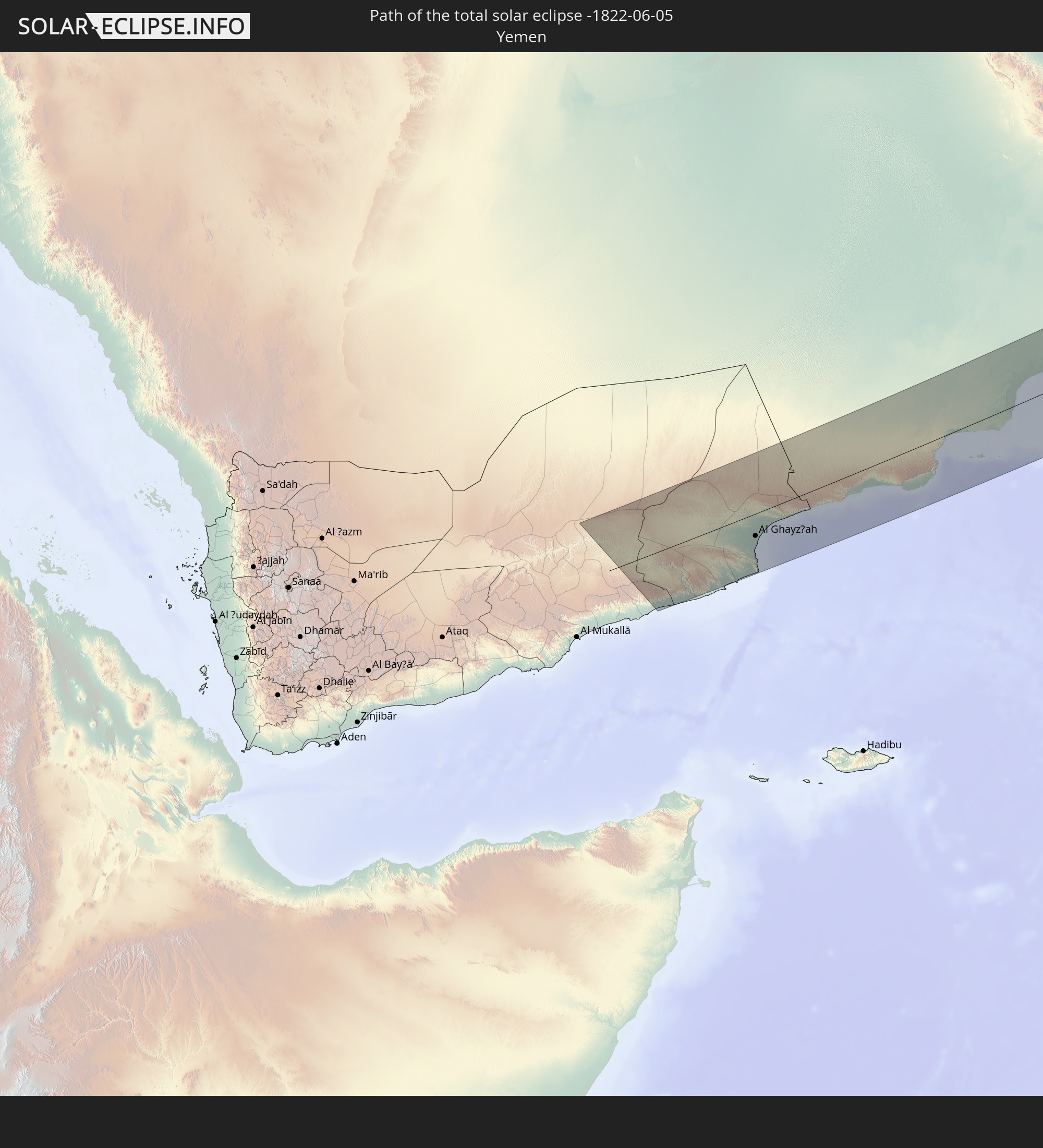 Jemen
Jemen
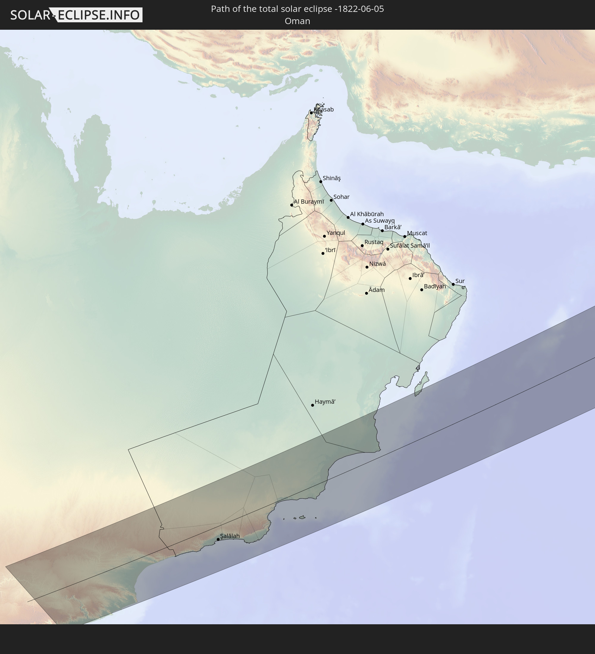 Oman
Oman
 Pakistan
 Indien
 Volksrepublik China
 Nepal
Nepal
 Mongolei
 Japan
Japan
In den folgenden Ländern ist die Sonnenfinsternis partiell zu sehen
 Russland
 Vereinigte Staaten
 United States Minor Outlying Islands
 Kanada
 Spitzbergen
 Norwegen
 Deutschland
 Dänemark
 Schweden
 Tschechien
 Polen
Polen
 Ungarn
 Slowakei
 Åland Islands
 Rumänien
 Finnland
 Litauen
 Lettland
 Estland
 Ukraine
 Bulgarien
 Weißrussland
 Türkei
 Moldawien
 Saudi-Arabien
 Jordanien
 Libanon
 Syrien
 Irak
Irak
 Georgien
 Jemen
Jemen
 Armenien
 Iran
Iran
 Aserbaidschan
 Kasachstan
 Kuwait
 Bahrain
 Katar
Katar
 Vereinigte Arabische Emirate
 Oman
Oman
 Turkmenistan
 Usbekistan
 Afghanistan
 Pakistan
 Tadschikistan
 Indien
 Kirgisistan
 Britisches Territorium im Indischen Ozean
 Malediven
 Volksrepublik China
 Sri Lanka
 Nepal
Nepal
 Mongolei
 Bangladesch
 Bhutan
 Myanmar
 Indonesien
 Thailand
 Malaysia
 Laos
Laos
 Vietnam
 Kambodscha
 Macau
Macau
 Hongkong
 Taiwan
 Philippinen
 Japan
Japan
 Nordkorea
 Südkorea
 Nördliche Marianen
 Marshallinseln
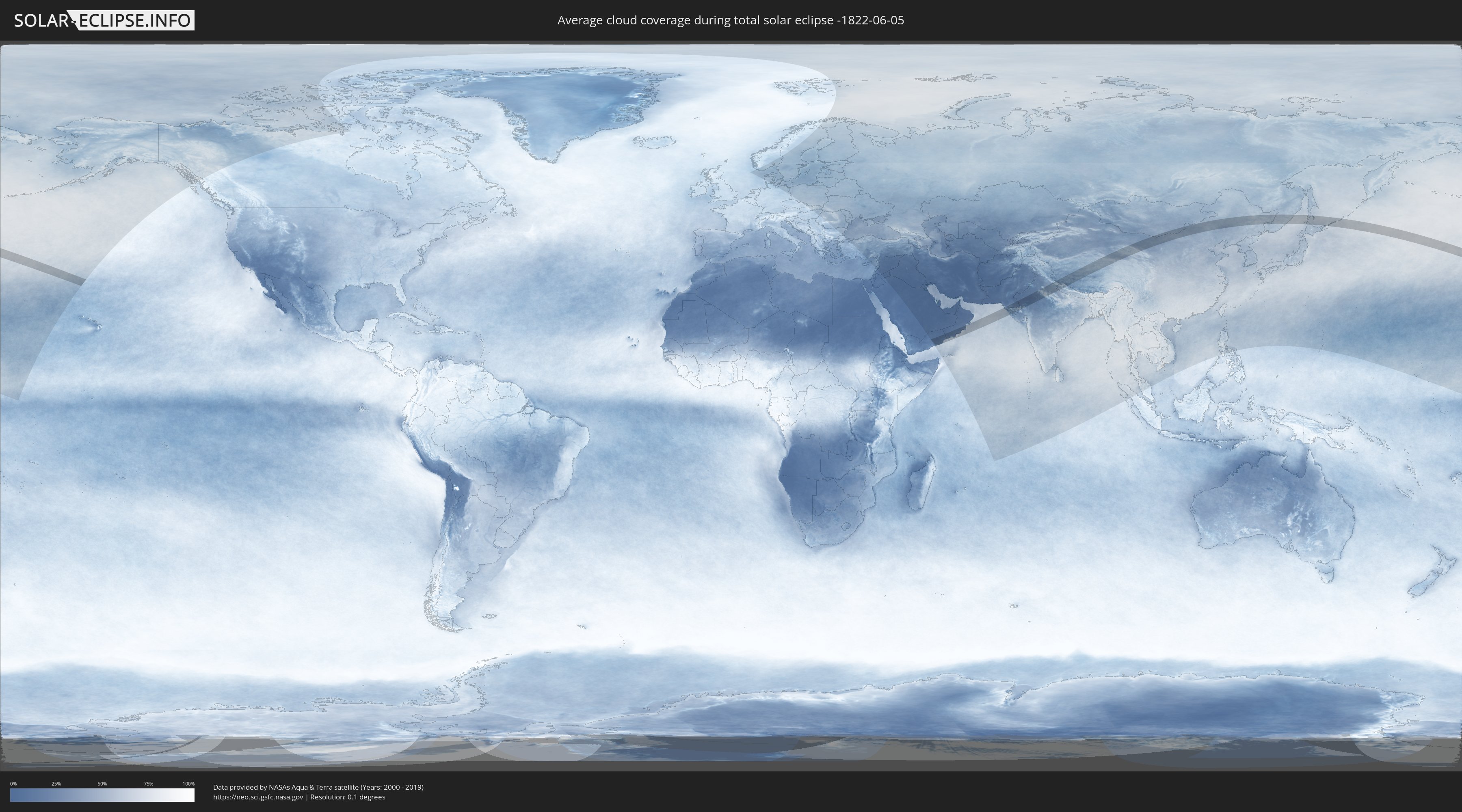
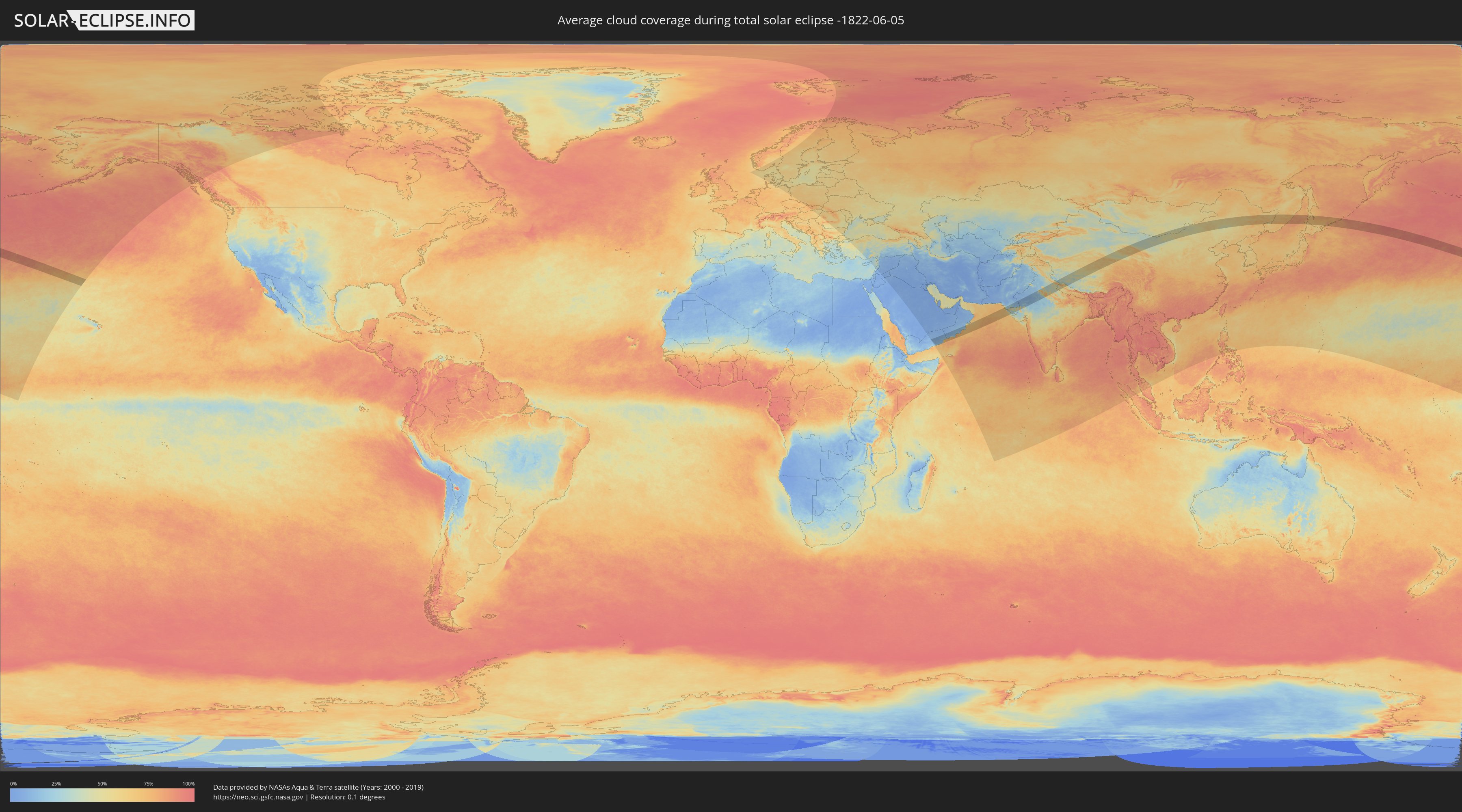
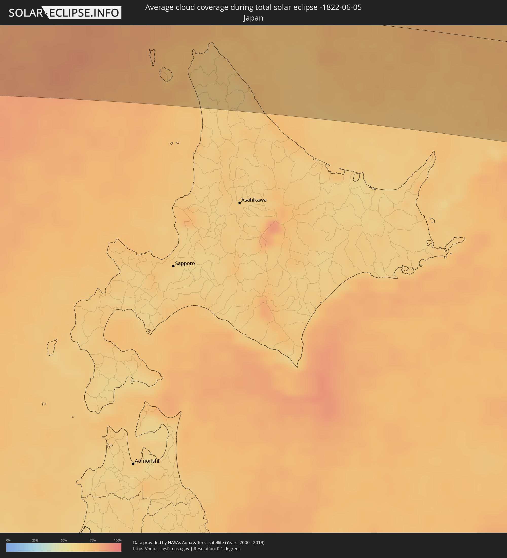
Wie wird das Wetter während der totalen Sonnenfinsternis am 05.06.-1822?
Wo ist der beste Ort, um die totale Sonnenfinsternis vom 05.06.-1822 zu beobachten?
Die folgenden Karten zeigen die durchschnittliche Bewölkung für den Tag, an dem die totale Sonnenfinsternis
stattfindet. Mit Hilfe der Karten lässt sich der Ort entlang des Finsternispfades eingrenzen,
der die besten Aussichen auf einen klaren wolkenfreien Himmel bietet.
Trotzdem muss man immer lokale Gegenenheiten beachten und sollte sich genau über das Wetter an seinem
gewählten Beobachtungsort informieren.
Die Daten stammen von den beiden NASA-Satelliten
AQUA und TERRA
und wurden über einen Zeitraum von 19 Jahren (2000 - 2019) gemittelt.
Detaillierte Länderkarten
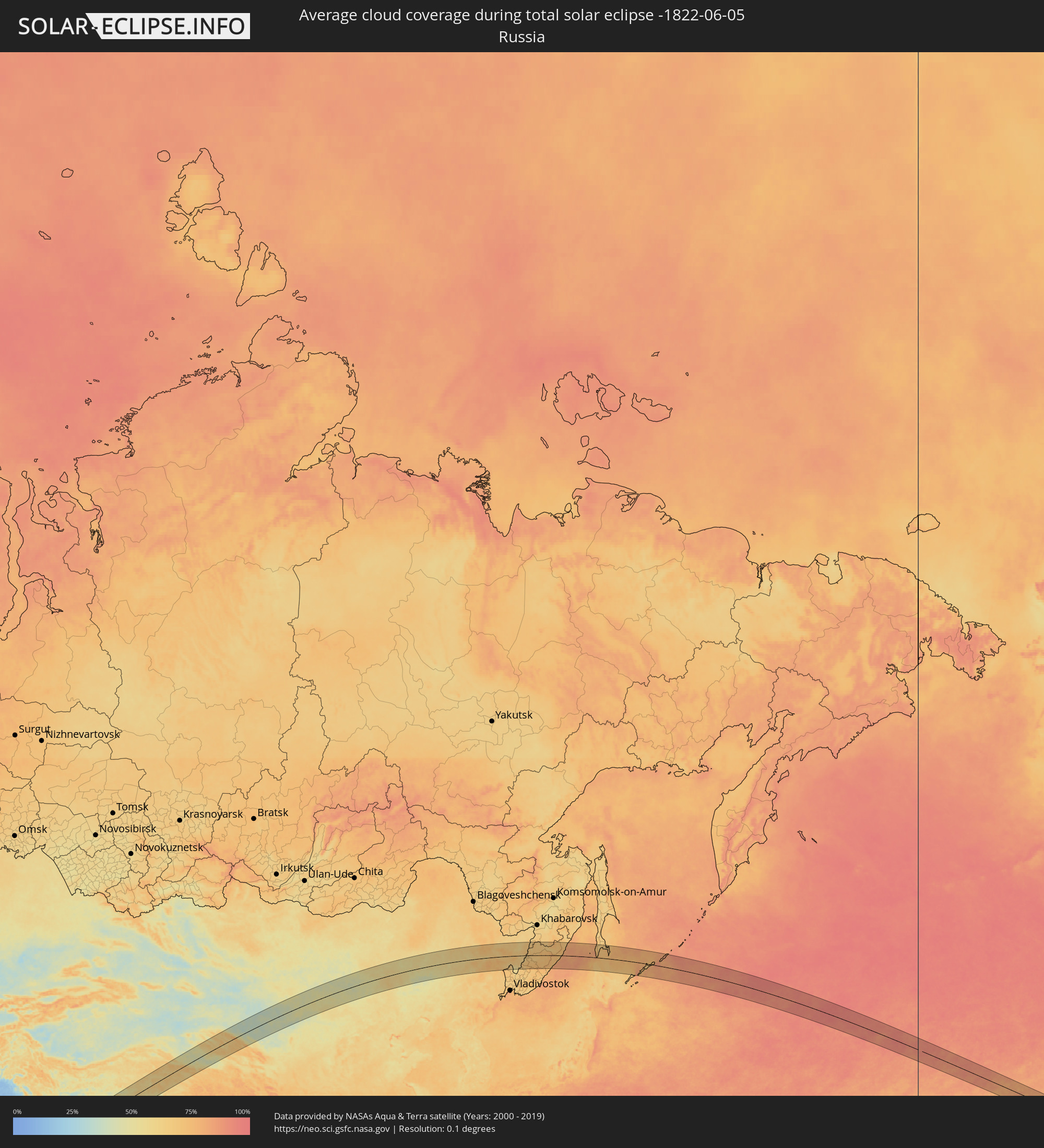 Russland
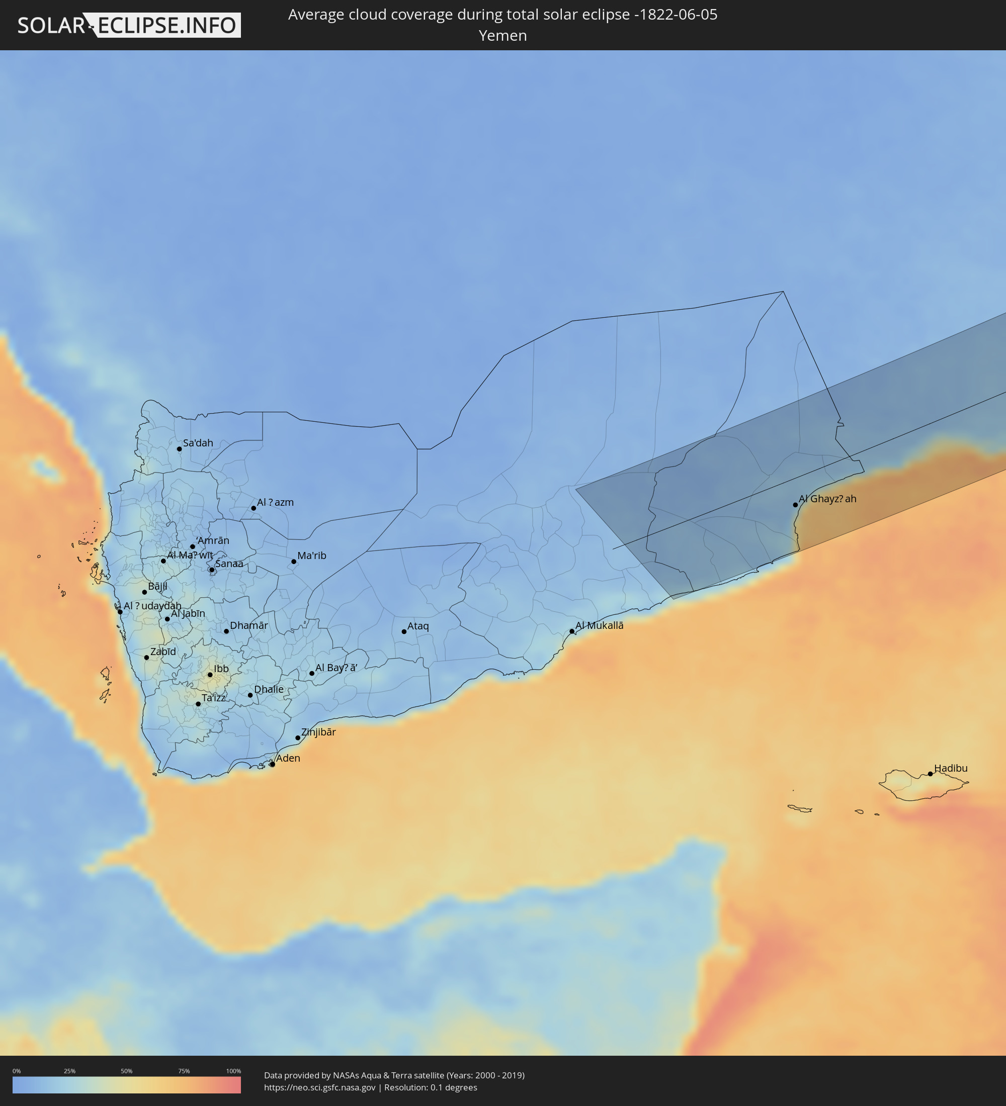 Jemen
Jemen
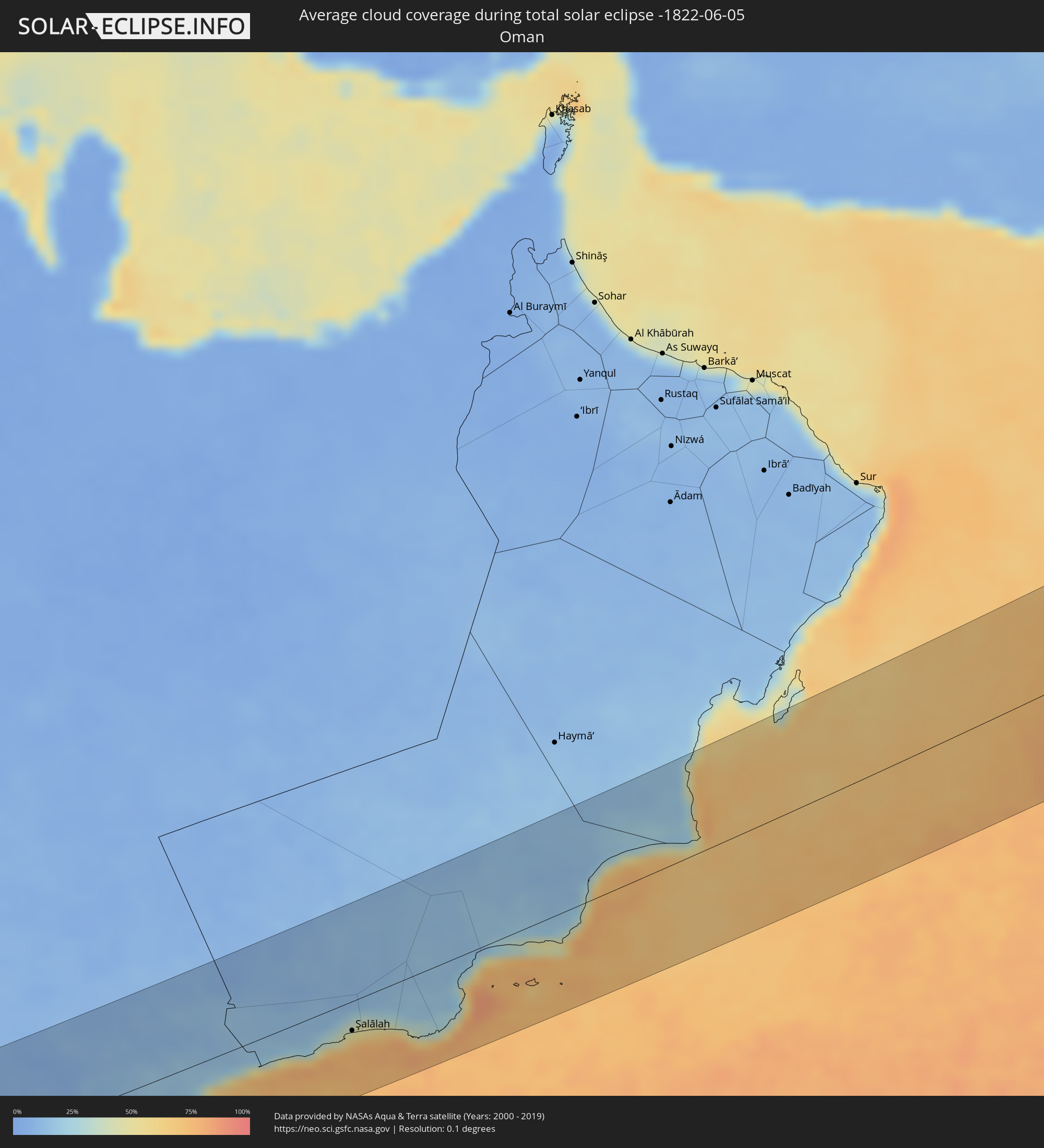 Oman
Oman
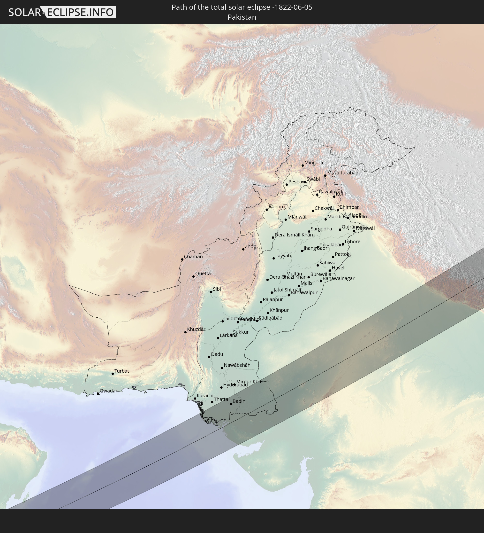
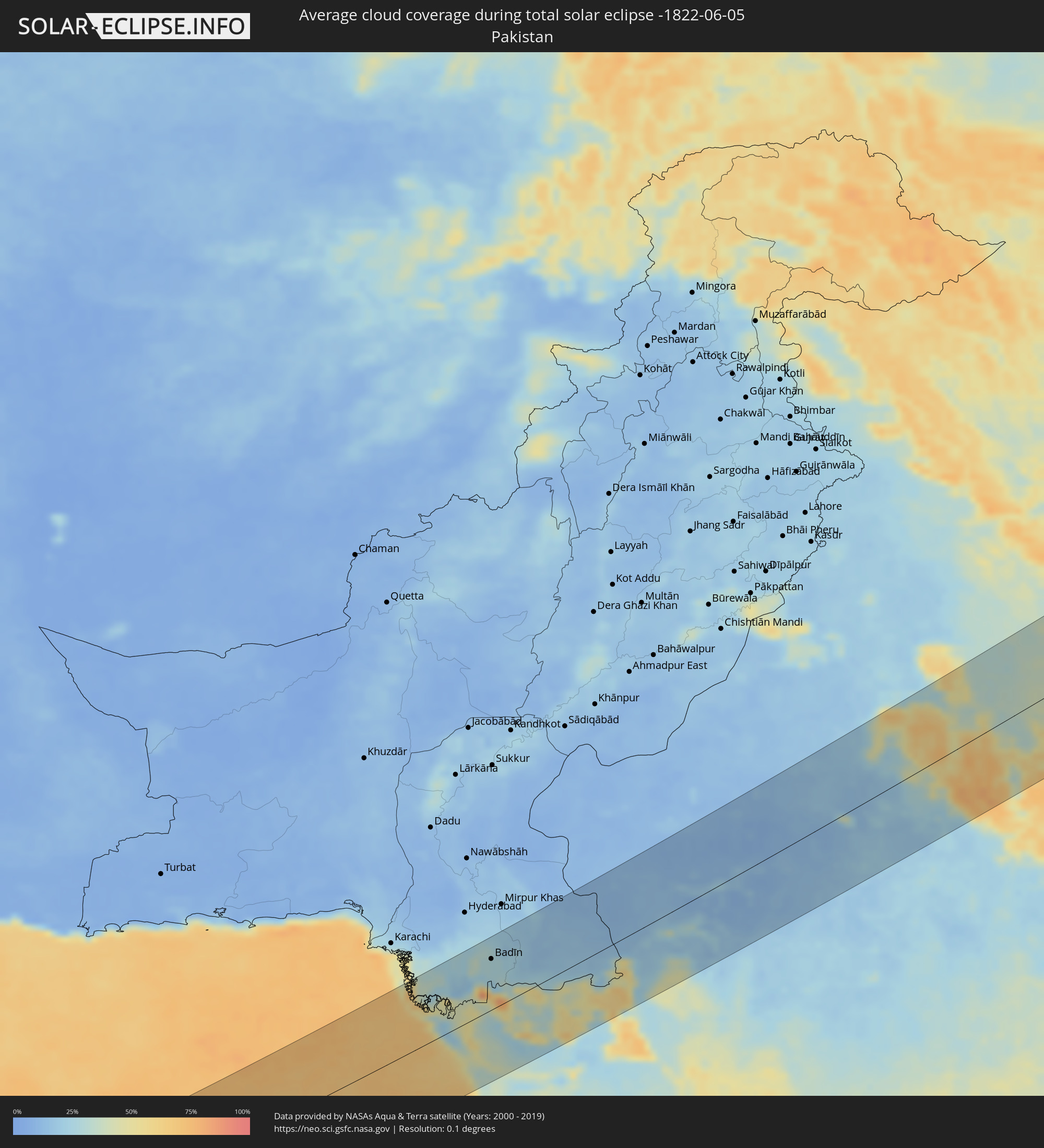 Pakistan
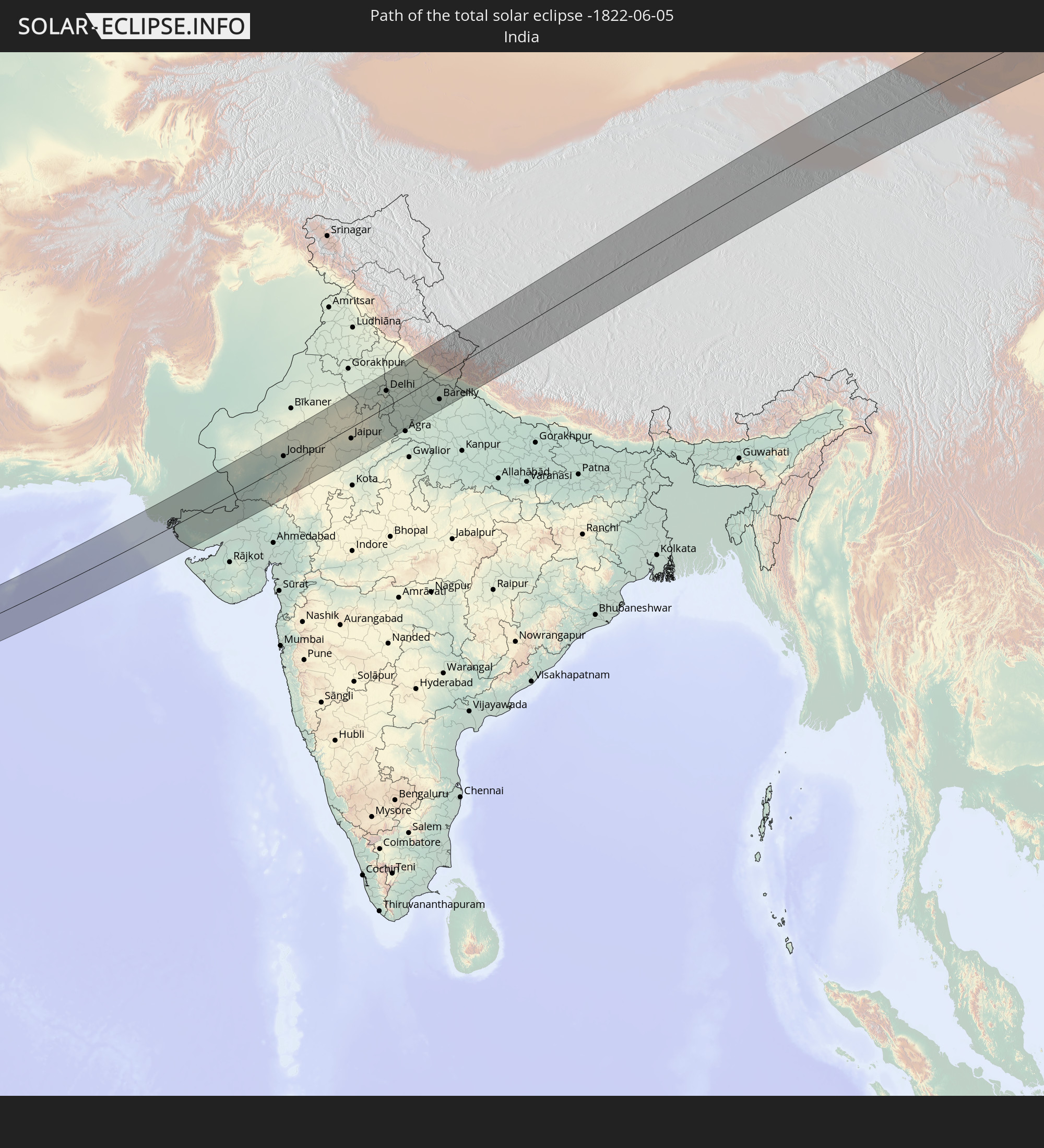
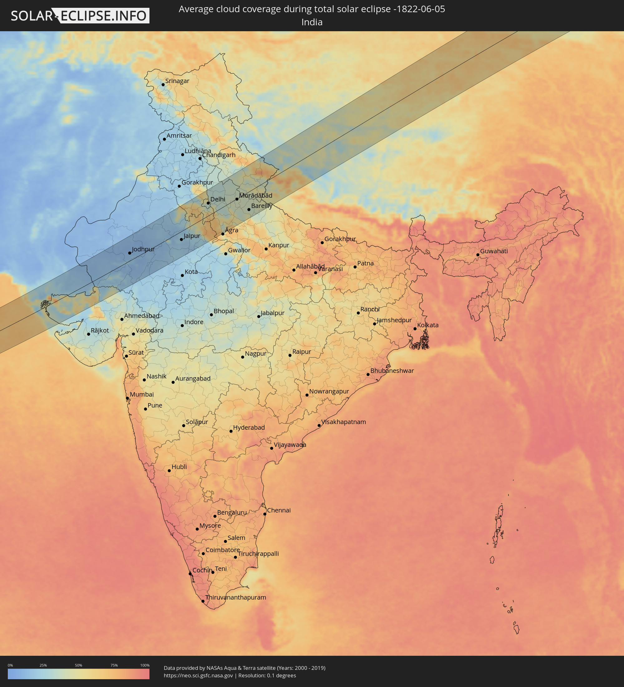 Indien
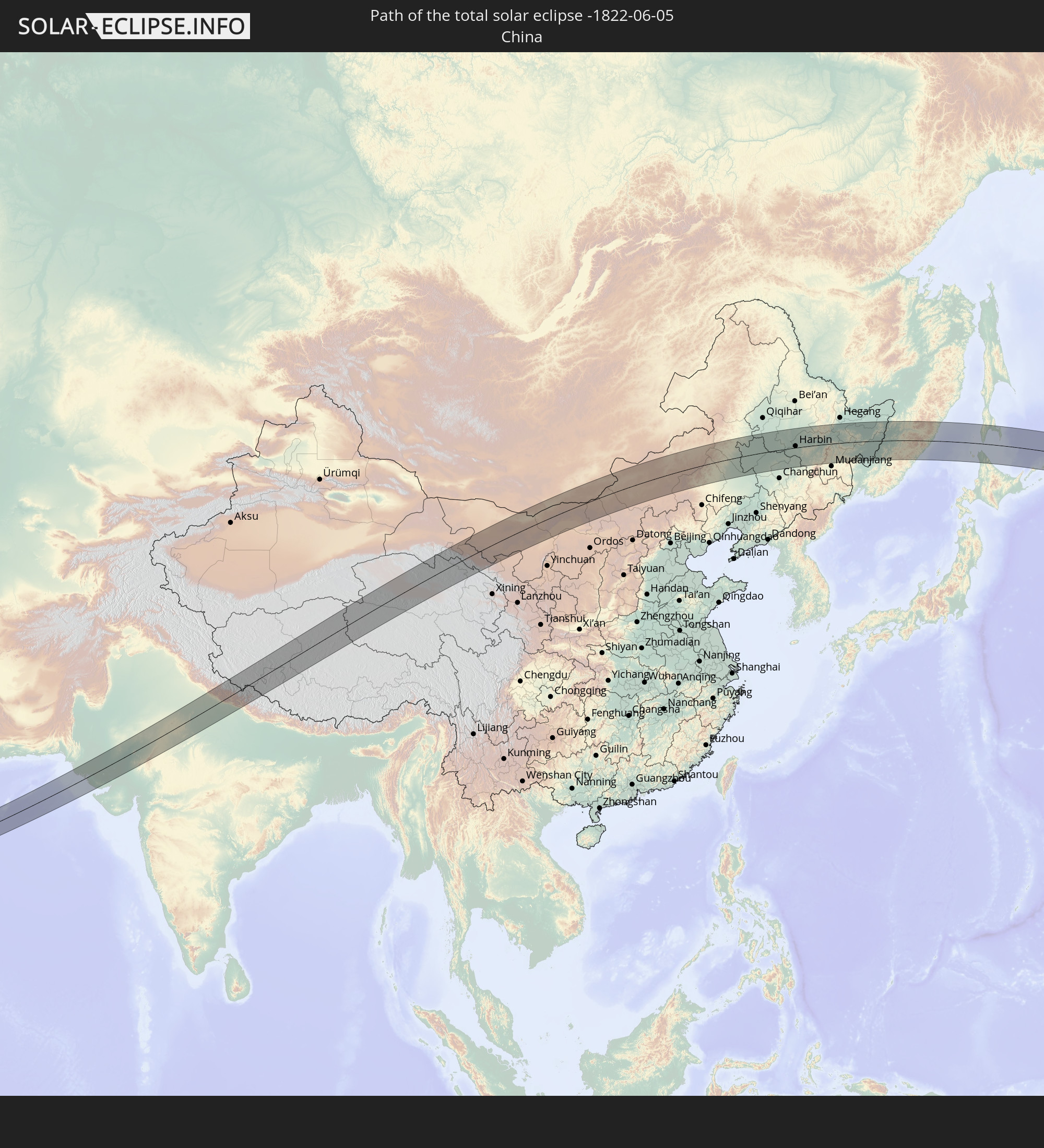
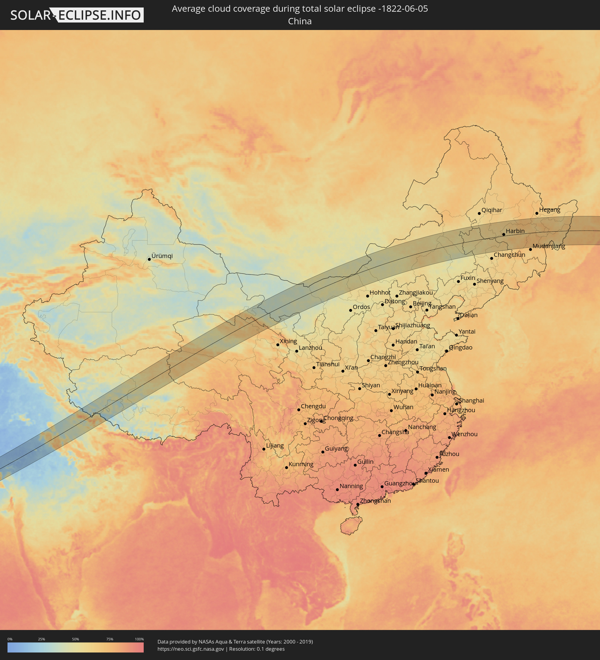 Volksrepublik China
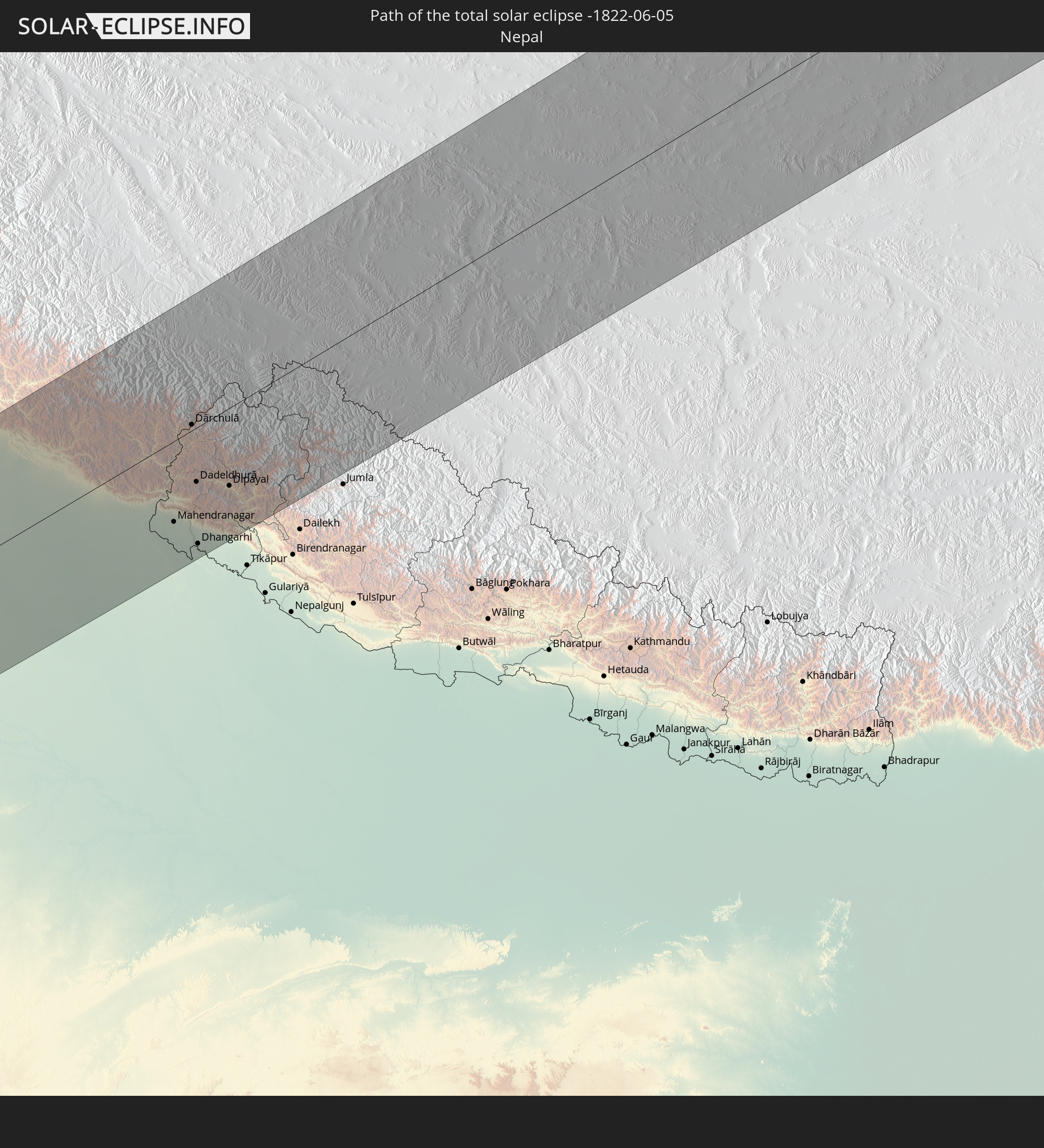
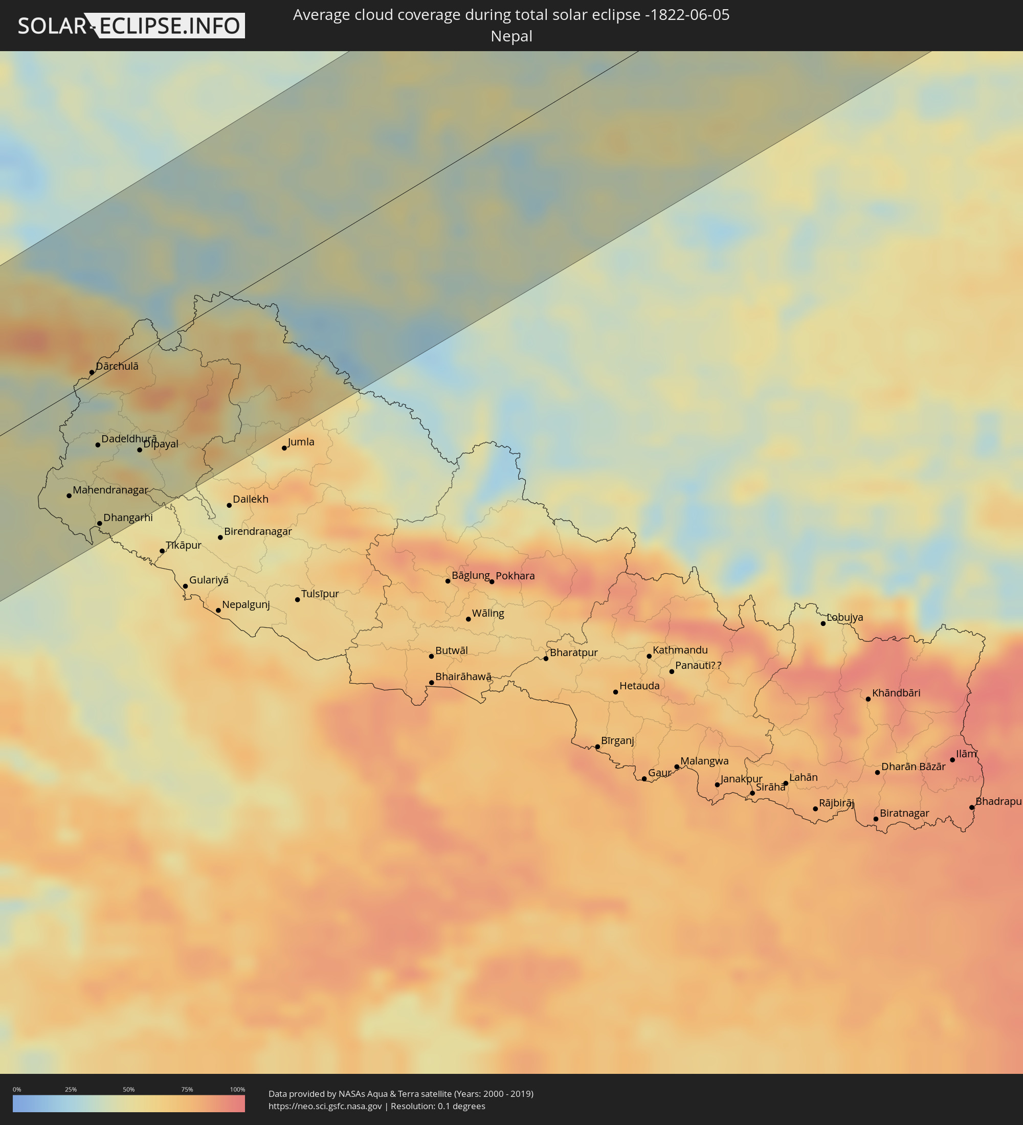 Nepal
Nepal
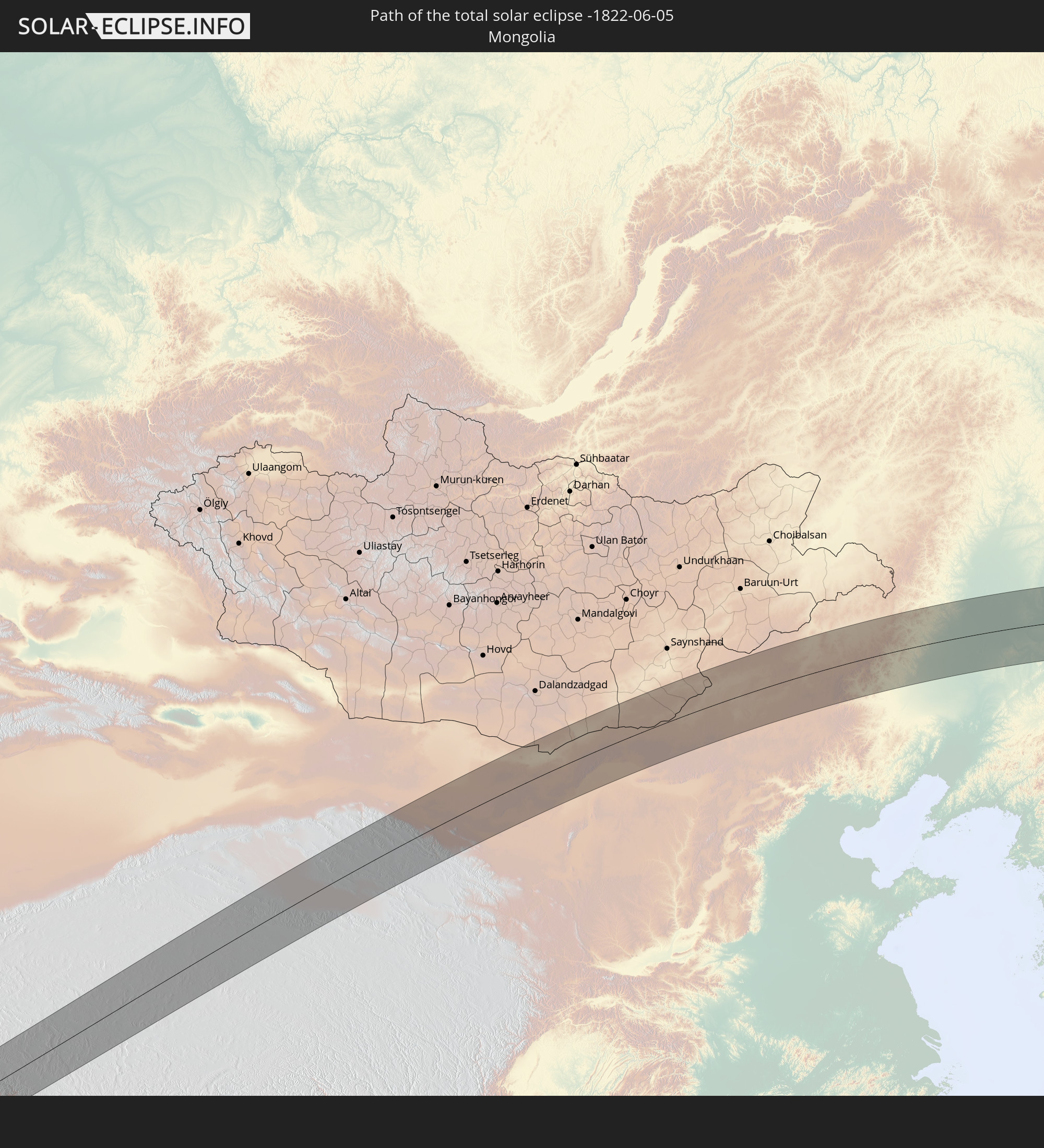
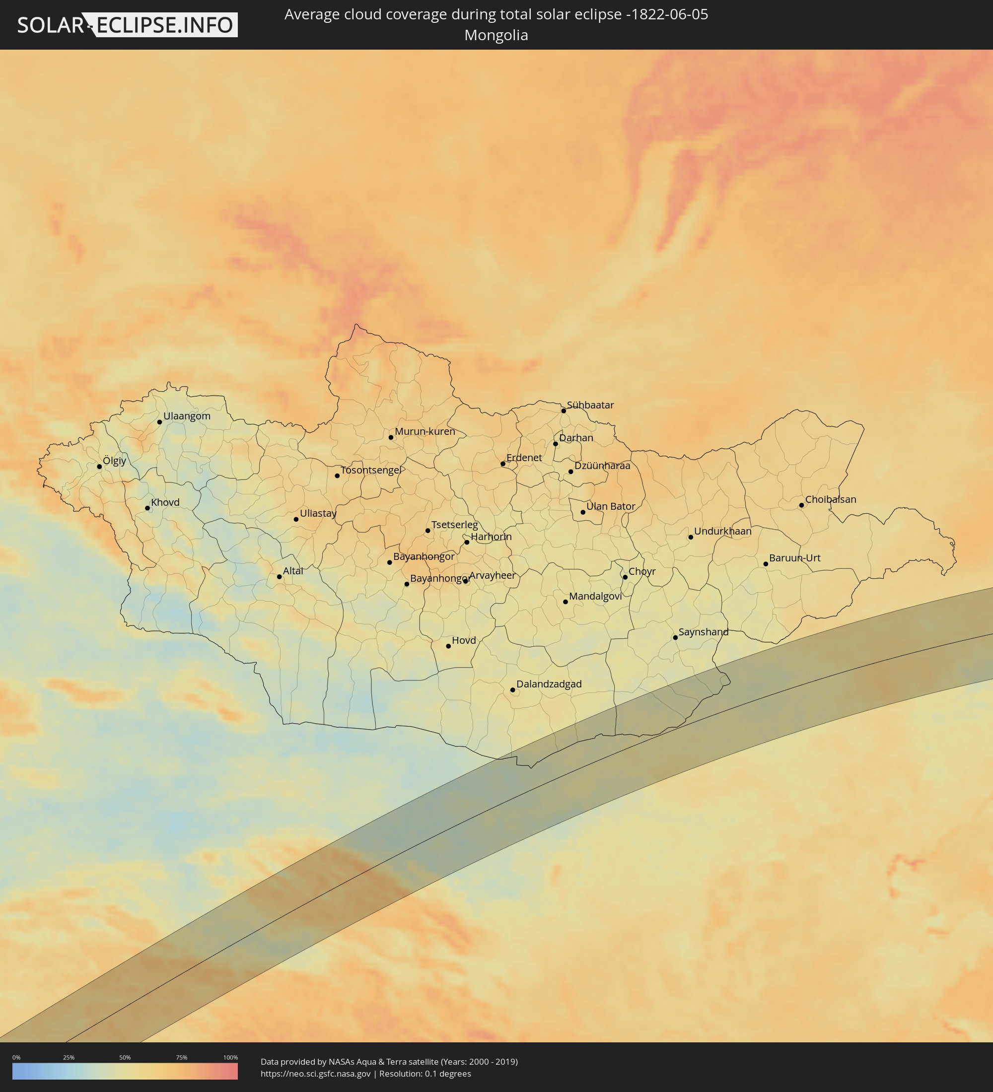 Mongolei
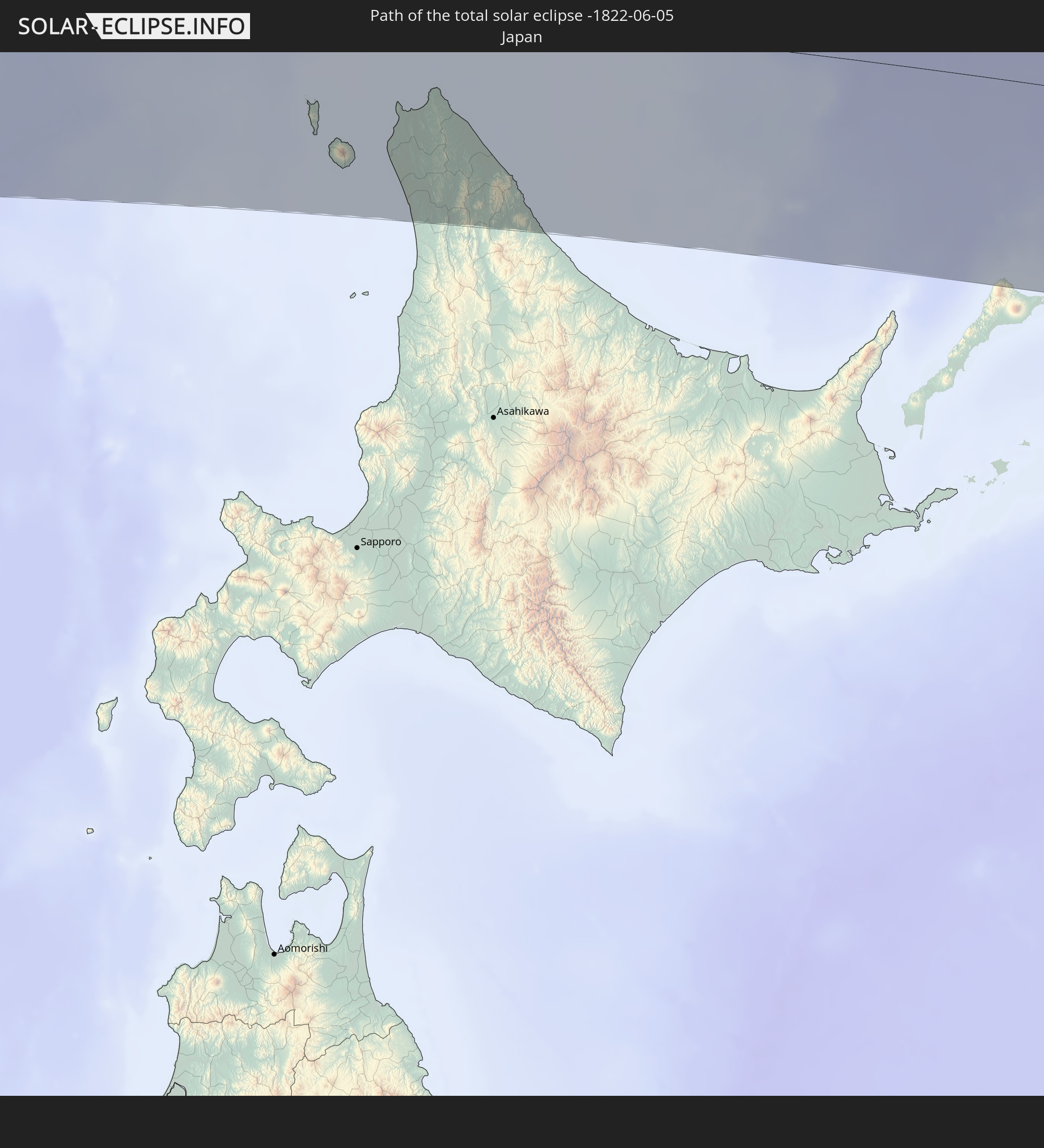
 Japan
Japan
Orte im Finsternispfad
Die nachfolgene Tabelle zeigt Städte und Orte mit mehr als 5.000 Einwohnern, die sich im Finsternispfad befinden. Städte mit mehr als 100.000 Einwohnern sind dick gekennzeichnet. Mit einem Klick auf den Ort öffnet sich eine Detailkarte die die Lage des jeweiligen Ortes zusammen mit dem Verlauf der zentralen Finsternis präsentiert.
| Ort | Typ | Dauer der Verfinsterung | Ortszeit bei maximaler Verfinsterung | Entfernung zur Zentrallinie | Ø Bewölkung |
|
Al Ghayz̧ah, Al Mahrah
|
total | - | 05:13:51 UTC+03:06 | 38 km | 37% |
|
Şalālah, Z̧ufār
|
total | - | 05:48:29 UTC+03:41 | 31 km | 70% |
|
Chuhar Jamāli, Sindh
|
total | - | 06:43:48 UTC+04:28 | 94 km | 31% |
|
Mīrpur Batoro, Sindh
|
total | - | 06:44:18 UTC+04:28 | 115 km | 26% |
|
Jāti, Sindh
|
total | - | 06:43:49 UTC+04:28 | 78 km | 21% |
|
Kario, Sindh
|
total | - | 06:44:29 UTC+04:28 | 106 km | 31% |
|
Talhār, Sindh
|
total | - | 06:44:39 UTC+04:28 | 103 km | 30% |
|
Badīn, Sindh
|
total | - | 06:44:22 UTC+04:28 | 80 km | 29% |
|
Rājo Khanāni, Sindh
|
total | - | 06:44:47 UTC+04:28 | 111 km | 25% |
|
Tando Bāgo, Sindh
|
total | - | 06:44:34 UTC+04:28 | 87 km | 23% |
|
Kadhan, Sindh
|
total | - | 06:44:11 UTC+04:28 | 56 km | 29% |
|
Samaro, Sindh
|
total | - | 06:45:20 UTC+04:28 | 114 km | 19% |
|
Naukot, Sindh
|
total | - | 06:44:47 UTC+04:28 | 73 km | 21% |
|
Kunri, Sindh
|
total | - | 06:45:15 UTC+04:28 | 96 km | 19% |
|
Diplo, Sindh
|
total | - | 06:44:21 UTC+04:28 | 25 km | 25% |
|
Nabīsar, Sindh
|
total | - | 06:45:08 UTC+04:28 | 82 km | 17% |
|
Umarkot, Sindh
|
total | - | 06:45:32 UTC+04:28 | 106 km | 19% |
|
Mithi, Sindh
|
total | - | 06:44:45 UTC+04:28 | 42 km | 17% |
|
Islāmkot, Sindh
|
total | - | 06:44:50 UTC+04:28 | 19 km | 19% |
|
Jodhpur, Rajasthan
|
total | - | 07:40:57 UTC+05:21 | 35 km | 12% |
|
Pāli, Rajasthan
|
total | - | 07:40:26 UTC+05:21 | 29 km | 14% |
|
Ajmer, Rajasthan
|
total | - | 07:41:59 UTC+05:21 | 28 km | 15% |
|
Sīkar, Rajasthan
|
total | - | 07:43:51 UTC+05:21 | 59 km | 17% |
|
Jaipur, Rajasthan
|
total | - | 07:43:13 UTC+05:21 | 40 km | 19% |
|
Rohtak, Haryana
|
total | - | 07:46:29 UTC+05:21 | 111 km | 28% |
|
Alwar, Rajasthan
|
total | - | 07:44:36 UTC+05:21 | 19 km | 40% |
|
Sonīpat, Haryana
|
total | - | 07:46:53 UTC+05:21 | 99 km | 53% |
|
Gurgaon, Haryana
|
total | - | 07:46:07 UTC+05:21 | 47 km | 44% |
|
Nāngloi Jāt, NCT
|
total | - | 07:46:27 UTC+05:21 | 66 km | 35% |
|
Delhi, NCT
|
total | - | 07:46:31 UTC+05:21 | 55 km | 33% |
|
Farīdābād, Haryana
|
total | - | 07:46:13 UTC+05:21 | 28 km | 40% |
|
Ghāziābād, Uttar Pradesh
|
total | - | 07:46:40 UTC+05:21 | 46 km | 38% |
|
Bharatpur, Rajasthan
|
total | - | 07:44:38 UTC+05:21 | 95 km | 68% |
|
Greater Noida, Uttar Pradesh
|
total | - | 07:46:29 UTC+05:21 | 25 km | 52% |
|
Mathura, Uttar Pradesh
|
total | - | 07:45:09 UTC+05:21 | 77 km | 63% |
|
Muzaffarnagar, Uttar Pradesh
|
total | - | 07:48:00 UTC+05:21 | 110 km | 30% |
|
Meerut, Uttar Pradesh
|
total | - | 07:47:17 UTC+05:21 | 63 km | 32% |
|
Hāpur, Uttar Pradesh
|
total | - | 07:46:58 UTC+05:21 | 36 km | 33% |
|
Bulandshahr, Uttar Pradesh
|
total | - | 07:46:33 UTC+05:21 | 1 km | 32% |
|
Alīgarh, Uttar Pradesh
|
total | - | 07:45:56 UTC+05:21 | 60 km | 54% |
|
Sambhal, Uttar Pradesh
|
total | - | 07:47:16 UTC+05:21 | 17 km | 40% |
|
Morādābād, Uttar Pradesh
|
total | - | 07:47:47 UTC+05:21 | 3 km | 39% |
|
Rāmpur, Uttar Pradesh
|
total | - | 07:47:54 UTC+05:21 | 19 km | 40% |
|
Bareilly, Uttar Pradesh
|
total | - | 07:47:30 UTC+05:21 | 83 km | 41% |
|
Mahendranagar, Far Western
|
total | - | 08:09:05 UTC+05:41 | 73 km | 47% |
|
Dārchulā, Western Region
|
total | - | 07:50:30 UTC+05:21 | 5 km | 40% |
|
Dadeldhurā, Far Western
|
total | - | 08:09:50 UTC+05:41 | 49 km | 51% |
|
Dhangarhi, Far Western
|
total | - | 08:08:59 UTC+05:41 | 106 km | 48% |
|
Dipayal, Far Western
|
total | - | 08:10:03 UTC+05:41 | 71 km | 43% |
|
Zhangye, Gansu
|
total | - | 11:06:25 UTC+08:00 | 36 km | 45% |
|
Xilin Hot, Inner Mongolia
|
total | - | 11:39:07 UTC+08:00 | 10 km | 50% |
|
Ulanhot, Inner Mongolia
|
total | - | 11:51:18 UTC+08:00 | 104 km | 53% |
|
Guangming, Jilin
|
total | - | 11:52:18 UTC+08:00 | 12 km | 55% |
|
Baicheng, Jilin
|
total | - | 11:52:28 UTC+08:00 | 41 km | 57% |
|
Dalai, Jilin
|
total | - | 11:55:07 UTC+08:00 | 9 km | 56% |
|
Fuyu, Jilin
|
total | - | 11:55:59 UTC+08:00 | 32 km | 58% |
|
Honggang, Heilongjiang
|
total | - | 11:56:22 UTC+08:00 | 101 km | 63% |
|
Daqing, Heilongjiang
|
total | - | 11:56:37 UTC+08:00 | 120 km | 63% |
|
Anda, Heilongjiang
|
total | - | 11:57:08 UTC+08:00 | 96 km | 60% |
|
Dehui, Jilin
|
total | - | 11:57:30 UTC+08:00 | 114 km | 63% |
|
Zhaodong, Heilongjiang
|
total | - | 11:58:16 UTC+08:00 | 52 km | 61% |
|
Shuangcheng, Heilongjiang
|
total | - | 11:58:43 UTC+08:00 | 31 km | 60% |
|
Yushu, Jilin
|
total | - | 11:59:06 UTC+08:00 | 94 km | 63% |
|
Hulan, Heilongjiang
|
total | - | 11:59:22 UTC+08:00 | 36 km | 61% |
|
Harbin, Heilongjiang
|
total | - | 11:59:26 UTC+08:00 | 10 km | 59% |
|
Acheng, Heilongjiang
|
total | - | 12:00:00 UTC+08:00 | 16 km | 63% |
|
Suihua, Heilongjiang
|
total | - | 12:00:08 UTC+08:00 | 104 km | 64% |
|
Wuchang, Heilongjiang
|
total | - | 12:00:15 UTC+08:00 | 88 km | 59% |
|
Jiamusi, Heilongjiang
|
total | - | 12:05:54 UTC+08:00 | 96 km | 66% |
|
Boli, Heilongjiang
|
total | - | 12:06:27 UTC+08:00 | 21 km | 70% |
|
Taihe, Heilongjiang
|
total | - | 12:06:56 UTC+08:00 | 22 km | 70% |
|
Jixi, Heilongjiang
|
total | - | 12:07:11 UTC+08:00 | 74 km | 67% |
|
Shuangyashan, Heilongjiang
|
total | - | 12:07:21 UTC+08:00 | 74 km | 70% |
|
Baoshan, Heilongjiang
|
total | - | 12:07:50 UTC+08:00 | 64 km | 71% |
|
Lesozavodsk, Primorskiy
|
total | - | 12:59:02 UTC+08:47 | 64 km | 68% |
|
Kirovskiy, Primorskiy
|
total | - | 12:59:16 UTC+08:47 | 107 km | 64% |
|
Gornyye Klyuchi, Primorskiy
|
total | - | 12:59:14 UTC+08:47 | 90 km | 67% |
|
Dal’nerechensk, Primorskiy
|
total | - | 12:59:27 UTC+08:47 | 14 km | 64% |
|
Luchegorsk, Primorskiy
|
total | - | 13:00:04 UTC+08:47 | 46 km | 69% |
|
Bikin, Khabarovsk Krai
|
total | - | 13:00:03 UTC+08:47 | 83 km | 64% |
|
Wakkanai, Hokkaido
|
total | - | 13:25:11 UTC+09:00 | 55 km | 67% |
|
Makubetsu, Hokkaido
|
total | - | 13:25:26 UTC+09:00 | 59 km | 67% |
|
Gornozavodsk, Sakhalin
|
total | - | 14:39:32 UTC+10:14 | 73 km | 78% |
|
Nevel’sk, Sakhalin
|
total | - | 14:39:29 UTC+10:14 | 87 km | 72% |
|
Aniva, Sakhalin
|
total | - | 14:40:27 UTC+10:14 | 95 km | 73% |
|
Korsakov, Sakhalin
|
total | - | 14:40:52 UTC+10:14 | 88 km | 74% |