Totale Sonnenfinsternis vom 23.05.-1886
| Wochentag: | Montag |
| Maximale Dauer der Verfinsterung: | 04m59s |
| Maximale Breite des Finsternispfades: | 226 km |
| Saroszyklus: | 17 |
| Bedeckungsgrad: | 100% |
| Magnitude: | 1.0644 |
| Gamma: | 0.3658 |
Wo kann man die Sonnenfinsternis vom 23.05.-1886 sehen?
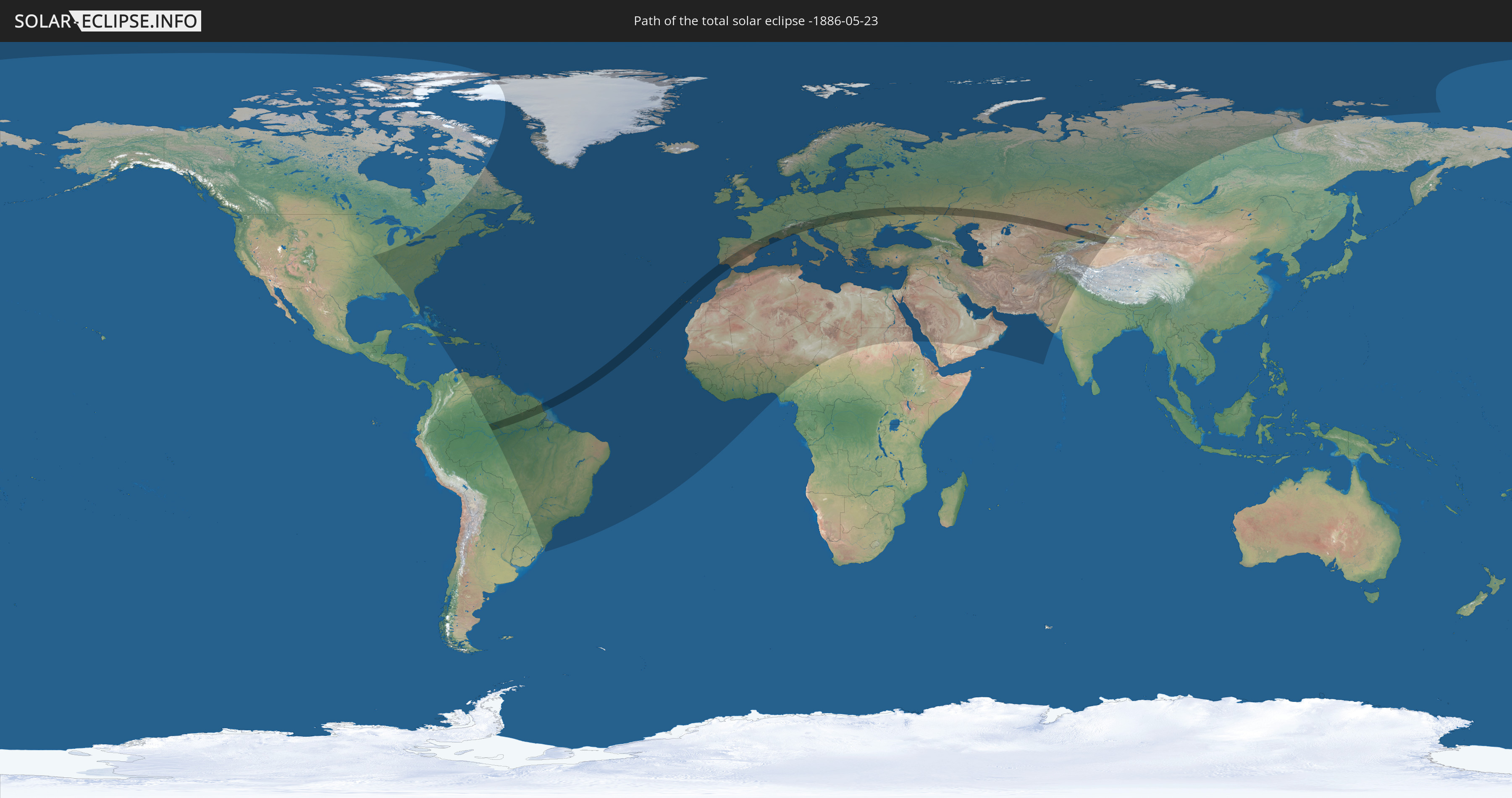
Die Sonnenfinsternis am 23.05.-1886 kann man in 140 Ländern als partielle Sonnenfinsternis beobachten.
Der Finsternispfad verläuft durch 23 Länder. Nur in diesen Ländern ist sie als totale Sonnenfinsternis zu sehen.
In den folgenden Ländern ist die Sonnenfinsternis total zu sehen
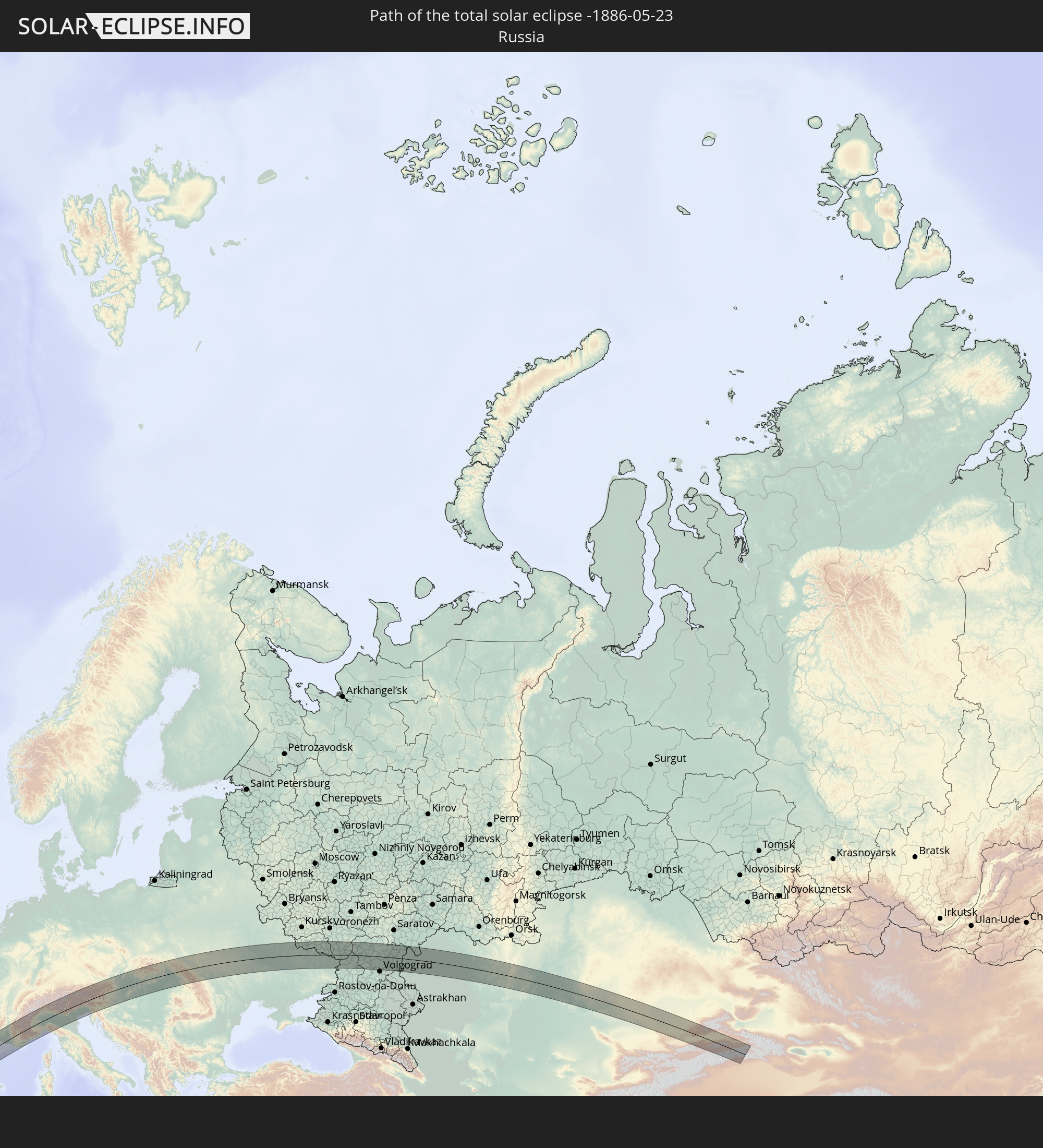 Russland
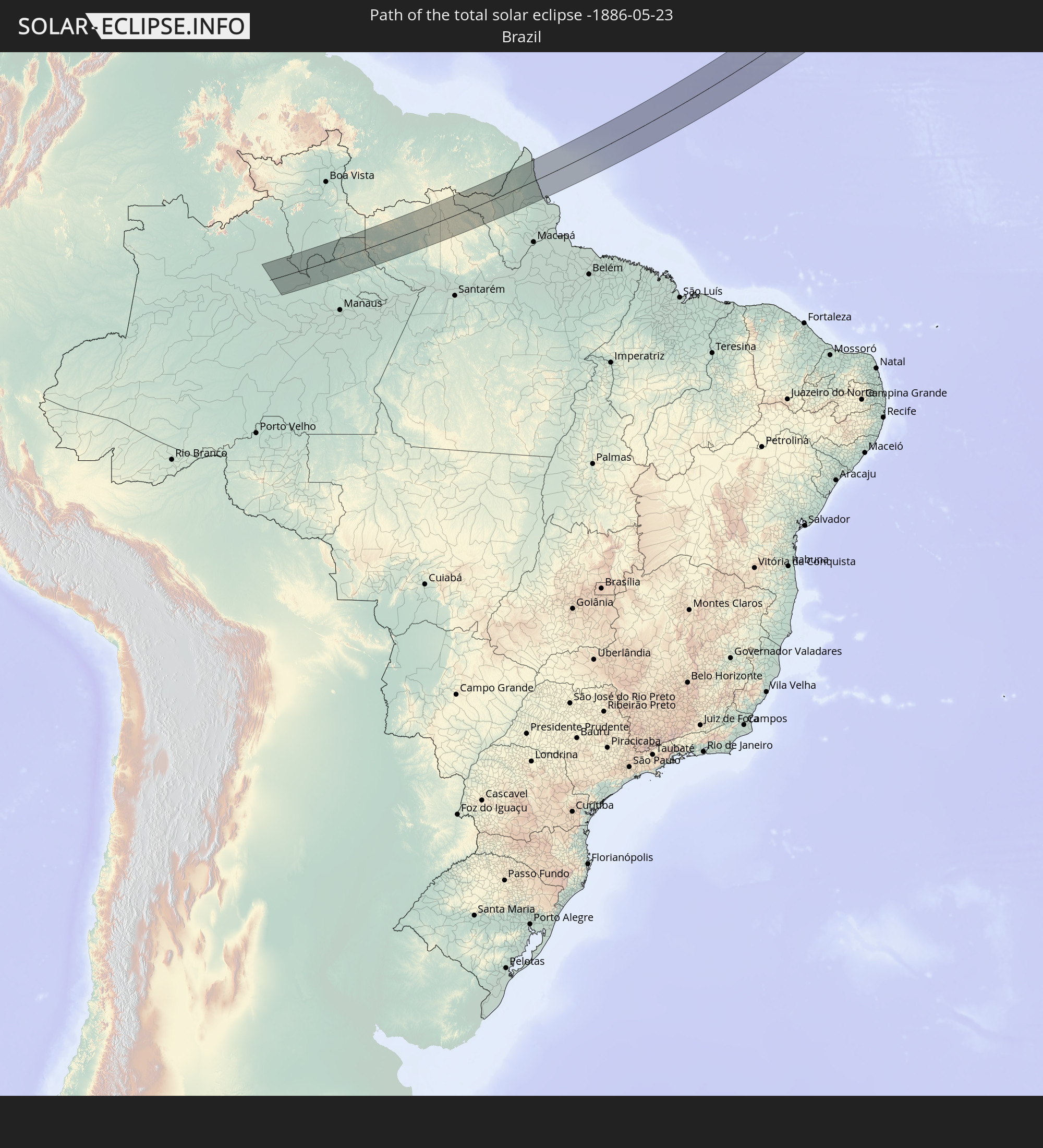 Brasilien
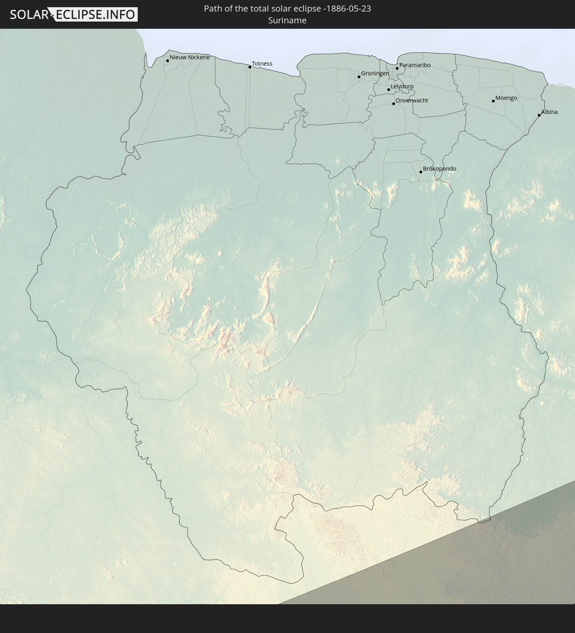 Suriname
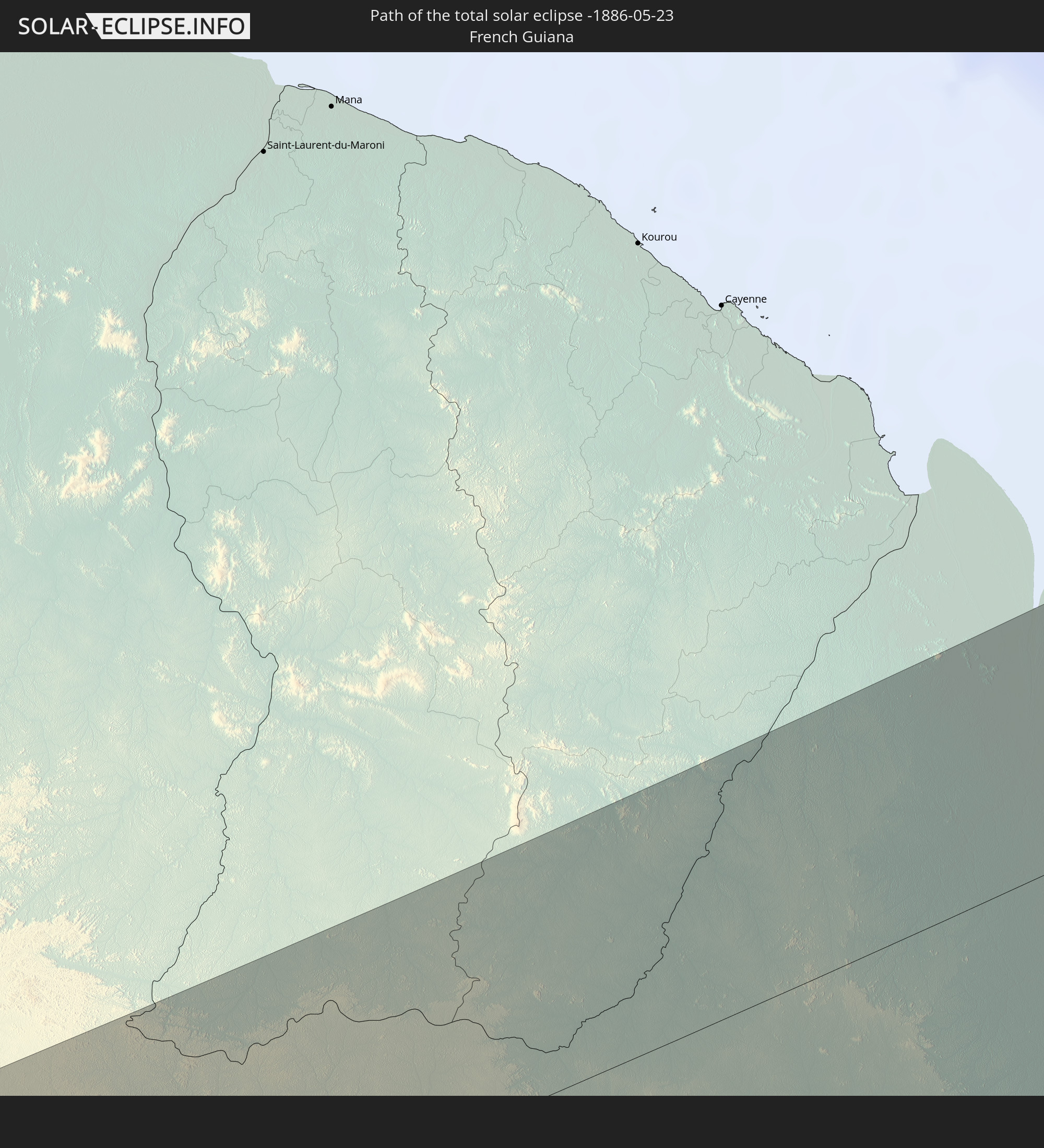 Französisch-Guayana
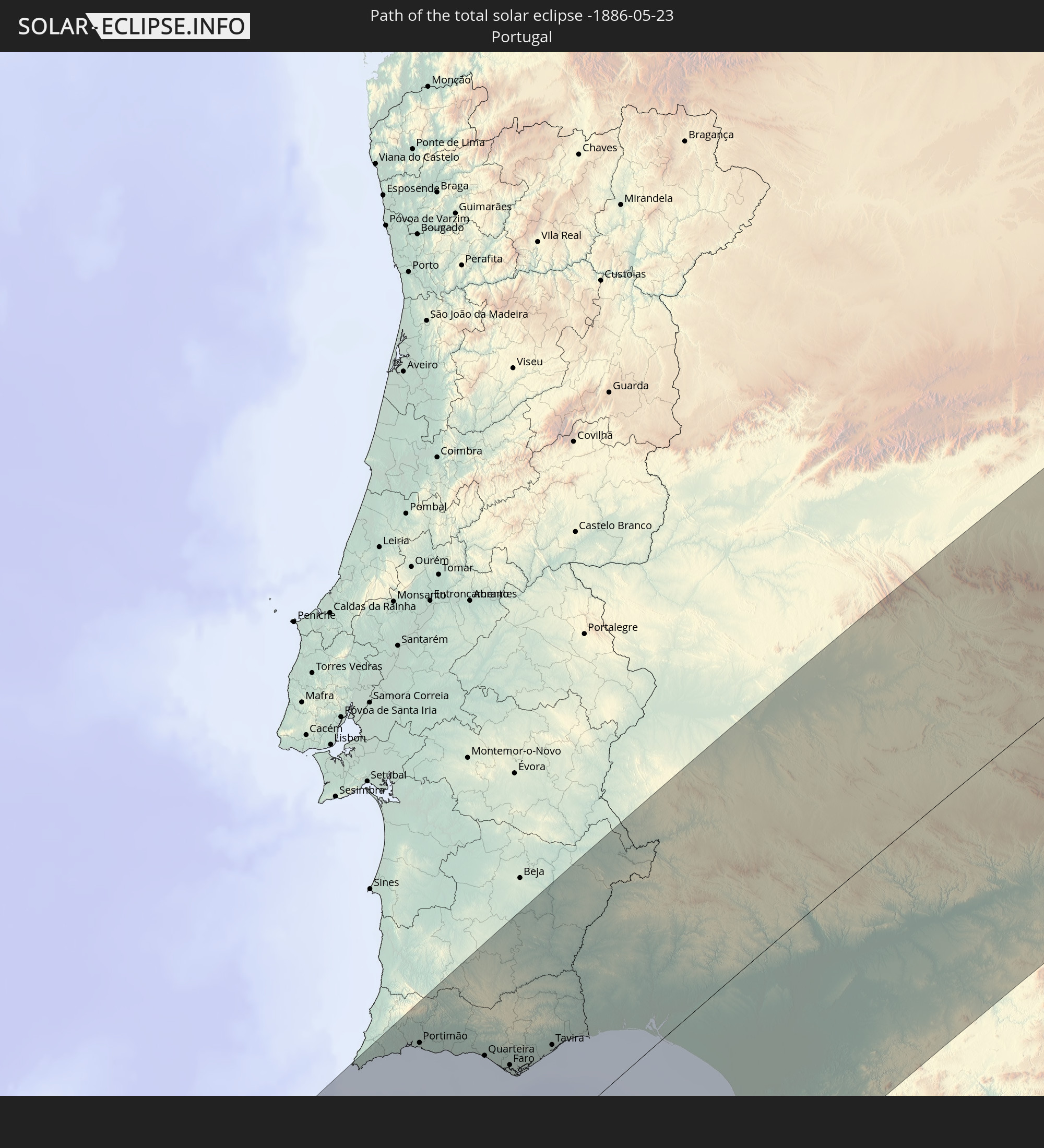 Portugal
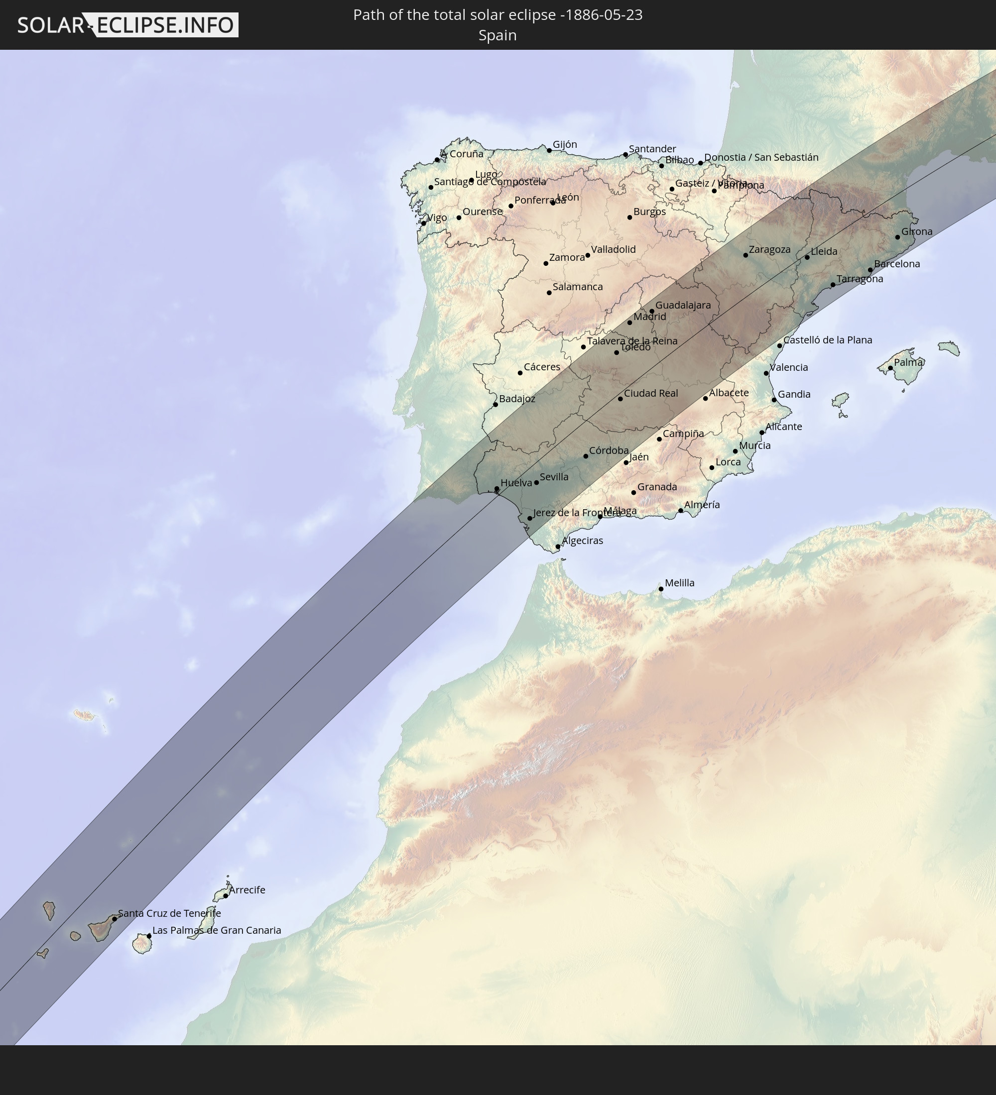 Spanien
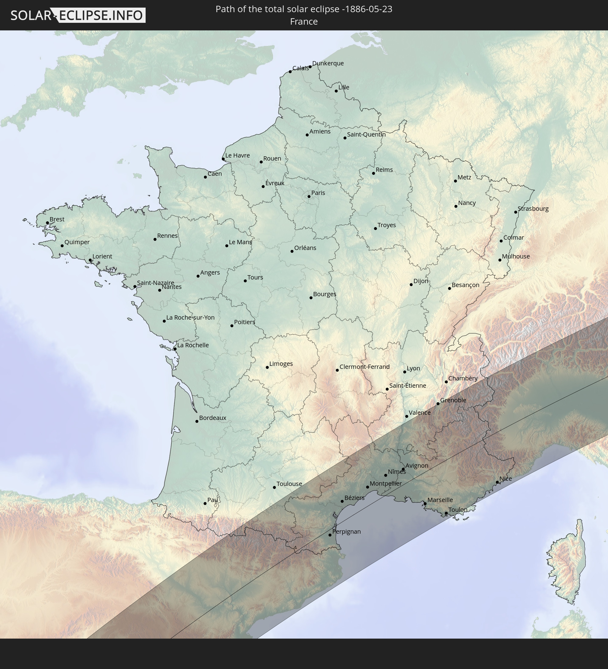 Frankreich
 Andorra
 Deutschland
 Schweiz
 Italien
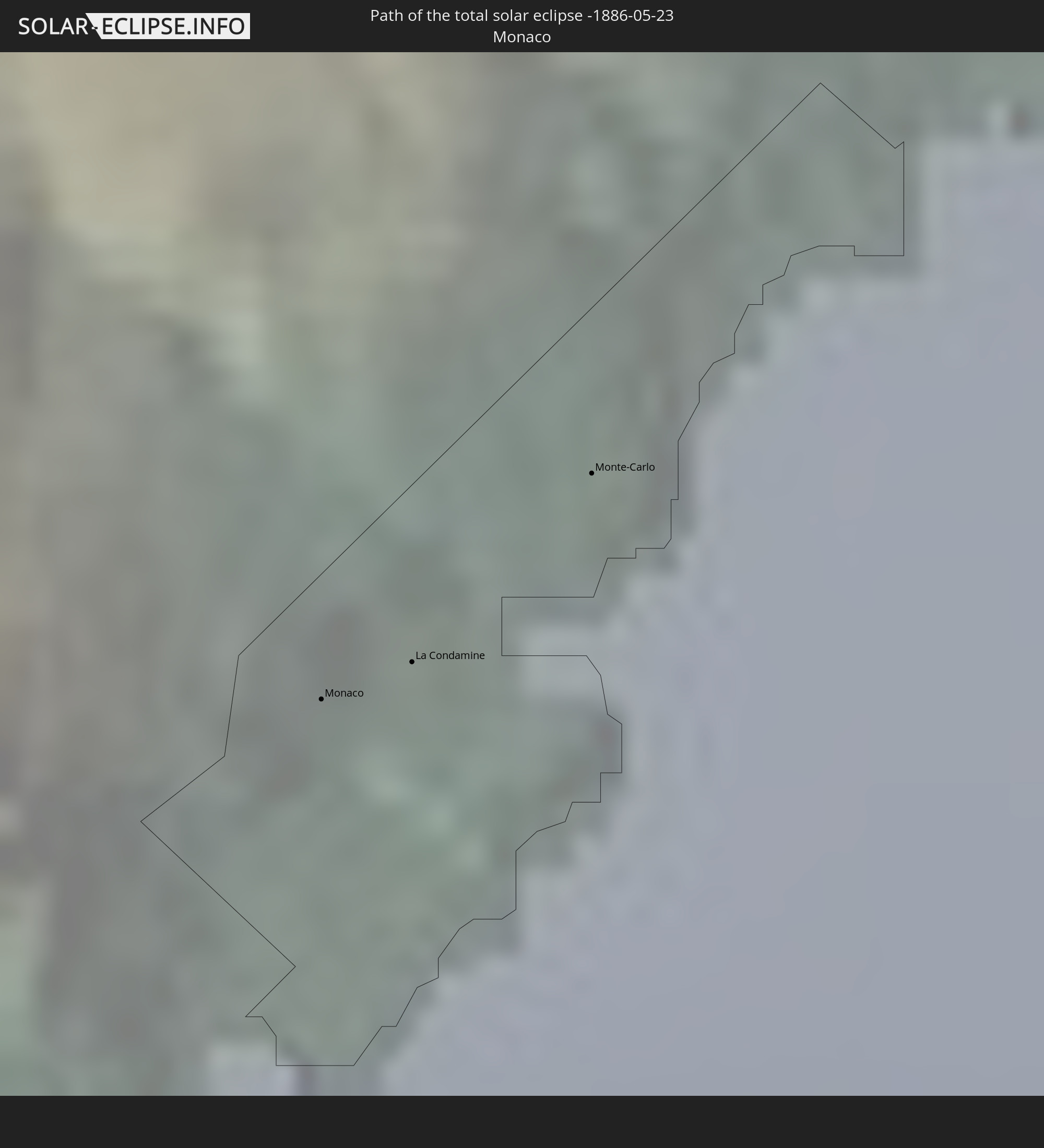 Monaco
 Österreich
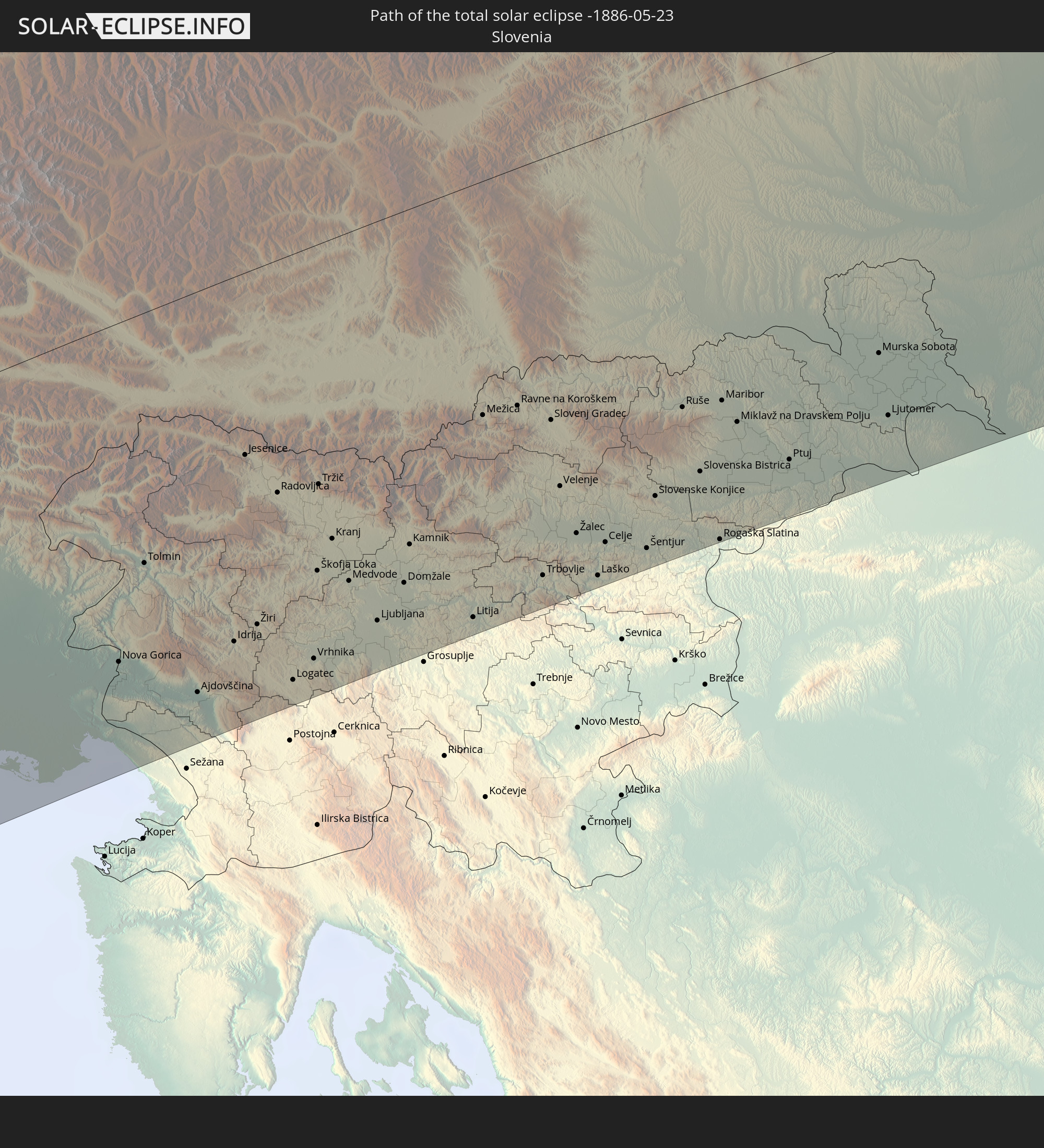 Slowenien
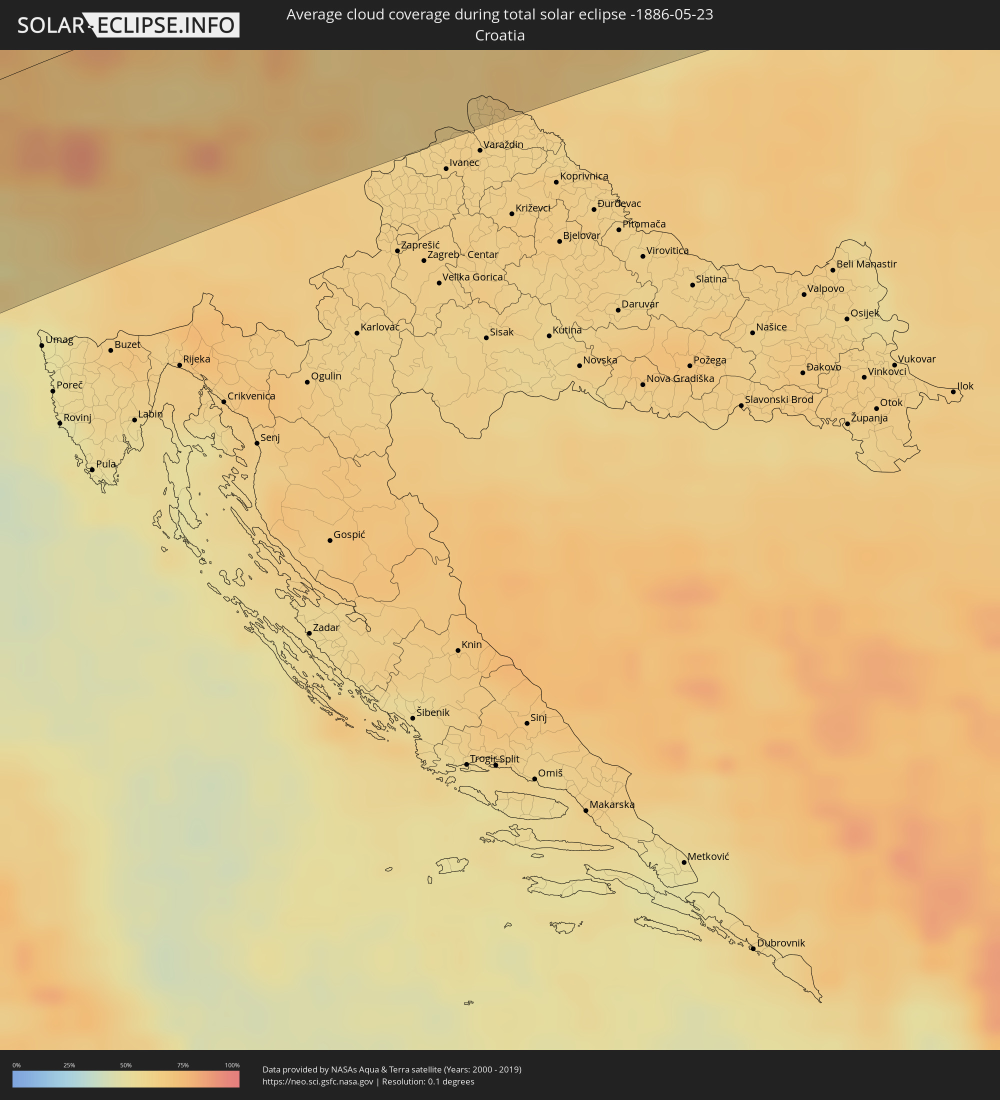
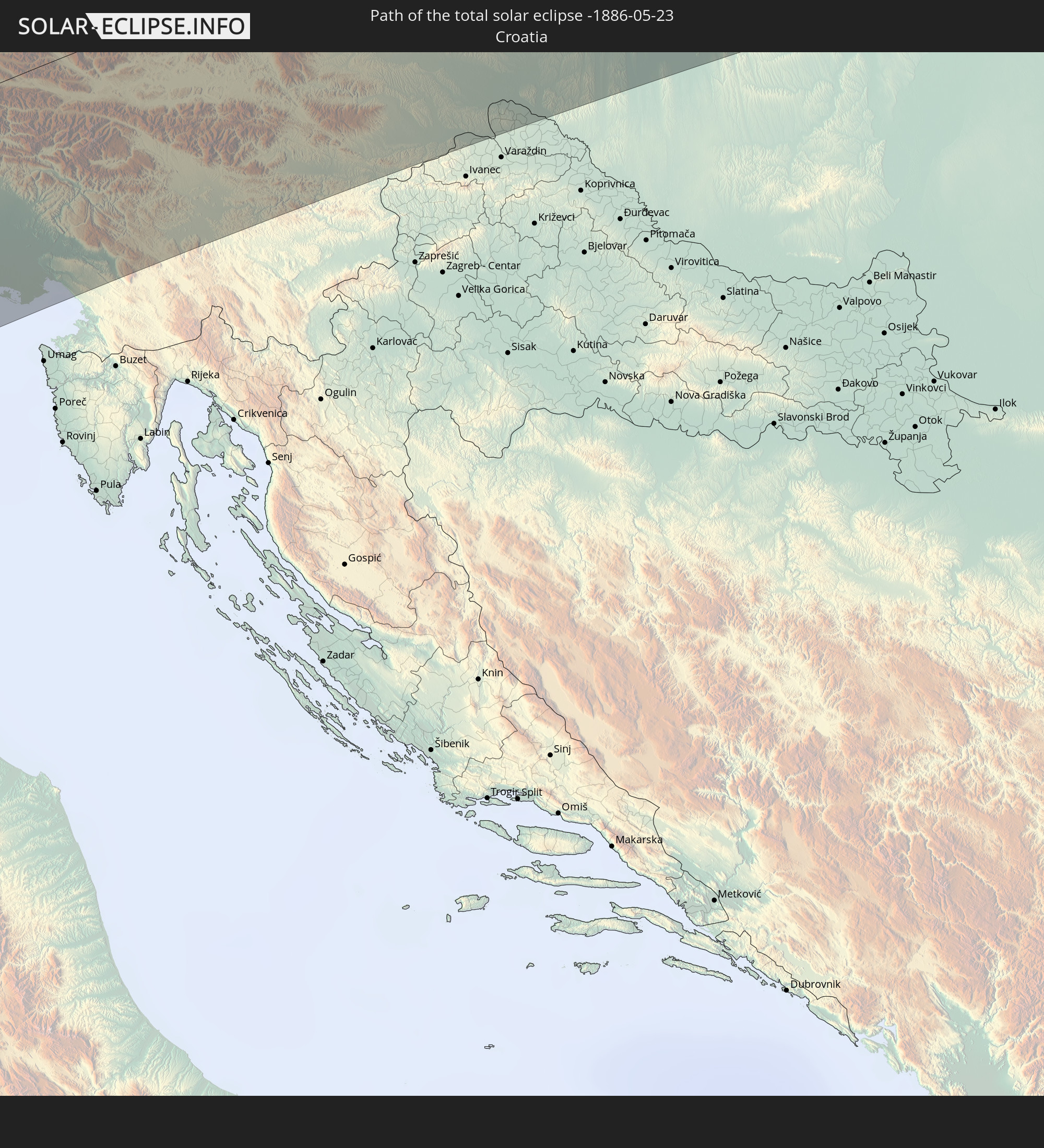 Kroatien
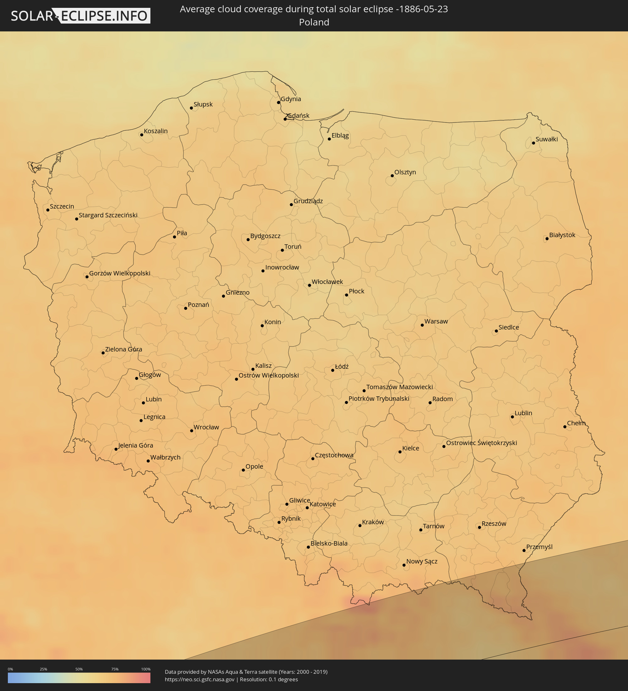
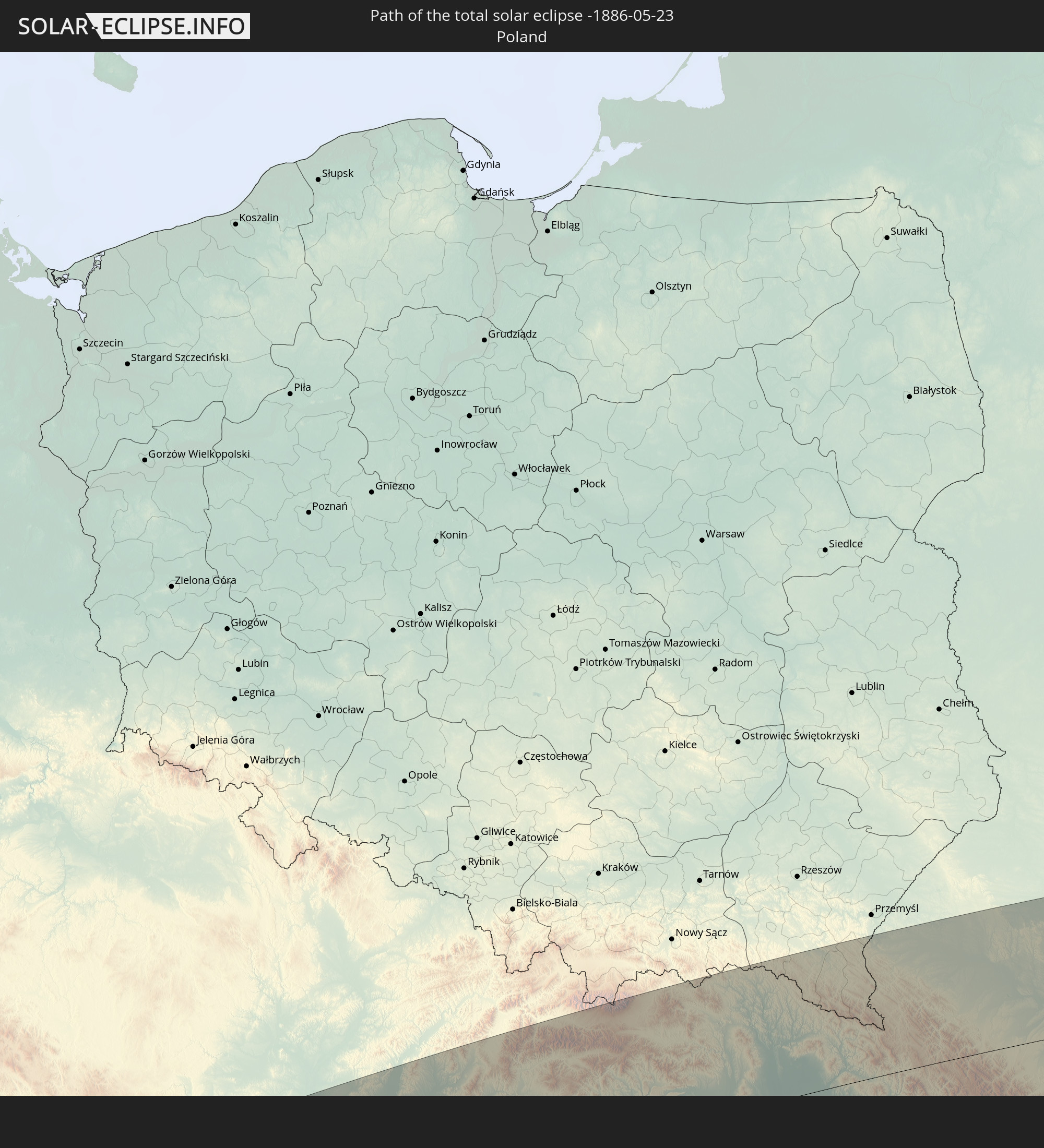 Polen
Polen
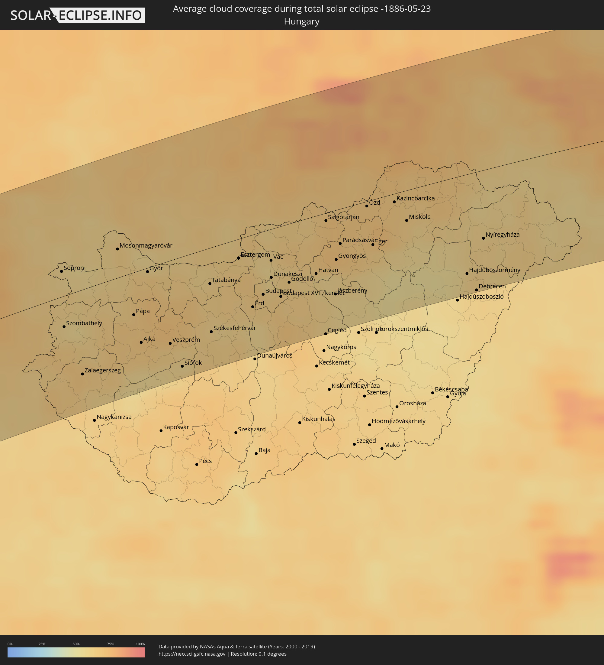
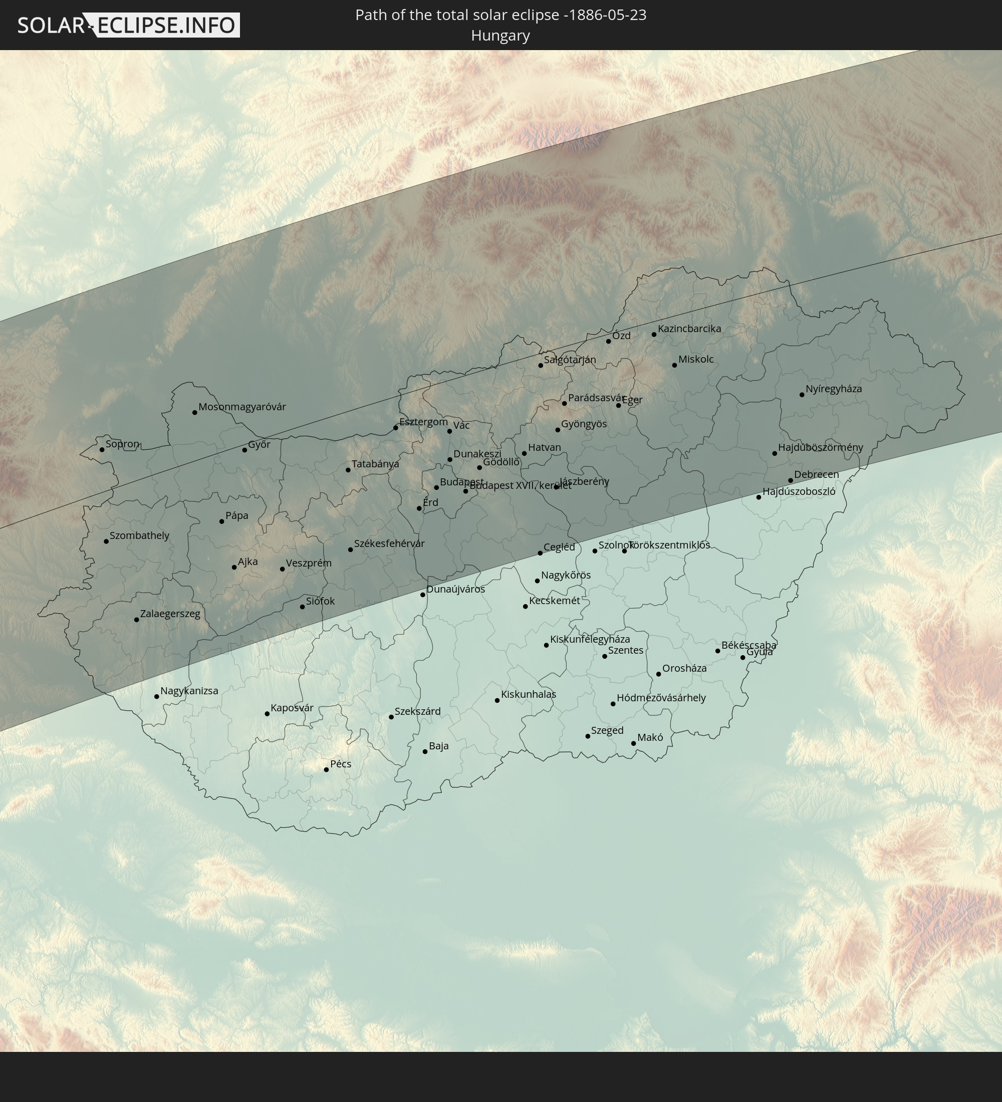 Ungarn
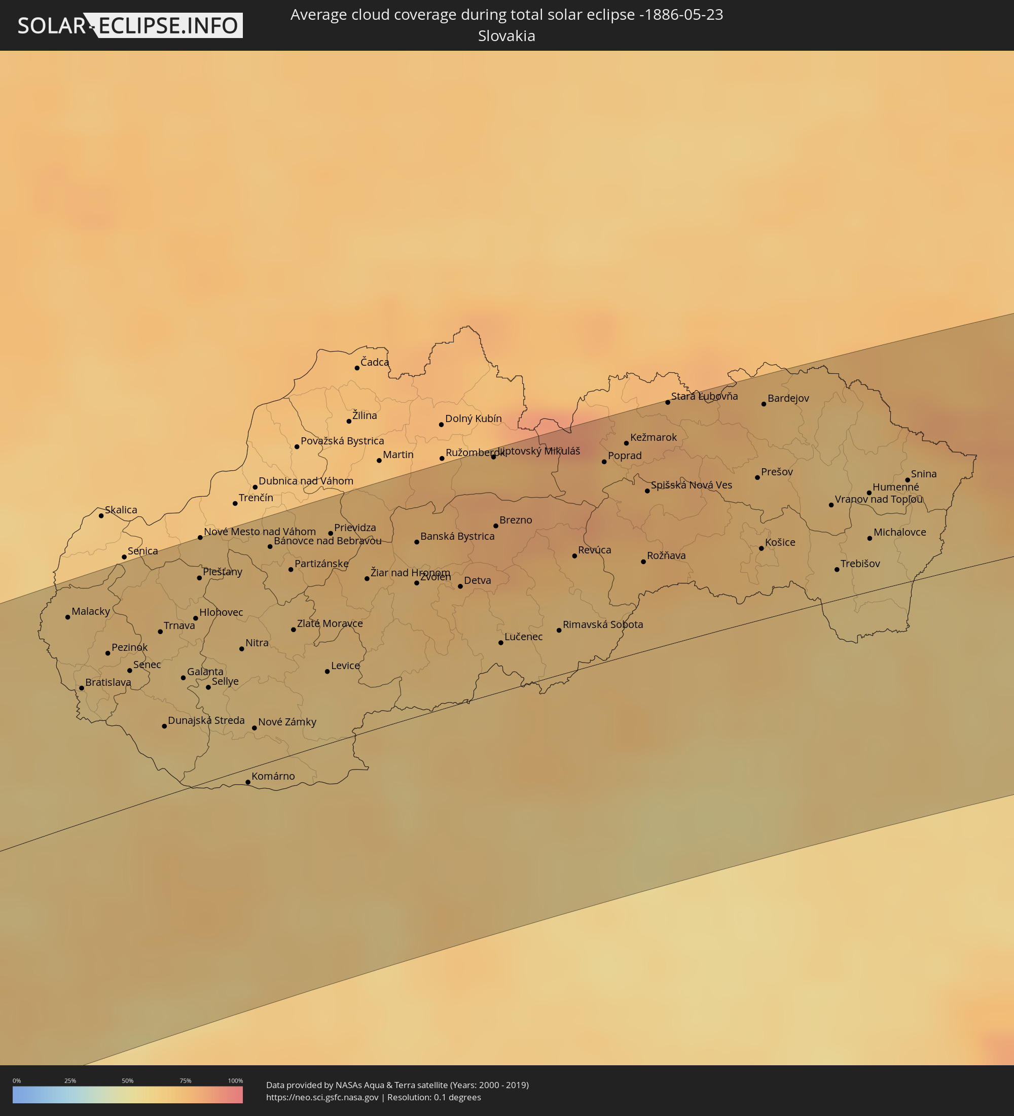
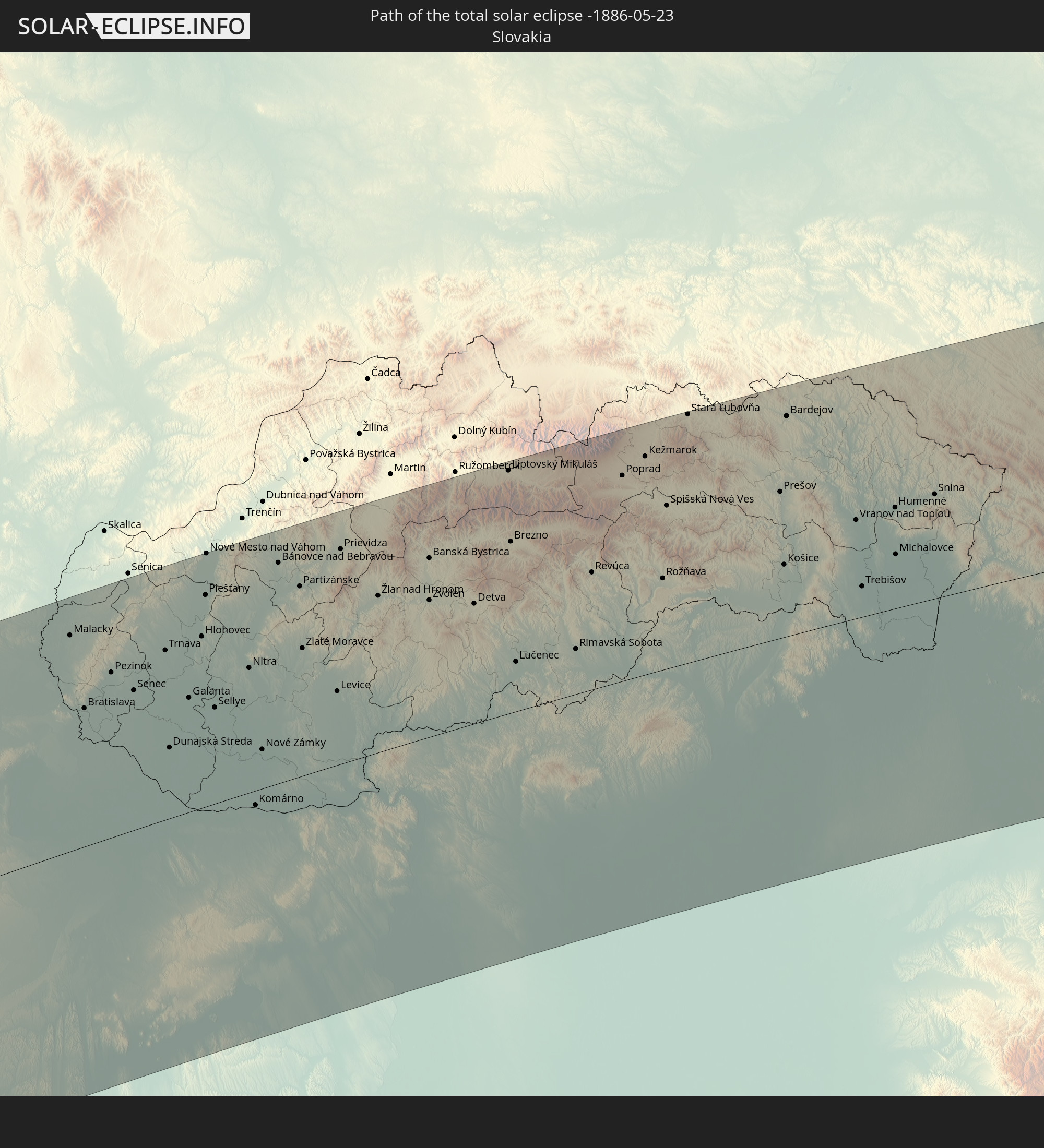 Slowakei
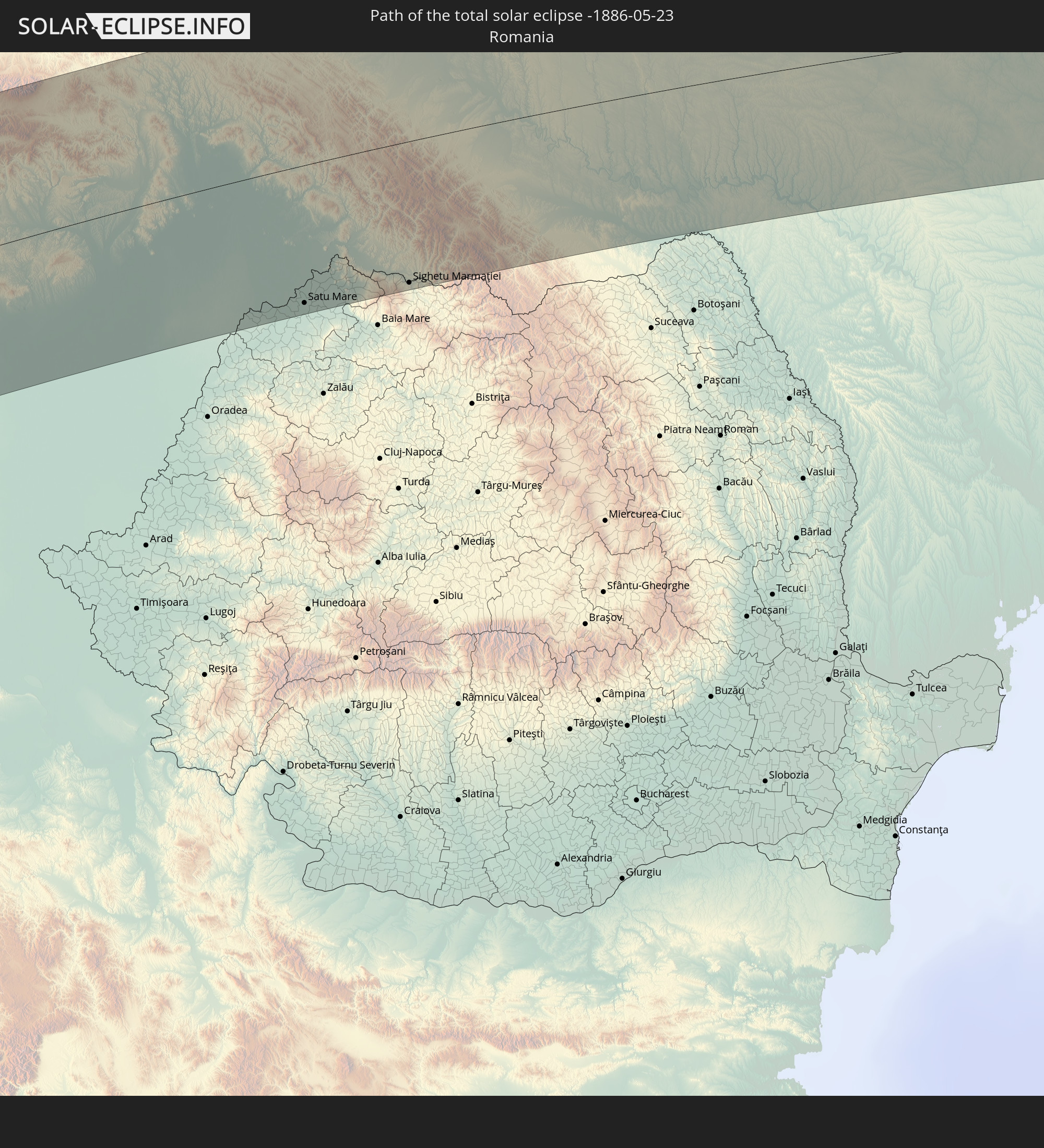 Rumänien
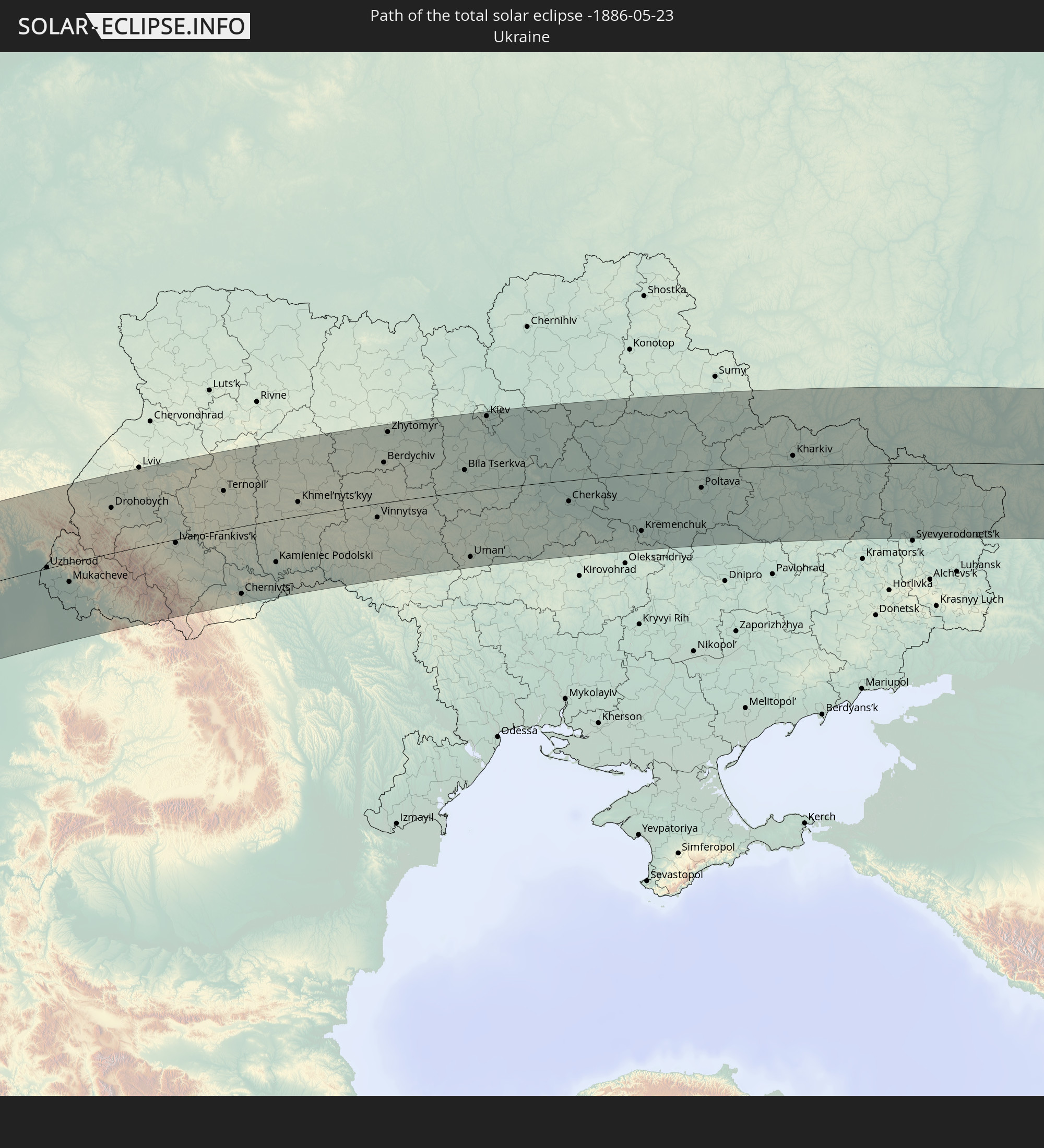 Ukraine
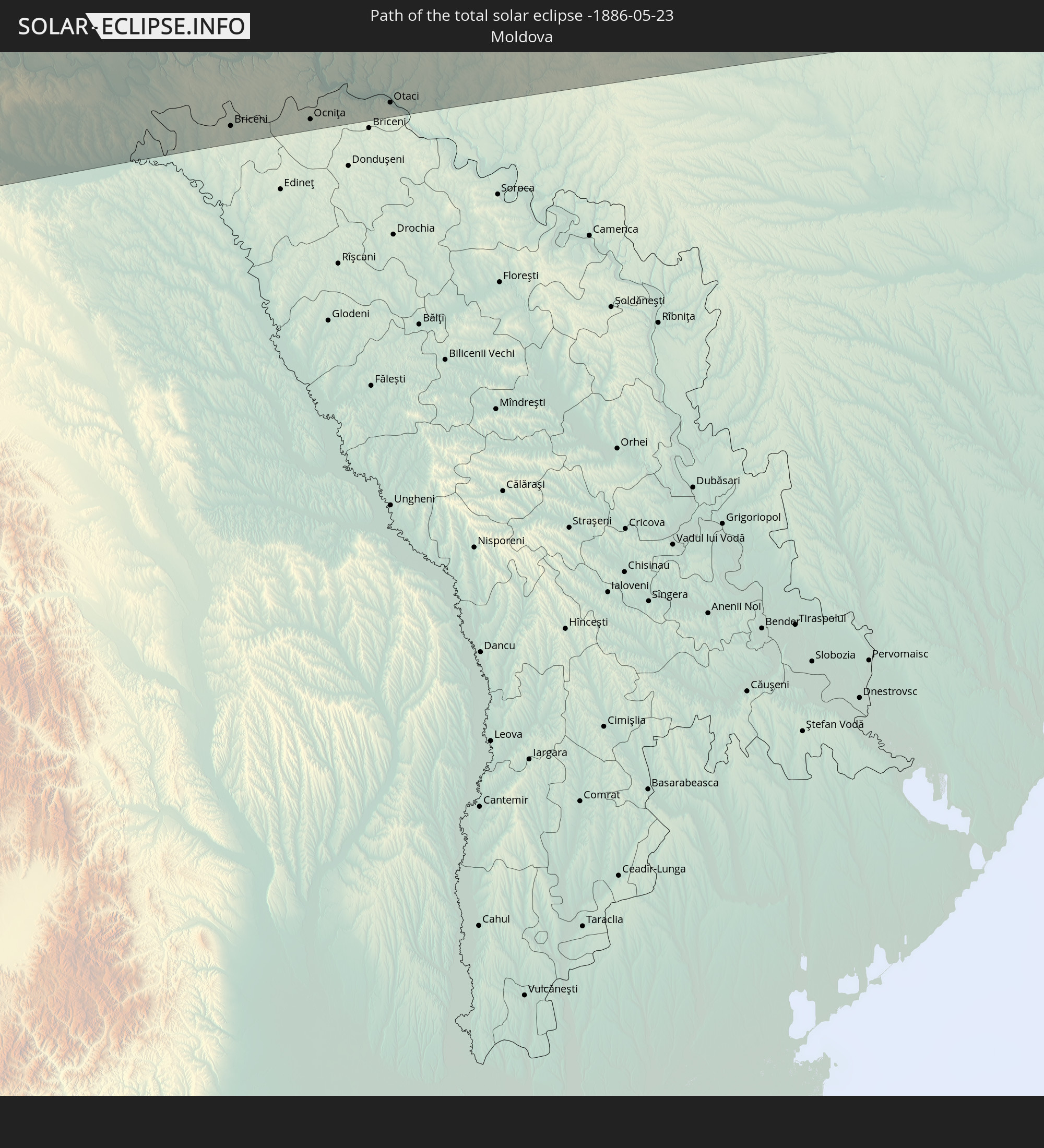 Moldawien
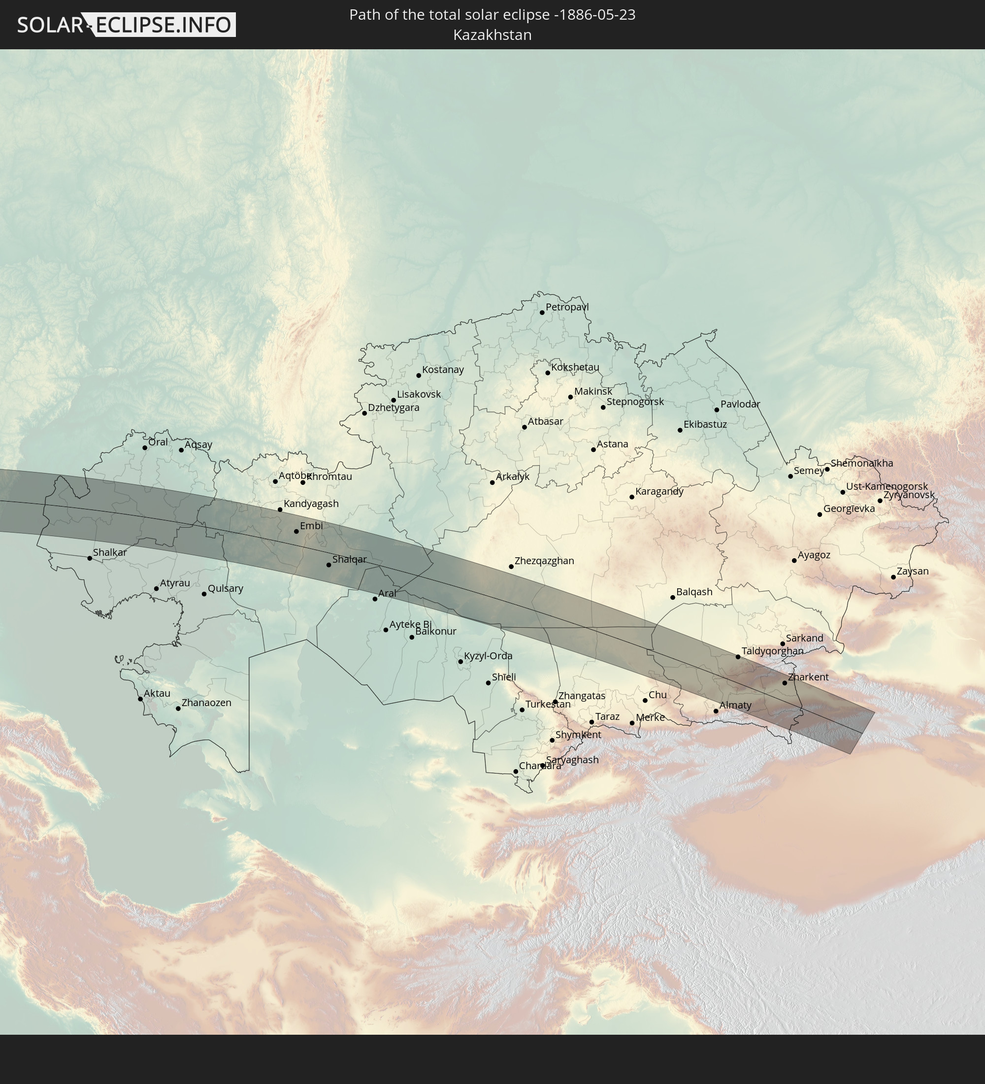 Kasachstan
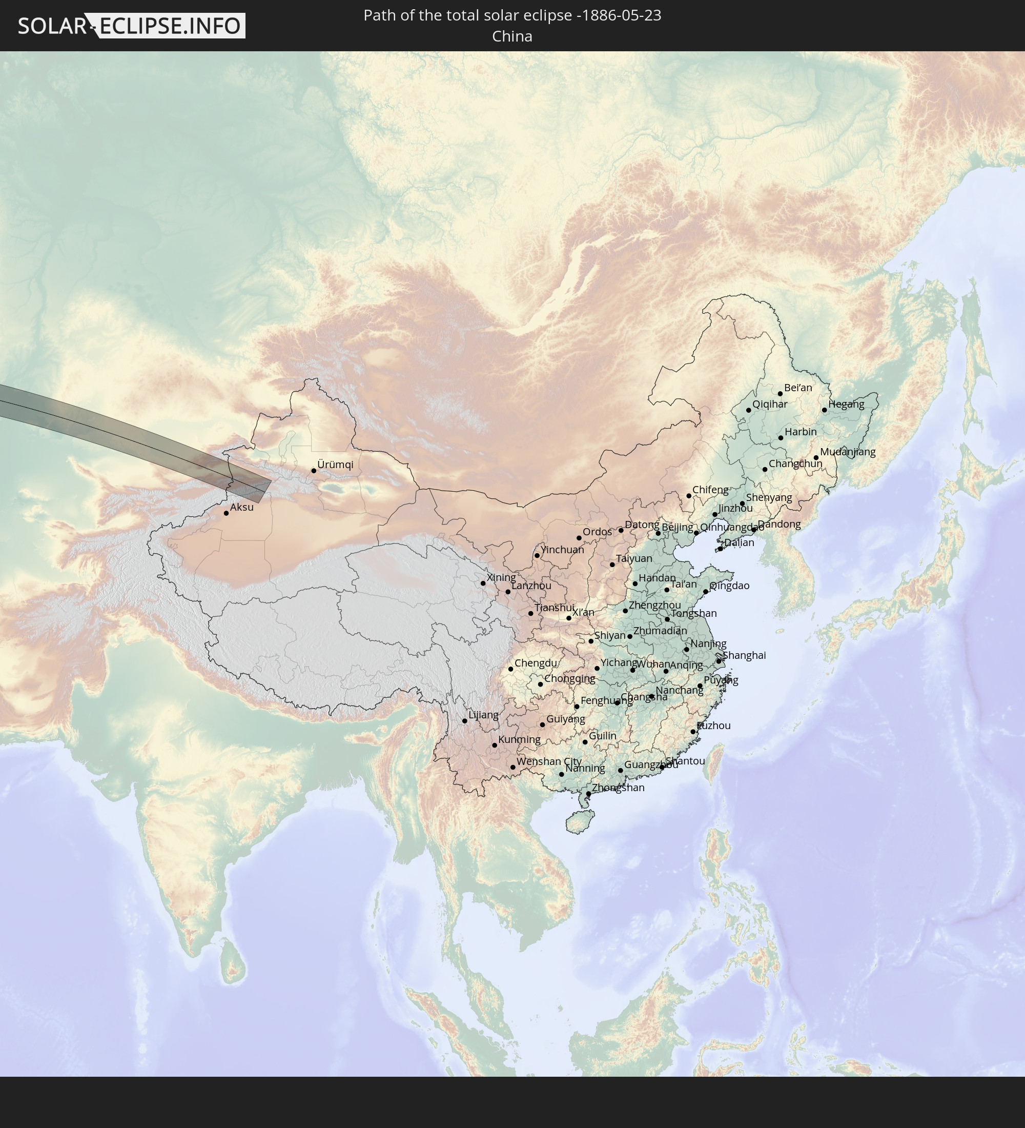 Volksrepublik China
In den folgenden Ländern ist die Sonnenfinsternis partiell zu sehen
 Russland
 Vereinigte Staaten
 United States Minor Outlying Islands
 Kanada
 Grönland
 Kuba
Kuba
 Kolumbien
 Bahamas
 Haiti
Haiti
 Brasilien
 Venezuela
 Turks- und Caicosinseln
 Dominikanische Republik
 Aruba
Aruba
 Puerto Rico
 Amerikanische Jungferninseln
 Bermuda
 Britische Jungferninseln
 Anguilla
 Saint-Martin
 Saint-Barthélemy
 St. Kitts und Nevis
 Antigua und Barbuda
 Montserrat
 Trinidad und Tobago
 Guadeloupe
 Grenada
 Dominica
 St. Vincent und die Grenadinen
 Guyana
 Martinique
 St. Lucia
 Barbados
 Suriname
 Saint-Pierre und Miquelon
 Französisch-Guayana
 Portugal
 Kap Verde
 Island
 Spanien
 Senegal
 Mauretanien
 Gambia
 Guinea-Bissau
 Guinea
 St. Helena
 Sierra Leone
 Marokko
 Mali
Mali
 Liberia
 Irland
 Spitzbergen
 Algerien
 Vereinigtes Königreich
 Elfenbeinküste
 Färöer
 Burkina Faso
 Gibraltar
 Frankreich
 Isle of Man
 Ghana
Ghana
 Guernsey
 Jersey
 Togo
Togo
 Niger
Niger
 Benin
Benin
 Andorra
 Belgien
 Nigeria
 Niederlande
 Norwegen
 Luxemburg
 Deutschland
 Schweiz
 Italien
 Monaco
 Tunesien
 Dänemark
 Kamerun
 Libyen
 Liechtenstein
 Österreich
 Schweden
 Tschechien
 San Marino
 Vatikanstadt
 Slowenien
 Tschad
 Kroatien
 Polen
Polen
 Malta
Malta
 Bosnien und Herzegowina
 Ungarn
 Slowakei
 Montenegro
 Serbien
 Albanien
 Åland Islands
 Griechenland
 Rumänien
 Mazedonien
 Finnland
 Litauen
 Lettland
 Estland
 Sudan
Sudan
 Ukraine
 Bulgarien
 Weißrussland
 Ägypten
 Türkei
 Moldawien
 Republik Zypern
 Staat Palästina
 Israel
 Saudi-Arabien
 Jordanien
 Libanon
 Syrien
 Irak
Irak
 Georgien
 Jemen
Jemen
 Armenien
 Iran
Iran
 Aserbaidschan
 Kasachstan
 Kuwait
 Bahrain
 Katar
Katar
 Vereinigte Arabische Emirate
 Oman
Oman
 Turkmenistan
 Usbekistan
 Afghanistan
 Pakistan
 Tadschikistan
 Indien
 Kirgisistan
 Volksrepublik China
 Mongolei
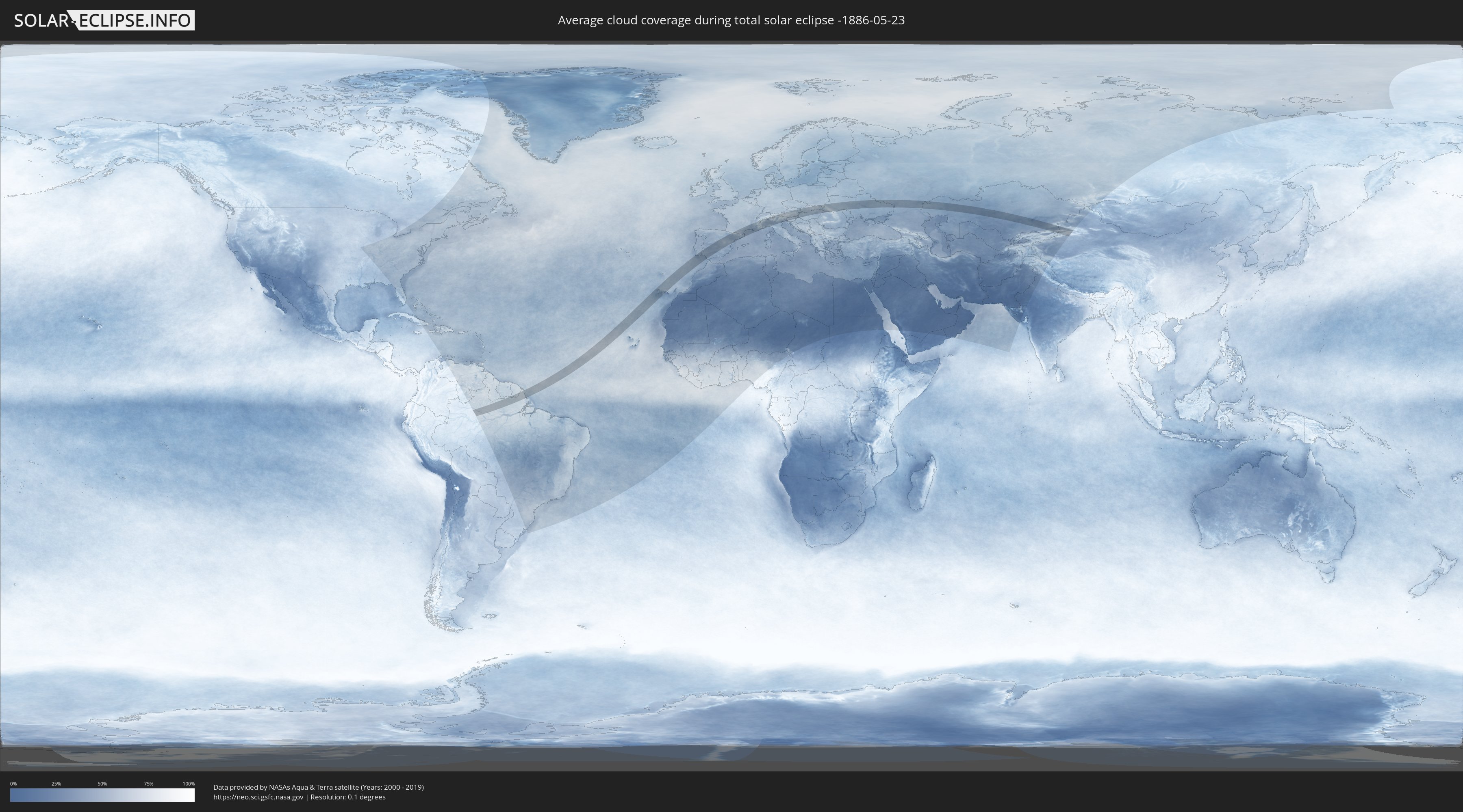
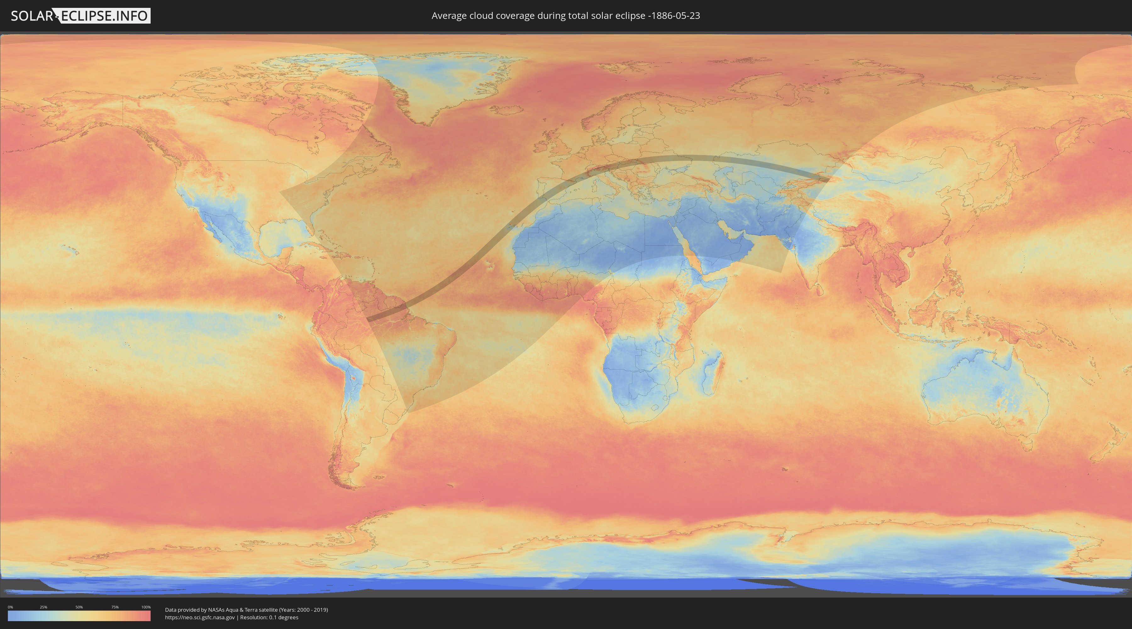
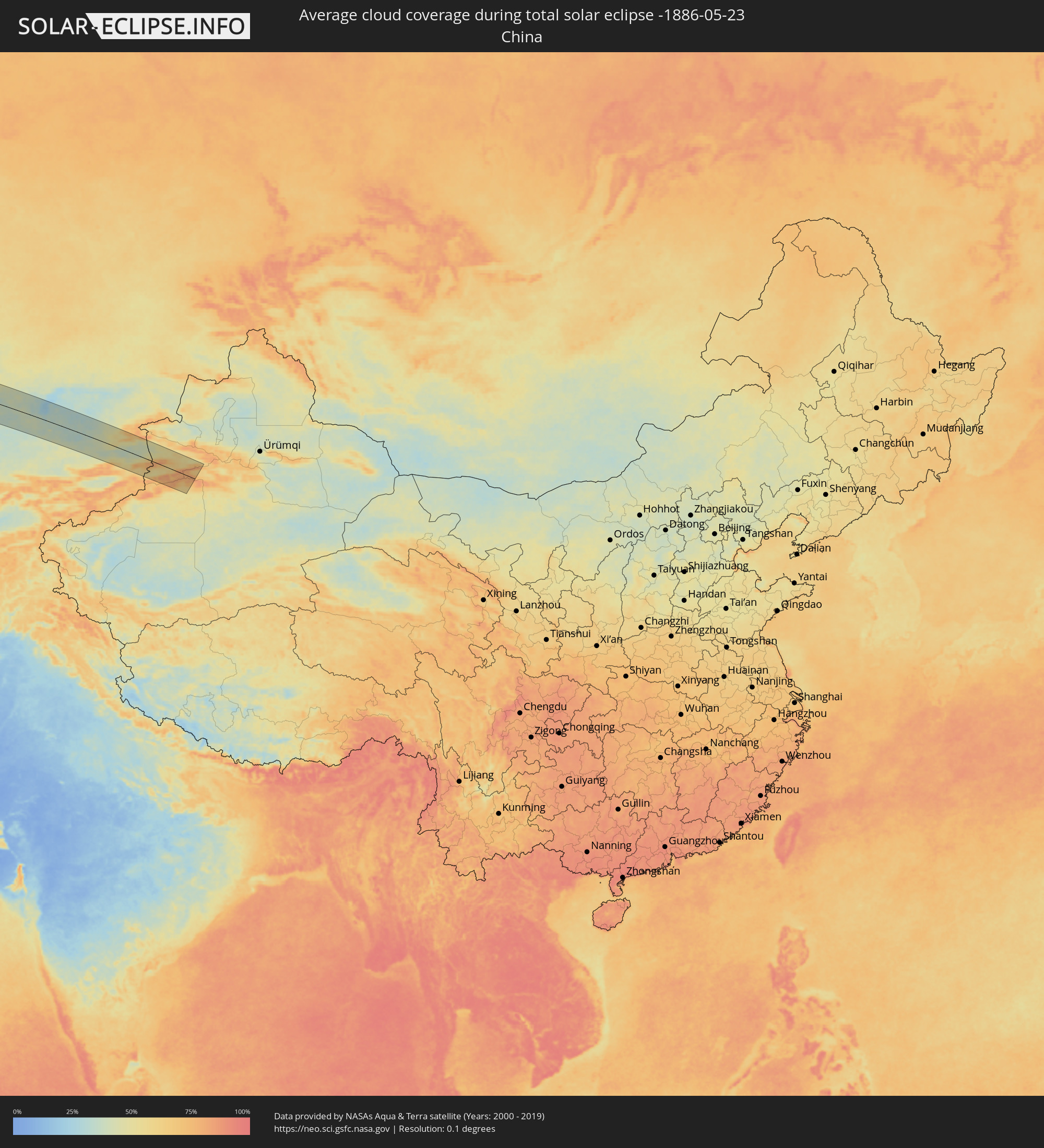
Wie wird das Wetter während der totalen Sonnenfinsternis am 23.05.-1886?
Wo ist der beste Ort, um die totale Sonnenfinsternis vom 23.05.-1886 zu beobachten?
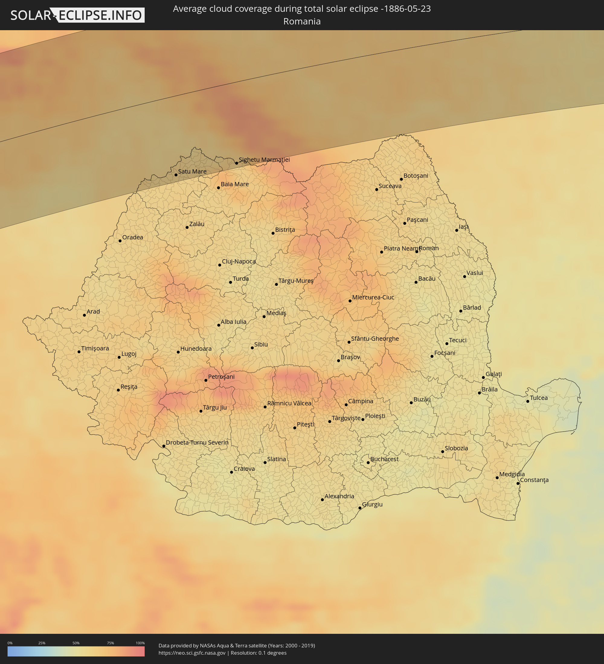
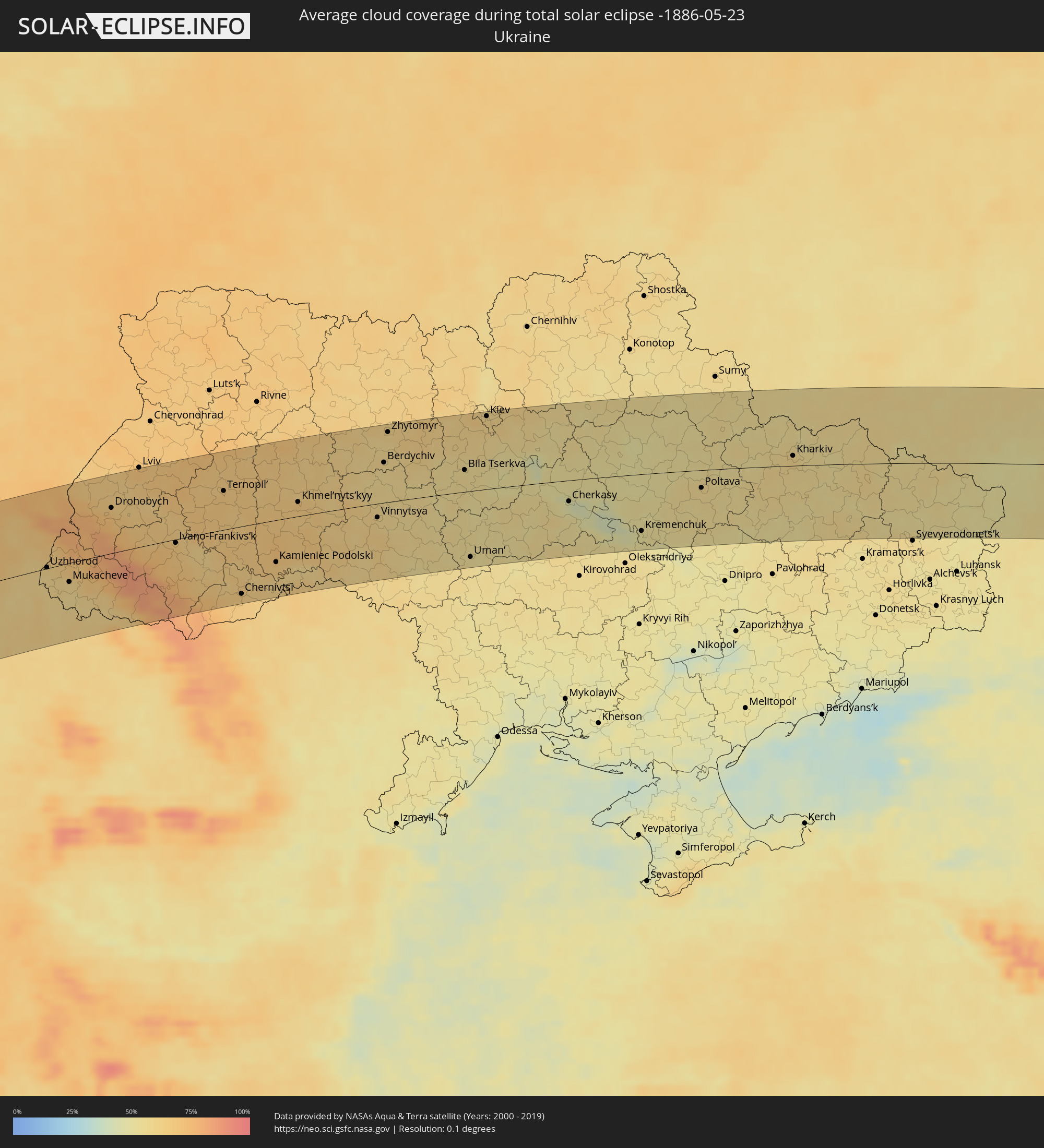
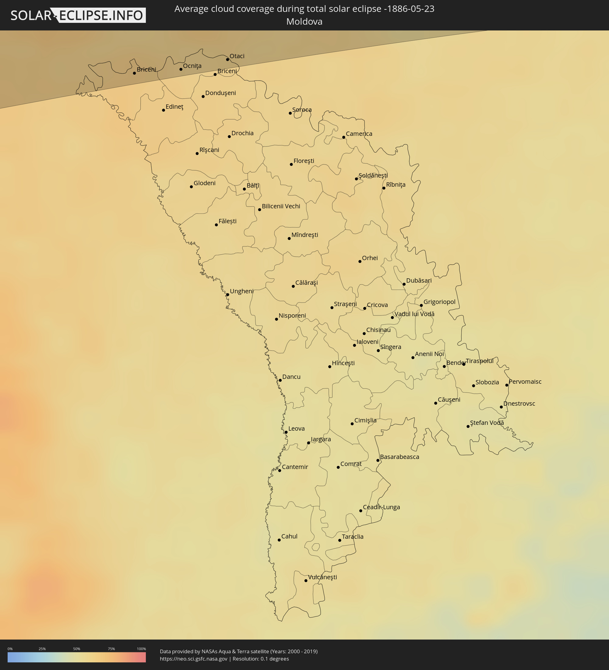
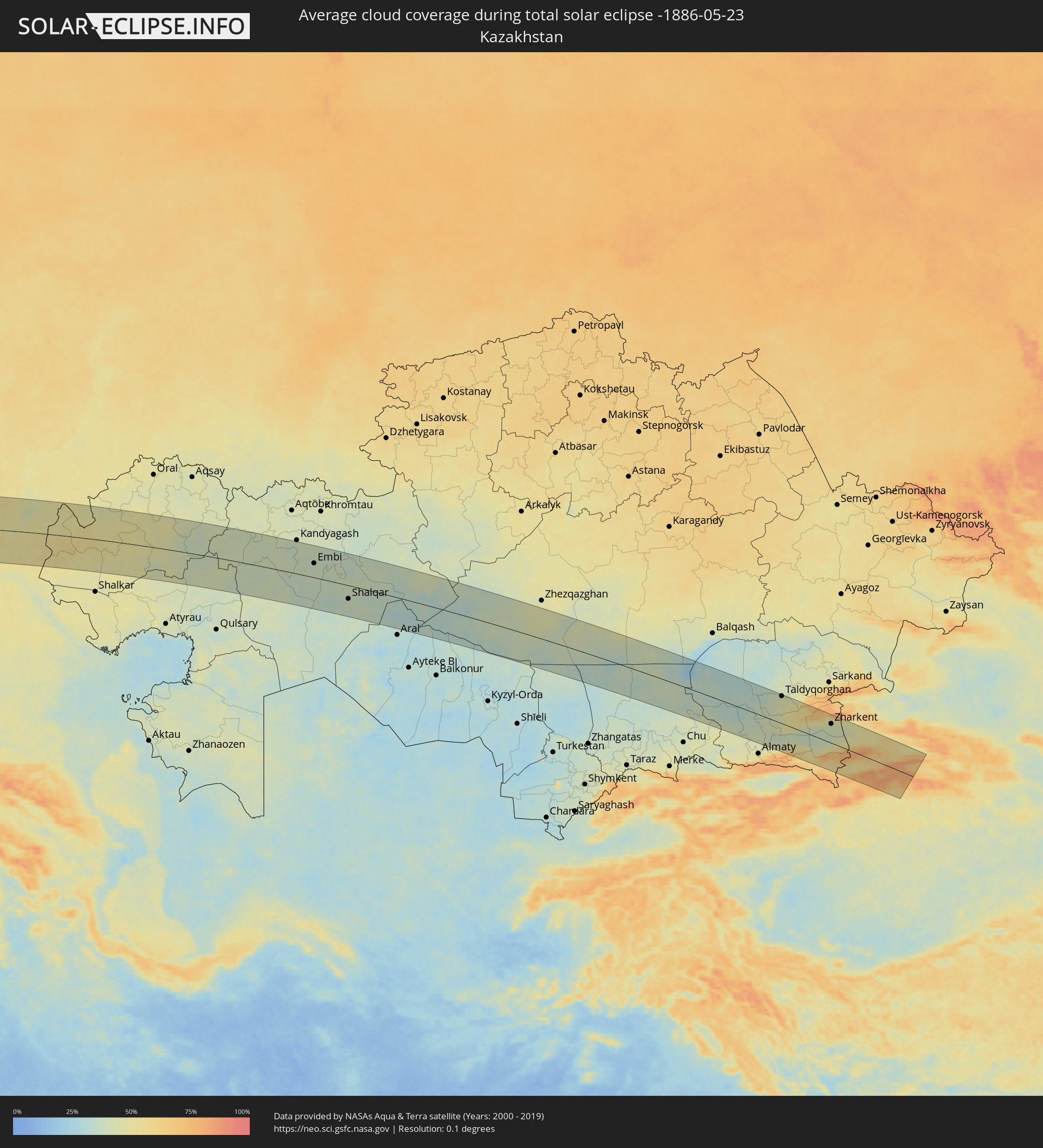
Die folgenden Karten zeigen die durchschnittliche Bewölkung für den Tag, an dem die totale Sonnenfinsternis
stattfindet. Mit Hilfe der Karten lässt sich der Ort entlang des Finsternispfades eingrenzen,
der die besten Aussichen auf einen klaren wolkenfreien Himmel bietet.
Trotzdem muss man immer lokale Gegenenheiten beachten und sollte sich genau über das Wetter an seinem
gewählten Beobachtungsort informieren.
Die Daten stammen von den beiden NASA-Satelliten
AQUA und TERRA
und wurden über einen Zeitraum von 19 Jahren (2000 - 2019) gemittelt.
Detaillierte Länderkarten
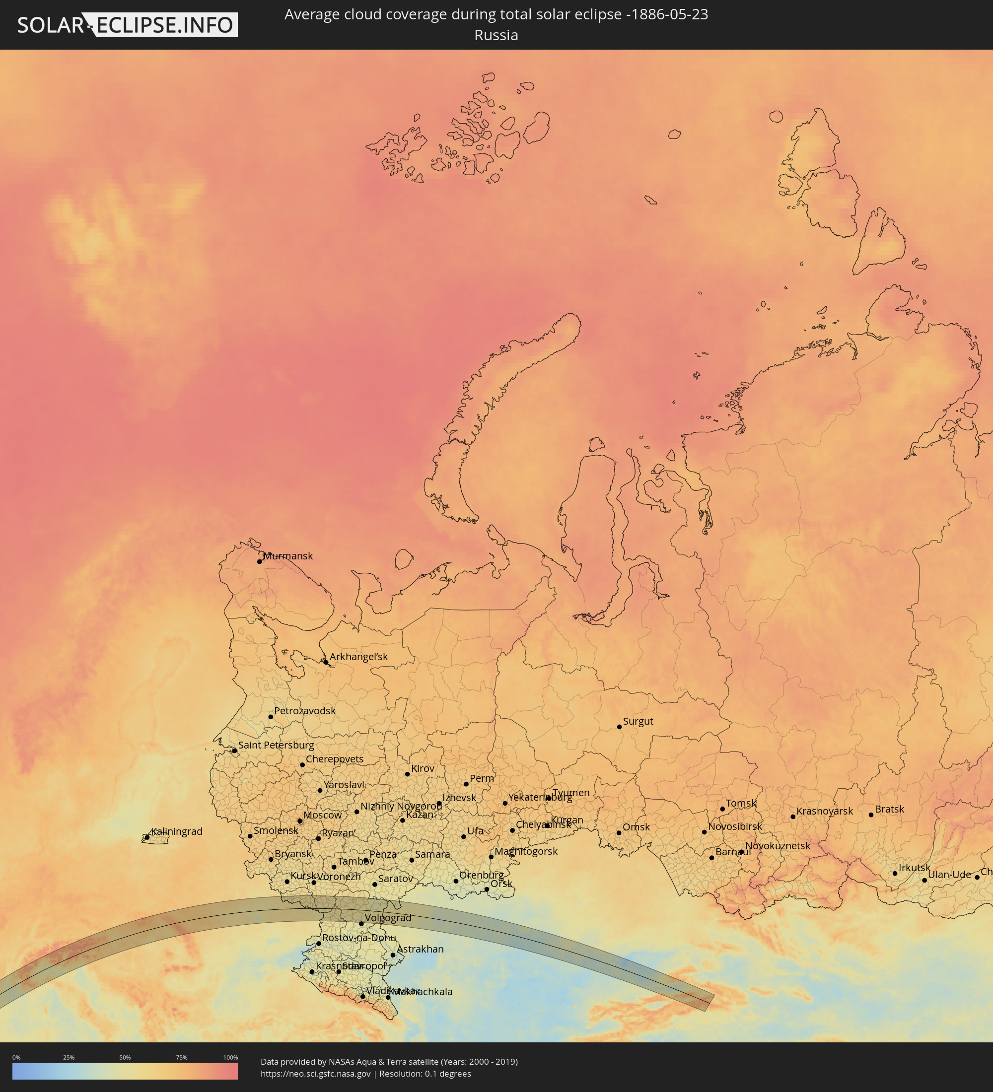 Russland
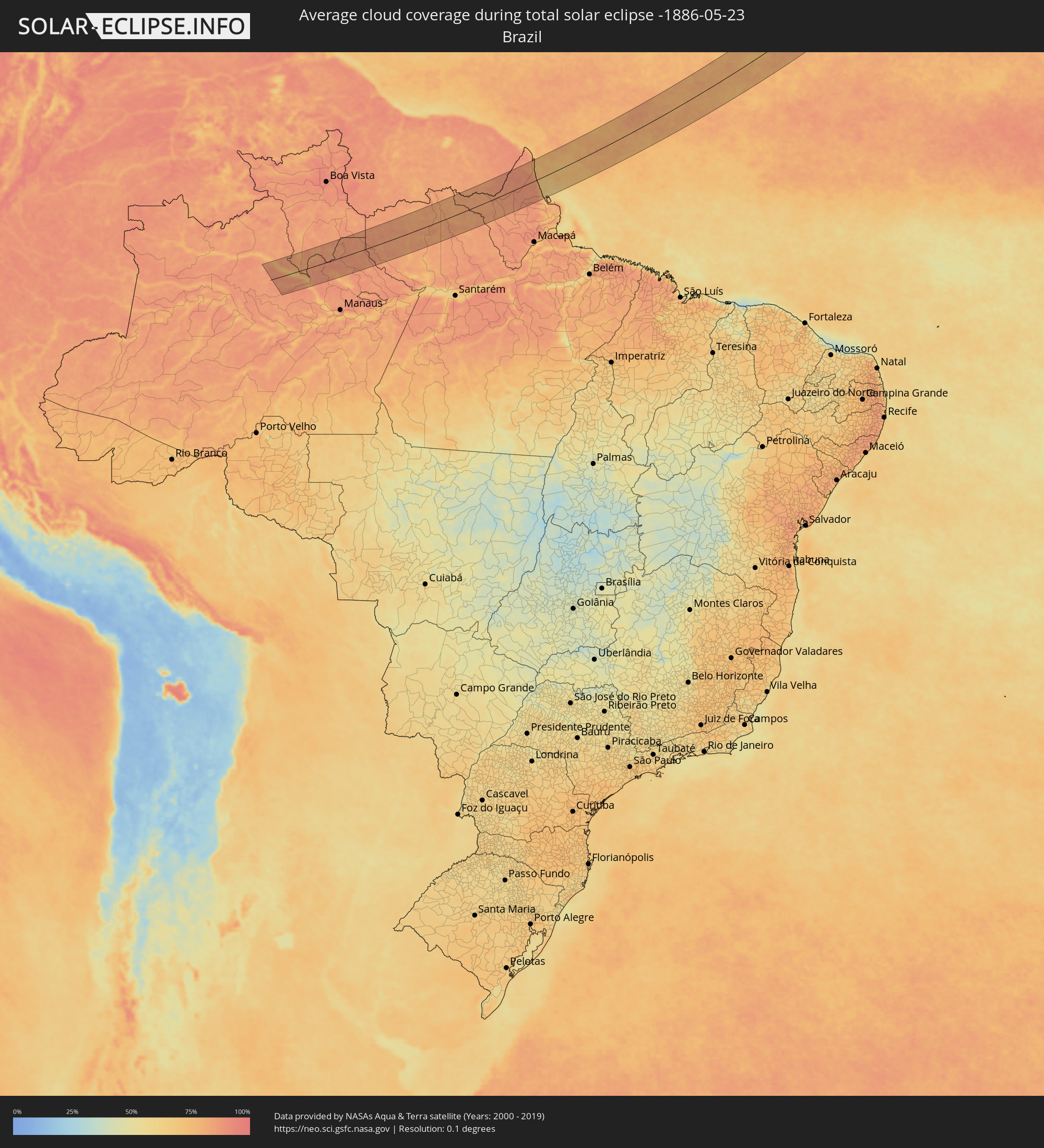 Brasilien
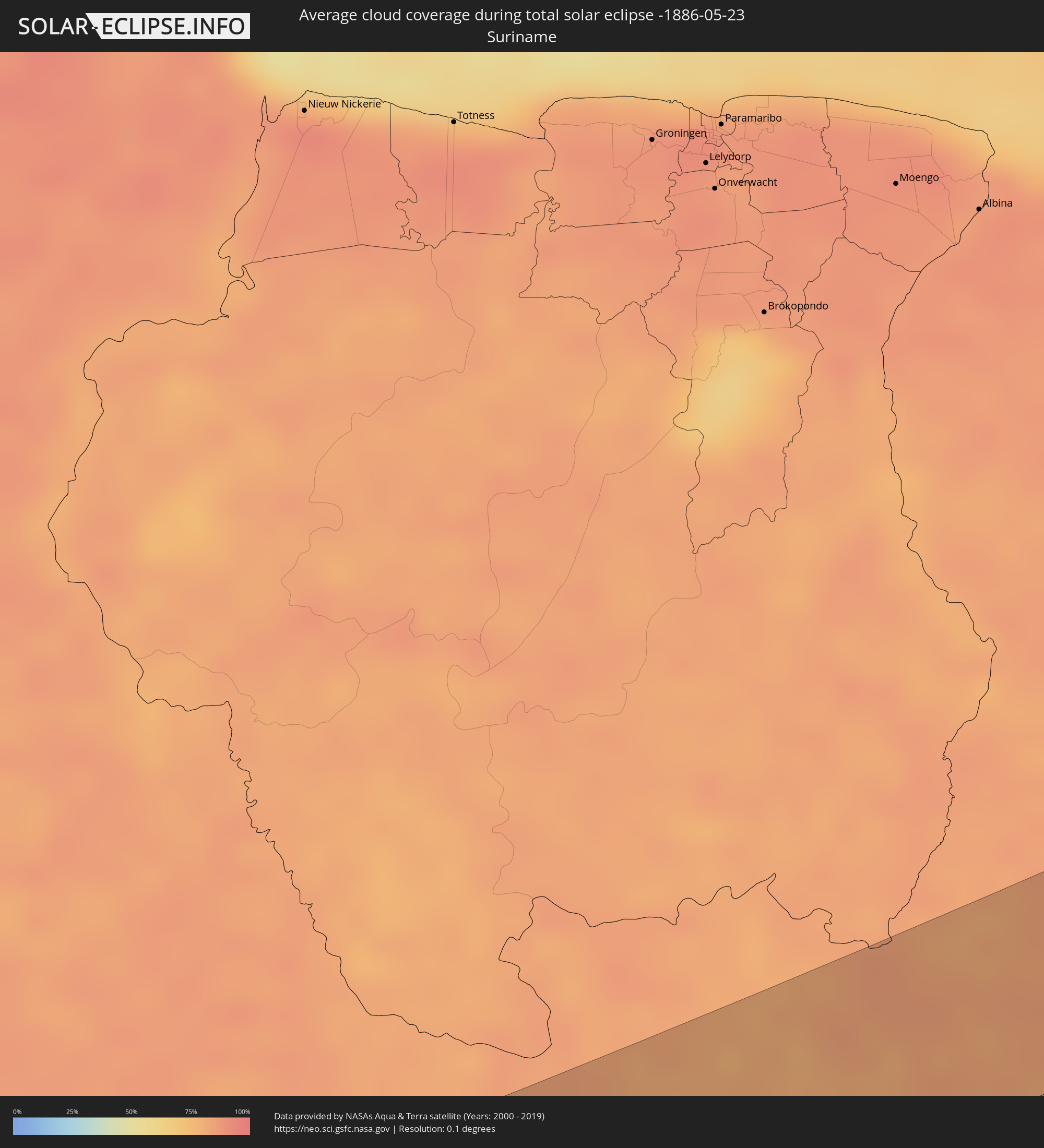 Suriname
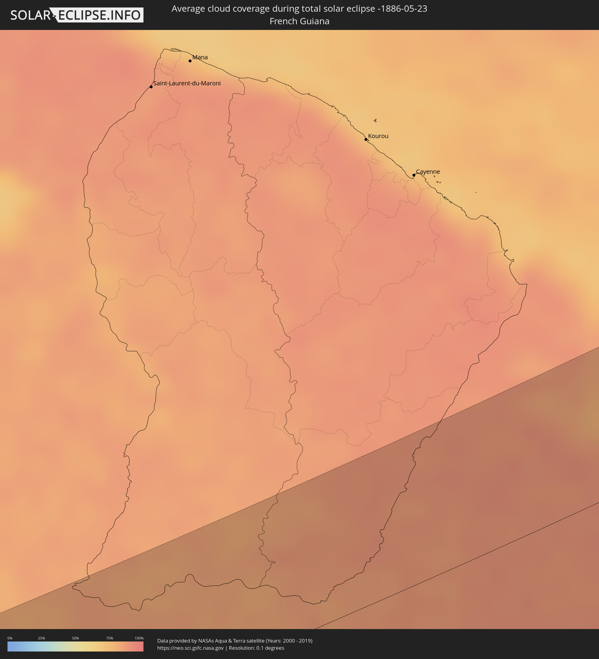 Französisch-Guayana
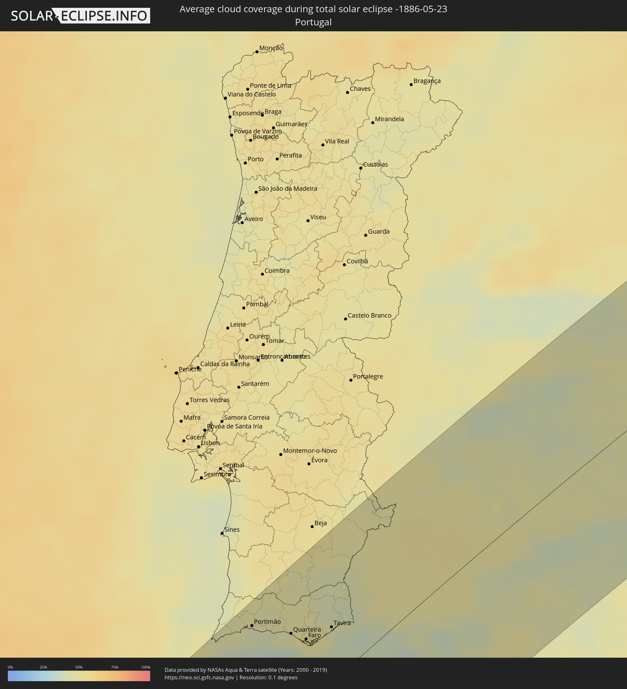 Portugal
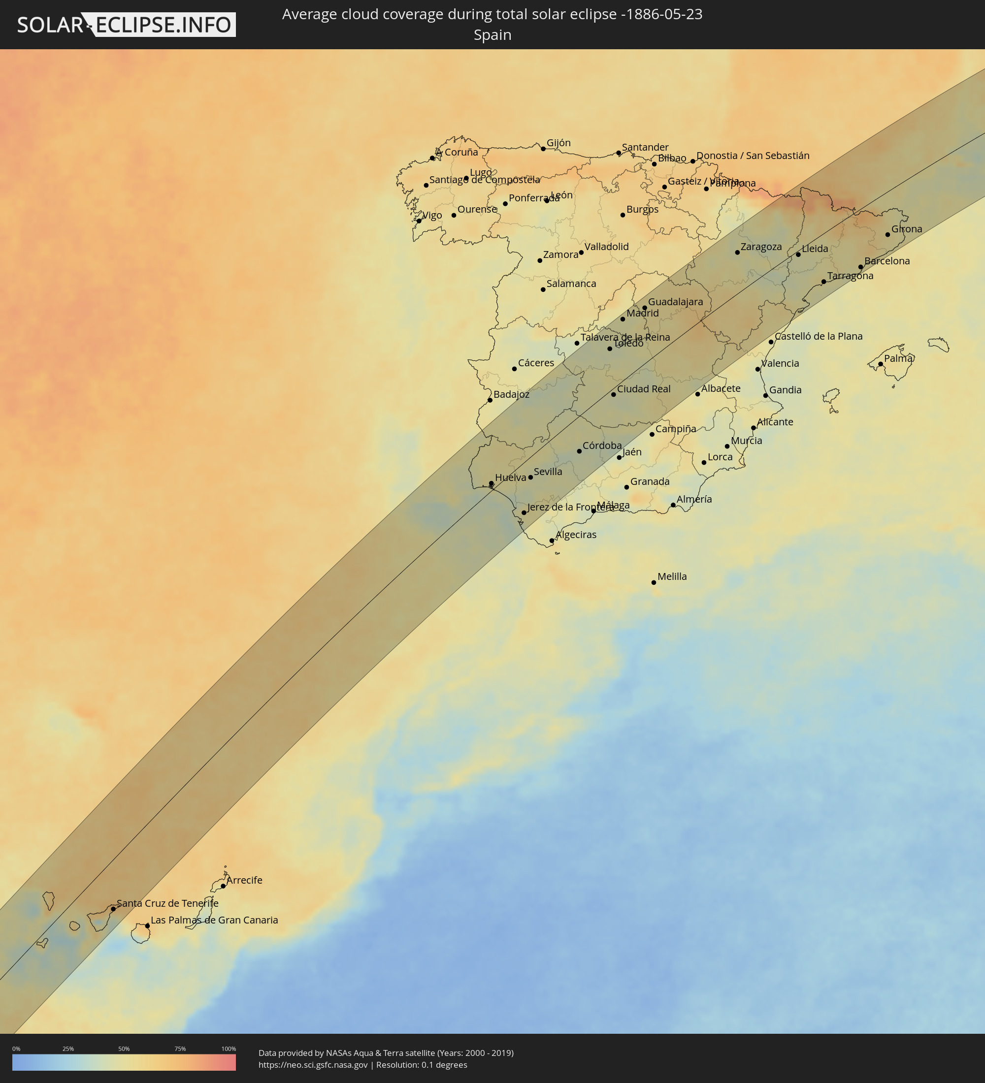 Spanien
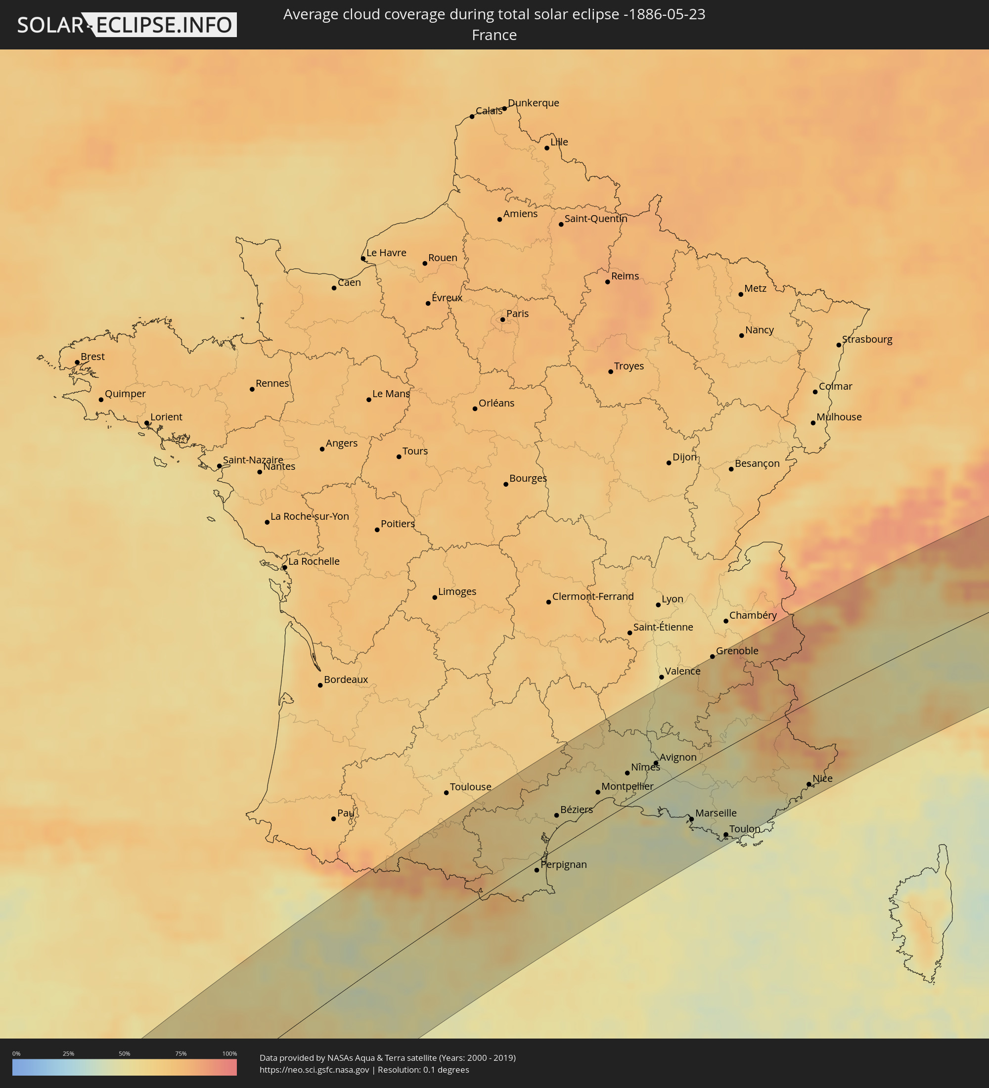 Frankreich
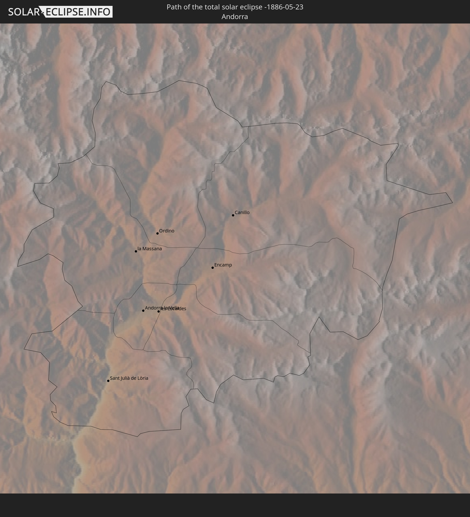
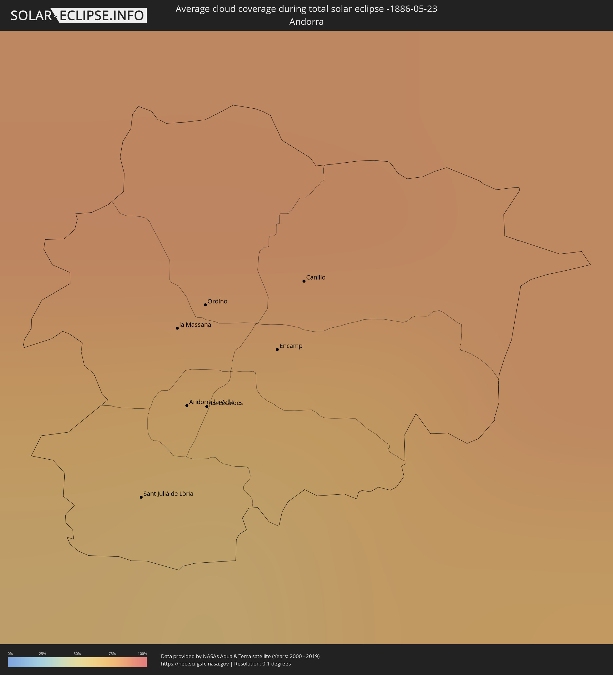 Andorra
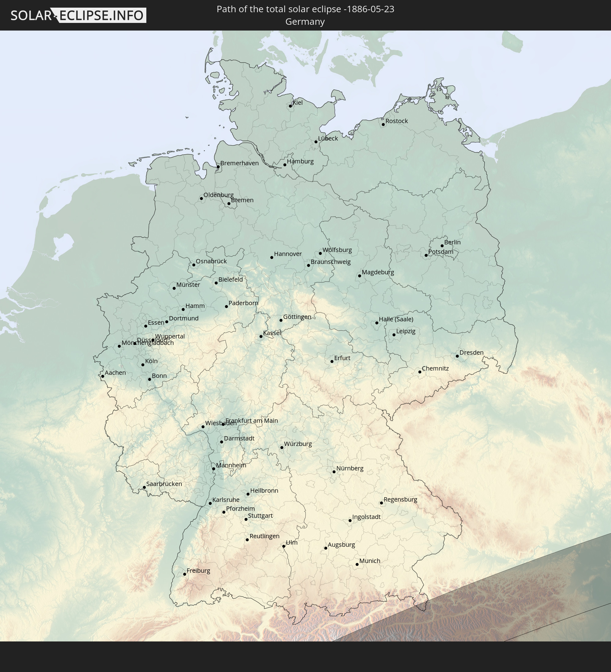
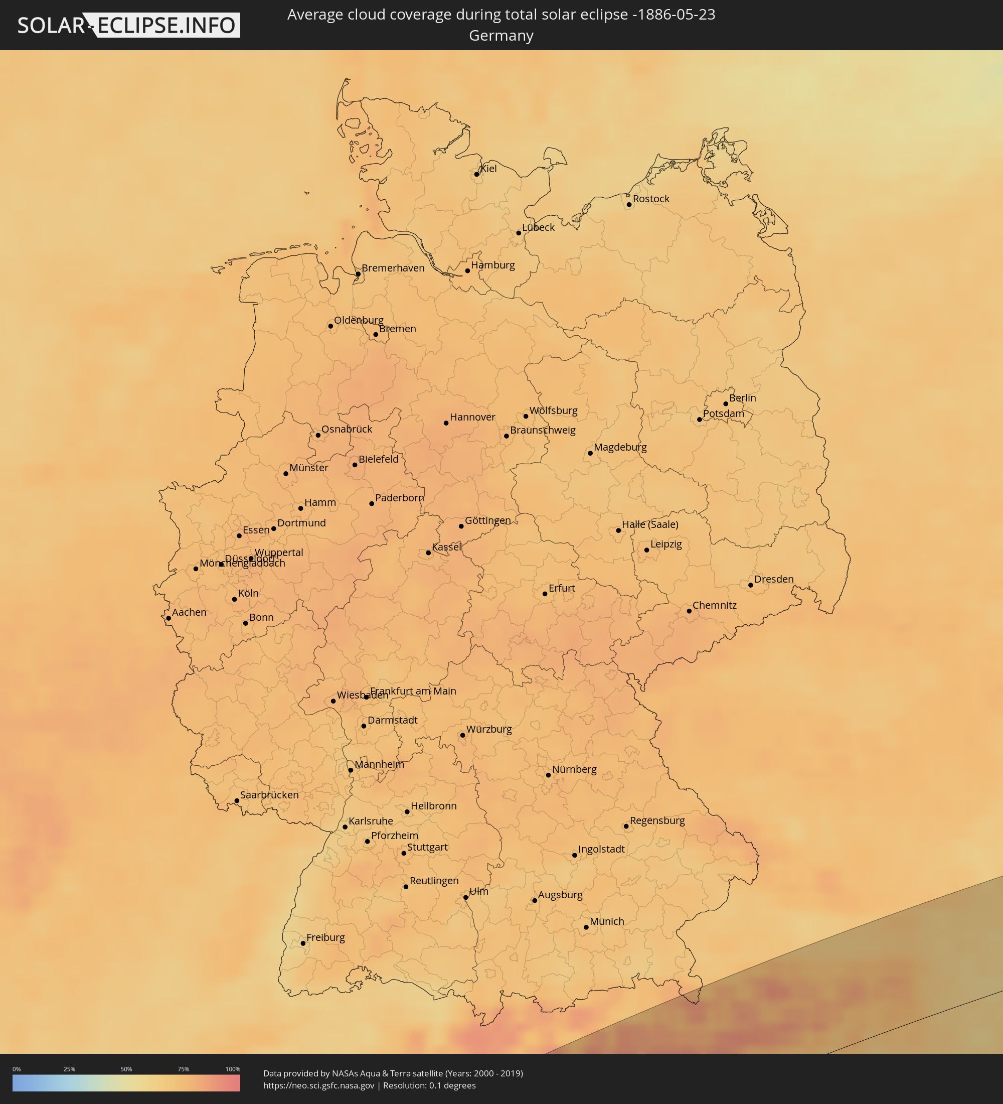 Deutschland
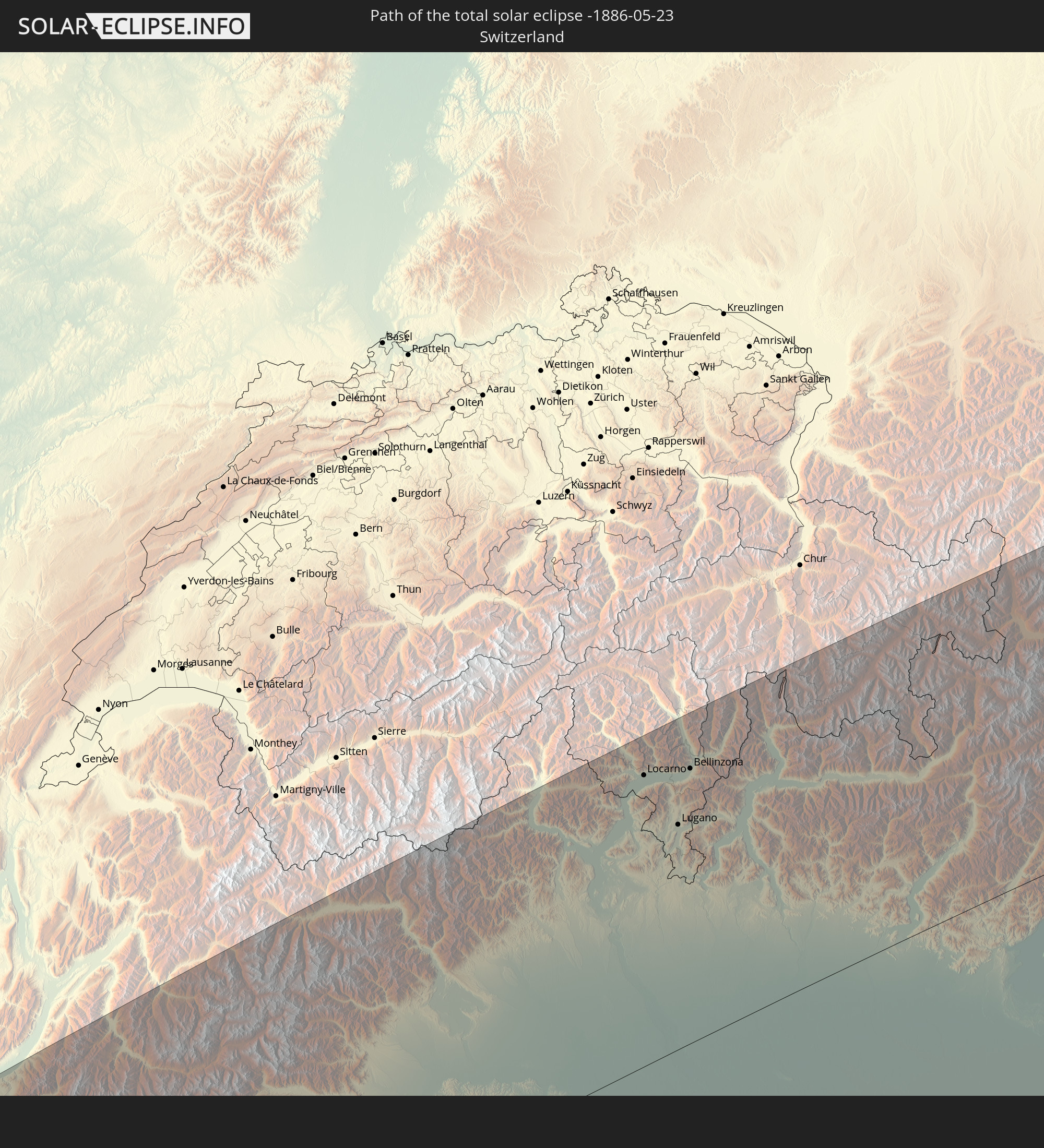
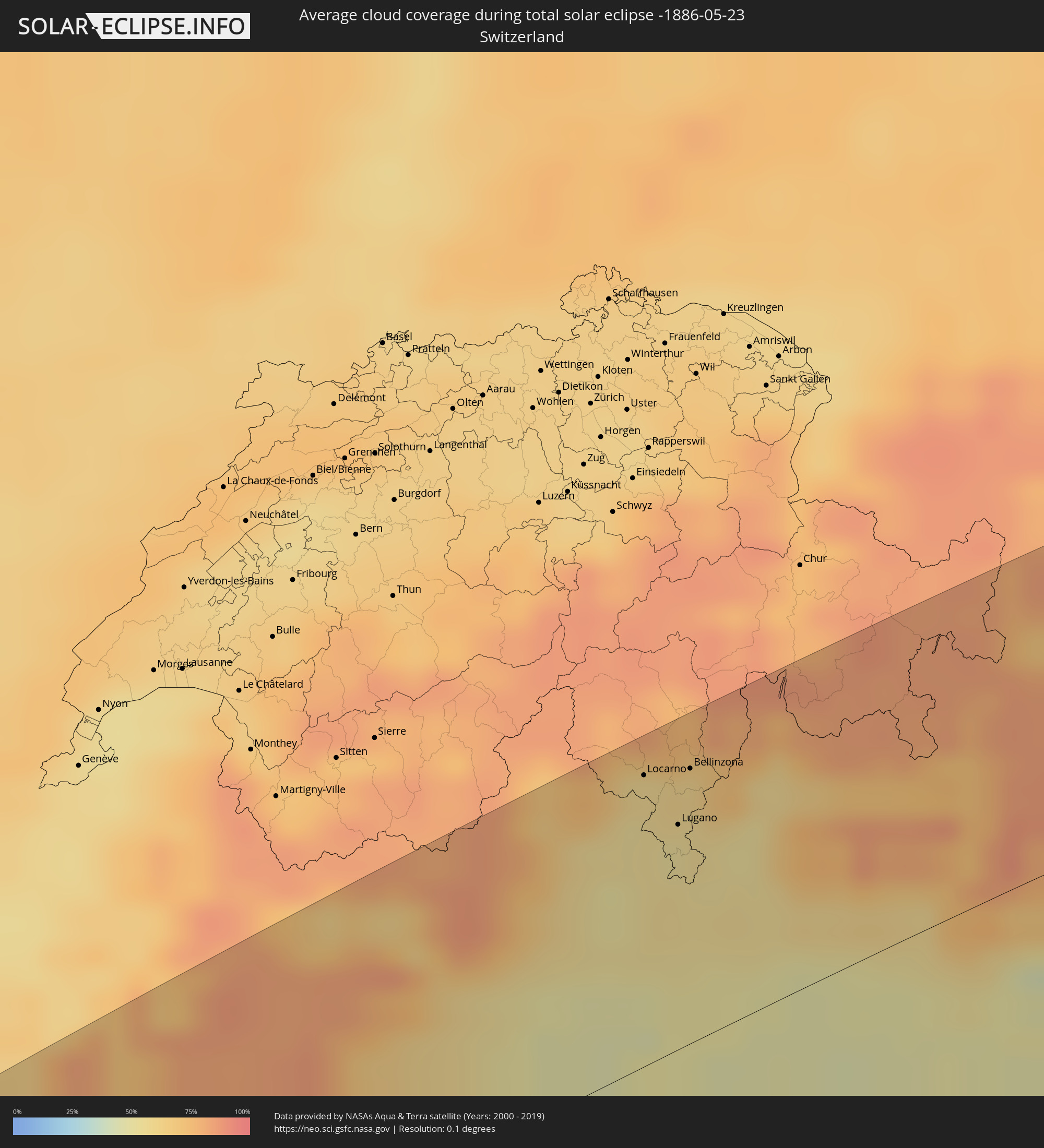 Schweiz
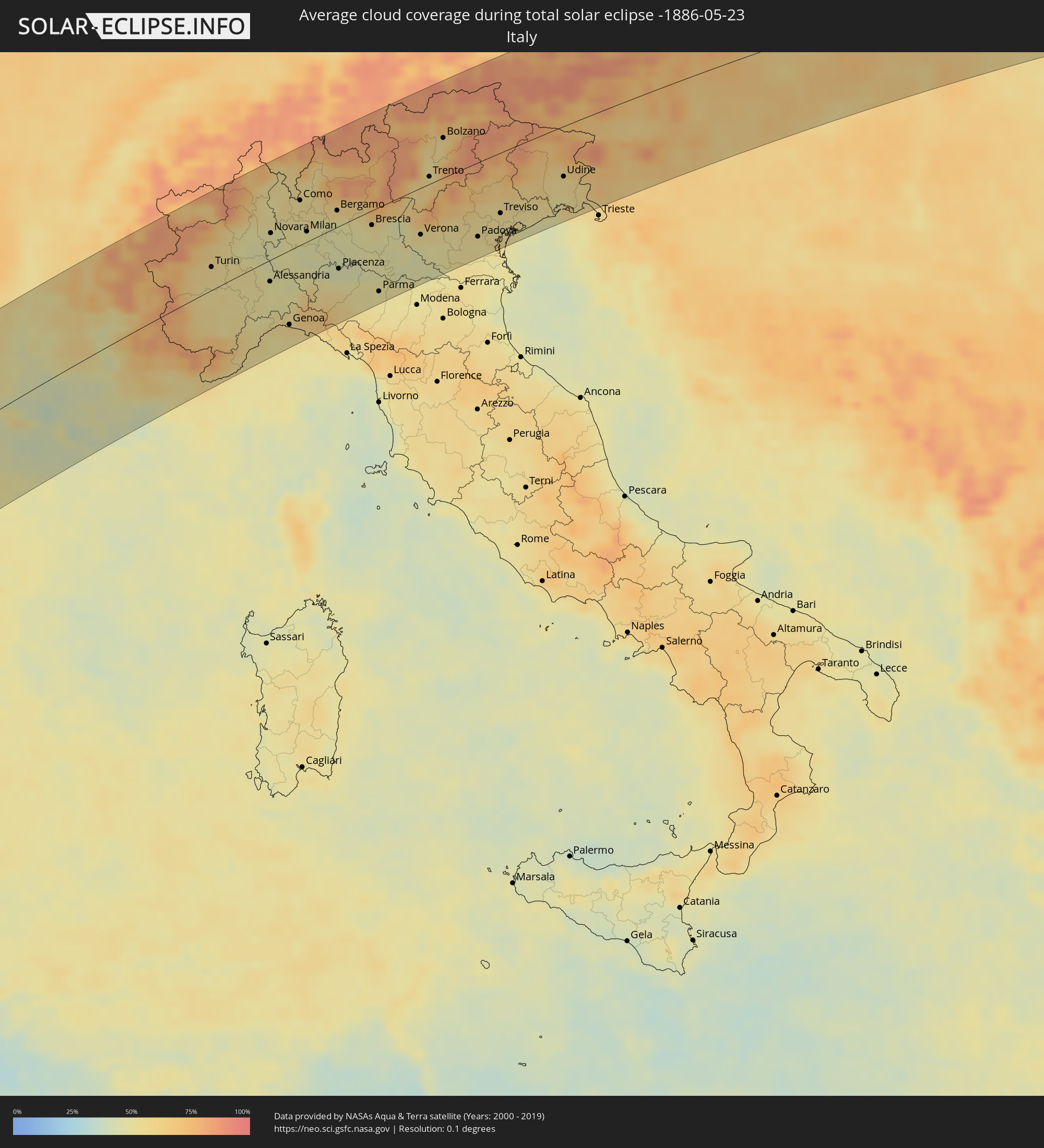 Italien
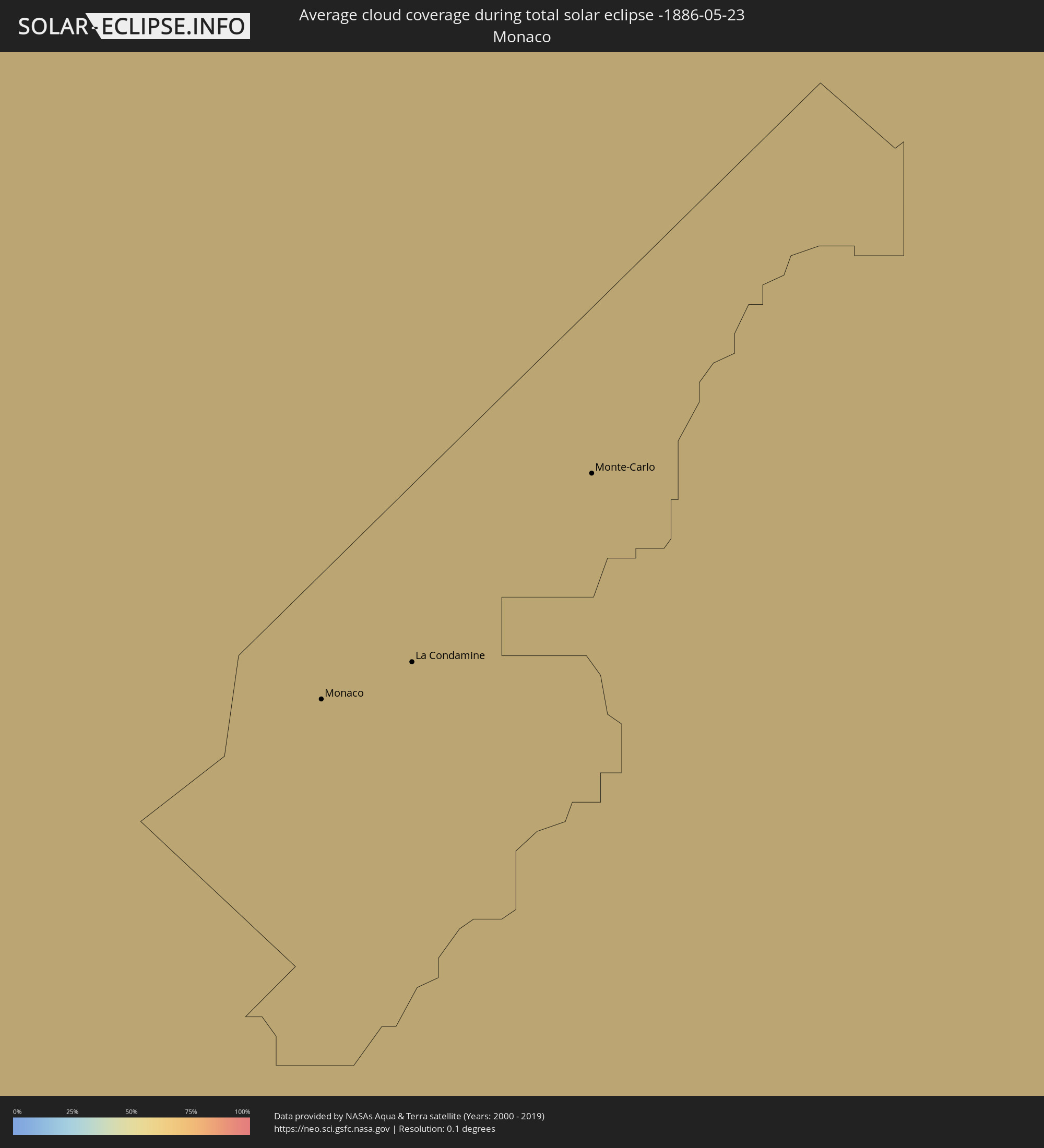 Monaco
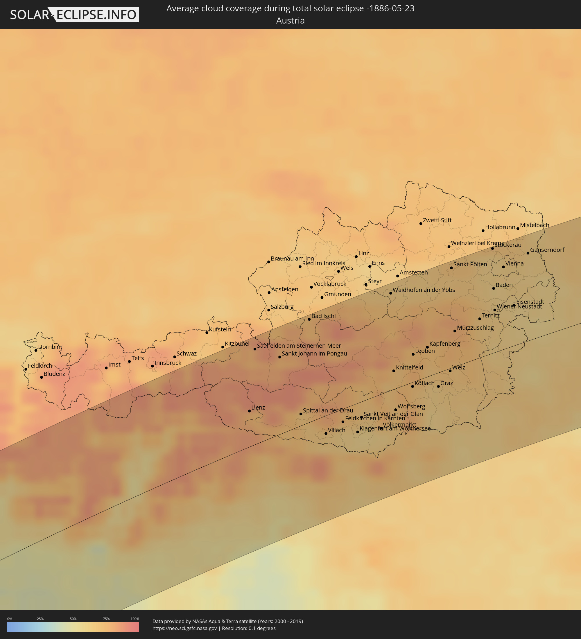 Österreich
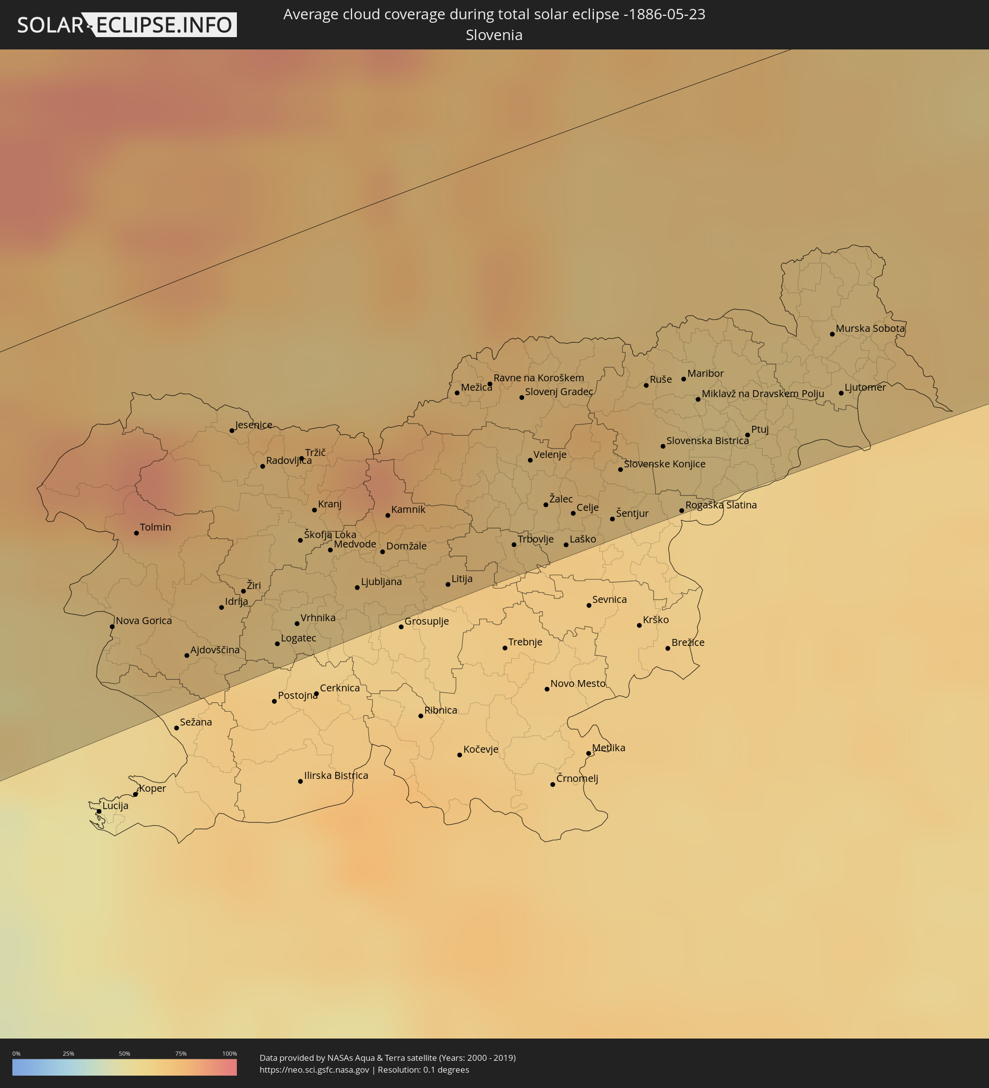 Slowenien
 Kroatien
 Polen
Polen
 Ungarn
 Slowakei
 Rumänien
 Ukraine
 Moldawien
 Kasachstan
 Volksrepublik China
Orte im Finsternispfad
Die nachfolgene Tabelle zeigt Städte und Orte mit mehr als 5.000 Einwohnern, die sich im Finsternispfad befinden. Städte mit mehr als 100.000 Einwohnern sind dick gekennzeichnet. Mit einem Klick auf den Ort öffnet sich eine Detailkarte die die Lage des jeweiligen Ortes zusammen mit dem Verlauf der zentralen Finsternis präsentiert.
| Ort | Typ | Dauer der Verfinsterung | Ortszeit bei maximaler Verfinsterung | Entfernung zur Zentrallinie | Ø Bewölkung |
|
Barcelos, Amazonas
|
total | - | 06:03:05 UTC-04:02 | 67 km | 76% |
|
Santa Cruz de Tenerife, Canary Islands
|
total | - | 10:14:31 UTC-01:01 | 84 km | 57% |
|
Portimão, Faro
|
total | - | 11:07:04 UTC-00:36 | 95 km | 43% |
|
Estômbar, Faro
|
total | - | 11:07:10 UTC-00:36 | 92 km | 43% |
|
Silves, Faro
|
total | - | 11:07:18 UTC-00:36 | 93 km | 47% |
|
São Bartolomeu de Messines, Faro
|
total | - | 11:07:40 UTC-00:36 | 90 km | 45% |
|
Albufeira, Faro
|
total | - | 11:07:26 UTC-00:36 | 73 km | 43% |
|
Almancil, Faro
|
total | - | 11:07:47 UTC-00:36 | 60 km | 49% |
|
Loulé, Faro
|
total | - | 11:07:54 UTC-00:36 | 64 km | 49% |
|
Faro, Faro
|
total | - | 11:07:50 UTC-00:36 | 49 km | 47% |
|
Moncarapacho, Faro
|
total | - | 11:08:11 UTC-00:36 | 46 km | 50% |
|
Tavira, Faro
|
total | - | 11:08:28 UTC-00:36 | 41 km | 42% |
|
Serpa, Beja
|
total | - | 11:09:53 UTC-00:36 | 106 km | 49% |
|
Vila Real de Santo António, Faro
|
total | - | 11:08:57 UTC-00:36 | 33 km | 44% |
|
Huelva, Andalusia
|
total | - | 11:46:36 UTC+00:00 | 11 km | 48% |
|
Jerez de la Frontera, Andalusia
|
total | - | 11:46:59 UTC+00:00 | 85 km | 48% |
|
Sevilla, Andalusia
|
total | - | 11:48:22 UTC+00:00 | 35 km | 46% |
|
Córdoba, Andalusia
|
total | - | 11:51:09 UTC+00:00 | 60 km | 41% |
|
Móstoles, Madrid
|
total | - | 11:56:14 UTC+00:00 | 101 km | 46% |
|
Madrid, Madrid
|
total | - | 11:56:38 UTC+00:00 | 100 km | 47% |
|
Alcalá de Henares, Madrid
|
total | - | 11:57:16 UTC+00:00 | 88 km | 46% |
|
Zaragoza, Aragon
|
total | - | 12:02:51 UTC+00:00 | 67 km | 45% |
|
Tarragona, Catalonia
|
total | - | 12:05:42 UTC+00:00 | 84 km | 47% |
|
Sant Julià de Lòria, Sant Julià de Loria
|
total | - | 12:07:41 UTC+00:00 | 30 km | 65% |
|
la Massana, La Massana
|
total | - | 12:07:48 UTC+00:00 | 36 km | 65% |
|
Andorra la Vella, Andorra la Vella
|
total | - | 12:07:46 UTC+00:00 | 33 km | 65% |
|
Ordino, Ordino
|
total | - | 12:07:51 UTC+00:00 | 36 km | 72% |
|
les Escaldes, Escaldes-Engordany
|
total | - | 12:07:48 UTC+00:00 | 32 km | 65% |
|
Encamp, Encamp
|
total | - | 12:07:54 UTC+00:00 | 32 km | 71% |
|
Canillo, Canillo
|
total | - | 12:07:58 UTC+00:00 | 35 km | 74% |
|
Terrassa, Catalonia
|
total | - | 12:07:31 UTC+00:00 | 78 km | 52% |
|
Barcelona, Catalonia
|
total | - | 12:07:33 UTC+00:00 | 101 km | 52% |
|
Perpignan, Occitania
|
total | - | 12:19:34 UTC+00:09 | 11 km | 50% |
|
Béziers, Occitania
|
total | - | 12:20:46 UTC+00:09 | 36 km | 52% |
|
Montpellier, Occitania
|
total | - | 12:22:06 UTC+00:09 | 33 km | 57% |
|
Nîmes, Occitania
|
total | - | 12:23:04 UTC+00:09 | 35 km | 52% |
|
Arles, Provence-Alpes-Côte d'Azur
|
total | - | 12:23:22 UTC+00:09 | 8 km | 45% |
|
Avignon, Provence-Alpes-Côte d'Azur
|
total | - | 12:23:55 UTC+00:09 | 27 km | 47% |
|
Marseille, Provence-Alpes-Côte d'Azur
|
total | - | 12:24:14 UTC+00:09 | 59 km | 43% |
|
Aix-en-Provence, Provence-Alpes-Côte d'Azur
|
total | - | 12:24:33 UTC+00:09 | 39 km | 42% |
|
Grenoble, Auvergne-Rhône-Alpes
|
total | - | 12:26:24 UTC+00:09 | 109 km | 61% |
|
Toulon, Provence-Alpes-Côte d'Azur
|
total | - | 12:24:58 UTC+00:09 | 98 km | 42% |
|
Antibes, Provence-Alpes-Côte d'Azur
|
total | - | 12:27:18 UTC+00:09 | 102 km | 52% |
|
Nice, Provence-Alpes-Côte d'Azur
|
total | - | 12:27:39 UTC+00:09 | 93 km | 55% |
|
Monaco
|
total | - | 12:27:55 UTC+00:09 | 96 km | 55% |
|
La Condamine
|
total | - | 12:27:55 UTC+00:09 | 96 km | 55% |
|
Monte-Carlo
|
total | - | 12:27:56 UTC+00:09 | 96 km | 55% |
|
Turin, Piedmont
|
total | - | 13:20:03 UTC+01:00 | 25 km | 57% |
|
Losone, Ticino
|
total | - | 13:22:28 UTC+01:00 | 96 km | 58% |
|
Locarno, Ticino
|
total | - | 13:22:32 UTC+01:00 | 95 km | 58% |
|
Minusio, Ticino
|
total | - | 13:22:33 UTC+01:00 | 95 km | 58% |
|
Genoa, Liguria
|
total | - | 13:21:30 UTC+01:00 | 83 km | 57% |
|
Massagno, Ticino
|
total | - | 13:22:39 UTC+01:00 | 74 km | 53% |
|
Lugano, Ticino
|
total | - | 13:22:40 UTC+01:00 | 74 km | 56% |
|
Viganello, Ticino
|
total | - | 13:22:41 UTC+01:00 | 74 km | 56% |
|
Biasca, Ticino
|
total | - | 13:22:54 UTC+01:00 | 108 km | 76% |
|
Pregassona, Ticino
|
total | - | 13:22:42 UTC+01:00 | 74 km | 56% |
|
Mendrisio, Ticino
|
total | - | 13:22:36 UTC+01:00 | 59 km | 54% |
|
Giubiasco, Ticino
|
total | - | 13:22:51 UTC+01:00 | 88 km | 61% |
|
Bellinzona, Ticino
|
total | - | 13:22:52 UTC+01:00 | 90 km | 61% |
|
Chiasso, Ticino
|
total | - | 13:22:39 UTC+01:00 | 53 km | 55% |
|
Milan, Lombardy
|
total | - | 13:22:39 UTC+01:00 | 11 km | 49% |
|
Bergamo, Lombardy
|
total | - | 13:23:33 UTC+01:00 | 18 km | 53% |
|
Brescia, Lombardy
|
total | - | 13:24:17 UTC+01:00 | 16 km | 51% |
|
Parma, Emilia-Romagna
|
total | - | 13:24:00 UTC+01:00 | 94 km | 49% |
|
Verona, Veneto
|
total | - | 13:25:24 UTC+01:00 | 52 km | 51% |
|
Bolzano, Trentino-Alto Adige
|
total | - | 13:26:32 UTC+01:00 | 44 km | 56% |
|
Vicenza, Veneto
|
total | - | 13:26:20 UTC+01:00 | 58 km | 52% |
|
Padova, Veneto
|
total | - | 13:26:47 UTC+01:00 | 83 km | 52% |
|
Mestre, Veneto
|
total | - | 13:27:23 UTC+01:00 | 86 km | 53% |
|
Saalfelden am Steinernen Meer, Salzburg
|
total | - | 13:29:11 UTC+01:00 | 95 km | 76% |
|
Udine, Friuli Venezia Giulia
|
total | - | 13:29:10 UTC+01:00 | 56 km | 56% |
|
Spittal an der Drau, Carinthia
|
total | - | 13:29:52 UTC+01:00 | 11 km | 71% |
|
Nova Gorica, Nova Gorica
|
total | - | 13:29:44 UTC+01:00 | 80 km | 60% |
|
Villach, Carinthia
|
total | - | 13:30:19 UTC+01:00 | 18 km | 65% |
|
Jesenice, Jesenice
|
total | - | 13:30:33 UTC+01:00 | 43 km | 67% |
|
Logatec, Logatec
|
total | - | 13:30:35 UTC+01:00 | 101 km | 65% |
|
Klagenfurt am Wörthersee, Carinthia
|
total | - | 13:30:59 UTC+01:00 | 29 km | 62% |
|
Kranj, Kranj
|
total | - | 13:30:54 UTC+01:00 | 71 km | 64% |
|
Ljubljana, Ljubljana
|
total | - | 13:31:03 UTC+01:00 | 95 km | 62% |
|
Kamnik, Kamnik
|
total | - | 13:31:17 UTC+01:00 | 79 km | 67% |
|
Wolfsberg, Carinthia
|
total | - | 13:31:51 UTC+01:00 | 22 km | 66% |
|
Trbovlje, Trbovlje
|
total | - | 13:31:55 UTC+01:00 | 99 km | 65% |
|
Leoben, Styria
|
total | - | 13:32:23 UTC+01:00 | 27 km | 73% |
|
Velenje, Velenje
|
total | - | 13:32:04 UTC+01:00 | 79 km | 63% |
|
Celje, Celje
|
total | - | 13:32:15 UTC+01:00 | 97 km | 66% |
|
Kapfenberg, Styria
|
total | - | 13:32:41 UTC+01:00 | 29 km | 71% |
|
Graz, Styria
|
total | - | 13:32:48 UTC+01:00 | 14 km | 65% |
|
Sankt Pölten, Lower Austria
|
total | - | 13:33:23 UTC+01:00 | 100 km | 67% |
|
Maribor, Maribor
|
total | - | 13:32:55 UTC+01:00 | 73 km | 63% |
|
Ptuj, Ptuj
|
total | - | 13:33:12 UTC+01:00 | 93 km | 59% |
|
Murska Sobota, Murska Sobota
|
total | - | 13:33:43 UTC+01:00 | 75 km | 62% |
|
Baden, Lower Austria
|
total | - | 13:34:10 UTC+01:00 | 64 km | 63% |
|
Wiener Neustadt, Lower Austria
|
total | - | 13:34:08 UTC+01:00 | 42 km | 65% |
|
Vienna, Vienna
|
total | - | 13:34:24 UTC+01:00 | 82 km | 63% |
|
Szombathely, Vas
|
total | - | 13:34:31 UTC+01:00 | 27 km | 62% |
|
Zalaegerszeg, Zala
|
total | - | 13:34:44 UTC+01:00 | 74 km | 66% |
|
Bratislava, Bratislavský
|
total | - | 13:35:24 UTC+01:00 | 58 km | 60% |
|
Trnava, Trnavský
|
total | - | 13:36:06 UTC+01:00 | 71 km | 67% |
|
Győr, Győr-Moson-Sopron
|
total | - | 13:36:02 UTC+01:00 | 3 km | 64% |
|
Veszprém, Veszprém
|
total | - | 13:36:19 UTC+01:00 | 72 km | 64% |
|
Nitra, Nitriansky
|
total | - | 13:36:46 UTC+01:00 | 52 km | 64% |
|
Nové Zámky, Nitriansky
|
total | - | 13:36:49 UTC+01:00 | 17 km | 63% |
|
Tatabánya, Komárom-Esztergom
|
total | - | 13:37:04 UTC+01:00 | 31 km | 64% |
|
Székesfehérvár, Fejér
|
total | - | 13:37:02 UTC+01:00 | 74 km | 64% |
|
Prievidza, Nitriansky
|
total | - | 13:37:33 UTC+01:00 | 90 km | 71% |
|
Budapest, Budapest
|
total | - | 13:37:57 UTC+01:00 | 55 km | 64% |
|
Zvolen, Banskobystrický
|
total | - | 13:38:13 UTC+01:00 | 58 km | 69% |
|
Banská Bystrica, Banskobystrický
|
total | - | 13:38:14 UTC+01:00 | 75 km | 69% |
|
Budapest XVII. kerület, Budapest
|
total | - | 13:38:14 UTC+01:00 | 61 km | 63% |
|
Parádsasvár, Heves
|
total | - | 13:39:16 UTC+01:00 | 30 km | 69% |
|
Poprad, Prešovský
|
total | - | 13:39:45 UTC+01:00 | 86 km | 73% |
|
Spišská Nová Ves, Košický
|
total | - | 13:40:05 UTC+01:00 | 69 km | 75% |
|
Miskolc, Borsod-Abaúj-Zemplén
|
total | - | 13:40:21 UTC+01:00 | 26 km | 63% |
|
Prešov, Prešovský
|
total | - | 13:40:57 UTC+01:00 | 62 km | 70% |
|
Košice, Košický
|
total | - | 13:40:59 UTC+01:00 | 31 km | 68% |
|
Debrecen, Hajdú-Bihar
|
total | - | 13:41:28 UTC+01:00 | 104 km | 61% |
|
Nyíregyháza, Szabolcs-Szatmár-Bereg
|
total | - | 13:41:35 UTC+01:00 | 60 km | 62% |
|
Michalovce, Košický
|
total | - | 13:41:50 UTC+01:00 | 23 km | 63% |
|
Sanok, Subcarpathian Voivodeship
|
total | - | 14:06:09 UTC+01:24 | 104 km | 72% |
|
Zagórz, Subcarpathian Voivodeship
|
total | - | 14:06:14 UTC+01:24 | 99 km | 72% |
|
Lesko, Subcarpathian Voivodeship
|
total | - | 14:06:19 UTC+01:24 | 93 km | 72% |
|
Carei, Satu Mare
|
total | - | 14:26:58 UTC+01:44 | 103 km | 59% |
|
Ustrzyki Dolne, Subcarpathian Voivodeship
|
total | - | 14:06:39 UTC+01:24 | 84 km | 75% |
|
Satu Mare, Satu Mare
|
total | - | 14:27:29 UTC+01:44 | 97 km | 61% |
|
Lazuri, Satu Mare
|
total | - | 14:27:29 UTC+01:44 | 92 km | 60% |
|
Halmeu, Satu Mare
|
total | - | 14:27:41 UTC+01:44 | 82 km | 61% |
|
Livada, Satu Mare
|
total | - | 14:27:50 UTC+01:44 | 94 km | 62% |
|
Medieşu Aurit, Satu Mare
|
total | - | 14:27:52 UTC+01:44 | 104 km | 62% |
|
Turţ, Satu Mare
|
total | - | 14:27:56 UTC+01:44 | 83 km | 62% |
|
Oraşu Nou, Satu Mare
|
total | - | 14:28:02 UTC+01:44 | 101 km | 62% |
|
Bixad, Satu Mare
|
total | - | 14:28:11 UTC+01:44 | 92 km | 66% |
|
Negreşti-Oaş, Satu Mare
|
total | - | 14:28:13 UTC+01:44 | 99 km | 66% |
|
Certeze, Satu Mare
|
total | - | 14:28:16 UTC+01:44 | 96 km | 72% |
|
Sighetu Marmaţiei, Maramureş
|
total | - | 14:28:48 UTC+01:44 | 100 km | 64% |
|
Ivano-Frankivs’k, Ivano-Frankivsk
|
total | - | 14:47:23 UTC+02:02 | 5 km | 68% |
|
Ternopil’, Ternopil
|
total | - | 14:48:20 UTC+02:02 | 52 km | 68% |
|
Chernivtsi, Chernivtsi
|
total | - | 14:48:59 UTC+02:02 | 91 km | 66% |
|
Khmel’nyts’kyy, Khmelnytskyi
|
total | - | 14:50:00 UTC+02:02 | 19 km | 66% |
|
Briceni, Briceni
|
total | - | 14:43:17 UTC+01:55 | 98 km | 64% |
|
Ocniţa, Raionul Ocniţa
|
total | - | 14:43:42 UTC+01:55 | 100 km | 63% |
|
Otaci, Raionul Ocniţa
|
total | - | 14:44:07 UTC+01:55 | 99 km | 60% |
|
Vinnytsya, Vinnyts'ka
|
total | - | 14:51:45 UTC+02:02 | 19 km | 61% |
|
Zhytomyr, Zhytomyr
|
total | - | 14:51:38 UTC+02:02 | 93 km | 61% |
|
Bila Tserkva, Kiev
|
total | - | 14:53:21 UTC+02:02 | 29 km | 57% |
|
Kiev, Kyiv City
|
total | - | 14:53:32 UTC+02:02 | 97 km | 62% |
|
Cherkasy, Cherkasy
|
total | - | 14:55:35 UTC+02:02 | 28 km | 47% |
|
Kremenchuk, Poltava
|
total | - | 14:57:09 UTC+02:02 | 77 km | 50% |
|
Poltava, Poltava
|
total | - | 14:58:01 UTC+02:02 | 24 km | 57% |
|
Kharkiv, Kharkiv
|
total | - | 14:59:26 UTC+02:02 | 13 km | 60% |
|
Belgorod, Belgorod
|
total | - | 15:27:34 UTC+02:30 | 83 km | 58% |
|
Shebekino, Belgorod
|
total | - | 15:28:00 UTC+02:30 | 60 km | 57% |
|
Novyy Oskol, Belgorod
|
total | - | 15:28:37 UTC+02:30 | 98 km | 59% |
|
Valuyki, Belgorod
|
total | - | 15:29:11 UTC+02:30 | 35 km | 55% |
|
Alekseyevka, Belgorod
|
total | - | 15:29:24 UTC+02:30 | 82 km | 55% |
|
Rossosh’, Voronezj
|
total | - | 15:30:26 UTC+02:30 | 34 km | 54% |
|
Pavlovsk, Voronezj
|
total | - | 15:30:42 UTC+02:30 | 64 km | 55% |
|
Kalach, Voronezj
|
total | - | 15:31:28 UTC+02:30 | 61 km | 55% |
|
Mikhaylovka, Volgograd
|
total | - | 15:33:26 UTC+02:30 | 27 km | 56% |
|
Frolovo, Volgograd
|
total | - | 15:33:58 UTC+02:30 | 3 km | 55% |
|
Kotovo, Volgograd
|
total | - | 15:34:21 UTC+02:30 | 63 km | 51% |
|
Kamyshin, Volgograd
|
total | - | 15:34:57 UTC+02:30 | 42 km | 50% |
|
Īnderbor, Atyraū
|
total | - | 16:35:16 UTC+03:25 | 75 km | 44% |
|
Shubarkuduk, Aqtöbe
|
total | - | 16:36:56 UTC+03:25 | 51 km | 40% |
|
Embi, Aqtöbe
|
total | - | 16:37:52 UTC+03:25 | 43 km | 38% |
|
Shalqar, Aqtöbe
|
total | - | 16:39:17 UTC+03:25 | 41 km | 39% |
|
Sekseūil, Qyzylorda
|
total | - | 17:36:55 UTC+04:21 | 94 km | 35% |
|
Priozersk
|
total | - | 17:39:36 UTC+04:21 | 77 km | 29% |
|
Kapshagay, Almaty Oblysy
|
total | - | 17:41:16 UTC+04:21 | 57 km | 40% |
|
Taldyqorghan, Almaty Oblysy
|
total | - | 17:40:15 UTC+04:21 | 85 km | 44% |
|
Saryozek, Almaty Oblysy
|
total | - | 17:40:46 UTC+04:21 | 21 km | 44% |
|
Balpyk Bī, Almaty Oblysy
|
total | - | 17:40:18 UTC+04:21 | 84 km | 44% |
|
Kegen, Almaty Oblysy
|
total | - | 17:41:42 UTC+04:21 | 82 km | 58% |
|
Zharkent, Almaty Oblysy
|
total | - | 17:40:40 UTC+04:21 | 60 km | 41% |