Totale Sonnenfinsternis vom 10.06.0001
| Wochentag: | Sonntag |
| Maximale Dauer der Verfinsterung: | 04m56s |
| Maximale Breite des Finsternispfades: | 218 km |
| Saroszyklus: | 66 |
| Bedeckungsgrad: | 100% |
| Magnitude: | 1.0617 |
| Gamma: | 0.3625 |
Wo kann man die Sonnenfinsternis vom 10.06.0001 sehen?
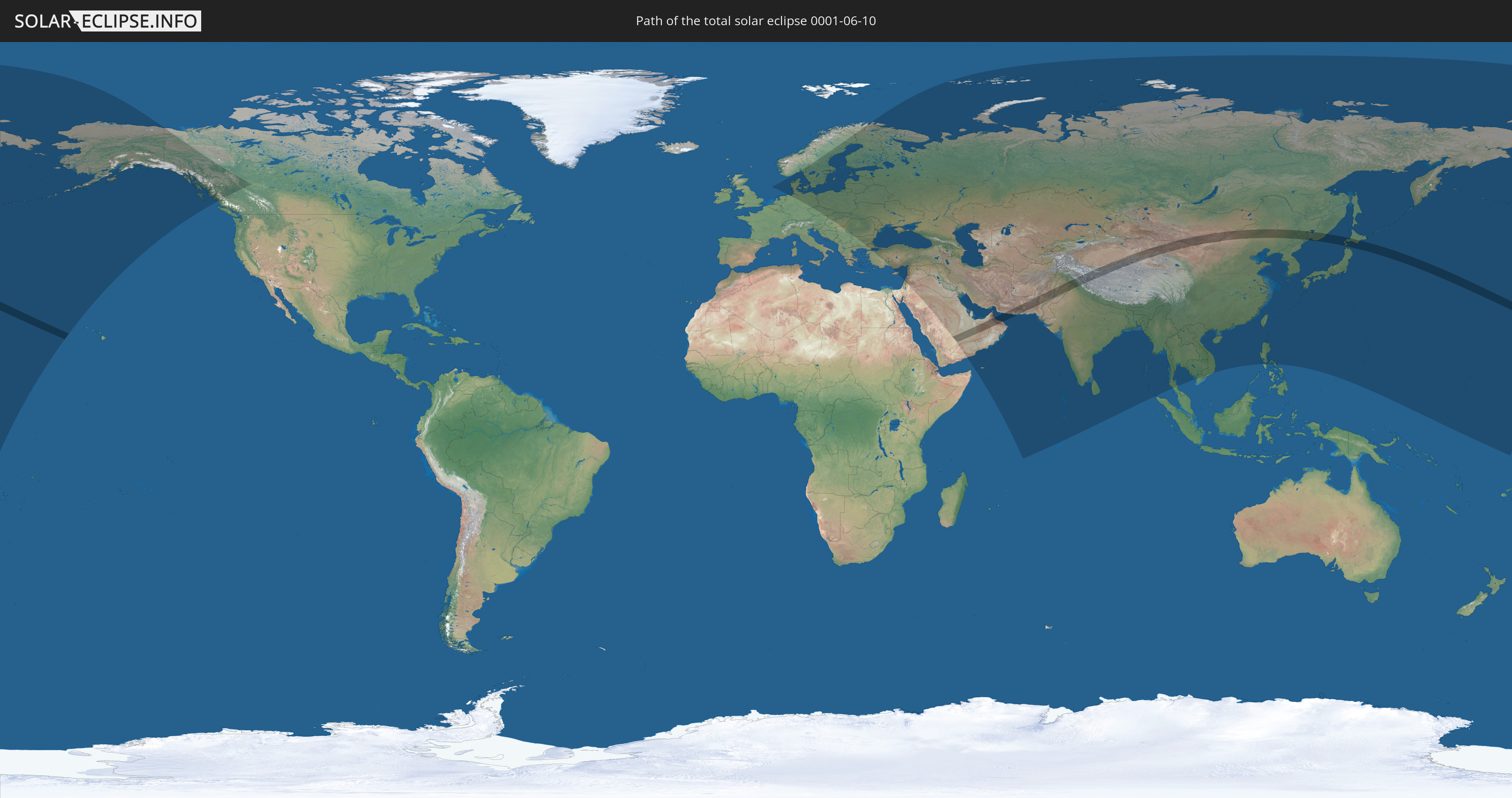
Die Sonnenfinsternis am 10.06.0001 kann man in 79 Ländern als partielle Sonnenfinsternis beobachten.
Der Finsternispfad verläuft durch 10 Länder. Nur in diesen Ländern ist sie als totale Sonnenfinsternis zu sehen.
In den folgenden Ländern ist die Sonnenfinsternis total zu sehen
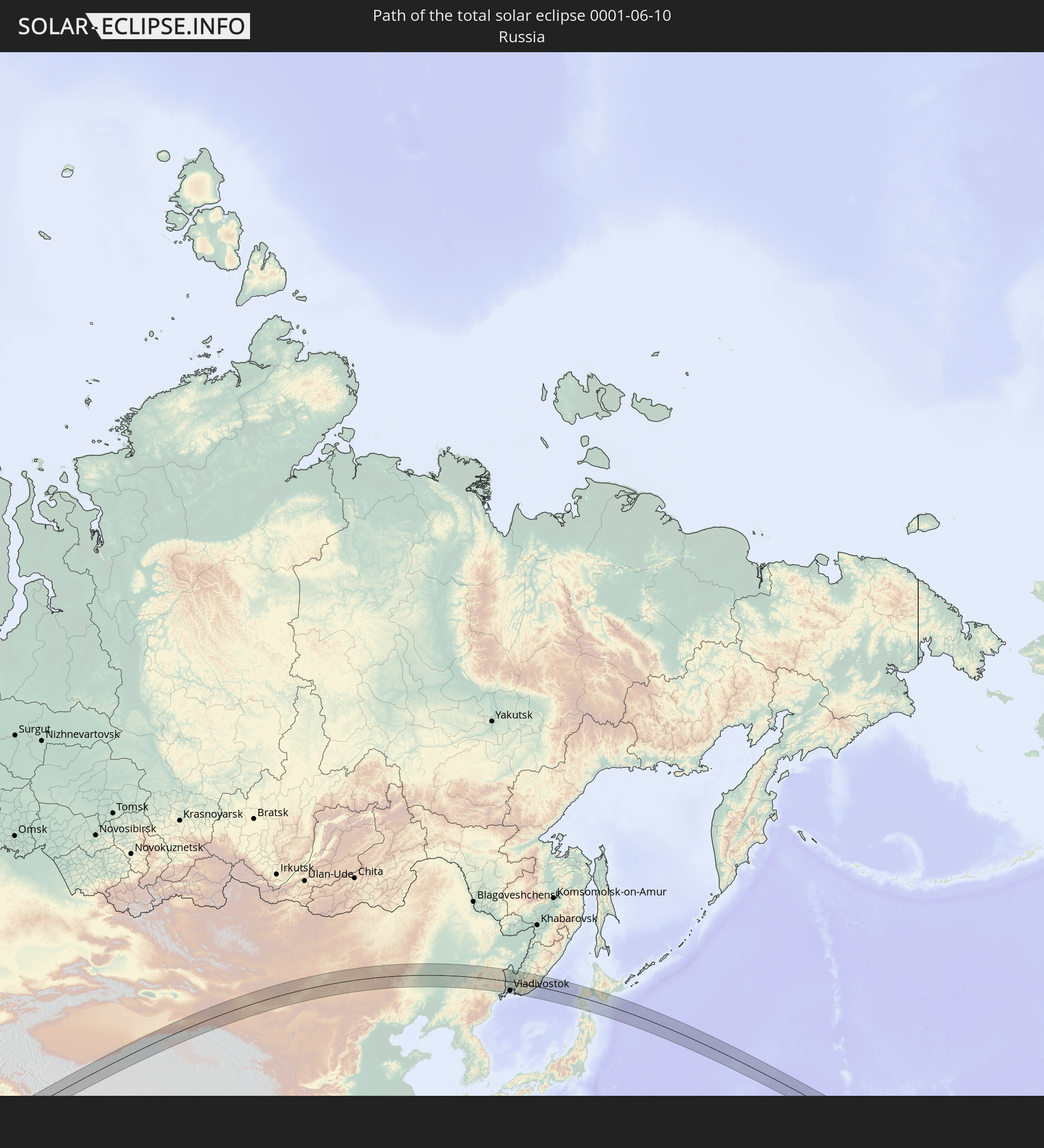 Russland
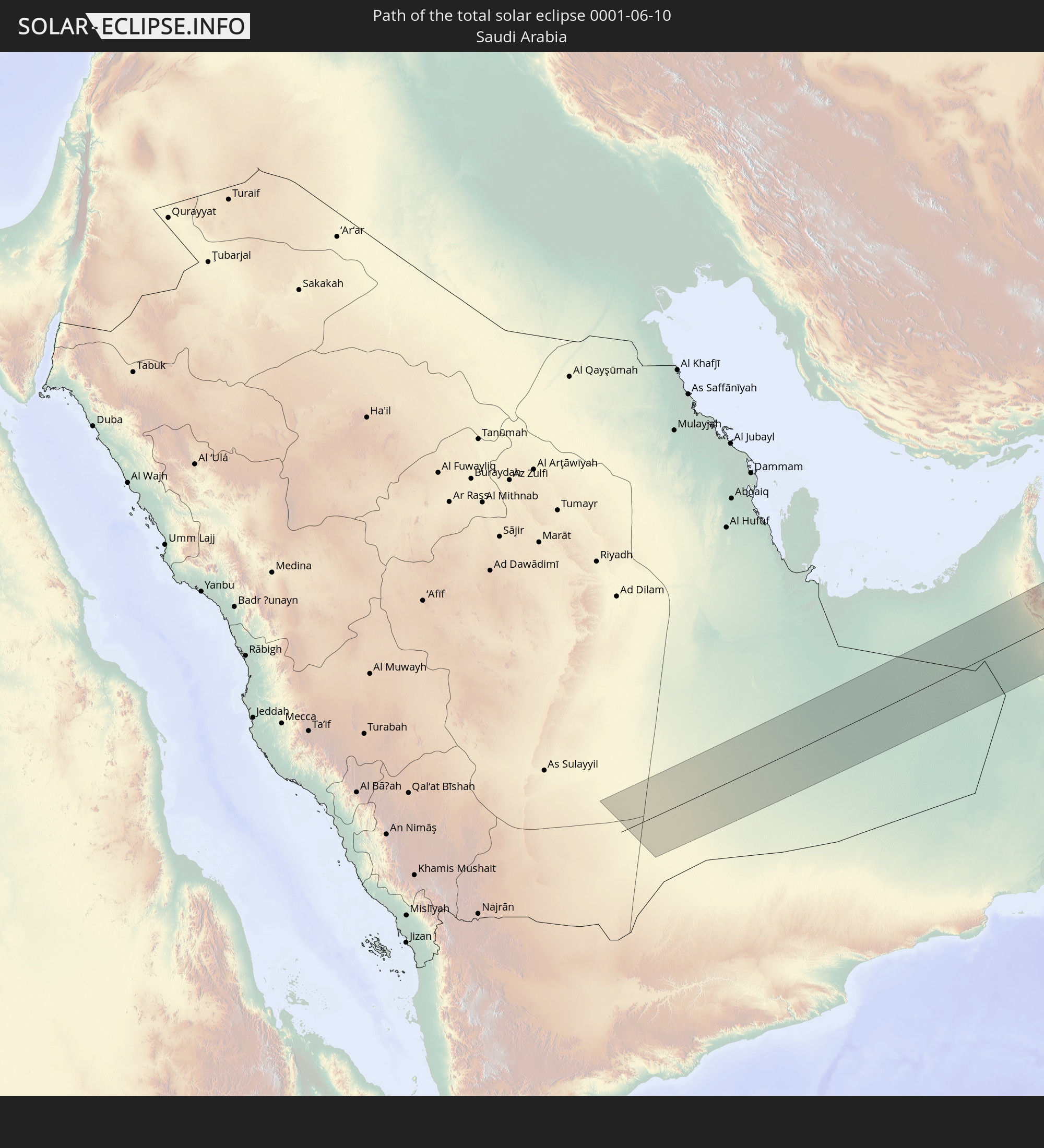 Saudi-Arabien
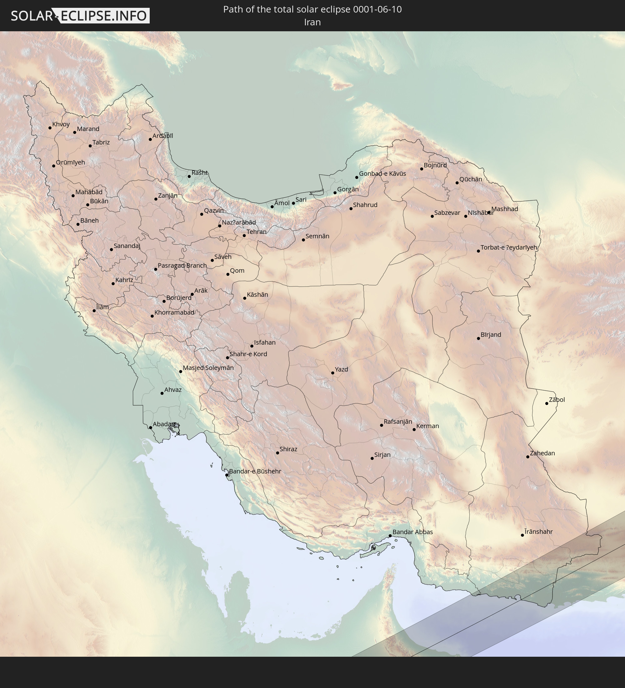 Iran
Iran
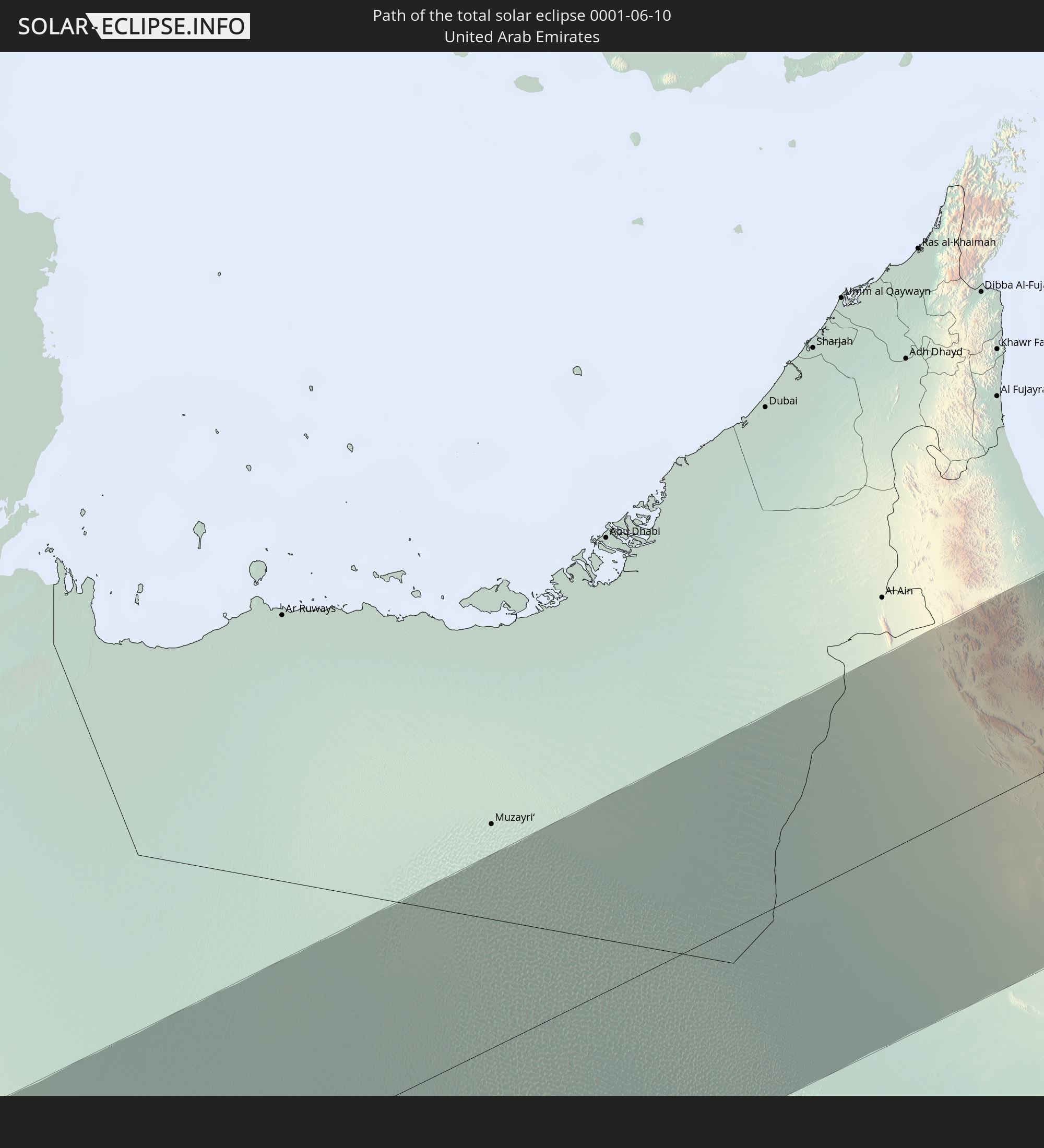 Vereinigte Arabische Emirate
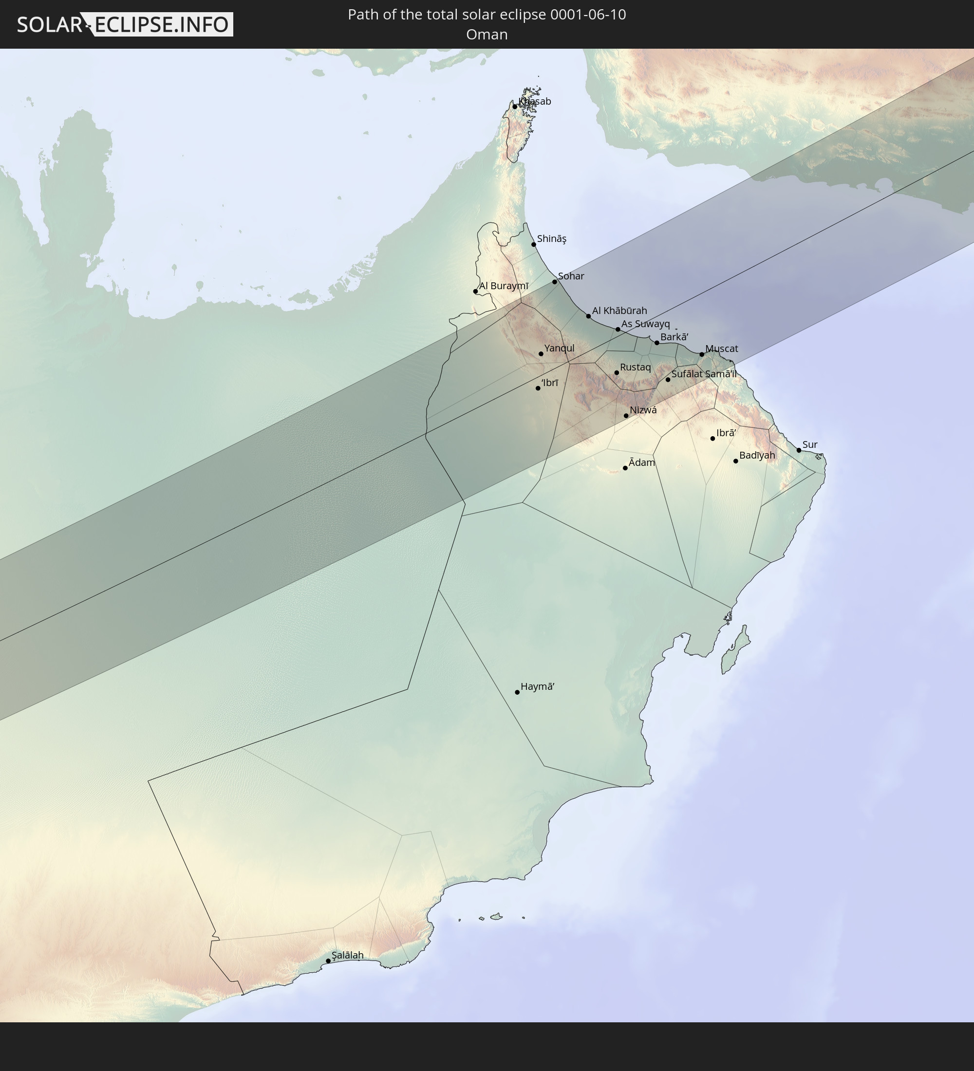 Oman
Oman
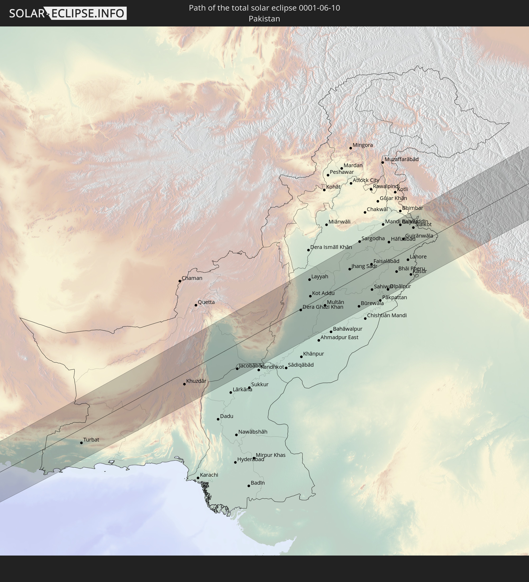 Pakistan
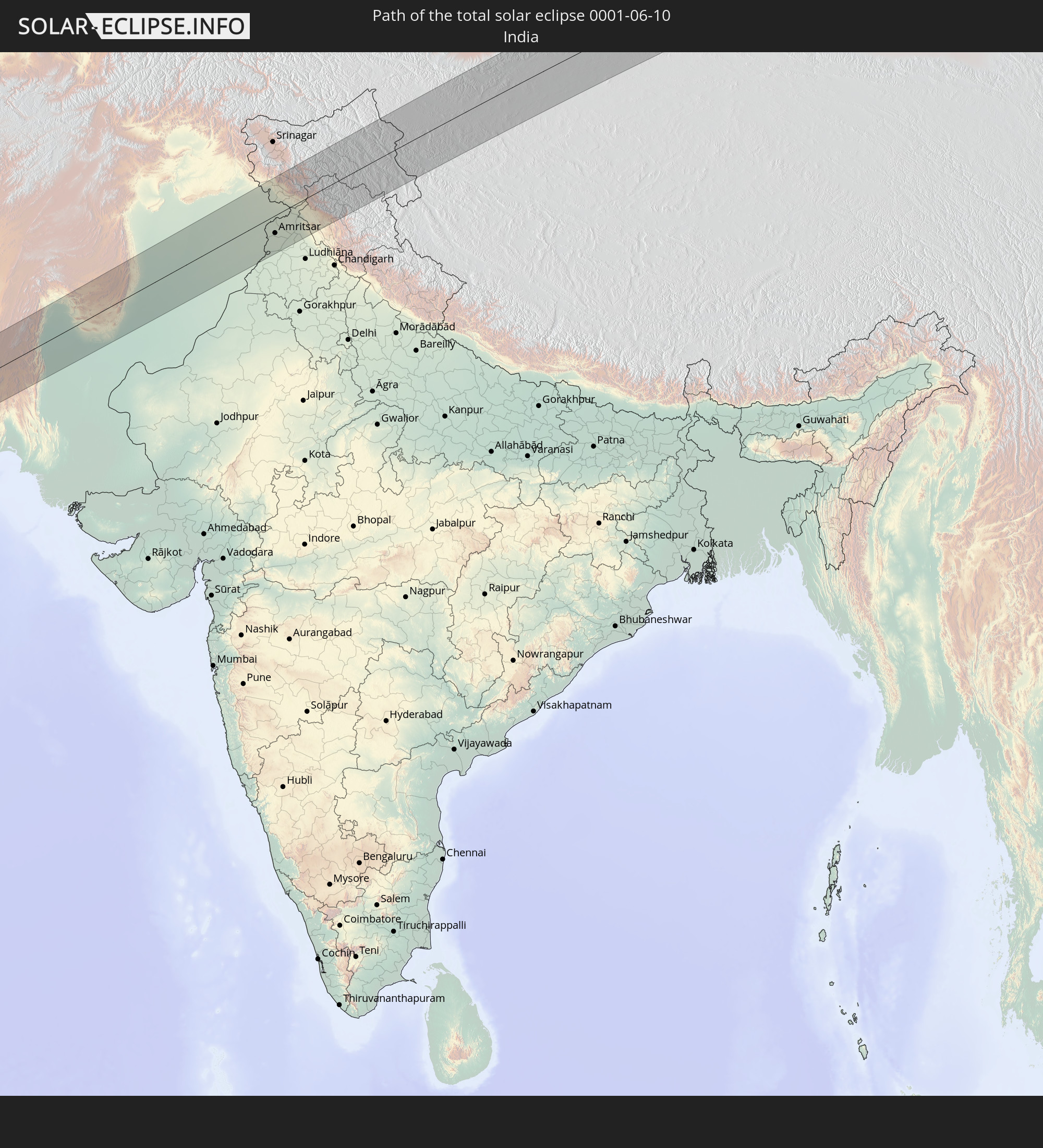 Indien
 Volksrepublik China
 Mongolei
 Japan
Japan
In den folgenden Ländern ist die Sonnenfinsternis partiell zu sehen
 Russland
 Vereinigte Staaten
 United States Minor Outlying Islands
 Kiribati
 Kanada
 Norwegen
 Deutschland
 Dänemark
 Österreich
 Schweden
 Tschechien
 Polen
Polen
 Ungarn
 Slowakei
 Serbien
 Åland Islands
 Griechenland
 Rumänien
 Finnland
 Litauen
 Lettland
 Estland
 Ukraine
 Bulgarien
 Weißrussland
 Türkei
 Moldawien
 Republik Zypern
 Israel
 Saudi-Arabien
 Jordanien
 Libanon
 Syrien
 Irak
Irak
 Georgien
 Jemen
Jemen
 Armenien
 Iran
Iran
 Aserbaidschan
 Kasachstan
 Kuwait
 Bahrain
 Katar
Katar
 Vereinigte Arabische Emirate
 Oman
Oman
 Turkmenistan
 Usbekistan
 Afghanistan
 Pakistan
 Tadschikistan
 Indien
 Kirgisistan
 Britisches Territorium im Indischen Ozean
 Malediven
 Volksrepublik China
 Sri Lanka
 Nepal
Nepal
 Mongolei
 Bangladesch
 Bhutan
 Myanmar
 Indonesien
 Thailand
 Laos
Laos
 Vietnam
 Kambodscha
 Macau
Macau
 Hongkong
 Taiwan
 Philippinen
 Japan
Japan
 Nordkorea
 Südkorea
 Föderierte Staaten von Mikronesien
 Guam
Guam
 Nördliche Marianen
 Marshallinseln
 Nauru
Nauru
 Tuvalu
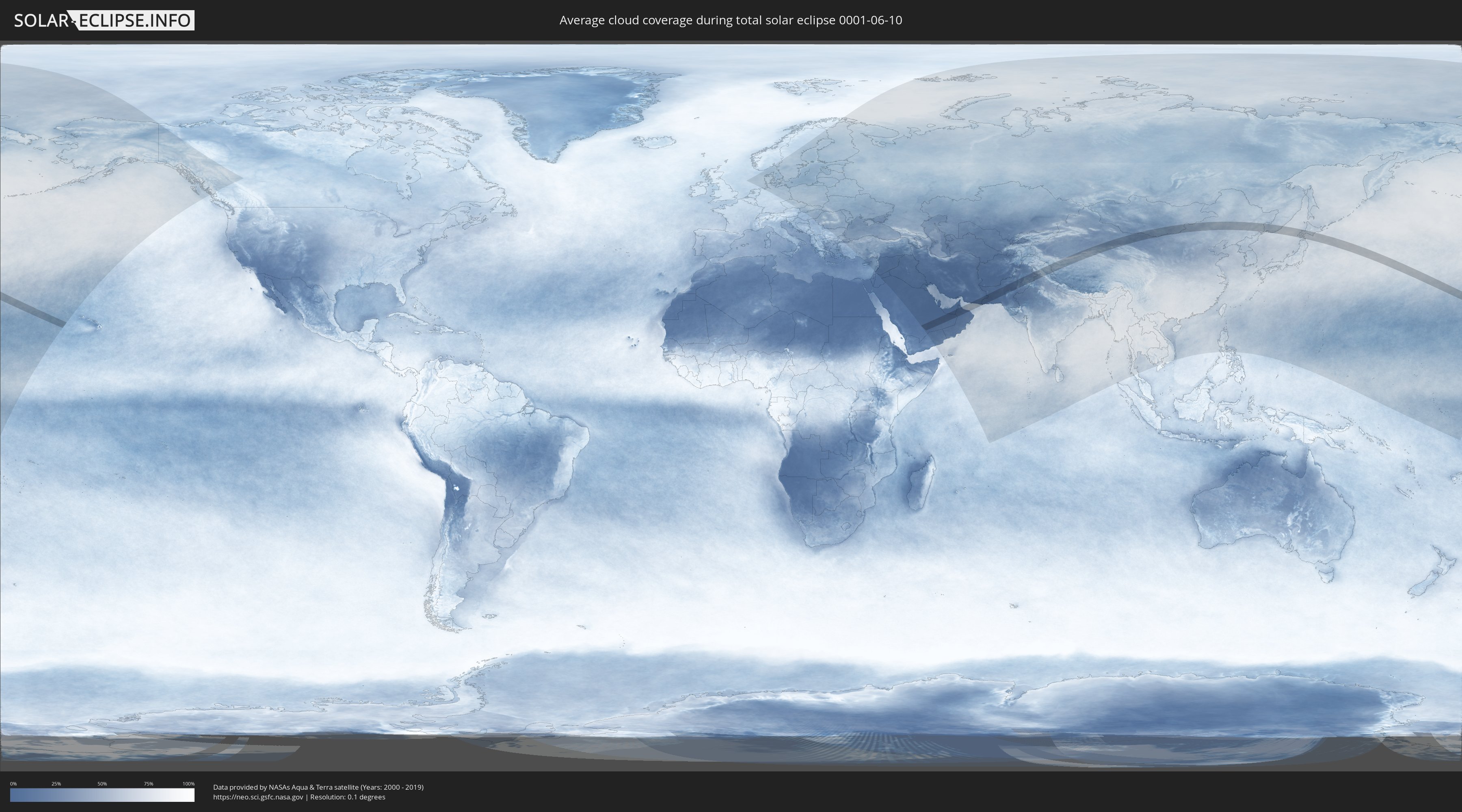
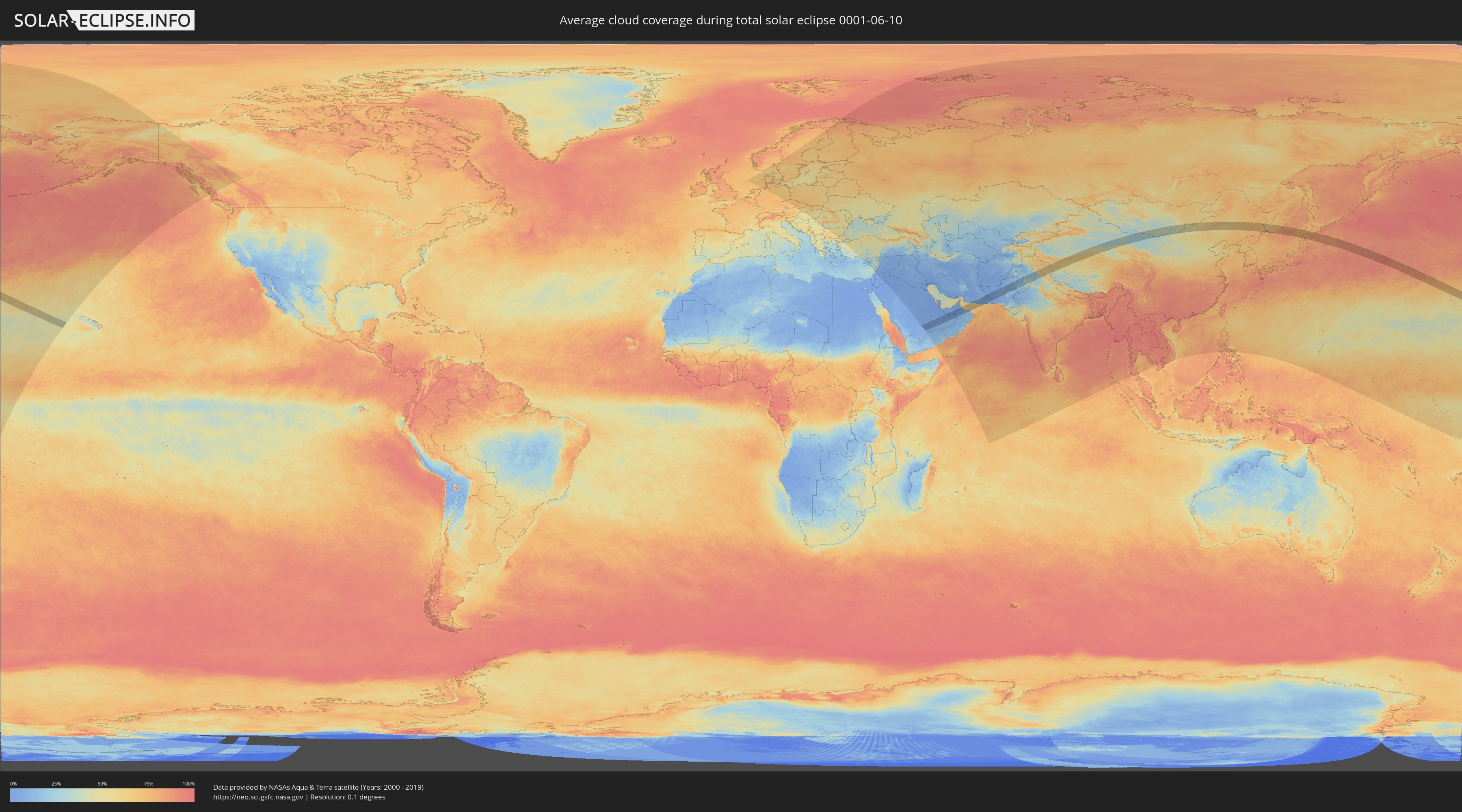
Wie wird das Wetter während der totalen Sonnenfinsternis am 10.06.0001?
Wo ist der beste Ort, um die totale Sonnenfinsternis vom 10.06.0001 zu beobachten?
Die folgenden Karten zeigen die durchschnittliche Bewölkung für den Tag, an dem die totale Sonnenfinsternis
stattfindet. Mit Hilfe der Karten lässt sich der Ort entlang des Finsternispfades eingrenzen,
der die besten Aussichen auf einen klaren wolkenfreien Himmel bietet.
Trotzdem muss man immer lokale Gegenenheiten beachten und sollte sich genau über das Wetter an seinem
gewählten Beobachtungsort informieren.
Die Daten stammen von den beiden NASA-Satelliten
AQUA und TERRA
und wurden über einen Zeitraum von 19 Jahren (2000 - 2019) gemittelt.
Detaillierte Länderkarten
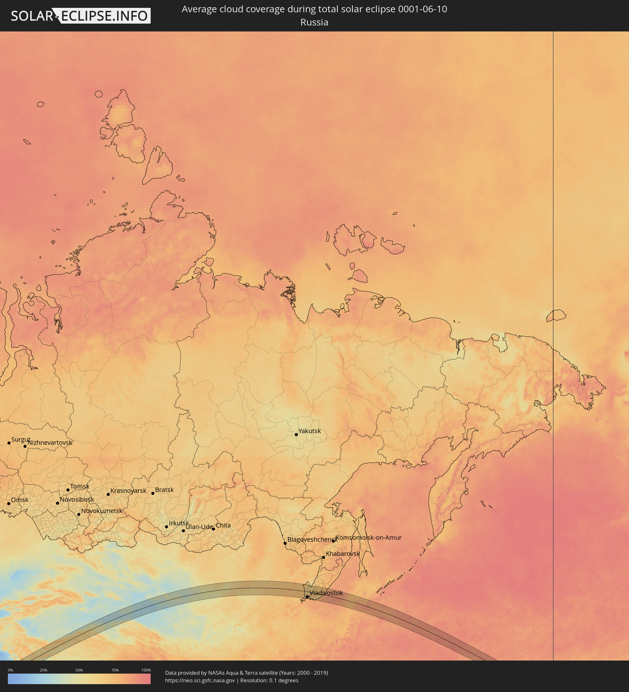 Russland
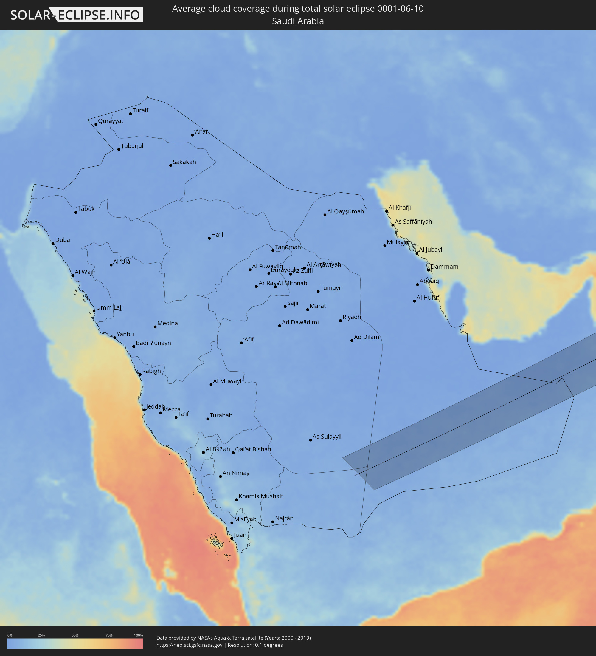 Saudi-Arabien
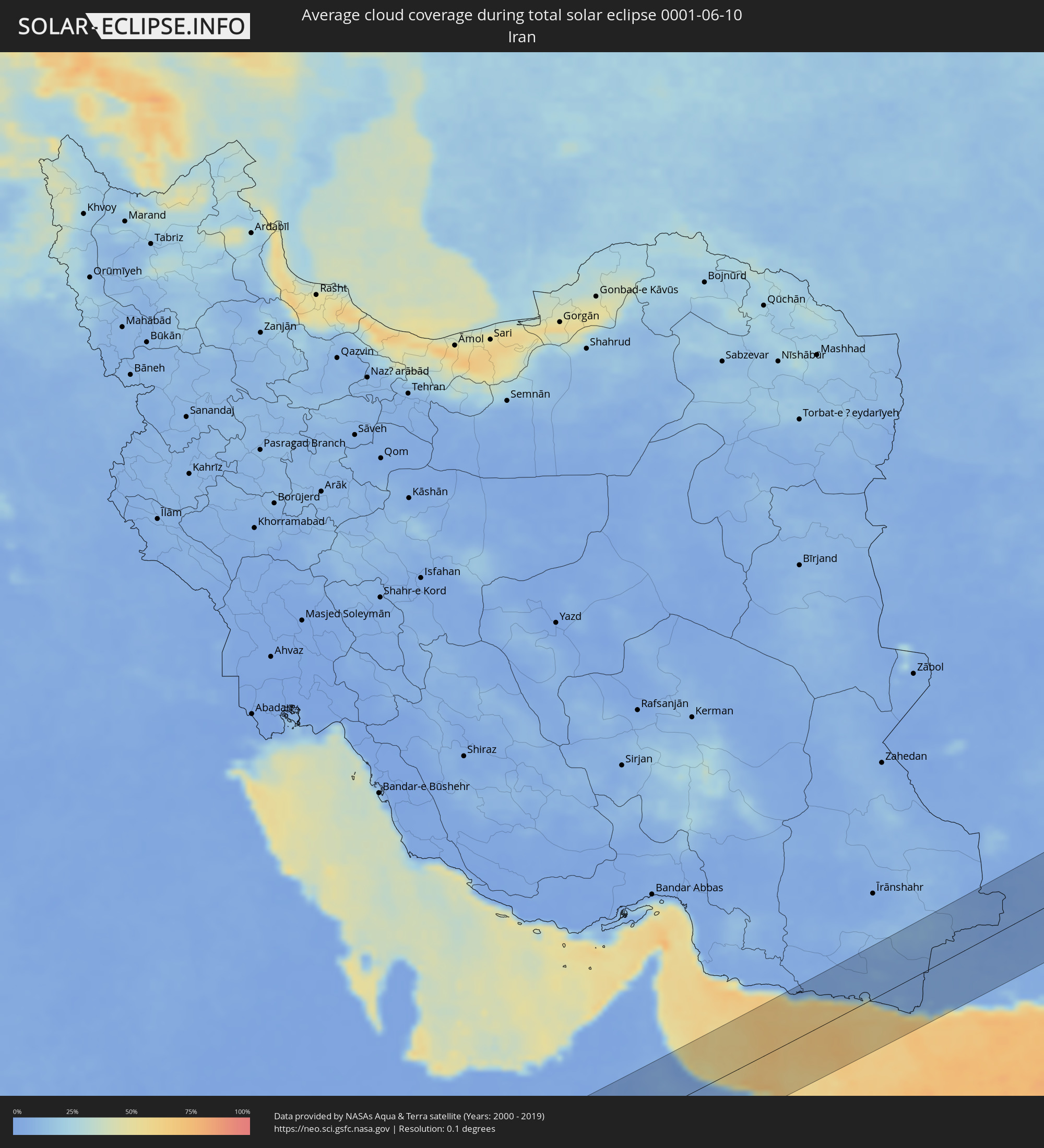 Iran
Iran
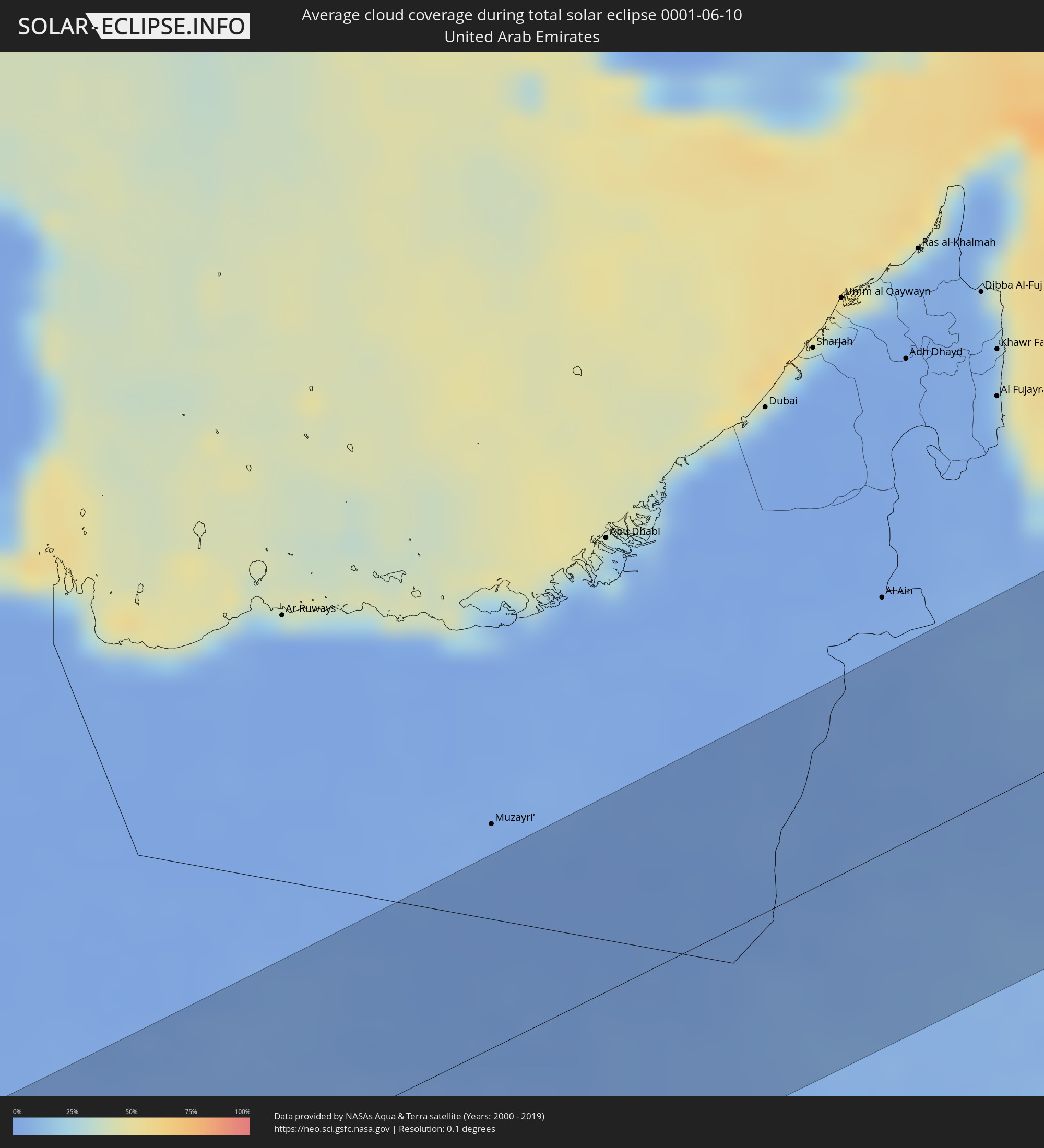 Vereinigte Arabische Emirate
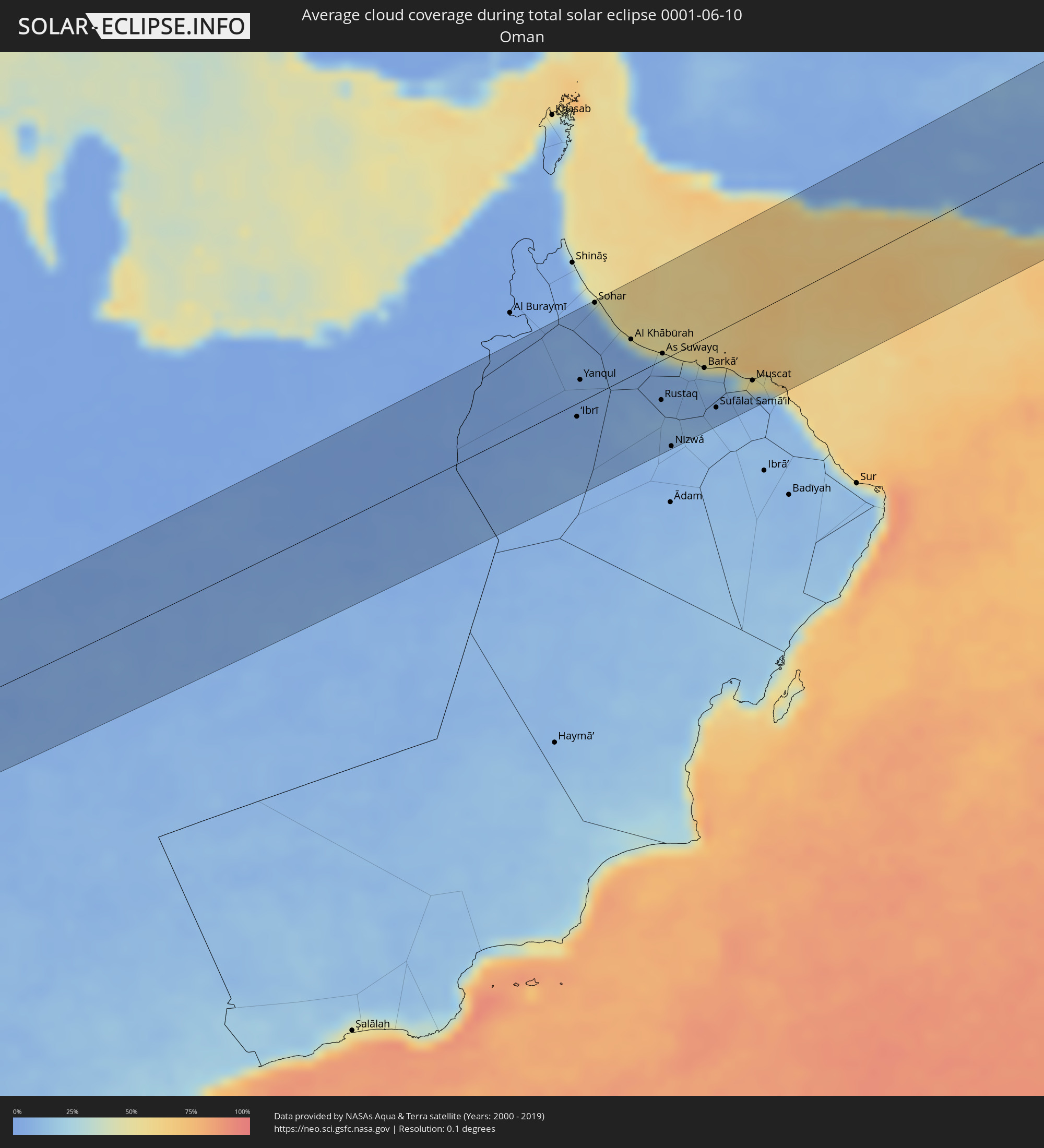 Oman
Oman
 Pakistan
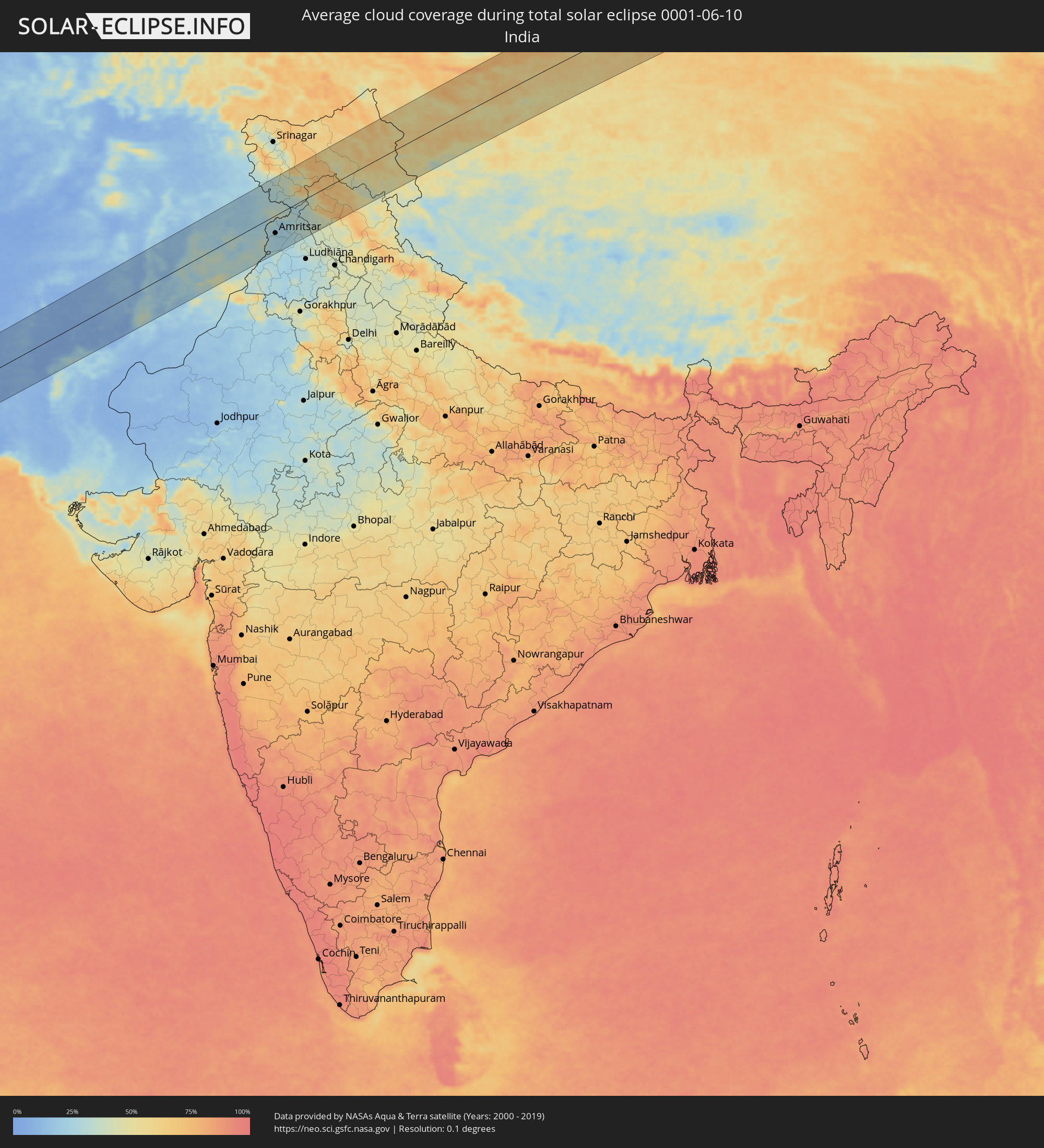 Indien
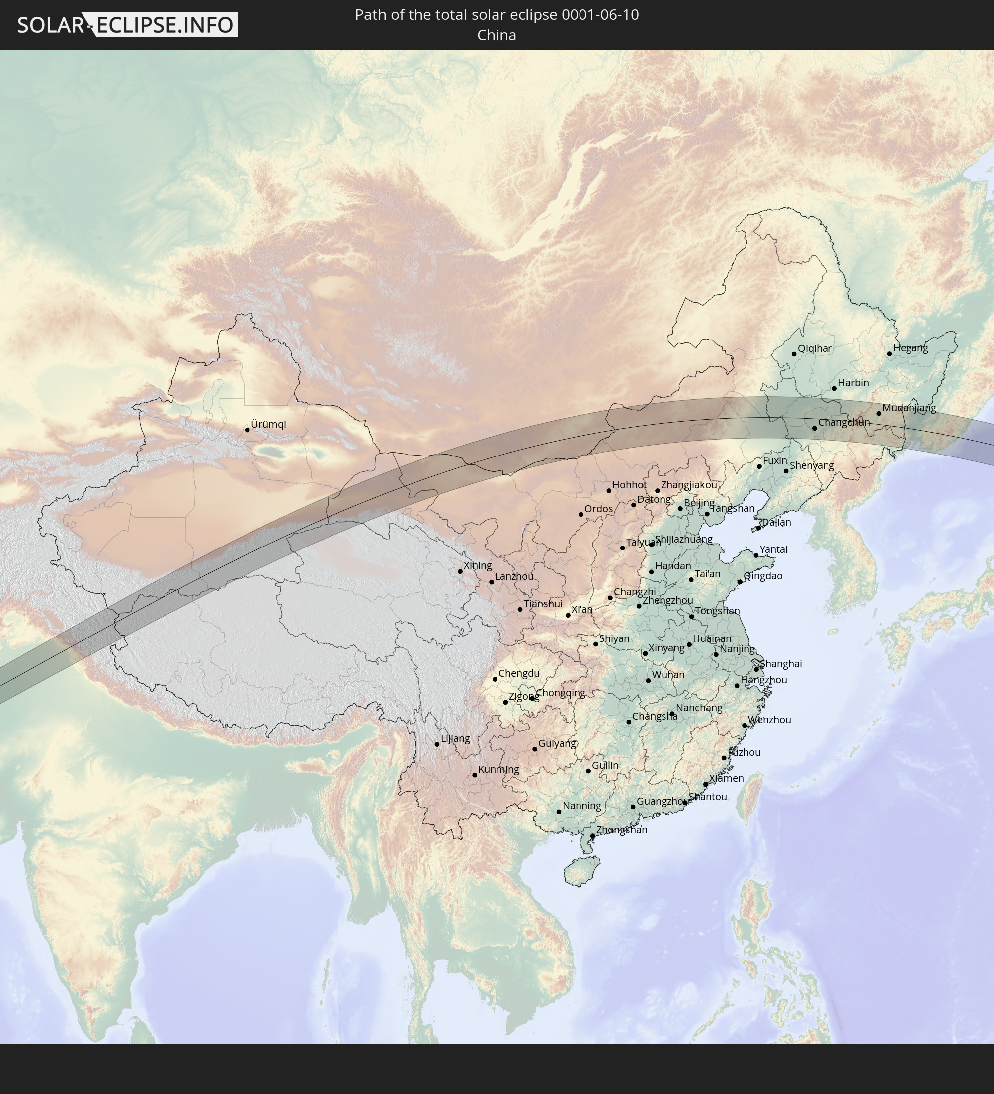
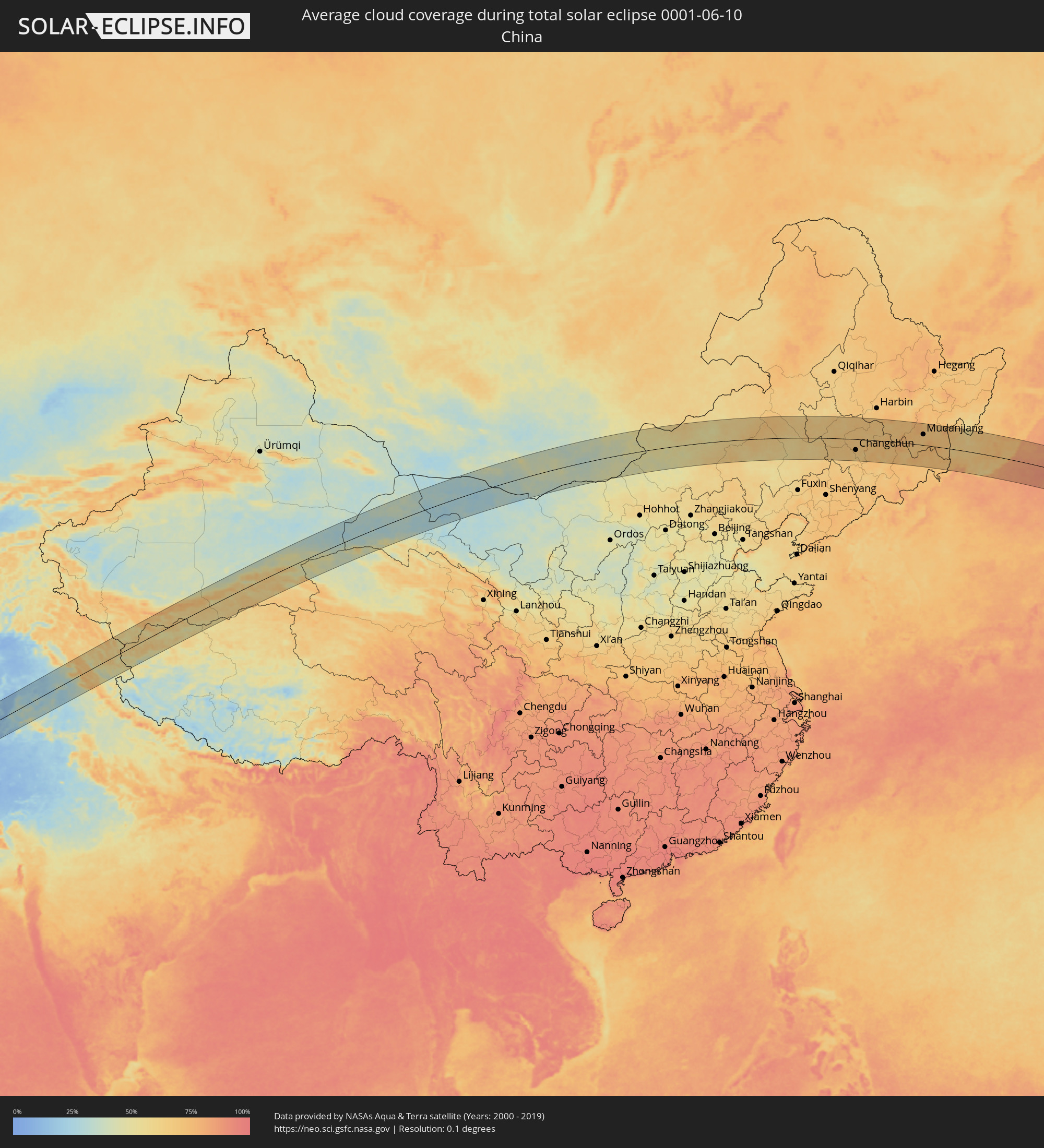 Volksrepublik China
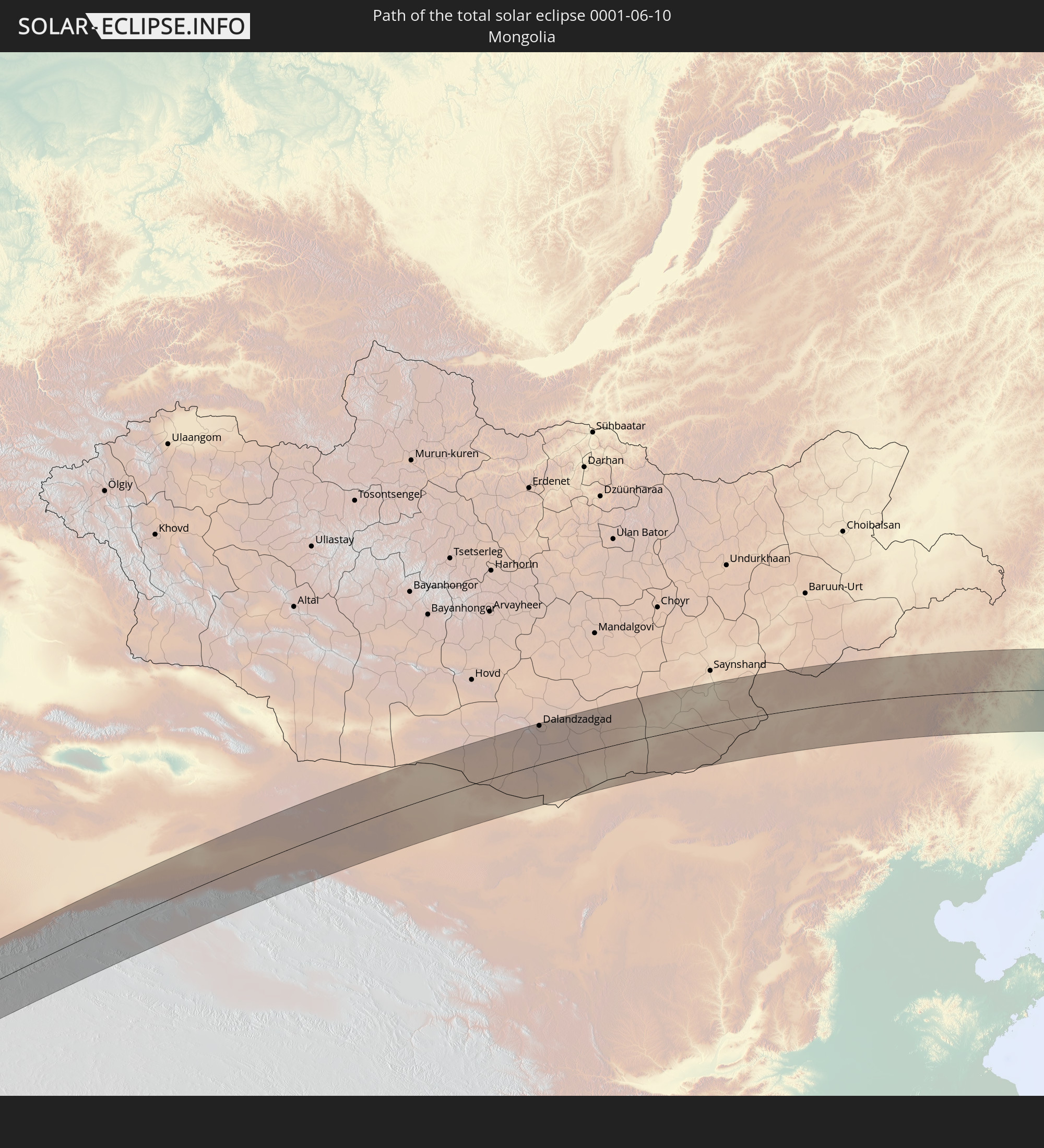
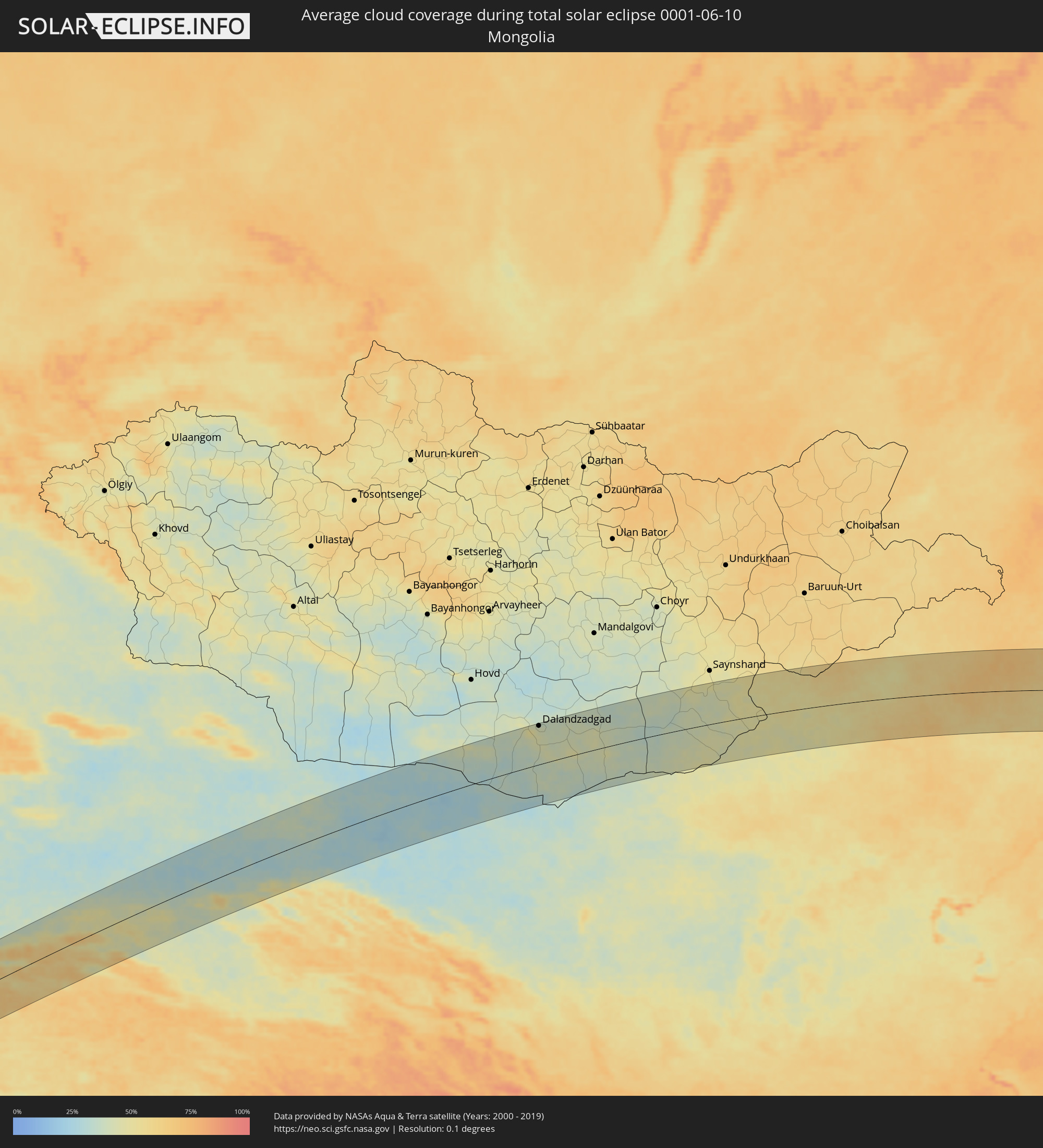 Mongolei
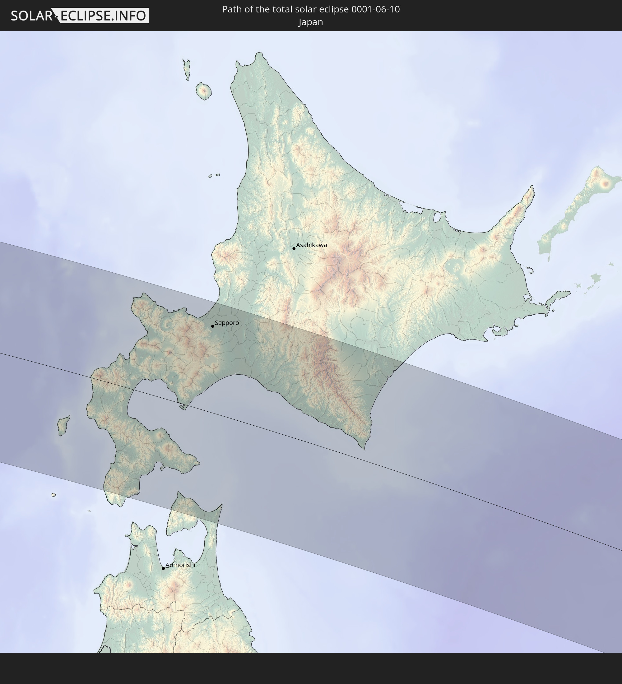
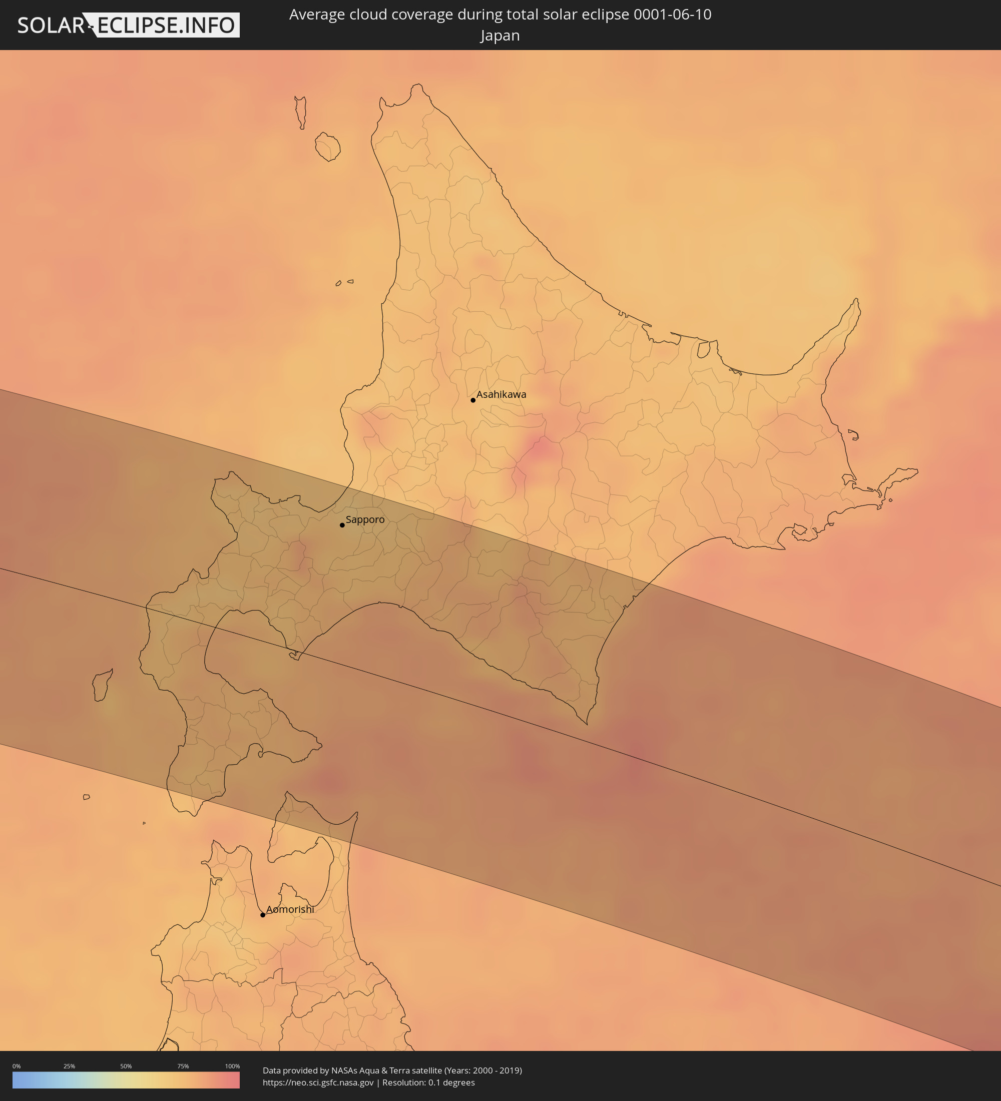 Japan
Japan
Orte im Finsternispfad
Die nachfolgene Tabelle zeigt Städte und Orte mit mehr als 5.000 Einwohnern, die sich im Finsternispfad befinden. Städte mit mehr als 100.000 Einwohnern sind dick gekennzeichnet. Mit einem Klick auf den Ort öffnet sich eine Detailkarte die die Lage des jeweiligen Ortes zusammen mit dem Verlauf der zentralen Finsternis präsentiert.
| Ort | Typ | Dauer der Verfinsterung | Ortszeit bei maximaler Verfinsterung | Entfernung zur Zentrallinie | Ø Bewölkung |
|
‘Ibrī, Az̧ Z̧āhirah
|
total | - | 05:54:13 UTC+03:41 | 13 km | 4% |
|
Yanqul, Az̧ Z̧āhirah
|
total | - | 05:54:34 UTC+03:41 | 22 km | 5% |
|
Sohar, Al Batinah North Governorate
|
total | - | 05:55:19 UTC+03:41 | 90 km | 12% |
|
Şaḩam, Al Batinah North Governorate
|
total | - | 05:55:07 UTC+03:41 | 64 km | 26% |
|
Al Khābūrah, Al Batinah North Governorate
|
total | - | 05:54:56 UTC+03:41 | 36 km | 16% |
|
Bahlā’, Muḩāfaz̧at ad Dākhilīyah
|
total | - | 05:53:56 UTC+03:41 | 74 km | 8% |
|
Rustaq, Al Batinah South Governorate
|
total | - | 05:54:19 UTC+03:41 | 39 km | 9% |
|
As Suwayq, Al Batinah North Governorate
|
total | - | 05:54:46 UTC+03:41 | 6 km | 6% |
|
Bayt al ‘Awābī, Al Batinah South Governorate
|
total | - | 05:54:14 UTC+03:41 | 52 km | 10% |
|
Nizwá, Muḩāfaz̧at ad Dākhilīyah
|
total | - | 05:53:52 UTC+03:41 | 89 km | 7% |
|
Barkā’, Al Batinah South Governorate
|
total | - | 05:54:37 UTC+03:41 | 29 km | 13% |
|
Sufālat Samā’il, Muḩāfaz̧at ad Dākhilīyah
|
total | - | 05:54:14 UTC+03:41 | 74 km | 9% |
|
Bidbid, Muḩāfaz̧at ad Dākhilīyah
|
total | - | 05:54:19 UTC+03:41 | 70 km | 7% |
|
Seeb, Muḩāfaz̧at Masqaţ
|
total | - | 05:54:34 UTC+03:41 | 47 km | 25% |
|
Bawshar, Muḩāfaz̧at Masqaţ
|
total | - | 05:54:27 UTC+03:41 | 68 km | 12% |
|
Muscat, Muḩāfaz̧at Masqaţ
|
total | - | 05:54:29 UTC+03:41 | 65 km | 12% |
|
Chabahar, Sistan and Baluchestan
|
total | - | 05:40:48 UTC+03:25 | 1 km | 58% |
|
Qaşr-e Qand, Sistan and Baluchestan
|
total | - | 05:41:49 UTC+03:25 | 88 km | 7% |
|
Khuzdār, Balochistān
|
total | - | 06:47:01 UTC+04:28 | 35 km | 8% |
|
Jacobābād, Sindh
|
total | - | 06:48:06 UTC+04:28 | 75 km | 20% |
|
Dera Ghazi Khan, Punjab
|
total | - | 06:51:06 UTC+04:28 | 4 km | 15% |
|
Muzaffargarh, Punjab
|
total | - | 06:51:22 UTC+04:28 | 28 km | 20% |
|
Multān, Punjab
|
total | - | 06:51:39 UTC+04:28 | 30 km | 21% |
|
Jhang Sadr, Punjab
|
total | - | 06:53:26 UTC+04:28 | 35 km | 33% |
|
Būrewāla, Punjab
|
total | - | 06:52:10 UTC+04:28 | 87 km | 30% |
|
Sargodha, Punjab
|
total | - | 06:54:40 UTC+04:28 | 99 km | 17% |
|
Gojra, Punjab
|
total | - | 06:53:27 UTC+04:28 | 7 km | 33% |
|
Chiniot, Punjab
|
total | - | 06:54:20 UTC+04:28 | 49 km | 25% |
|
Faisalābād, Punjab
|
total | - | 06:54:00 UTC+04:28 | 15 km | 23% |
|
Sahiwal, Punjab
|
total | - | 06:53:02 UTC+04:28 | 59 km | 32% |
|
Bahāwalnagar, Punjab
|
total | - | 06:53:02 UTC+04:28 | 84 km | 34% |
|
Okāra, Punjab
|
total | - | 06:53:24 UTC+04:28 | 61 km | 32% |
|
Shahkot, Punjab
|
total | - | 06:54:25 UTC+04:28 | 11 km | 30% |
|
Hāfizābād, Punjab
|
total | - | 06:55:10 UTC+04:28 | 50 km | 22% |
|
Sheikhupura, Punjab
|
total | - | 06:54:52 UTC+04:28 | 2 km | 26% |
|
Gujrāt, Punjab
|
total | - | 06:56:04 UTC+04:28 | 82 km | 22% |
|
Gujrānwāla, Punjab
|
total | - | 06:55:34 UTC+04:28 | 37 km | 25% |
|
Kamoke, Punjab
|
total | - | 06:55:21 UTC+04:28 | 17 km | 23% |
|
Murīdke, Punjab
|
total | - | 06:55:08 UTC+04:28 | 2 km | 25% |
|
Lahore, Punjab
|
total | - | 06:54:51 UTC+04:28 | 30 km | 29% |
|
Daska, Punjab
|
total | - | 06:55:53 UTC+04:28 | 45 km | 26% |
|
Kasūr, Punjab
|
total | - | 06:54:21 UTC+04:28 | 77 km | 31% |
|
Sialkot, Punjab
|
total | - | 06:56:13 UTC+04:28 | 53 km | 27% |
|
Ajnāla, Punjab
|
total | - | 07:48:27 UTC+05:21 | 21 km | 24% |
|
Patti, Punjab
|
total | - | 07:47:46 UTC+05:21 | 80 km | 25% |
|
Jammu, Kashmir
|
total | - | 07:49:42 UTC+05:21 | 61 km | 29% |
|
Amritsar, Punjab
|
total | - | 07:48:13 UTC+05:21 | 47 km | 23% |
|
Tarn Tāran, Punjab
|
total | - | 07:48:02 UTC+05:21 | 66 km | 23% |
|
Fatehgarh Chūriān, Punjab
|
total | - | 07:48:35 UTC+05:21 | 27 km | 24% |
|
Sāmba, Kashmir
|
total | - | 07:49:37 UTC+05:21 | 33 km | 31% |
|
Udhampur, Kashmir
|
total | - | 07:50:07 UTC+05:21 | 68 km | 33% |
|
Batāla, Punjab
|
total | - | 07:48:40 UTC+05:21 | 44 km | 25% |
|
Dhāriwāl, Punjab
|
total | - | 07:48:56 UTC+05:21 | 35 km | 25% |
|
Qādiān, Punjab
|
total | - | 07:48:47 UTC+05:21 | 51 km | 27% |
|
Kapūrthala, Punjab
|
total | - | 07:48:12 UTC+05:21 | 94 km | 27% |
|
Dīnānagar, Punjab
|
total | - | 07:49:16 UTC+05:21 | 24 km | 30% |
|
Kathua, Kashmir
|
total | - | 07:49:36 UTC+05:21 | 4 km | 27% |
|
Doda, Kashmir
|
total | - | 07:50:40 UTC+05:21 | 71 km | 44% |
|
Mukeriān, Punjab
|
total | - | 07:49:06 UTC+05:21 | 49 km | 30% |
|
Bhogpur, Punjab
|
total | - | 07:48:36 UTC+05:21 | 89 km | 28% |
|
Pathānkot, Punjab
|
total | - | 07:49:33 UTC+05:21 | 19 km | 30% |
|
Dasūya, Punjab
|
total | - | 07:48:57 UTC+05:21 | 64 km | 32% |
|
Kishtwār, Kashmir
|
total | - | 07:51:02 UTC+05:21 | 77 km | 49% |
|
Talwāra, Punjab
|
total | - | 07:49:15 UTC+05:21 | 63 km | 34% |
|
Chamba, Himachal Pradesh
|
total | - | 07:50:14 UTC+05:21 | 13 km | 42% |
|
Dharmsāla, Himachal Pradesh
|
total | - | 07:49:54 UTC+05:21 | 55 km | 43% |
|
Padam, Kashmir
|
total | - | 07:51:58 UTC+05:21 | 42 km | 41% |
|
Leh, Kashmir
|
total | - | 07:53:24 UTC+05:21 | 79 km | 54% |
|
Dalandzadgad, Ömnögovĭ
|
total | - | 10:25:03 UTC+07:07 | 101 km | 41% |
|
Xilin Hot, Inner Mongolia
|
total | - | 11:38:55 UTC+08:00 | 28 km | 57% |
|
Tongliao, Inner Mongolia
|
total | - | 11:51:07 UTC+08:00 | 91 km | 59% |
|
Guangming, Jilin
|
total | - | 11:52:02 UTC+08:00 | 101 km | 61% |
|
Kaitong, Jilin
|
total | - | 11:52:46 UTC+08:00 | 43 km | 63% |
|
Zhengjiatun, Jilin
|
total | - | 11:53:36 UTC+08:00 | 101 km | 67% |
|
Fuyu, Jilin
|
total | - | 11:55:53 UTC+08:00 | 89 km | 67% |
|
Gongzhuling, Jilin
|
total | - | 11:56:12 UTC+08:00 | 98 km | 67% |
|
Qianguo, Jilin
|
total | - | 11:55:58 UTC+08:00 | 82 km | 66% |
|
Changchun, Jilin
|
total | - | 11:57:07 UTC+08:00 | 54 km | 68% |
|
Shuangyang, Jilin
|
total | - | 11:57:53 UTC+08:00 | 92 km | 67% |
|
Dehui, Jilin
|
total | - | 11:57:42 UTC+08:00 | 20 km | 69% |
|
Jiutai, Jilin
|
total | - | 11:58:03 UTC+08:00 | 22 km | 69% |
|
Yushu, Jilin
|
total | - | 11:59:13 UTC+08:00 | 54 km | 69% |
|
Jilin, Jilin
|
total | - | 11:59:32 UTC+08:00 | 51 km | 72% |
|
Jishu, Jilin
|
total | - | 11:59:52 UTC+08:00 | 2 km | 73% |
|
Shulan, Jilin
|
total | - | 12:00:07 UTC+08:00 | 14 km | 73% |
|
Wuchang, Heilongjiang
|
total | - | 12:00:20 UTC+08:00 | 71 km | 68% |
|
Minzhu, Jilin
|
total | - | 12:01:05 UTC+08:00 | 61 km | 67% |
|
Dunhua, Jilin
|
total | - | 12:02:59 UTC+08:00 | 92 km | 68% |
|
Dashitou, Jilin
|
total | - | 12:03:32 UTC+08:00 | 97 km | 69% |
|
Hailin, Heilongjiang
|
total | - | 12:04:39 UTC+08:00 | 50 km | 69% |
|
Mudanjiang, Heilongjiang
|
total | - | 12:05:02 UTC+08:00 | 54 km | 69% |
|
Chaihe, Heilongjiang
|
total | - | 12:05:06 UTC+08:00 | 74 km | 70% |
|
Wangqing, Jilin
|
total | - | 12:05:57 UTC+08:00 | 84 km | 70% |
|
Bamiantong, Heilongjiang
|
total | - | 12:06:34 UTC+08:00 | 100 km | 66% |
|
Pogranichnyy, Primorskiy
|
total | - | 12:55:55 UTC+08:47 | 53 km | 67% |
|
Pokrovka, Primorskiy
|
total | - | 12:56:39 UTC+08:47 | 6 km | 63% |
|
Tavrichanka, Primorskiy
|
total | - | 12:57:27 UTC+08:47 | 60 km | 75% |
|
Vladivostok, Primorskiy
|
total | - | 12:57:36 UTC+08:47 | 84 km | 79% |
|
Razdol’noye, Primorskiy
|
total | - | 12:57:23 UTC+08:47 | 36 km | 69% |
|
Ussuriysk, Primorskiy
|
total | - | 12:57:19 UTC+08:47 | 6 km | 65% |
|
Mikhaylovka, Primorskiy
|
total | - | 12:57:21 UTC+08:47 | 9 km | 64% |
|
Kamen’-Rybolov, Primorskiy
|
total | - | 12:56:56 UTC+08:47 | 98 km | 65% |
|
Khorol’, Primorskiy
|
total | - | 12:57:11 UTC+08:47 | 64 km | 65% |
|
Uglovoye, Primorskiy
|
total | - | 12:57:52 UTC+08:47 | 57 km | 72% |
|
Novoshakhtinskiy, Primorskiy
|
total | - | 12:57:35 UTC+08:47 | 21 km | 66% |
|
Artëm, Primorskiy
|
total | - | 12:58:02 UTC+08:47 | 52 km | 69% |
|
Yaroslavskiy, Primorskiy
|
total | - | 12:57:36 UTC+08:47 | 39 km | 62% |
|
Dunay, Primorskiy
|
total | - | 12:58:37 UTC+08:47 | 103 km | 80% |
|
Bol’shoy Kamen’, Primorskiy
|
total | - | 12:58:30 UTC+08:47 | 77 km | 69% |
|
Fokino, Primorskiy
|
total | - | 12:58:41 UTC+08:47 | 92 km | 71% |
|
Chernigovka, Primorskiy
|
total | - | 12:58:08 UTC+08:47 | 61 km | 62% |
|
Livadiya, Primorskiy
|
total | - | 12:59:16 UTC+08:47 | 100 km | 77% |
|
Spassk-Dal’niy, Primorskiy
|
total | - | 12:58:25 UTC+08:47 | 92 km | 67% |
|
Nakhodka, Primorskiy
|
total | - | 12:59:40 UTC+08:47 | 103 km | 78% |
|
Partizansk, Primorskiy
|
total | - | 12:59:56 UTC+08:47 | 65 km | 63% |
|
Arsen’yev, Primorskiy
|
total | - | 12:59:32 UTC+08:47 | 50 km | 68% |
|
Chuguyevka, Primorskiy
|
total | - | 13:00:34 UTC+08:47 | 60 km | 70% |
|
Preobrazheniye, Primorskiy
|
total | - | 13:01:32 UTC+08:47 | 78 km | 78% |
|
Kavalerovo, Primorskiy
|
total | - | 13:02:35 UTC+08:47 | 90 km | 70% |
|
Iwanai, Hokkaido
|
total | - | 13:25:27 UTC+09:00 | 55 km | 74% |
|
Kamiiso, Hokkaido
|
total | - | 13:26:51 UTC+09:00 | 65 km | 76% |
|
Nanae, Hokkaido
|
total | - | 13:26:51 UTC+09:00 | 57 km | 76% |
|
Hakodate, Hokkaido
|
total | - | 13:27:03 UTC+09:00 | 68 km | 77% |
|
Yoichi, Hokkaido
|
total | - | 13:25:39 UTC+09:00 | 86 km | 71% |
|
Date, Hokkaido
|
total | - | 13:26:33 UTC+09:00 | 9 km | 75% |
|
Muroran, Hokkaido
|
total | - | 13:26:55 UTC+09:00 | 4 km | 79% |
|
Otaru, Hokkaido
|
total | - | 13:26:02 UTC+09:00 | 90 km | 72% |
|
Mutsu, Aomori
|
total | - | 13:28:21 UTC+09:00 | 108 km | 76% |
|
Sapporo, Hokkaido
|
total | - | 13:26:43 UTC+09:00 | 85 km | 72% |
|
Shiraoi, Hokkaido
|
total | - | 13:27:15 UTC+09:00 | 29 km | 81% |
|
Ishikari, Hokkaido
|
total | - | 13:26:33 UTC+09:00 | 103 km | 68% |
|
Tōbetsu, Hokkaido
|
total | - | 13:26:50 UTC+09:00 | 105 km | 69% |
|
Ebetsu, Hokkaido
|
total | - | 13:27:00 UTC+09:00 | 94 km | 72% |
|
Kitahiroshima, Hokkaido
|
total | - | 13:27:10 UTC+09:00 | 80 km | 74% |
|
Tomakomai, Hokkaido
|
total | - | 13:27:34 UTC+09:00 | 45 km | 84% |
|
Chitose, Hokkaido
|
total | - | 13:27:27 UTC+09:00 | 65 km | 76% |
|
Iwamizawa, Hokkaido
|
total | - | 13:27:14 UTC+09:00 | 108 km | 71% |
|
Shizunai-furukawachō, Hokkaido
|
total | - | 13:29:07 UTC+09:00 | 31 km | 84% |