Totale Sonnenfinsternis vom 20.09.0461
| Wochentag: | Dienstag |
| Maximale Dauer der Verfinsterung: | 03m09s |
| Maximale Breite des Finsternispfades: | 123 km |
| Saroszyklus: | 90 |
| Bedeckungsgrad: | 100% |
| Magnitude: | 1.0364 |
| Gamma: | -0.0755 |
Wo kann man die Sonnenfinsternis vom 20.09.0461 sehen?
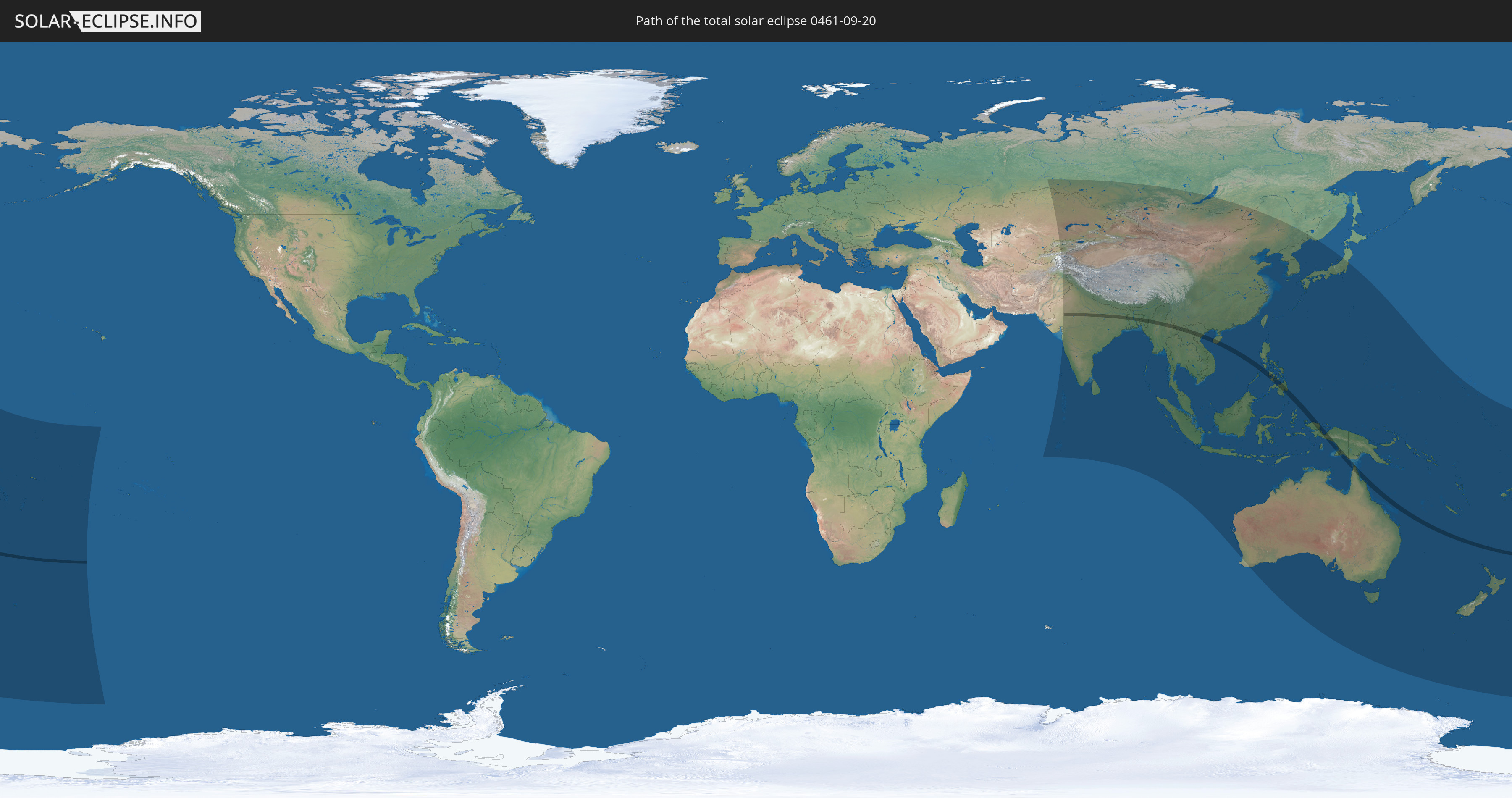
Die Sonnenfinsternis am 20.09.0461 kann man in 59 Ländern als partielle Sonnenfinsternis beobachten.
Der Finsternispfad verläuft durch 10 Länder. Nur in diesen Ländern ist sie als totale Sonnenfinsternis zu sehen.
In den folgenden Ländern ist die Sonnenfinsternis total zu sehen
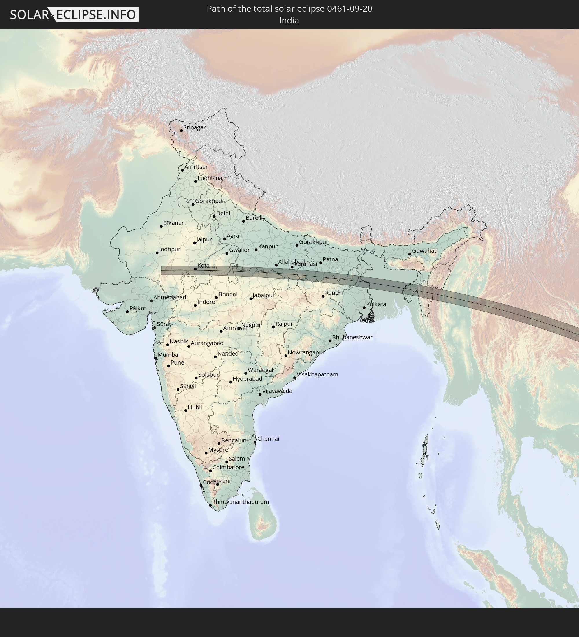 Indien
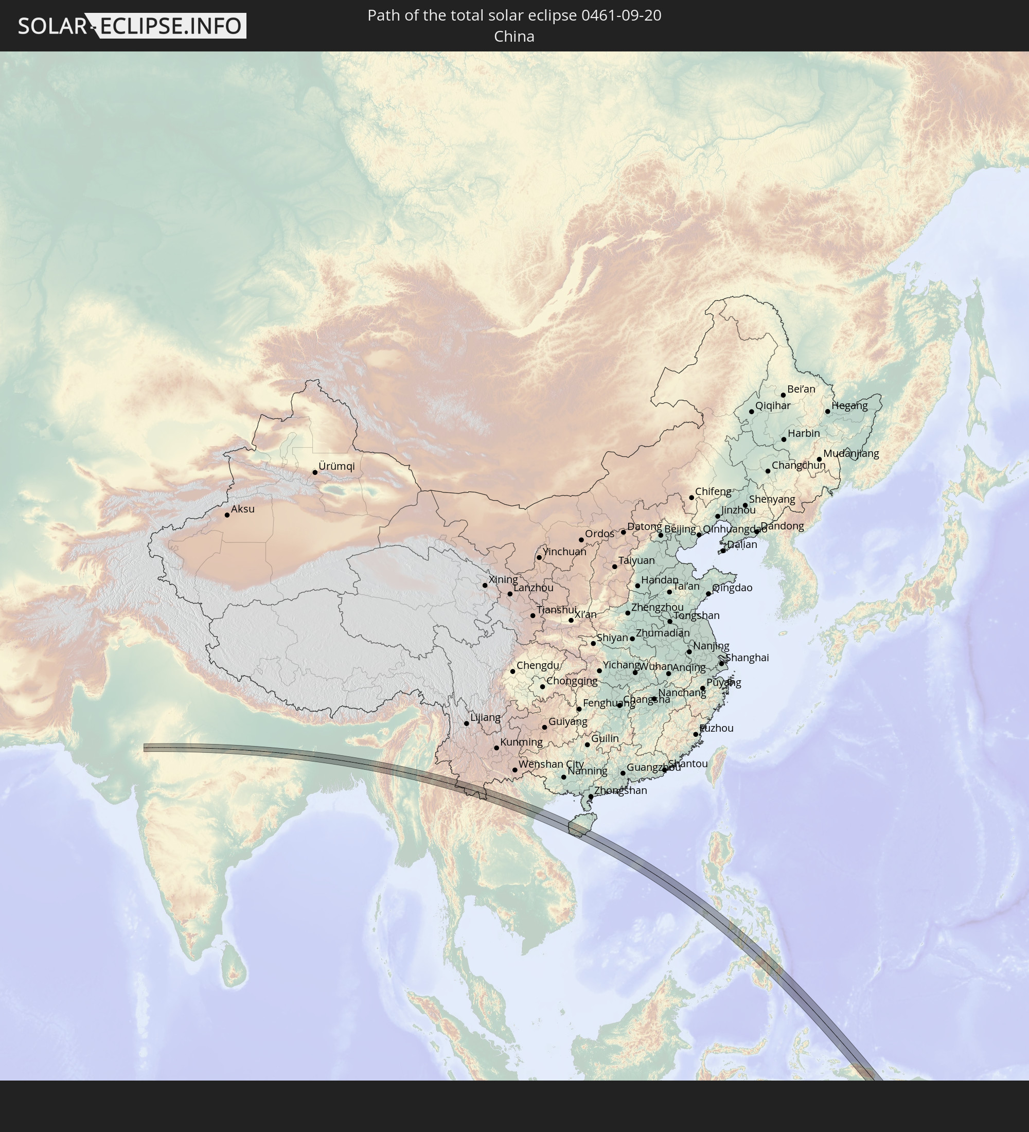 Volksrepublik China
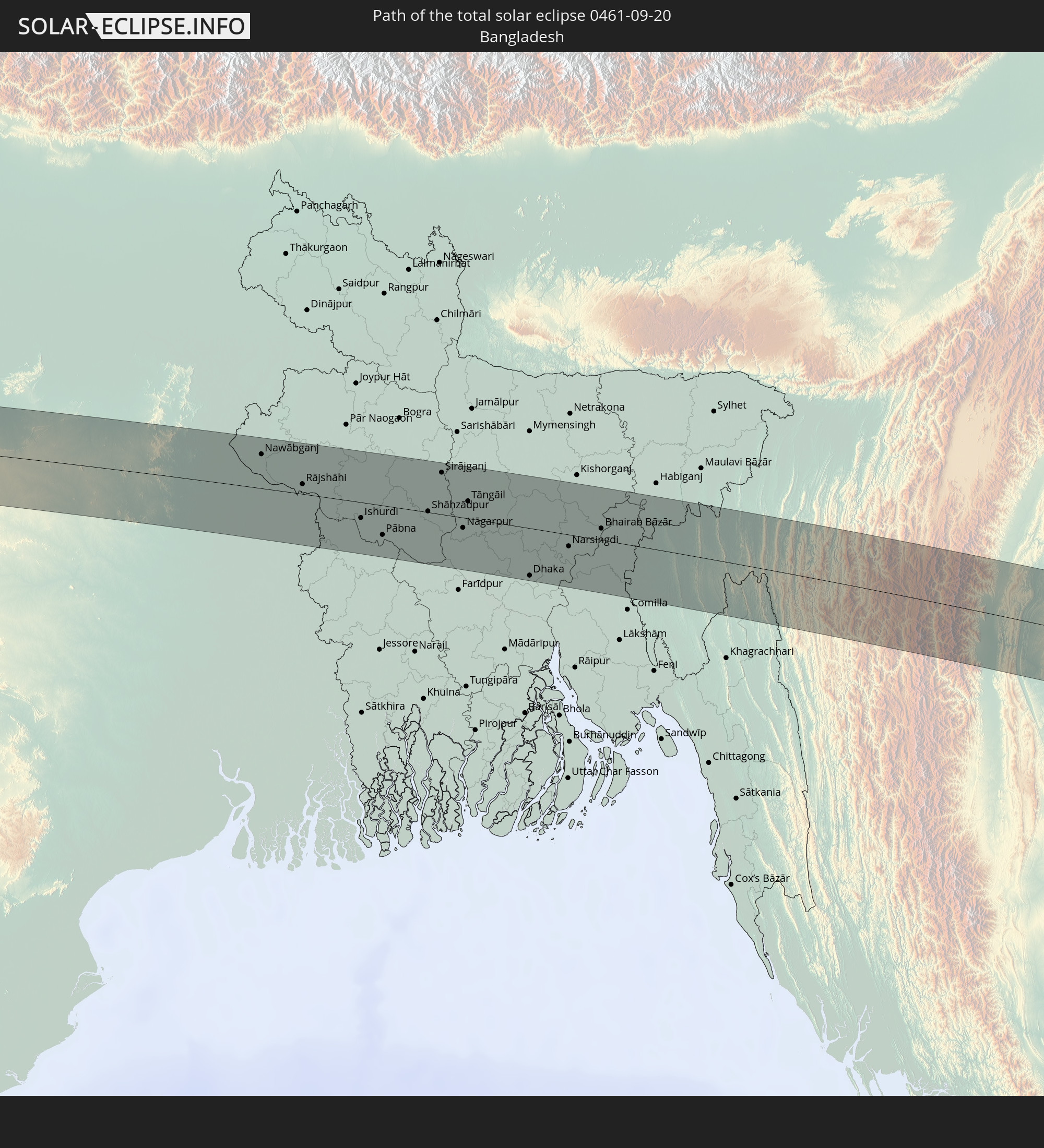 Bangladesch
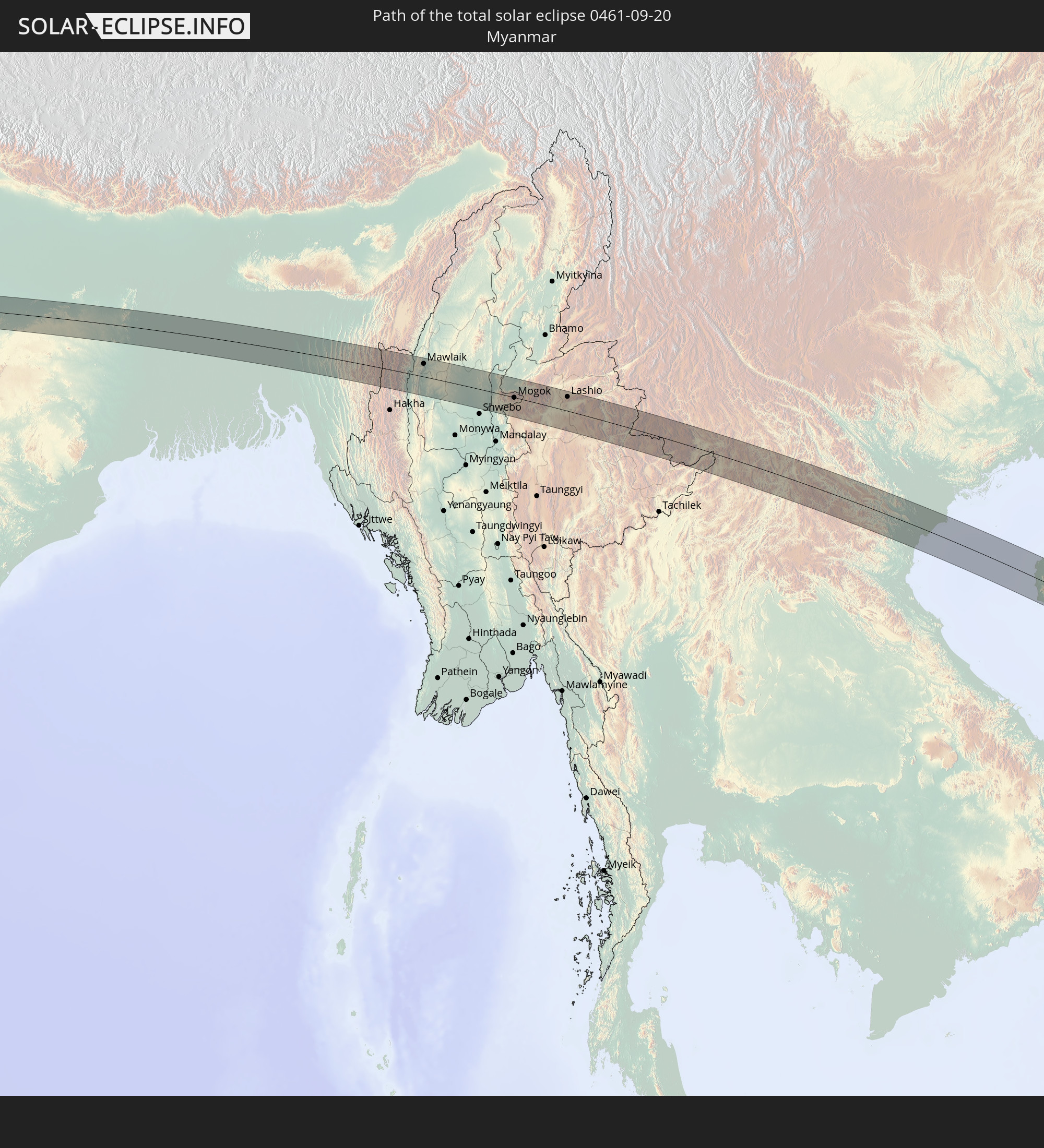 Myanmar
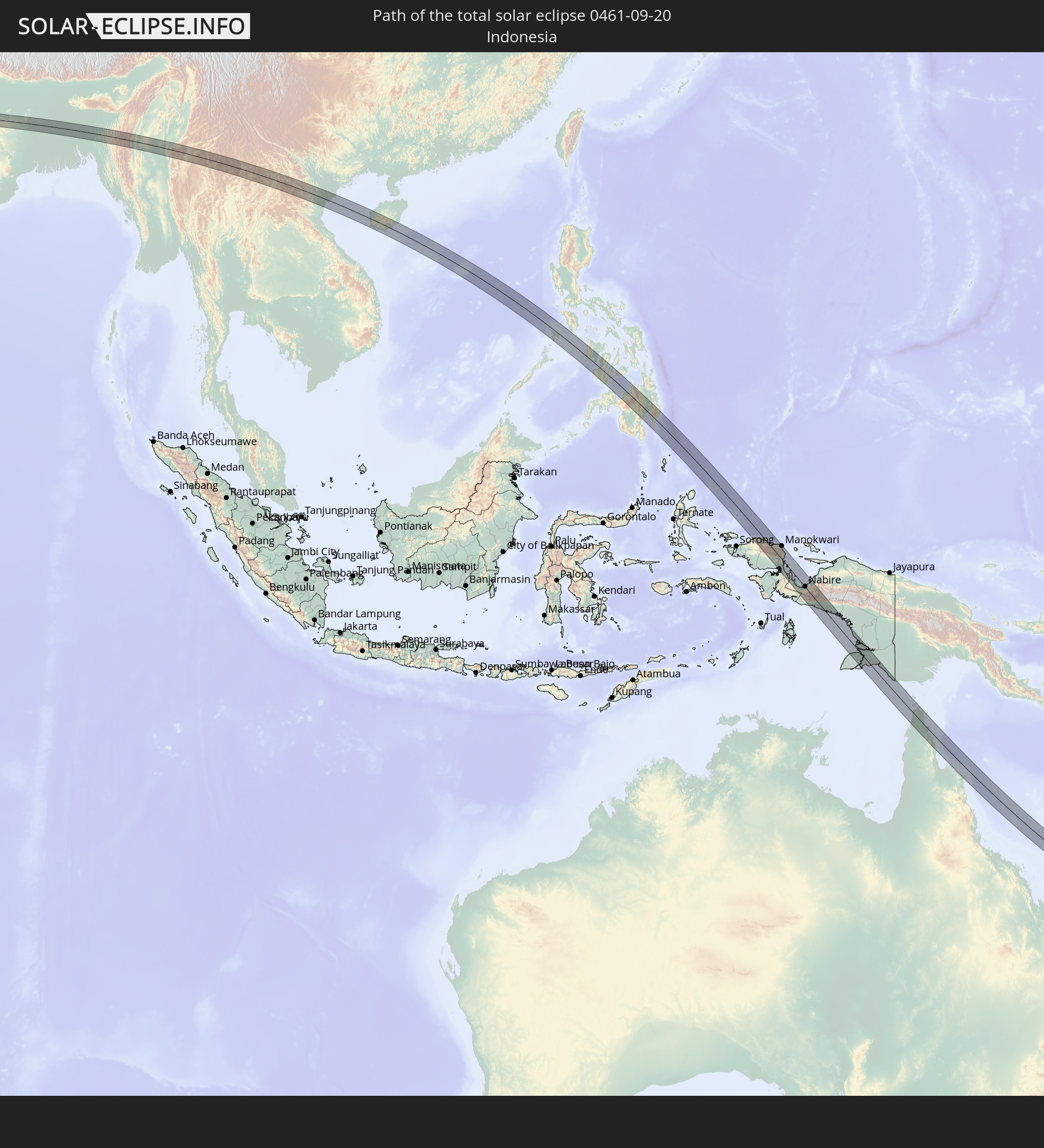 Indonesien
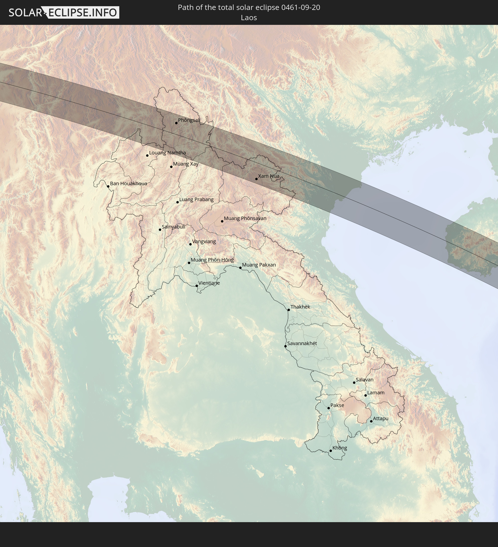 Laos
Laos
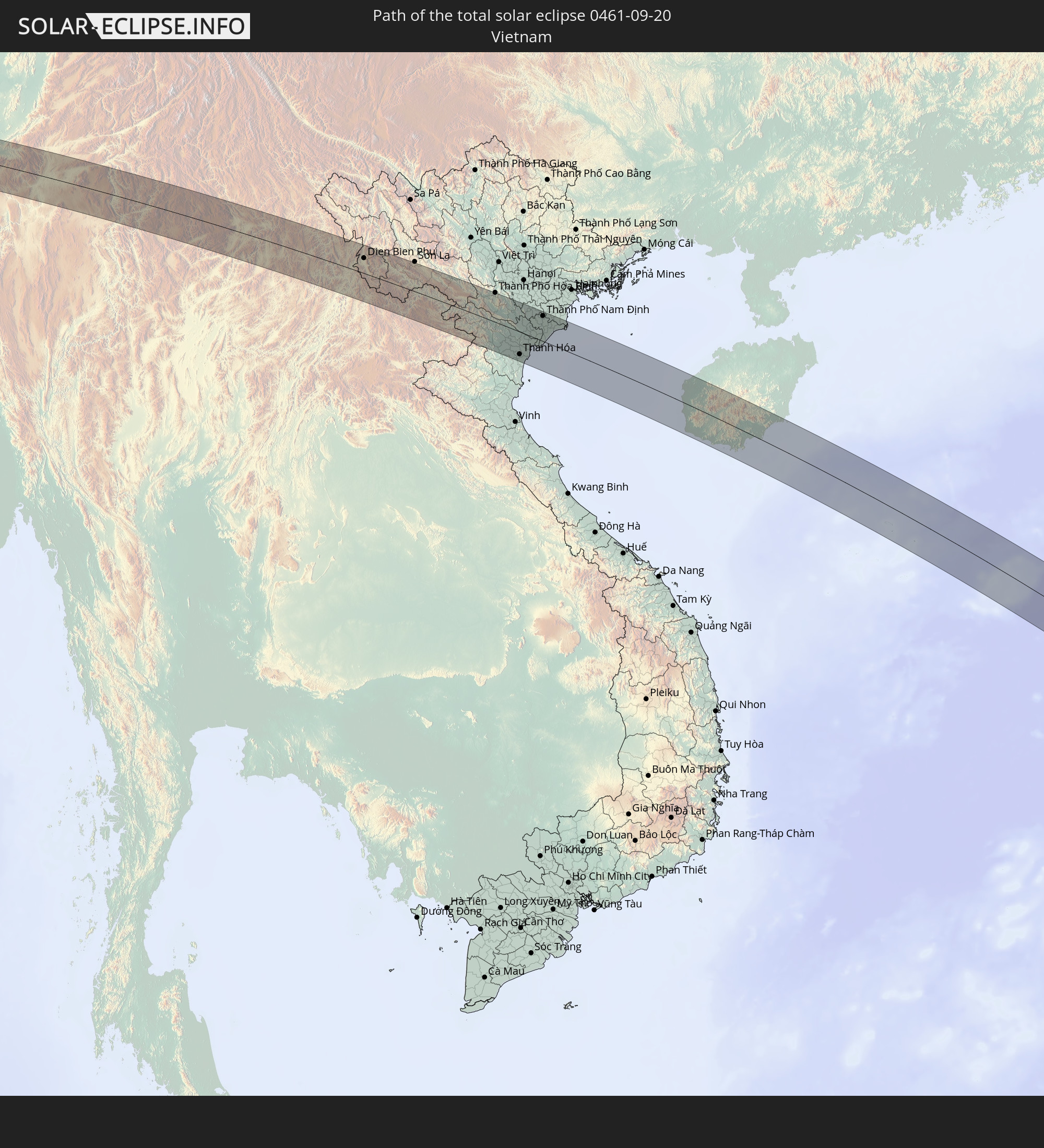 Vietnam
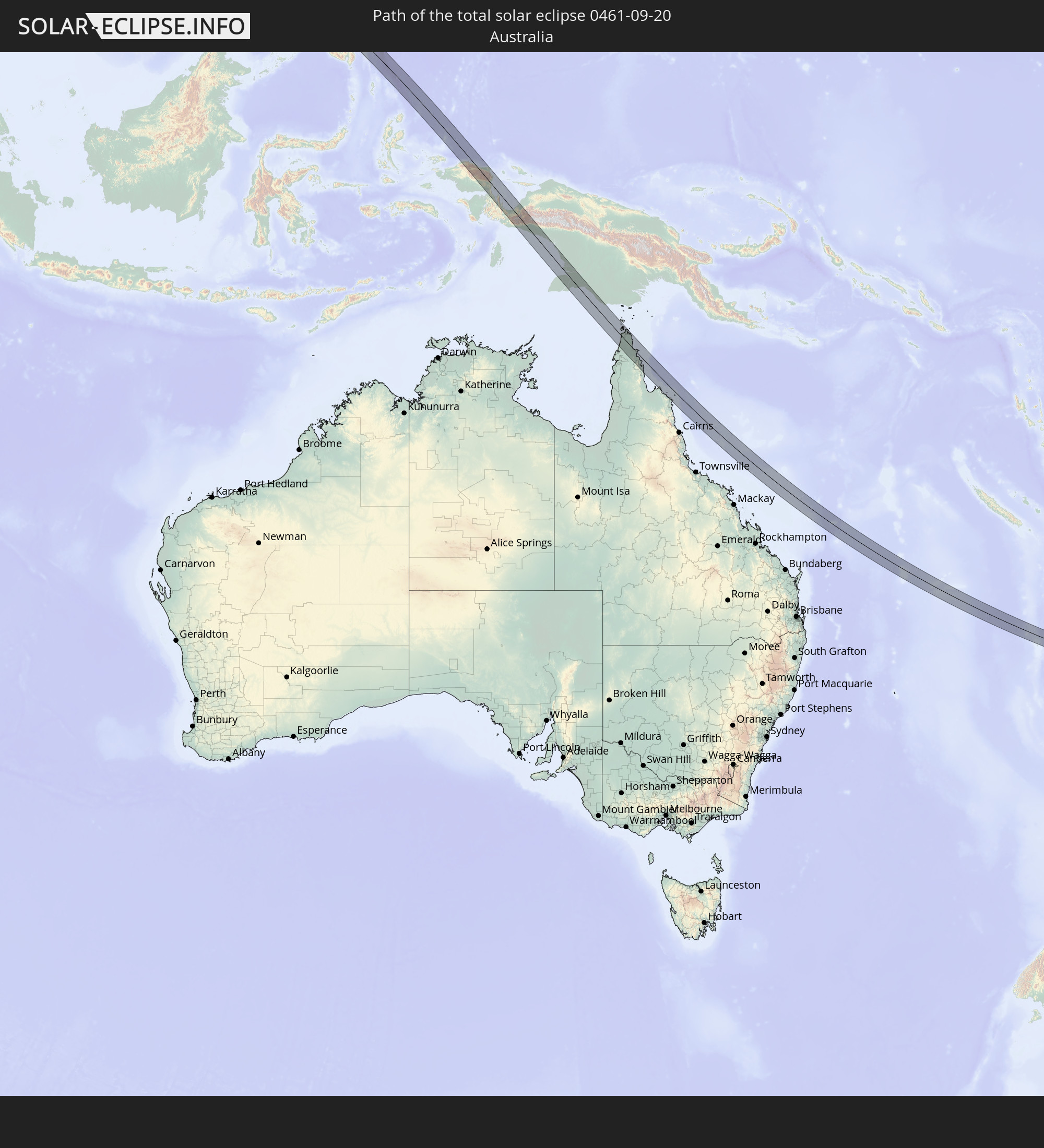 Australien
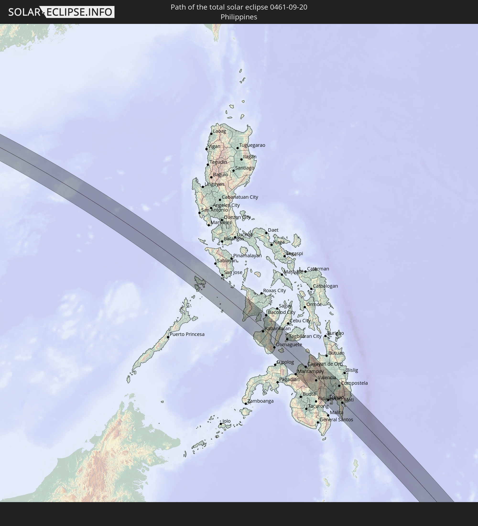 Philippinen
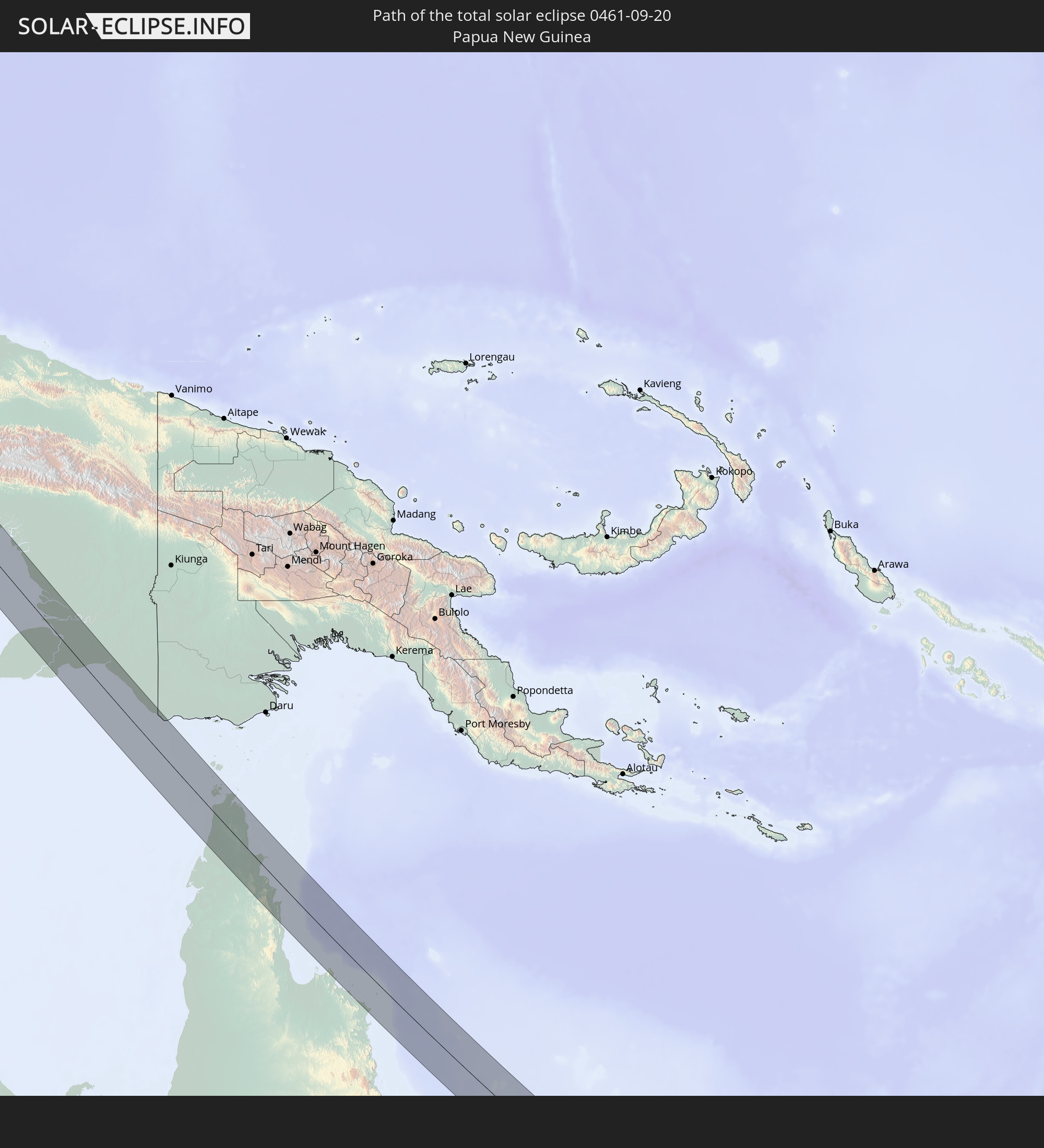 Papua-Neuguinea
In den folgenden Ländern ist die Sonnenfinsternis partiell zu sehen
 Fidschi
 Russland
 Neuseeland
 United States Minor Outlying Islands
 Wallis und Futuna
 Tonga
Tonga
 Kiribati
 Samoa
Samoa
 Tokelau
 Amerikanisch-Samoa
 Niue
Niue
 Cookinseln
 Kasachstan
 Usbekistan
 Afghanistan
 Pakistan
 Tadschikistan
 Indien
 Kirgisistan
 Britisches Territorium im Indischen Ozean
 Malediven
 Volksrepublik China
 Sri Lanka
 Nepal
Nepal
 Mongolei
 Bangladesch
 Bhutan
 Myanmar
 Indonesien
 Kokosinseln
 Thailand
 Malaysia
 Laos
Laos
 Vietnam
 Kambodscha
 Singapur
 Weihnachtsinsel
 Australien
 Macau
Macau
 Hongkong
 Brunei
 Taiwan
 Philippinen
 Japan
Japan
 Osttimor
 Nordkorea
 Südkorea
 Palau
Palau
 Föderierte Staaten von Mikronesien
 Papua-Neuguinea
 Guam
Guam
 Nördliche Marianen
 Salomonen
 Neukaledonien
 Marshallinseln
 Vanuatu
 Nauru
Nauru
 Norfolkinsel
 Tuvalu
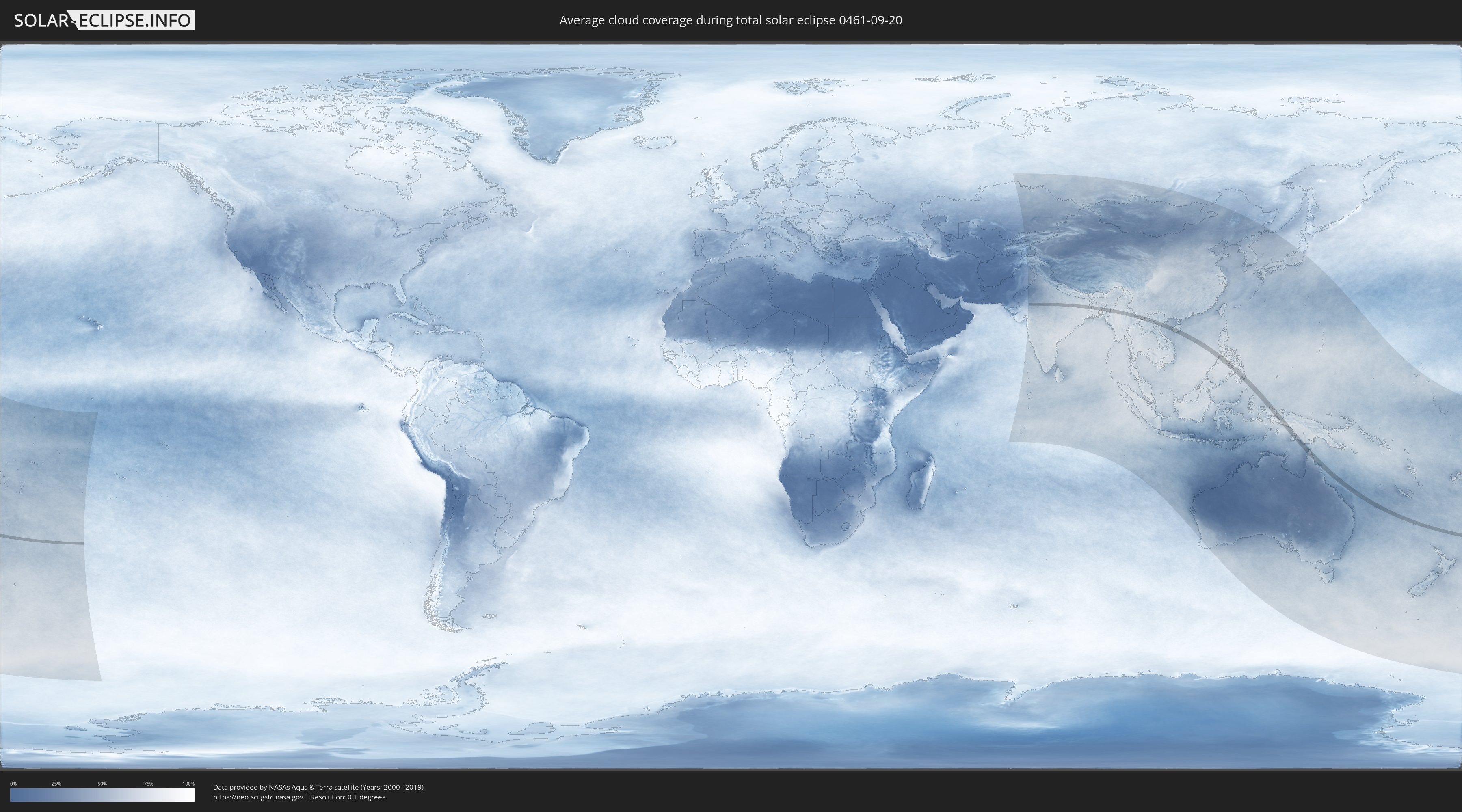
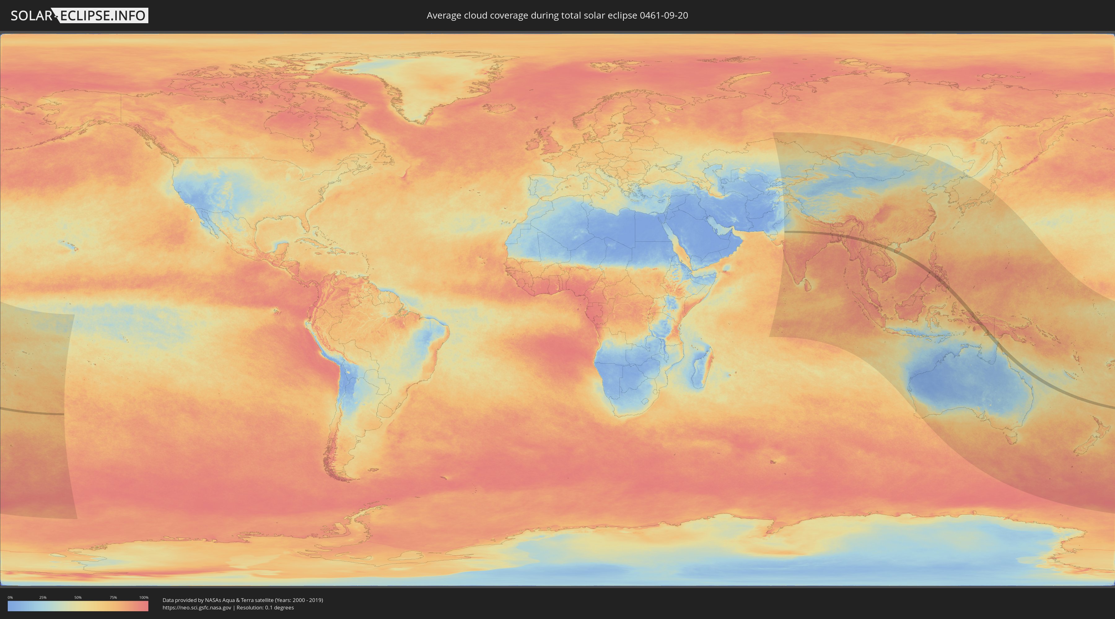
Wie wird das Wetter während der totalen Sonnenfinsternis am 20.09.0461?
Wo ist der beste Ort, um die totale Sonnenfinsternis vom 20.09.0461 zu beobachten?
Die folgenden Karten zeigen die durchschnittliche Bewölkung für den Tag, an dem die totale Sonnenfinsternis
stattfindet. Mit Hilfe der Karten lässt sich der Ort entlang des Finsternispfades eingrenzen,
der die besten Aussichen auf einen klaren wolkenfreien Himmel bietet.
Trotzdem muss man immer lokale Gegenenheiten beachten und sollte sich genau über das Wetter an seinem
gewählten Beobachtungsort informieren.
Die Daten stammen von den beiden NASA-Satelliten
AQUA und TERRA
und wurden über einen Zeitraum von 19 Jahren (2000 - 2019) gemittelt.
Detaillierte Länderkarten
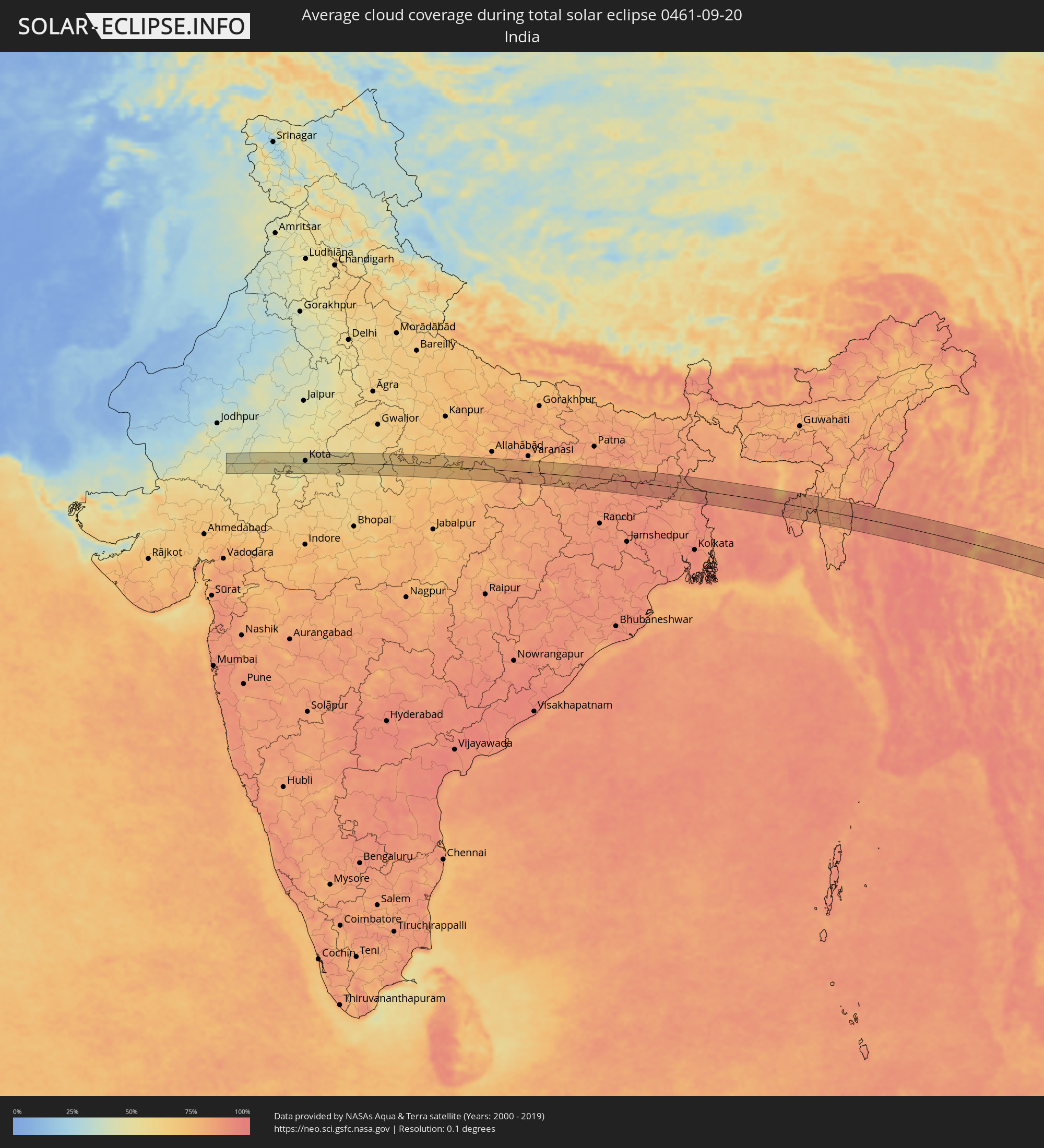 Indien
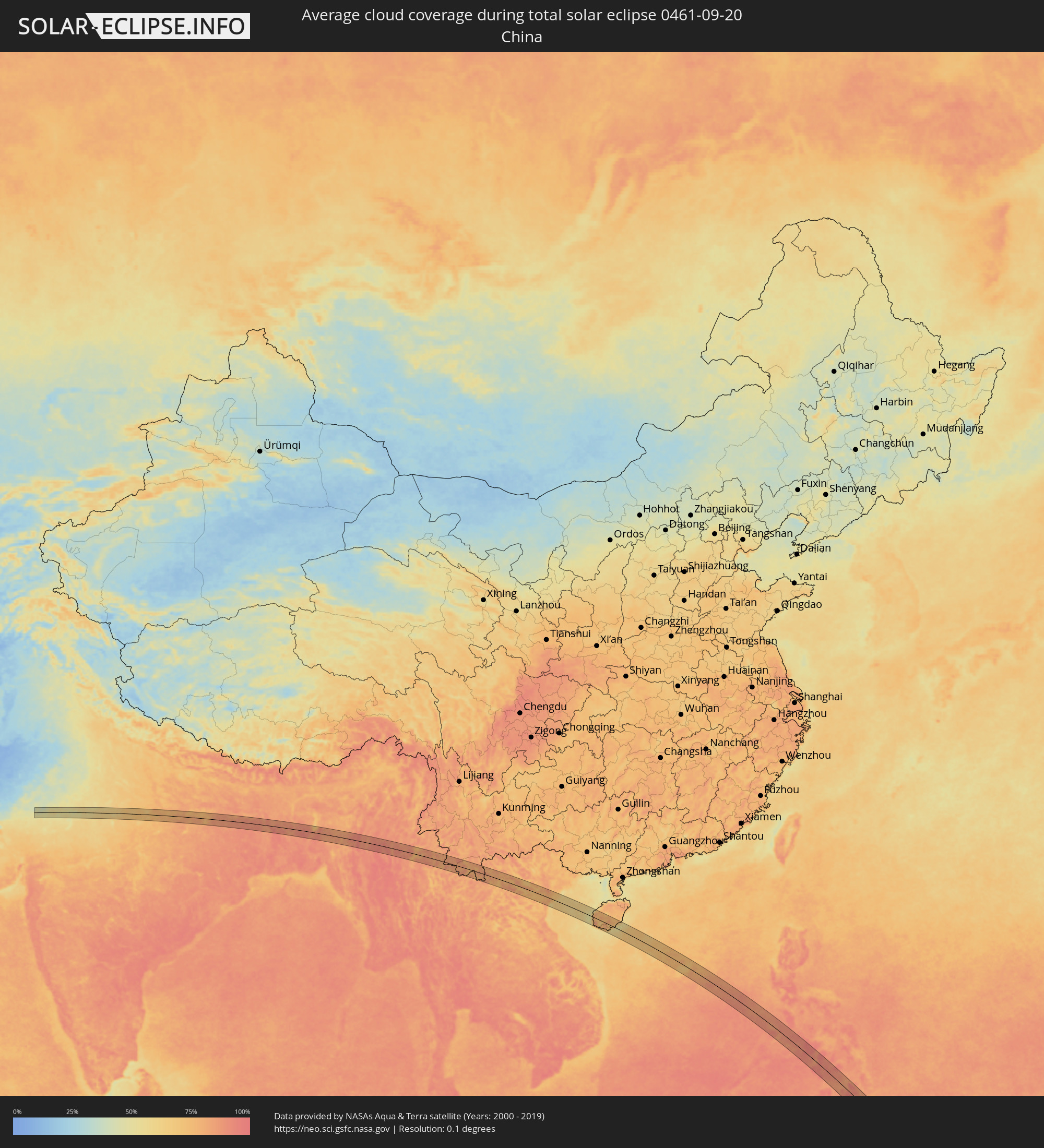 Volksrepublik China
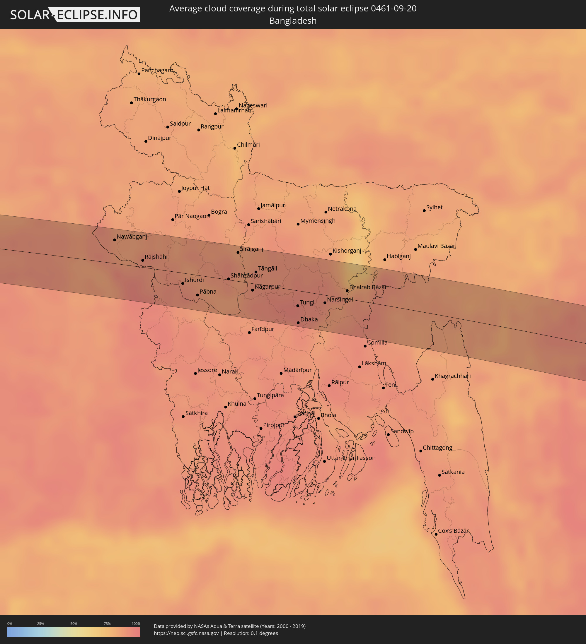 Bangladesch
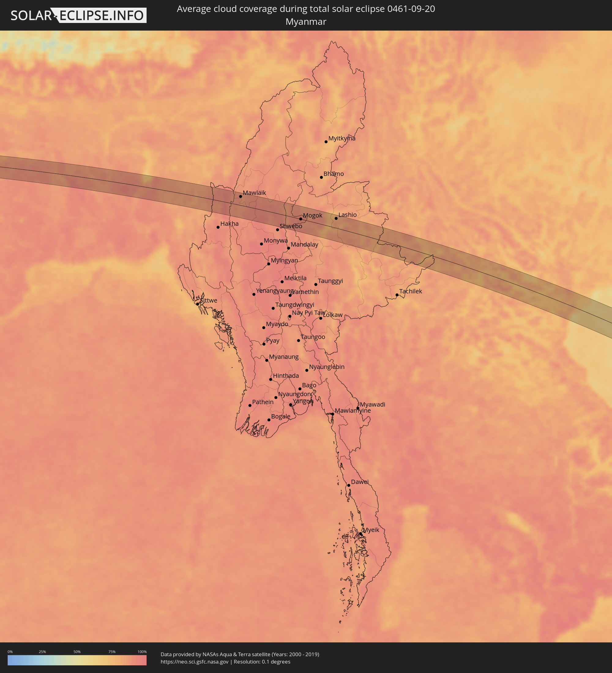 Myanmar
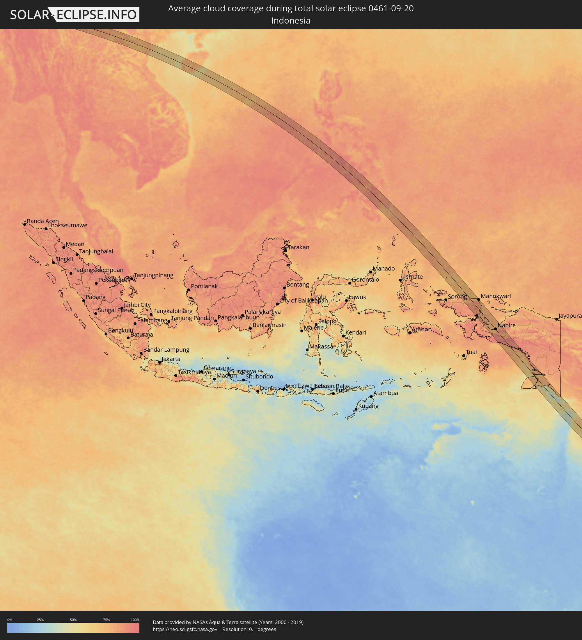 Indonesien
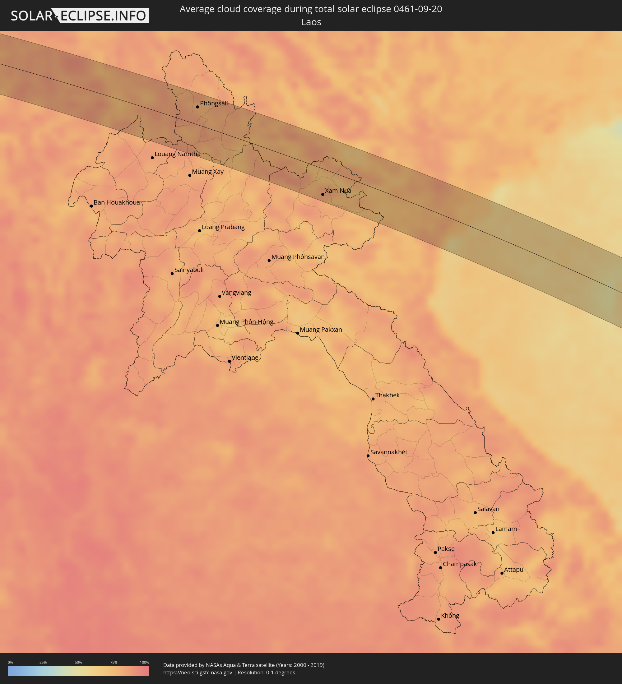 Laos
Laos
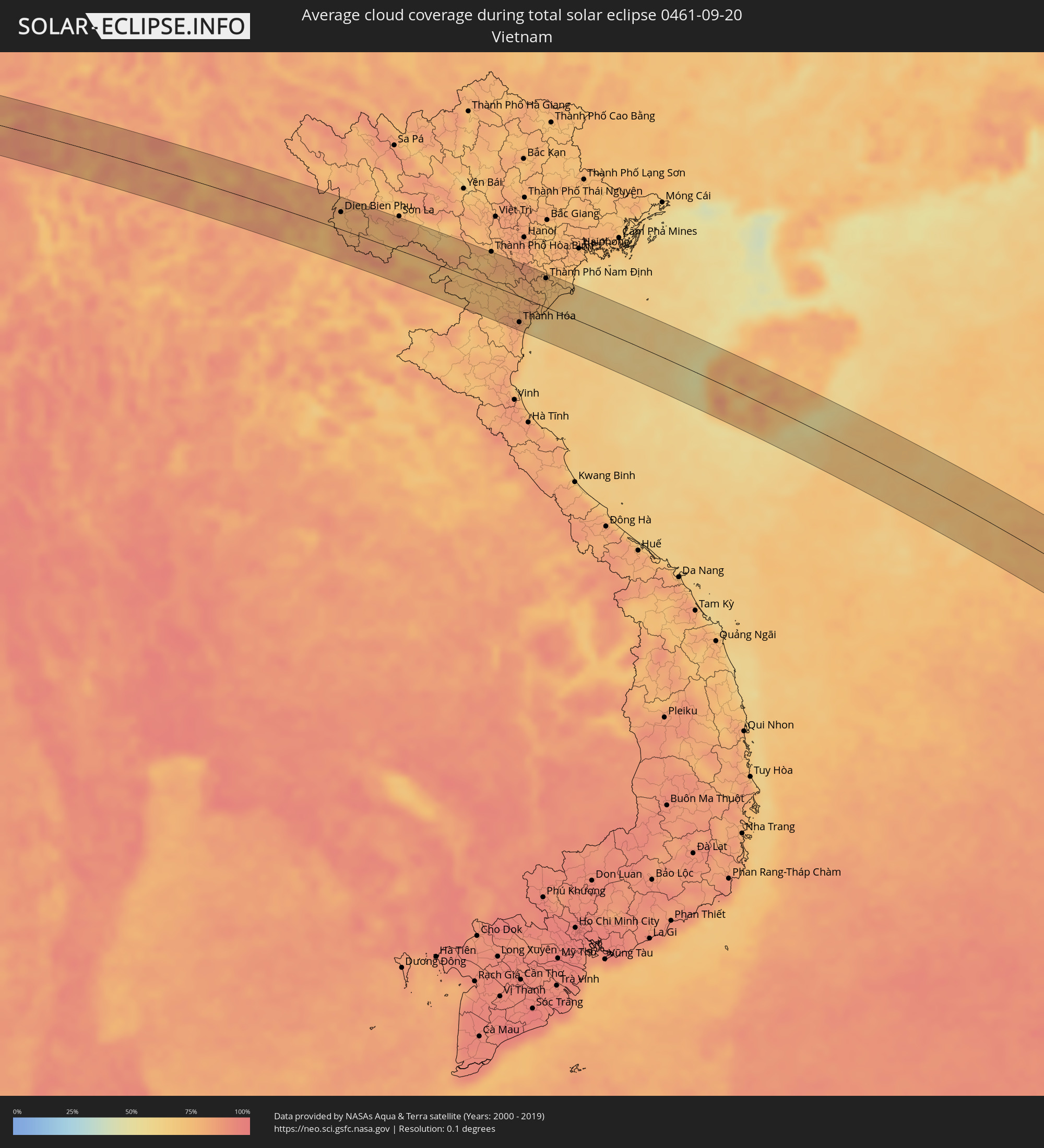 Vietnam
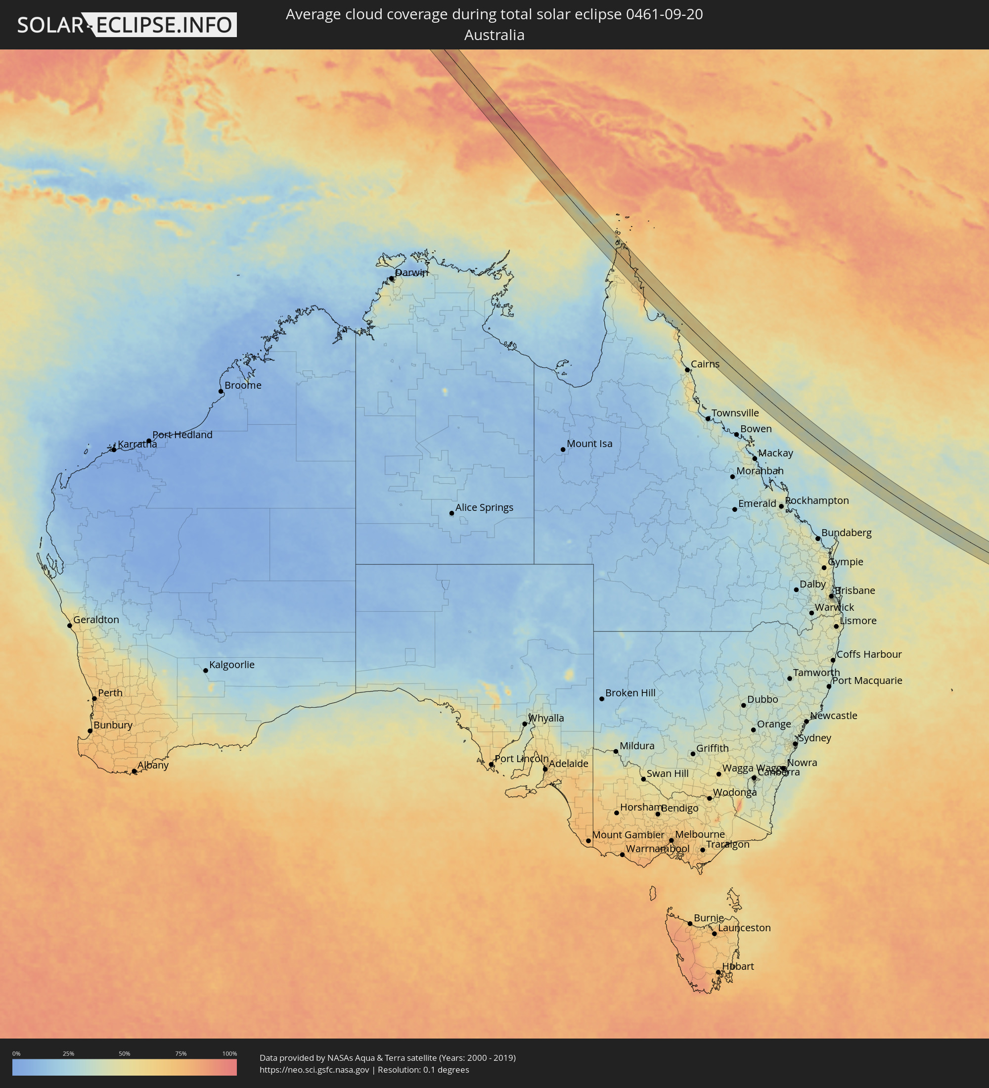 Australien
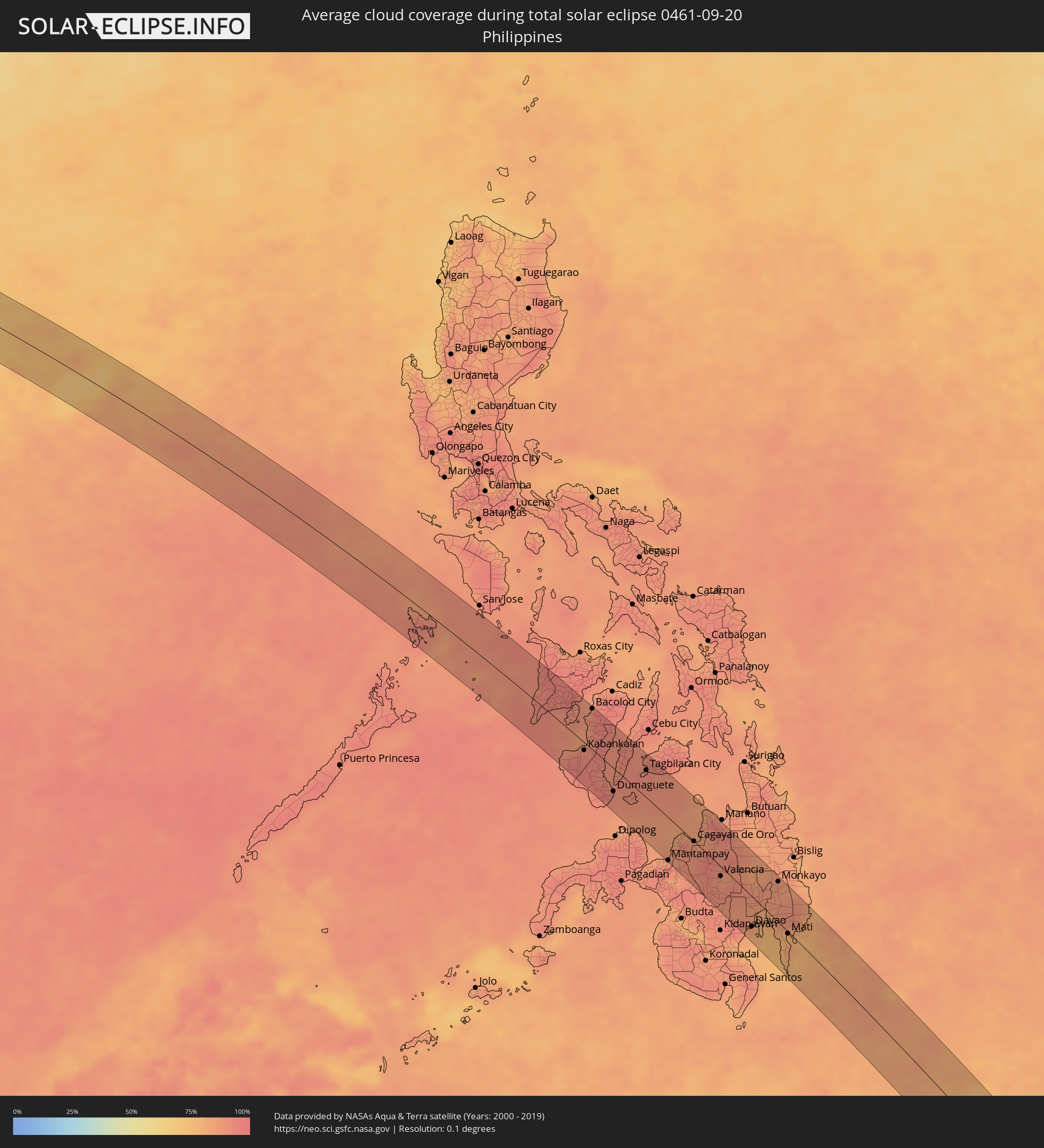 Philippinen
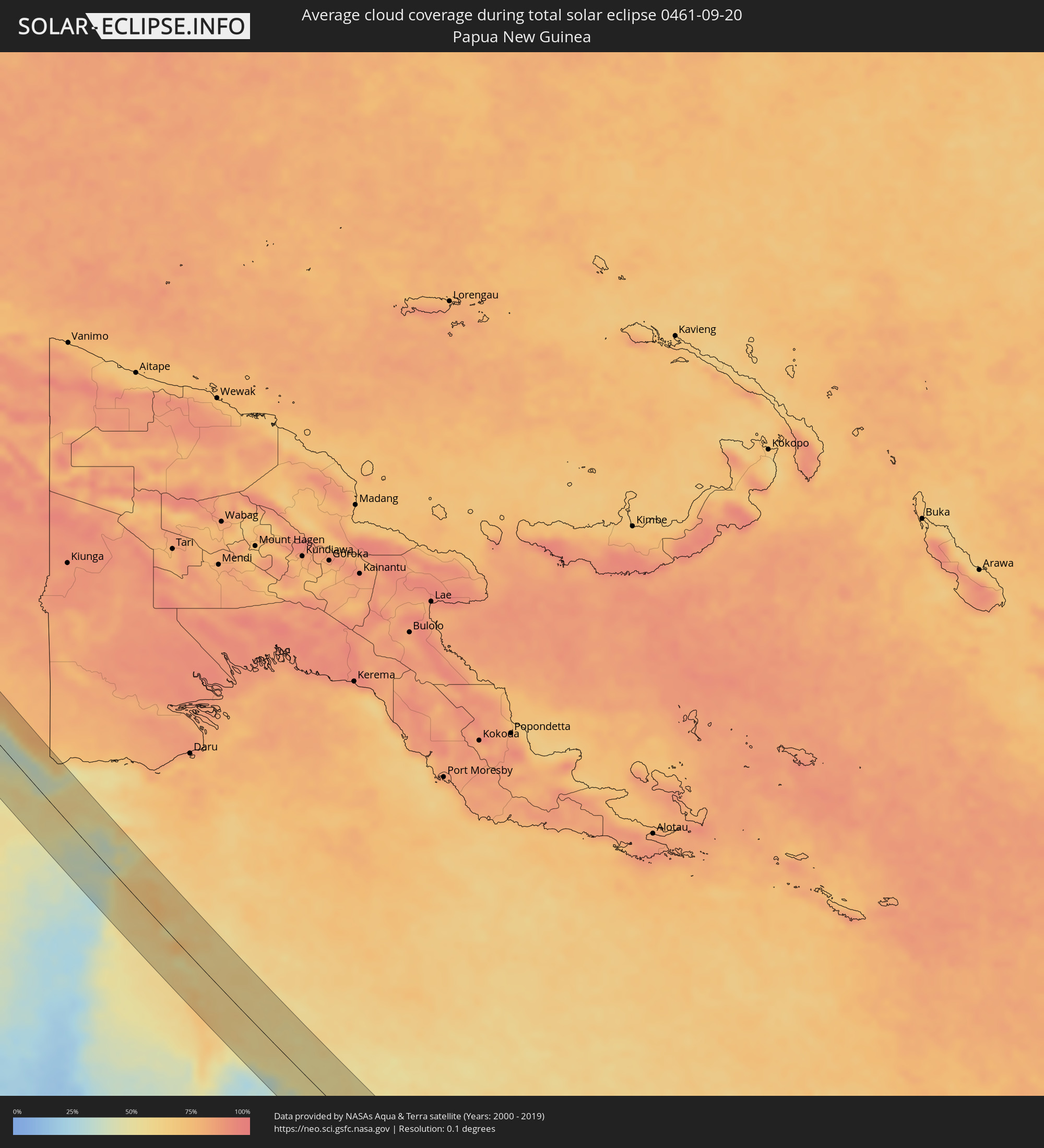 Papua-Neuguinea
Orte im Finsternispfad
Die nachfolgene Tabelle zeigt Städte und Orte mit mehr als 5.000 Einwohnern, die sich im Finsternispfad befinden. Städte mit mehr als 100.000 Einwohnern sind dick gekennzeichnet. Mit einem Klick auf den Ort öffnet sich eine Detailkarte die die Lage des jeweiligen Ortes zusammen mit dem Verlauf der zentralen Finsternis präsentiert.
| Ort | Typ | Dauer der Verfinsterung | Ortszeit bei maximaler Verfinsterung | Entfernung zur Zentrallinie | Ø Bewölkung |
|
Rājsamand, Rajasthan
|
total | - | 06:19:46 UTC+05:21 | 6 km | 50% |
|
Chittaurgarh, Rajasthan
|
total | - | 06:19:49 UTC+05:21 | 27 km | 51% |
|
Bhīlwāra, Rajasthan
|
total | - | 06:19:45 UTC+05:21 | 24 km | 55% |
|
Kota, Rajasthan
|
total | - | 06:19:50 UTC+05:21 | 6 km | 47% |
|
Bārān, Rajasthan
|
total | - | 06:19:54 UTC+05:21 | 2 km | 54% |
|
Chhatarpur, Madhya Pradesh
|
total | - | 06:20:20 UTC+05:21 | 13 km | 69% |
|
Mahobā, Uttar Pradesh
|
total | - | 06:20:19 UTC+05:21 | 29 km | 71% |
|
Panna, Madhya Pradesh
|
total | - | 06:20:29 UTC+05:21 | 33 km | 70% |
|
Mirzāpur, Uttar Pradesh
|
total | - | 06:20:55 UTC+05:21 | 29 km | 81% |
|
Bhabhua, Bihar
|
total | - | 06:21:13 UTC+05:21 | 26 km | 79% |
|
Dehri, Bihar
|
total | - | 06:21:25 UTC+05:21 | 15 km | 77% |
|
Aurangābād, Bihar
|
total | - | 06:21:31 UTC+05:21 | 1 km | 81% |
|
Gaya, Bihar
|
total | - | 06:21:42 UTC+05:21 | 11 km | 86% |
|
Bagaha, Bihar
|
total | - | 06:21:48 UTC+05:21 | 18 km | 85% |
|
Jumri Tilaiyā, Jharkhand
|
total | - | 06:21:59 UTC+05:21 | 23 km | 84% |
|
Nawāda, Bihar
|
total | - | 06:21:52 UTC+05:21 | 27 km | 87% |
|
Jamūī, Bihar
|
total | - | 06:22:06 UTC+05:21 | 39 km | 86% |
|
Madhupur, Jharkhand
|
total | - | 06:22:26 UTC+05:21 | 29 km | 90% |
|
Dumka, Jharkhand
|
total | - | 06:22:40 UTC+05:21 | 22 km | 88% |
|
Rampur Hat, West Bengal
|
total | - | 06:22:55 UTC+05:21 | 25 km | 86% |
|
Dhuliān, West Bengal
|
total | - | 06:22:50 UTC+05:21 | 33 km | 90% |
|
Jangipur, West Bengal
|
total | - | 06:22:57 UTC+05:21 | 11 km | 87% |
|
Shibganj, Rājshāhi
|
total | - | 06:55:05 UTC+05:53 | 36 km | 90% |
|
Baharampur, West Bengal
|
total | - | 06:23:08 UTC+05:21 | 27 km | 87% |
|
Nawābganj, Rājshāhi
|
total | - | 06:55:10 UTC+05:53 | 27 km | 86% |
|
Rājshāhi, Rājshāhi
|
total | - | 06:55:22 UTC+05:53 | 8 km | 90% |
|
Bherāmāra, Khulna
|
total | - | 06:55:40 UTC+05:53 | 25 km | 89% |
|
Ishurdi, Rājshāhi
|
total | - | 06:55:40 UTC+05:53 | 13 km | 92% |
|
Kushtia, Khulna
|
total | - | 06:55:46 UTC+05:53 | 37 km | 89% |
|
Pābna, Rājshāhi
|
total | - | 06:55:47 UTC+05:53 | 23 km | 86% |
|
Shāhzādpur, Rājshāhi
|
total | - | 06:55:54 UTC+05:53 | 1 km | 89% |
|
Bera, Rājshāhi
|
total | - | 06:55:57 UTC+05:53 | 10 km | 85% |
|
Sirājganj, Rājshāhi
|
total | - | 06:55:51 UTC+05:53 | 33 km | 88% |
|
Nāgarpur, Dhaka
|
total | - | 06:56:04 UTC+05:53 | 8 km | 90% |
|
Tāngāil, Dhaka
|
total | - | 06:56:01 UTC+05:53 | 14 km | 90% |
|
Mirzāpur, Dhaka
|
total | - | 06:56:10 UTC+05:53 | 0 km | 93% |
|
Sakhipur, Dhaka
|
total | - | 06:56:07 UTC+05:53 | 25 km | 89% |
|
Azimpur, Dhaka
|
total | - | 06:56:26 UTC+05:53 | 36 km | 91% |
|
Tungi, Dhaka
|
total | - | 06:56:23 UTC+05:53 | 18 km | 94% |
|
Dhaka, Dhaka
|
total | - | 06:56:28 UTC+05:53 | 38 km | 91% |
|
Paltan, Dhaka
|
total | - | 06:56:27 UTC+05:53 | 35 km | 91% |
|
Narsingdi, Dhaka
|
total | - | 06:56:32 UTC+05:53 | 9 km | 89% |
|
Bājitpur, Dhaka
|
total | - | 06:56:33 UTC+05:53 | 27 km | 81% |
|
Nabīnagar, Chittagong
|
total | - | 06:56:41 UTC+05:53 | 9 km | 88% |
|
Bhairab Bāzār, Dhaka
|
total | - | 06:56:37 UTC+05:53 | 9 km | 86% |
|
Agartala, Tripura
|
total | - | 06:24:42 UTC+05:21 | 9 km | 91% |
|
Aizawl, Mizoram
|
total | - | 06:25:32 UTC+05:21 | 5 km | 83% |
|
Mawlaik, Sagain
|
total | - | 07:30:12 UTC+06:24 | 30 km | 85% |
|
Mogok, Mandalay
|
total | - | 07:31:58 UTC+06:24 | 1 km | 89% |
|
Lashio, Shan
|
total | - | 07:32:51 UTC+06:24 | 33 km | 86% |
|
Jinghong, Yunnan
|
total | - | 09:11:02 UTC+08:00 | 16 km | 80% |
|
Phôngsali, Phôngsali
|
total | - | 07:54:31 UTC+06:42 | 27 km | 84% |
|
Dien Bien Phu, Tỉnh Ðiện Biên
|
total | - | 08:20:11 UTC+07:06 | 26 km | 76% |
|
Xam Nua, Houaphan
|
total | - | 07:57:19 UTC+06:42 | 39 km | 81% |
|
Thành Phố Hòa Bình, Hòa Bình
|
total | - | 08:22:54 UTC+07:06 | 50 km | 73% |
|
Thanh Hóa, Thanh Hóa
|
total | - | 08:24:12 UTC+07:06 | 38 km | 80% |
|
Bỉm Sơn, Thanh Hóa
|
total | - | 08:24:04 UTC+07:06 | 6 km | 82% |
|
Thành Phố Phủ Lý, Hà Nam
|
total | - | 08:23:43 UTC+07:06 | 44 km | 80% |
|
Thành Phố Ninh Bình, Ninh Bình
|
total | - | 08:24:02 UTC+07:06 | 17 km | 79% |
|
Thành Phố Nam Định, Nam Định
|
total | - | 08:24:05 UTC+07:06 | 43 km | 71% |
|
Sanya, Hainan
|
total | - | 09:23:17 UTC+08:00 | 38 km | 61% |
|
Iloilo, Western Visayas
|
total | - | 09:52:50 UTC+08:00 | 32 km | 91% |
|
Kabankalan, Western Visayas
|
total | - | 09:54:30 UTC+08:00 | 11 km | 92% |
|
Bago City, Western Visayas
|
total | - | 09:53:34 UTC+08:00 | 37 km | 87% |
|
Hinigaran, Western Visayas
|
total | - | 09:54:03 UTC+08:00 | 16 km | 88% |
|
La Carlota, Western Visayas
|
total | - | 09:53:54 UTC+08:00 | 34 km | 88% |
|
Bacolod City, Western Visayas
|
total | - | 09:53:31 UTC+08:00 | 56 km | 94% |
|
Bais, Central Visayas
|
total | - | 09:55:44 UTC+08:00 | 21 km | 91% |
|
Canlaon, Central Visayas
|
total | - | 09:54:28 UTC+08:00 | 53 km | 94% |
|
Dumaguete, Central Visayas
|
total | - | 09:56:33 UTC+08:00 | 32 km | 90% |
|
Carcar, Central Visayas
|
total | - | 09:55:40 UTC+08:00 | 59 km | 91% |
|
Tagbilaran City, Central Visayas
|
total | - | 09:56:50 UTC+08:00 | 37 km | 92% |
|
Mantampay, Northern Mindanao
|
total | - | 10:00:12 UTC+08:00 | 58 km | 87% |
|
Iligan City, Soccsksargen
|
total | - | 10:00:22 UTC+08:00 | 37 km | 88% |
|
Cagayan de Oro, Northern Mindanao
|
total | - | 10:00:21 UTC+08:00 | 1 km | 88% |
|
Manolo Fortich, Northern Mindanao
|
total | - | 10:00:56 UTC+08:00 | 7 km | 91% |
|
Maramag, Northern Mindanao
|
total | - | 10:02:20 UTC+08:00 | 31 km | 90% |
|
Valencia, Northern Mindanao
|
total | - | 10:02:13 UTC+08:00 | 13 km | 85% |
|
Malaybalay, Northern Mindanao
|
total | - | 10:01:48 UTC+08:00 | 10 km | 92% |
|
Davao, Davao
|
total | - | 10:04:43 UTC+08:00 | 40 km | 86% |
|
Panabo, Davao
|
total | - | 10:04:23 UTC+08:00 | 16 km | 81% |
|
Tagum, Davao
|
total | - | 10:04:20 UTC+08:00 | 5 km | 81% |
|
Lupon, Davao
|
total | - | 10:05:45 UTC+08:00 | 23 km | 77% |
|
Monkayo, Davao
|
total | - | 10:04:03 UTC+08:00 | 53 km | 86% |
|
Compostela, Davao
|
total | - | 10:04:23 UTC+08:00 | 45 km | 86% |
|
Mati, Davao
|
total | - | 10:06:00 UTC+08:00 | 2 km | 80% |
|
Manokwari, West Papua
|
total | - | 11:59:24 UTC+09:22 | 59 km | 78% |
|
Nabire, Papua
|
total | - | 12:07:30 UTC+09:22 | 3 km | 78% |