Totale Sonnenfinsternis vom 19.05.0467
| Wochentag: | Donnerstag |
| Maximale Dauer der Verfinsterung: | 02m33s |
| Maximale Breite des Finsternispfades: | 231 km |
| Saroszyklus: | 74 |
| Bedeckungsgrad: | 100% |
| Magnitude: | 1.0403 |
| Gamma: | 0.8094 |
Wo kann man die Sonnenfinsternis vom 19.05.0467 sehen?
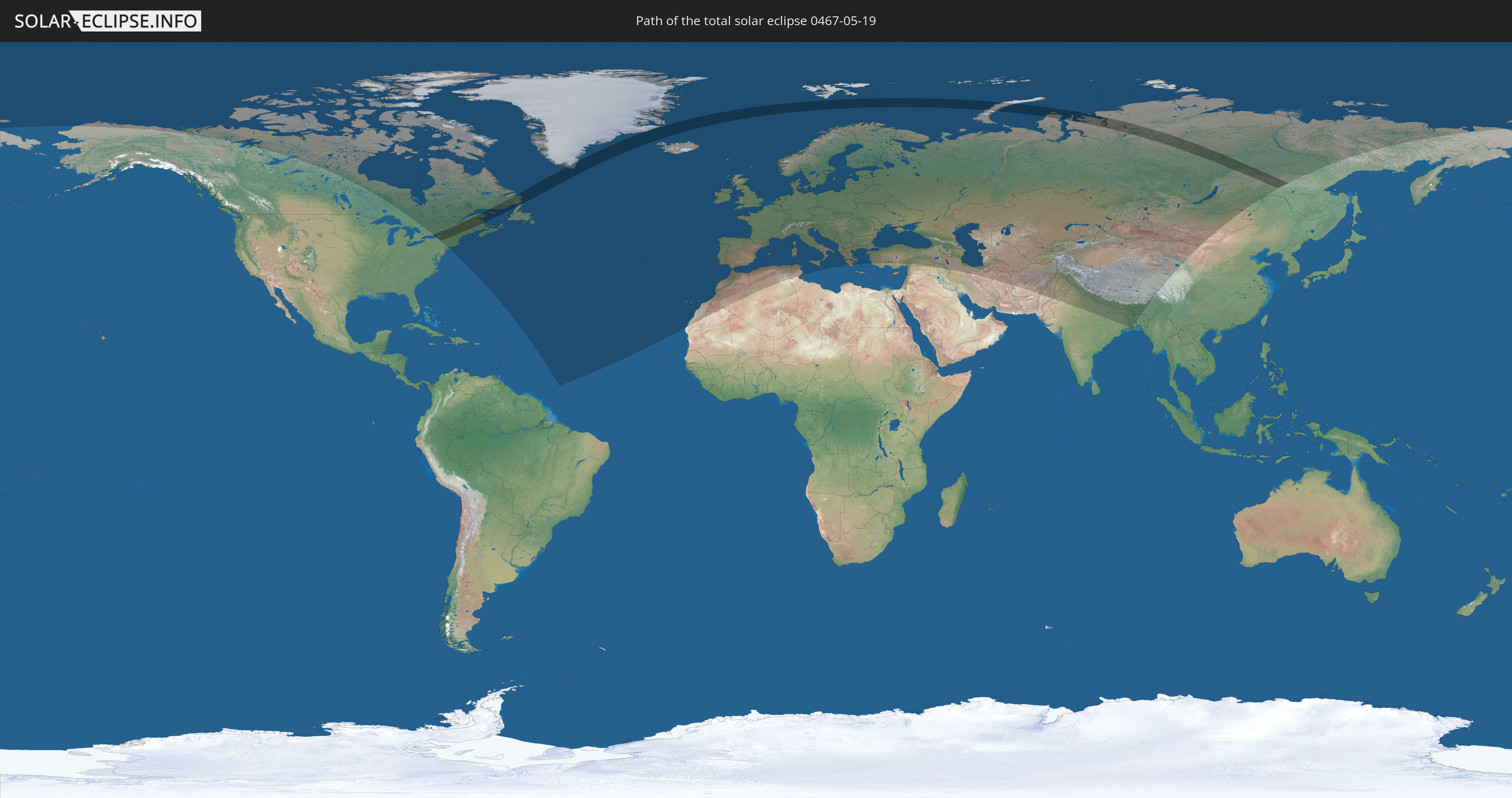
Die Sonnenfinsternis am 19.05.0467 kann man in 79 Ländern als partielle Sonnenfinsternis beobachten.
Der Finsternispfad verläuft durch 5 Länder. Nur in diesen Ländern ist sie als totale Sonnenfinsternis zu sehen.
In den folgenden Ländern ist die Sonnenfinsternis total zu sehen
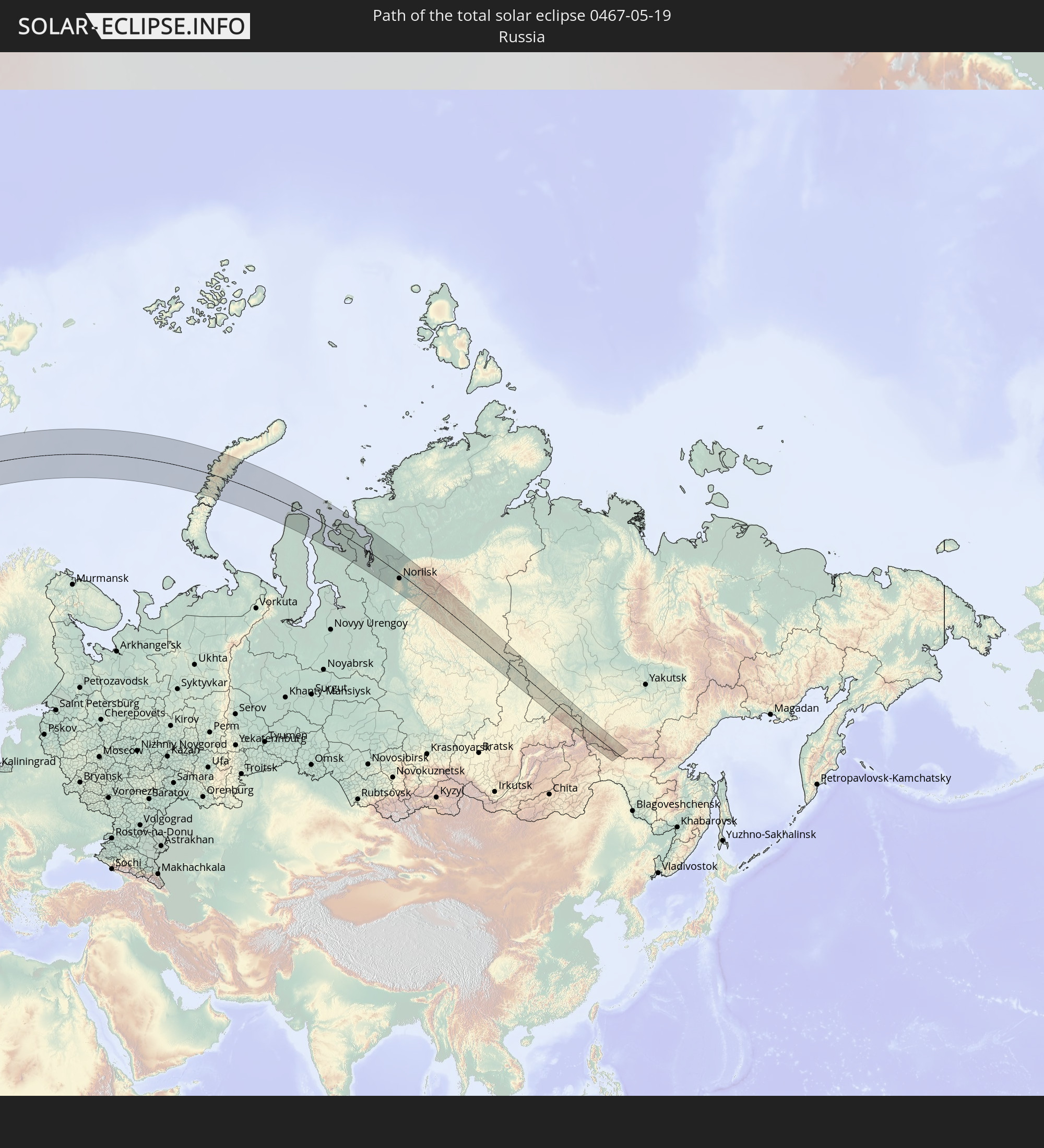 Russland
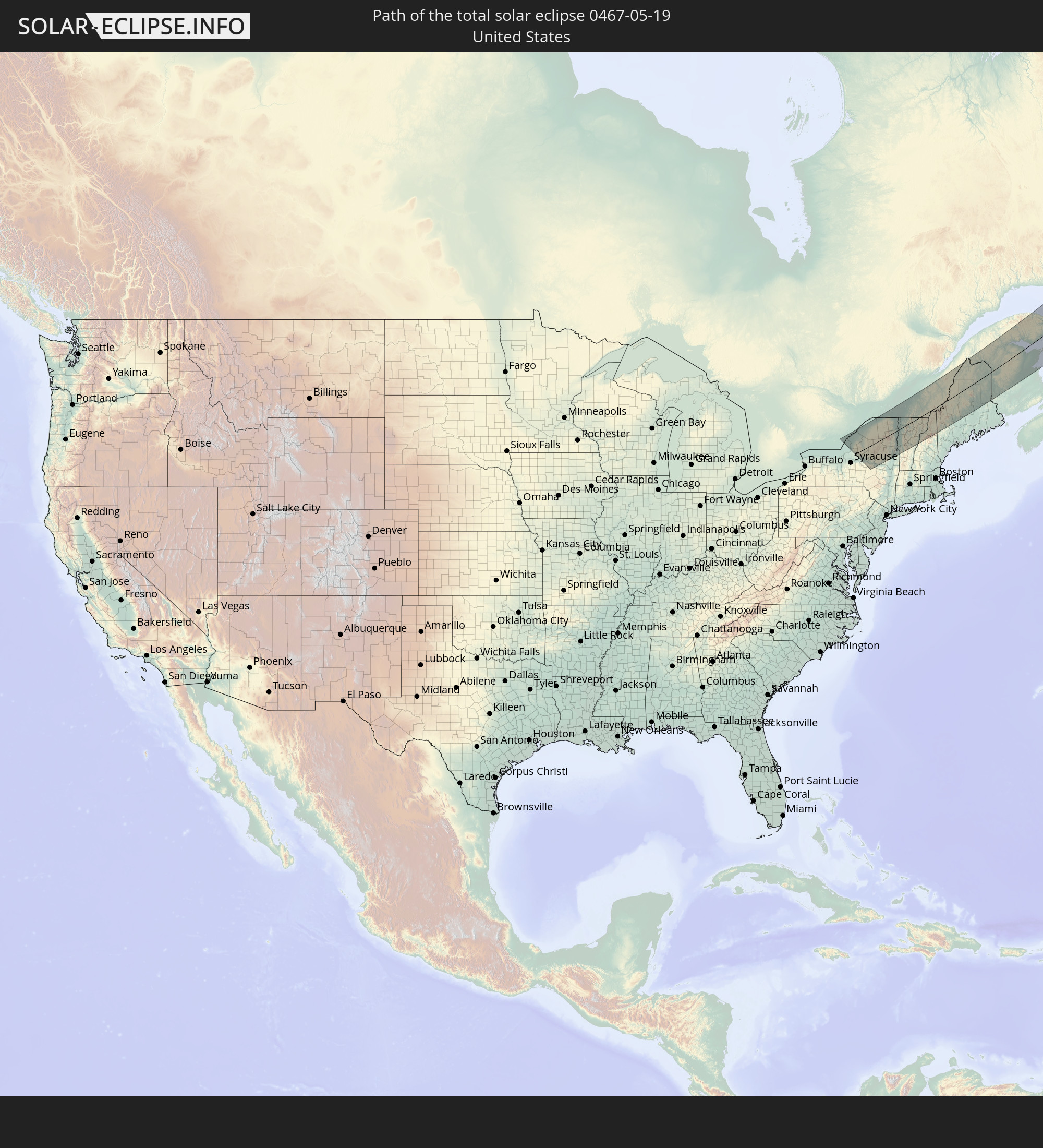 Vereinigte Staaten
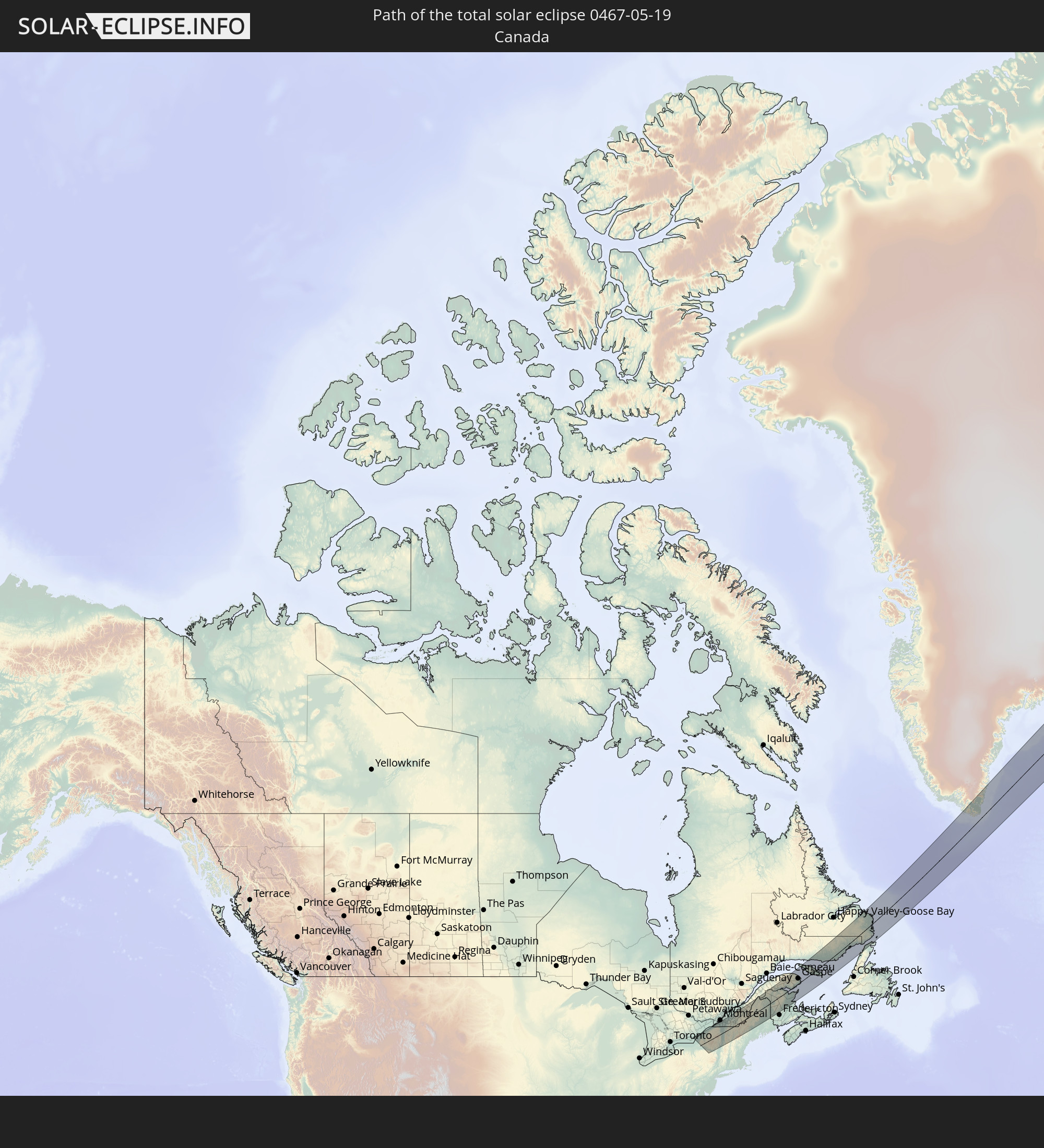 Kanada
 Grönland
 Spitzbergen
In den folgenden Ländern ist die Sonnenfinsternis partiell zu sehen
 Russland
 Vereinigte Staaten
 Kanada
 Grönland
 Saint-Pierre und Miquelon
 Portugal
 Island
 Spanien
 Mauretanien
 Marokko
 Irland
 Spitzbergen
 Algerien
 Vereinigtes Königreich
 Färöer
 Gibraltar
 Frankreich
 Isle of Man
 Guernsey
 Jersey
 Andorra
 Belgien
 Niederlande
 Norwegen
 Luxemburg
 Deutschland
 Schweiz
 Italien
 Monaco
 Tunesien
 Dänemark
 Liechtenstein
 Österreich
 Schweden
 Tschechien
 San Marino
 Vatikanstadt
 Slowenien
 Kroatien
 Polen
Polen
 Malta
Malta
 Bosnien und Herzegowina
 Ungarn
 Slowakei
 Montenegro
 Serbien
 Albanien
 Åland Islands
 Griechenland
 Rumänien
 Mazedonien
 Finnland
 Litauen
 Lettland
 Estland
 Ukraine
 Bulgarien
 Weißrussland
 Türkei
 Moldawien
 Syrien
 Irak
Irak
 Georgien
 Armenien
 Iran
Iran
 Aserbaidschan
 Kasachstan
 Turkmenistan
 Usbekistan
 Afghanistan
 Pakistan
 Tadschikistan
 Indien
 Kirgisistan
 Volksrepublik China
 Nepal
Nepal
 Mongolei
 Bangladesch
 Bhutan
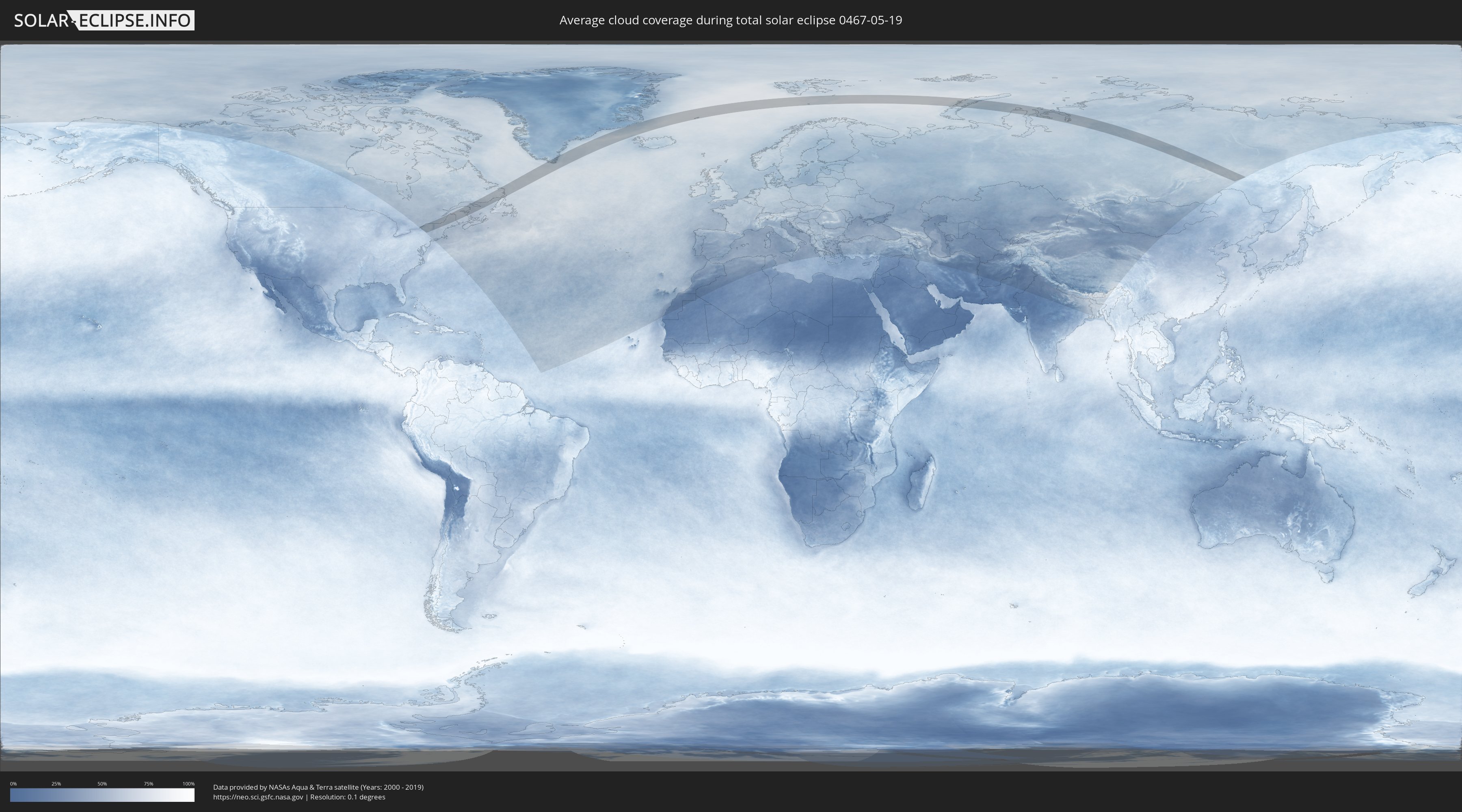
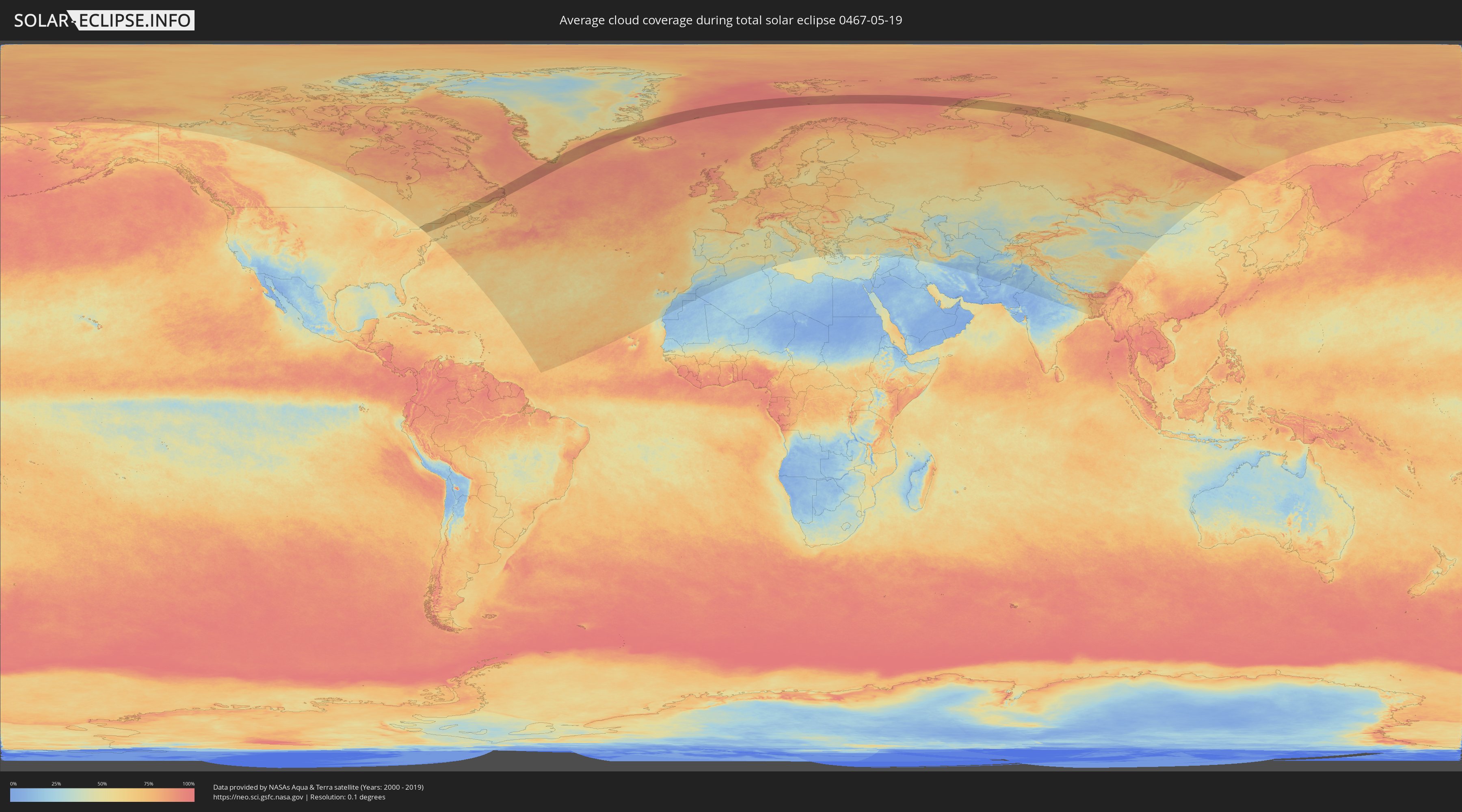
Wie wird das Wetter während der totalen Sonnenfinsternis am 19.05.0467?
Wo ist der beste Ort, um die totale Sonnenfinsternis vom 19.05.0467 zu beobachten?
Die folgenden Karten zeigen die durchschnittliche Bewölkung für den Tag, an dem die totale Sonnenfinsternis
stattfindet. Mit Hilfe der Karten lässt sich der Ort entlang des Finsternispfades eingrenzen,
der die besten Aussichen auf einen klaren wolkenfreien Himmel bietet.
Trotzdem muss man immer lokale Gegenenheiten beachten und sollte sich genau über das Wetter an seinem
gewählten Beobachtungsort informieren.
Die Daten stammen von den beiden NASA-Satelliten
AQUA und TERRA
und wurden über einen Zeitraum von 19 Jahren (2000 - 2019) gemittelt.
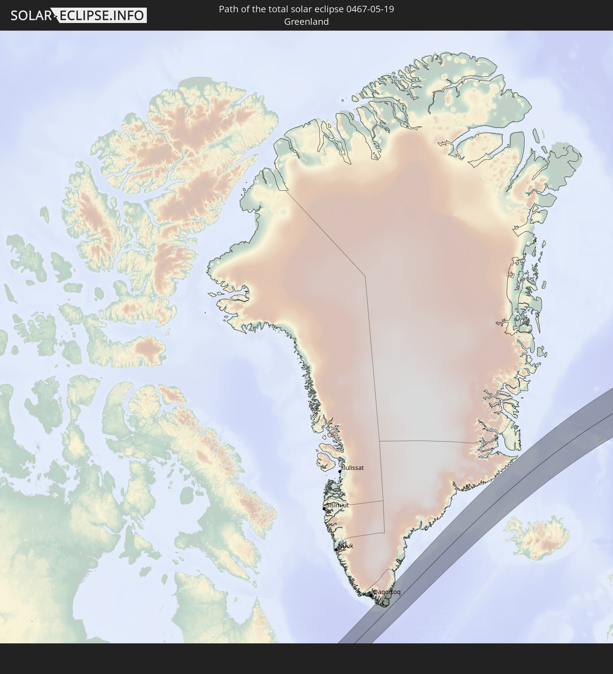
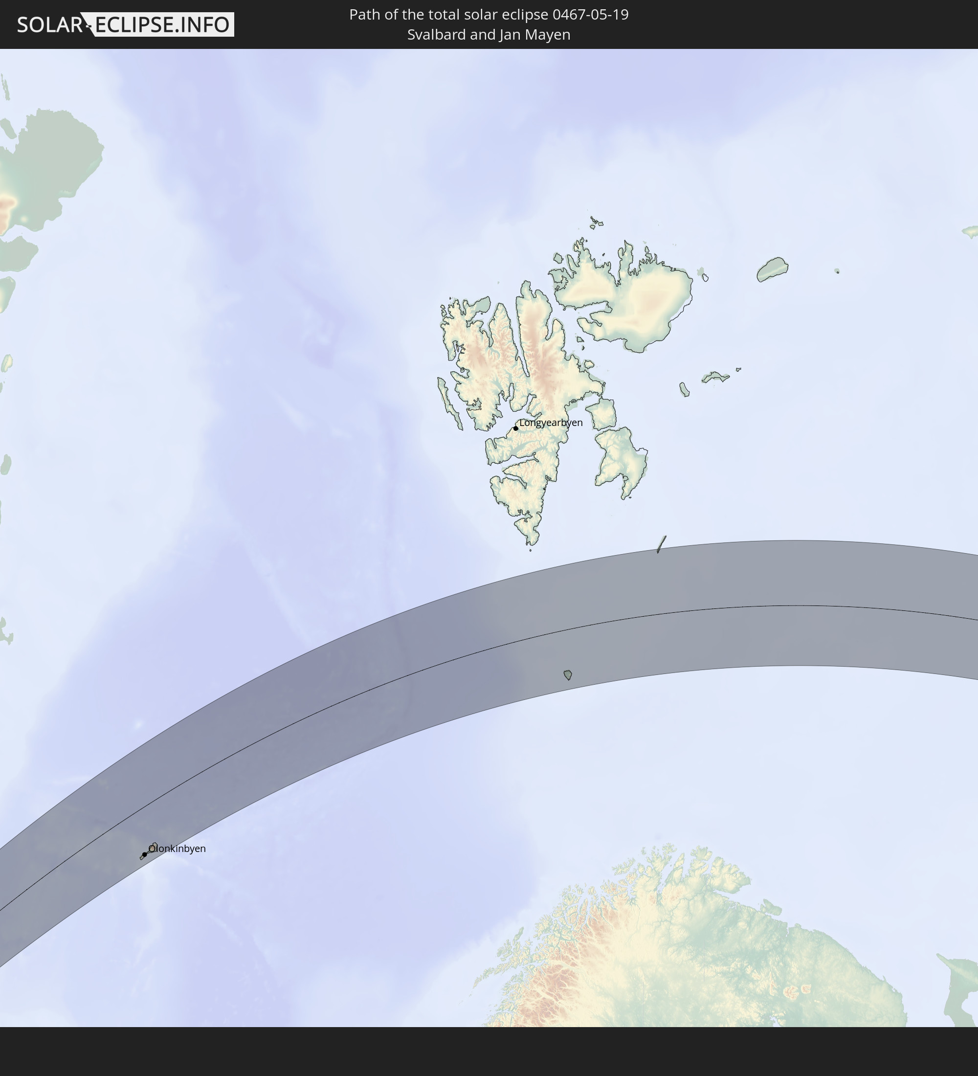
Detaillierte Länderkarten
 Russland
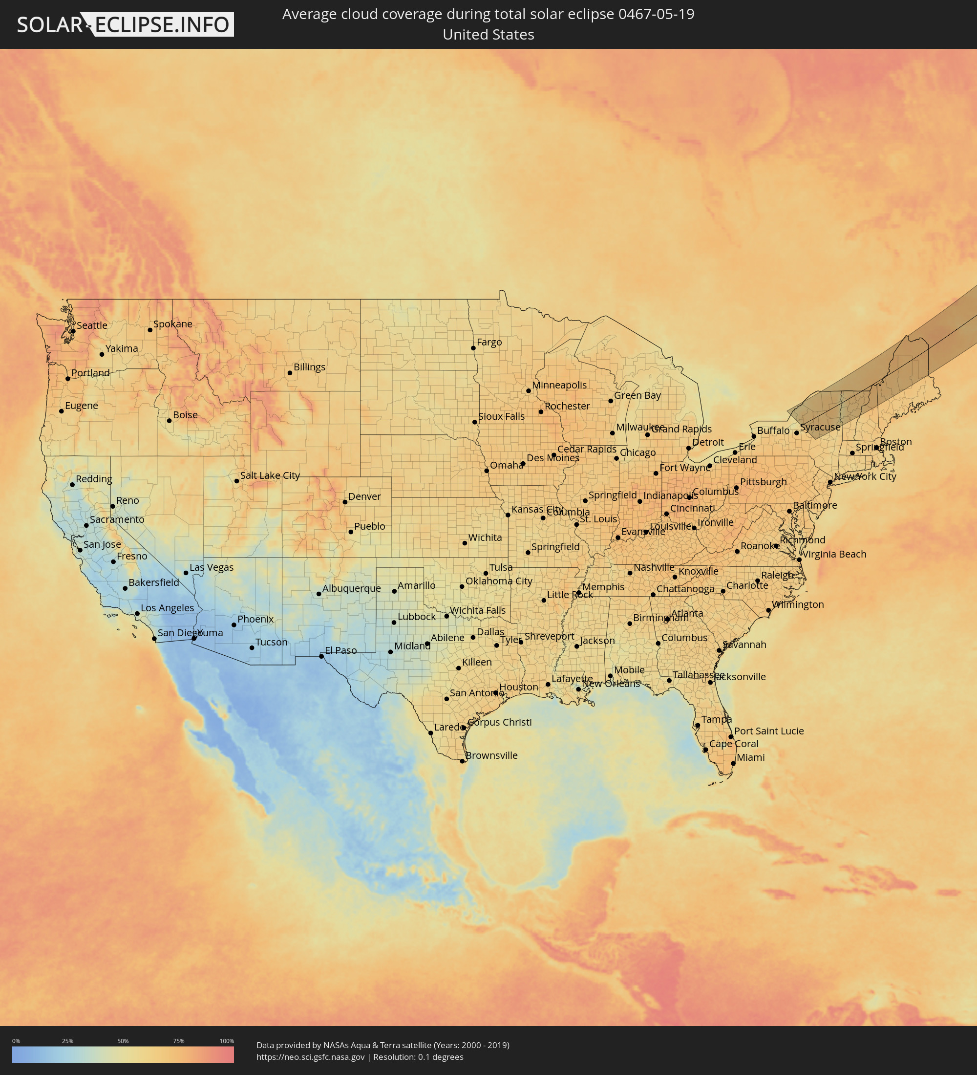 Vereinigte Staaten
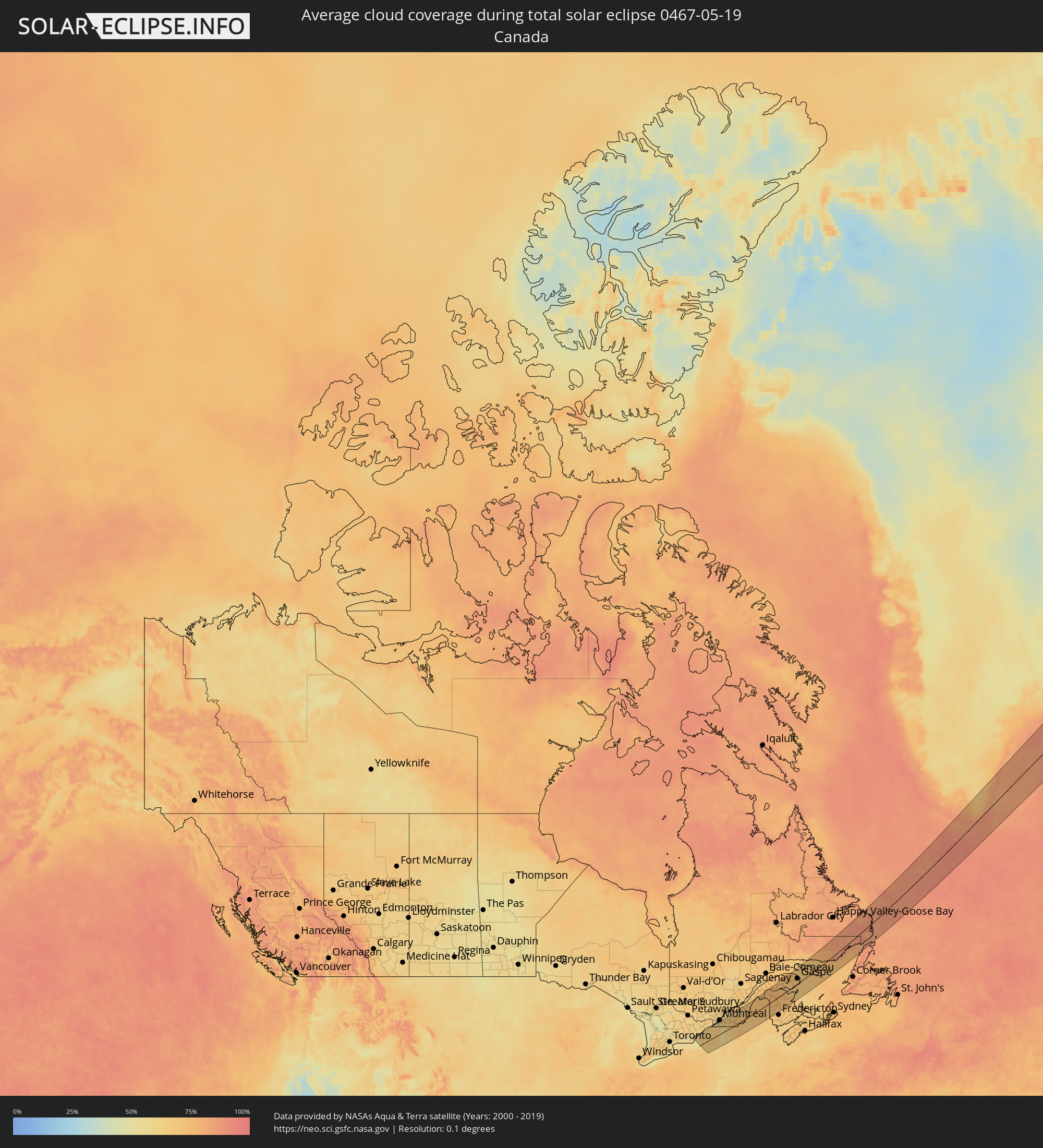 Kanada
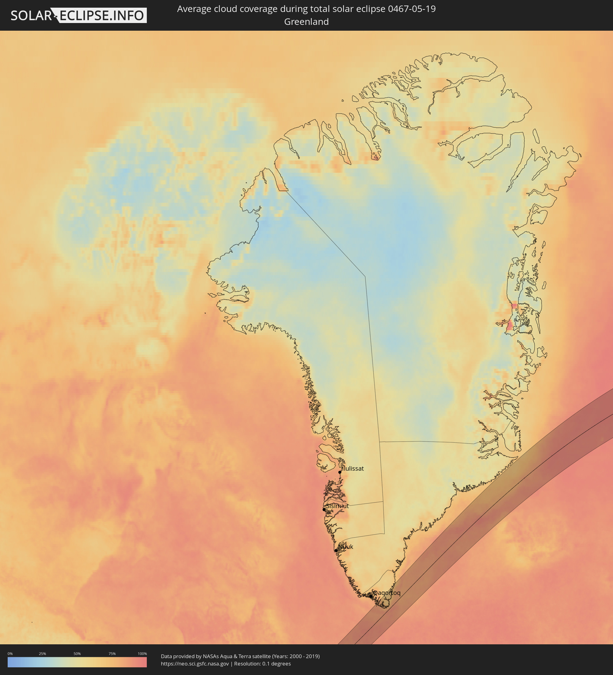 Grönland
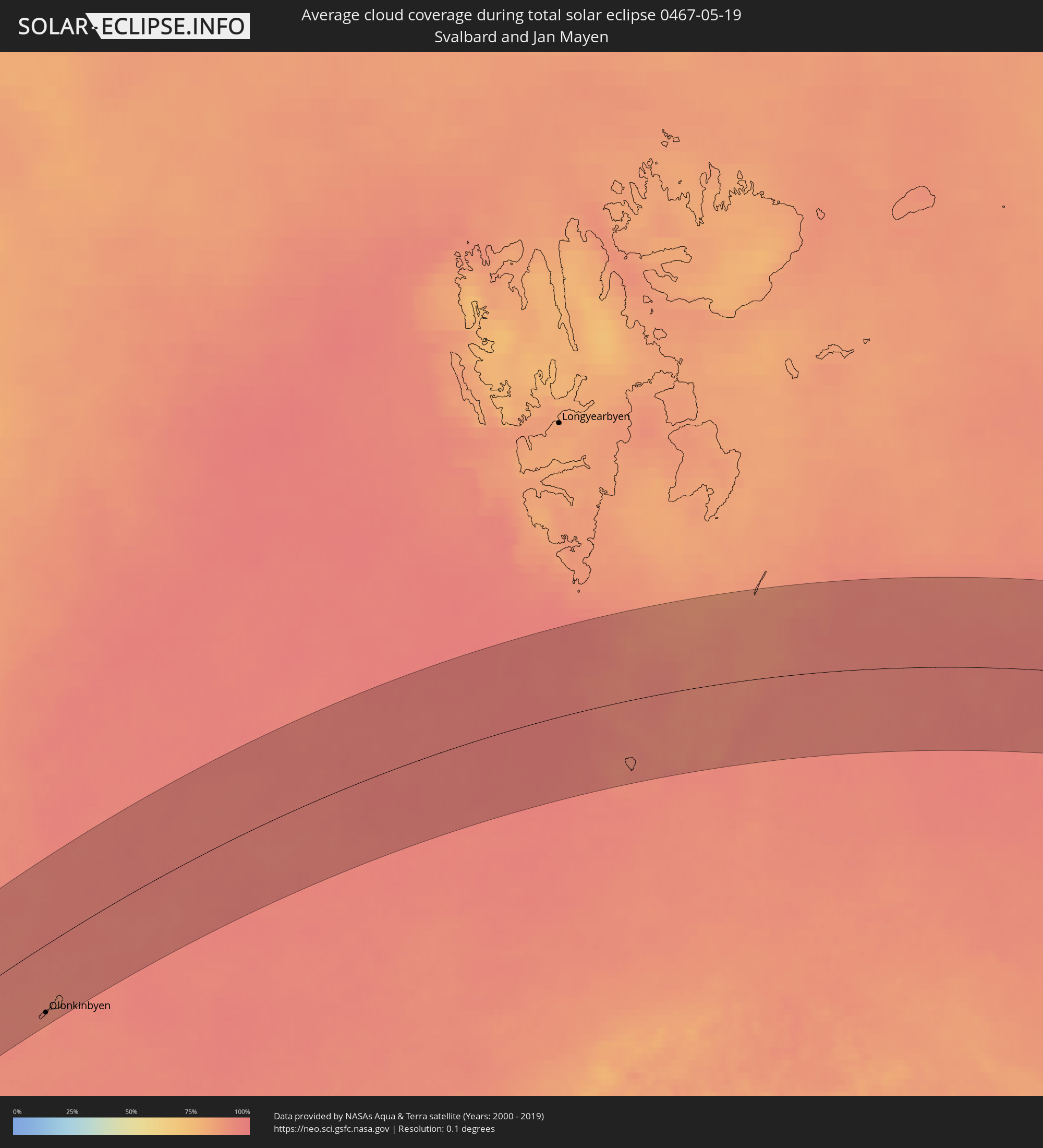 Spitzbergen
Orte im Finsternispfad
Die nachfolgene Tabelle zeigt Städte und Orte mit mehr als 5.000 Einwohnern, die sich im Finsternispfad befinden. Städte mit mehr als 100.000 Einwohnern sind dick gekennzeichnet. Mit einem Klick auf den Ort öffnet sich eine Detailkarte die die Lage des jeweiligen Ortes zusammen mit dem Verlauf der zentralen Finsternis präsentiert.
| Ort | Typ | Dauer der Verfinsterung | Ortszeit bei maximaler Verfinsterung | Entfernung zur Zentrallinie | Ø Bewölkung |
|
Kingston, Ontario
|
total | - | 04:38:25 UTC-05:00 | 101 km | 57% |
|
Gananoque, Ontario
|
total | - | 04:38:24 UTC-05:00 | 99 km | 55% |
|
Watertown, New York
|
total | - | 04:37:50 UTC-05:00 | 54 km | 63% |
|
Fort Drum, New York
|
total | - | 04:37:52 UTC-05:00 | 57 km | 66% |
|
Rome, New York
|
total | - | 04:36:40 UTC-05:00 | 42 km | 65% |
|
Utica, New York
|
total | - | 04:36:25 UTC-05:00 | 58 km | 64% |
|
Canton, New York
|
total | - | 04:38:16 UTC-05:00 | 86 km | 63% |
|
Ilion, New York
|
total | - | 04:36:13 UTC-05:00 | 74 km | 65% |
|
Herkimer, New York
|
total | - | 04:36:13 UTC-05:00 | 75 km | 65% |
|
Potsdam, New York
|
total | - | 04:38:17 UTC-05:00 | 85 km | 64% |
|
Gloversville, New York
|
total | - | 04:35:57 UTC-05:00 | 97 km | 62% |
|
Malone, New York
|
total | - | 04:38:12 UTC-05:00 | 78 km | 67% |
|
Saranac Lake, New York
|
total | - | 04:37:28 UTC-05:00 | 19 km | 70% |
|
Mercier, Quebec
|
total | - | 04:38:35 UTC-05:00 | 100 km | 62% |
|
West Glens Falls, New York
|
total | - | 04:35:58 UTC-05:00 | 98 km | 63% |
|
Glens Falls North, New York
|
total | - | 04:36:00 UTC-05:00 | 95 km | 63% |
|
Glens Falls, New York
|
total | - | 04:35:57 UTC-05:00 | 101 km | 60% |
|
Saint-Constant, Quebec
|
total | - | 04:38:34 UTC-05:00 | 97 km | 58% |
|
Delson, Quebec
|
total | - | 04:38:33 UTC-05:00 | 96 km | 60% |
|
Candiac, Quebec
|
total | - | 04:38:34 UTC-05:00 | 97 km | 60% |
|
La Prairie, Quebec
|
total | - | 04:38:36 UTC-05:00 | 100 km | 60% |
|
Brossard, Quebec
|
total | - | 04:38:38 UTC-05:00 | 102 km | 59% |
|
Plattsburgh, New York
|
total | - | 04:37:39 UTC-05:00 | 28 km | 60% |
|
Carignan, Quebec
|
total | - | 04:38:34 UTC-05:00 | 94 km | 62% |
|
Saint-Basile-le-Grand, Quebec
|
total | - | 04:38:40 UTC-05:00 | 101 km | 62% |
|
Chambly, Quebec
|
total | - | 04:38:33 UTC-05:00 | 93 km | 62% |
|
Saint-Jean-sur-Richelieu, Quebec
|
total | - | 04:38:22 UTC-05:00 | 82 km | 65% |
|
Richelieu, Quebec
|
total | - | 04:38:32 UTC-05:00 | 91 km | 65% |
|
Otterburn Park, Quebec
|
total | - | 04:38:38 UTC-05:00 | 99 km | 63% |
|
Burlington, Vermont
|
total | - | 04:37:15 UTC-05:00 | 21 km | 54% |
|
Mont-Saint-Hilaire, Quebec
|
total | - | 04:38:40 UTC-05:00 | 101 km | 62% |
|
Beloeil, Quebec
|
total | - | 04:38:40 UTC-05:00 | 101 km | 62% |
|
Winooski, Vermont
|
total | - | 04:37:16 UTC-05:00 | 19 km | 54% |
|
South Burlington, Vermont
|
total | - | 04:37:14 UTC-05:00 | 20 km | 54% |
|
Middlebury (village), Vermont
|
total | - | 04:36:39 UTC-05:00 | 49 km | 54% |
|
Marieville, Quebec
|
total | - | 04:38:29 UTC-05:00 | 87 km | 65% |
|
Colchester, Vermont
|
total | - | 04:37:19 UTC-05:00 | 13 km | 57% |
|
Essex Junction, Vermont
|
total | - | 04:37:14 UTC-05:00 | 14 km | 57% |
|
Saint Albans, Vermont
|
total | - | 04:37:38 UTC-05:00 | 25 km | 61% |
|
Williston, Vermont
|
total | - | 04:37:09 UTC-05:00 | 18 km | 56% |
|
Farnham, Quebec
|
total | - | 04:38:13 UTC-05:00 | 65 km | 68% |
|
Rutland, Vermont
|
total | - | 04:36:02 UTC-05:00 | 96 km | 61% |
|
Saint-Hyacinthe, Quebec
|
total | - | 04:38:40 UTC-05:00 | 98 km | 64% |
|
Saint-Pie, Quebec
|
total | - | 04:38:28 UTC-05:00 | 83 km | 65% |
|
Cowansville, Quebec
|
total | - | 04:38:00 UTC-05:00 | 48 km | 66% |
|
Granby, Quebec
|
total | - | 04:38:16 UTC-05:00 | 67 km | 66% |
|
Bromont, Quebec
|
total | - | 04:38:07 UTC-05:00 | 55 km | 67% |
|
Morristown, Vermont
|
total | - | 04:37:07 UTC-05:00 | 19 km | 66% |
|
Montpelier, Vermont
|
total | - | 04:36:42 UTC-05:00 | 50 km | 64% |
|
Acton Vale, Quebec
|
total | - | 04:38:32 UTC-05:00 | 84 km | 65% |
|
Lac-Brome, Quebec
|
total | - | 04:37:56 UTC-05:00 | 40 km | 67% |
|
Barre, Vermont
|
total | - | 04:36:36 UTC-05:00 | 59 km | 63% |
|
Drummondville, Quebec
|
total | - | 04:38:48 UTC-05:00 | 104 km | 63% |
|
Magog, Quebec
|
total | - | 04:37:51 UTC-05:00 | 31 km | 67% |
|
St Johnsbury, Vermont
|
total | - | 04:36:41 UTC-05:00 | 56 km | 65% |
|
Saint Johnsbury, Vermont
|
total | - | 04:36:41 UTC-05:00 | 56 km | 65% |
|
Lyndon, Vermont
|
total | - | 04:36:48 UTC-05:00 | 47 km | 66% |
|
Windsor, Quebec
|
total | - | 04:38:11 UTC-05:00 | 54 km | 68% |
|
Rock Forest, Quebec
|
total | - | 04:37:55 UTC-05:00 | 38 km | 69% |
|
Victoriaville, Quebec
|
total | - | 04:38:49 UTC-05:00 | 99 km | 67% |
|
Asbestos, Quebec
|
total | - | 04:38:26 UTC-05:00 | 69 km | 67% |
|
Sherbrooke, Quebec
|
total | - | 04:37:56 UTC-05:00 | 37 km | 69% |
|
Princeville, Quebec
|
total | - | 04:38:57 UTC-05:00 | 106 km | 67% |
|
Coaticook, Quebec
|
total | - | 04:37:32 UTC-05:00 | 21 km | 69% |
|
Plessisville, Quebec
|
total | - | 04:38:58 UTC-05:00 | 105 km | 66% |
|
Thetford-Mines, Quebec
|
total | - | 04:38:38 UTC-05:00 | 77 km | 67% |
|
Berlin, New Hampshire
|
total | - | 04:36:25 UTC-05:00 | 88 km | 71% |
|
Sainte-Marie, Quebec
|
total | - | 04:38:59 UTC-05:00 | 95 km | 69% |
|
Beauceville, Quebec
|
total | - | 04:38:36 UTC-05:00 | 66 km | 69% |
|
Saint-Georges, Quebec
|
total | - | 04:38:25 UTC-05:00 | 52 km | 70% |
|
Edmundston, New Brunswick
|
total | - | 05:24:58 UTC-04:14 | 71 km | 73% |
|
Presque Isle, Maine
|
total | - | 04:38:17 UTC-05:00 | 10 km | 76% |
|
Caribou, Maine
|
total | - | 04:38:33 UTC-05:00 | 10 km | 74% |
|
Campbellton, New Brunswick
|
total | - | 05:25:23 UTC-04:14 | 61 km | 74% |
|
Bathurst, New Brunswick
|
total | - | 05:24:32 UTC-04:14 | 28 km | 70% |
|
Miramichi, New Brunswick
|
total | - | 05:23:38 UTC-04:14 | 84 km | 72% |
|
Chandler, Quebec
|
total | - | 04:39:45 UTC-05:00 | 15 km | 71% |
|
Gaspé, Quebec
|
total | - | 04:40:26 UTC-05:00 | 40 km | 71% |
|
Olonkinbyen, Jan Mayen
|
total | - | 11:33:12 UTC+01:00 | 97 km | 91% |
|
Dudinka, Krasnoyarskiy
|
total | - | 17:38:47 UTC+06:11 | 69 km | 79% |
|
Kayyerkan, Krasnoyarskiy
|
total | - | 17:39:02 UTC+06:11 | 37 km | 80% |
|
Norilsk, Krasnoyarskiy
|
total | - | 17:39:08 UTC+06:11 | 27 km | 78% |
|
Talnakh, Krasnoyarskiy
|
total | - | 17:38:56 UTC+06:11 | 11 km | 74% |
|
Lensk, Sakha
|
total | - | 20:18:07 UTC+08:38 | 31 km | 76% |
|
Neryungri, Sakha
|
total | - | 20:19:34 UTC+08:38 | 41 km | 82% |
|
Chul’man, Sakha
|
total | - | 20:19:14 UTC+08:38 | 67 km | 83% |