Totale Sonnenfinsternis vom 02.08.0612
| Wochentag: | Sonntag |
| Maximale Dauer der Verfinsterung: | 04m35s |
| Maximale Breite des Finsternispfades: | 280 km |
| Saroszyklus: | 84 |
| Bedeckungsgrad: | 100% |
| Magnitude: | 1.0679 |
| Gamma: | 0.6163 |
Wo kann man die Sonnenfinsternis vom 02.08.0612 sehen?
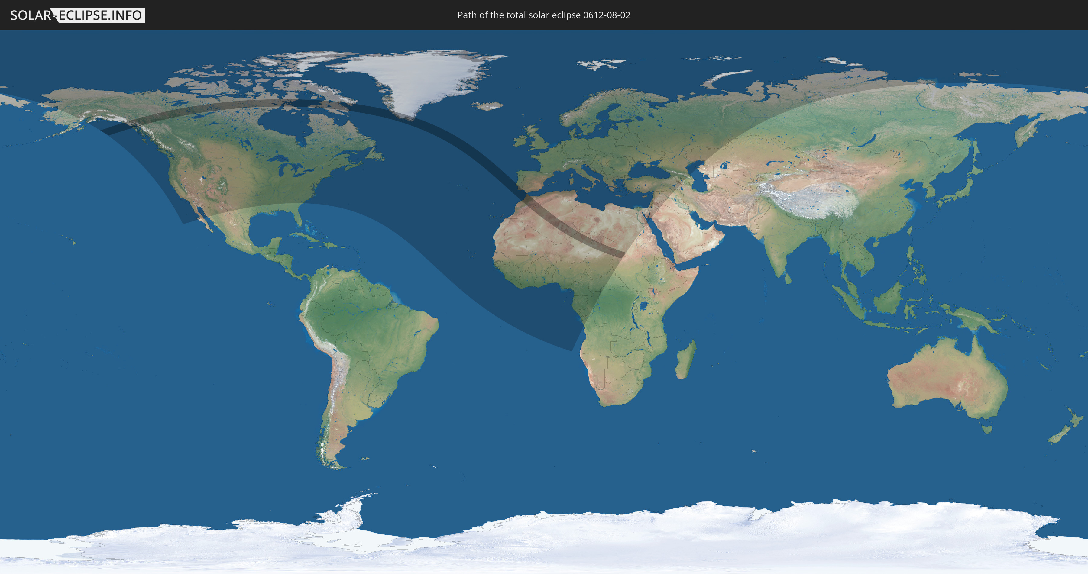
Die Sonnenfinsternis am 02.08.0612 kann man in 102 Ländern als partielle Sonnenfinsternis beobachten.
Der Finsternispfad verläuft durch 10 Länder. Nur in diesen Ländern ist sie als totale Sonnenfinsternis zu sehen.
In den folgenden Ländern ist die Sonnenfinsternis total zu sehen
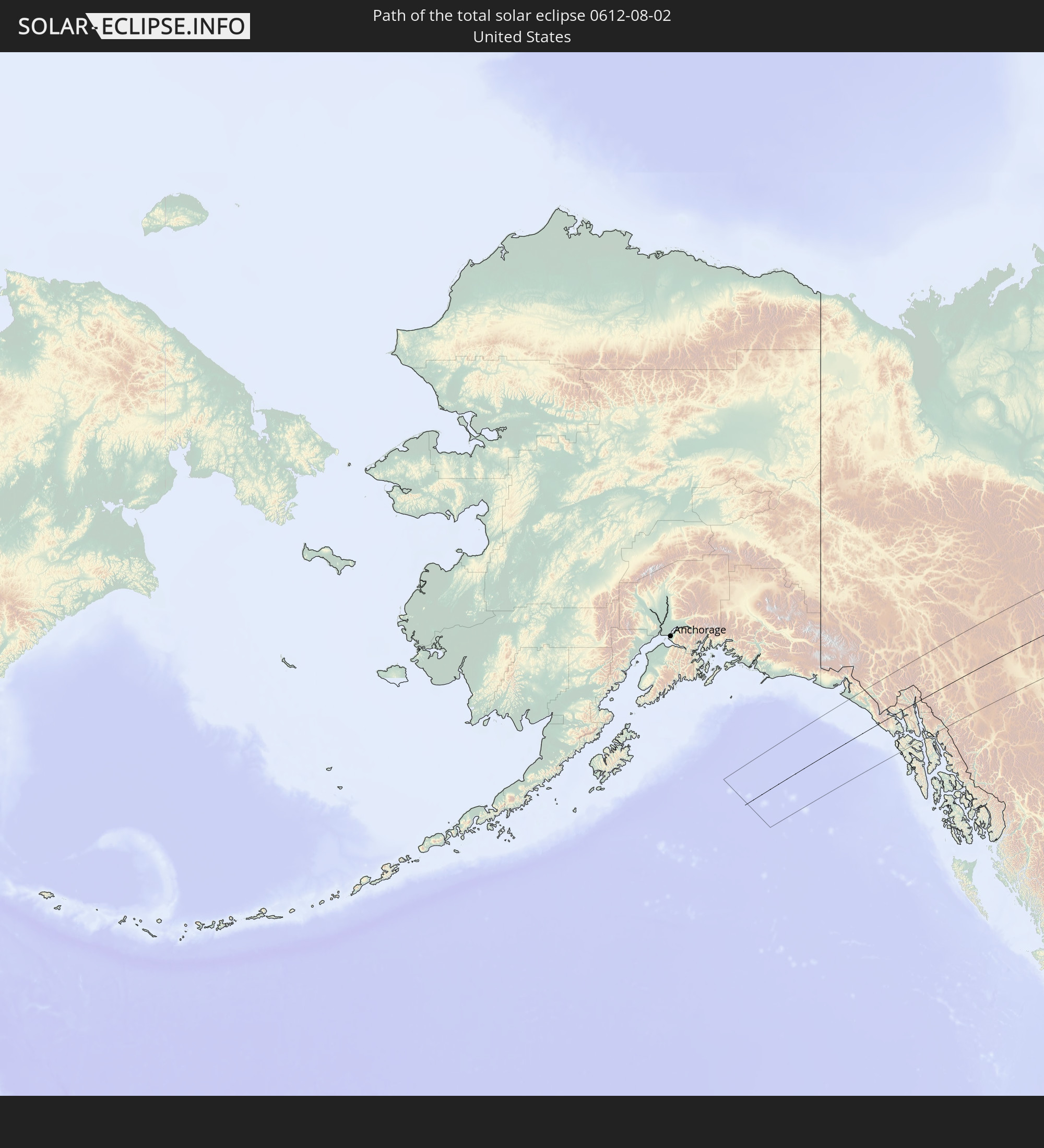 Vereinigte Staaten
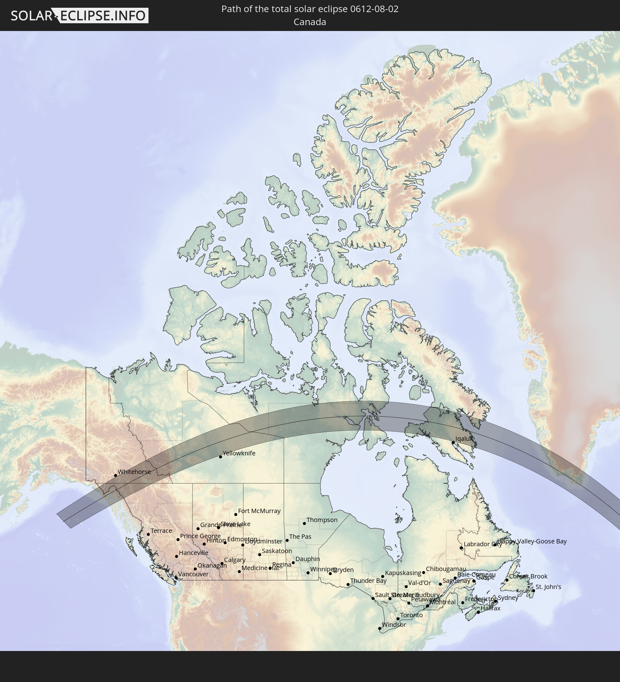 Kanada
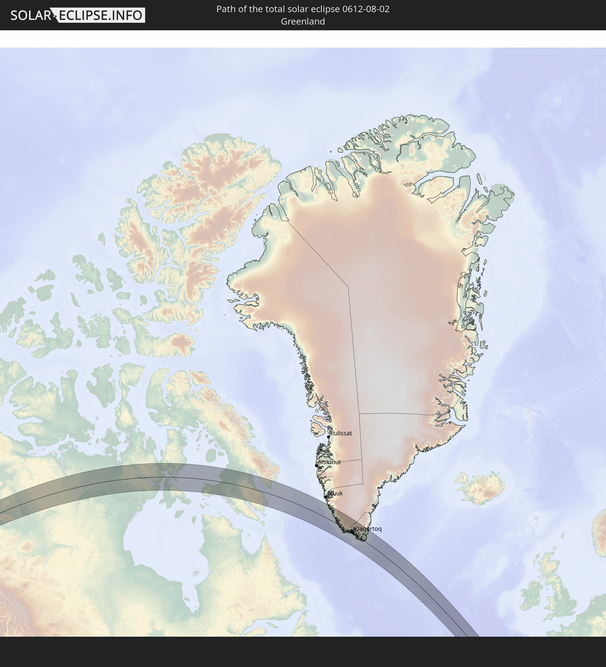 Grönland
 Portugal
 Spanien
 Marokko
 Algerien
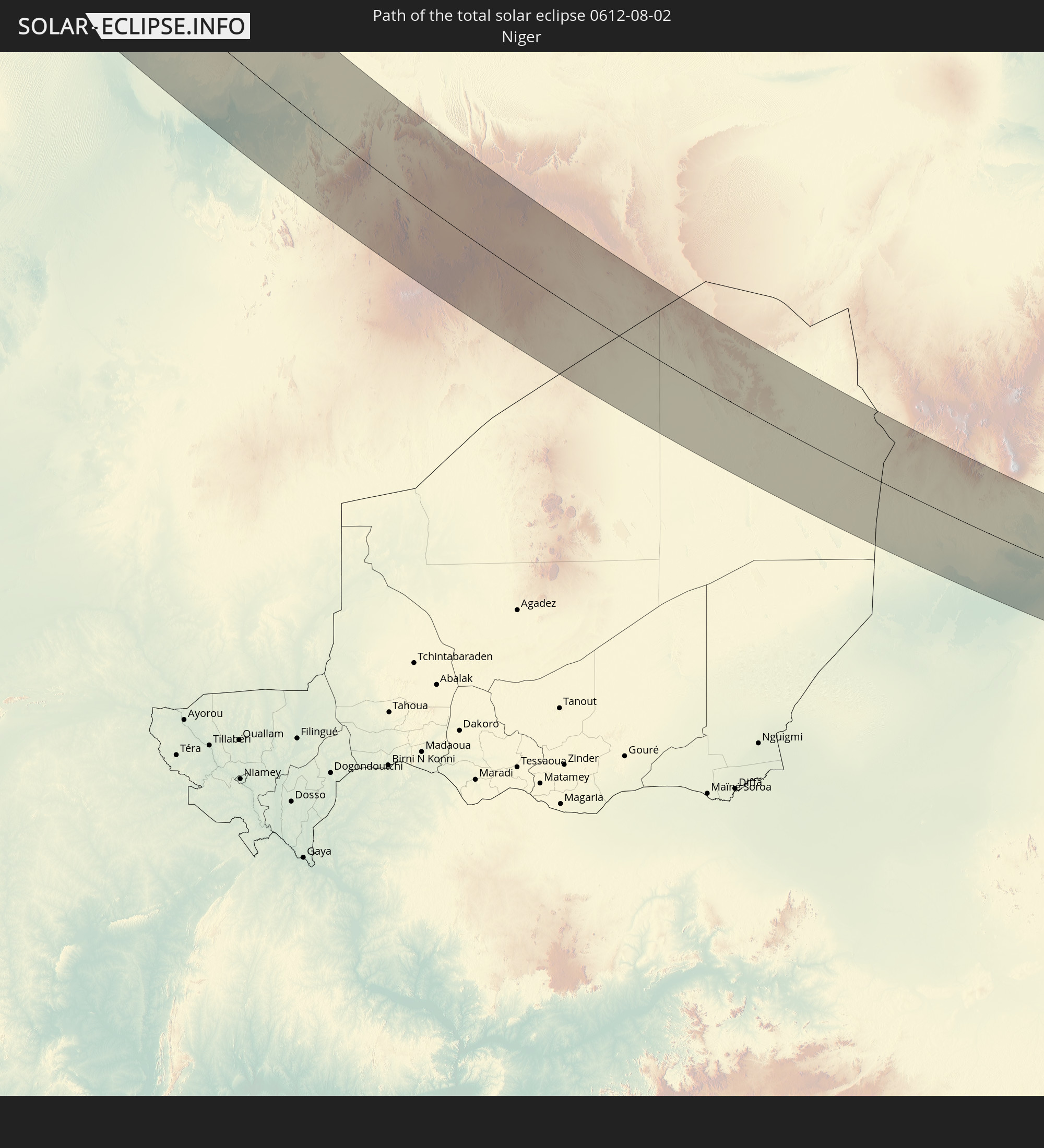 Niger
Niger
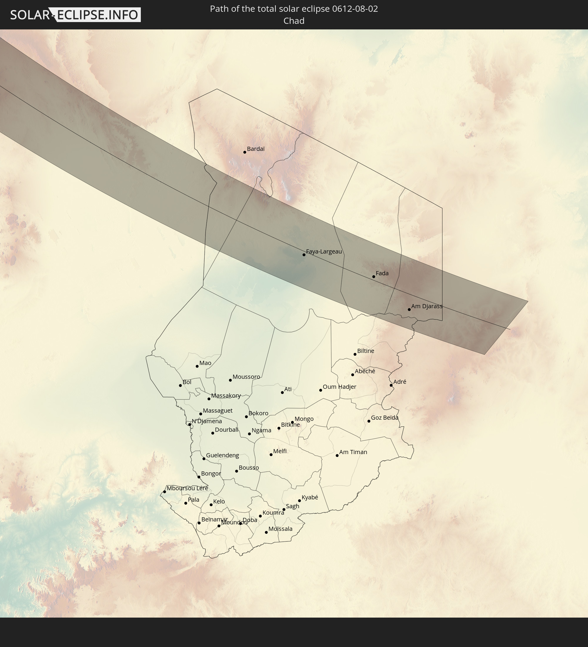 Tschad
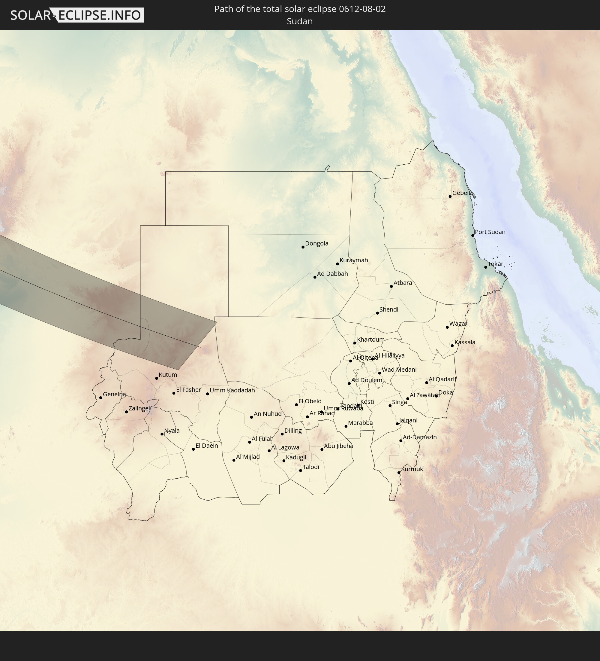 Sudan
Sudan
In den folgenden Ländern ist die Sonnenfinsternis partiell zu sehen
 Russland
 Vereinigte Staaten
 Kanada
 Mexiko
 Grönland
 Bermuda
 Saint-Pierre und Miquelon
 Portugal
 Kap Verde
 Island
 Spanien
 Senegal
 Mauretanien
 Gambia
 Guinea-Bissau
 Guinea
 Sierra Leone
 Marokko
 Mali
Mali
 Liberia
 Irland
 Spitzbergen
 Algerien
 Vereinigtes Königreich
 Elfenbeinküste
 Färöer
 Burkina Faso
 Gibraltar
 Frankreich
 Isle of Man
 Ghana
Ghana
 Guernsey
 Jersey
 Togo
Togo
 Niger
Niger
 Benin
Benin
 Andorra
 Belgien
 Nigeria
 Niederlande
 Norwegen
 Äquatorialguinea
 Luxemburg
 Deutschland
 Schweiz
 São Tomé und Príncipe
 Italien
 Monaco
 Tunesien
 Dänemark
 Kamerun
 Gabun
Gabun
 Libyen
 Liechtenstein
 Österreich
 Schweden
 Republik Kongo
 Angola
 Tschechien
 Demokratische Republik Kongo
 San Marino
 Vatikanstadt
 Slowenien
 Tschad
 Kroatien
 Polen
Polen
 Malta
Malta
 Zentralafrikanische Republik
 Bosnien und Herzegowina
 Ungarn
 Slowakei
 Montenegro
 Serbien
 Albanien
 Åland Islands
 Griechenland
 Rumänien
 Mazedonien
 Finnland
 Litauen
 Lettland
 Estland
 Sudan
Sudan
 Ukraine
 Bulgarien
 Weißrussland
 Ägypten
 Türkei
 Moldawien
 Republik Zypern
 Staat Palästina
 Israel
 Saudi-Arabien
 Jordanien
 Libanon
 Syrien
 Irak
Irak
 Georgien
 Armenien
 Iran
Iran
 Aserbaidschan
 Kasachstan
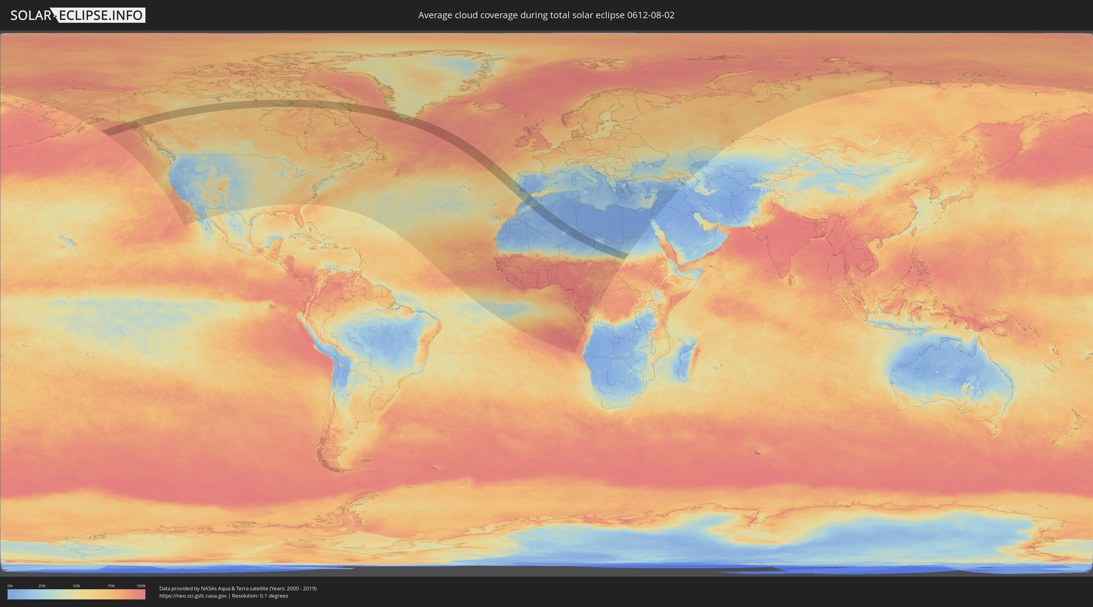
Wie wird das Wetter während der totalen Sonnenfinsternis am 02.08.0612?
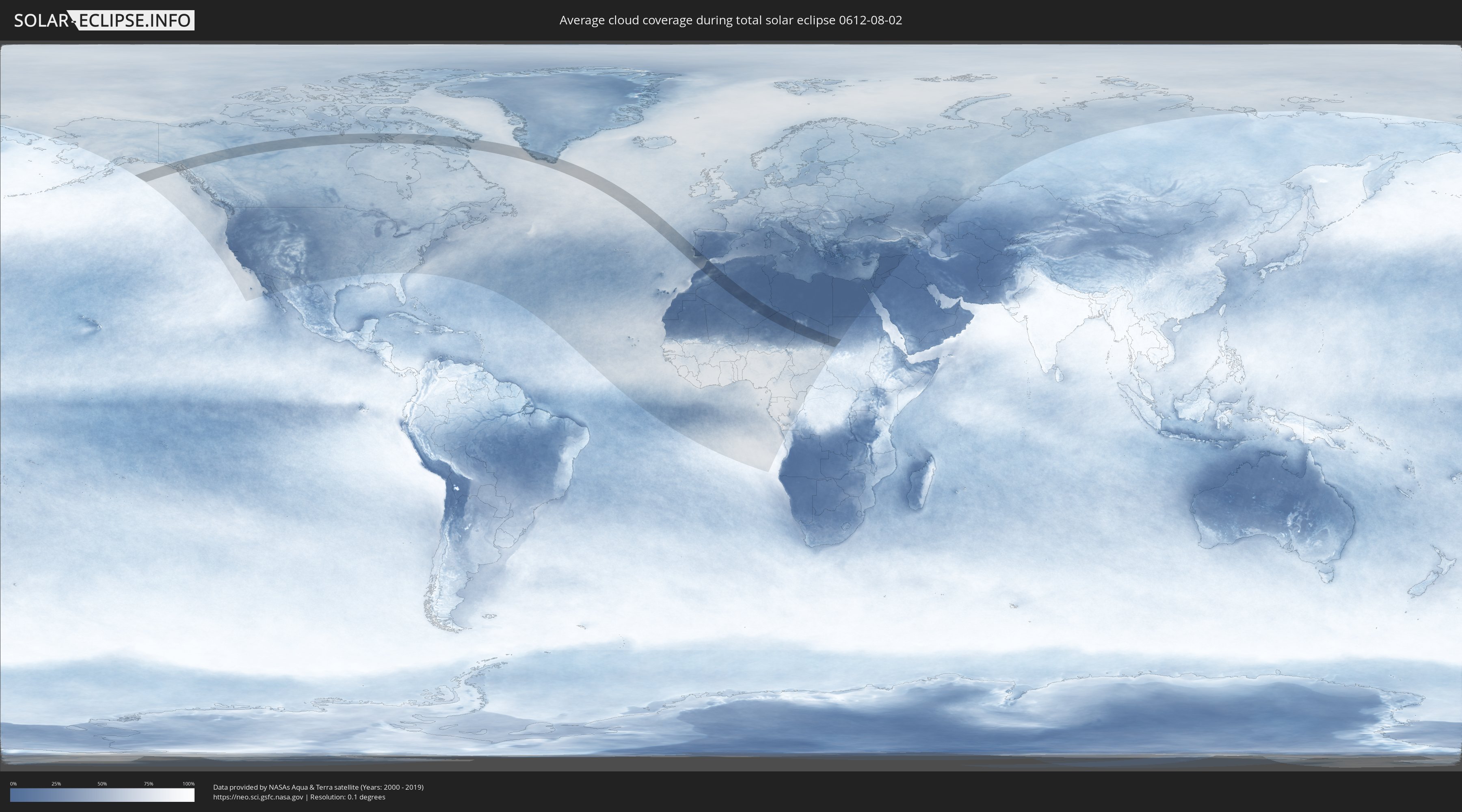
Wo ist der beste Ort, um die totale Sonnenfinsternis vom 02.08.0612 zu beobachten?
Die folgenden Karten zeigen die durchschnittliche Bewölkung für den Tag, an dem die totale Sonnenfinsternis
stattfindet. Mit Hilfe der Karten lässt sich der Ort entlang des Finsternispfades eingrenzen,
der die besten Aussichen auf einen klaren wolkenfreien Himmel bietet.
Trotzdem muss man immer lokale Gegenenheiten beachten und sollte sich genau über das Wetter an seinem
gewählten Beobachtungsort informieren.
Die Daten stammen von den beiden NASA-Satelliten
AQUA und TERRA
und wurden über einen Zeitraum von 19 Jahren (2000 - 2019) gemittelt.
Detaillierte Länderkarten
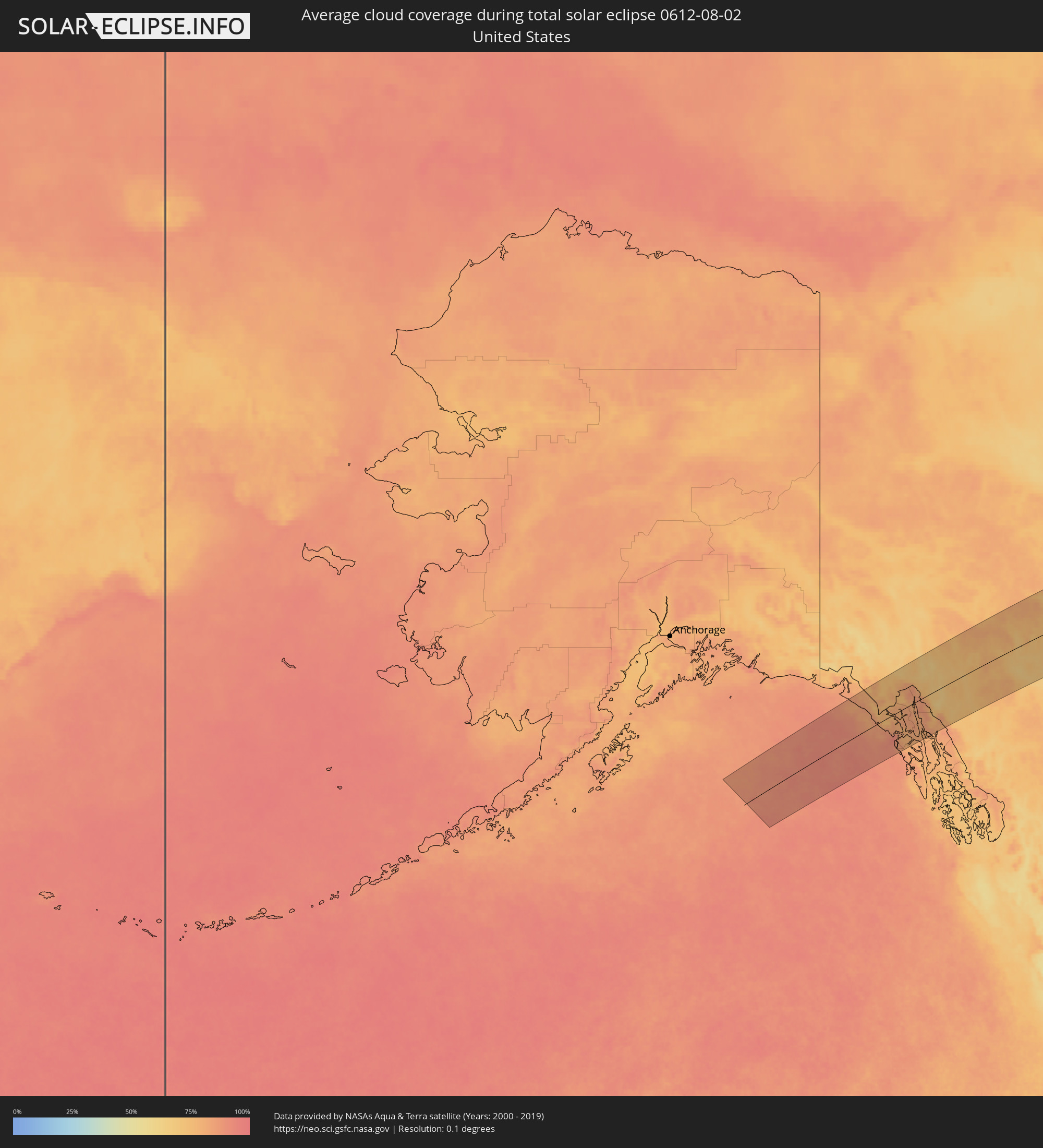 Vereinigte Staaten
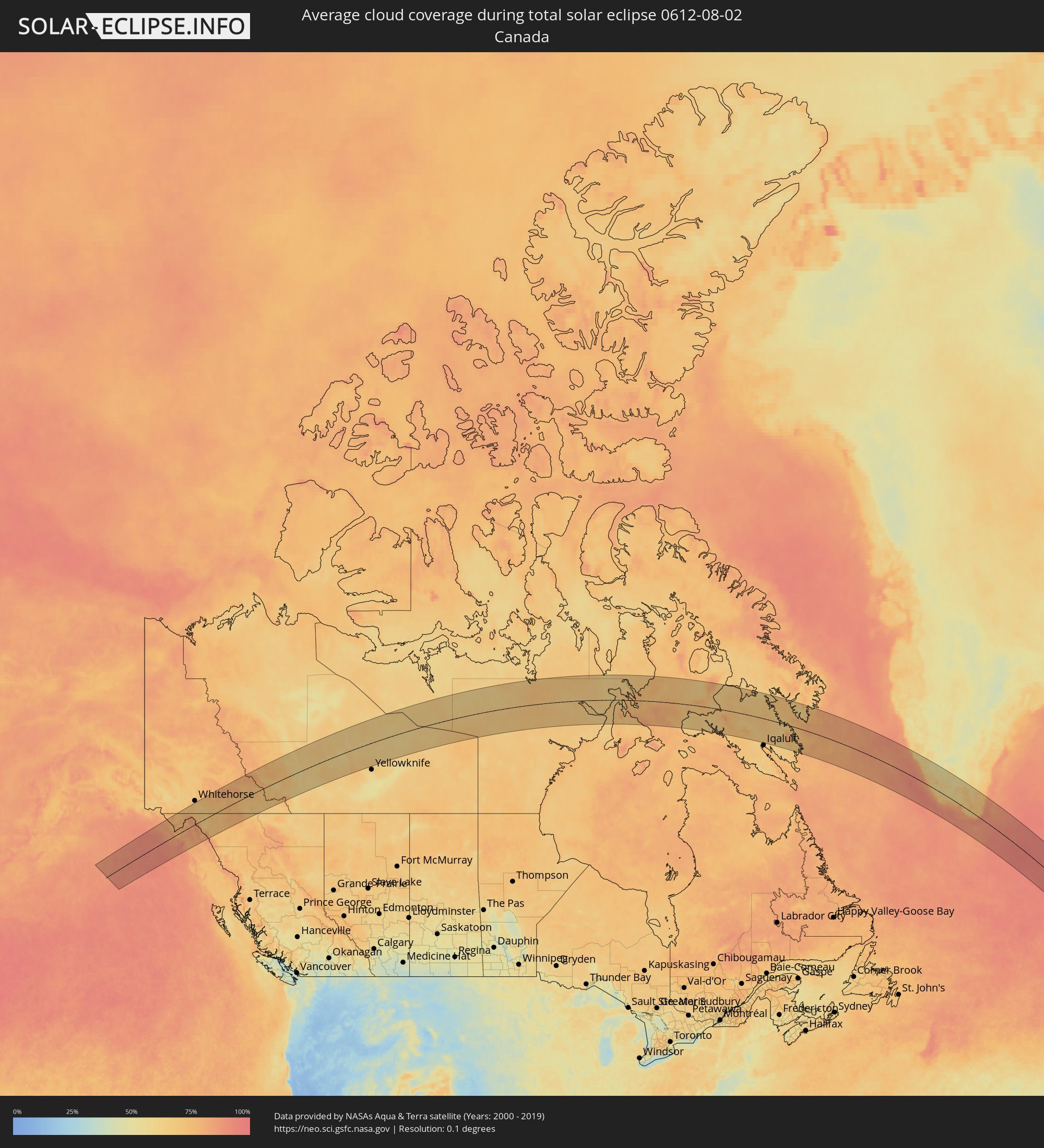 Kanada
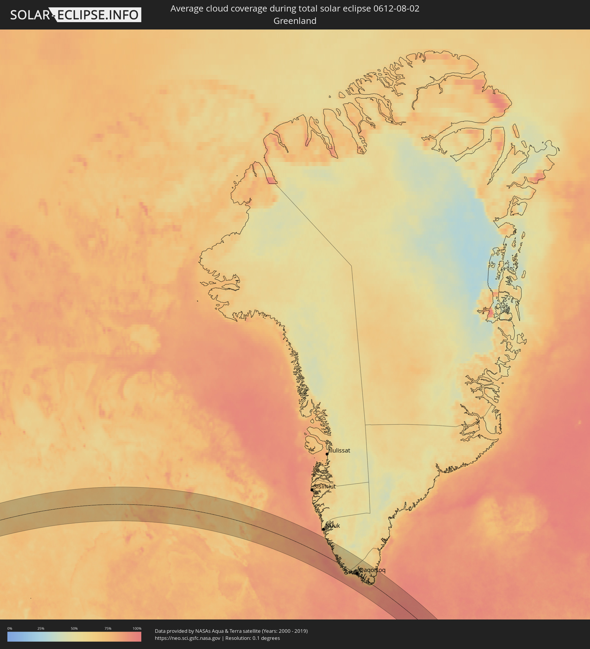 Grönland
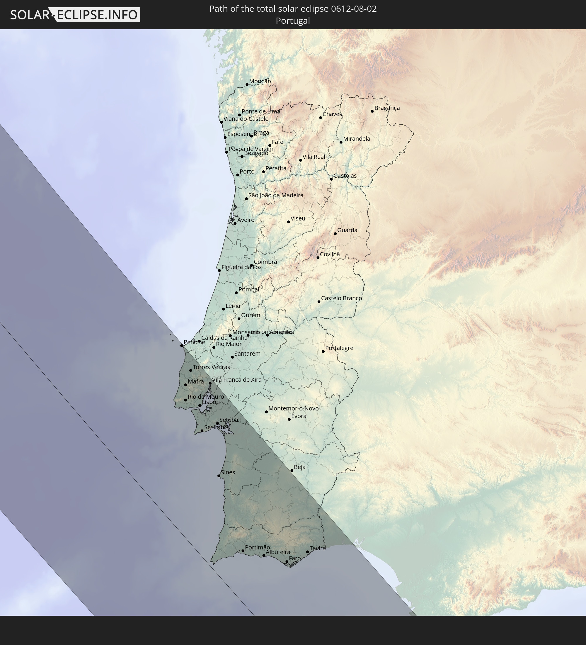
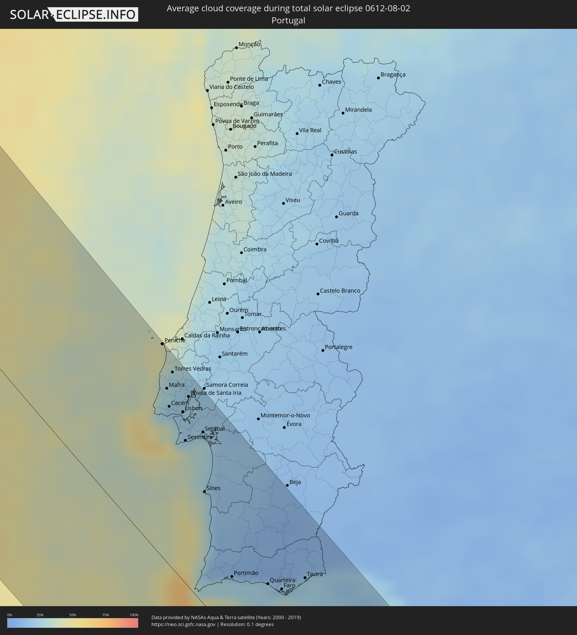 Portugal
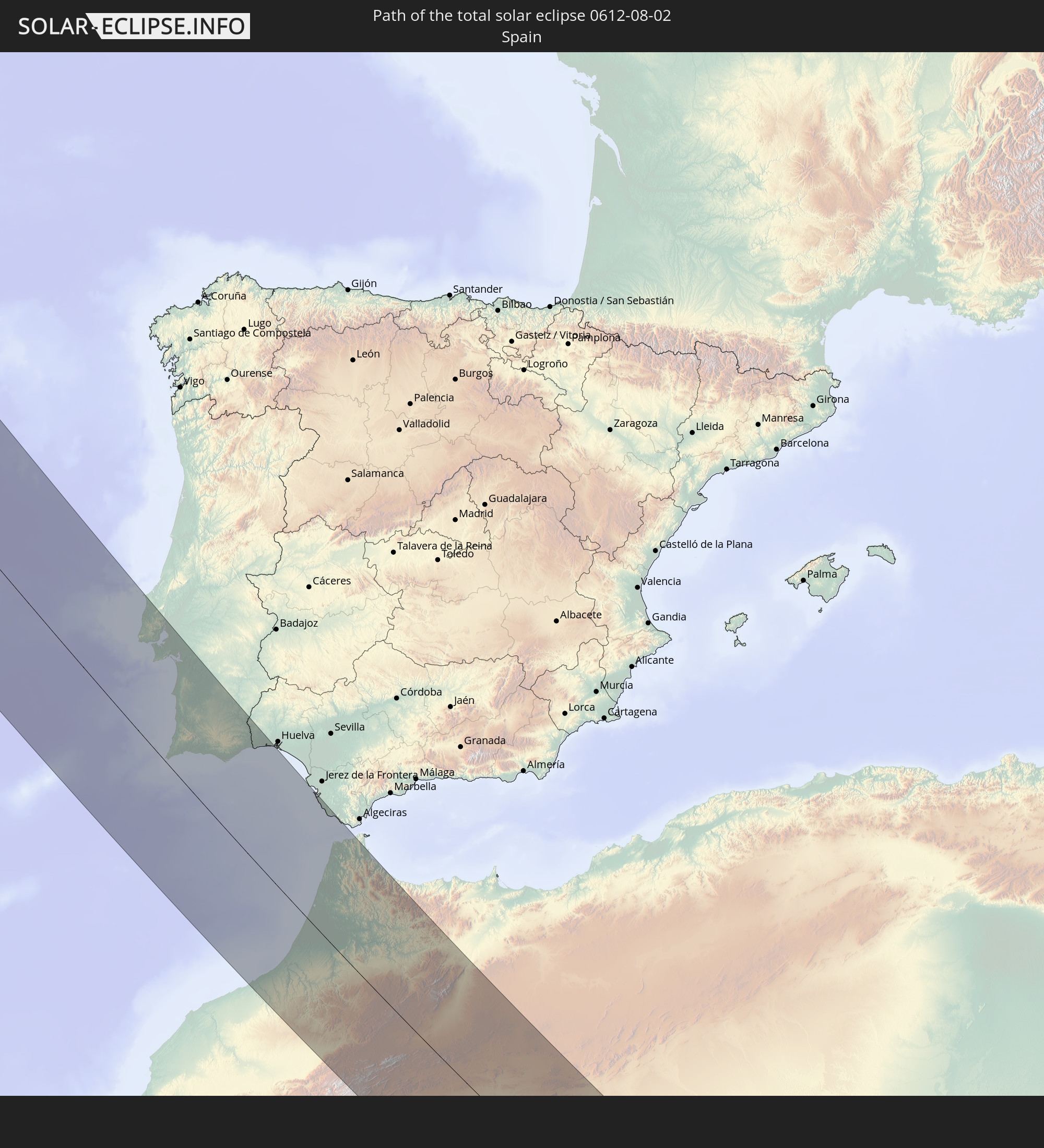
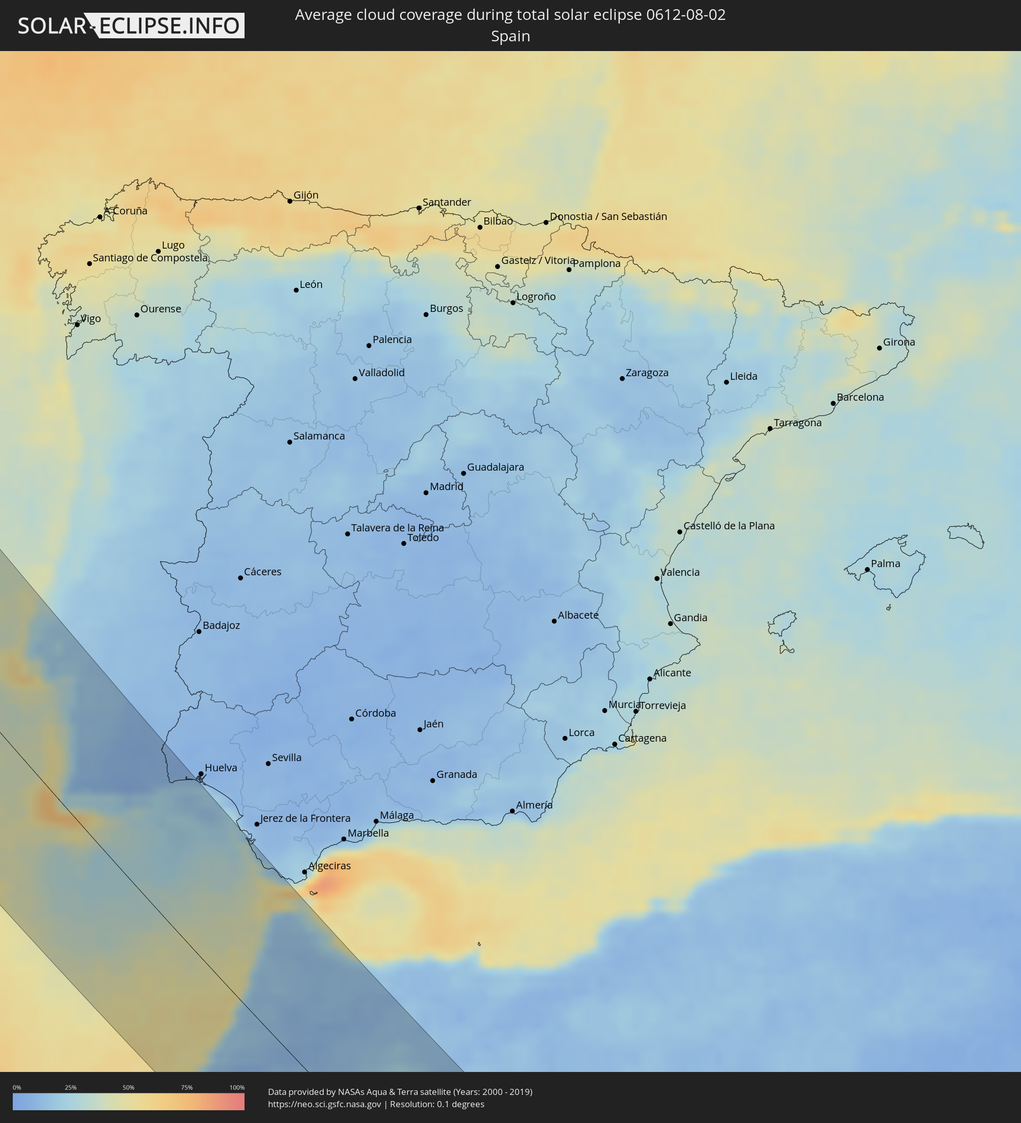 Spanien
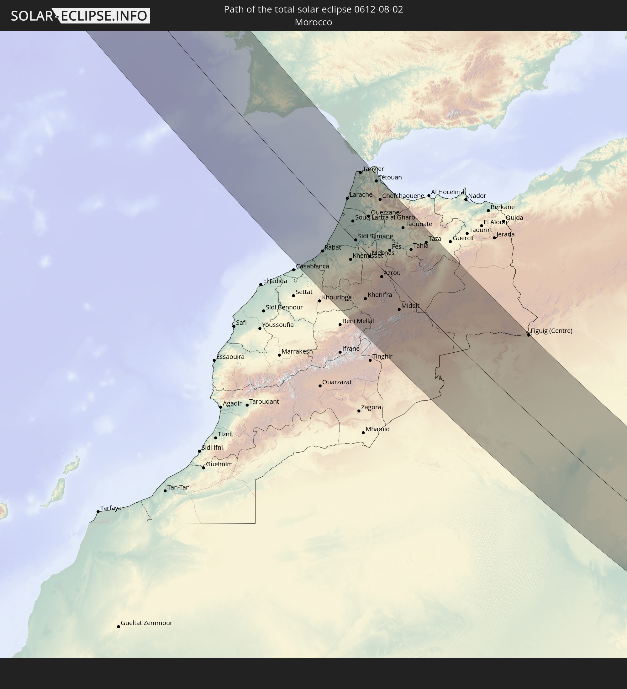
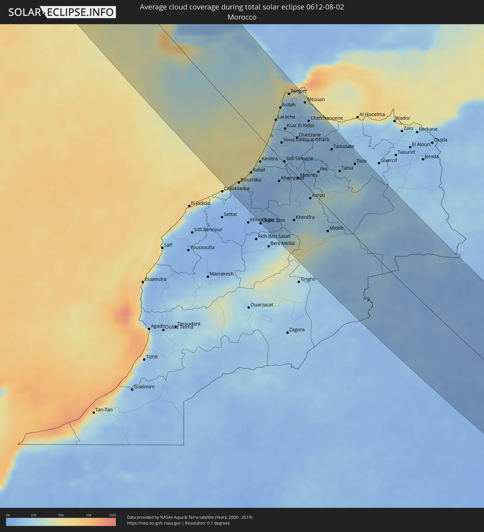 Marokko
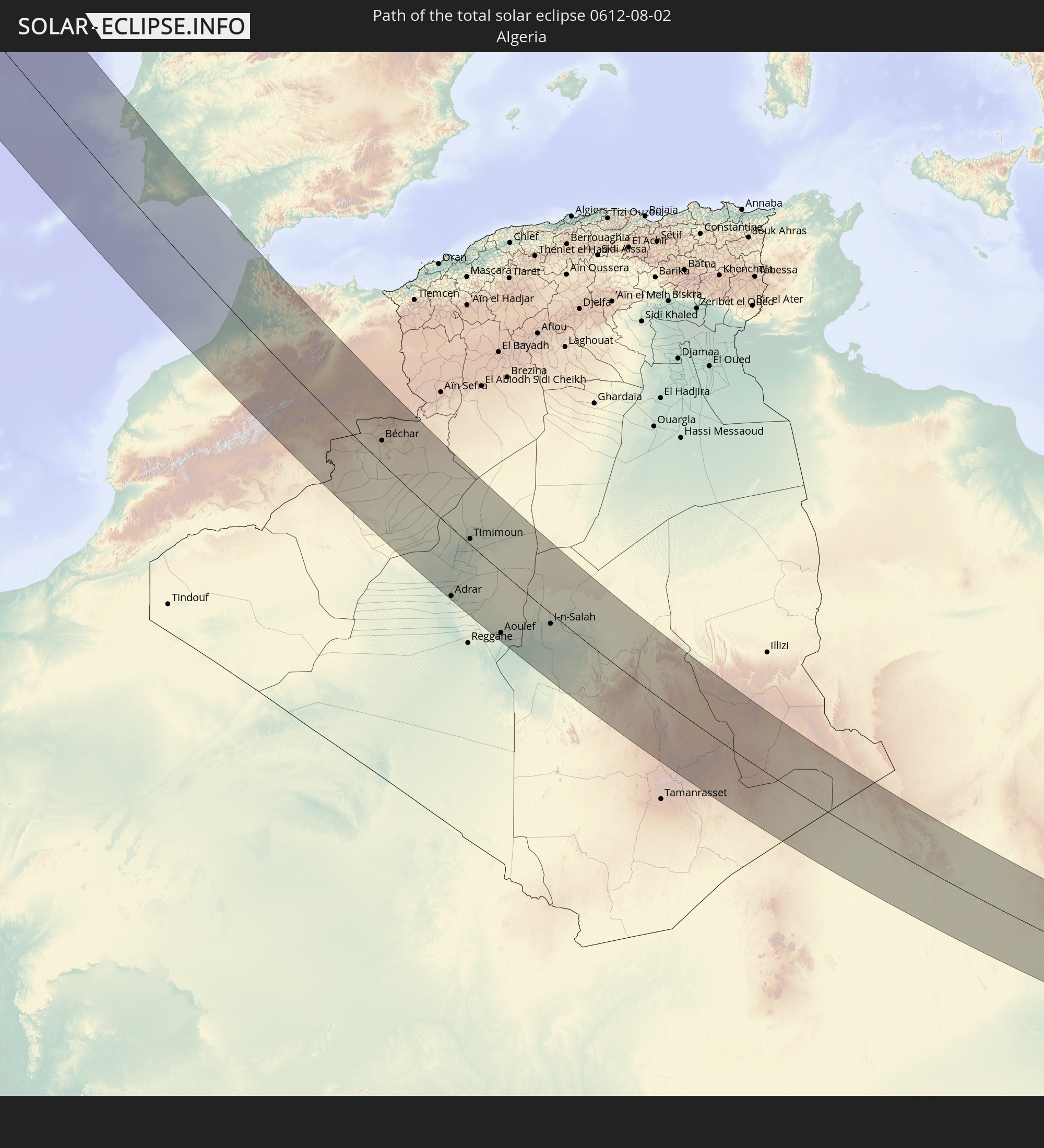
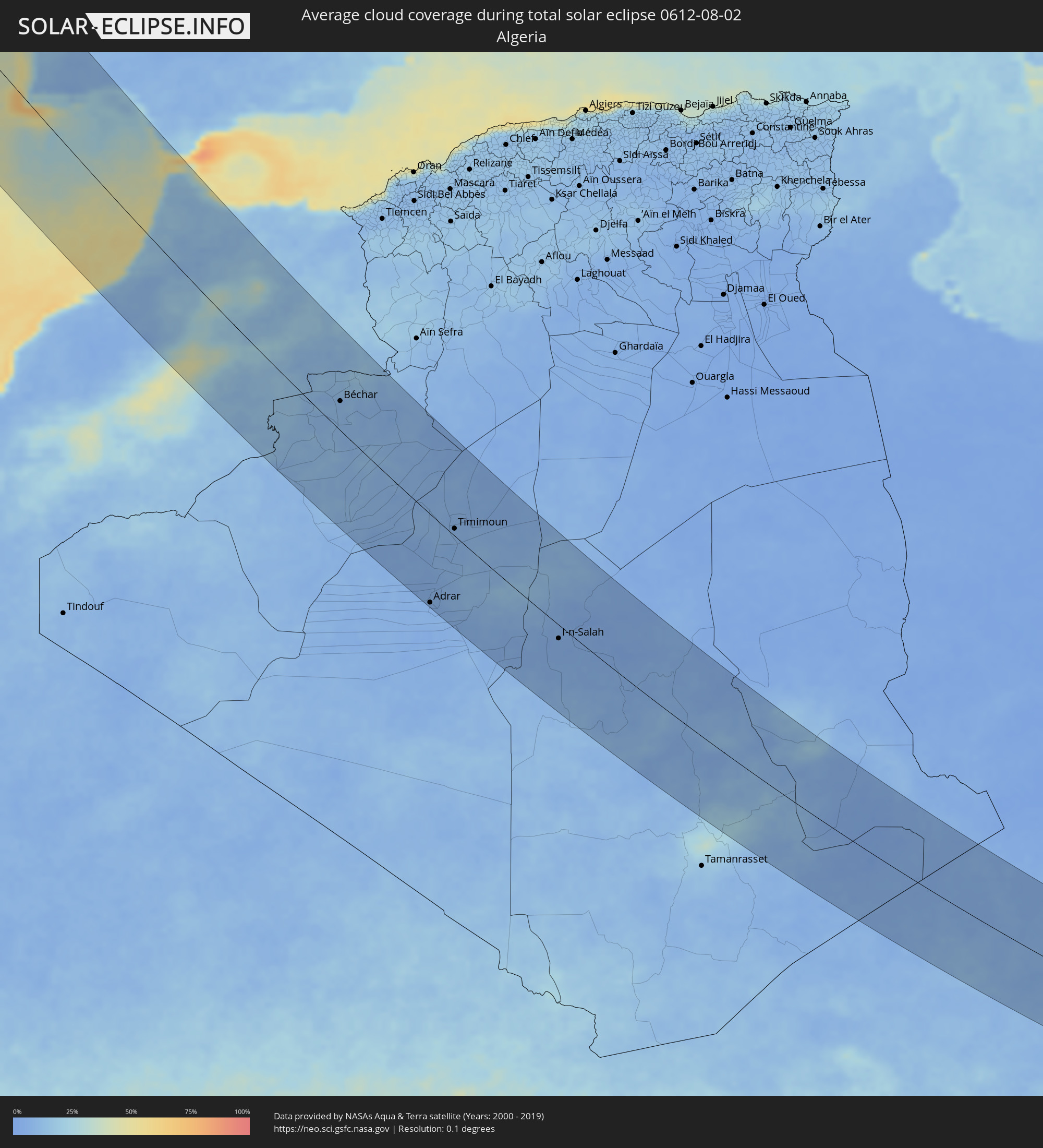 Algerien
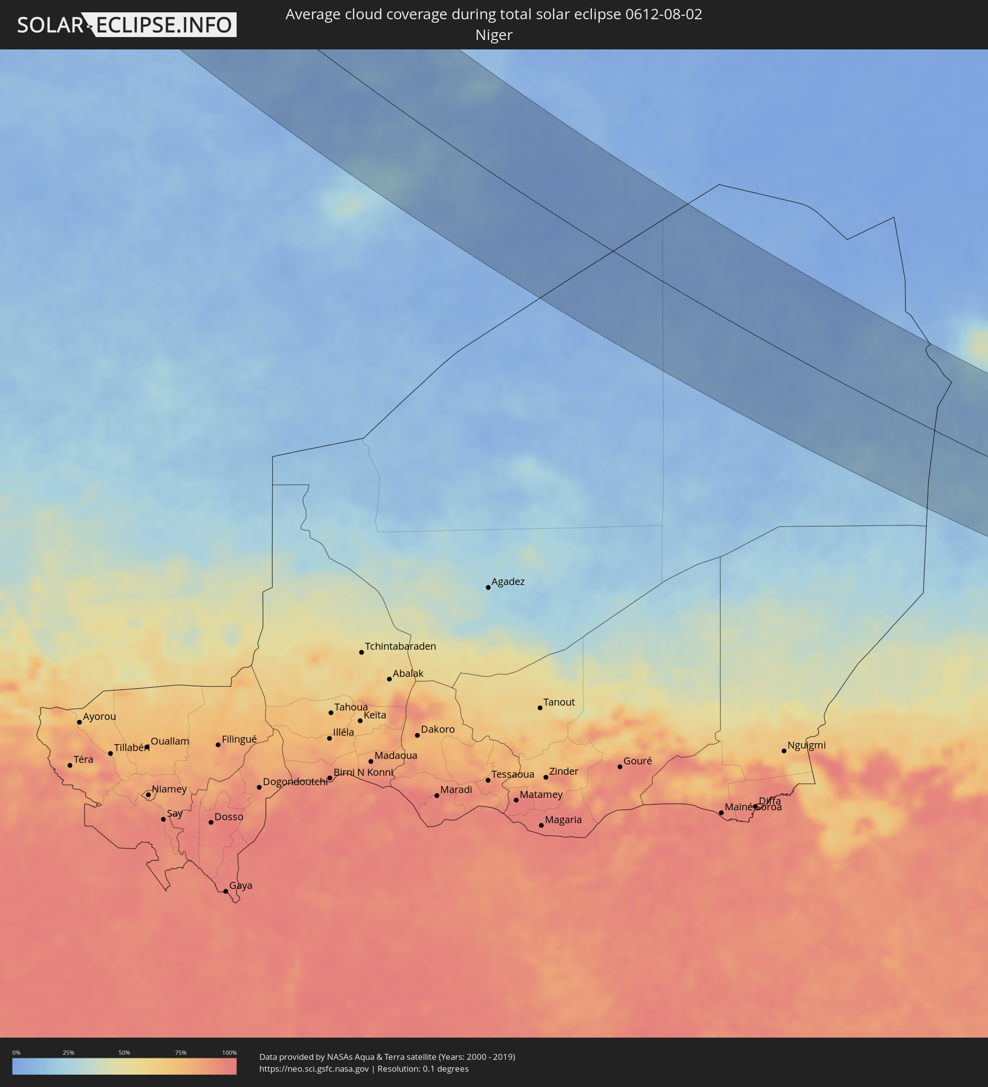 Niger
Niger
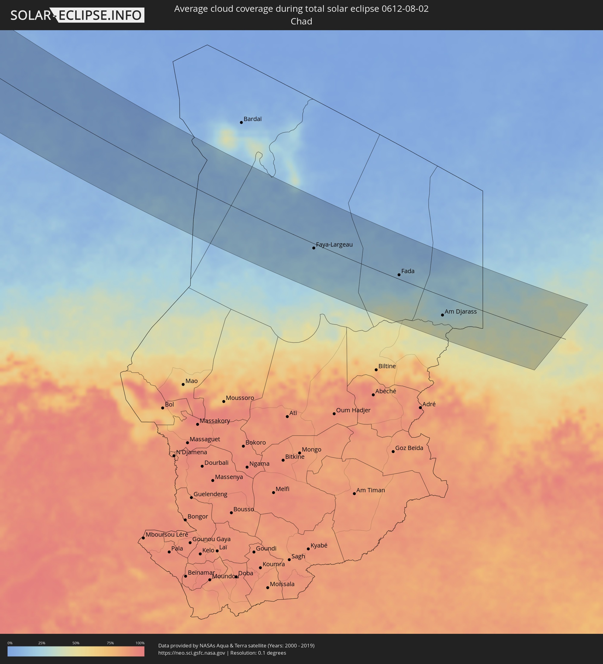 Tschad
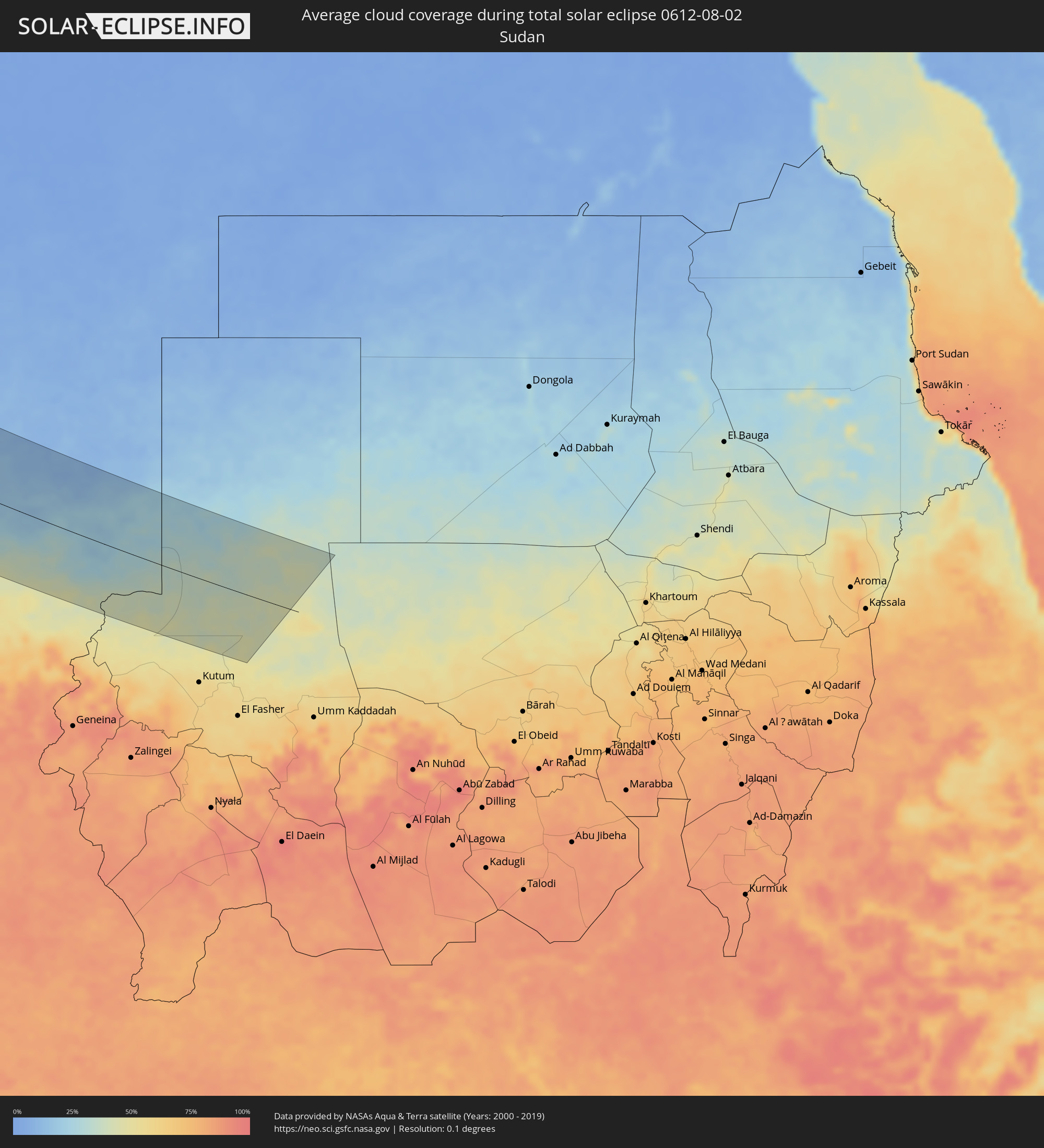 Sudan
Sudan
Orte im Finsternispfad
Die nachfolgene Tabelle zeigt Städte und Orte mit mehr als 5.000 Einwohnern, die sich im Finsternispfad befinden. Städte mit mehr als 100.000 Einwohnern sind dick gekennzeichnet. Mit einem Klick auf den Ort öffnet sich eine Detailkarte die die Lage des jeweiligen Ortes zusammen mit dem Verlauf der zentralen Finsternis präsentiert.
| Ort | Typ | Dauer der Verfinsterung | Ortszeit bei maximaler Verfinsterung | Entfernung zur Zentrallinie | Ø Bewölkung |
|
Juneau, Alaska
|
total | - | 03:55:26 UTC-10:00 | 119 km | 80% |
|
Qaqortoq, Kujalleq
|
total | - | 11:18:51 UTC-03:26 | 8 km | 66% |
|
Colares, Lisbon
|
total | - | 15:18:25 UTC-00:36 | 105 km | 25% |
|
Peniche, Leiria
|
total | - | 15:17:25 UTC-00:36 | 149 km | 44% |
|
Mafra, Lisbon
|
total | - | 15:18:15 UTC-00:36 | 122 km | 21% |
|
Cacém, Lisbon
|
total | - | 15:18:35 UTC-00:36 | 115 km | 20% |
|
Almargem, Lisbon
|
total | - | 15:18:27 UTC-00:36 | 120 km | 20% |
|
Quejas, Lisbon
|
total | - | 15:18:41 UTC-00:36 | 113 km | 29% |
|
Torres Vedras, Lisbon
|
total | - | 15:18:00 UTC-00:36 | 136 km | 27% |
|
Pragal, Setúbal
|
total | - | 15:18:51 UTC-00:36 | 114 km | 21% |
|
Lisbon, Lisbon
|
total | - | 15:18:48 UTC-00:36 | 119 km | 19% |
|
Sesimbra, Setúbal
|
total | - | 15:19:20 UTC-00:36 | 100 km | 38% |
|
Bobadela, Lisbon
|
total | - | 15:18:39 UTC-00:36 | 129 km | 21% |
|
Póvoa de Santa Iria, Lisbon
|
total | - | 15:18:35 UTC-00:36 | 136 km | 21% |
|
Castanheira do Ribatejo, Lisbon
|
total | - | 15:18:24 UTC-00:36 | 151 km | 19% |
|
Quinta do Anjo, Setúbal
|
total | - | 15:19:13 UTC-00:36 | 119 km | 21% |
|
Setúbal, Setúbal
|
total | - | 15:19:20 UTC-00:36 | 120 km | 30% |
|
Sines, Setúbal
|
total | - | 15:20:25 UTC-00:36 | 80 km | 30% |
|
Santo André, Setúbal
|
total | - | 15:20:19 UTC-00:36 | 95 km | 18% |
|
Santiago do Cacém, Setúbal
|
total | - | 15:20:25 UTC-00:36 | 96 km | 15% |
|
Grândola, Setúbal
|
total | - | 15:20:13 UTC-00:36 | 116 km | 17% |
|
Portimão, Faro
|
total | - | 15:22:10 UTC-00:36 | 45 km | 25% |
|
Alcácer do Sal, Setúbal
|
total | - | 15:19:53 UTC-00:36 | 136 km | 17% |
|
Estômbar, Faro
|
total | - | 15:22:12 UTC-00:36 | 49 km | 25% |
|
São Bartolomeu de Messines, Faro
|
total | - | 15:22:07 UTC-00:36 | 70 km | 8% |
|
Albufeira, Faro
|
total | - | 15:22:28 UTC-00:36 | 58 km | 24% |
|
Loulé, Faro
|
total | - | 15:22:32 UTC-00:36 | 77 km | 16% |
|
Faro, Faro
|
total | - | 15:22:49 UTC-00:36 | 74 km | 30% |
|
Moncarapacho, Faro
|
total | - | 15:22:47 UTC-00:36 | 89 km | 19% |
|
Tavira, Faro
|
total | - | 15:22:49 UTC-00:36 | 101 km | 23% |
|
Vila Real de Santo António, Faro
|
total | - | 15:22:51 UTC-00:36 | 121 km | 19% |
|
Ayamonte, Andalusia
|
total | - | 15:59:34 UTC+00:00 | 123 km | 19% |
|
Mohammedia, Grand Casablanca
|
total | - | 15:35:46 UTC-00:30 | 143 km | 22% |
|
Isla Cristina, Andalusia
|
total | - | 15:59:39 UTC+00:00 | 128 km | 20% |
|
Lepe, Andalusia
|
total | - | 15:59:38 UTC+00:00 | 140 km | 15% |
|
Cartaya, Andalusia
|
total | - | 15:59:37 UTC+00:00 | 145 km | 15% |
|
Skhirate, Rabat-Salé-Zemmour-Zaër
|
total | - | 15:35:42 UTC-00:30 | 107 km | 22% |
|
Rabat, Rabat-Salé-Zemmour-Zaër
|
total | - | 15:35:31 UTC-00:30 | 83 km | 16% |
|
Kenitra, Gharb-Chrarda-Beni Hssen
|
total | - | 15:35:14 UTC-00:30 | 54 km | 21% |
|
Tiflet, Rabat-Salé-Zemmour-Zaër
|
total | - | 15:36:04 UTC-00:30 | 53 km | 9% |
|
Sidi Yahia El Gharb, Gharb-Chrarda-Beni Hssen
|
total | - | 15:35:19 UTC-00:30 | 28 km | 18% |
|
Cadiz, Andalusia
|
total | - | 16:01:34 UTC+00:00 | 148 km | 35% |
|
Larache, Tanger-Tétouan
|
total | - | 15:33:47 UTC-00:30 | 59 km | 37% |
|
Chiclana de la Frontera, Andalusia
|
total | - | 16:01:52 UTC+00:00 | 150 km | 19% |
|
Conil de la Frontera, Andalusia
|
total | - | 16:02:10 UTC+00:00 | 146 km | 33% |
|
Khemisset, Rabat-Salé-Zemmour-Zaër
|
total | - | 15:36:21 UTC-00:30 | 53 km | 13% |
|
Asilah, Tanger-Tétouan
|
total | - | 15:33:22 UTC-00:30 | 91 km | 22% |
|
Souq Larb’a al Gharb, Gharb-Chrarda-Beni Hssen
|
total | - | 15:34:49 UTC-00:30 | 43 km | 17% |
|
Vejer de la Frontera, Andalusia
|
total | - | 16:02:18 UTC+00:00 | 150 km | 39% |
|
Mechraa Bel Ksiri, Gharb-Chrarda-Beni Hssen
|
total | - | 15:35:03 UTC-00:30 | 31 km | 16% |
|
Sidi Slimane, Gharb-Chrarda-Beni Hssen
|
total | - | 15:35:38 UTC-00:30 | 8 km | 13% |
|
Barbate de Franco, Andalusia
|
total | - | 16:02:26 UTC+00:00 | 149 km | 34% |
|
Ksar El Kebir, Tanger-Tétouan
|
total | - | 15:34:18 UTC-00:30 | 62 km | 17% |
|
Tangier, Tanger-Tétouan
|
total | - | 15:32:57 UTC-00:30 | 127 km | 23% |
|
Sidi Qacem, Gharb-Chrarda-Beni Hssen
|
total | - | 15:35:51 UTC-00:30 | 28 km | 10% |
|
Khenifra, Meknès-Tafilalet
|
total | - | 15:38:13 UTC-00:30 | 83 km | 19% |
|
Ouezzane, Gharb-Chrarda-Beni Hssen
|
total | - | 15:34:52 UTC-00:30 | 67 km | 14% |
|
Meknès, Meknès-Tafilalet
|
total | - | 15:36:33 UTC-00:30 | 6 km | 15% |
|
El Hajeb, Meknès-Tafilalet
|
total | - | 15:37:01 UTC-00:30 | 23 km | 16% |
|
Tétouan, Tanger-Tétouan
|
total | - | 15:33:34 UTC-00:30 | 139 km | 25% |
|
Martil, Tanger-Tétouan
|
total | - | 15:33:33 UTC-00:30 | 148 km | 28% |
|
Chefchaouene, Tanger-Tétouan
|
total | - | 15:34:23 UTC-00:30 | 118 km | 13% |
|
Azrou, Meknès-Tafilalet
|
total | - | 15:37:34 UTC-00:30 | 21 km | 27% |
|
Fes, Fès-Boulemane
|
total | - | 15:36:37 UTC-00:30 | 50 km | 13% |
|
Fès al Bali, Fès-Boulemane
|
total | - | 15:36:34 UTC-00:30 | 55 km | 14% |
|
Sefrou, Fès-Boulemane
|
total | - | 15:37:05 UTC-00:30 | 48 km | 26% |
|
Midelt, Meknès-Tafilalet
|
total | - | 15:39:12 UTC-00:30 | 42 km | 29% |
|
Taounate, Taza-Al Hoceima-Taounate
|
total | - | 15:35:55 UTC-00:30 | 109 km | 11% |
|
Taza, Taza-Al Hoceima-Taounate
|
total | - | 15:36:52 UTC-00:30 | 126 km | 18% |
|
Béchar, Béchar
|
total | - | 16:22:09 UTC+00:09 | 43 km | 10% |
|
Adrar, Adrar
|
total | - | 16:29:29 UTC+00:09 | 139 km | 5% |
|
Timimoun, Adrar
|
total | - | 16:27:20 UTC+00:09 | 12 km | 8% |
|
Aoulef, Adrar
|
total | - | 16:31:31 UTC+00:09 | 129 km | 5% |
|
I-n-Salah, Tamanrasset
|
total | - | 16:31:37 UTC+00:09 | 25 km | 6% |
|
Faya-Largeau, Borkou
|
total | - | 17:36:56 UTC+01:00 | 22 km | 18% |
|
Fada, Ennedi-Ouest
|
total | - | 17:37:20 UTC+01:00 | 13 km | 16% |
|
Am Djarass, Ennedi-Est
|
total | - | 17:38:19 UTC+01:00 | 56 km | 28% |