Totale Sonnenfinsternis vom 15.05.0831
| Wochentag: | Donnerstag |
| Maximale Dauer der Verfinsterung: | 04m00s |
| Maximale Breite des Finsternispfades: | 439 km |
| Saroszyklus: | 109 |
| Bedeckungsgrad: | 100% |
| Magnitude: | 1.0705 |
| Gamma: | 0.8514 |
Wo kann man die Sonnenfinsternis vom 15.05.0831 sehen?
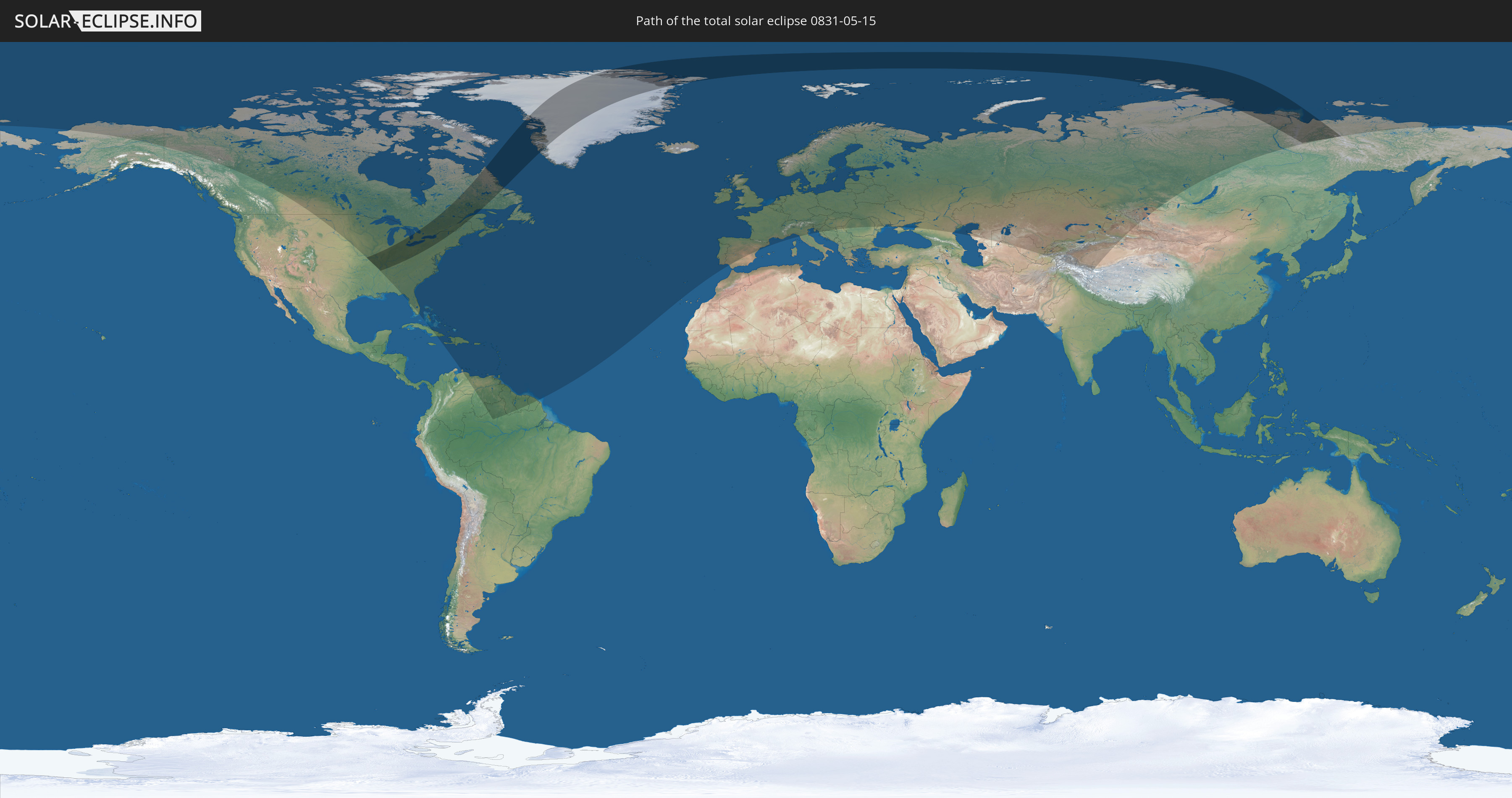
Die Sonnenfinsternis am 15.05.0831 kann man in 83 Ländern als partielle Sonnenfinsternis beobachten.
Der Finsternispfad verläuft durch 4 Länder. Nur in diesen Ländern ist sie als totale Sonnenfinsternis zu sehen.
In den folgenden Ländern ist die Sonnenfinsternis total zu sehen
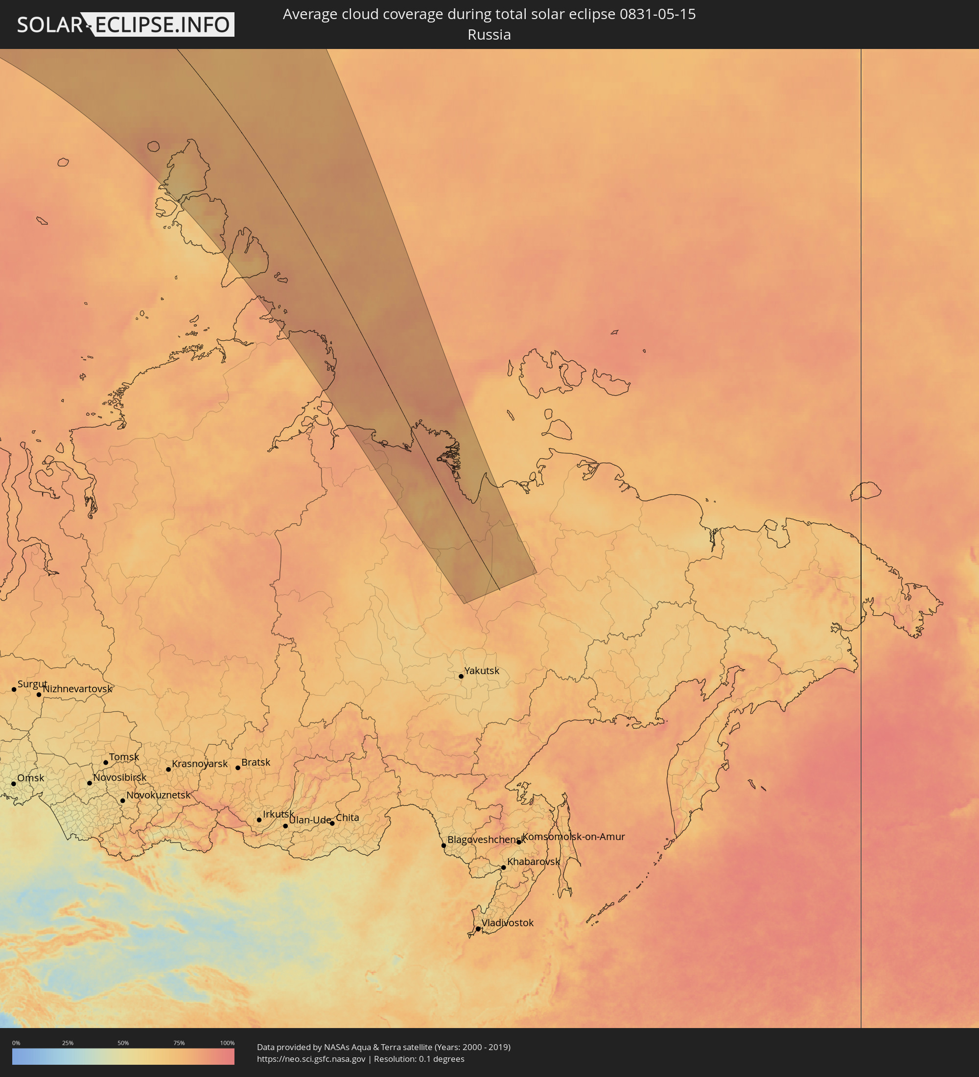
 Russland
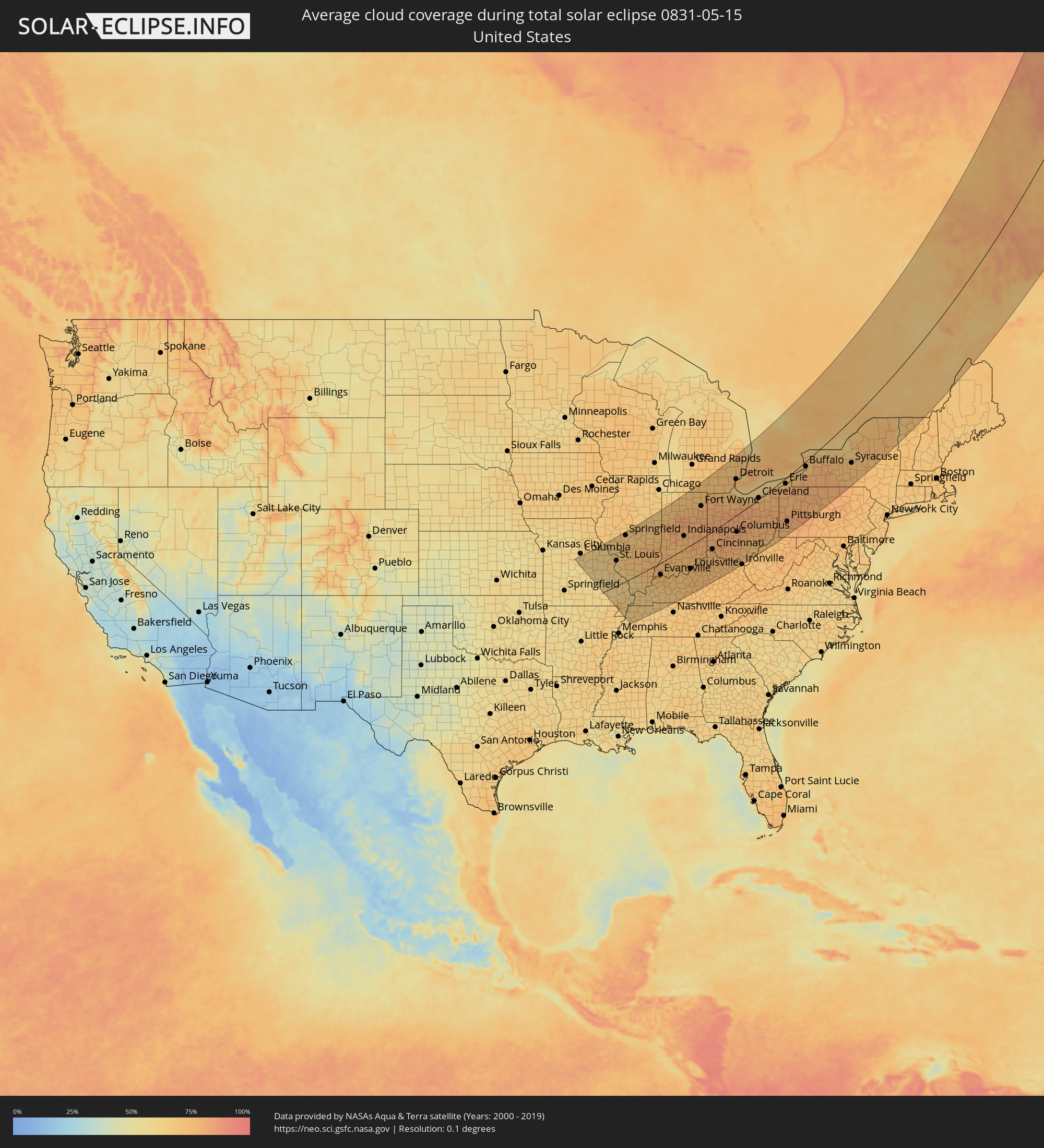
 Vereinigte Staaten
 Kanada
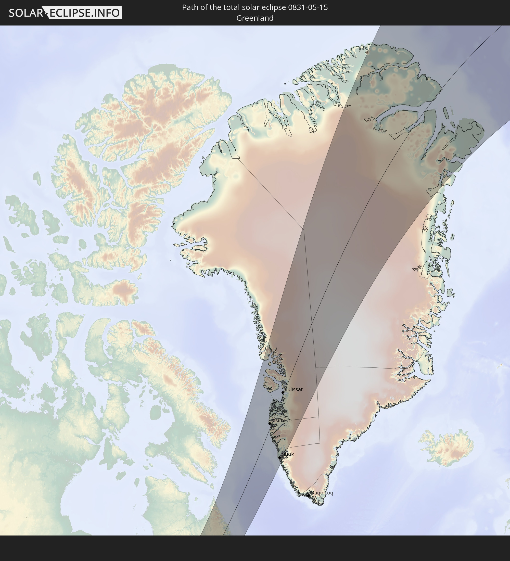 Grönland
In den folgenden Ländern ist die Sonnenfinsternis partiell zu sehen
 Russland
 Vereinigte Staaten
 Kanada
 Grönland
 Kuba
Kuba
 Bahamas
 Haiti
Haiti
 Brasilien
 Venezuela
 Turks- und Caicosinseln
 Dominikanische Republik
 Aruba
Aruba
 Puerto Rico
 Amerikanische Jungferninseln
 Bermuda
 Britische Jungferninseln
 Anguilla
 Saint-Martin
 Saint-Barthélemy
 St. Kitts und Nevis
 Antigua und Barbuda
 Montserrat
 Trinidad und Tobago
 Guadeloupe
 Grenada
 Dominica
 St. Vincent und die Grenadinen
 Guyana
 Martinique
 St. Lucia
 Barbados
 Suriname
 Saint-Pierre und Miquelon
 Französisch-Guayana
 Portugal
 Island
 Spanien
 Irland
 Spitzbergen
 Vereinigtes Königreich
 Färöer
 Frankreich
 Isle of Man
 Guernsey
 Jersey
 Andorra
 Belgien
 Niederlande
 Norwegen
 Luxemburg
 Deutschland
 Schweiz
 Italien
 Monaco
 Dänemark
 Liechtenstein
 Österreich
 Schweden
 Tschechien
 Slowenien
 Kroatien
 Polen
Polen
 Bosnien und Herzegowina
 Ungarn
 Slowakei
 Serbien
 Åland Islands
 Rumänien
 Finnland
 Litauen
 Lettland
 Estland
 Ukraine
 Weißrussland
 Moldawien
 Kasachstan
 Turkmenistan
 Usbekistan
 Afghanistan
 Tadschikistan
 Kirgisistan
 Volksrepublik China
 Mongolei
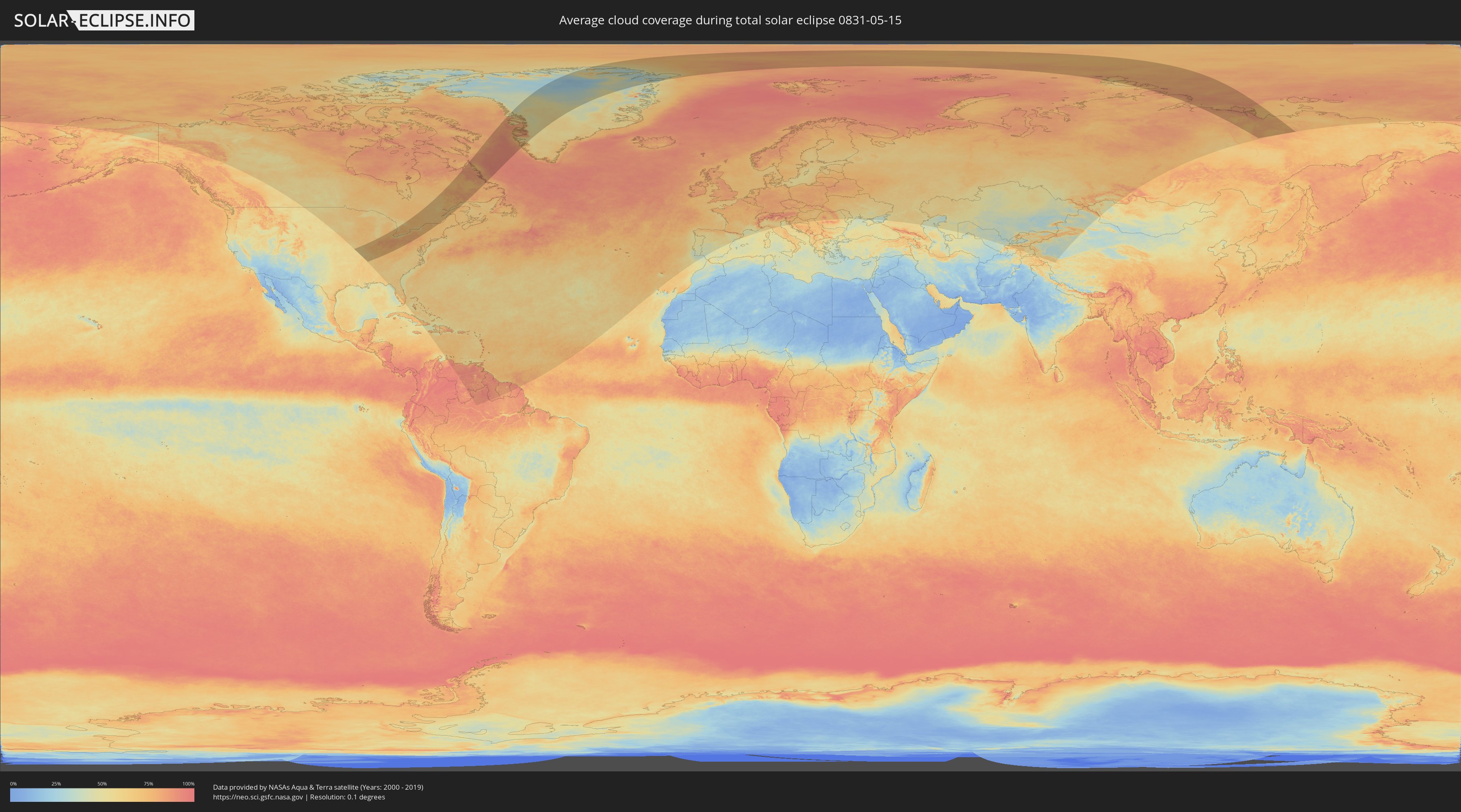
Wie wird das Wetter während der totalen Sonnenfinsternis am 15.05.0831?
Wo ist der beste Ort, um die totale Sonnenfinsternis vom 15.05.0831 zu beobachten?
Die folgenden Karten zeigen die durchschnittliche Bewölkung für den Tag, an dem die totale Sonnenfinsternis
stattfindet. Mit Hilfe der Karten lässt sich der Ort entlang des Finsternispfades eingrenzen,
der die besten Aussichen auf einen klaren wolkenfreien Himmel bietet.
Trotzdem muss man immer lokale Gegenenheiten beachten und sollte sich genau über das Wetter an seinem
gewählten Beobachtungsort informieren.
Die Daten stammen von den beiden NASA-Satelliten
AQUA und TERRA
und wurden über einen Zeitraum von 19 Jahren (2000 - 2019) gemittelt.

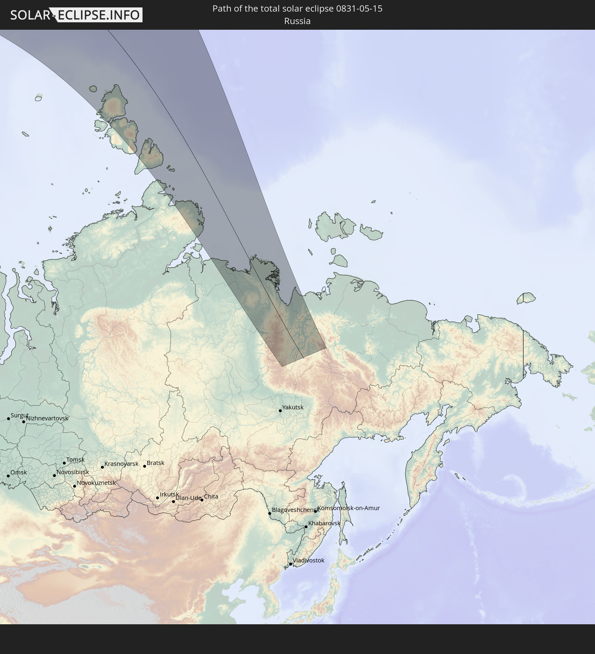
Detaillierte Länderkarten
 Russland
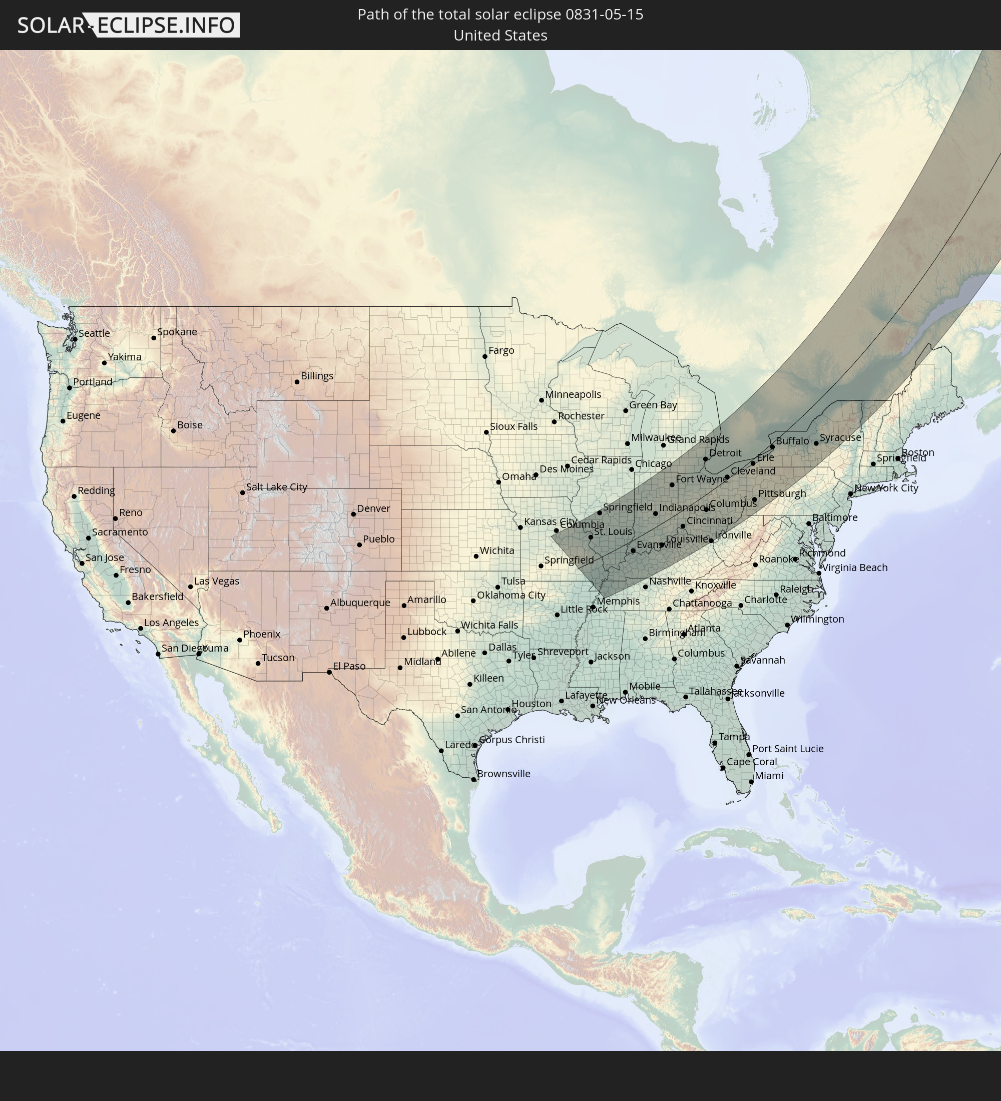
 Vereinigte Staaten
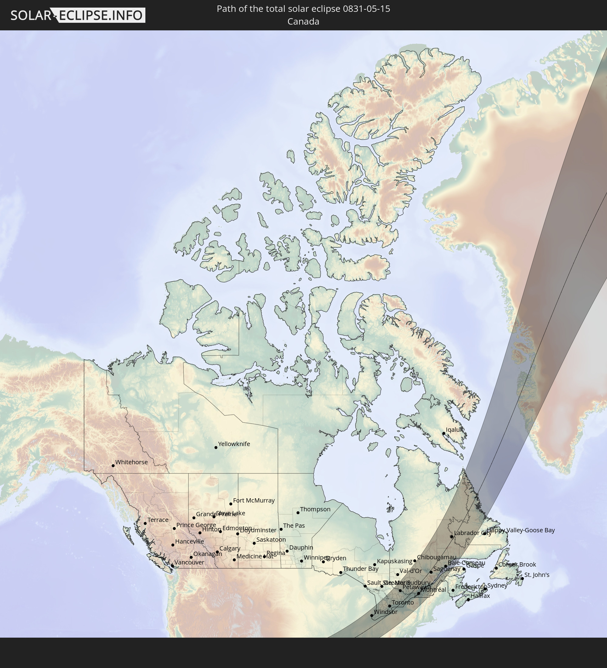
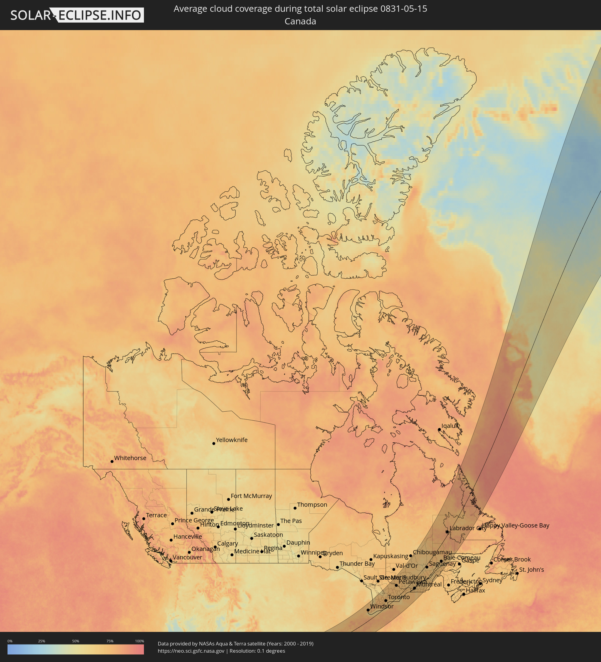 Kanada
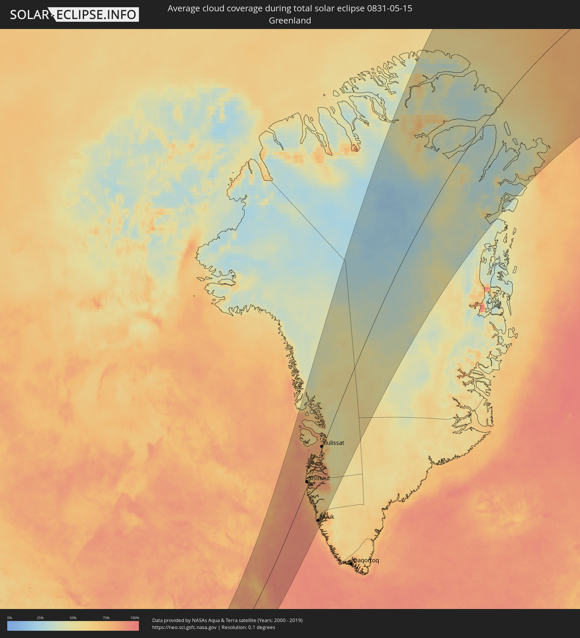 Grönland
Orte im Finsternispfad
Die nachfolgene Tabelle zeigt Städte und Orte mit mehr als 5.000 Einwohnern, die sich im Finsternispfad befinden. Städte mit mehr als 100.000 Einwohnern sind dick gekennzeichnet. Mit einem Klick auf den Ort öffnet sich eine Detailkarte die die Lage des jeweiligen Ortes zusammen mit dem Verlauf der zentralen Finsternis präsentiert.
| Ort | Typ | Dauer der Verfinsterung | Ortszeit bei maximaler Verfinsterung | Entfernung zur Zentrallinie | Ø Bewölkung |
|
O'Fallon, Missouri
|
total | - | 04:57:37 UTC-06:00 | 157 km | 60% |
|
Saint Charles, Missouri
|
total | - | 04:57:29 UTC-06:00 | 147 km | 63% |
|
St. Louis, Missouri
|
total | - | 04:57:09 UTC-06:00 | 119 km | 63% |
|
Springfield, Illinois
|
total | - | 04:58:28 UTC-06:00 | 211 km | 67% |
|
Decatur, Illinois
|
total | - | 04:58:13 UTC-06:00 | 187 km | 68% |
|
Champaign, Illinois
|
total | - | 04:58:18 UTC-06:00 | 184 km | 70% |
|
Evansville, Indiana
|
total | - | 04:55:09 UTC-06:00 | 56 km | 71% |
|
Terre Haute, Indiana
|
total | - | 05:57:06 UTC-05:00 | 85 km | 72% |
|
Clarksville, Tennessee
|
total | - | 04:53:10 UTC-06:00 | 204 km | 66% |
|
Owensboro, Kentucky
|
total | - | 04:54:42 UTC-06:00 | 93 km | 73% |
|
Lafayette, Indiana
|
total | - | 05:58:11 UTC-05:00 | 152 km | 75% |
|
Bloomington, Indiana
|
total | - | 05:56:20 UTC-05:00 | 19 km | 72% |
|
Bowling Green, Kentucky
|
total | - | 04:53:23 UTC-06:00 | 197 km | 71% |
|
Indianapolis, Indiana
|
total | - | 05:57:01 UTC-05:00 | 61 km | 75% |
|
Carmel, Indiana
|
total | - | 05:57:18 UTC-05:00 | 78 km | 73% |
|
Elkhart, Indiana
|
total | - | 05:59:38 UTC-05:00 | 229 km | 70% |
|
Louisville, Kentucky
|
total | - | 05:54:48 UTC-05:00 | 105 km | 73% |
|
Anderson, Indiana
|
total | - | 05:57:19 UTC-05:00 | 73 km | 76% |
|
Muncie, Indiana
|
total | - | 05:57:20 UTC-05:00 | 63 km | 75% |
|
Fort Wayne, Indiana
|
total | - | 05:58:34 UTC-05:00 | 140 km | 76% |
|
Hamilton, Ohio
|
total | - | 05:55:56 UTC-05:00 | 51 km | 76% |
|
Lexington-Fayette, Kentucky
|
total | - | 05:54:02 UTC-05:00 | 182 km | 74% |
|
Cincinnati, Ohio
|
total | - | 05:55:34 UTC-05:00 | 77 km | 79% |
|
Dayton, Ohio
|
total | - | 05:56:18 UTC-05:00 | 34 km | 75% |
|
Springfield, Ohio
|
total | - | 05:56:24 UTC-05:00 | 35 km | 80% |
|
Ann Arbor, Michigan
|
total | - | 05:59:46 UTC-05:00 | 176 km | 72% |
|
Flint, Michigan
|
total | - | 06:00:49 UTC-05:00 | 239 km | 72% |
|
Toledo, Ohio
|
total | - | 05:58:49 UTC-05:00 | 114 km | 70% |
|
Novi, Michigan
|
total | - | 05:59:58 UTC-05:00 | 181 km | 72% |
|
Waterford, Michigan
|
total | - | 06:00:16 UTC-05:00 | 197 km | 69% |
|
Livonia, Michigan
|
total | - | 05:59:46 UTC-05:00 | 165 km | 75% |
|
Taylor, Michigan
|
total | - | 05:59:34 UTC-05:00 | 150 km | 72% |
|
Southfield, Michigan
|
total | - | 05:59:53 UTC-05:00 | 168 km | 72% |
|
Troy, Michigan
|
total | - | 06:00:04 UTC-05:00 | 176 km | 73% |
|
Detroit, Michigan
|
total | - | 05:59:38 UTC-05:00 | 147 km | 73% |
|
Warren, Michigan
|
total | - | 05:59:50 UTC-05:00 | 159 km | 72% |
|
Windsor, Ontario
|
total | - | 05:59:34 UTC-05:00 | 143 km | 73% |
|
Columbus, Ohio
|
total | - | 05:56:12 UTC-05:00 | 70 km | 79% |
|
Clinton, Michigan
|
total | - | 05:59:58 UTC-05:00 | 163 km | 71% |
|
Sarnia, Ontario
|
total | - | 06:00:24 UTC-05:00 | 172 km | 70% |
|
Lorain, Ohio
|
total | - | 05:58:05 UTC-05:00 | 26 km | 67% |
|
Cleveland, Ohio
|
total | - | 05:58:01 UTC-05:00 | 6 km | 71% |
|
Akron, Ohio
|
total | - | 05:57:21 UTC-05:00 | 41 km | 77% |
|
Canton, Ohio
|
total | - | 05:56:54 UTC-05:00 | 73 km | 79% |
|
London, Ontario
|
total | - | 06:00:05 UTC-05:00 | 113 km | 75% |
|
St. Thomas, Ontario
|
total | - | 05:59:46 UTC-05:00 | 92 km | 76% |
|
Woodstock, Ontario
|
total | - | 06:00:11 UTC-05:00 | 100 km | 75% |
|
Youngstown, Ohio
|
total | - | 05:57:08 UTC-05:00 | 83 km | 77% |
|
Kitchener, Ontario
|
total | - | 06:00:34 UTC-05:00 | 113 km | 76% |
|
Norfolk County, Ontario
|
total | - | 05:59:39 UTC-05:00 | 56 km | 73% |
|
Cambridge, Ontario
|
total | - | 06:00:26 UTC-05:00 | 97 km | 74% |
|
Brantford, Ontario
|
total | - | 06:00:04 UTC-05:00 | 77 km | 75% |
|
Guelph, Ontario
|
total | - | 06:00:42 UTC-05:00 | 110 km | 74% |
|
Erie, Pennsylvania
|
total | - | 05:58:31 UTC-05:00 | 33 km | 75% |
|
Pittsburgh, Pennsylvania
|
total | - | 05:55:59 UTC-05:00 | 174 km | 78% |
|
Milton, Ontario
|
total | - | 06:00:34 UTC-05:00 | 87 km | 73% |
|
Hamilton, Ontario
|
total | - | 06:00:09 UTC-05:00 | 65 km | 71% |
|
Burlington, Ontario
|
total | - | 06:00:21 UTC-05:00 | 74 km | 70% |
|
Barrie, Ontario
|
total | - | 06:01:52 UTC-05:00 | 150 km | 73% |
|
Mississauga, Ontario
|
total | - | 06:00:36 UTC-05:00 | 81 km | 72% |
|
Vaughan, Ontario
|
total | - | 06:00:58 UTC-05:00 | 94 km | 72% |
|
Newmarket, Ontario
|
total | - | 06:01:17 UTC-05:00 | 110 km | 73% |
|
Toronto, Ontario
|
total | - | 06:00:44 UTC-05:00 | 78 km | 69% |
|
Scarborough, Ontario
|
total | - | 06:00:49 UTC-05:00 | 76 km | 68% |
|
Welland, Ontario
|
total | - | 05:59:36 UTC-05:00 | 9 km | 70% |
|
St. Catharines, Ontario
|
total | - | 05:59:53 UTC-05:00 | 24 km | 68% |
|
Niagara Falls, Ontario
|
total | - | 05:59:44 UTC-05:00 | 9 km | 70% |
|
Niagara Falls, New York
|
total | - | 05:59:44 UTC-05:00 | 8 km | 70% |
|
Ajax, Ontario
|
total | - | 06:00:53 UTC-05:00 | 70 km | 68% |
|
Buffalo, New York
|
total | - | 05:59:22 UTC-05:00 | 19 km | 66% |
|
Oshawa, Ontario
|
total | - | 06:00:55 UTC-05:00 | 64 km | 67% |
|
Peterborough, Ontario
|
total | - | 06:01:26 UTC-05:00 | 73 km | 71% |
|
Rochester, New York
|
total | - | 05:59:31 UTC-05:00 | 64 km | 71% |
|
Belleville, Ontario
|
total | - | 06:01:02 UTC-05:00 | 21 km | 69% |
|
Kingston, Ontario
|
total | - | 06:00:59 UTC-05:00 | 43 km | 63% |
|
Syracuse, New York
|
total | - | 05:59:04 UTC-05:00 | 152 km | 73% |
|
Ottawa, Ontario
|
total | - | 06:02:44 UTC-05:00 | 16 km | 70% |
|
Utica, New York
|
total | - | 05:59:00 UTC-05:00 | 198 km | 72% |
|
Cornwall, Ontario
|
total | - | 06:01:58 UTC-05:00 | 73 km | 70% |
|
Salaberry-de-Valleyfield, Quebec
|
total | - | 06:02:16 UTC-05:00 | 88 km | 69% |
|
Mirabel, Quebec
|
total | - | 06:02:55 UTC-05:00 | 61 km | 69% |
|
Saint-Jérôme, Quebec
|
total | - | 06:03:07 UTC-05:00 | 54 km | 68% |
|
Blainville, Quebec
|
total | - | 06:02:55 UTC-05:00 | 69 km | 69% |
|
Dollard-Des Ormeaux, Quebec
|
total | - | 06:02:38 UTC-05:00 | 87 km | 66% |
|
Terrebonne, Quebec
|
total | - | 06:02:57 UTC-05:00 | 81 km | 66% |
|
Montréal, Quebec
|
total | - | 06:02:38 UTC-05:00 | 98 km | 65% |
|
Repentigny, Quebec
|
total | - | 06:03:00 UTC-05:00 | 92 km | 67% |
|
Joliette, Quebec
|
total | - | 06:03:26 UTC-05:00 | 70 km | 69% |
|
Saint-Jean-sur-Richelieu, Quebec
|
total | - | 06:02:16 UTC-05:00 | 132 km | 70% |
|
Sorel-Tracy, Quebec
|
total | - | 06:03:26 UTC-05:00 | 85 km | 68% |
|
Saint-Hyacinthe, Quebec
|
total | - | 06:02:46 UTC-05:00 | 126 km | 69% |
|
Shawinigan, Quebec
|
total | - | 06:04:17 UTC-05:00 | 67 km | 68% |
|
Granby, Quebec
|
total | - | 06:02:22 UTC-05:00 | 157 km | 72% |
|
Trois-Rivières, Quebec
|
total | - | 06:03:54 UTC-05:00 | 94 km | 67% |
|
Drummondville, Quebec
|
total | - | 06:03:08 UTC-05:00 | 135 km | 67% |
|
Victoriaville, Quebec
|
total | - | 06:03:22 UTC-05:00 | 150 km | 69% |
|
Sherbrooke, Quebec
|
total | - | 06:02:18 UTC-05:00 | 203 km | 72% |
|
Québec, Quebec
|
total | - | 06:04:35 UTC-05:00 | 137 km | 67% |
|
Saguenay, Quebec
|
total | - | 06:07:17 UTC-05:00 | 33 km | 67% |
|
Rimouski, Quebec
|
total | - | 06:07:19 UTC-05:00 | 176 km | 68% |
|
Sisimiut, Qeqqata
|
total | - | 08:16:35 UTC-03:26 | 21 km | 79% |
|
Nuuk, Sermersooq
|
total | - | 08:12:17 UTC-03:26 | 191 km | 77% |
|
Ilulissat, Qaasuitsup
|
total | - | 08:21:22 UTC-03:26 | 10 km | 73% |
|
Tiksi, Sakha
|
total | - | 21:19:47 UTC+08:38 | 69 km | 85% |