Totale Sonnenfinsternis vom 19.07.0939
| Wochentag: | Sonntag |
| Maximale Dauer der Verfinsterung: | 05m42s |
| Maximale Breite des Finsternispfades: | 267 km |
| Saroszyklus: | 109 |
| Bedeckungsgrad: | 100% |
| Magnitude: | 1.0748 |
| Gamma: | 0.4172 |
Wo kann man die Sonnenfinsternis vom 19.07.0939 sehen?
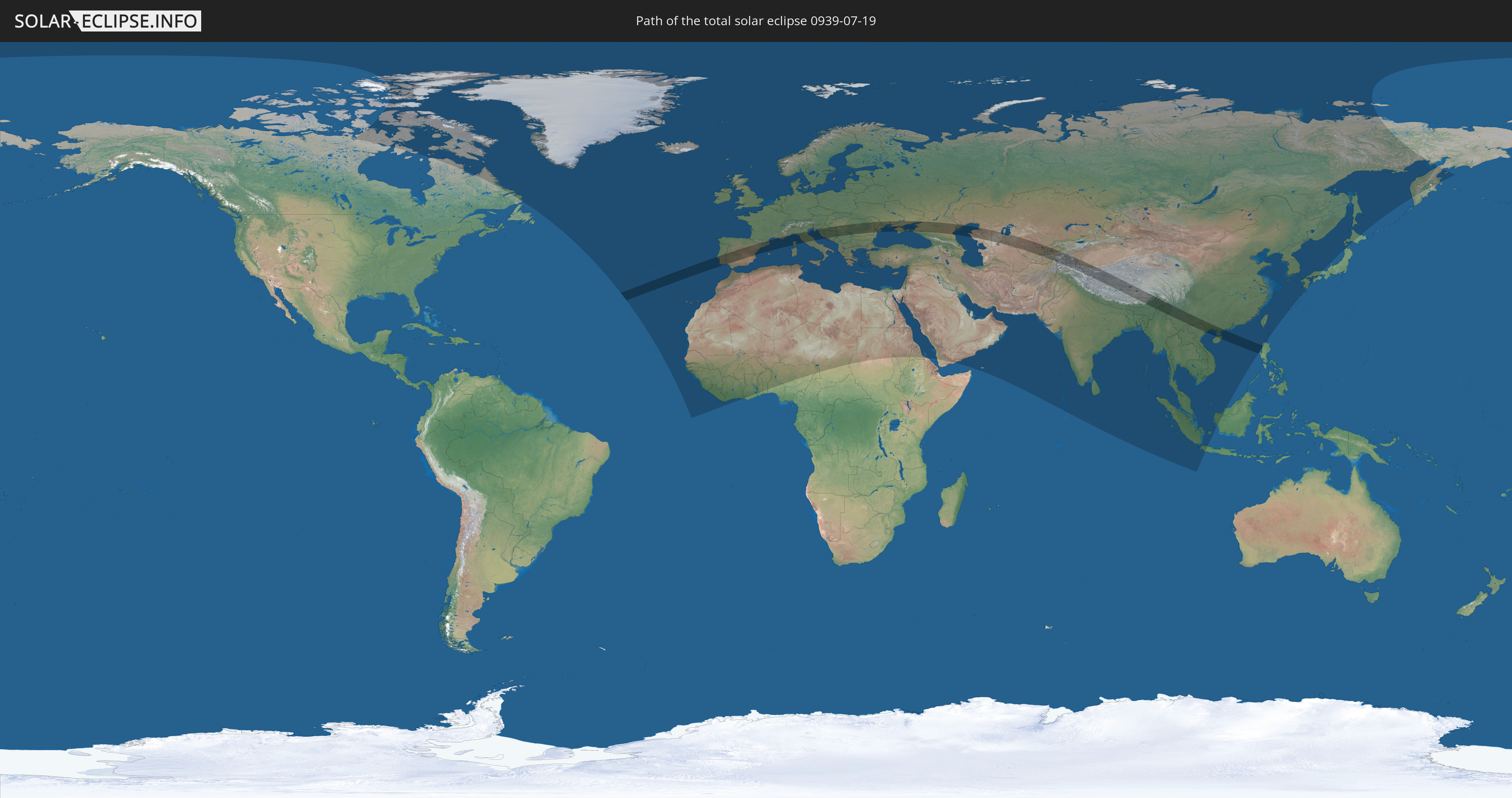
Die Sonnenfinsternis am 19.07.0939 kann man in 128 Ländern als partielle Sonnenfinsternis beobachten.
Der Finsternispfad verläuft durch 27 Länder. Nur in diesen Ländern ist sie als totale Sonnenfinsternis zu sehen.
In den folgenden Ländern ist die Sonnenfinsternis total zu sehen
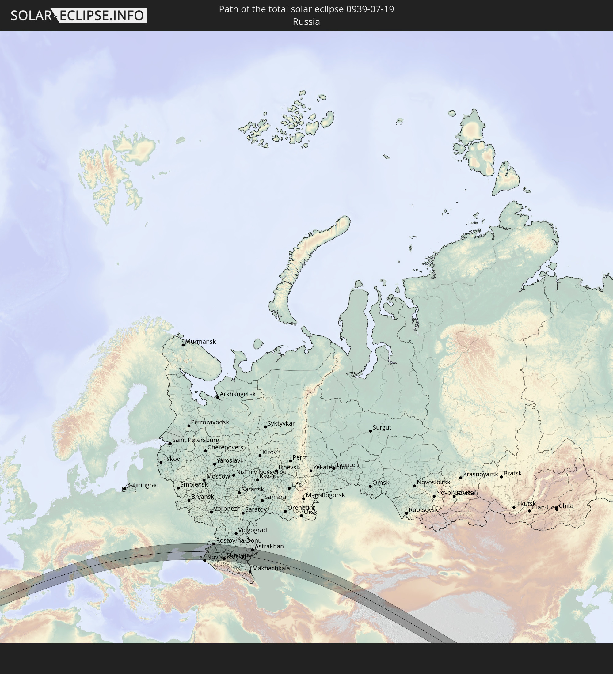 Russland
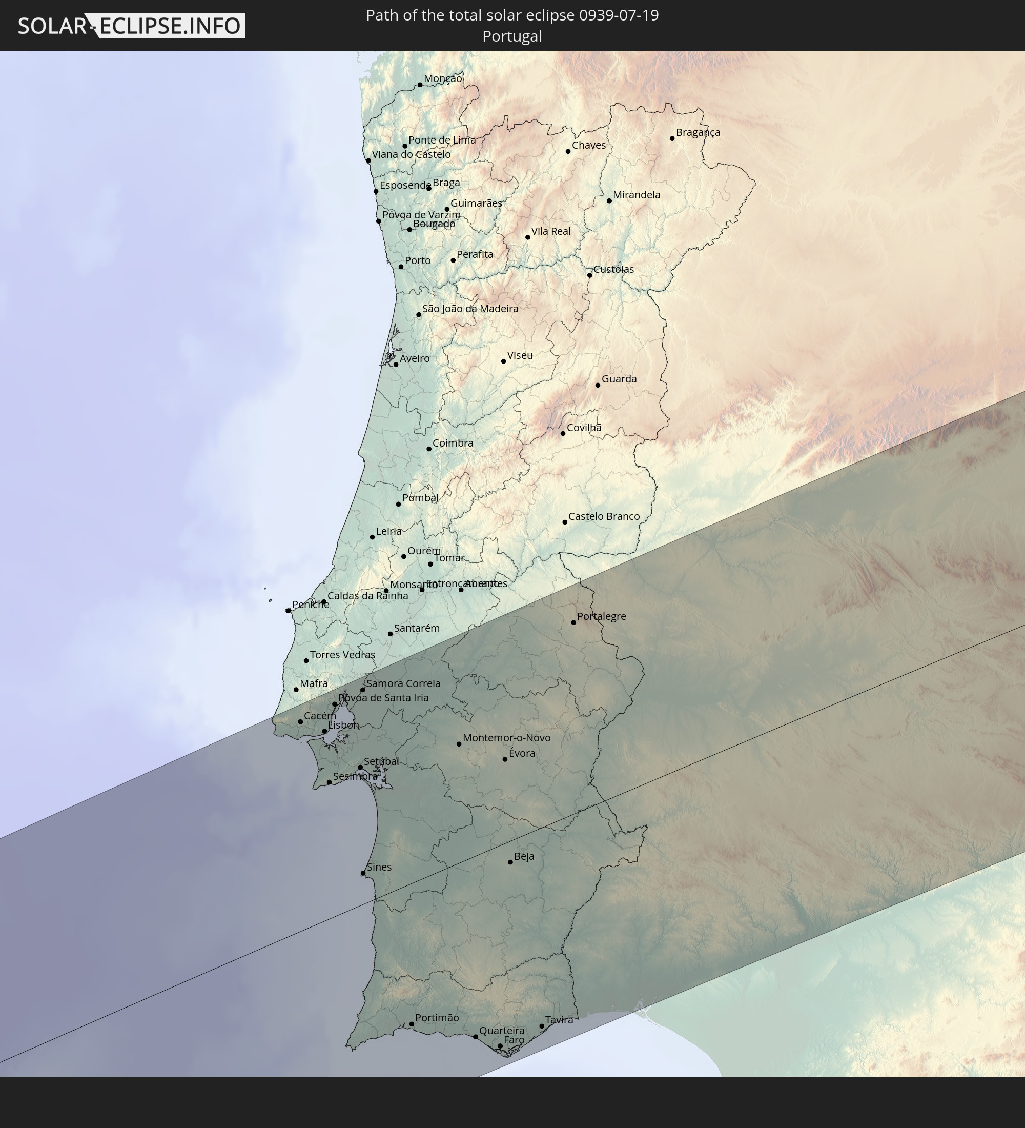 Portugal
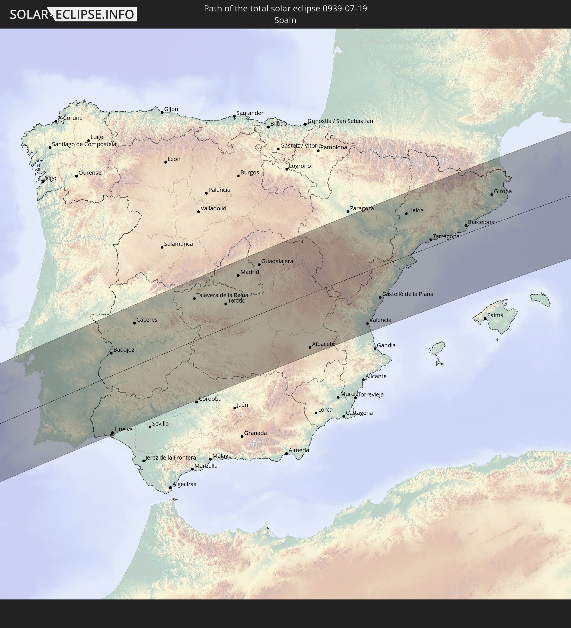 Spanien
 Frankreich
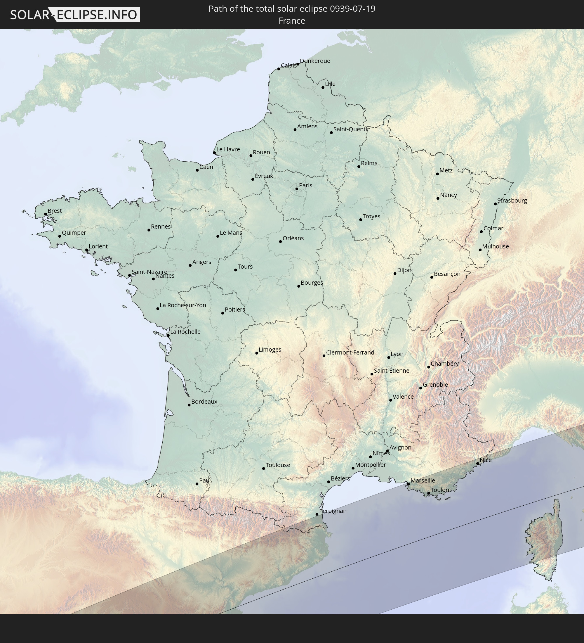
 Italien
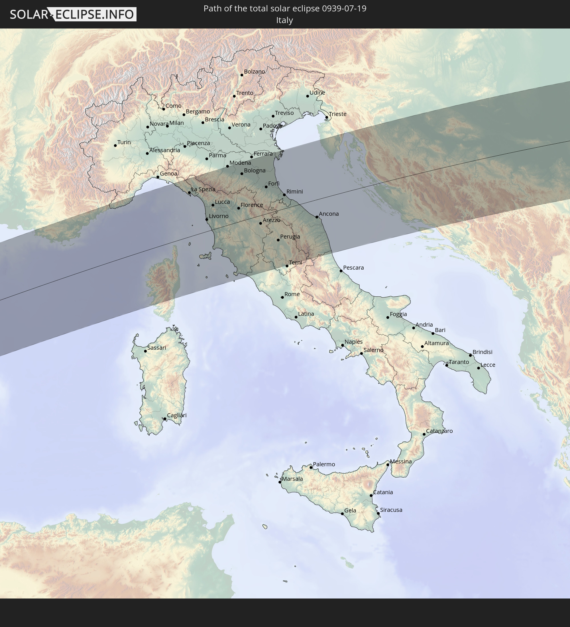
 Monaco
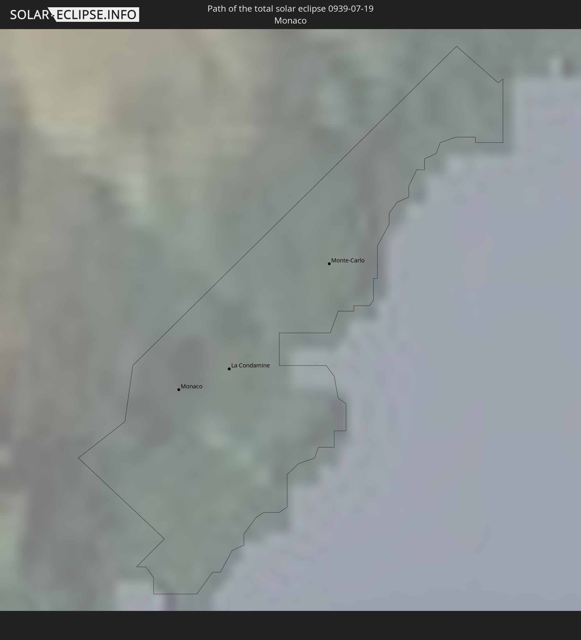
 San Marino
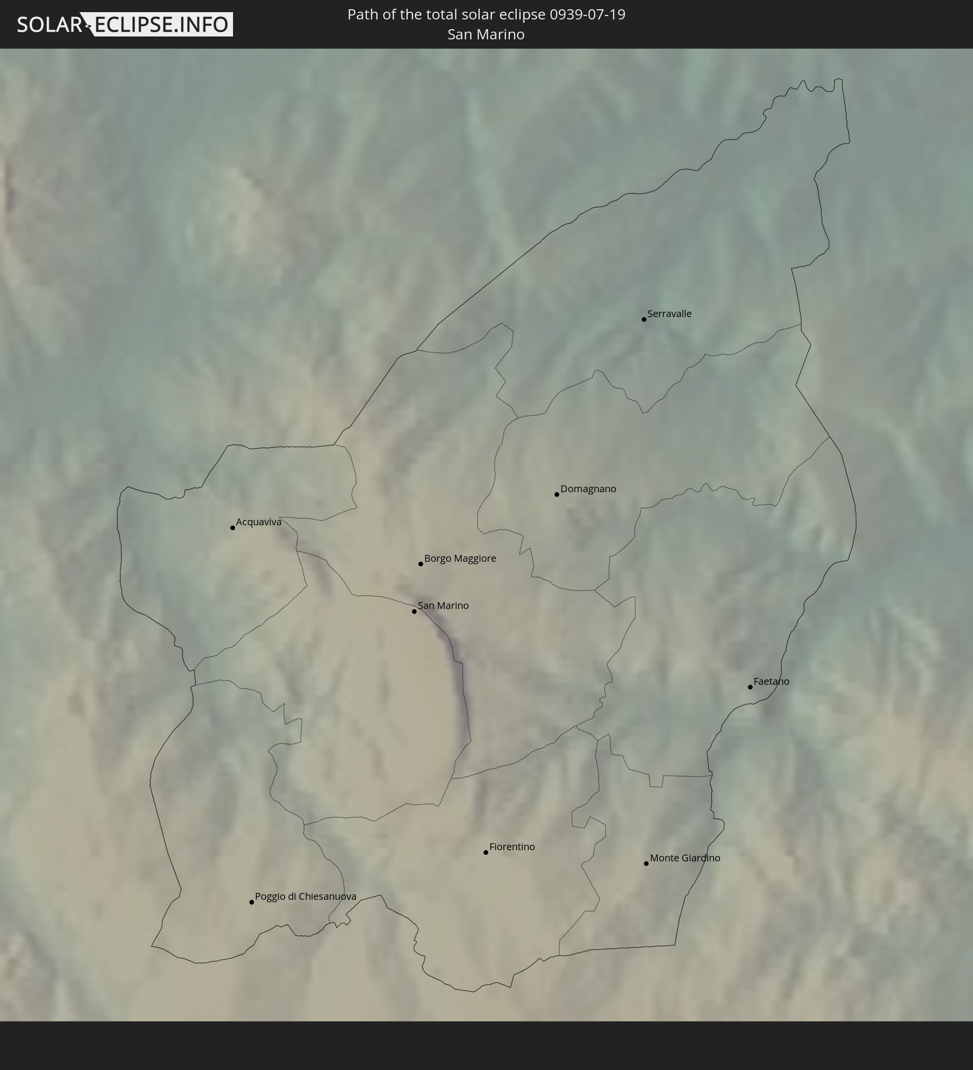
 Slowenien
 Kroatien
 Bosnien und Herzegowina
 Ungarn
 Serbien
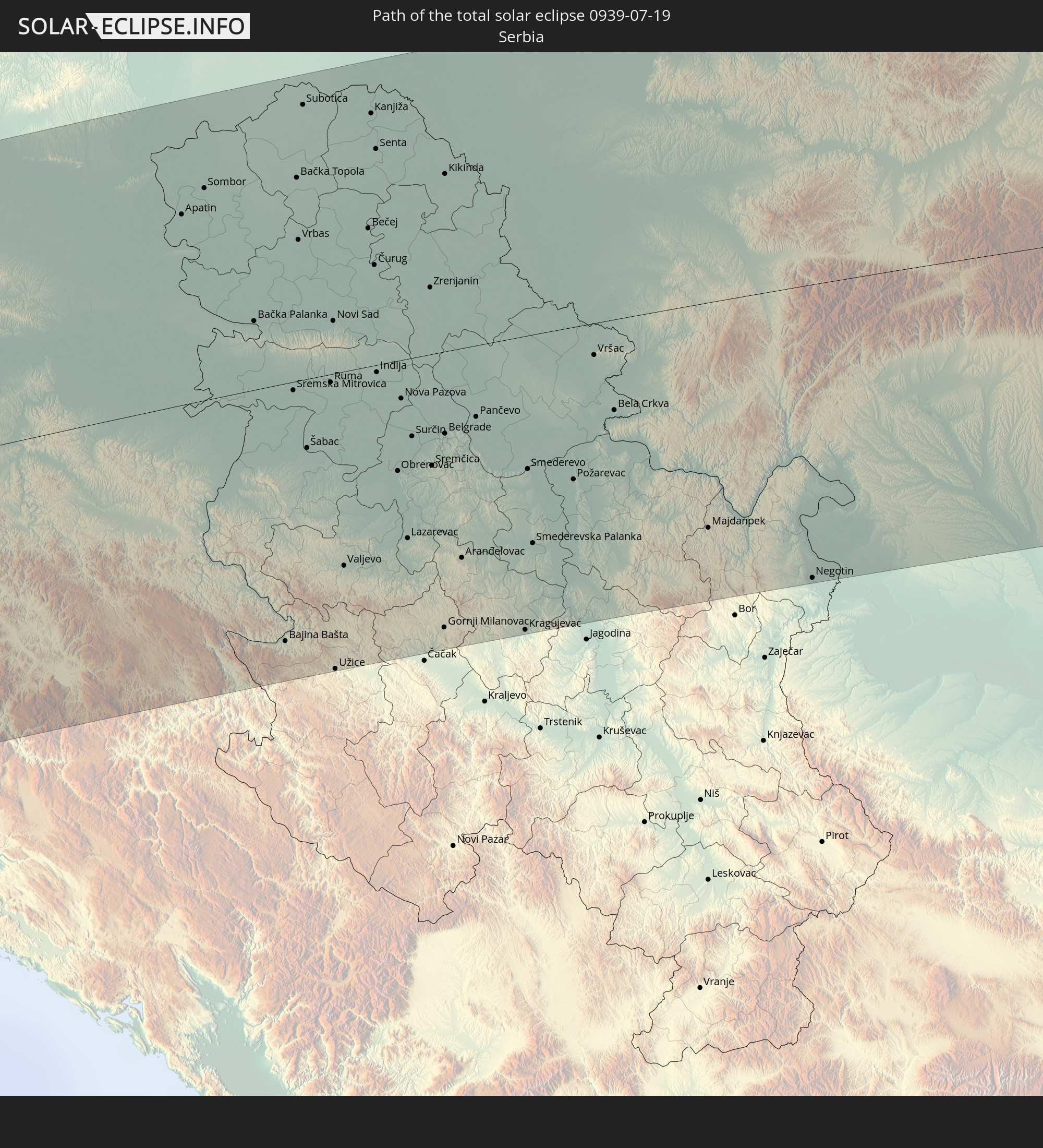
 Rumänien
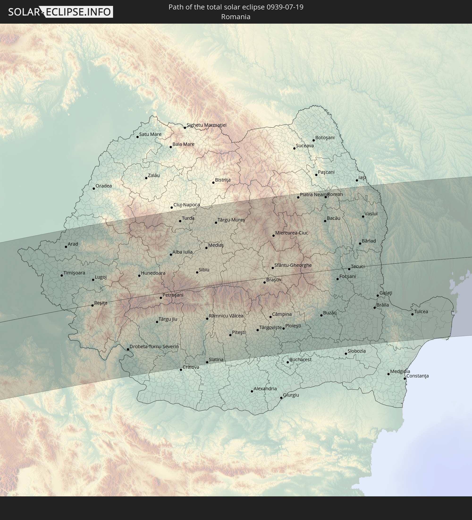
 Ukraine
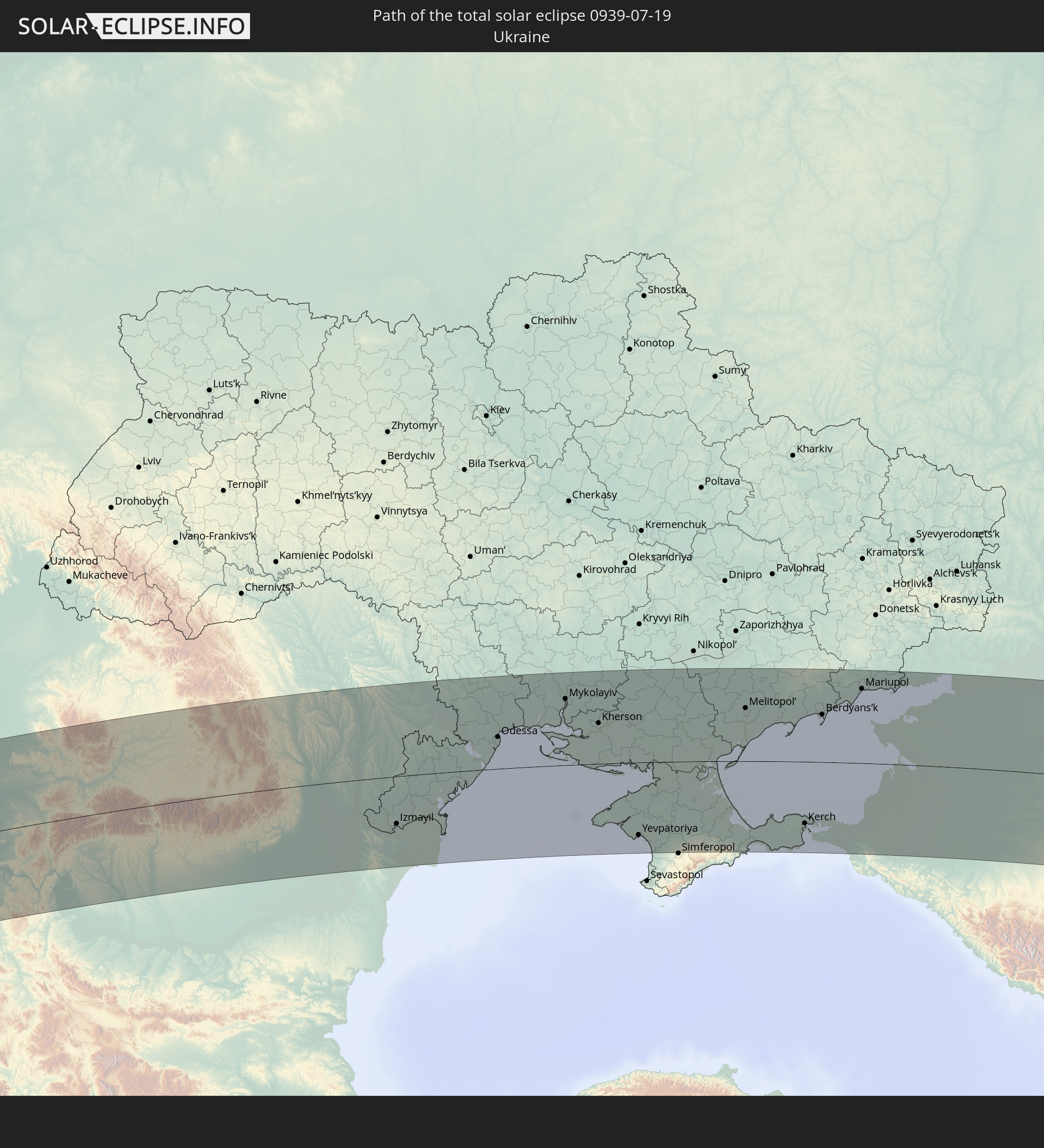
 Moldawien
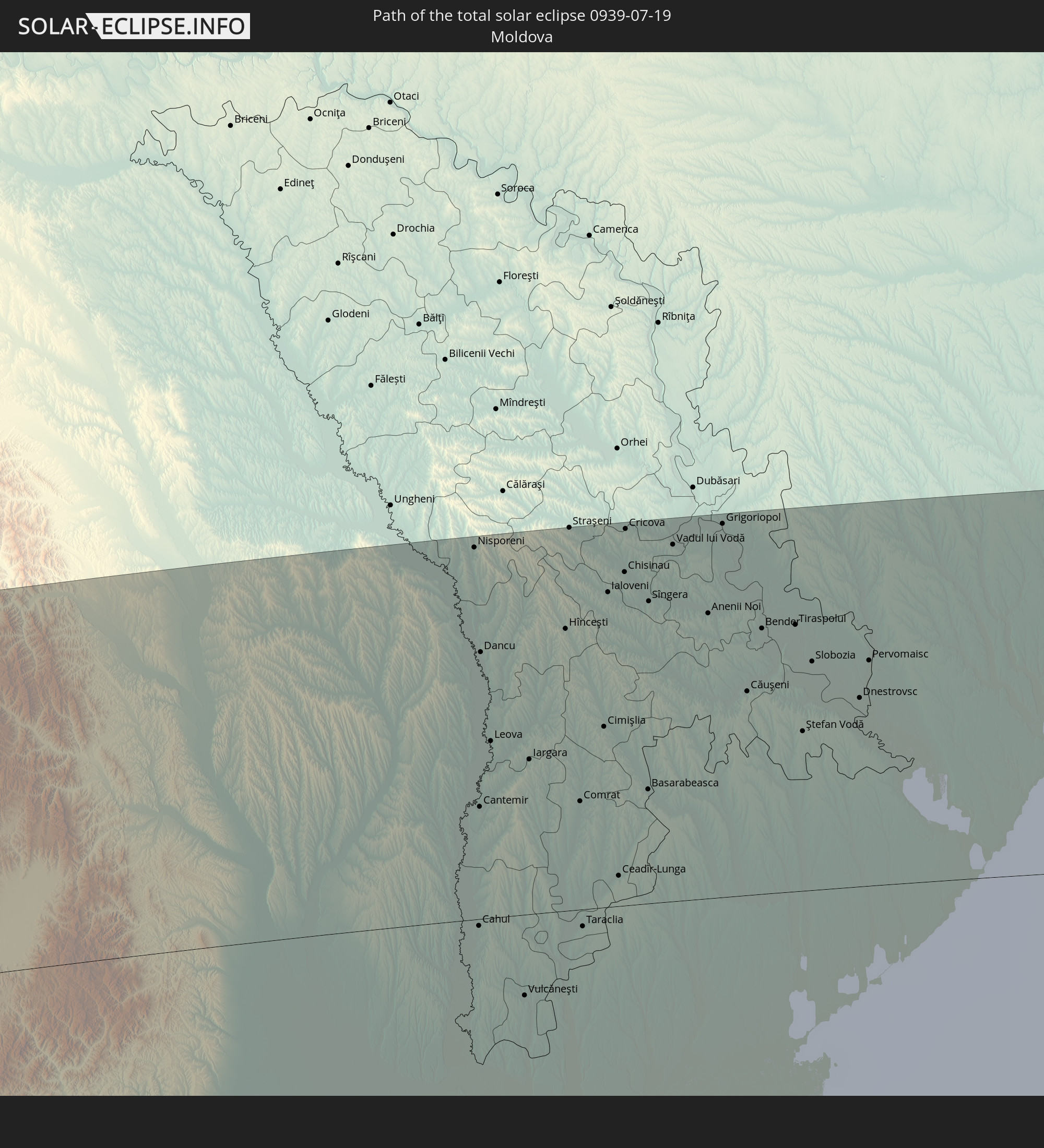
 Kasachstan
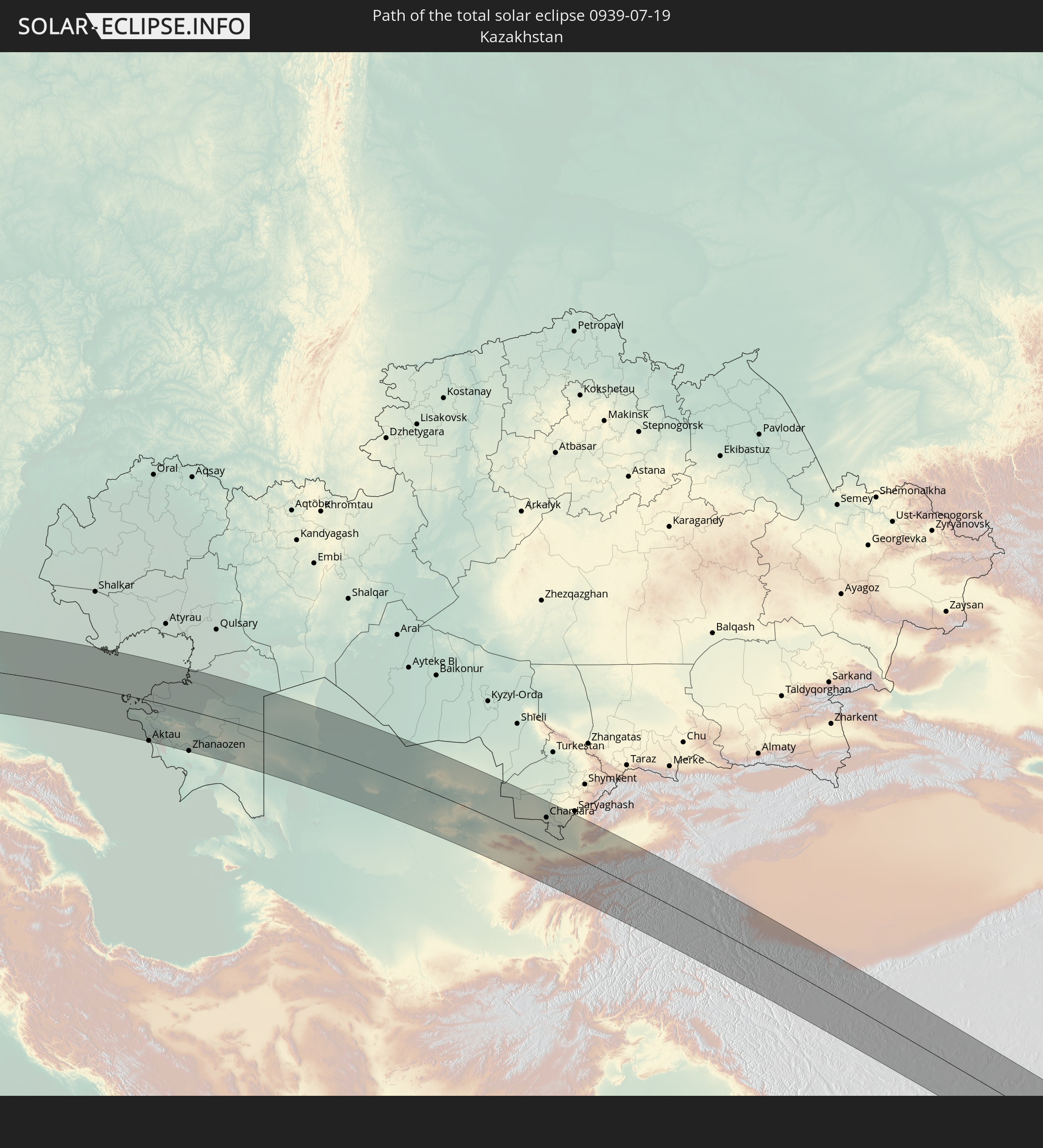
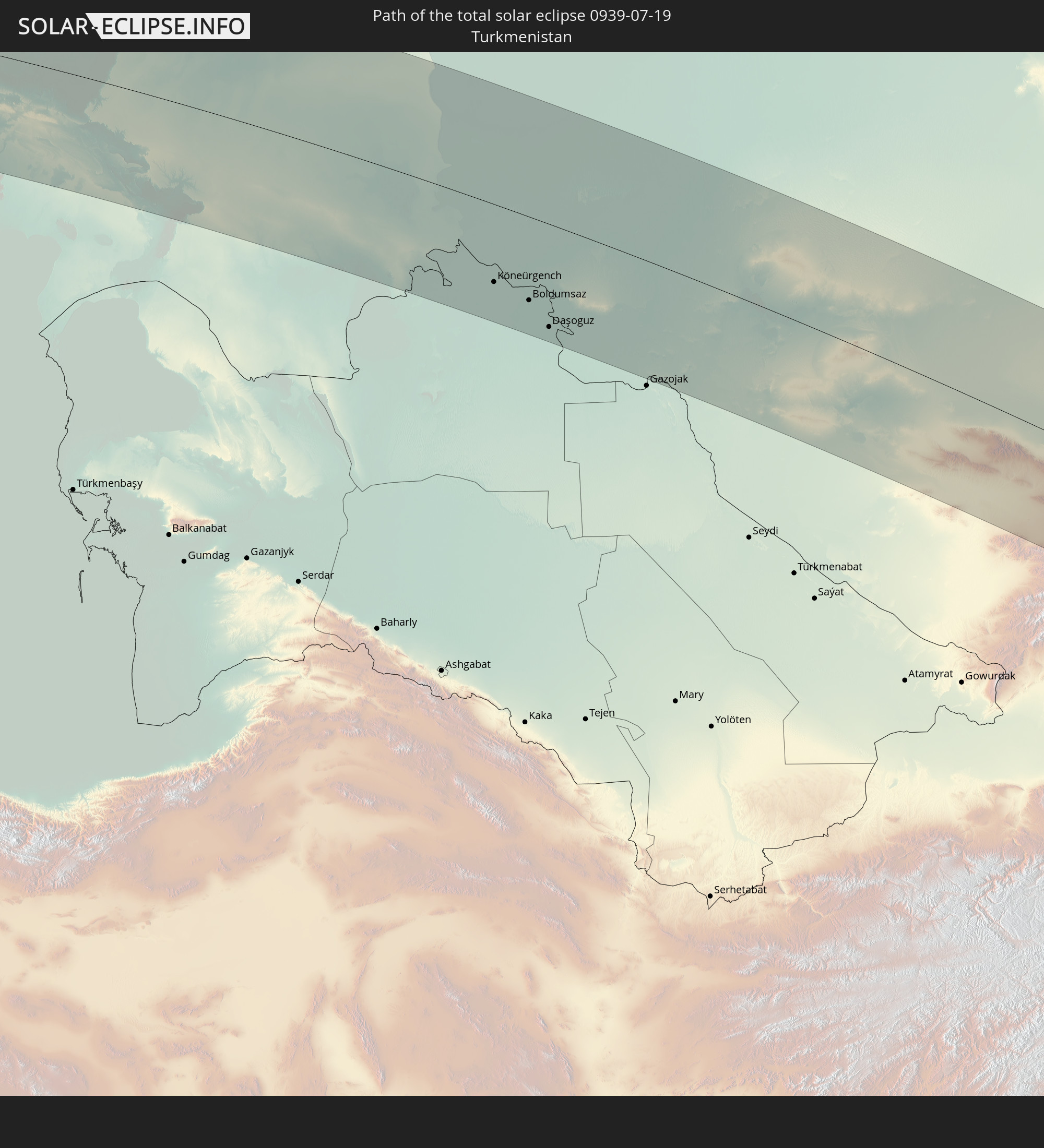 Turkmenistan
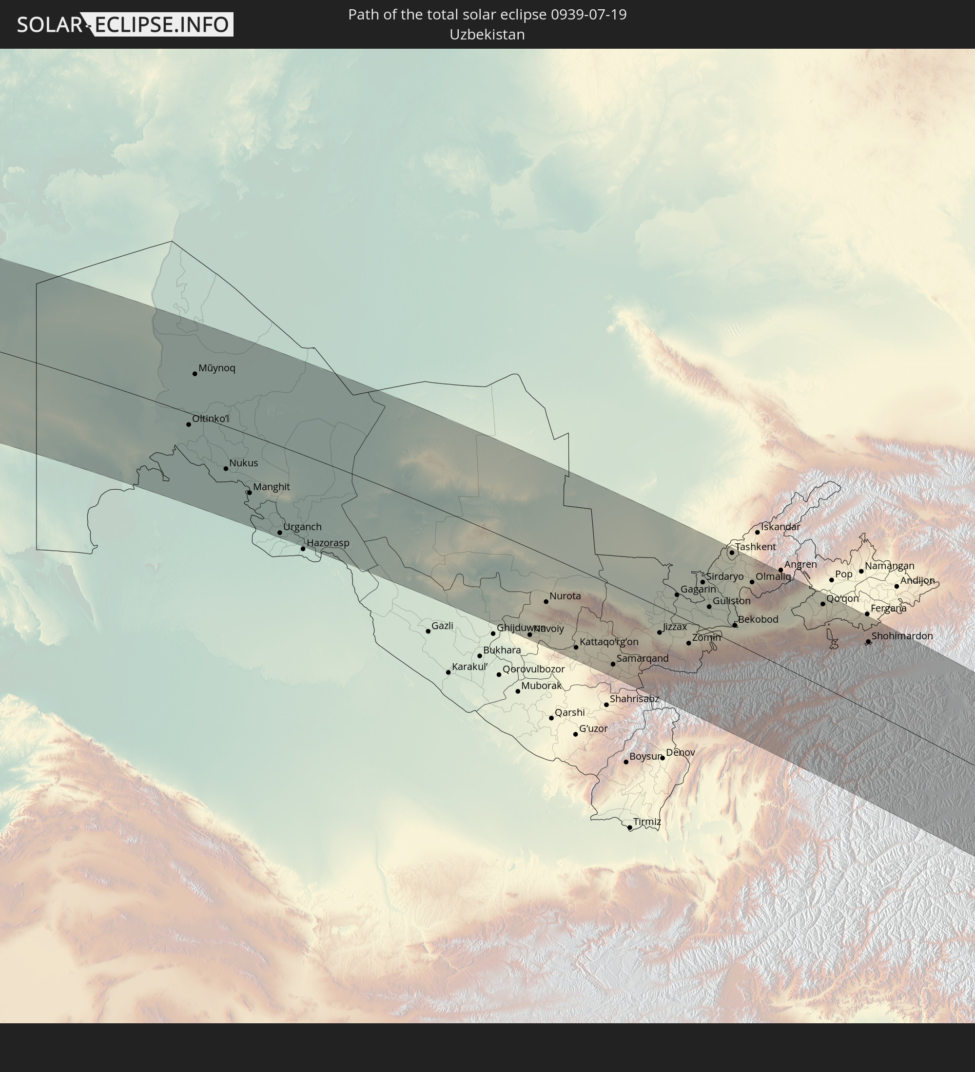 Usbekistan
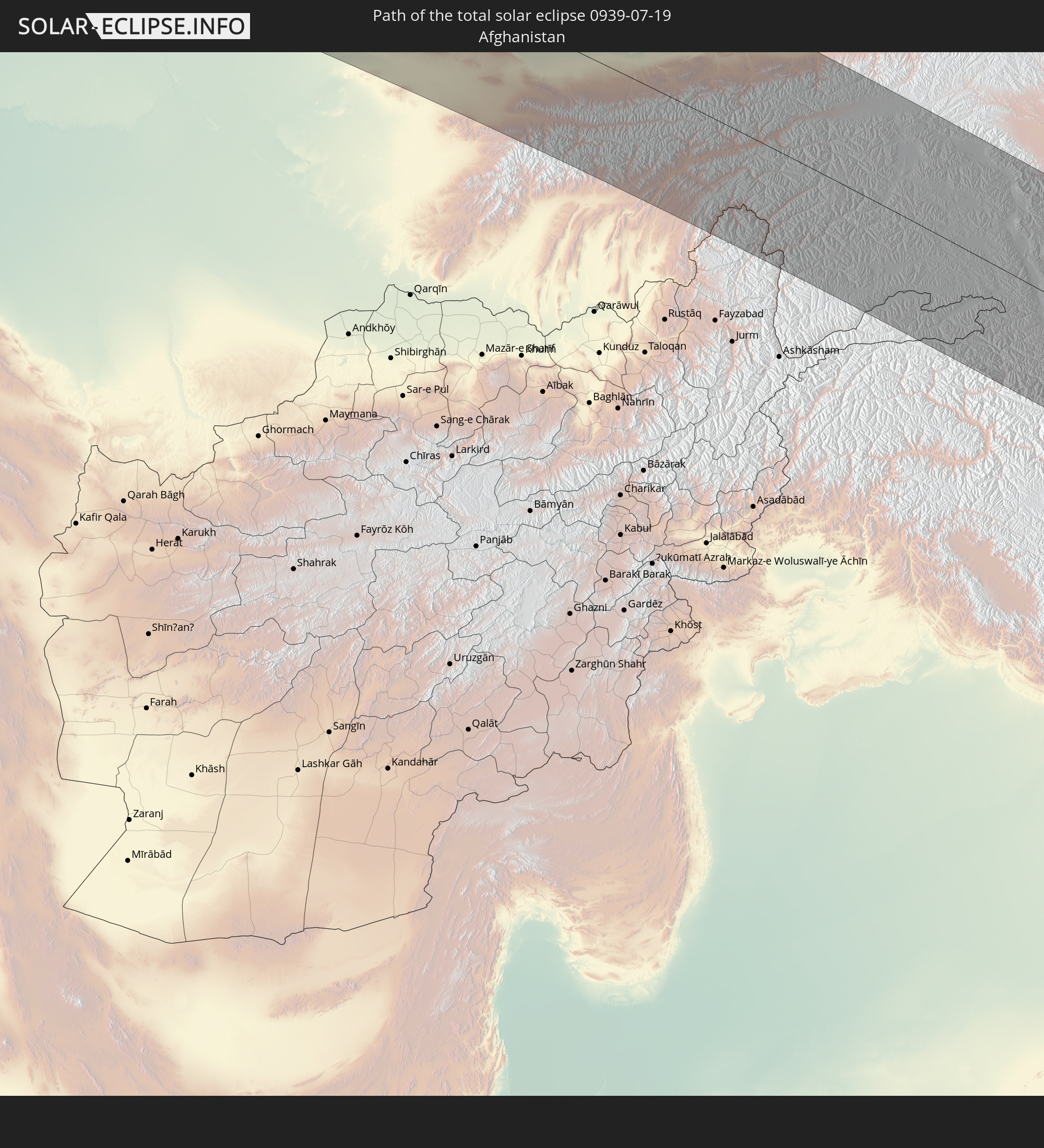 Afghanistan
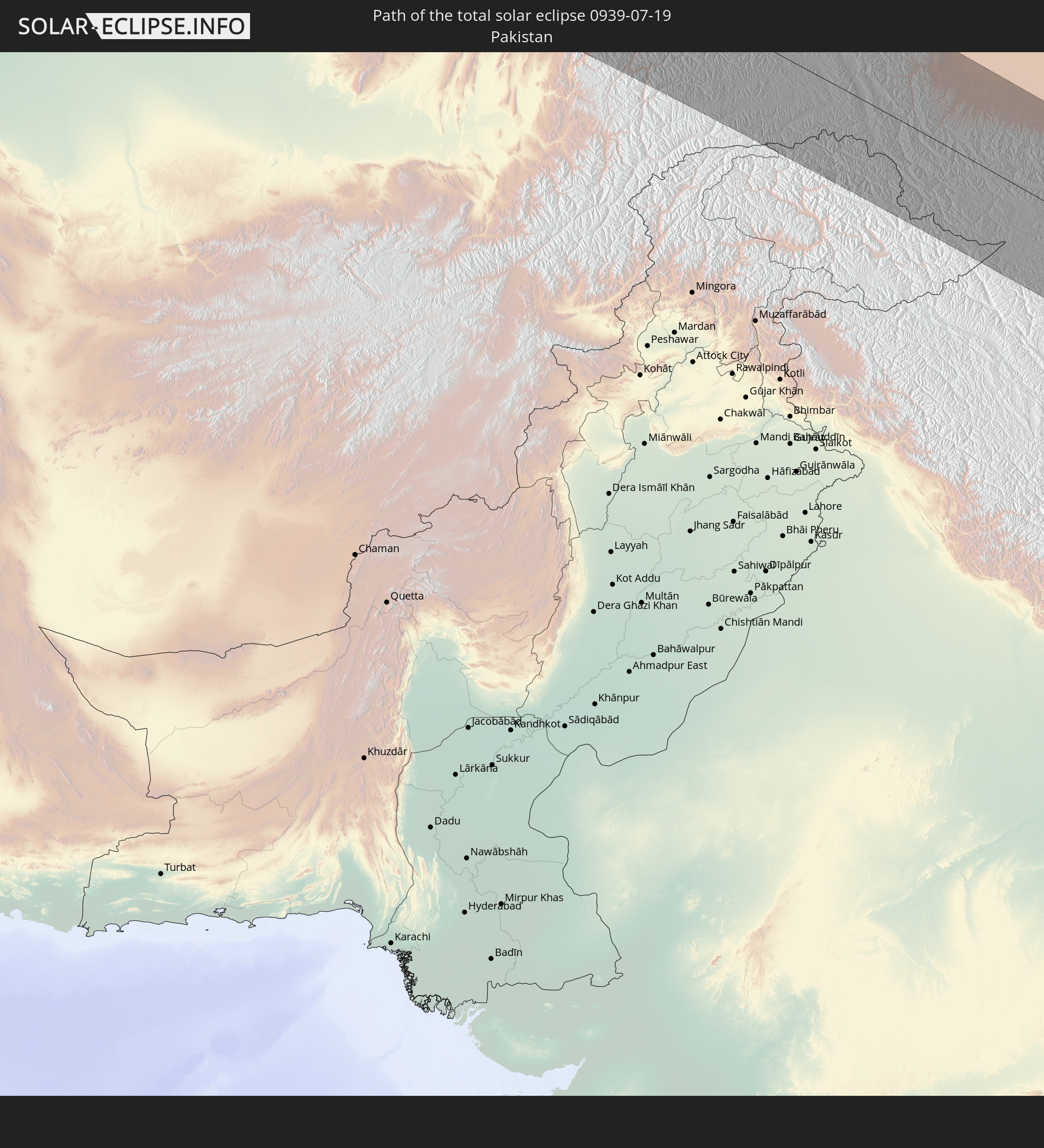 Pakistan
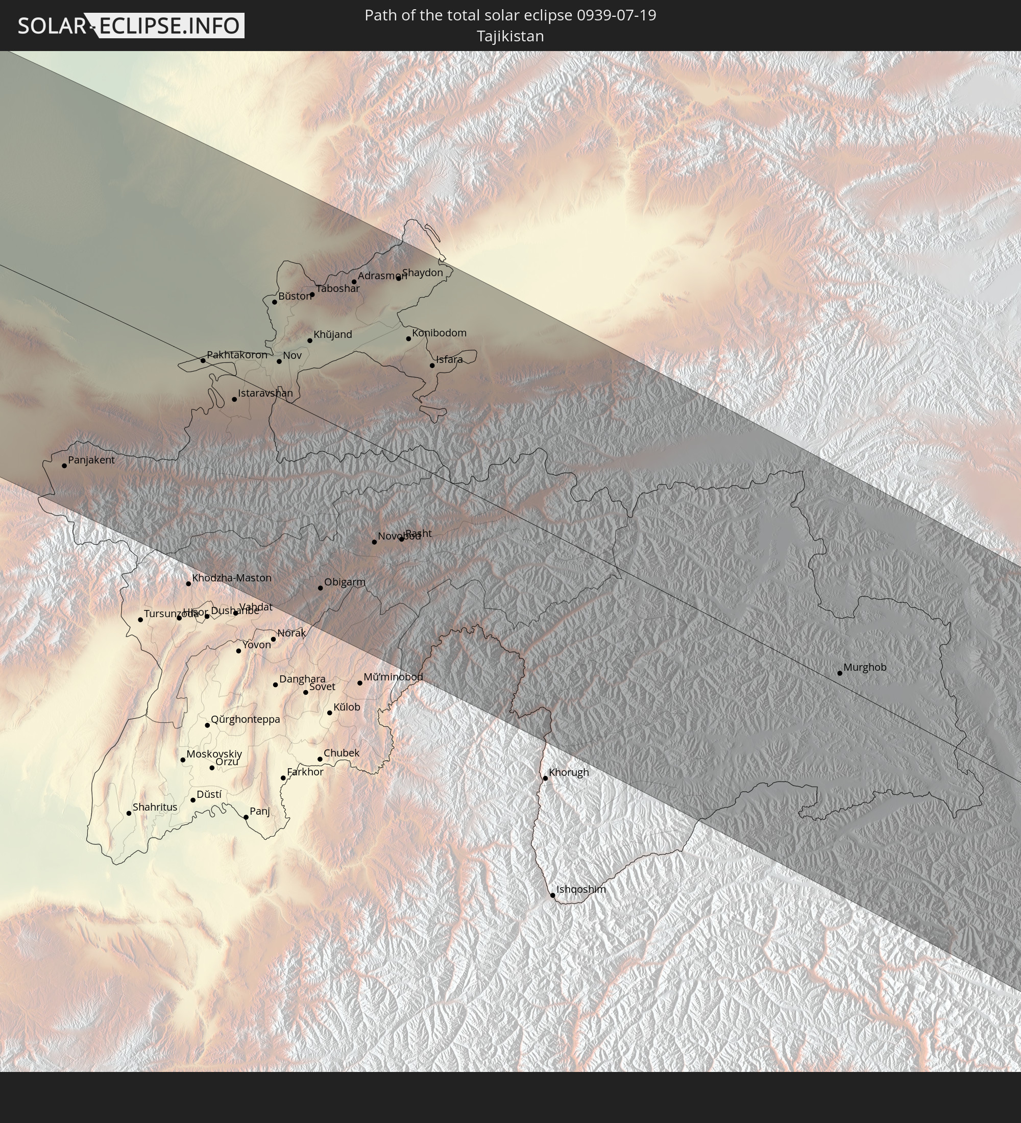 Tadschikistan
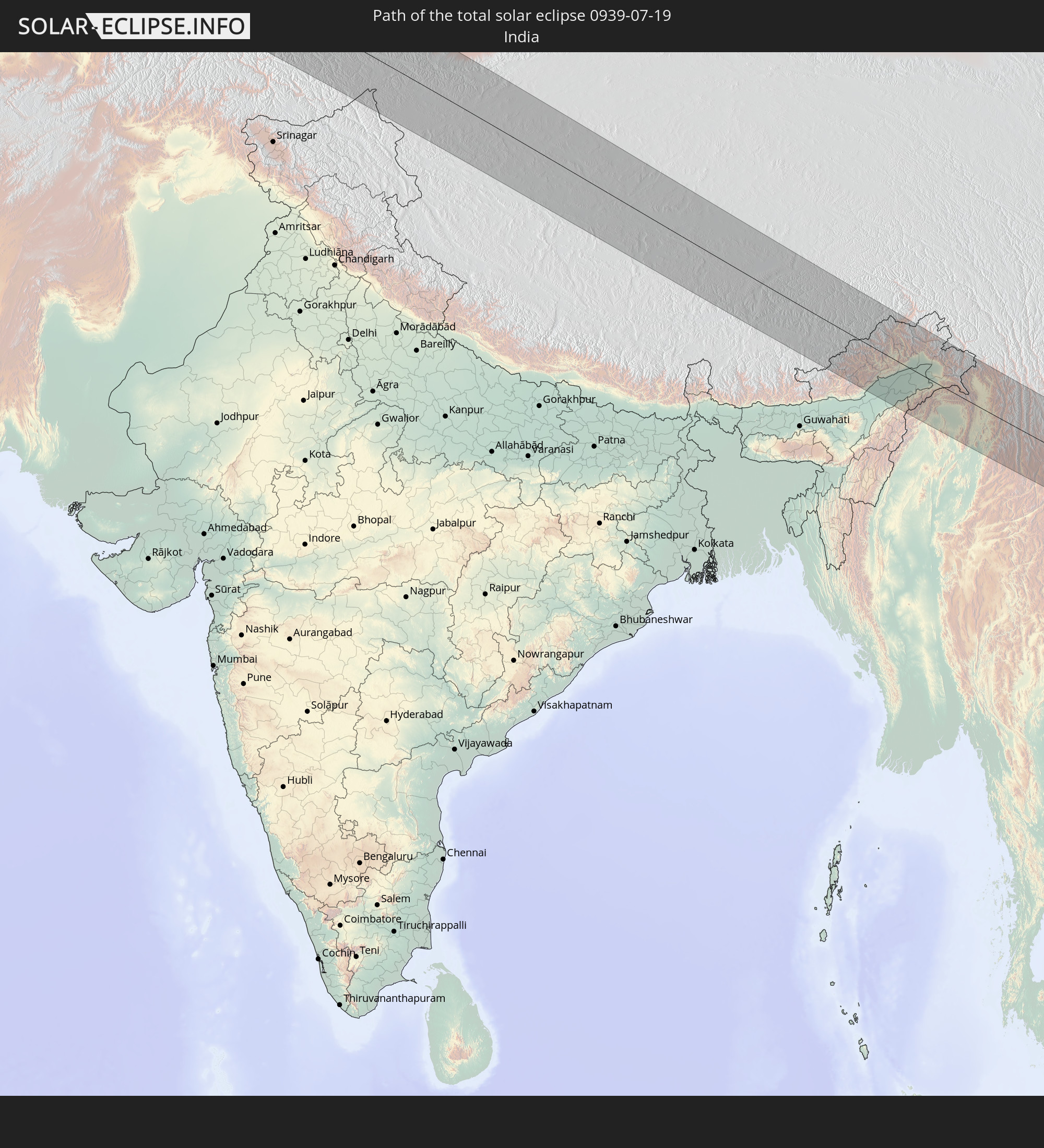 Indien
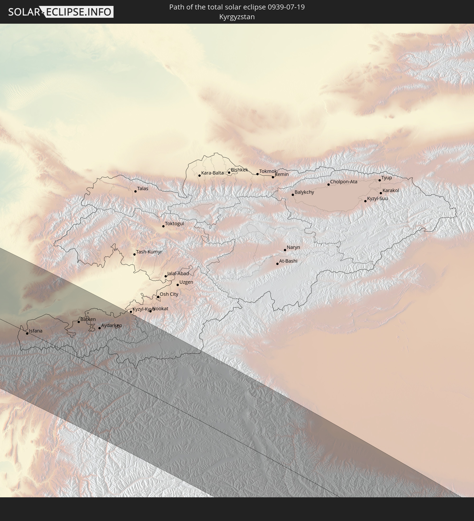 Kirgisistan
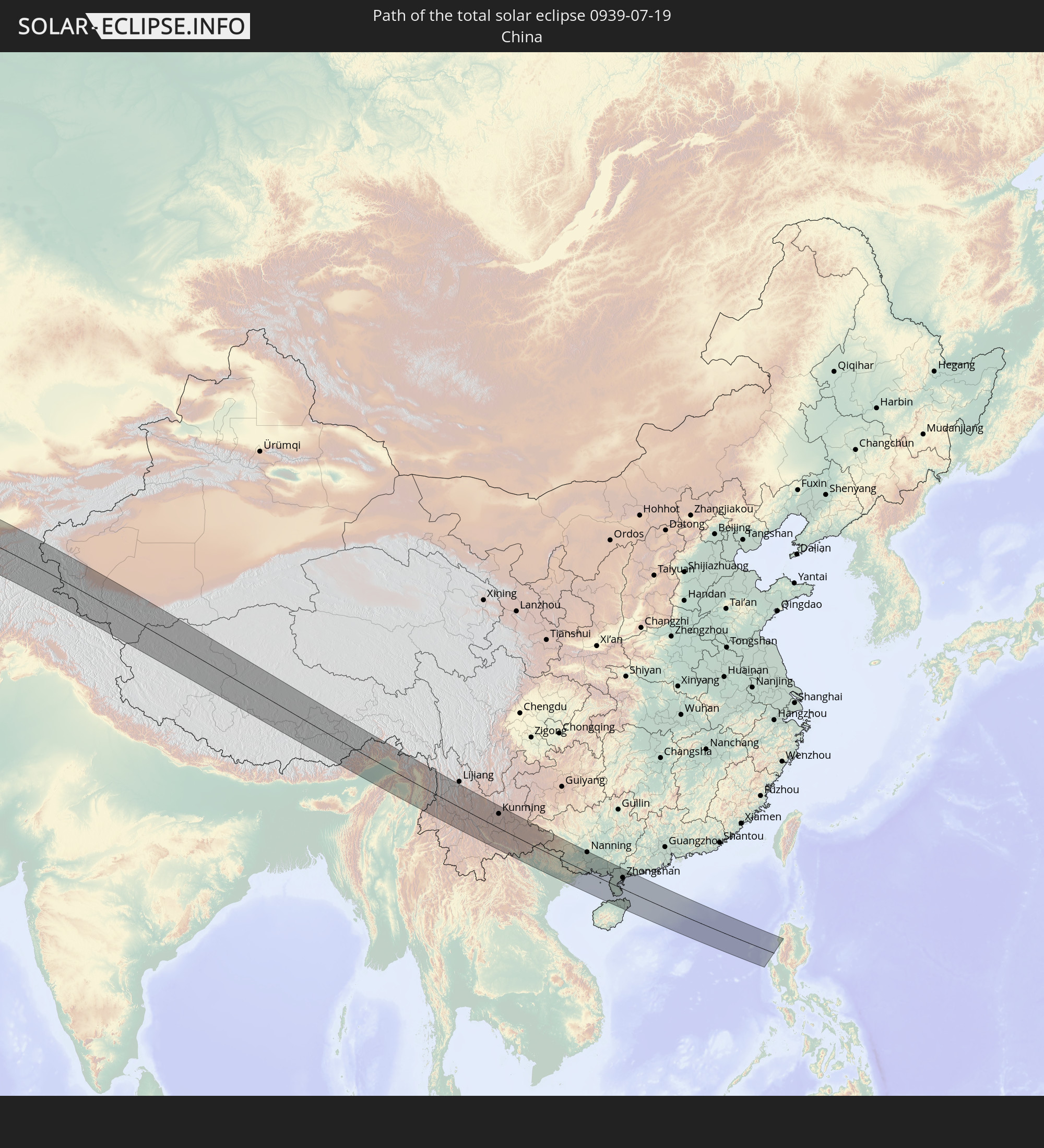 Volksrepublik China
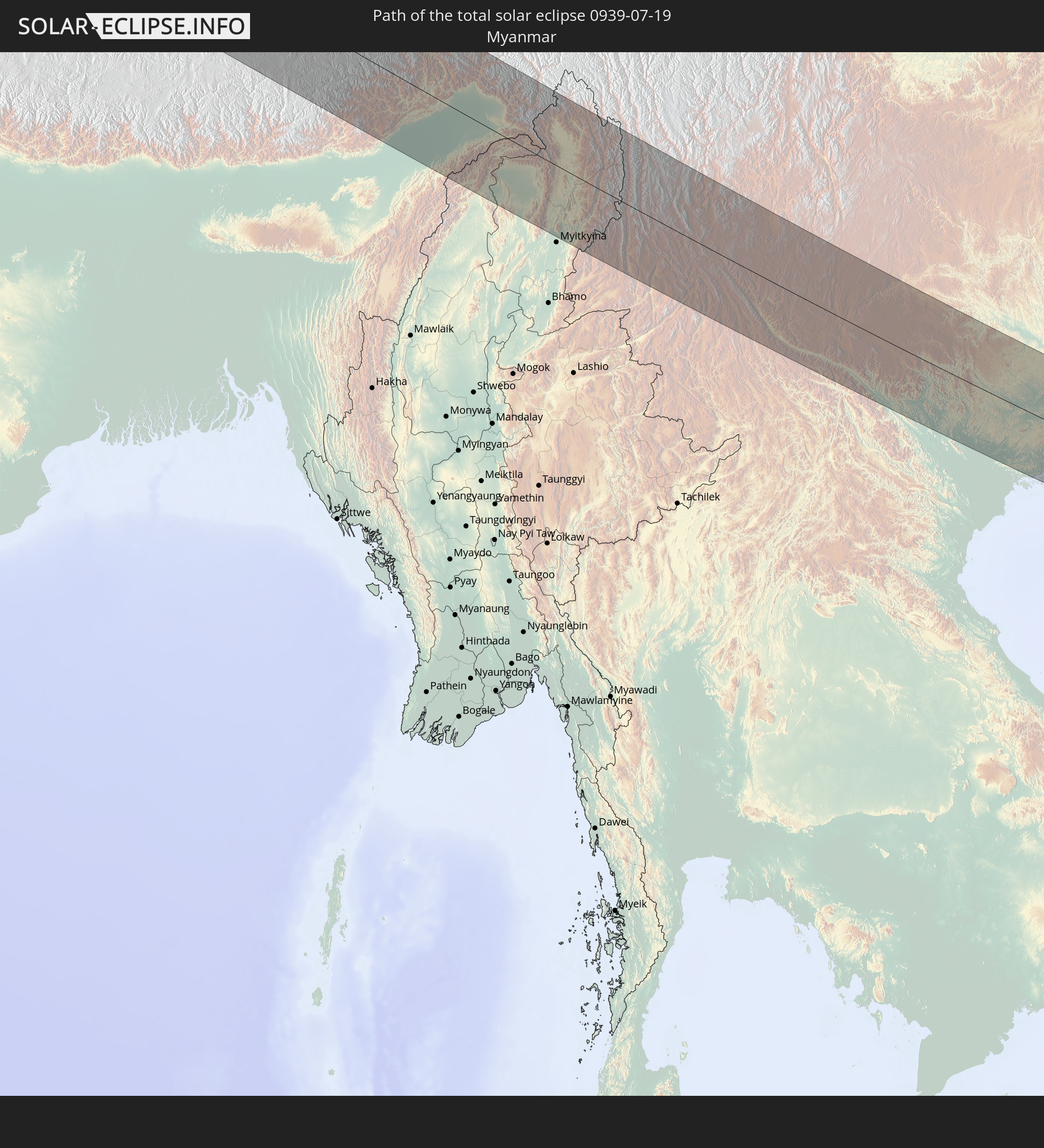 Myanmar
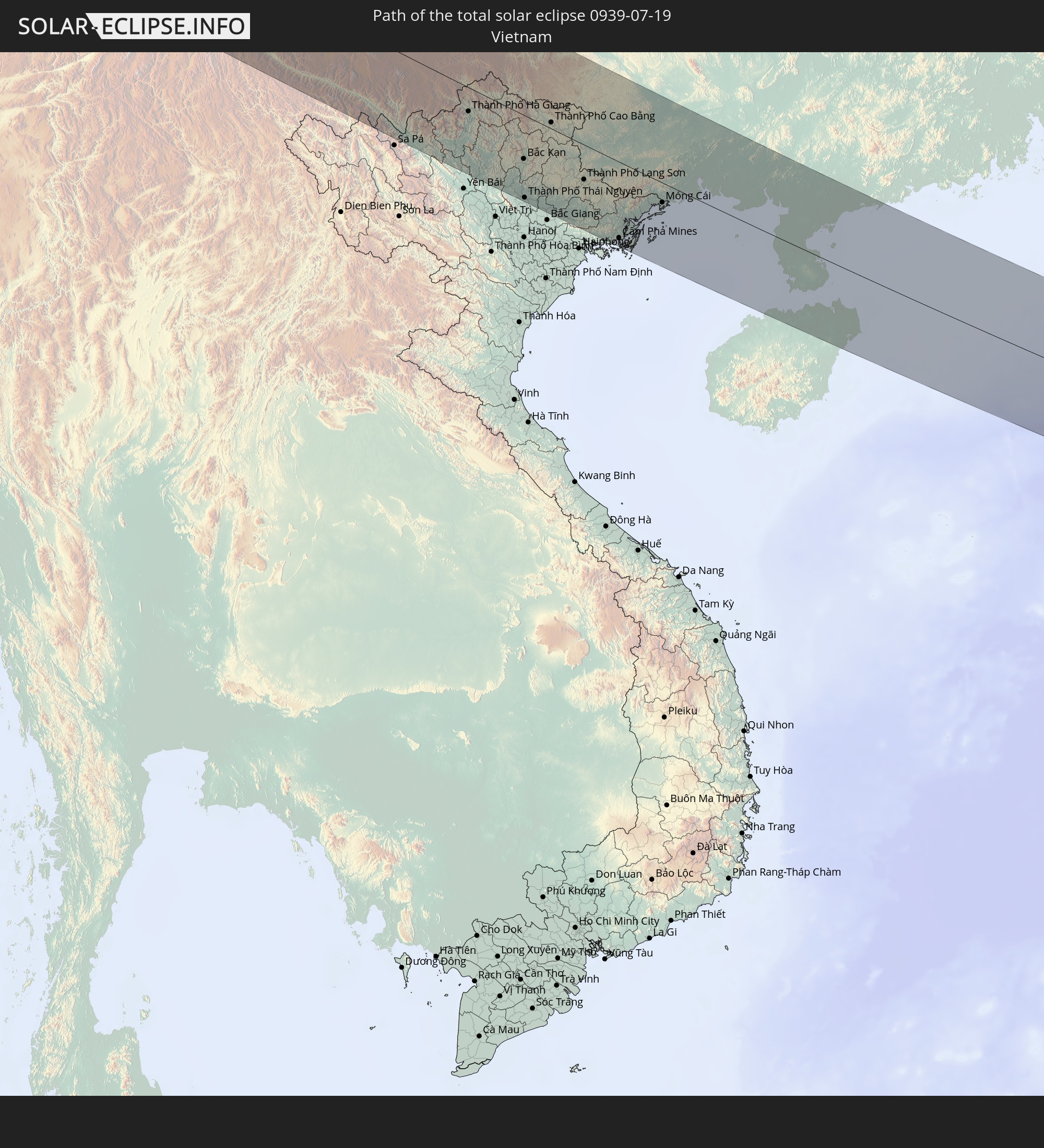 Vietnam
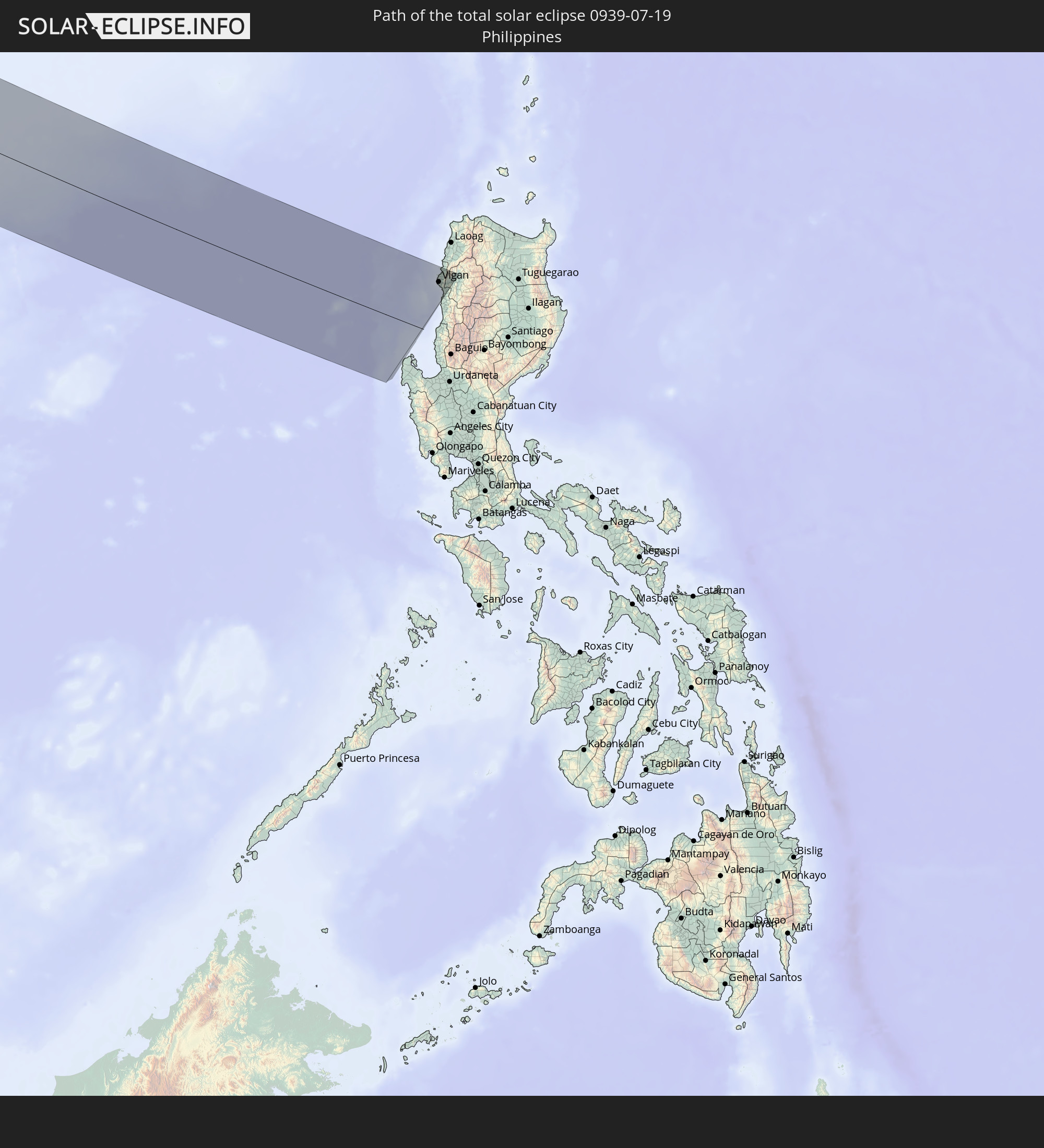 Philippinen
In den folgenden Ländern ist die Sonnenfinsternis partiell zu sehen
 Russland
 Kanada
 Grönland
 Portugal
 Kap Verde
 Island
 Spanien
 Senegal
 Mauretanien
 Gambia
 Guinea-Bissau
 Guinea
 Sierra Leone
 Marokko
 Mali
Mali
 Liberia
 Irland
 Spitzbergen
 Algerien
 Vereinigtes Königreich
 Elfenbeinküste
 Färöer
 Burkina Faso
 Gibraltar
 Frankreich
 Isle of Man
 Ghana
Ghana
 Guernsey
 Jersey
 Togo
Togo
 Niger
Niger
 Benin
Benin
 Andorra
 Belgien
 Nigeria
 Niederlande
 Norwegen
 Luxemburg
 Deutschland
 Schweiz
 Italien
 Monaco
 Tunesien
 Dänemark
 Kamerun
 Libyen
 Liechtenstein
 Österreich
 Schweden
 Tschechien
 San Marino
 Vatikanstadt
 Slowenien
 Tschad
 Kroatien
 Polen
Polen
 Malta
Malta
 Bosnien und Herzegowina
 Ungarn
 Slowakei
 Montenegro
 Serbien
 Albanien
 Åland Islands
 Griechenland
 Rumänien
 Mazedonien
 Finnland
 Litauen
 Lettland
 Estland
 Sudan
Sudan
 Ukraine
 Bulgarien
 Weißrussland
 Ägypten
 Türkei
 Moldawien
 Republik Zypern
 Staat Palästina
 Israel
 Saudi-Arabien
 Jordanien
 Libanon
 Syrien
 Eritrea
 Irak
Irak
 Georgien
 Jemen
Jemen
 Armenien
 Iran
Iran
 Aserbaidschan
 Kasachstan
 Kuwait
 Bahrain
 Katar
Katar
 Vereinigte Arabische Emirate
 Oman
Oman
 Turkmenistan
 Usbekistan
 Afghanistan
 Pakistan
 Tadschikistan
 Indien
 Kirgisistan
 Malediven
 Volksrepublik China
 Sri Lanka
 Nepal
Nepal
 Mongolei
 Bangladesch
 Bhutan
 Myanmar
 Indonesien
 Thailand
 Malaysia
 Laos
Laos
 Vietnam
 Kambodscha
 Singapur
 Weihnachtsinsel
 Macau
Macau
 Hongkong
 Taiwan
 Philippinen
 Japan
Japan
 Nordkorea
 Südkorea
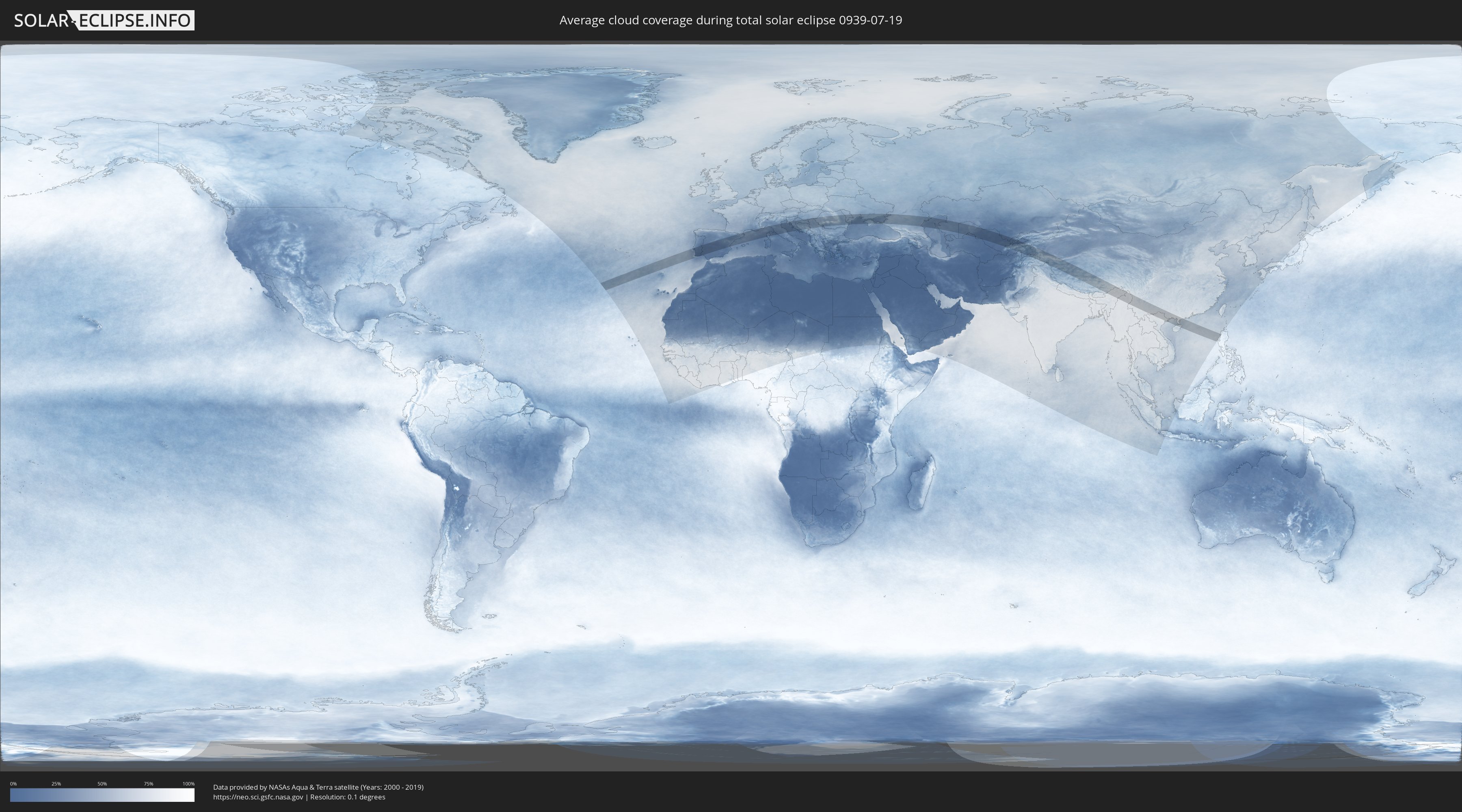
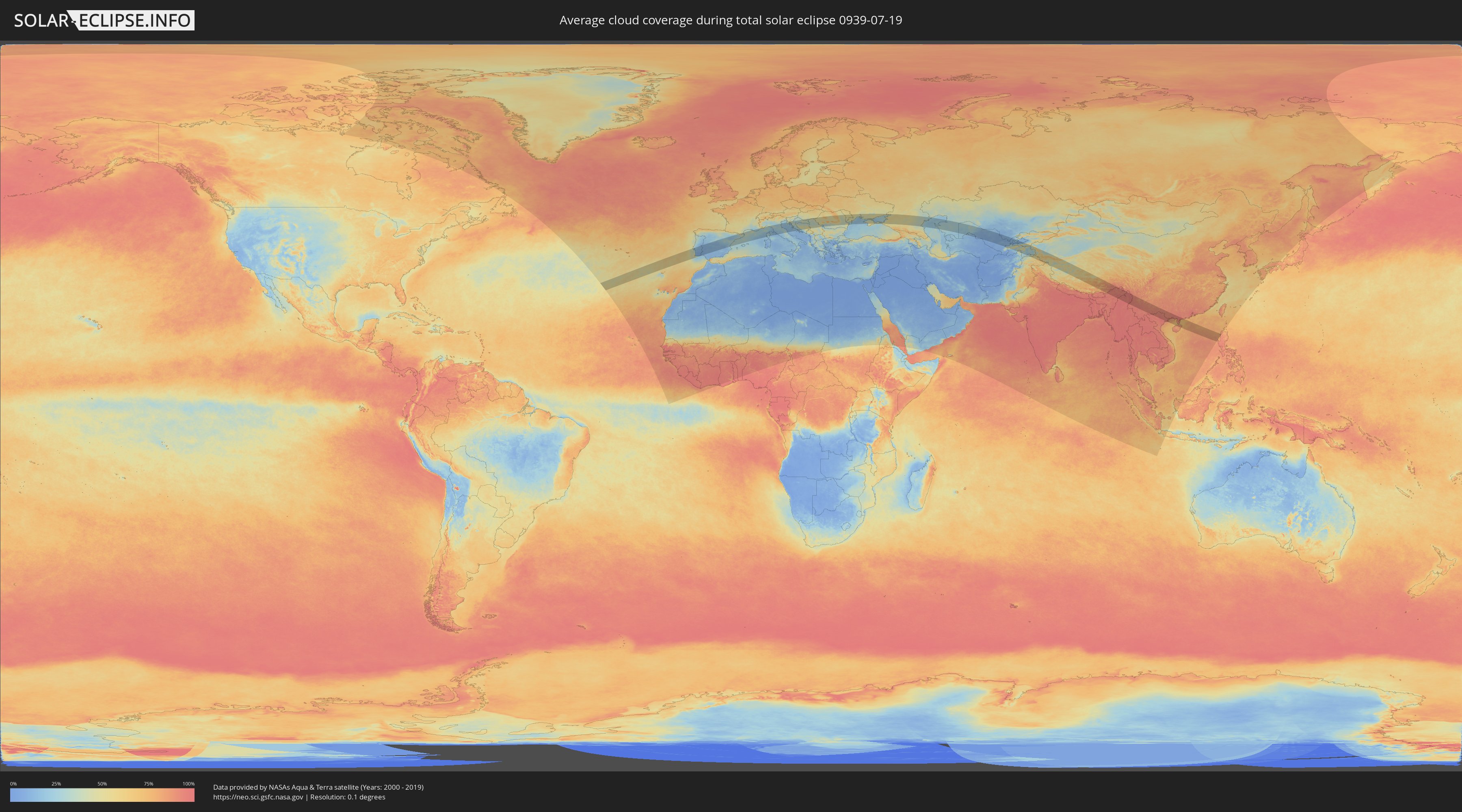
Wie wird das Wetter während der totalen Sonnenfinsternis am 19.07.0939?
Wo ist der beste Ort, um die totale Sonnenfinsternis vom 19.07.0939 zu beobachten?
Die folgenden Karten zeigen die durchschnittliche Bewölkung für den Tag, an dem die totale Sonnenfinsternis
stattfindet. Mit Hilfe der Karten lässt sich der Ort entlang des Finsternispfades eingrenzen,
der die besten Aussichen auf einen klaren wolkenfreien Himmel bietet.
Trotzdem muss man immer lokale Gegenenheiten beachten und sollte sich genau über das Wetter an seinem
gewählten Beobachtungsort informieren.
Die Daten stammen von den beiden NASA-Satelliten
AQUA und TERRA
und wurden über einen Zeitraum von 19 Jahren (2000 - 2019) gemittelt.
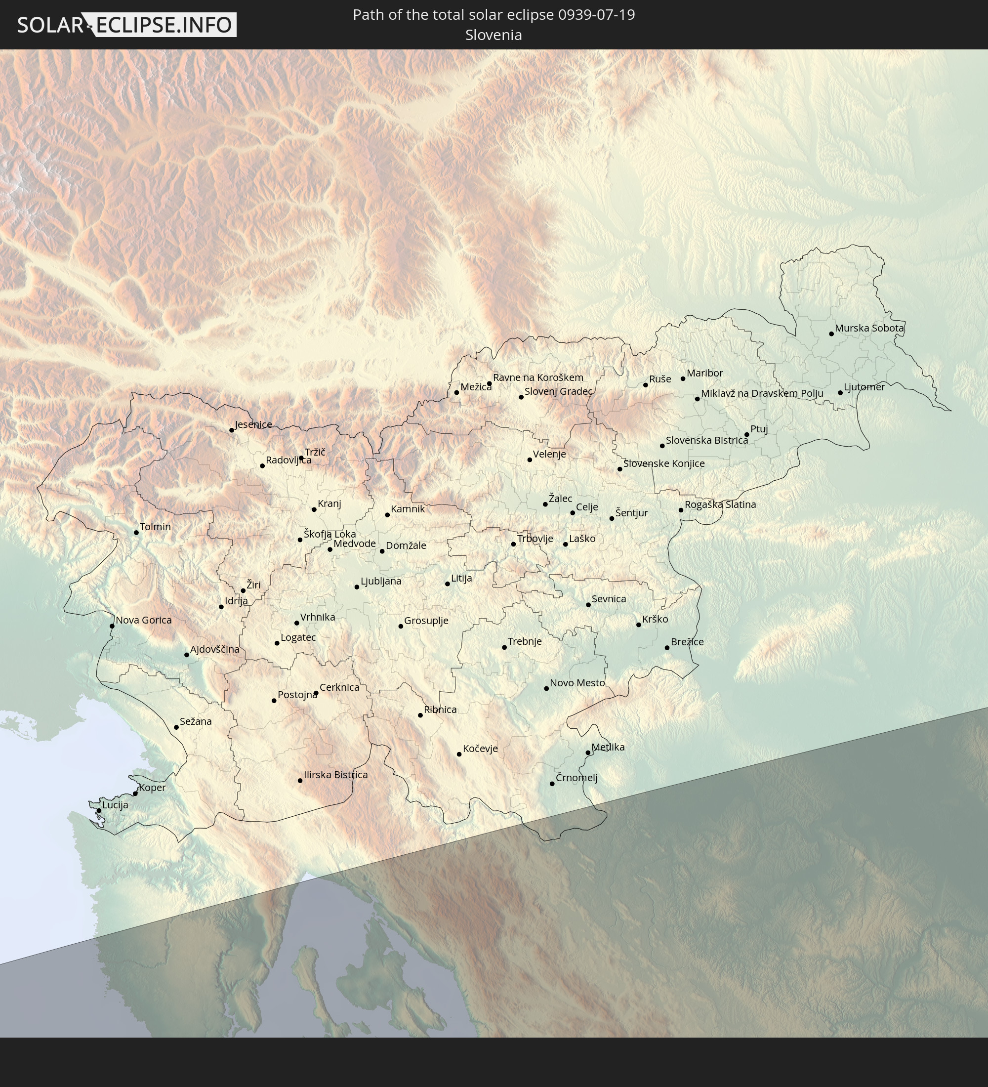
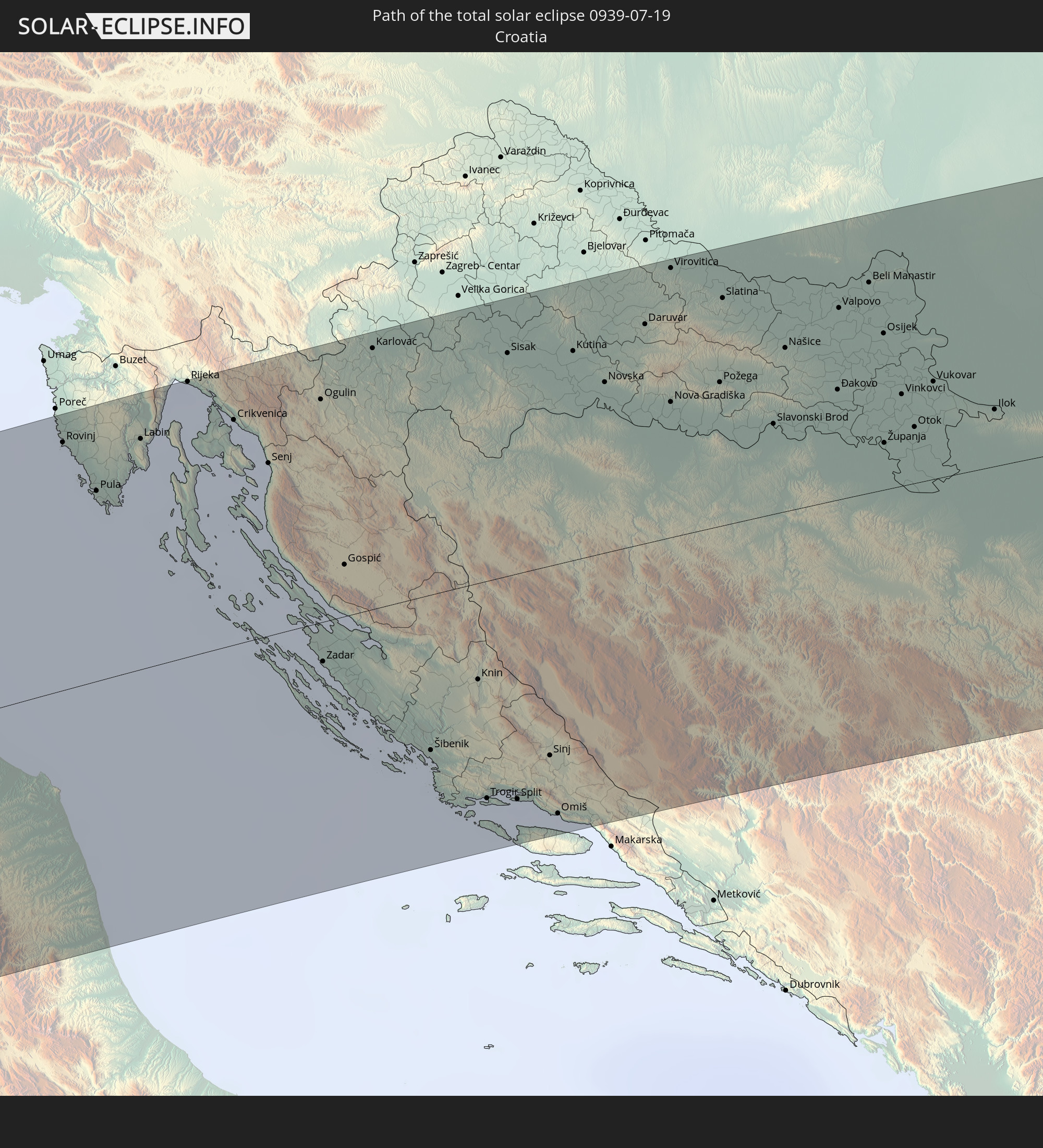
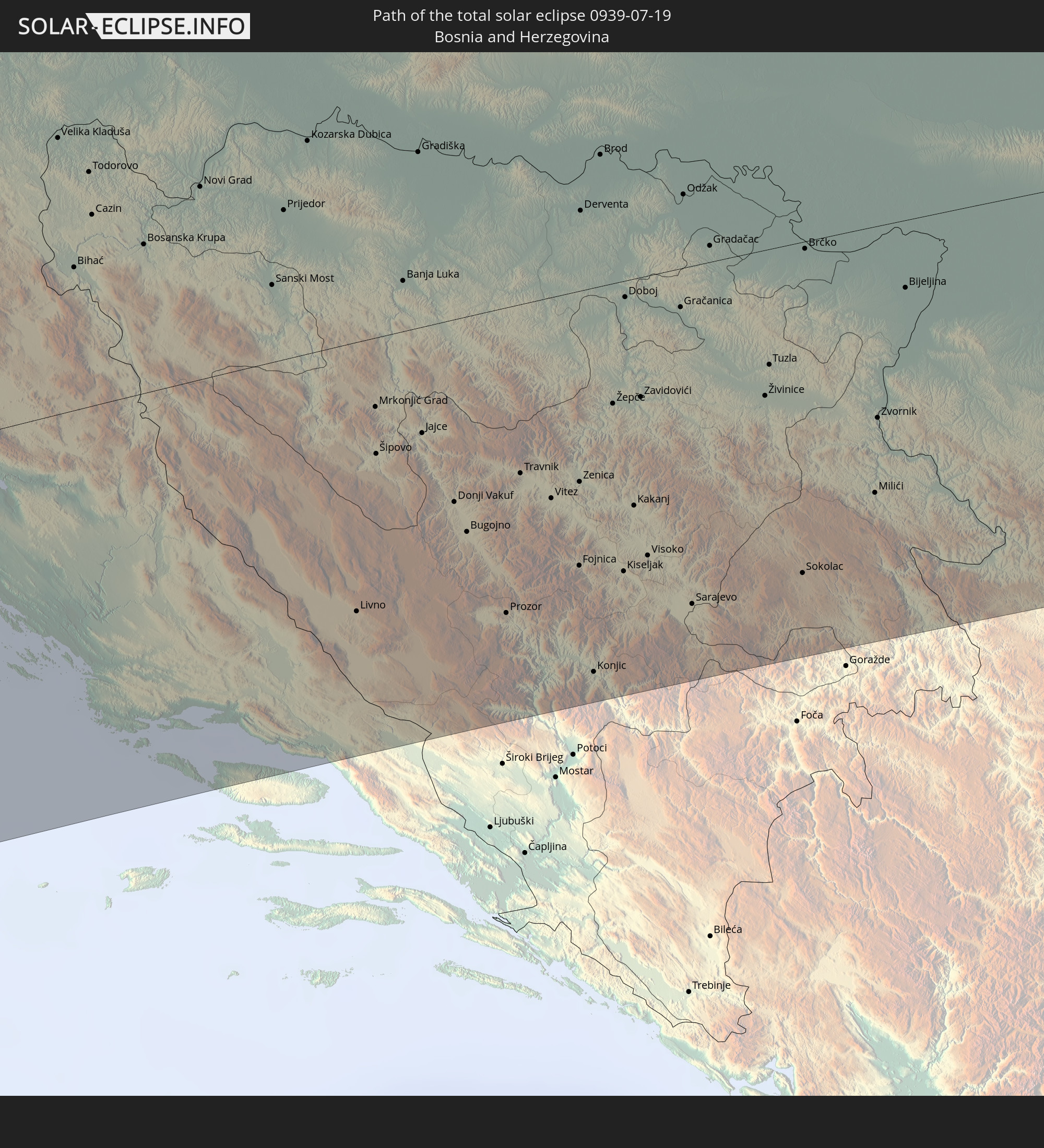
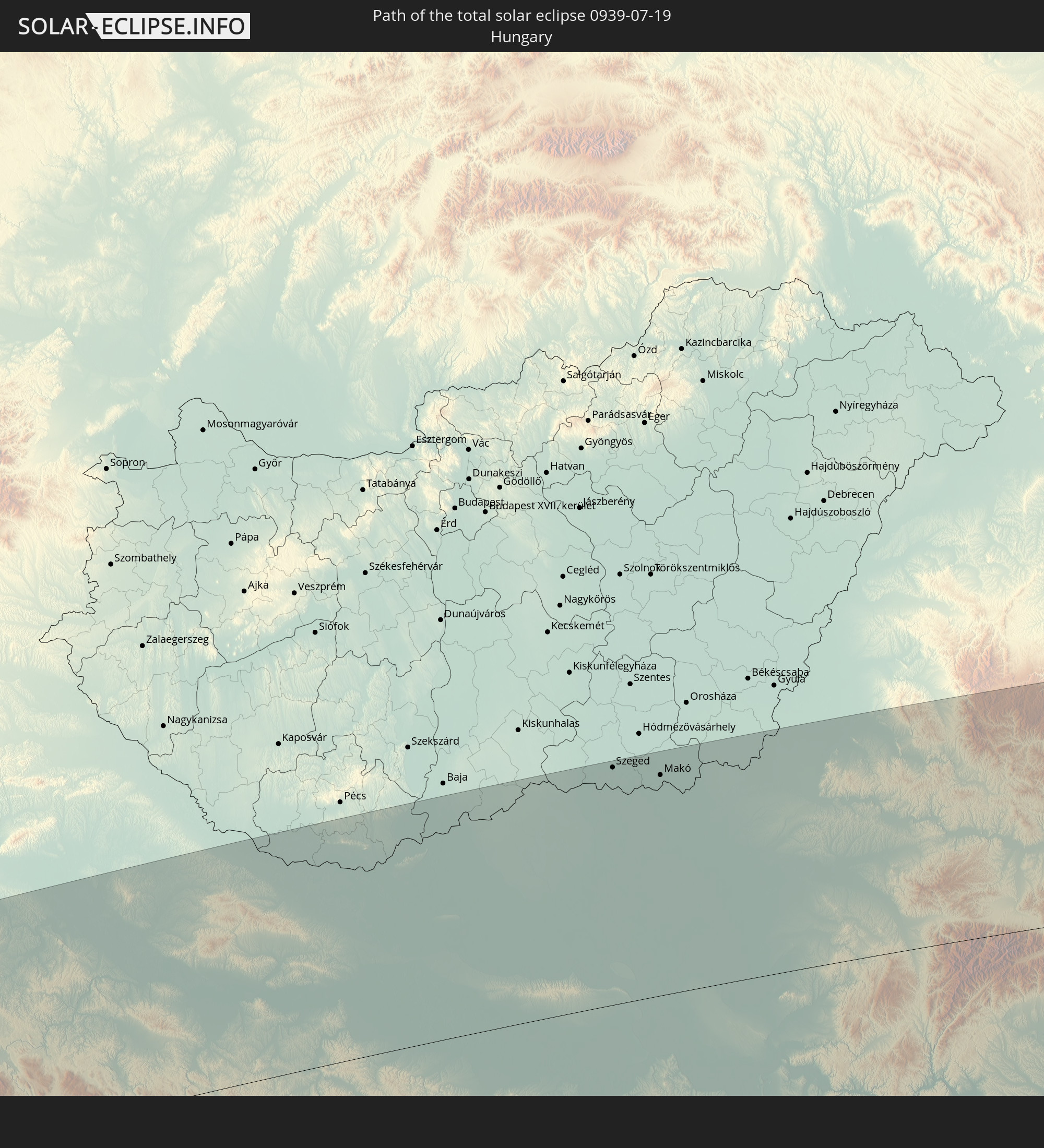
Detaillierte Länderkarten
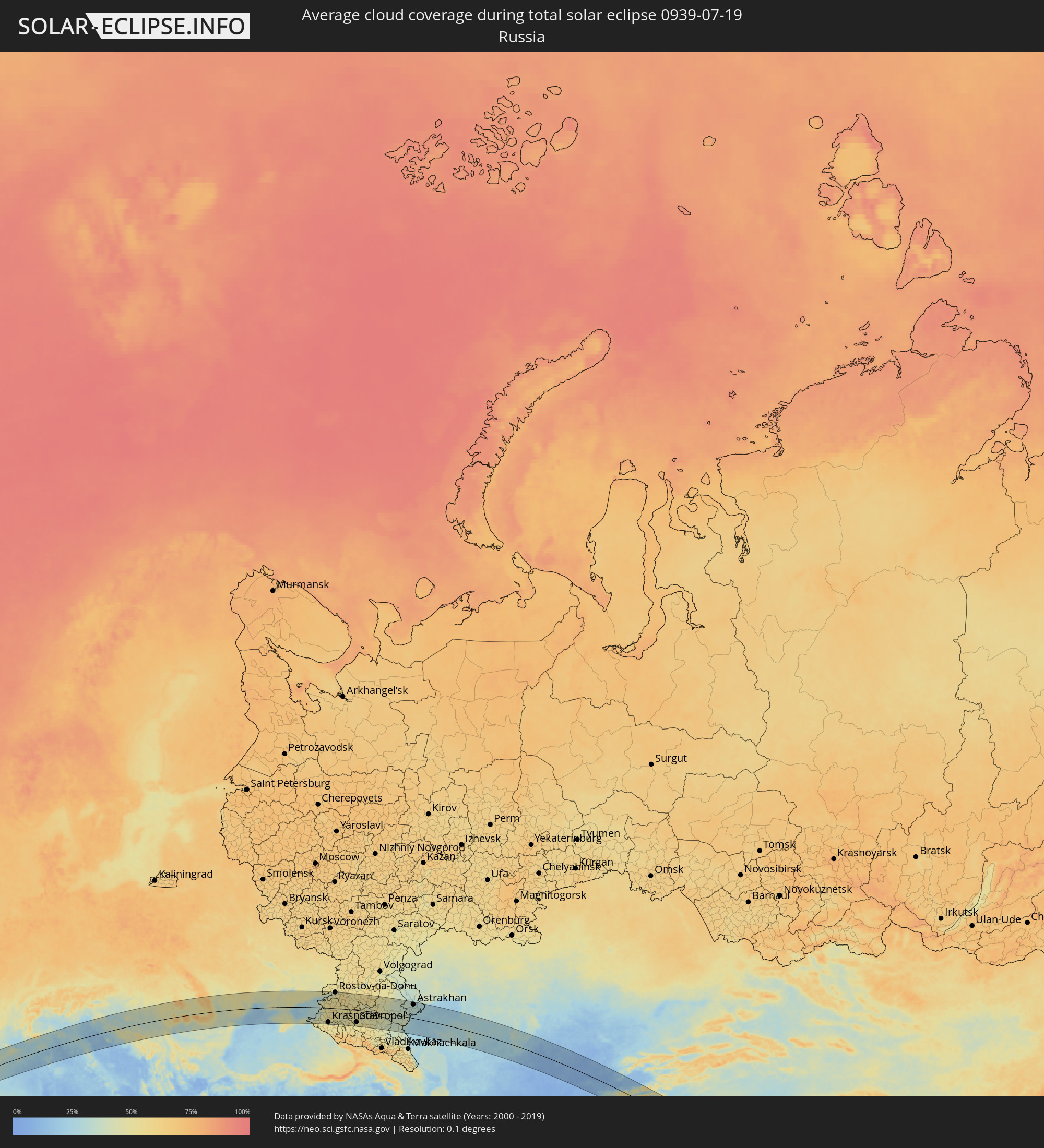 Russland
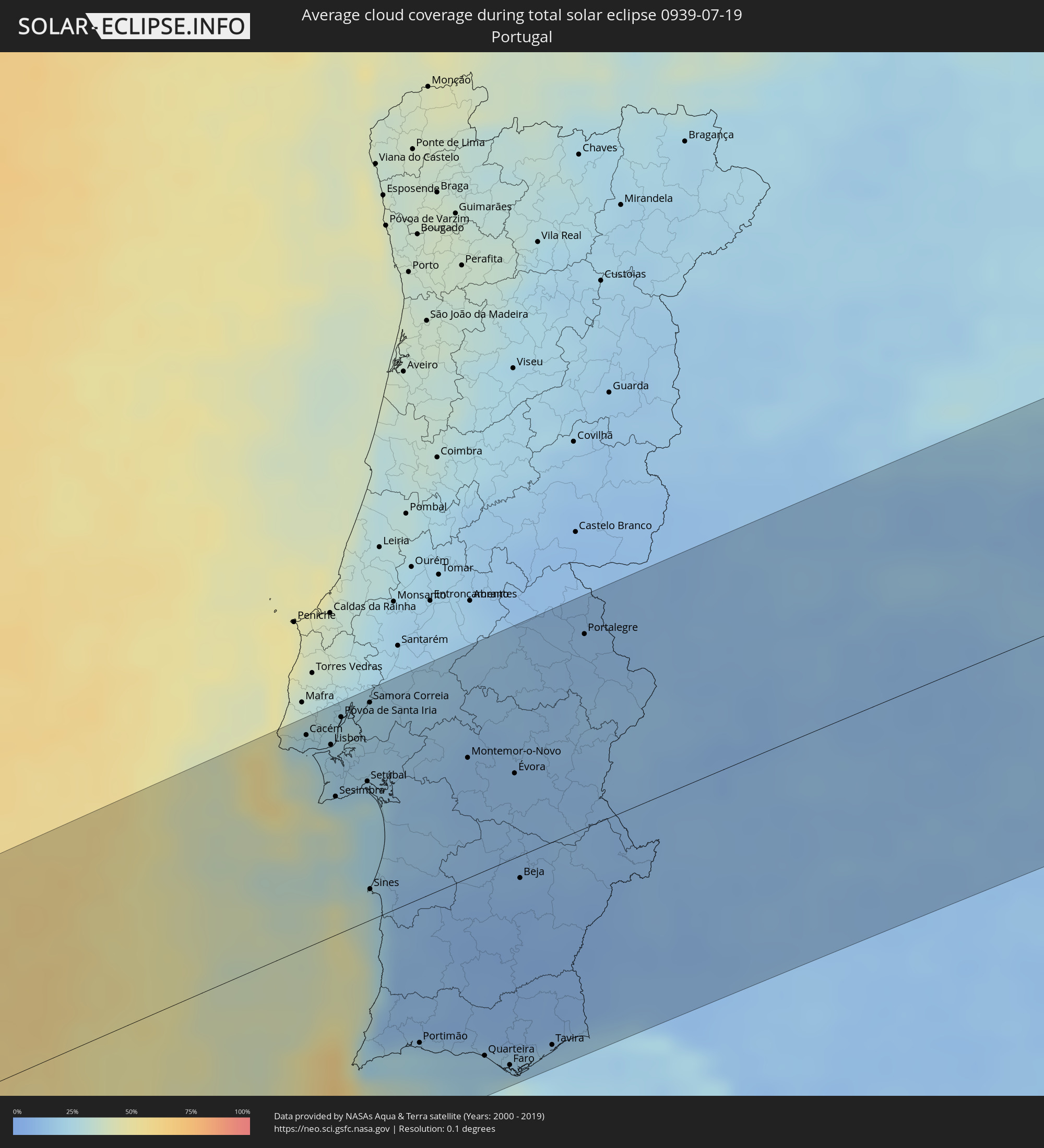 Portugal
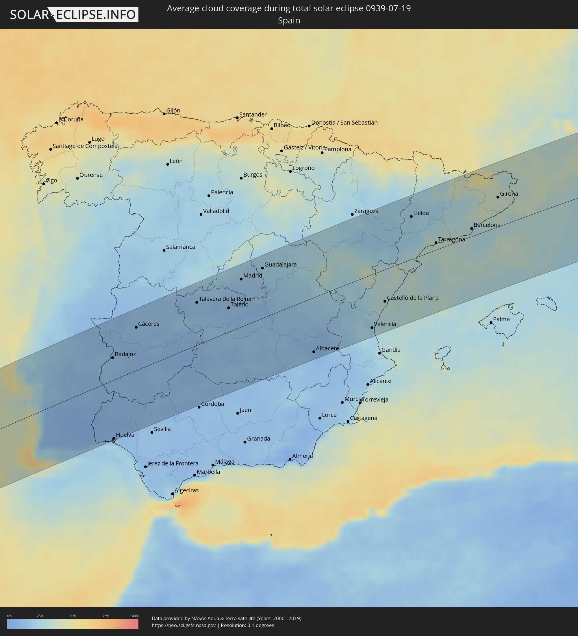 Spanien
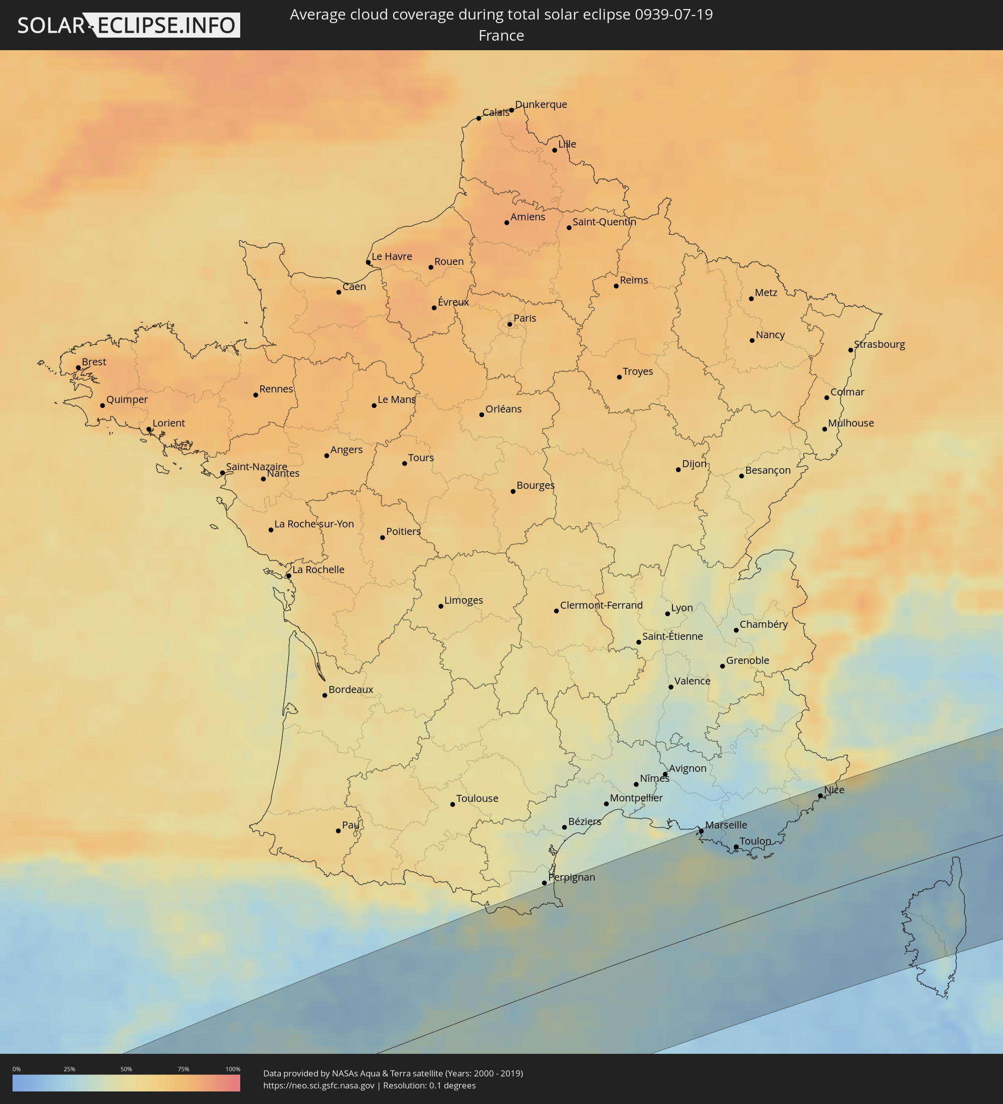 Frankreich
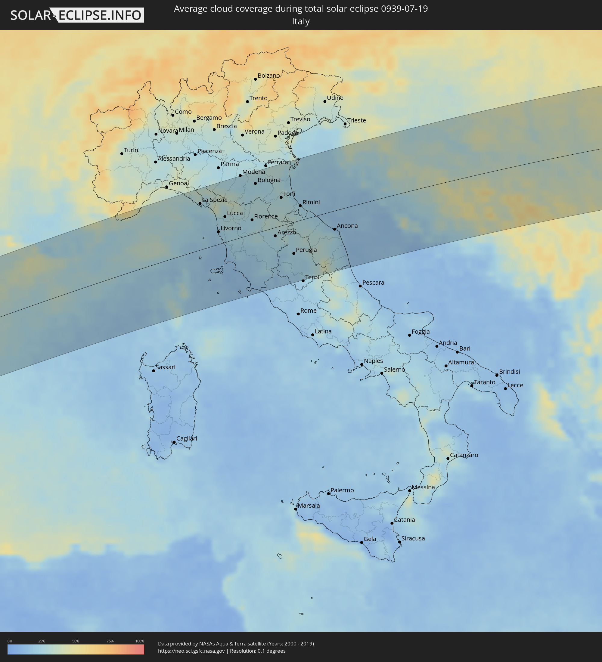 Italien
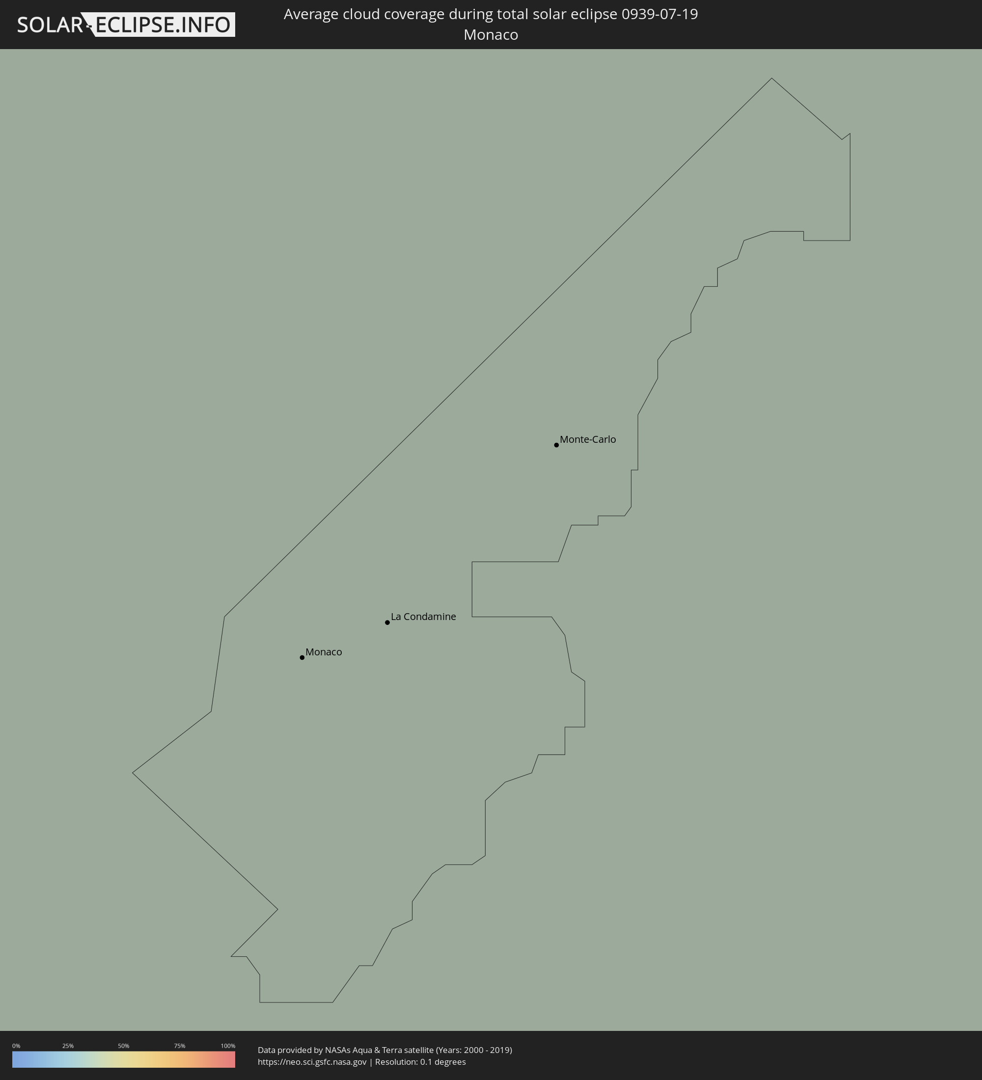 Monaco
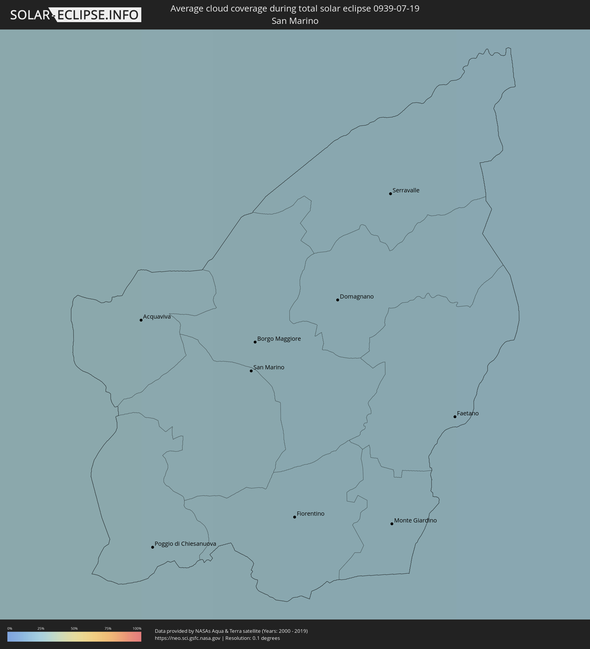 San Marino
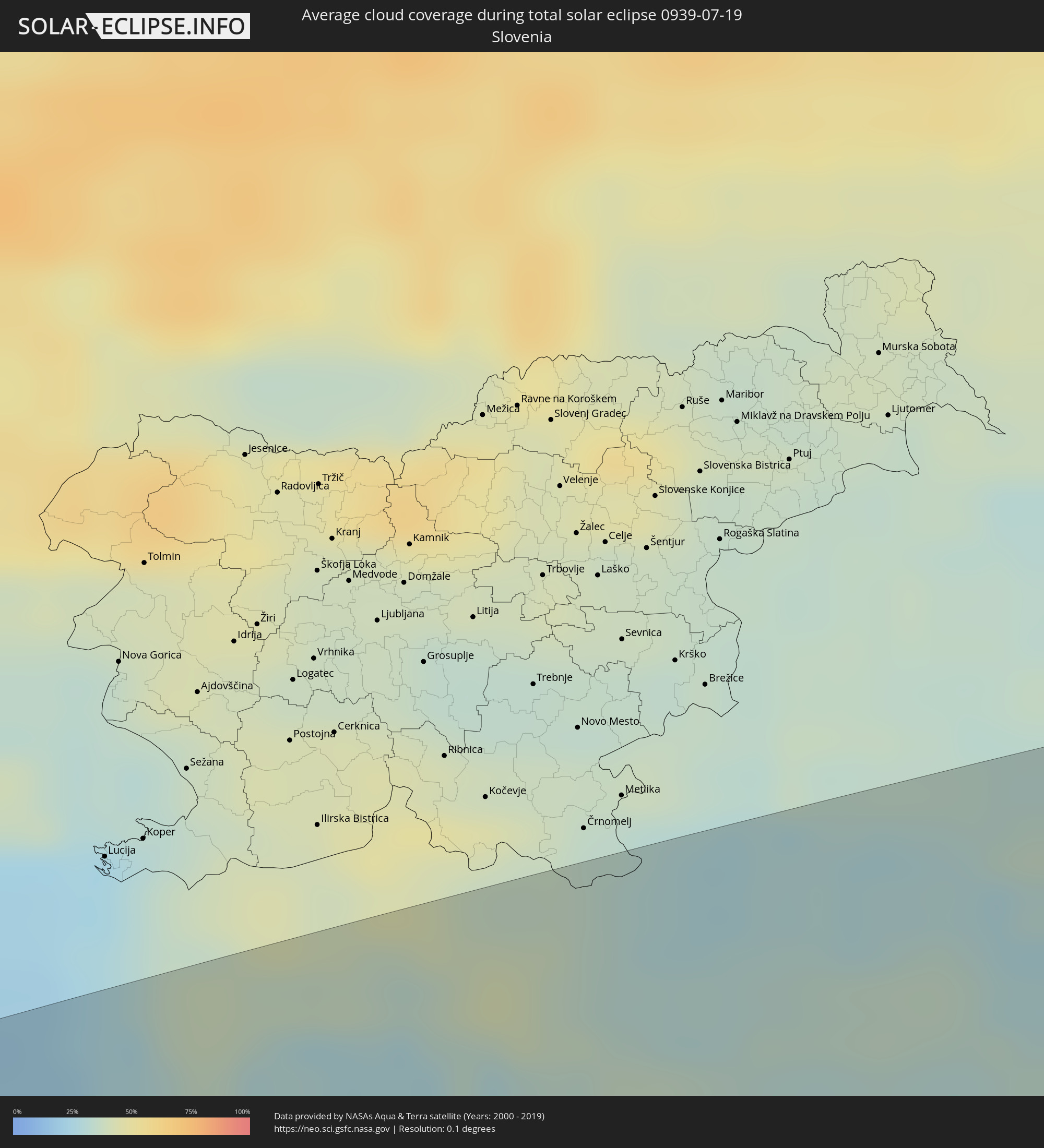 Slowenien
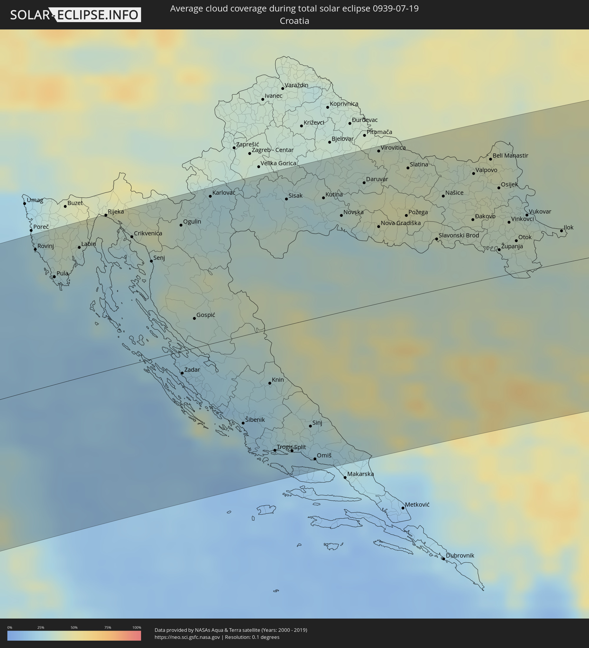 Kroatien
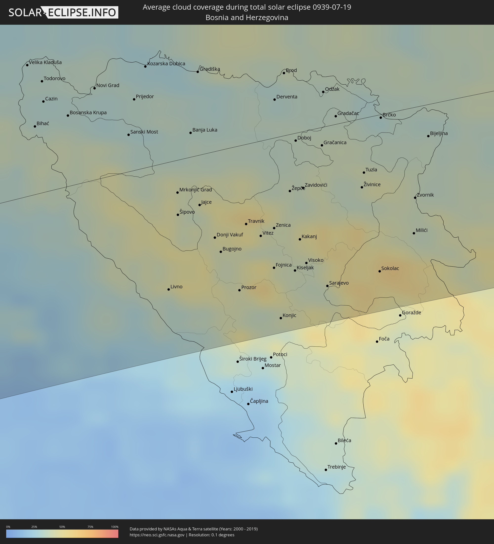 Bosnien und Herzegowina
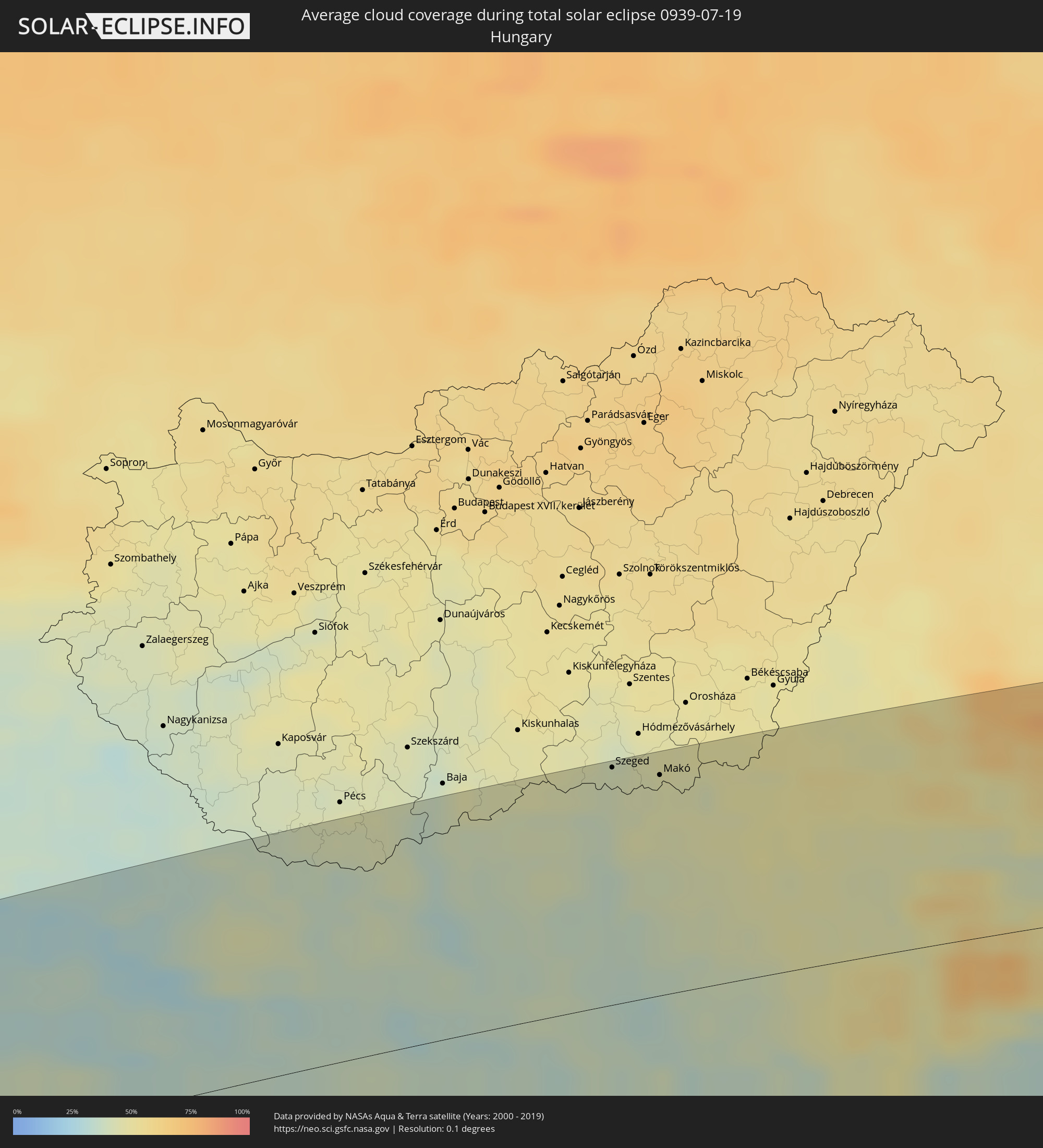 Ungarn
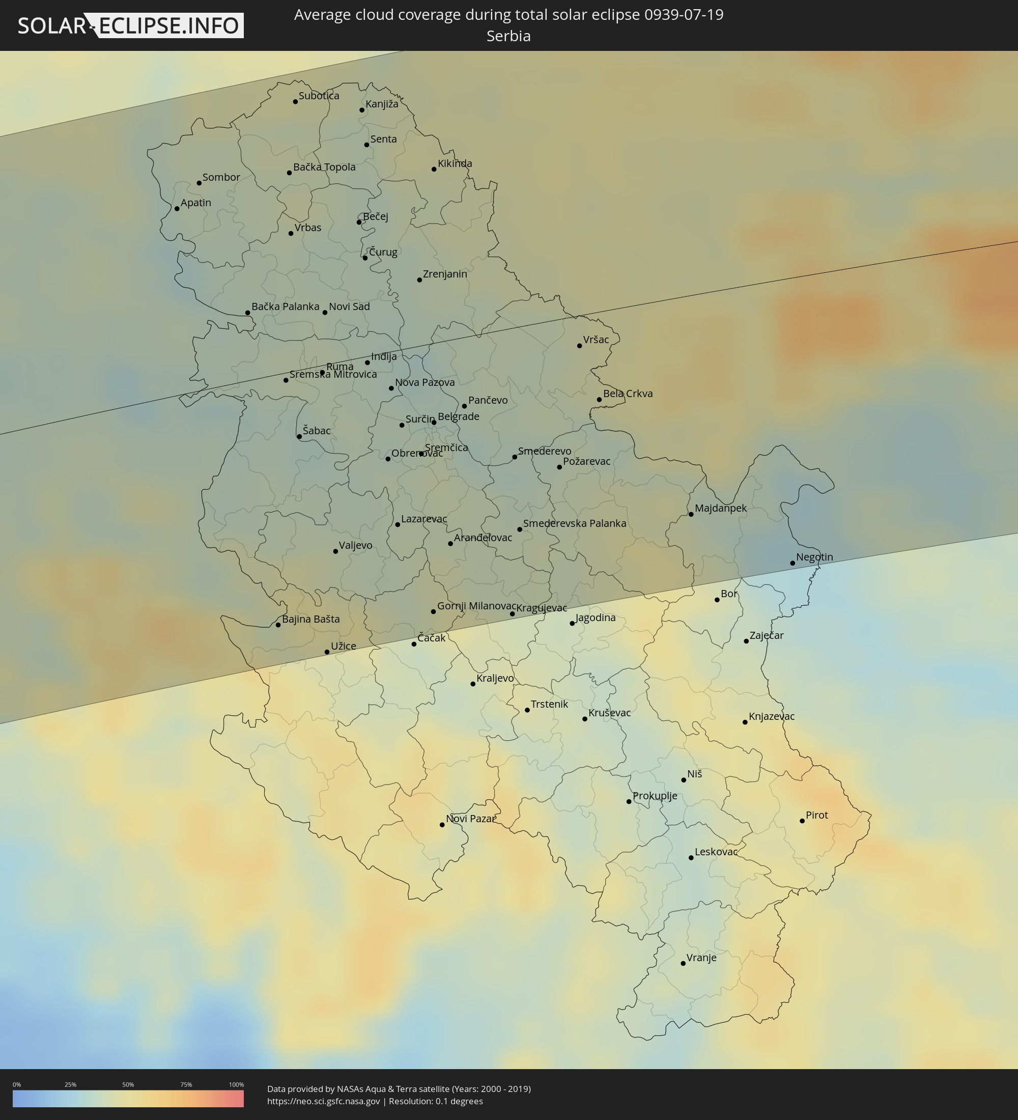 Serbien
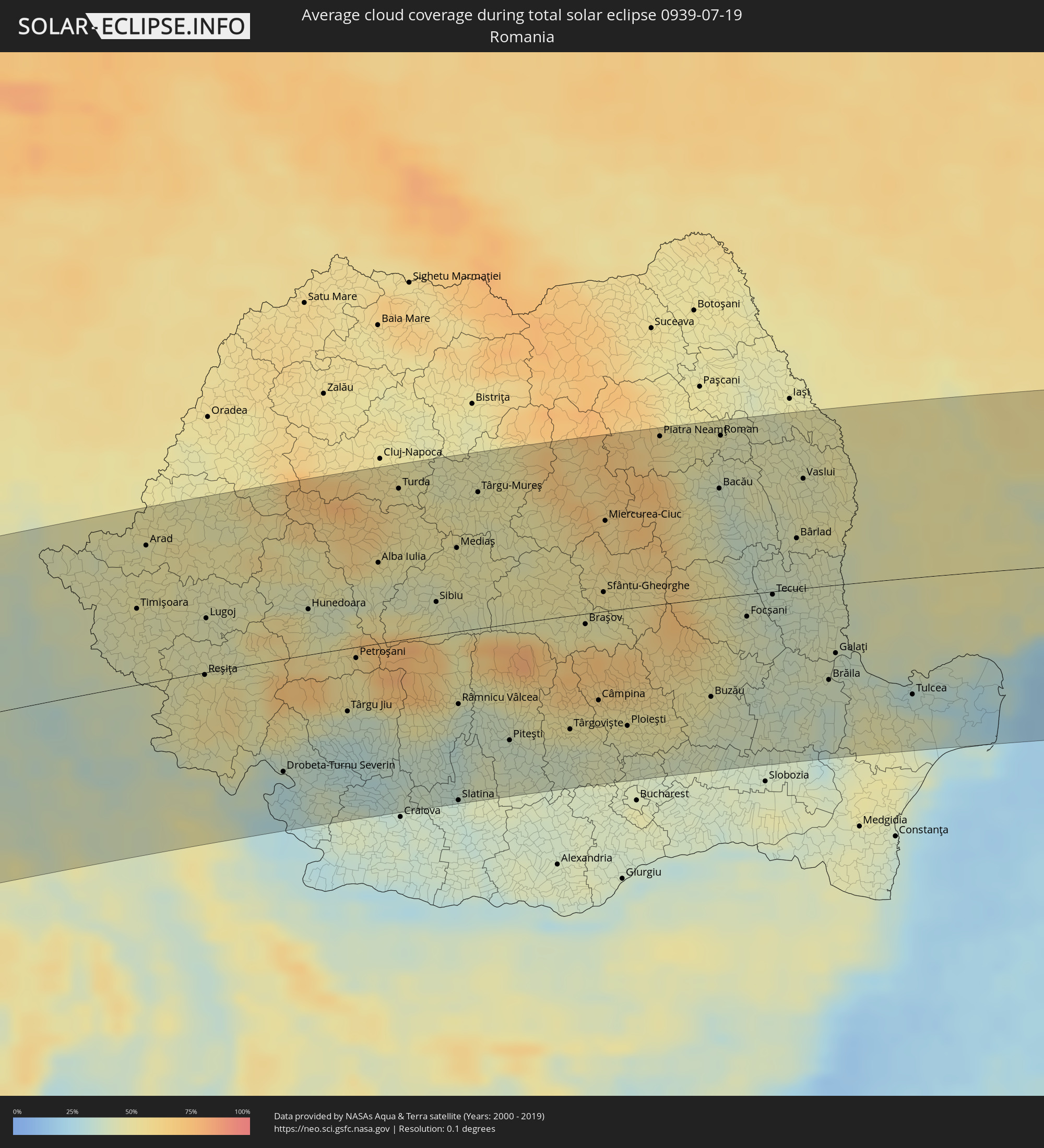 Rumänien
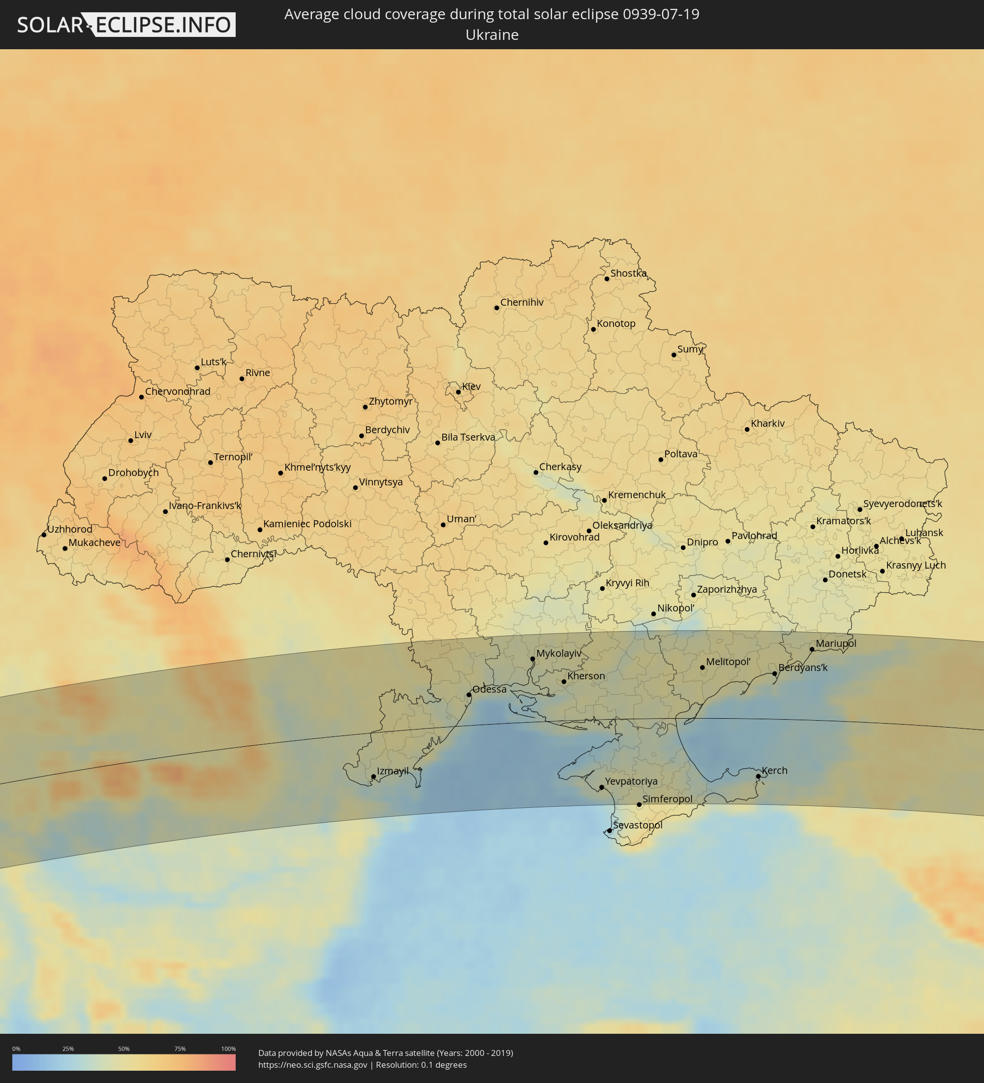 Ukraine
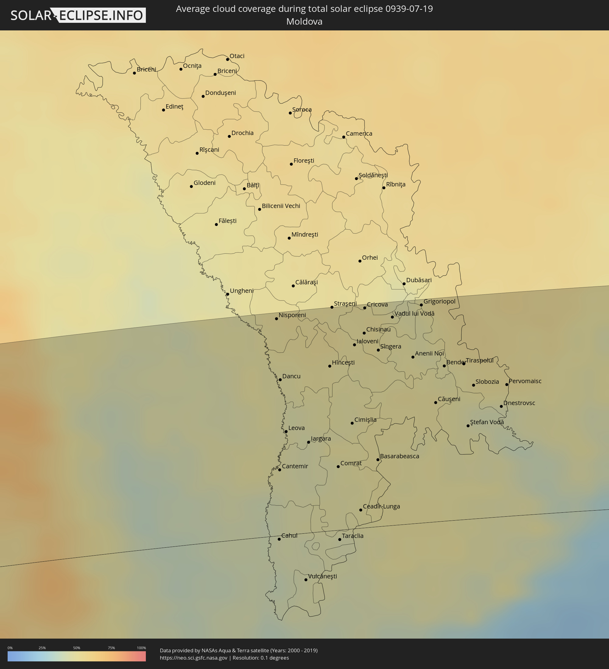 Moldawien
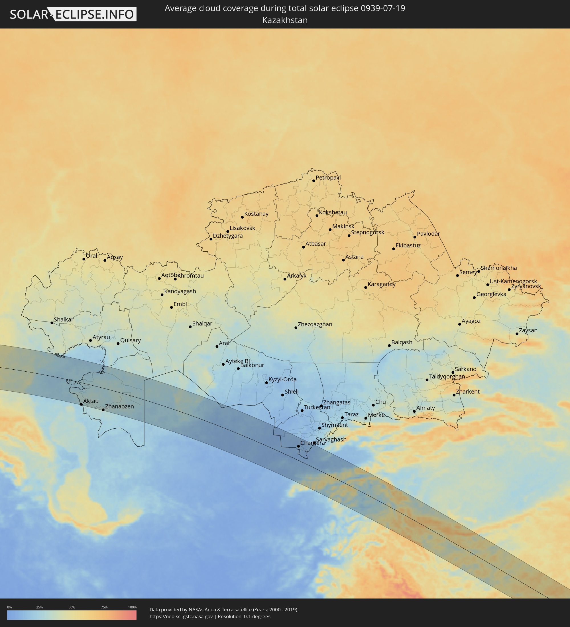 Kasachstan
 Turkmenistan
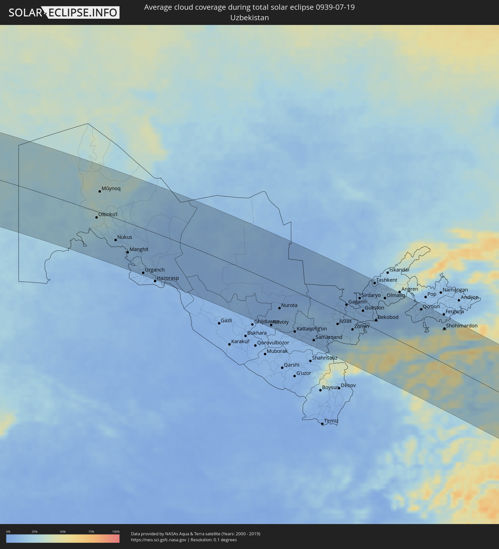 Usbekistan
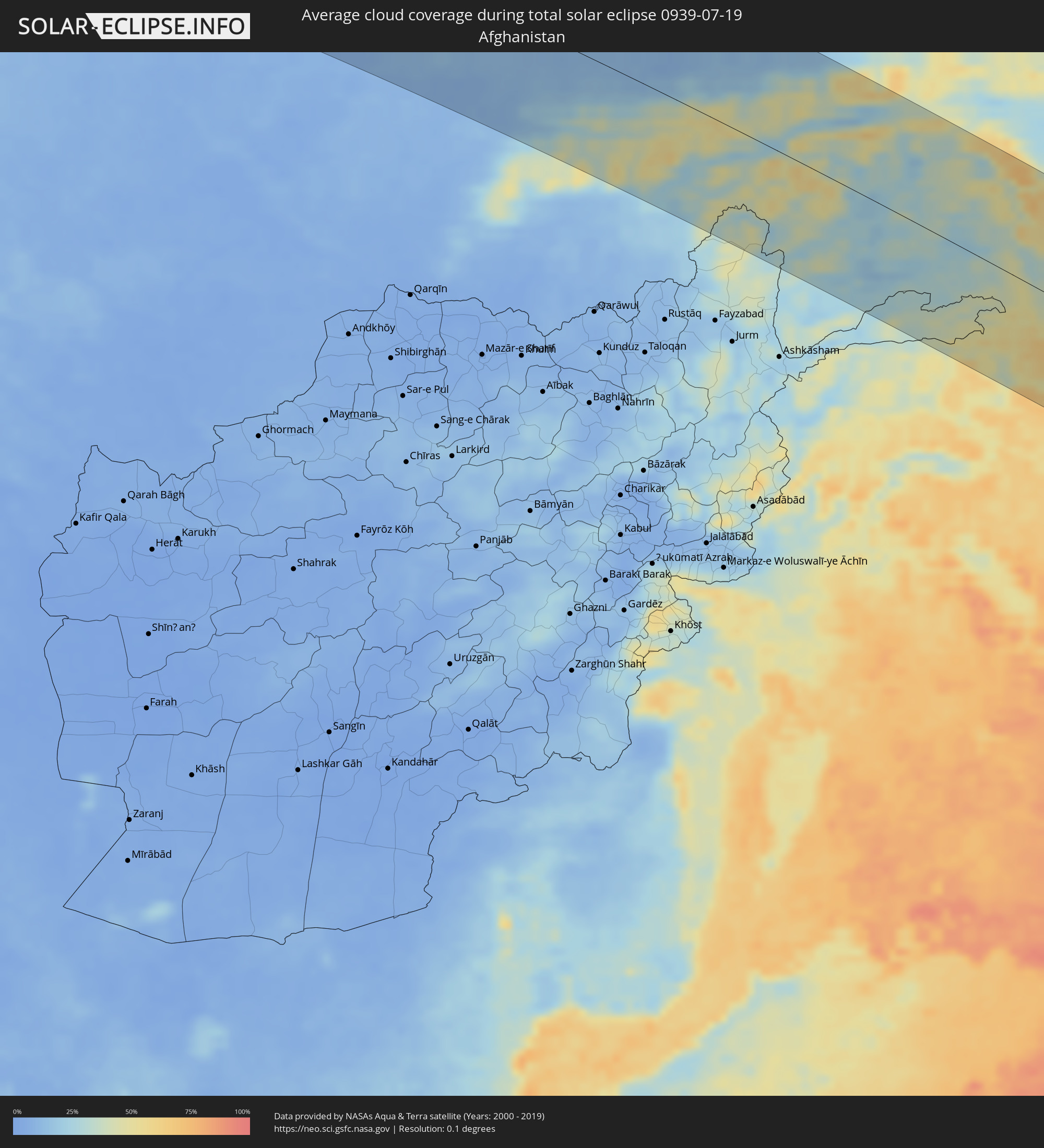 Afghanistan
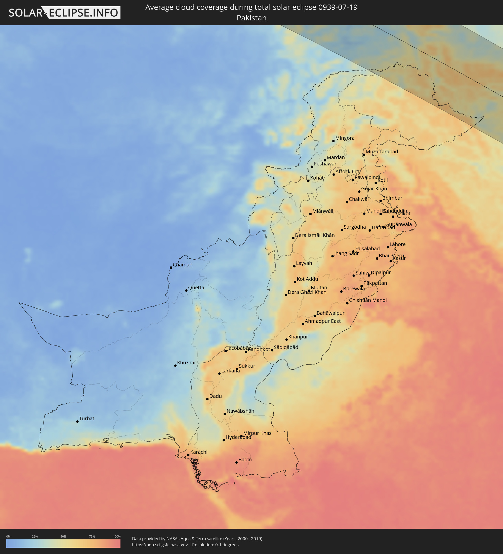 Pakistan
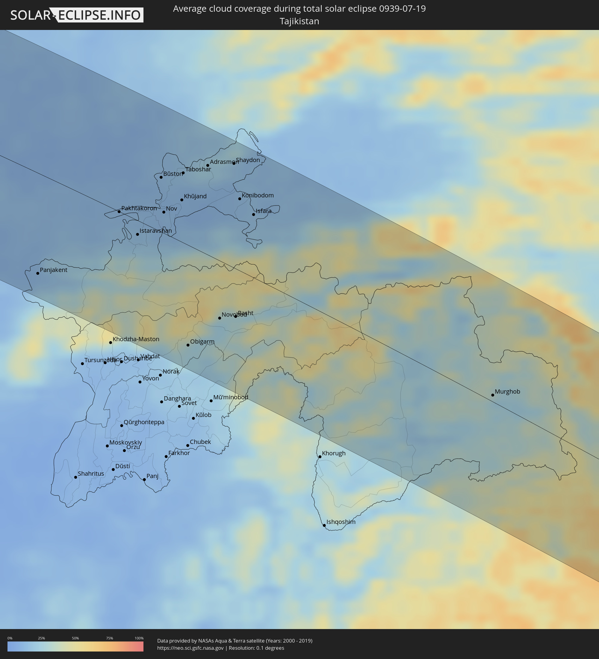 Tadschikistan
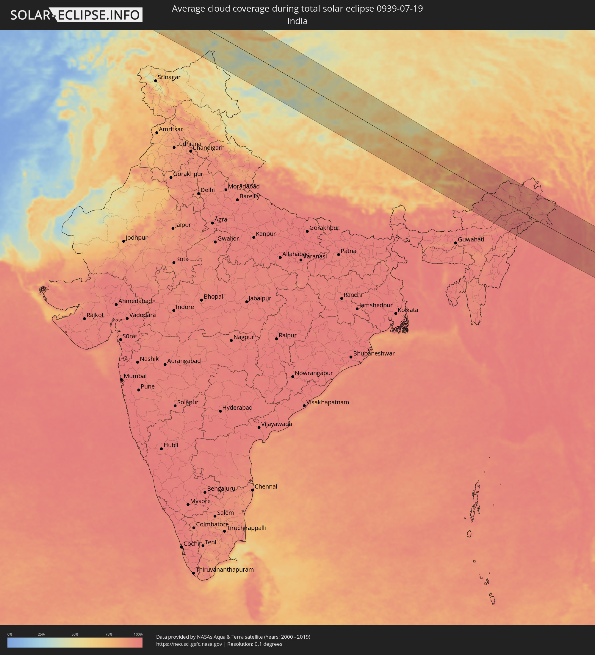 Indien
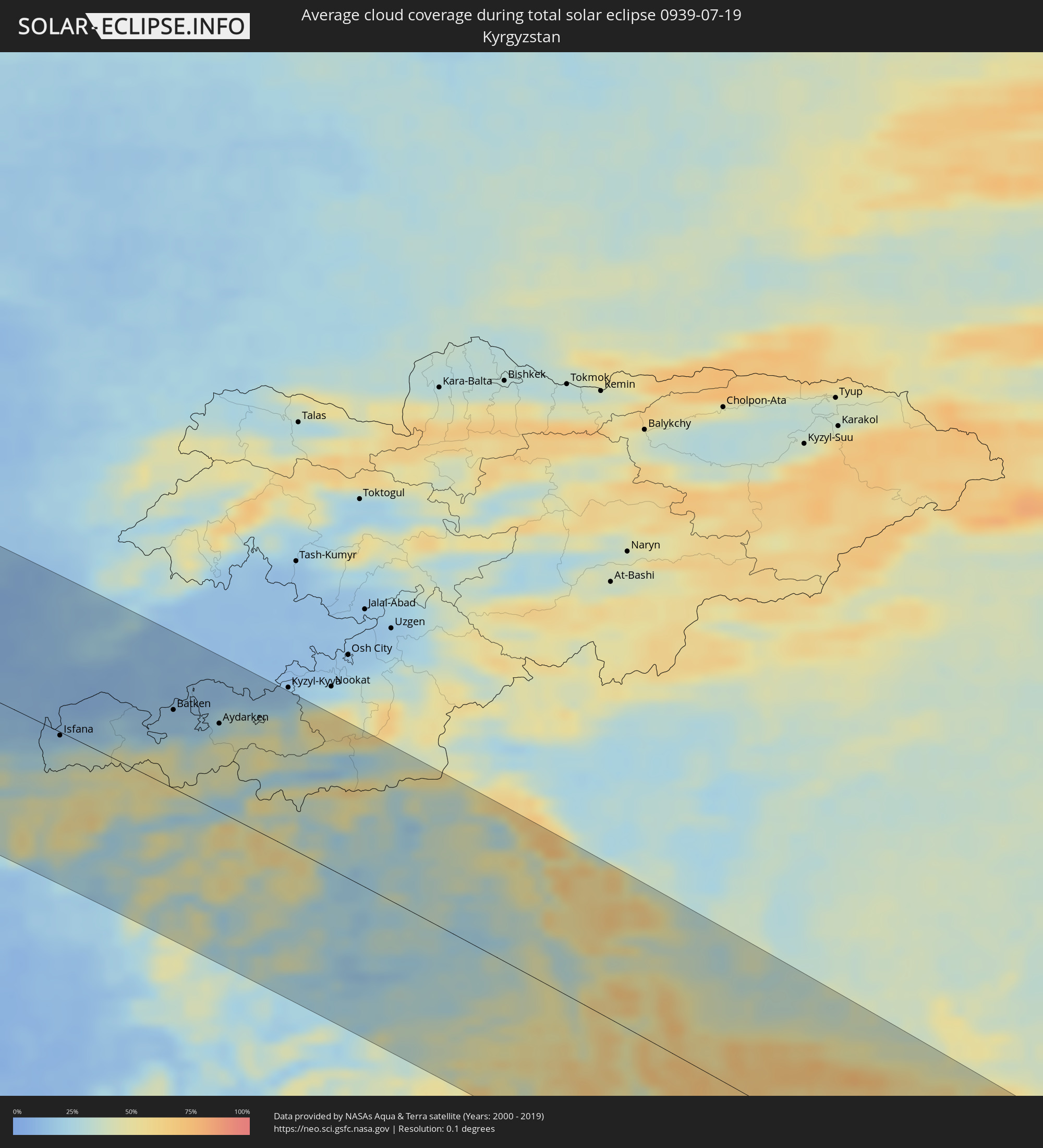 Kirgisistan
 Volksrepublik China
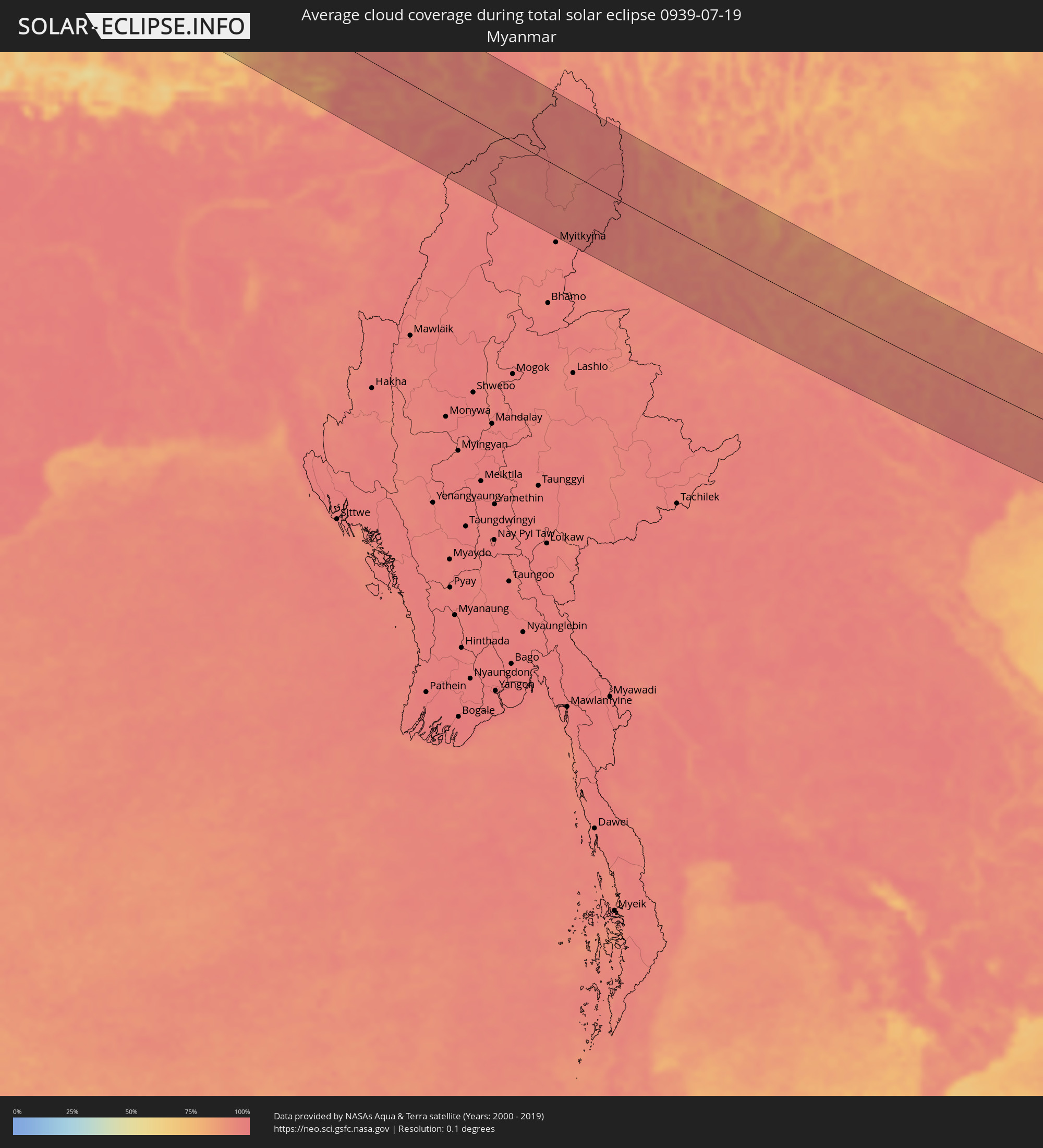 Myanmar
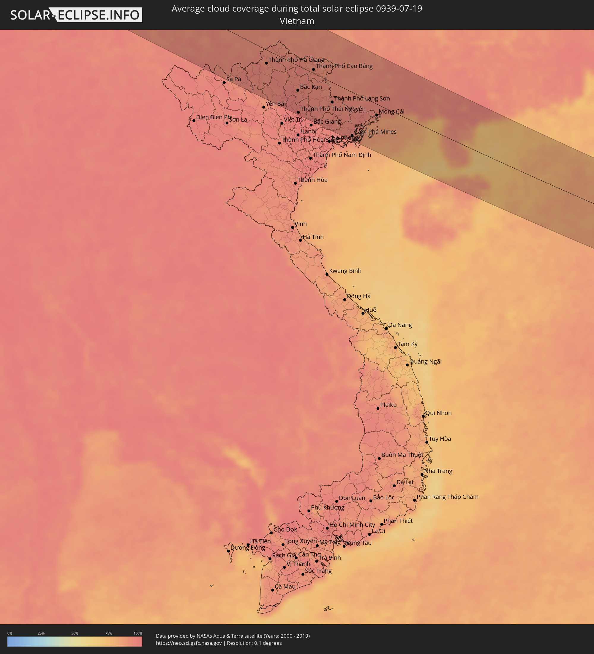 Vietnam
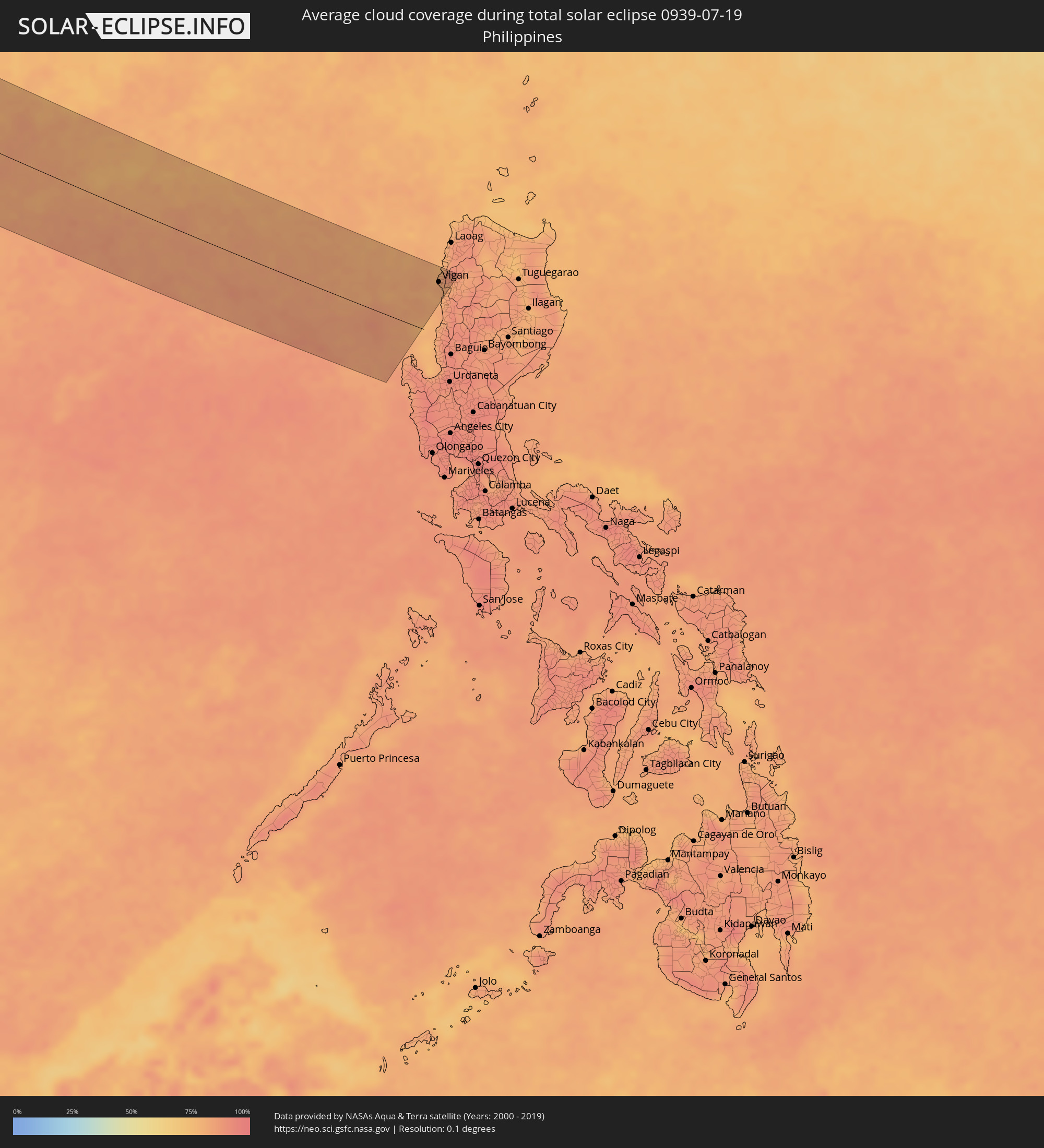 Philippinen
Orte im Finsternispfad
Die nachfolgene Tabelle zeigt Städte und Orte mit mehr als 5.000 Einwohnern, die sich im Finsternispfad befinden. Städte mit mehr als 100.000 Einwohnern sind dick gekennzeichnet. Mit einem Klick auf den Ort öffnet sich eine Detailkarte die die Lage des jeweiligen Ortes zusammen mit dem Verlauf der zentralen Finsternis präsentiert.
| Ort | Typ | Dauer der Verfinsterung | Ortszeit bei maximaler Verfinsterung | Entfernung zur Zentrallinie | Ø Bewölkung |
|
Cacém, Lisbon
|
total | - | 06:55:06 UTC-00:36 | 114 km | 25% |
|
Lisbon, Lisbon
|
total | - | 06:55:06 UTC-00:36 | 103 km | 20% |
|
Sesimbra, Setúbal
|
total | - | 06:54:47 UTC-00:36 | 75 km | 38% |
|
Póvoa de Santa Iria, Lisbon
|
total | - | 06:55:18 UTC-00:36 | 116 km | 25% |
|
Setúbal, Setúbal
|
total | - | 06:54:57 UTC-00:36 | 75 km | 30% |
|
Portimão, Faro
|
total | - | 06:53:27 UTC-00:36 | 79 km | 23% |
|
Faro, Faro
|
total | - | 06:53:31 UTC-00:36 | 112 km | 30% |
|
Évora, Évora
|
total | - | 06:55:21 UTC-00:36 | 46 km | 12% |
|
Beja, Beja
|
total | - | 06:54:43 UTC-00:36 | 12 km | 10% |
|
Huelva, Andalusia
|
total | - | 07:30:57 UTC+00:00 | 121 km | 13% |
|
Móstoles, Madrid
|
total | - | 07:36:01 UTC+00:00 | 91 km | 14% |
|
Madrid, Madrid
|
total | - | 07:36:13 UTC+00:00 | 95 km | 14% |
|
Alcalá de Henares, Madrid
|
total | - | 07:36:29 UTC+00:00 | 91 km | 16% |
|
Albacete, Castille-La Mancha
|
total | - | 07:35:30 UTC+00:00 | 111 km | 12% |
|
Valencia, Valencia
|
total | - | 07:36:58 UTC+00:00 | 108 km | 23% |
|
Castelló de la Plana, Valencia
|
total | - | 07:37:48 UTC+00:00 | 64 km | 33% |
|
Terrassa, Catalonia
|
total | - | 07:41:08 UTC+00:00 | 38 km | 31% |
|
Barcelona, Catalonia
|
total | - | 07:41:01 UTC+00:00 | 15 km | 31% |
|
Marseille, Provence-Alpes-Côte d'Azur
|
total | - | 07:55:12 UTC+00:09 | 125 km | 31% |
|
Aubagne, Provence-Alpes-Côte d'Azur
|
total | - | 07:55:21 UTC+00:09 | 119 km | 22% |
|
Toulon, Provence-Alpes-Côte d'Azur
|
total | - | 07:55:26 UTC+00:09 | 91 km | 34% |
|
Hyères, Provence-Alpes-Côte d'Azur
|
total | - | 07:55:37 UTC+00:09 | 86 km | 33% |
|
Fréjus, Provence-Alpes-Côte d'Azur
|
total | - | 07:56:30 UTC+00:09 | 103 km | 28% |
|
Grasse, Provence-Alpes-Côte d'Azur
|
total | - | 07:56:57 UTC+00:09 | 123 km | 34% |
|
Antibes, Provence-Alpes-Côte d'Azur
|
total | - | 07:57:00 UTC+00:09 | 107 km | 34% |
|
Nice, Provence-Alpes-Côte d'Azur
|
total | - | 07:57:18 UTC+00:09 | 118 km | 32% |
|
Monaco
|
total | - | 07:57:28 UTC+00:09 | 117 km | 31% |
|
La Condamine
|
total | - | 07:57:28 UTC+00:09 | 117 km | 31% |
|
Monte-Carlo
|
total | - | 07:57:29 UTC+00:09 | 118 km | 31% |
|
Ajaccio, Corsica
|
total | - | 07:56:31 UTC+00:09 | 107 km | 21% |
|
Livorno, Tuscany
|
total | - | 08:50:38 UTC+01:00 | 26 km | 19% |
|
Modena, Emilia-Romagna
|
total | - | 08:52:31 UTC+01:00 | 130 km | 25% |
|
Prato, Tuscany
|
total | - | 08:51:48 UTC+01:00 | 44 km | 26% |
|
Florence, Tuscany
|
total | - | 08:51:50 UTC+01:00 | 30 km | 25% |
|
Bologna, Emilia-Romagna
|
total | - | 08:52:45 UTC+01:00 | 104 km | 25% |
|
Forlì, Emilia-Romagna
|
total | - | 08:53:10 UTC+01:00 | 59 km | 27% |
|
Perugia, Umbria
|
total | - | 08:52:16 UTC+01:00 | 67 km | 23% |
|
Acquaviva, Acquaviva
|
total | - | 08:53:15 UTC+01:00 | 21 km | 32% |
|
Poggio di Chiesanuova, Chiesanuova
|
total | - | 08:53:12 UTC+01:00 | 17 km | 32% |
|
San Marino, San Marino
|
total | - | 08:53:16 UTC+01:00 | 20 km | 32% |
|
Borgo Maggiore, Borgo Maggiore
|
total | - | 08:53:16 UTC+01:00 | 20 km | 32% |
|
Fiorentino, Fiorentino
|
total | - | 08:53:15 UTC+01:00 | 17 km | 29% |
|
Domagnano, Domagnano
|
total | - | 08:53:18 UTC+01:00 | 21 km | 29% |
|
Serravalle, Serravalle
|
total | - | 08:53:21 UTC+01:00 | 22 km | 27% |
|
Monte Giardino, Montegiardino
|
total | - | 08:53:16 UTC+01:00 | 16 km | 29% |
|
Faetano, Faetano
|
total | - | 08:53:19 UTC+01:00 | 18 km | 29% |
|
Rimini, Emilia-Romagna
|
total | - | 08:53:32 UTC+01:00 | 30 km | 24% |
|
Ancona, The Marches
|
total | - | 08:54:02 UTC+01:00 | 40 km | 22% |
|
Pula, Istarska
|
total | - | 08:55:50 UTC+01:00 | 90 km | 29% |
|
Rijeka, Primorsko-Goranska
|
total | - | 08:56:59 UTC+01:00 | 130 km | 36% |
|
Zadar, Zadarska
|
total | - | 08:56:36 UTC+01:00 | 19 km | 22% |
|
Karlovac, Karlovačka
|
total | - | 08:58:25 UTC+01:00 | 123 km | 29% |
|
Bihać, Federation of Bosnia and Herzegovina
|
total | - | 08:58:05 UTC+01:00 | 44 km | 39% |
|
Šibenik, Šibensko-Kniniska
|
total | - | 08:56:57 UTC+01:00 | 74 km | 27% |
|
Sisak, Sisačko-Moslavačka
|
total | - | 08:59:22 UTC+01:00 | 105 km | 30% |
|
Split, Splitsko-Dalmatinska
|
total | - | 08:57:22 UTC+01:00 | 108 km | 22% |
|
Prijedor, Republic of Srspka
|
total | - | 08:59:15 UTC+01:00 | 46 km | 32% |
|
Banja Luka, Republic of Srspka
|
total | - | 08:59:37 UTC+01:00 | 16 km | 35% |
|
Bugojno, Federation of Bosnia and Herzegovina
|
total | - | 08:59:11 UTC+01:00 | 67 km | 40% |
|
Zenica, Federation of Bosnia and Herzegovina
|
total | - | 08:59:54 UTC+01:00 | 60 km | 39% |
|
Slavonski Brod, Slavonski Brod-Posavina
|
total | - | 09:01:01 UTC+01:00 | 43 km | 34% |
|
Siklós, Baranya
|
total | - | 09:02:05 UTC+01:00 | 113 km | 40% |
|
Sarajevo, Federation of Bosnia and Herzegovina
|
total | - | 09:00:08 UTC+01:00 | 106 km | 45% |
|
Tuzla, Federation of Bosnia and Herzegovina
|
total | - | 09:01:13 UTC+01:00 | 36 km | 37% |
|
Mohács, Baranya
|
total | - | 09:02:41 UTC+01:00 | 122 km | 38% |
|
Osijek, Osječko-Baranjska
|
total | - | 09:02:16 UTC+01:00 | 74 km | 38% |
|
Brčko, Brčko
|
total | - | 09:01:44 UTC+01:00 | 2 km | 34% |
|
Bijeljina, Republic of Srspka
|
total | - | 09:02:08 UTC+01:00 | 21 km | 36% |
|
Bácsalmás, Bács-Kiskun
|
total | - | 09:03:38 UTC+01:00 | 126 km | 43% |
|
Subotica, Vojvodina
|
total | - | 09:04:02 UTC+01:00 | 118 km | 41% |
|
Novi Sad, Vojvodina
|
total | - | 09:03:26 UTC+01:00 | 23 km | 39% |
|
Užice, Central Serbia
|
total | - | 09:02:06 UTC+01:00 | 129 km | 44% |
|
Mórahalom, Csongrád
|
total | - | 09:04:25 UTC+01:00 | 128 km | 43% |
|
Valjevo, Central Serbia
|
total | - | 09:02:34 UTC+01:00 | 85 km | 41% |
|
Szeged, Csongrád
|
total | - | 09:04:47 UTC+01:00 | 127 km | 41% |
|
Zrenjanin, Vojvodina
|
total | - | 09:04:16 UTC+01:00 | 29 km | 38% |
|
Belgrade, Central Serbia
|
total | - | 09:03:50 UTC+01:00 | 36 km | 40% |
|
Makó, Csongrád
|
total | - | 09:05:11 UTC+01:00 | 118 km | 45% |
|
Pančevo, Vojvodina
|
total | - | 09:04:07 UTC+01:00 | 31 km | 35% |
|
Mezőhegyes, Bekes
|
total | - | 09:05:43 UTC+01:00 | 125 km | 45% |
|
Kragujevac, Central Serbia
|
total | - | 09:03:42 UTC+01:00 | 129 km | 43% |
|
Smederevo, Central Serbia
|
total | - | 09:04:19 UTC+01:00 | 58 km | 34% |
|
Battonya, Bekes
|
total | - | 09:05:57 UTC+01:00 | 118 km | 47% |
|
Timişoara, Timiş
|
total | - | 09:50:08 UTC+01:44 | 57 km | 47% |
|
Arad, Arad
|
total | - | 09:50:39 UTC+01:44 | 103 km | 49% |
|
Sibiu, Sibiu
|
total | - | 09:54:12 UTC+01:44 | 25 km | 45% |
|
Piteşti, Argeş
|
total | - | 09:54:28 UTC+01:44 | 88 km | 38% |
|
Braşov, Braşov
|
total | - | 09:56:11 UTC+01:44 | 8 km | 66% |
|
Ploieşti, Prahova
|
total | - | 09:56:16 UTC+01:44 | 89 km | 48% |
|
Bacău, Bacău
|
total | - | 09:58:47 UTC+01:44 | 81 km | 40% |
|
Brăila, Brăila
|
total | - | 09:59:31 UTC+01:44 | 71 km | 39% |
|
Galaţi, Galaţi
|
total | - | 09:59:44 UTC+01:44 | 52 km | 37% |
|
Cahul, Cahul
|
total | - | 10:10:52 UTC+01:55 | 2 km | 42% |
|
Vulcăneşti, Găgăuzia
|
total | - | 10:11:03 UTC+01:55 | 28 km | 45% |
|
Hînceşti, Hînceşti
|
total | - | 10:12:04 UTC+01:55 | 97 km | 48% |
|
Straşeni, Strășeni
|
total | - | 10:12:18 UTC+01:55 | 132 km | 53% |
|
Comrat, Găgăuzia
|
total | - | 10:11:50 UTC+01:55 | 38 km | 48% |
|
Ceadîr-Lunga, Găgăuzia
|
total | - | 10:11:57 UTC+01:55 | 11 km | 47% |
|
Izmayil, Odessa
|
total | - | 10:18:35 UTC+02:02 | 68 km | 33% |
|
Chisinau, Chişinău
|
total | - | 10:12:35 UTC+01:55 | 115 km | 51% |
|
Căuşeni, Căuşeni
|
total | - | 10:13:12 UTC+01:55 | 71 km | 48% |
|
Tiraspolul, Stînga Nistrului
|
total | - | 10:13:39 UTC+01:55 | 92 km | 48% |
|
Odessa, Odessa
|
total | - | 10:22:14 UTC+02:02 | 46 km | 44% |
|
Mykolayiv, Mykolaiv
|
total | - | 10:24:29 UTC+02:02 | 95 km | 42% |
|
Kherson, Kherson
|
total | - | 10:25:19 UTC+02:02 | 58 km | 42% |
|
Yevpatoriya, Republic of Crimea
|
total | - | 10:39:51 UTC+02:16 | 105 km | 37% |
|
Melitopol’, Zaporizhia
|
total | - | 10:29:53 UTC+02:02 | 76 km | 48% |
|
Kerch, Republic of Crimea
|
total | - | 10:45:16 UTC+02:16 | 90 km | 44% |
|
Berdyans’k, Zaporizhia
|
total | - | 10:32:15 UTC+02:02 | 68 km | 42% |
|
Mariupol, Donetsk
|
total | - | 10:33:34 UTC+02:02 | 106 km | 46% |
|
Yeysk, Krasnodarskiy
|
total | - | 11:02:57 UTC+02:30 | 65 km | 42% |
|
Taganrog, Rostov Oblast
|
total | - | 11:04:05 UTC+02:30 | 126 km | 41% |
|
Krasnodar, Krasnodarskiy
|
total | - | 11:03:56 UTC+02:30 | 117 km | 48% |
|
Azov, Rostov Oblast
|
total | - | 11:04:57 UTC+02:30 | 114 km | 43% |
|
Rostov-na-Donu, Rostov Oblast
|
total | - | 11:05:29 UTC+02:30 | 129 km | 47% |
|
Armavir, Krasnodarskiy
|
total | - | 11:07:50 UTC+02:30 | 111 km | 50% |
|
Stavropol’, Stavropol'skiy
|
total | - | 11:09:23 UTC+02:30 | 99 km | 49% |
|
Elista, Kalmykiya
|
total | - | 11:13:22 UTC+02:30 | 61 km | 49% |
|
Astrakhan, Astrakhan
|
total | - | 12:10:05 UTC+03:20 | 111 km | 31% |
|
Aktau, Mangghystaū
|
total | - | 12:22:07 UTC+03:25 | 132 km | 26% |
|
Zhetibay, Mangghystaū
|
total | - | 12:23:52 UTC+03:25 | 120 km | 30% |
|
Shetpe, Mangghystaū
|
total | - | 12:23:34 UTC+03:25 | 58 km | 30% |
|
Zhanaozen, Mangghystaū
|
total | - | 12:25:30 UTC+03:25 | 132 km | 28% |
|
Beyneu, Mangghystaū
|
total | - | 12:28:16 UTC+03:25 | 130 km | 28% |
|
Köneürgench, Daşoguz
|
total | - | 13:05:58 UTC+03:53 | 88 km | 15% |
|
Akdepe
|
total | - | 13:06:38 UTC+03:53 | 111 km | 13% |
|
Nukus, Karakalpakstan
|
total | - | 13:41:00 UTC+04:27 | 63 km | 15% |
|
Yylanly, Daşoguz
|
total | - | 13:07:21 UTC+03:53 | 126 km | 13% |
|
Boldumsaz, Daşoguz
|
total | - | 13:07:05 UTC+03:53 | 95 km | 13% |
|
Daşoguz, Daşoguz
|
total | - | 13:07:54 UTC+03:53 | 117 km | 13% |
|
Urganch, Xorazm
|
total | - | 13:43:44 UTC+04:27 | 128 km | 11% |
|
Navoiy, Navoiy
|
total | - | 13:53:32 UTC+04:27 | 128 km | 8% |
|
Samarqand, Samarqand
|
total | - | 13:56:39 UTC+04:27 | 116 km | 10% |
|
Panjakent, Viloyati Sughd
|
total | - | 14:05:12 UTC+04:35 | 109 km | 12% |
|
Jizzax, Jizzax
|
total | - | 13:57:26 UTC+04:27 | 38 km | 12% |
|
Chardara, Ongtüstik Qazaqstan
|
total | - | 13:50:06 UTC+04:21 | 82 km | 12% |
|
Asyqata, Ongtüstik Qazaqstan
|
total | - | 13:51:11 UTC+04:21 | 60 km | 8% |
|
Atakent, Ongtüstik Qazaqstan
|
total | - | 13:51:27 UTC+04:21 | 60 km | 8% |
|
Slavyanka, Ongtüstik Qazaqstan
|
total | - | 13:51:46 UTC+04:21 | 43 km | 10% |
|
Istaravshan, Viloyati Sughd
|
total | - | 14:06:48 UTC+04:35 | 15 km | 17% |
|
Tashkent, Toshkent Shahri
|
total | - | 13:57:58 UTC+04:27 | 128 km | 11% |
|
Bekobod, Toshkent
|
total | - | 13:59:28 UTC+04:27 | 25 km | 12% |
|
Bŭston, Viloyati Sughd
|
total | - | 14:06:28 UTC+04:35 | 58 km | 12% |
|
Proletar, Viloyati Sughd
|
total | - | 14:07:12 UTC+04:35 | 29 km | 11% |
|
Isfana, Batken
|
total | - | 14:30:53 UTC+04:58 | 3 km | 24% |
|
Suluktu, Batken
|
total | - | 14:30:49 UTC+04:58 | 8 km | 18% |
|
Olmaliq, Toshkent
|
total | - | 13:59:06 UTC+04:27 | 100 km | 15% |
|
Khŭjand, Viloyati Sughd
|
total | - | 14:07:13 UTC+04:35 | 45 km | 11% |
|
Adrasmon, Viloyati Sughd
|
total | - | 14:07:15 UTC+04:35 | 95 km | 16% |
|
Shaydon, Viloyati Sughd
|
total | - | 14:07:45 UTC+04:35 | 111 km | 14% |
|
Konibodom, Viloyati Sughd
|
total | - | 14:08:23 UTC+04:35 | 76 km | 13% |
|
Isfara, Viloyati Sughd
|
total | - | 14:08:54 UTC+04:35 | 67 km | 14% |
|
Batken, Batken
|
total | - | 14:32:28 UTC+04:58 | 68 km | 15% |
|
Qo‘qon, Fergana
|
total | - | 14:01:28 UTC+04:27 | 119 km | 13% |
|
Aydarken, Batken
|
total | - | 14:33:23 UTC+04:58 | 77 km | 36% |
|
North Lakhimpur, Assam
|
total | - | 15:37:16 UTC+05:21 | 117 km | 95% |
|
Sibsāgar, Assam
|
total | - | 15:37:52 UTC+05:21 | 115 km | 96% |
|
Dibrugarh, Assam
|
total | - | 15:37:20 UTC+05:21 | 54 km | 95% |
|
Sonāri, Assam
|
total | - | 15:38:00 UTC+05:21 | 93 km | 94% |
|
Mon, Nagaland
|
total | - | 15:38:25 UTC+05:21 | 119 km | 94% |
|
Pāsighāt, Arunachal Pradesh
|
total | - | 15:36:45 UTC+05:21 | 23 km | 93% |
|
Tinsukia, Assam
|
total | - | 15:37:33 UTC+05:21 | 31 km | 97% |
|
Dum Duma, Assam
|
total | - | 15:37:32 UTC+05:21 | 14 km | 94% |
|
Margherita, Arunachal Pradesh
|
total | - | 15:37:58 UTC+05:21 | 36 km | 96% |
|
Kunming, Yunnan
|
total | - | 18:22:02 UTC+08:00 | 81 km | 86% |
|
Gejiu, Yunnan
|
total | - | 18:24:07 UTC+08:00 | 65 km | 92% |
|
Kaiyuan, Yunnan
|
total | - | 18:23:45 UTC+08:00 | 24 km | 90% |
|
Lào Cai, Lào Cai
|
total | - | 17:31:56 UTC+07:06 | 114 km | 91% |
|
Wenshan City, Yunnan
|
total | - | 18:24:18 UTC+08:00 | 14 km | 91% |
|
Thành Phố Hà Giang, Hà Giang
|
total | - | 17:31:41 UTC+07:06 | 34 km | 91% |
|
Thành Phố Tuyên Quang, Tuyên Quang
|
total | - | 17:32:50 UTC+07:06 | 123 km | 93% |
|
Bắc Kạn, Bắc Kạn
|
total | - | 17:32:32 UTC+07:06 | 62 km | 95% |
|
Thành Phố Thái Nguyên, Thái Nguyên
|
total | - | 17:33:09 UTC+07:06 | 117 km | 97% |
|
Thành Phố Cao Bằng, Cao Bằng
|
total | - | 17:32:00 UTC+07:06 | 9 km | 91% |
|
Thành Phố Lạng Sơn, Lạng Sơn
|
total | - | 17:32:56 UTC+07:06 | 50 km | 92% |
|
Cẩm Phả Mines, Quảng Ninh
|
total | - | 17:33:52 UTC+07:06 | 109 km | 91% |
|
Móng Cái, Quảng Ninh
|
total | - | 17:33:21 UTC+07:06 | 28 km | 88% |
|
Nanning, Guangxi Zhuang Autonomous Region
|
total | - | 18:25:17 UTC+08:00 | 117 km | 94% |
|
Beihai, Guangxi Zhuang Autonomous Region
|
total | - | 18:26:44 UTC+08:00 | 18 km | 87% |
|
Haikou, Hainan
|
total | - | 18:28:11 UTC+08:00 | 73 km | 87% |
|
Zhanjiang, Guangdong
|
total | - | 18:26:55 UTC+08:00 | 52 km | 93% |
|
Zhongshan, Guangdong
|
total | - | 18:26:52 UTC+08:00 | 66 km | 87% |
|
Vigan, Ilocos
|
total | - | 18:28:38 UTC+08:00 | 88 km | 81% |
|
Bantay, Ilocos
|
total | - | 18:28:38 UTC+08:00 | 89 km | 81% |
|
Cabugao, Ilocos
|
total | - | 18:28:26 UTC+08:00 | 113 km | 88% |