Totale Sonnenfinsternis vom 09.07.0948
| Wochentag: | Dienstag |
| Maximale Dauer der Verfinsterung: | 03m27s |
| Maximale Breite des Finsternispfades: | 431 km |
| Saroszyklus: | 90 |
| Bedeckungsgrad: | 100% |
| Magnitude: | 1.0621 |
| Gamma: | 0.8793 |
Wo kann man die Sonnenfinsternis vom 09.07.0948 sehen?
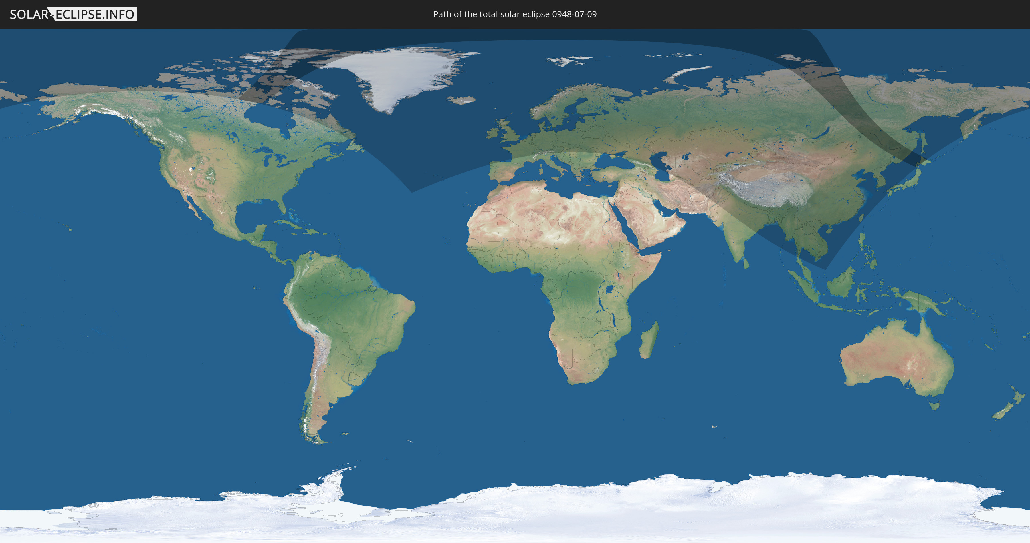
Die Sonnenfinsternis am 09.07.0948 kann man in 66 Ländern als partielle Sonnenfinsternis beobachten.
Der Finsternispfad verläuft durch 5 Länder. Nur in diesen Ländern ist sie als totale Sonnenfinsternis zu sehen.
In den folgenden Ländern ist die Sonnenfinsternis total zu sehen
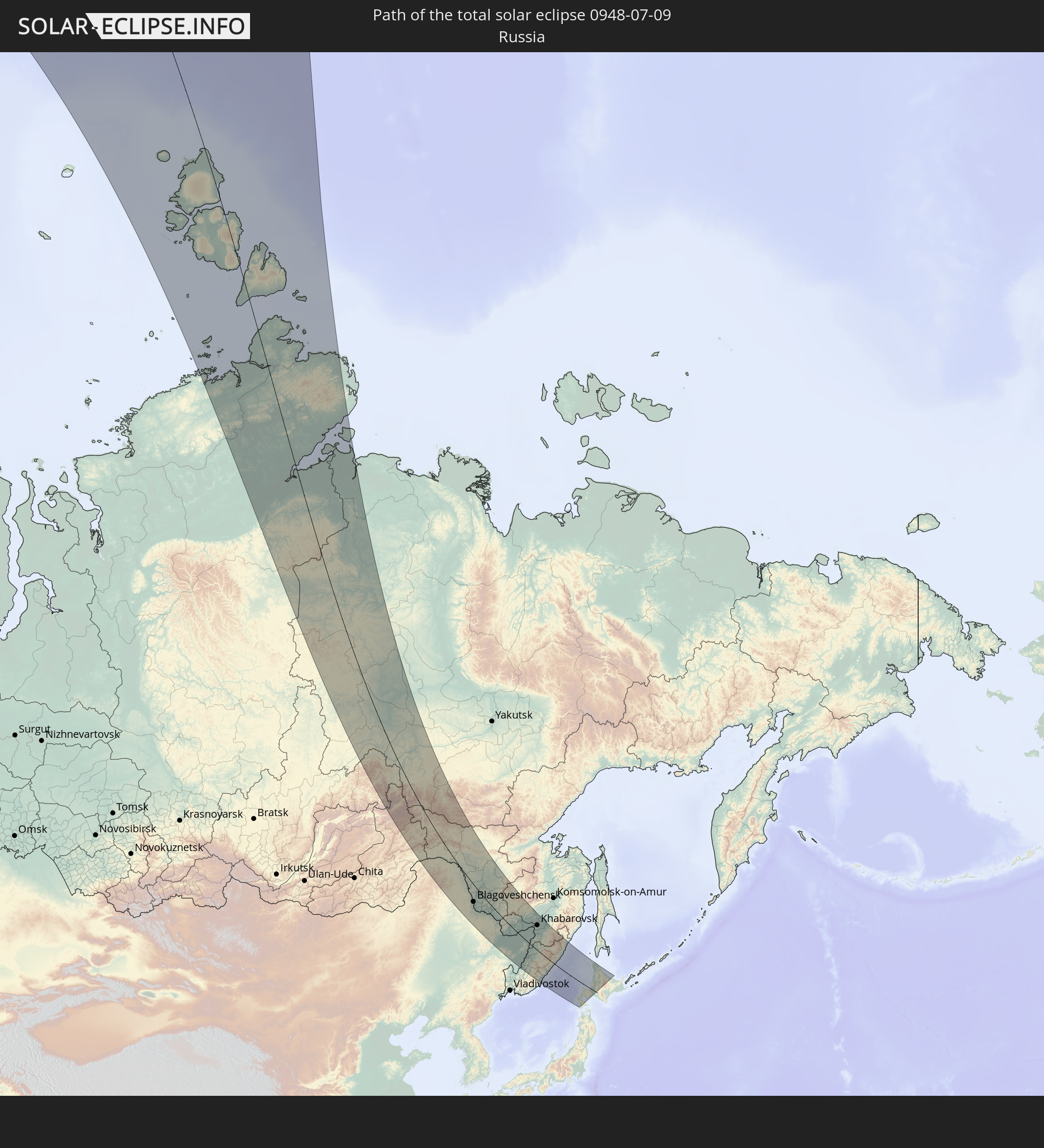 Russland
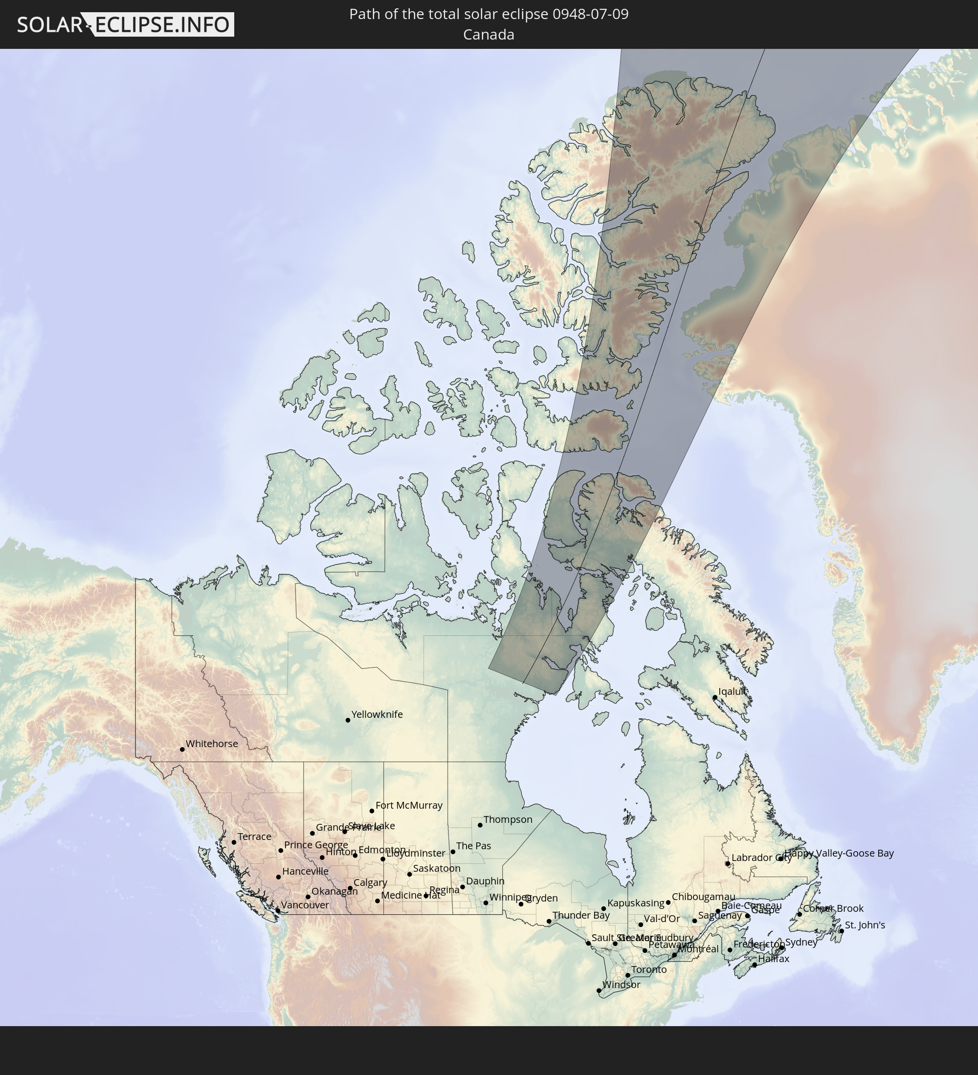 Kanada
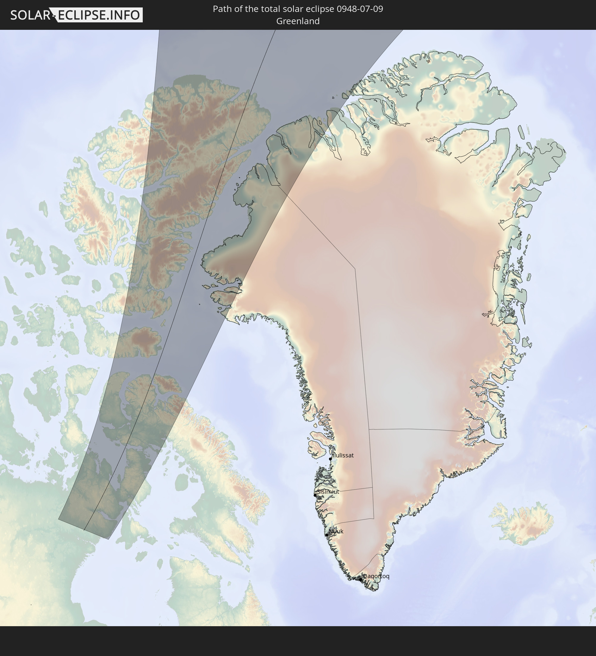 Grönland
 Volksrepublik China
 Japan
Japan
In den folgenden Ländern ist die Sonnenfinsternis partiell zu sehen
 Russland
 Vereinigte Staaten
 Kanada
 Grönland
 Portugal
 Island
 Spanien
 Irland
 Spitzbergen
 Vereinigtes Königreich
 Färöer
 Frankreich
 Isle of Man
 Guernsey
 Jersey
 Belgien
 Niederlande
 Norwegen
 Luxemburg
 Deutschland
 Schweiz
 Italien
 Dänemark
 Liechtenstein
 Österreich
 Schweden
 Tschechien
 Slowenien
 Polen
Polen
 Ungarn
 Slowakei
 Åland Islands
 Rumänien
 Finnland
 Litauen
 Lettland
 Estland
 Ukraine
 Weißrussland
 Moldawien
 Iran
Iran
 Aserbaidschan
 Kasachstan
 Turkmenistan
 Usbekistan
 Afghanistan
 Pakistan
 Tadschikistan
 Indien
 Kirgisistan
 Volksrepublik China
 Nepal
Nepal
 Mongolei
 Bangladesch
 Bhutan
 Myanmar
 Thailand
 Laos
Laos
 Vietnam
 Kambodscha
 Macau
Macau
 Hongkong
 Taiwan
 Japan
Japan
 Nordkorea
 Südkorea
Wie wird das Wetter während der totalen Sonnenfinsternis am 09.07.0948?
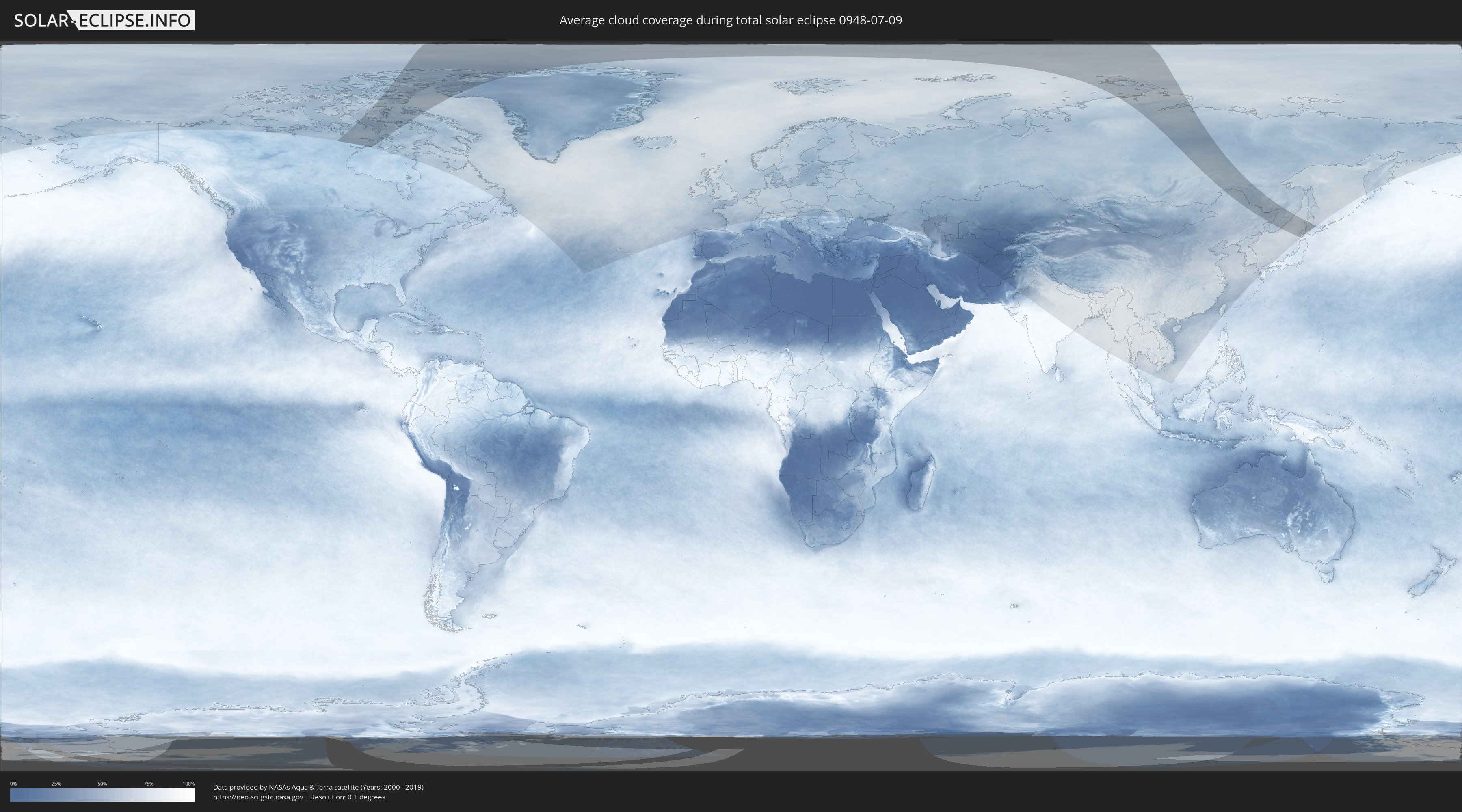
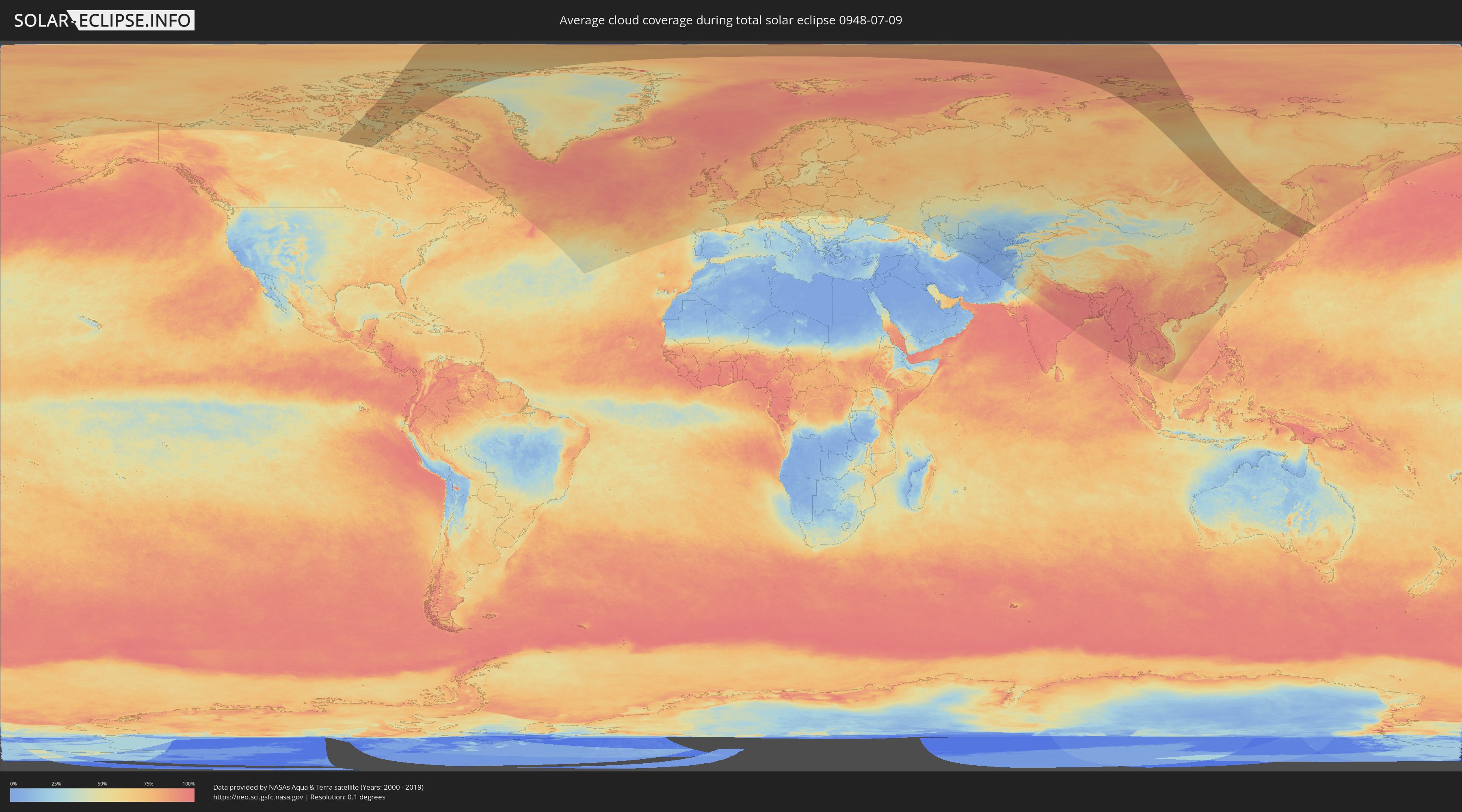
Wo ist der beste Ort, um die totale Sonnenfinsternis vom 09.07.0948 zu beobachten?
Die folgenden Karten zeigen die durchschnittliche Bewölkung für den Tag, an dem die totale Sonnenfinsternis
stattfindet. Mit Hilfe der Karten lässt sich der Ort entlang des Finsternispfades eingrenzen,
der die besten Aussichen auf einen klaren wolkenfreien Himmel bietet.
Trotzdem muss man immer lokale Gegenenheiten beachten und sollte sich genau über das Wetter an seinem
gewählten Beobachtungsort informieren.
Die Daten stammen von den beiden NASA-Satelliten
AQUA und TERRA
und wurden über einen Zeitraum von 19 Jahren (2000 - 2019) gemittelt.
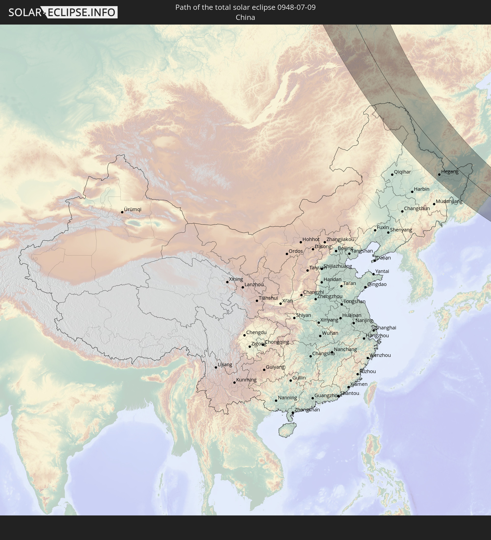
Detaillierte Länderkarten
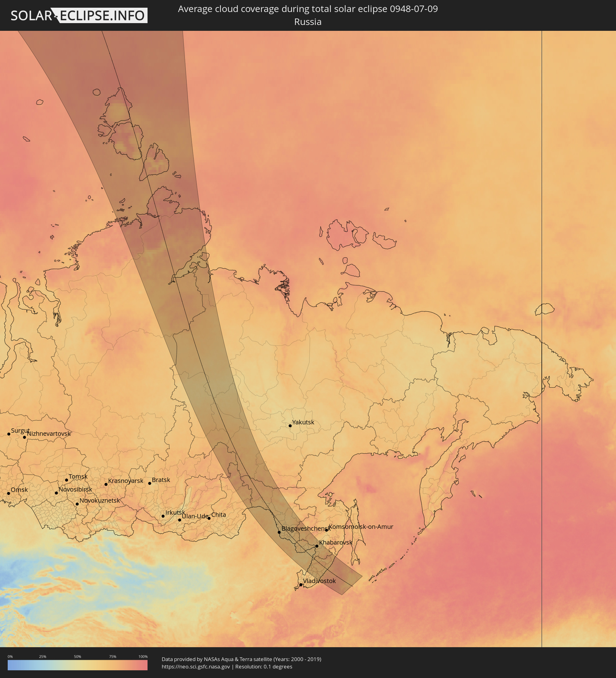 Russland
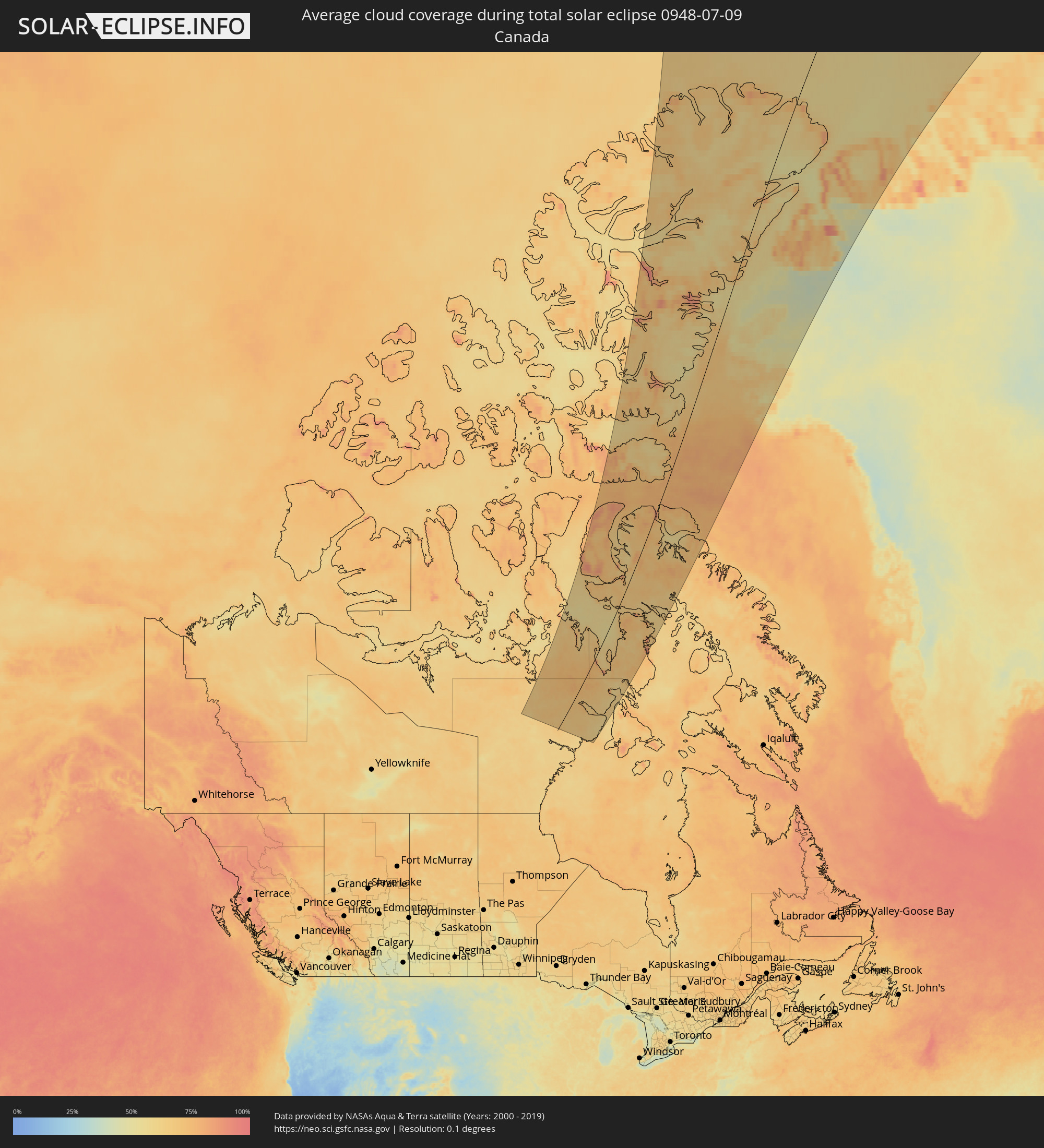 Kanada
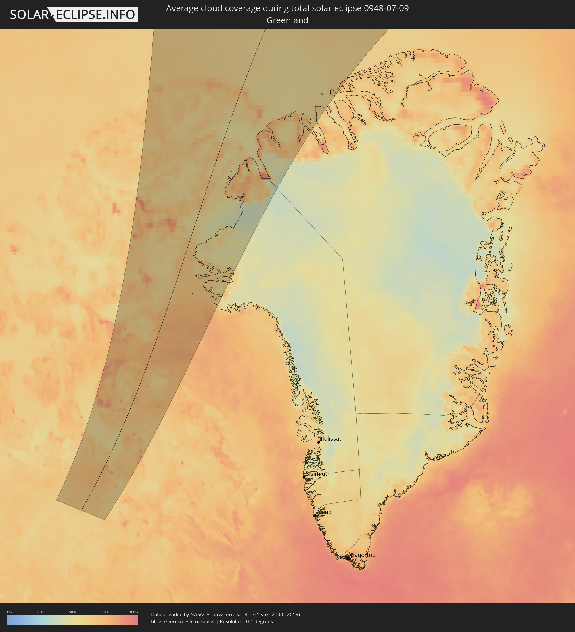 Grönland
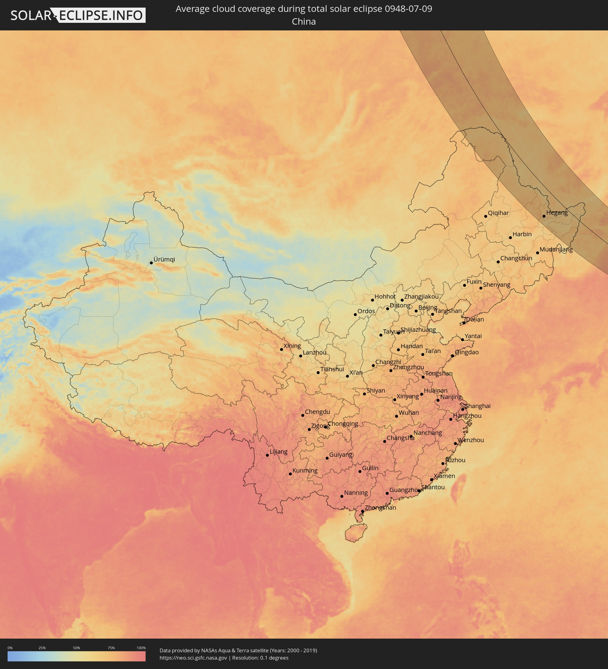 Volksrepublik China
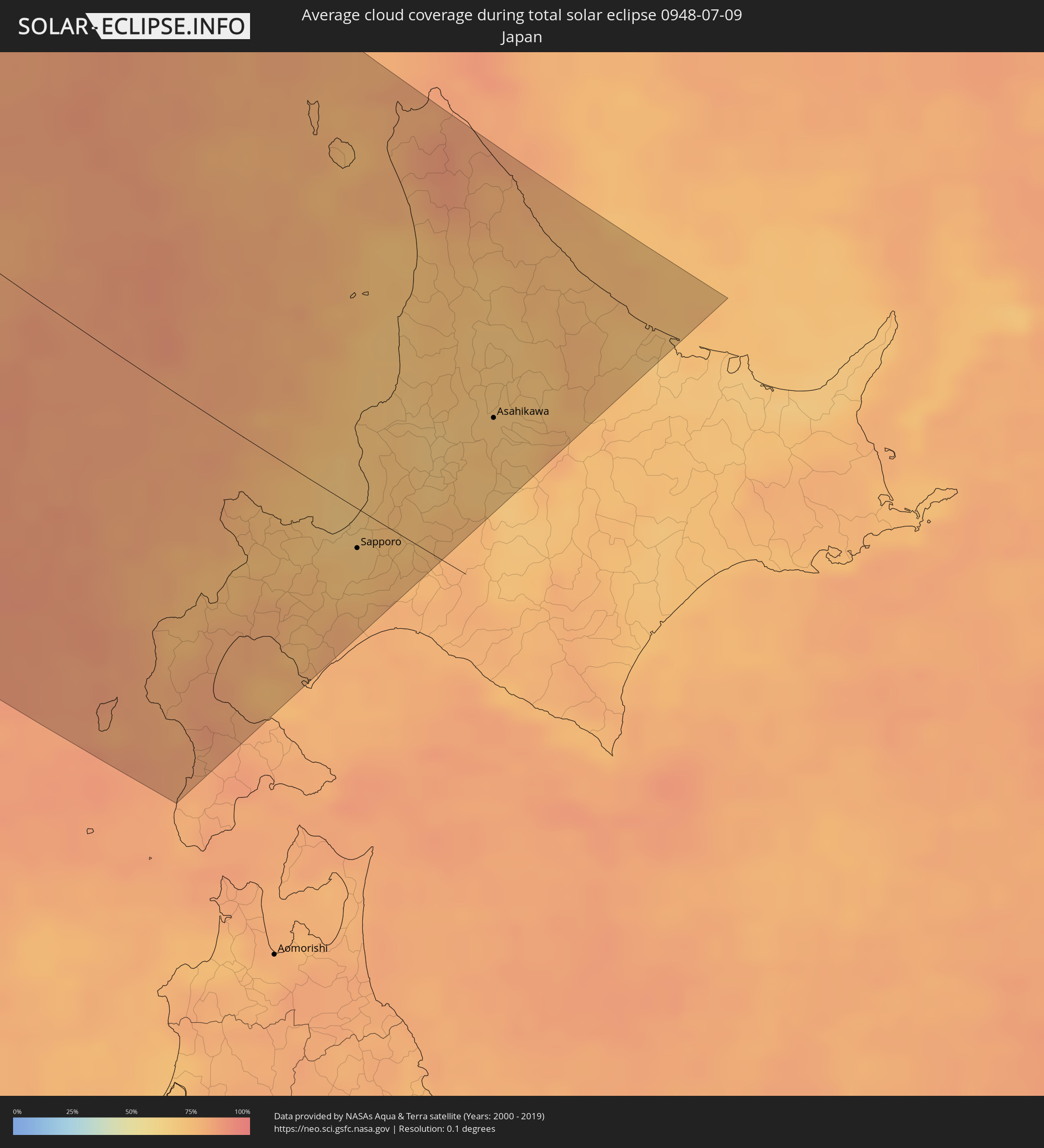 Japan
Japan
Orte im Finsternispfad
Die nachfolgene Tabelle zeigt Städte und Orte mit mehr als 5.000 Einwohnern, die sich im Finsternispfad befinden. Städte mit mehr als 100.000 Einwohnern sind dick gekennzeichnet. Mit einem Klick auf den Ort öffnet sich eine Detailkarte die die Lage des jeweiligen Ortes zusammen mit dem Verlauf der zentralen Finsternis präsentiert.
| Ort | Typ | Dauer der Verfinsterung | Ortszeit bei maximaler Verfinsterung | Entfernung zur Zentrallinie | Ø Bewölkung |
|
Aykhal, Sakha
|
total | - | 18:10:46 UTC+08:38 | 70 km | 63% |
|
Udachny, Sakha
|
total | - | 18:09:58 UTC+08:38 | 23 km | 64% |
|
Chernyshevskiy, Sakha
|
total | - | 18:16:13 UTC+08:38 | 151 km | 68% |
|
Mirny, Sakha
|
total | - | 18:17:13 UTC+08:38 | 105 km | 71% |
|
Lensk, Sakha
|
total | - | 18:20:32 UTC+08:38 | 142 km | 73% |
|
Suntar, Sakha
|
total | - | 18:18:04 UTC+08:38 | 60 km | 69% |
|
Nyurba, Sakha
|
total | - | 18:16:02 UTC+08:38 | 139 km | 65% |
|
Olyokminsk, Sakha
|
total | - | 18:21:11 UTC+08:38 | 119 km | 71% |
|
Yerofey Pavlovich, Amur
|
total | - | 18:32:03 UTC+08:38 | 146 km | 73% |
|
Skovorodino, Amur
|
total | - | 18:31:44 UTC+08:38 | 38 km | 71% |
|
Neryungri, Sakha
|
total | - | 18:27:11 UTC+08:38 | 158 km | 75% |
|
Tynda, Amur
|
total | - | 18:29:41 UTC+08:38 | 81 km | 74% |
|
Tahe, Heilongjiang
|
total | - | 17:55:20 UTC+08:00 | 100 km | 72% |
|
Chul’man, Sakha
|
total | - | 18:26:51 UTC+08:38 | 183 km | 75% |
|
Magdagachi, Amur
|
total | - | 18:32:18 UTC+08:38 | 32 km | 67% |
|
Zeya, Amur
|
total | - | 18:31:33 UTC+08:38 | 128 km | 68% |
|
Heihe, Heilongjiang
|
total | - | 17:58:03 UTC+08:00 | 97 km | 64% |
|
Blagoveshchensk, Amur
|
total | - | 18:36:57 UTC+08:38 | 91 km | 66% |
|
Shimanovsk, Amur
|
total | - | 18:34:13 UTC+08:38 | 46 km | 67% |
|
Konstantinovka, Amur
|
total | - | 18:37:51 UTC+08:38 | 118 km | 64% |
|
Srednebelaya, Amur
|
total | - | 18:36:14 UTC+08:38 | 39 km | 63% |
|
Tambovka, Amur
|
total | - | 18:37:05 UTC+08:38 | 78 km | 65% |
|
Svobodnyy, Amur
|
total | - | 18:35:06 UTC+08:38 | 19 km | 65% |
|
Seryshevo, Amur
|
total | - | 18:35:28 UTC+08:38 | 12 km | 67% |
|
Belogorsk, Amur
|
total | - | 18:35:43 UTC+08:38 | 5 km | 66% |
|
Poyarkovo, Amur
|
total | - | 18:37:39 UTC+08:38 | 80 km | 63% |
|
Youhao, Heilongjiang
|
total | - | 18:01:19 UTC+08:00 | 208 km | 69% |
|
Yichun, Heilongjiang
|
total | - | 18:01:30 UTC+08:00 | 215 km | 72% |
|
Yekaterinoslavka, Amur
|
total | - | 18:36:24 UTC+08:38 | 12 km | 68% |
|
Raychikhinsk, Amur
|
total | - | 18:37:12 UTC+08:38 | 28 km | 66% |
|
Zavitinsk, Amur
|
total | - | 18:36:42 UTC+08:38 | 2 km | 67% |
|
Xinqing, Heilongjiang
|
total | - | 18:00:28 UTC+08:00 | 137 km | 70% |
|
Bureya, Amur
|
total | - | 18:37:03 UTC+08:38 | 16 km | 61% |
|
Novobureyskiy, Amur
|
total | - | 18:37:04 UTC+08:38 | 11 km | 62% |
|
Arkhara, Amur
|
total | - | 18:37:33 UTC+08:38 | 19 km | 64% |
|
Talakan, Amur
|
total | - | 18:36:14 UTC+08:38 | 53 km | 66% |
|
Hegang, Heilongjiang
|
total | - | 18:01:36 UTC+08:00 | 170 km | 71% |
|
Jiamusi, Heilongjiang
|
total | - | 18:02:24 UTC+08:00 | 214 km | 67% |
|
Fengxiang, Heilongjiang
|
total | - | 18:01:06 UTC+08:00 | 125 km | 67% |
|
Amurzet, Jewish Autonomous Oblast
|
total | - | 18:48:21 UTC+08:47 | 101 km | 67% |
|
Fuli, Heilongjiang
|
total | - | 18:02:14 UTC+08:00 | 178 km | 69% |
|
Lingdong, Heilongjiang
|
total | - | 18:02:27 UTC+08:00 | 191 km | 70% |
|
Shuangyashan, Heilongjiang
|
total | - | 18:02:21 UTC+08:00 | 185 km | 70% |
|
Baoshan, Heilongjiang
|
total | - | 18:02:22 UTC+08:00 | 177 km | 67% |
|
Fujin, Heilongjiang
|
total | - | 18:01:09 UTC+08:00 | 88 km | 64% |
|
Baoqing, Heilongjiang
|
total | - | 18:02:25 UTC+08:00 | 156 km | 67% |
|
Novyy Urgal, Khabarovsk Krai
|
total | - | 18:42:53 UTC+08:47 | 237 km | 69% |
|
Leninskoye, Jewish Autonomous Oblast
|
total | - | 18:47:29 UTC+08:47 | 3 km | 63% |
|
Birobidzhan, Jewish Autonomous Oblast
|
total | - | 18:46:08 UTC+08:47 | 81 km | 67% |
|
Lesozavodsk, Primorskiy
|
total | - | 18:50:40 UTC+08:47 | 168 km | 69% |
|
Kirovskiy, Primorskiy
|
total | - | 18:51:11 UTC+08:47 | 197 km | 65% |
|
Gornyye Klyuchi, Primorskiy
|
total | - | 18:50:58 UTC+08:47 | 184 km | 68% |
|
Dal’nerechensk, Primorskiy
|
total | - | 18:49:55 UTC+08:47 | 113 km | 69% |
|
Smidovich, Jewish Autonomous Oblast
|
total | - | 18:46:07 UTC+08:47 | 111 km | 70% |
|
Luchegorsk, Primorskiy
|
total | - | 18:48:59 UTC+08:47 | 44 km | 72% |
|
Bikin, Khabarovsk Krai
|
total | - | 18:48:29 UTC+08:47 | 13 km | 68% |
|
Fuyuan, Heilongjiang
|
total | - | 17:58:46 UTC+08:00 | 116 km | 64% |
|
Vyazemskiy, Khabarovsk Krai
|
total | - | 18:47:17 UTC+08:47 | 73 km | 70% |
|
Khor, Khabarovsk Krai
|
total | - | 18:46:43 UTC+08:47 | 111 km | 68% |
|
Kavalerovo, Primorskiy
|
total | - | 18:51:39 UTC+08:47 | 194 km | 67% |
|
Korfovskiy, Khabarovsk Krai
|
total | - | 18:46:12 UTC+08:47 | 144 km | 71% |
|
Khabarovsk, Khabarovsk Krai
|
total | - | 18:45:49 UTC+08:47 | 167 km | 67% |
|
Khabarovsk Vtoroy, Khabarovsk Krai
|
total | - | 18:45:52 UTC+08:47 | 166 km | 68% |
|
Nekrasovka, Khabarovsk Krai
|
total | - | 18:45:57 UTC+08:47 | 163 km | 70% |
|
Knyaze-Volkonskoye, Khabarovsk Krai
|
total | - | 18:45:42 UTC+08:47 | 184 km | 66% |
|
Dal'negorsk, Primorskiy
|
total | - | 18:51:03 UTC+08:47 | 144 km | 68% |
|
Plastun, Primorskiy
|
total | - | 18:50:28 UTC+08:47 | 92 km | 73% |
|
Iwanai, Hokkaido
|
total | - | 19:03:16 UTC+09:00 | 65 km | 76% |
|
Yoichi, Hokkaido
|
total | - | 19:02:50 UTC+09:00 | 32 km | 73% |
|
Date, Hokkaido
|
total | - | 19:03:42 UTC+09:00 | 98 km | 78% |
|
Otaru, Hokkaido
|
total | - | 19:02:44 UTC+09:00 | 28 km | 71% |
|
Sapporo, Hokkaido
|
total | - | 19:02:42 UTC+09:00 | 20 km | 71% |
|
Ishikari, Hokkaido
|
total | - | 19:02:29 UTC+09:00 | 12 km | 70% |
|
Tōbetsu, Hokkaido
|
total | - | 19:02:26 UTC+09:00 | 1 km | 73% |
|
Ebetsu, Hokkaido
|
total | - | 19:02:33 UTC+09:00 | 12 km | 74% |
|
Kitahiroshima, Hokkaido
|
total | - | 19:02:42 UTC+09:00 | 27 km | 76% |
|
Rumoi, Hokkaido
|
total | - | 19:01:28 UTC+09:00 | 76 km | 71% |
|
Chitose, Hokkaido
|
total | - | 19:02:51 UTC+09:00 | 34 km | 79% |
|
Wakkanai, Hokkaido
|
total | - | 18:59:35 UTC+09:00 | 213 km | 81% |
|
Iwamizawa, Hokkaido
|
total | - | 19:02:20 UTC+09:00 | 21 km | 74% |
|
Makubetsu, Hokkaido
|
total | - | 18:59:34 UTC+09:00 | 217 km | 82% |
|
Bibai, Hokkaido
|
total | - | 19:02:07 UTC+09:00 | 32 km | 75% |
|
Sunagawa, Hokkaido
|
total | - | 19:01:54 UTC+09:00 | 45 km | 69% |
|
Takikawa, Hokkaido
|
total | - | 19:01:49 UTC+09:00 | 50 km | 68% |
|
Fukagawa, Hokkaido
|
total | - | 19:01:33 UTC+09:00 | 70 km | 69% |
|
Utashinai, Hokkaido
|
total | - | 19:01:47 UTC+09:00 | 56 km | 72% |
|
Akabira, Hokkaido
|
total | - | 19:01:44 UTC+09:00 | 58 km | 72% |
|
Ashibetsu, Hokkaido
|
total | - | 19:01:43 UTC+09:00 | 59 km | 71% |
|
Asahikawa, Hokkaido
|
total | - | 19:01:18 UTC+09:00 | 91 km | 70% |
|
Shimo-furano, Hokkaido
|
total | - | 19:01:49 UTC+09:00 | 50 km | 69% |
|
Nayoro, Hokkaido
|
total | - | 19:00:32 UTC+09:00 | 148 km | 73% |
|
Kamikawa, Hokkaido
|
total | - | 19:01:00 UTC+09:00 | 113 km | 77% |
|
Mombetsu, Hokkaido
|
total | - | 19:00:04 UTC+09:00 | 186 km | 74% |