Totale Sonnenfinsternis vom 08.11.1295
| Wochentag: | Dienstag |
| Maximale Dauer der Verfinsterung: | 03m17s |
| Maximale Breite des Finsternispfades: | 271 km |
| Saroszyklus: | 102 |
| Bedeckungsgrad: | 100% |
| Magnitude: | 1.0414 |
| Gamma: | 0.863 |
Wo kann man die Sonnenfinsternis vom 08.11.1295 sehen?
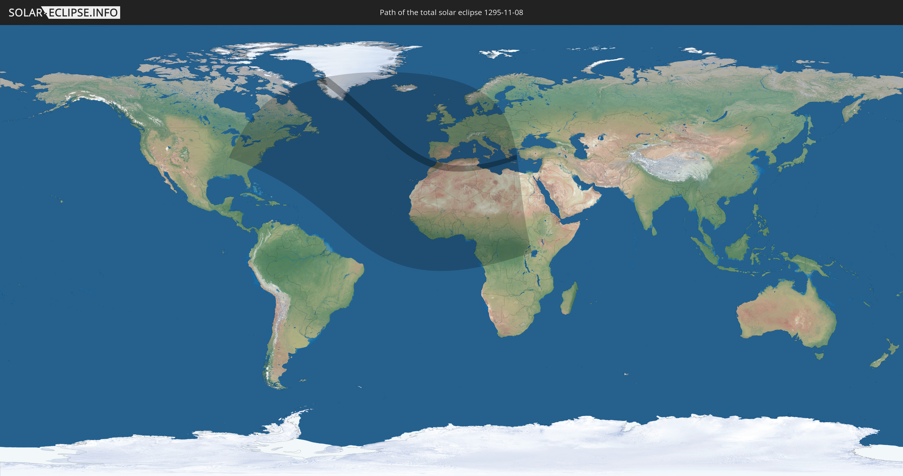
Die Sonnenfinsternis am 08.11.1295 kann man in 82 Ländern als partielle Sonnenfinsternis beobachten.
Der Finsternispfad verläuft durch 6 Länder. Nur in diesen Ländern ist sie als totale Sonnenfinsternis zu sehen.
In den folgenden Ländern ist die Sonnenfinsternis total zu sehen
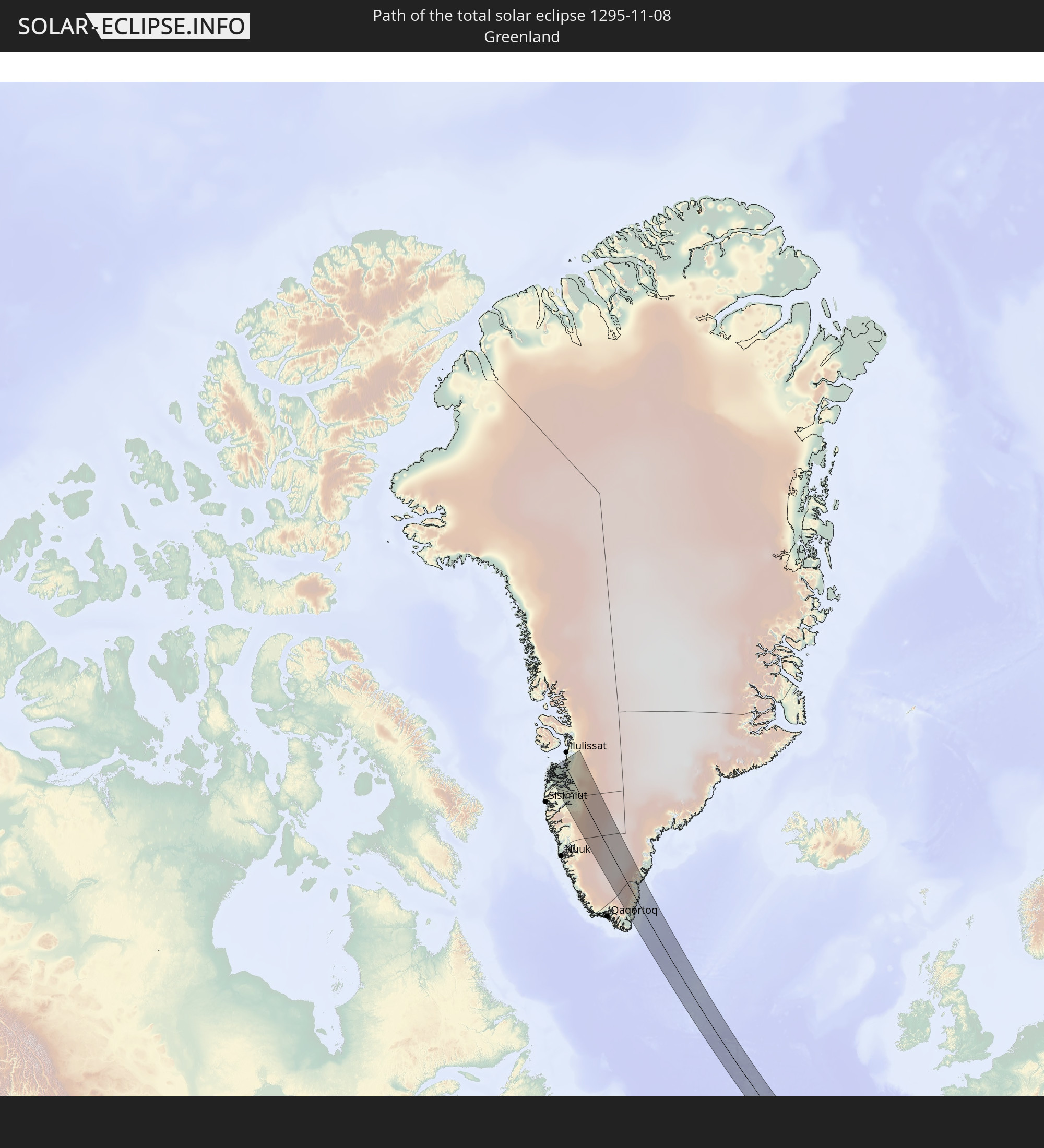 Grönland
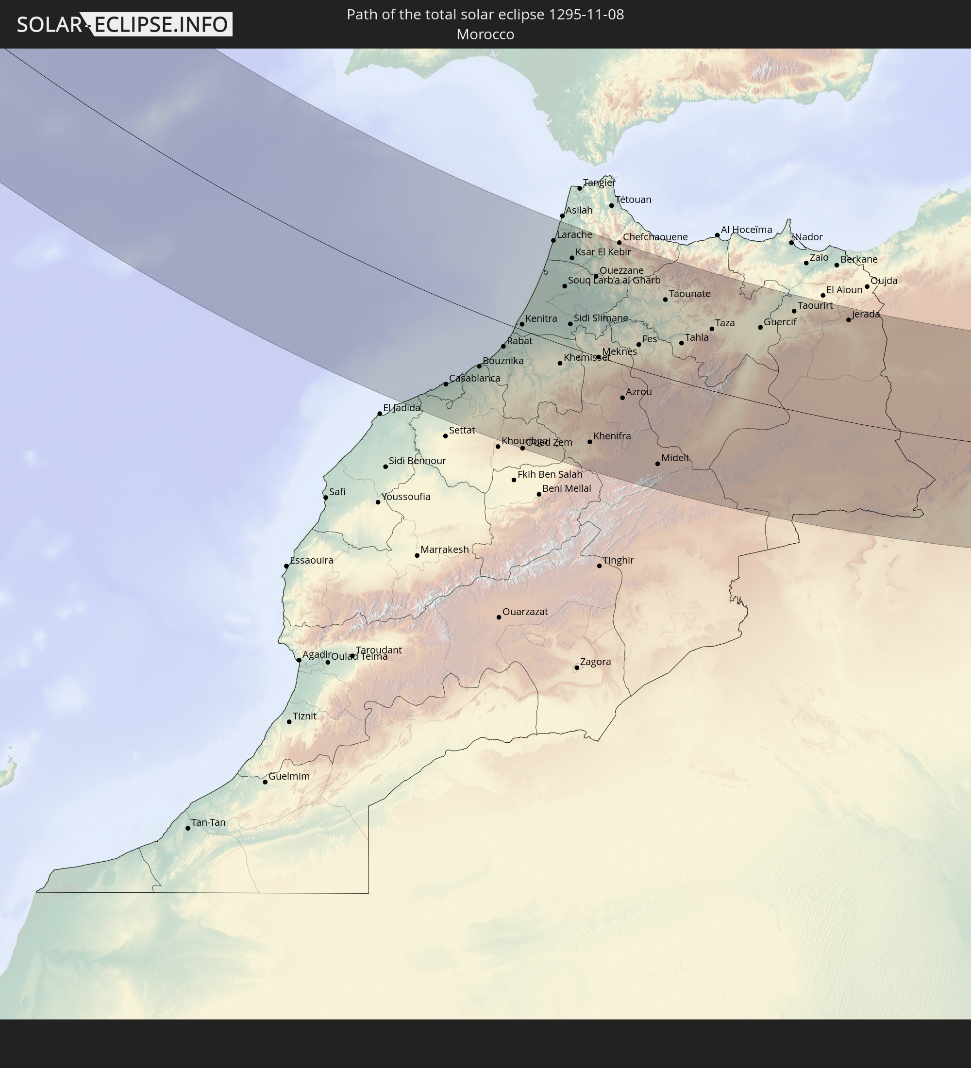 Marokko
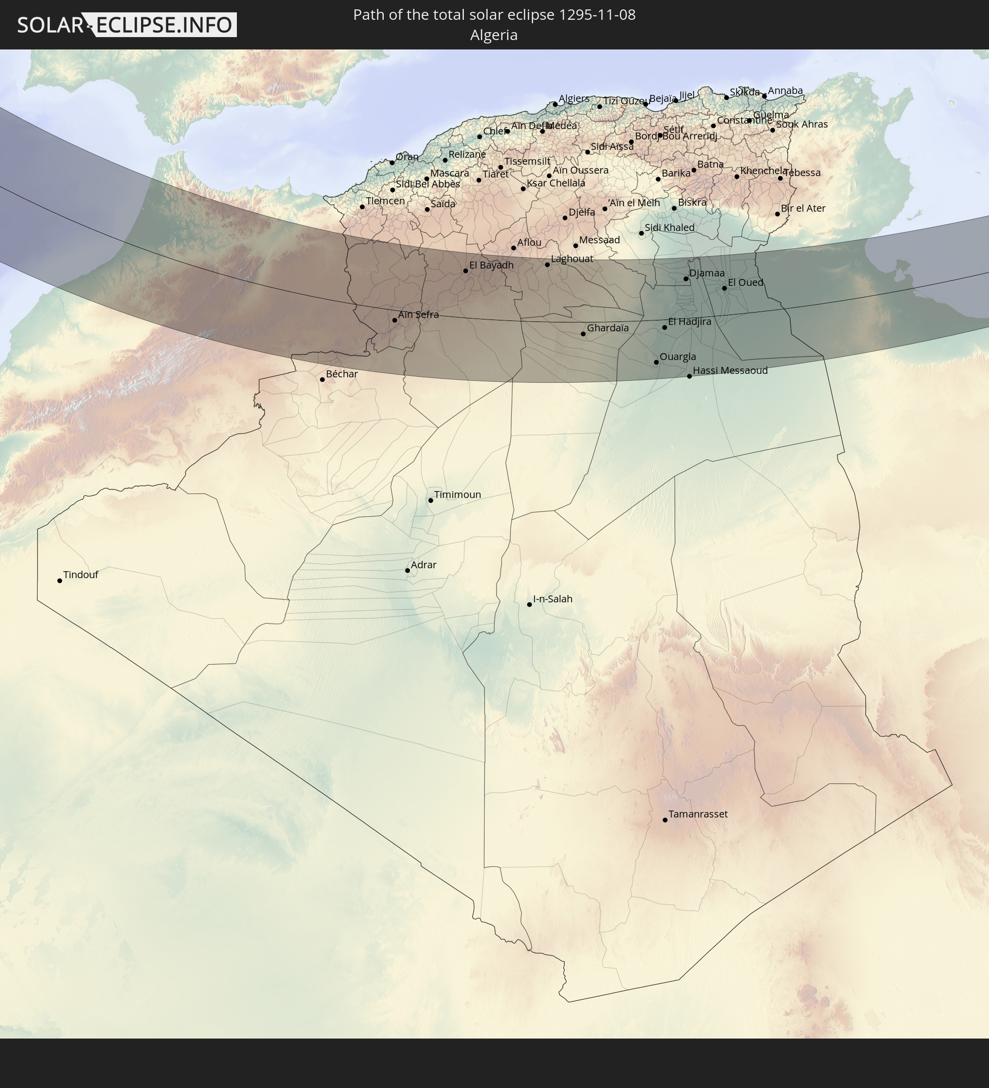 Algerien
 Tunesien
 Libyen
 Griechenland
In den folgenden Ländern ist die Sonnenfinsternis partiell zu sehen
 Russland
 Vereinigte Staaten
 Kanada
 Grönland
 Bermuda
 Saint-Pierre und Miquelon
 Portugal
 Kap Verde
 Island
 Spanien
 Senegal
 Mauretanien
 Gambia
 Guinea-Bissau
 Guinea
 Sierra Leone
 Marokko
 Mali
Mali
 Liberia
 Irland
 Algerien
 Vereinigtes Königreich
 Elfenbeinküste
 Färöer
 Burkina Faso
 Gibraltar
 Frankreich
 Isle of Man
 Ghana
Ghana
 Guernsey
 Jersey
 Togo
Togo
 Niger
Niger
 Benin
Benin
 Andorra
 Belgien
 Nigeria
 Niederlande
 Norwegen
 Äquatorialguinea
 Luxemburg
 Deutschland
 Schweiz
 São Tomé und Príncipe
 Italien
 Monaco
 Tunesien
 Dänemark
 Kamerun
 Gabun
Gabun
 Libyen
 Liechtenstein
 Österreich
 Schweden
 Republik Kongo
 Angola
 Tschechien
 Demokratische Republik Kongo
 San Marino
 Vatikanstadt
 Slowenien
 Tschad
 Kroatien
 Polen
Polen
 Malta
Malta
 Zentralafrikanische Republik
 Bosnien und Herzegowina
 Ungarn
 Slowakei
 Montenegro
 Serbien
 Albanien
 Griechenland
 Rumänien
 Mazedonien
 Sudan
Sudan
 Ukraine
 Bulgarien
 Ägypten
 Ruanda
 Tansania
 Uganda
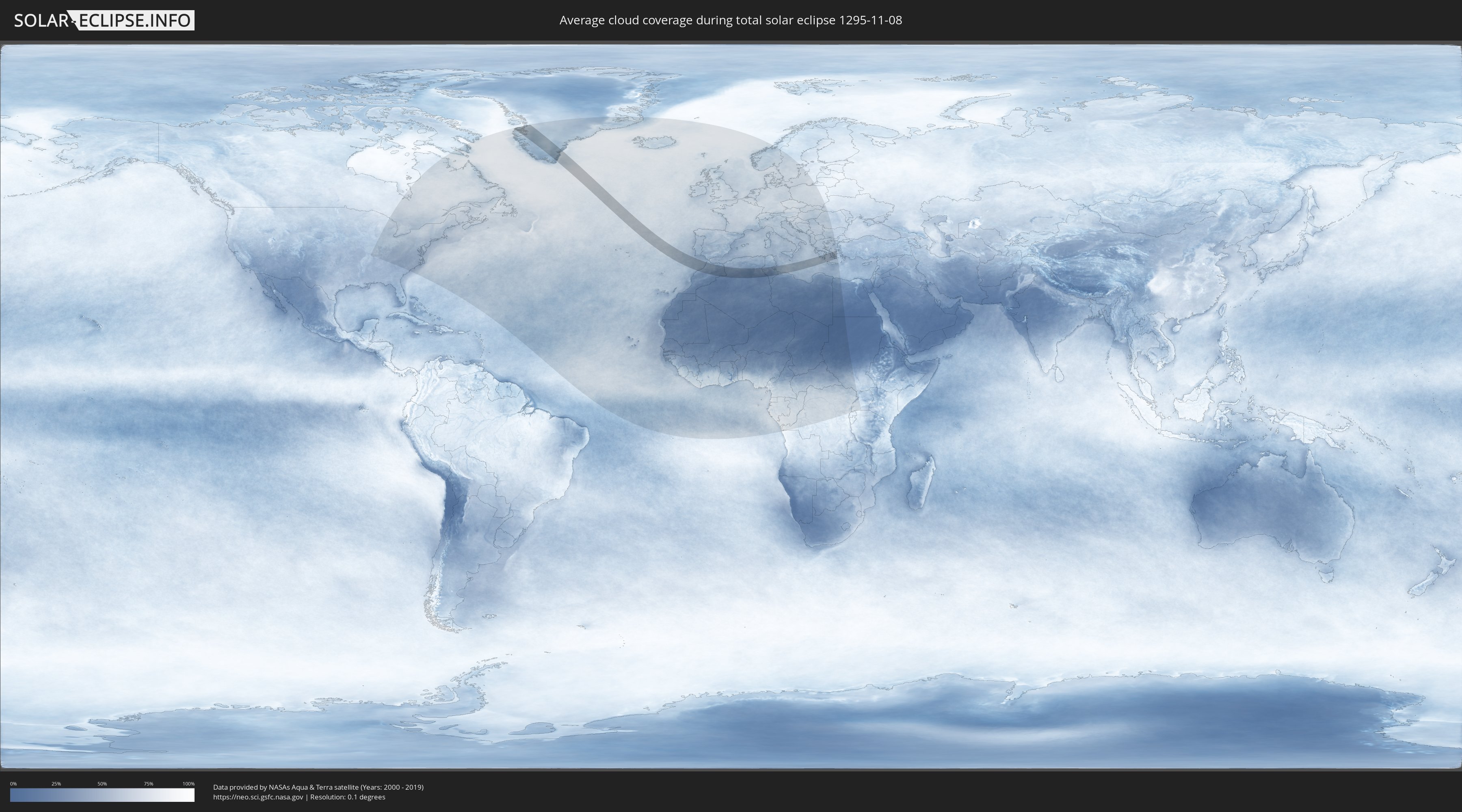
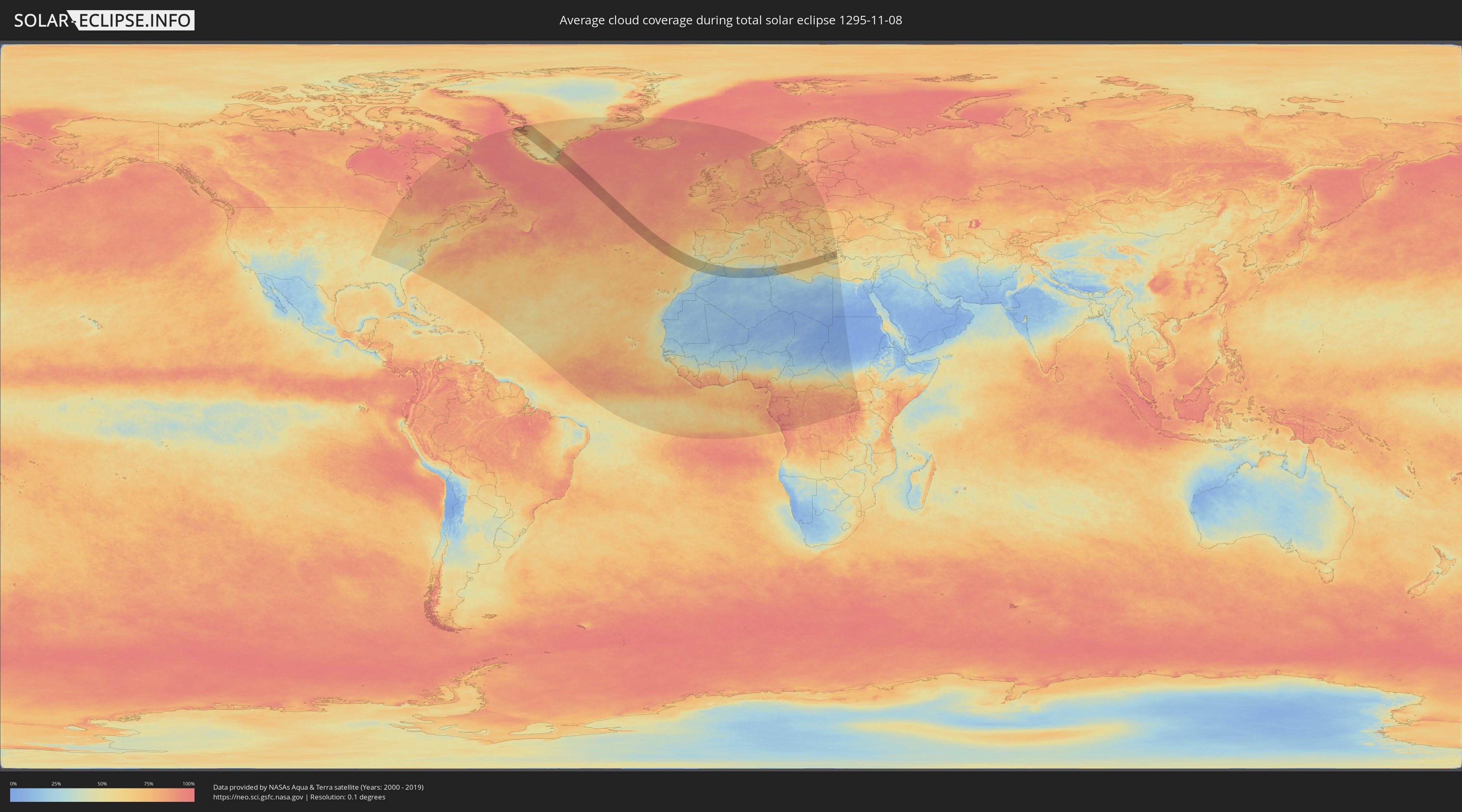
Wie wird das Wetter während der totalen Sonnenfinsternis am 08.11.1295?
Wo ist der beste Ort, um die totale Sonnenfinsternis vom 08.11.1295 zu beobachten?
Die folgenden Karten zeigen die durchschnittliche Bewölkung für den Tag, an dem die totale Sonnenfinsternis
stattfindet. Mit Hilfe der Karten lässt sich der Ort entlang des Finsternispfades eingrenzen,
der die besten Aussichen auf einen klaren wolkenfreien Himmel bietet.
Trotzdem muss man immer lokale Gegenenheiten beachten und sollte sich genau über das Wetter an seinem
gewählten Beobachtungsort informieren.
Die Daten stammen von den beiden NASA-Satelliten
AQUA und TERRA
und wurden über einen Zeitraum von 19 Jahren (2000 - 2019) gemittelt.
Detaillierte Länderkarten
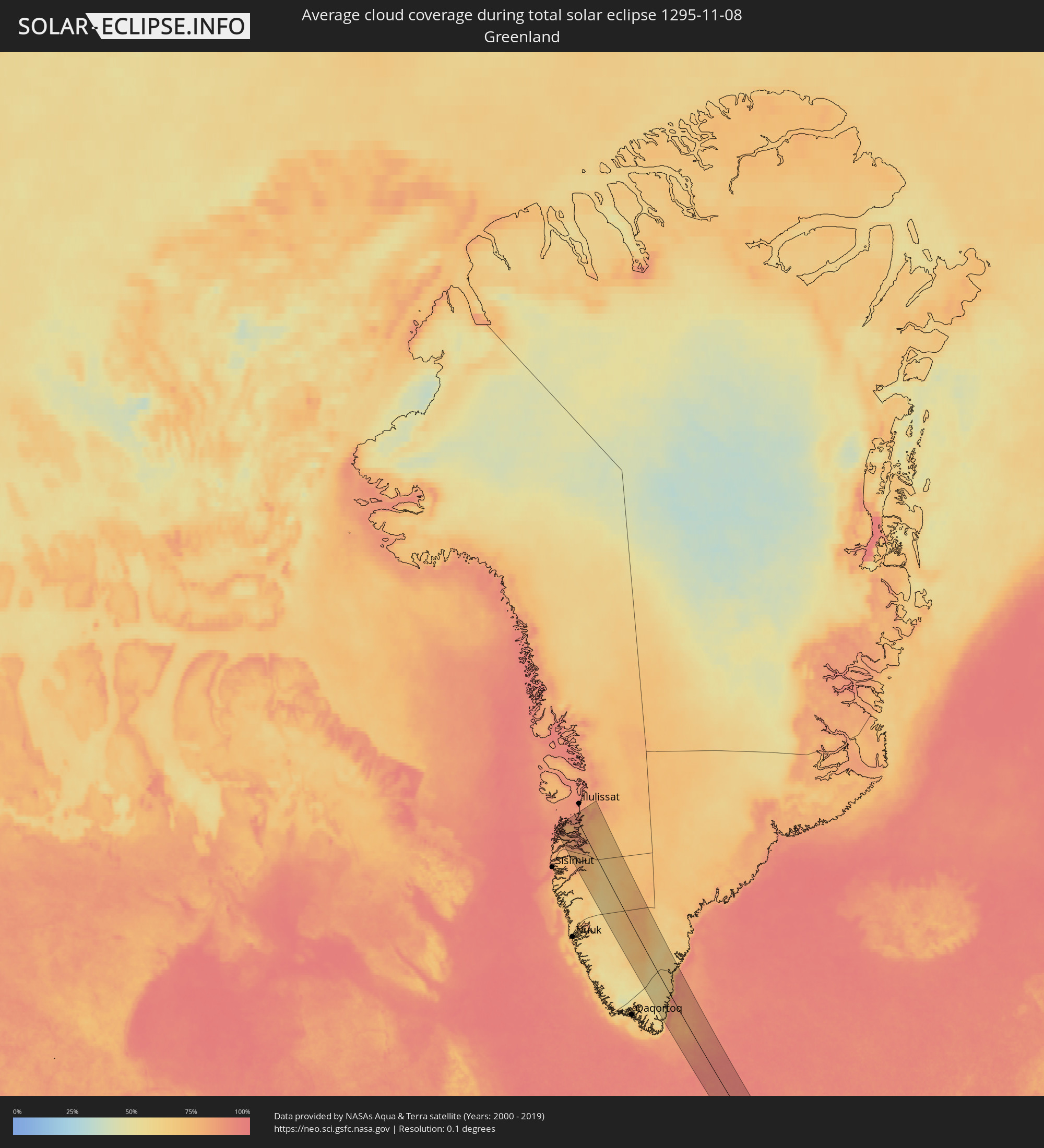 Grönland
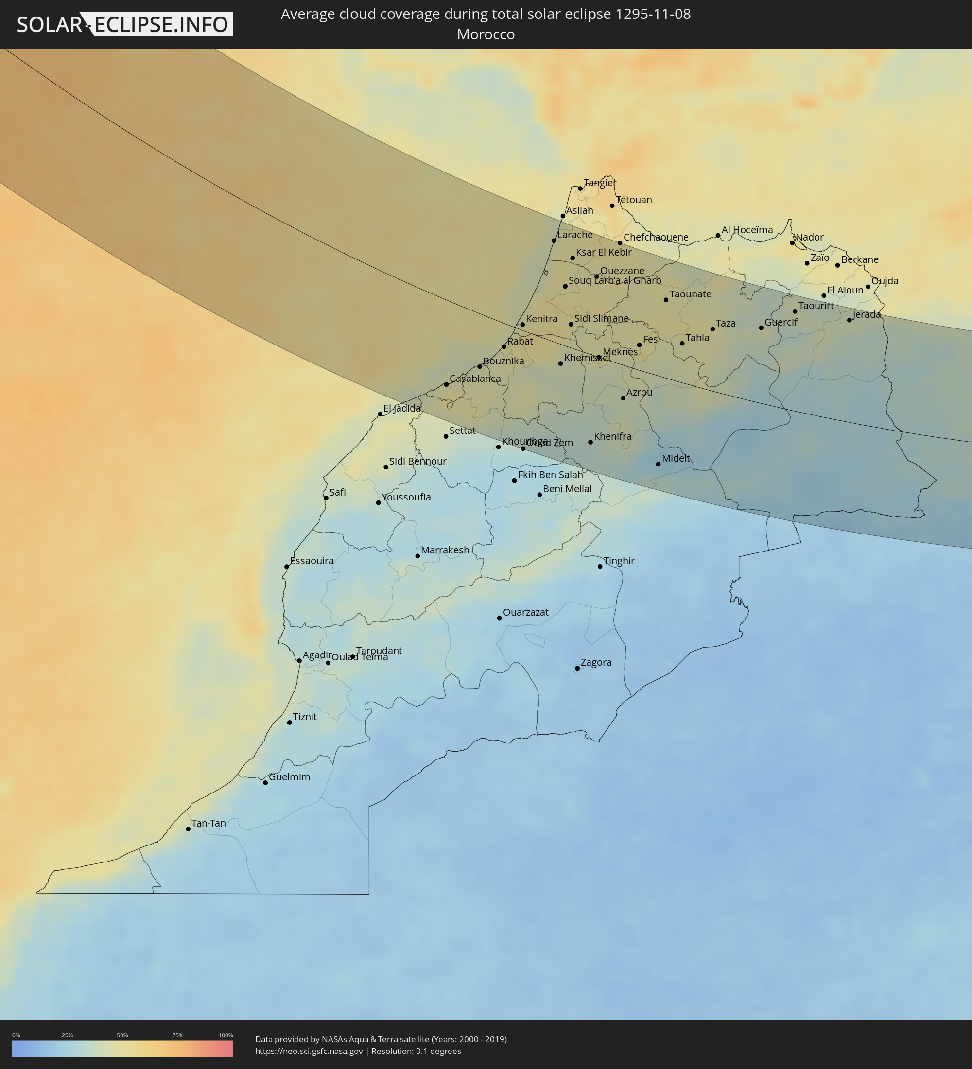 Marokko
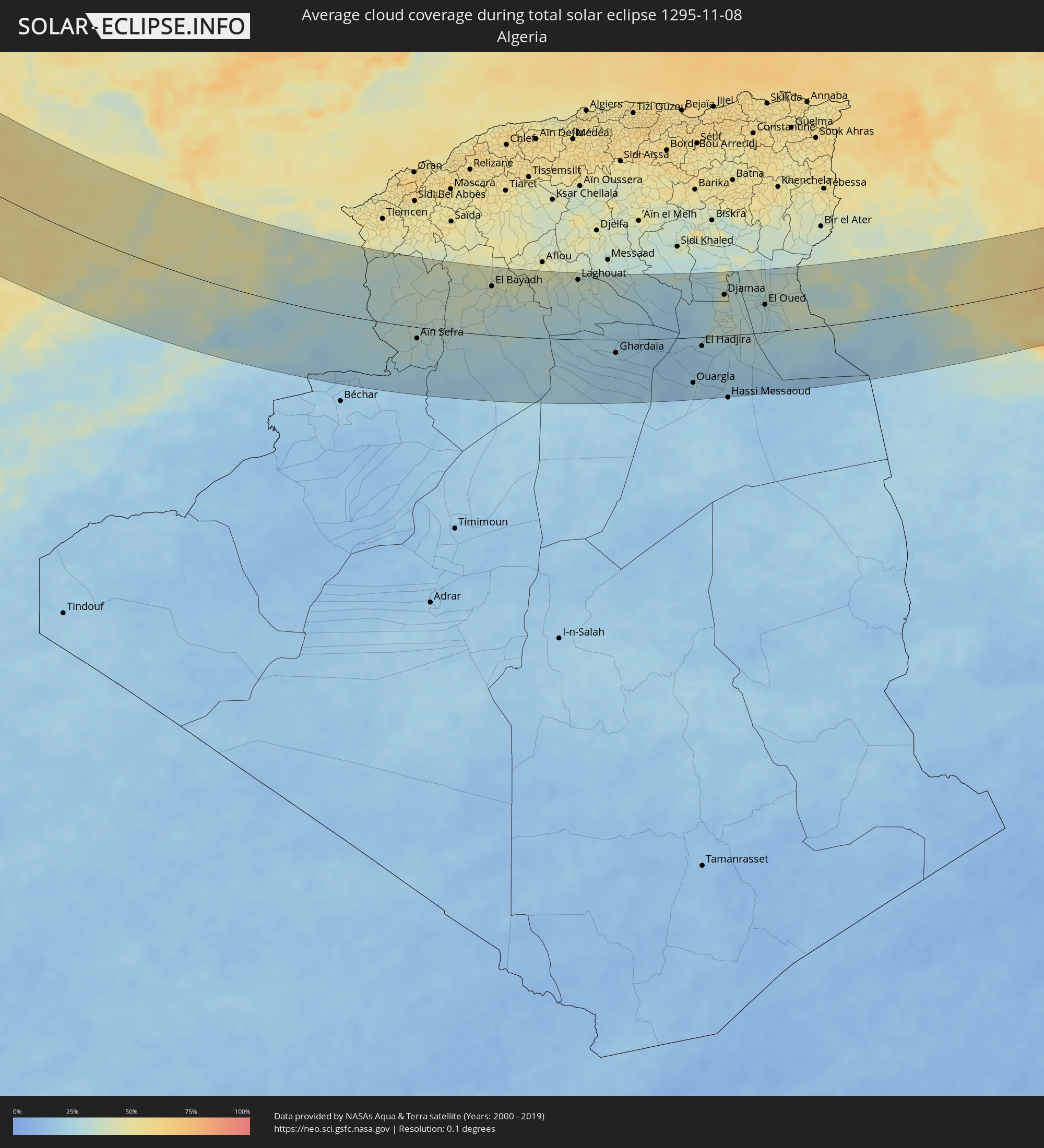 Algerien
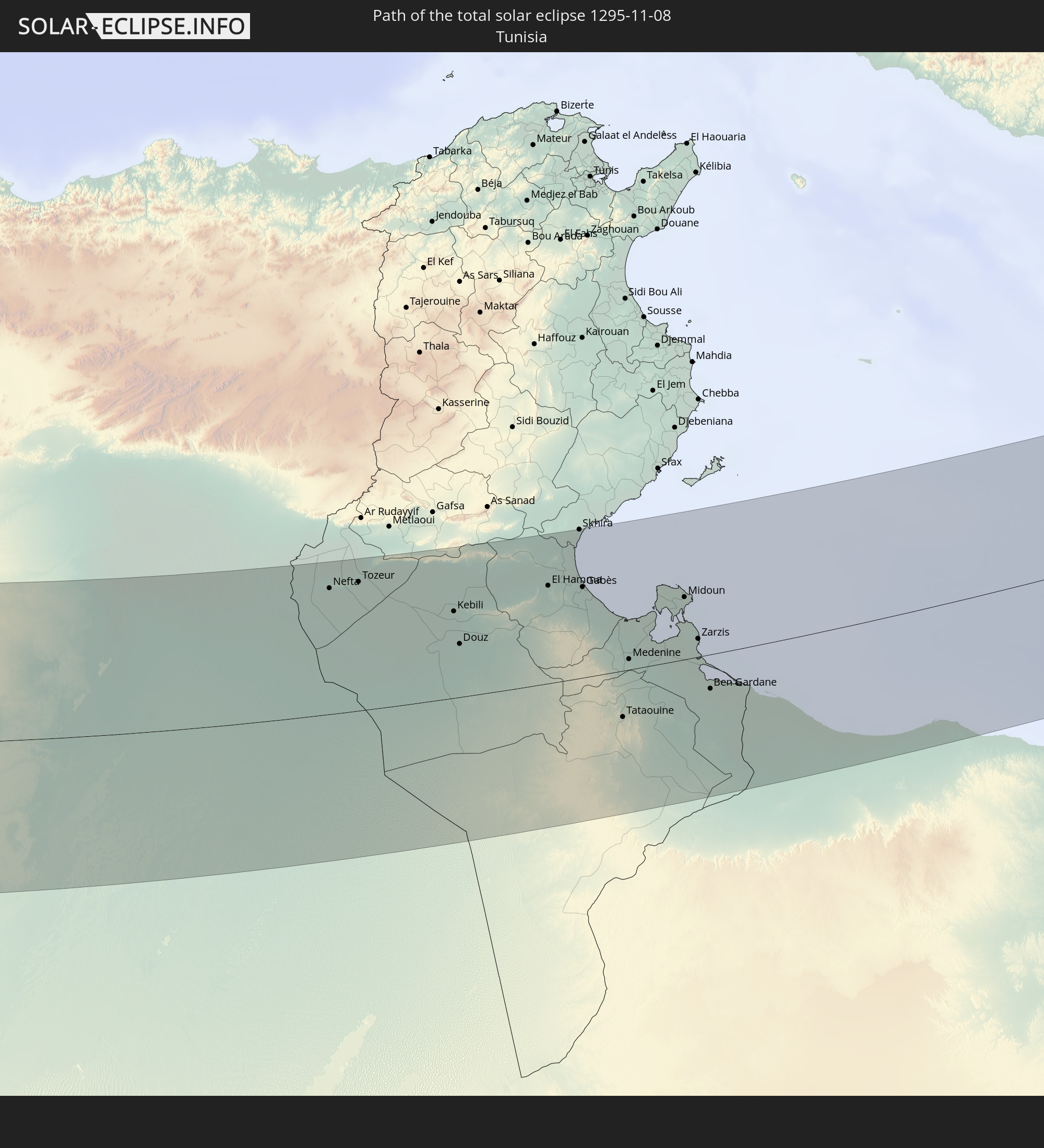
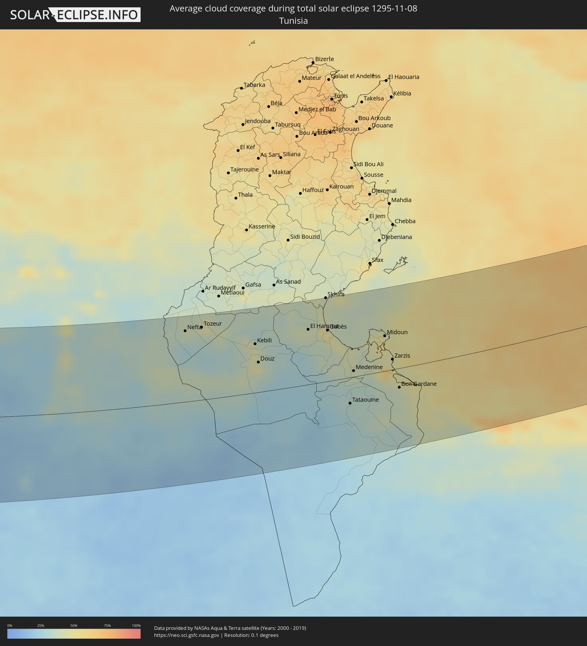 Tunesien
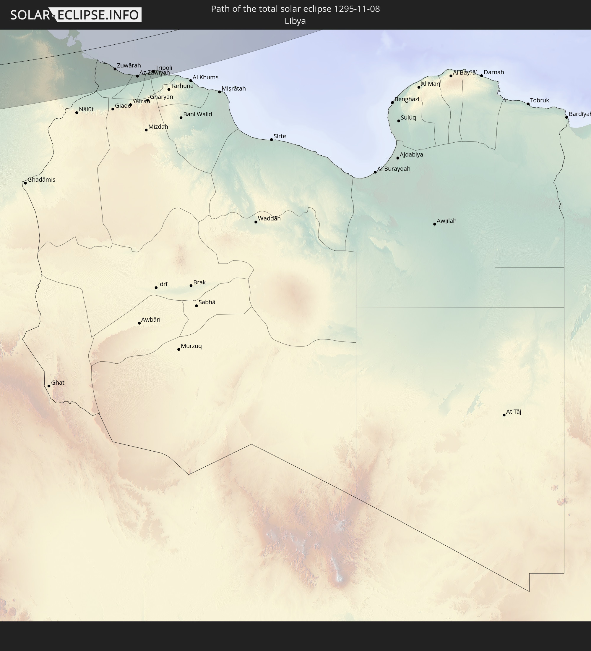
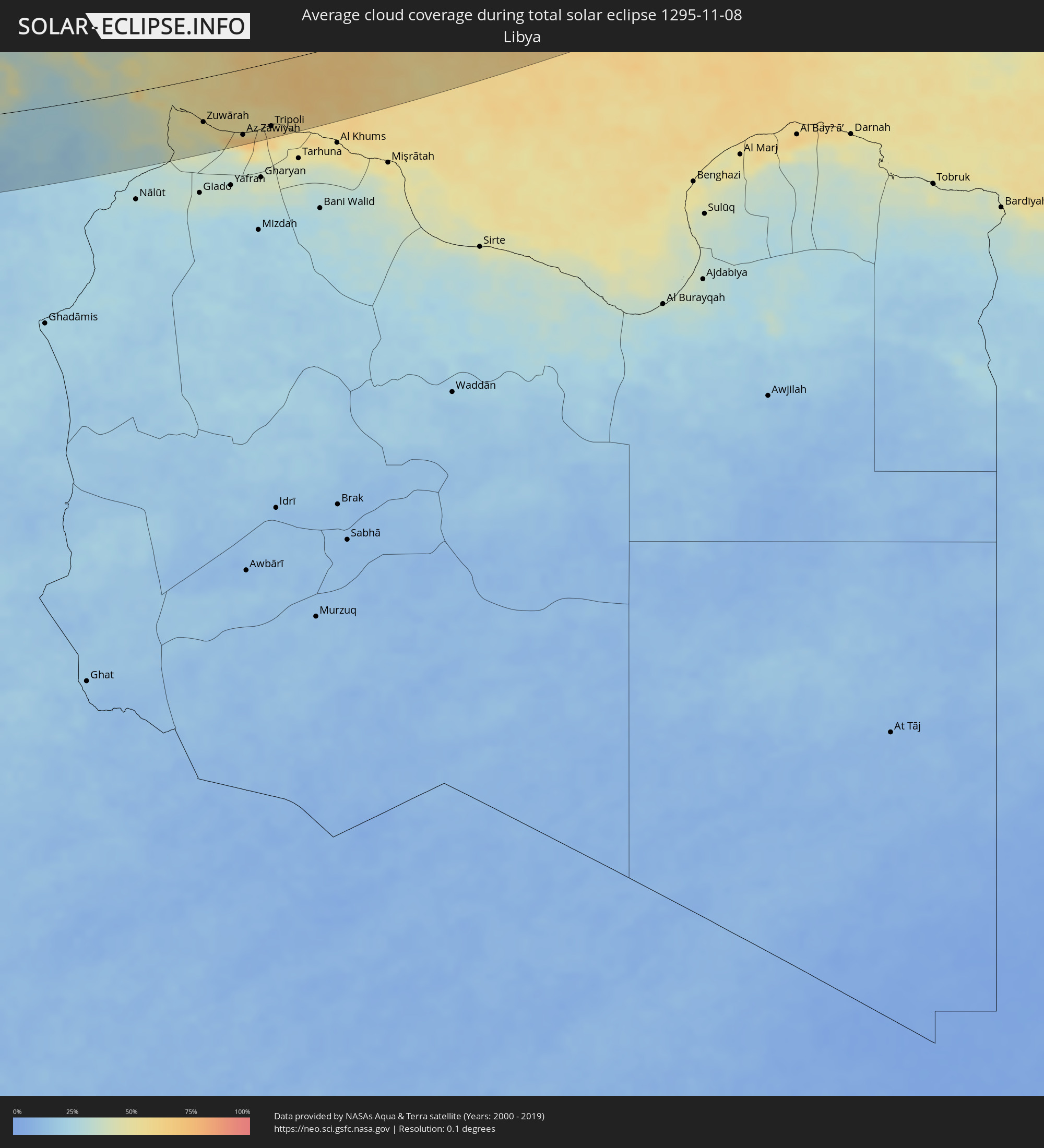 Libyen
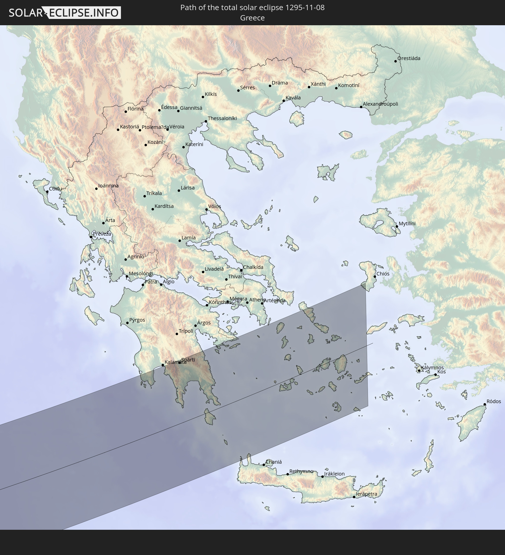
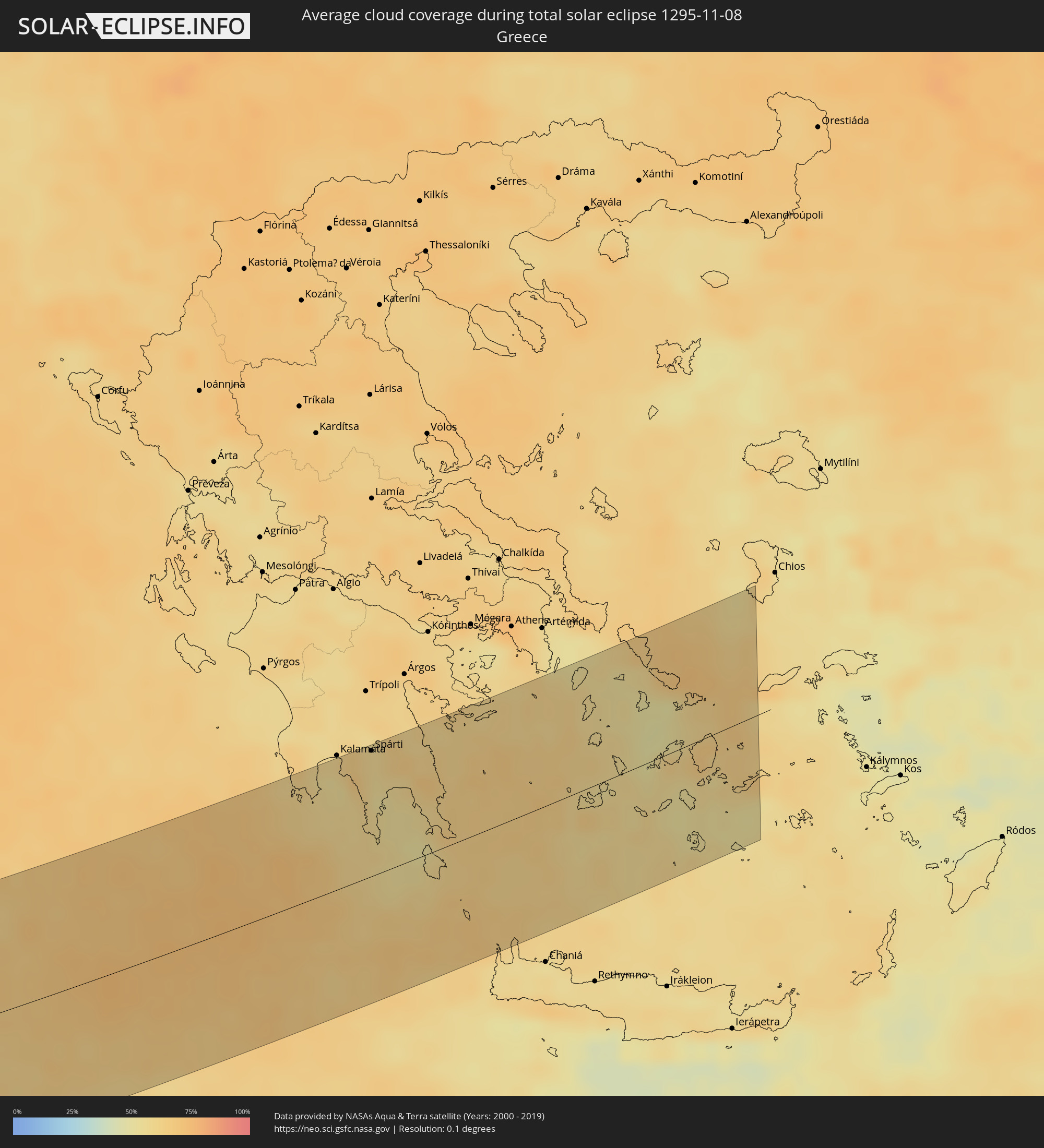 Griechenland
Orte im Finsternispfad
Die nachfolgene Tabelle zeigt Städte und Orte mit mehr als 5.000 Einwohnern, die sich im Finsternispfad befinden. Städte mit mehr als 100.000 Einwohnern sind dick gekennzeichnet. Mit einem Klick auf den Ort öffnet sich eine Detailkarte die die Lage des jeweiligen Ortes zusammen mit dem Verlauf der zentralen Finsternis präsentiert.
| Ort | Typ | Dauer der Verfinsterung | Ortszeit bei maximaler Verfinsterung | Entfernung zur Zentrallinie | Ø Bewölkung |
|
Nouaseur, Chaouia-Ouardigha
|
total | - | 13:56:33 UTC-00:30 | 120 km | 44% |
|
Casablanca, Grand Casablanca
|
total | - | 13:56:17 UTC-00:30 | 98 km | 50% |
|
Berrechid, Chaouia-Ouardigha
|
total | - | 13:56:46 UTC-00:30 | 131 km | 43% |
|
Mohammedia, Grand Casablanca
|
total | - | 13:56:34 UTC-00:30 | 80 km | 46% |
|
Bouznika, Chaouia-Ouardigha
|
total | - | 13:56:49 UTC-00:30 | 62 km | 45% |
|
Skhirate, Rabat-Salé-Zemmour-Zaër
|
total | - | 13:56:58 UTC-00:30 | 51 km | 46% |
|
Rabat, Rabat-Salé-Zemmour-Zaër
|
total | - | 13:57:06 UTC-00:30 | 28 km | 48% |
|
Sale, Rabat-Salé-Zemmour-Zaër
|
total | - | 13:57:06 UTC-00:30 | 23 km | 48% |
|
Kenitra, Gharb-Chrarda-Beni Hssen
|
total | - | 13:57:13 UTC-00:30 | 6 km | 51% |
|
Tiflet, Rabat-Salé-Zemmour-Zaër
|
total | - | 13:58:13 UTC-00:30 | 23 km | 41% |
|
Sidi Yahia El Gharb, Gharb-Chrarda-Beni Hssen
|
total | - | 13:57:39 UTC-00:30 | 20 km | 54% |
|
Larache, Tanger-Tétouan
|
total | - | 13:56:39 UTC-00:30 | 117 km | 46% |
|
Khemisset, Rabat-Salé-Zemmour-Zaër
|
total | - | 13:58:45 UTC-00:30 | 23 km | 39% |
|
Souq Larb’a al Gharb, Gharb-Chrarda-Beni Hssen
|
total | - | 13:57:38 UTC-00:30 | 69 km | 49% |
|
Mechraa Bel Ksiri, Gharb-Chrarda-Beni Hssen
|
total | - | 13:57:53 UTC-00:30 | 59 km | 50% |
|
Sidi Slimane, Gharb-Chrarda-Beni Hssen
|
total | - | 13:58:22 UTC-00:30 | 27 km | 44% |
|
Ksar El Kebir, Tanger-Tétouan
|
total | - | 13:57:22 UTC-00:30 | 105 km | 47% |
|
Sidi Qacem, Gharb-Chrarda-Beni Hssen
|
total | - | 13:58:49 UTC-00:30 | 29 km | 47% |
|
Khenifra, Meknès-Tafilalet
|
total | - | 14:00:44 UTC-00:30 | 105 km | 33% |
|
Ouezzane, Gharb-Chrarda-Beni Hssen
|
total | - | 13:58:14 UTC-00:30 | 94 km | 48% |
|
Meknès, Meknès-Tafilalet
|
total | - | 13:59:34 UTC-00:30 | 1 km | 42% |
|
El Hajeb, Meknès-Tafilalet
|
total | - | 14:00:11 UTC-00:30 | 17 km | 39% |
|
Chefchaouene, Tanger-Tétouan
|
total | - | 13:58:15 UTC-00:30 | 142 km | 50% |
|
Azrou, Meknès-Tafilalet
|
total | - | 14:00:48 UTC-00:30 | 40 km | 40% |
|
Fes, Fès-Boulemane
|
total | - | 14:00:20 UTC-00:30 | 30 km | 44% |
|
Fès al Bali, Fès-Boulemane
|
total | - | 14:00:22 UTC-00:30 | 35 km | 51% |
|
Sefrou, Fès-Boulemane
|
total | - | 14:00:56 UTC-00:30 | 13 km | 41% |
|
Midelt, Meknès-Tafilalet
|
total | - | 14:02:43 UTC-00:30 | 108 km | 27% |
|
Taounate, Taza-Al Hoceima-Taounate
|
total | - | 14:00:15 UTC-00:30 | 93 km | 47% |
|
Tahla, Taza-Al Hoceima-Taounate
|
total | - | 14:01:19 UTC-00:30 | 47 km | 45% |
|
Taza, Taza-Al Hoceima-Taounate
|
total | - | 14:01:48 UTC-00:30 | 74 km | 45% |
|
Guercif, Taza-Al Hoceima-Taounate
|
total | - | 14:02:54 UTC-00:30 | 91 km | 38% |
|
Taourirt, Oriental
|
total | - | 14:03:25 UTC-00:30 | 121 km | 39% |
|
Jerada, Oriental
|
total | - | 14:04:47 UTC-00:30 | 125 km | 37% |
|
Figuig (Centre), Oriental
|
total | - | 14:09:33 UTC-00:30 | 101 km | 24% |
|
Aïn Sefra, Naama
|
total | - | 14:49:21 UTC+00:09 | 22 km | 32% |
|
Naama, Naama
|
total | - | 14:49:01 UTC+00:09 | 38 km | 37% |
|
El Abiodh Sidi Cheikh, El Bayadh
|
total | - | 14:50:56 UTC+00:09 | 5 km | 29% |
|
El Bayadh, El Bayadh
|
total | - | 14:50:30 UTC+00:09 | 97 km | 39% |
|
Brezina, El Bayadh
|
total | - | 14:51:44 UTC+00:09 | 34 km | 33% |
|
Laghouat, Laghouat
|
total | - | 14:53:06 UTC+00:09 | 119 km | 39% |
|
Metlili Chaamba, Ghardaia
|
total | - | 14:56:32 UTC+00:09 | 51 km | 21% |
|
Ghardaïa, Ghardaia
|
total | - | 14:56:15 UTC+00:09 | 26 km | 24% |
|
Berriane, Ghardaia
|
total | - | 14:55:53 UTC+00:09 | 11 km | 22% |
|
Ouargla, Ouargla
|
total | - | 14:59:23 UTC+00:09 | 91 km | 21% |
|
Rouissat, Ouargla
|
total | - | 14:59:27 UTC+00:09 | 94 km | 22% |
|
El Hadjira, Ouargla
|
total | - | 14:58:39 UTC+00:09 | 18 km | 20% |
|
Djamaa, Ouargla
|
total | - | 14:57:54 UTC+00:09 | 81 km | 37% |
|
Sidi Amrane, Ouargla
|
total | - | 14:57:59 UTC+00:09 | 77 km | 37% |
|
Touggourt, Ouargla
|
total | - | 14:58:39 UTC+00:09 | 33 km | 34% |
|
Tebesbest, Ouargla
|
total | - | 14:58:40 UTC+00:09 | 34 km | 34% |
|
Megarine, Ouargla
|
total | - | 14:58:33 UTC+00:09 | 43 km | 38% |
|
Reguiba, El Oued
|
total | - | 14:58:48 UTC+00:09 | 79 km | 29% |
|
El Oued, El Oued
|
total | - | 14:59:20 UTC+00:09 | 55 km | 31% |
|
Robbah, El Oued
|
total | - | 14:59:30 UTC+00:09 | 46 km | 29% |
|
Debila, El Oued
|
total | - | 14:59:12 UTC+00:09 | 72 km | 32% |
|
Nefta, Tawzar
|
total | - | 14:59:50 UTC+00:09 | 102 km | 39% |
|
Tozeur, Tawzar
|
total | - | 15:00:05 UTC+00:09 | 104 km | 35% |
|
Degache, Tawzar
|
total | - | 15:00:06 UTC+00:09 | 110 km | 45% |
|
Kebili, Qibilī
|
total | - | 15:01:27 UTC+00:09 | 70 km | 43% |
|
El Golaa, Qibilī
|
total | - | 15:01:50 UTC+00:09 | 45 km | 47% |
|
Jemna, Qibilī
|
total | - | 15:01:42 UTC+00:09 | 55 km | 43% |
|
Douz, Qibilī
|
total | - | 15:01:52 UTC+00:09 | 43 km | 47% |
|
El Hamma, Qābis
|
total | - | 15:02:09 UTC+00:09 | 79 km | 40% |
|
Skhira, Şafāqis
|
total | - | 15:01:51 UTC+00:09 | 119 km | 41% |
|
Gabès, Qābis
|
total | - | 15:02:31 UTC+00:09 | 73 km | 52% |
|
Tataouine, Tataouine
|
total | - | 15:04:22 UTC+00:09 | 37 km | 31% |
|
Medenine, Madanīn
|
total | - | 15:03:47 UTC+00:09 | 9 km | 40% |
|
Houmt Souk, Madanīn
|
total | - | 15:03:24 UTC+00:09 | 60 km | 50% |
|
Midoun, Madanīn
|
total | - | 15:03:39 UTC+00:09 | 50 km | 50% |
|
Zarzis, Madanīn
|
total | - | 15:04:15 UTC+00:09 | 14 km | 52% |
|
Ben Gardane, Madanīn
|
total | - | 15:04:56 UTC+00:09 | 27 km | 38% |
|
Zalţan, An Nuqāţ al Khams
|
total | - | 15:49:19 UTC+00:52 | 60 km | 44% |
|
Zuwārah, An Nuqāţ al Khams
|
total | - | 15:49:34 UTC+00:52 | 66 km | 47% |
|
Şabrātah, Az Zāwiyah
|
total | - | 15:50:12 UTC+00:52 | 89 km | 66% |
|
Şurmān, Az Zāwiyah
|
total | - | 15:50:21 UTC+00:52 | 94 km | 66% |
|
Az Zāwīyah, Az Zāwiyah
|
total | - | 15:50:31 UTC+00:52 | 97 km | 67% |
|
Zawiya, Az Zāwiyah
|
total | - | 15:50:31 UTC+00:52 | 98 km | 67% |
|
Tripoli, Tripoli
|
total | - | 15:50:49 UTC+00:52 | 94 km | 62% |
|
Tagiura, Tripoli
|
total | - | 15:50:58 UTC+00:52 | 97 km | 59% |
|
Spárti, Peloponnese
|
total | - | 16:34:21 UTC+01:34 | 96 km | 60% |
|
Ermoúpolis, South Aegean
|
total | - | 16:35:21 UTC+01:34 | 47 km | 52% |
|
Páros, South Aegean
|
total | - | 16:36:02 UTC+01:34 | 4 km | 62% |
|
Náxos, South Aegean
|
total | - | 16:36:07 UTC+01:34 | 2 km | 63% |