Totale Sonnenfinsternis vom 16.06.1406
| Wochentag: | Montag |
| Maximale Dauer der Verfinsterung: | 03m48s |
| Maximale Breite des Finsternispfades: | 283 km |
| Saroszyklus: | 127 |
| Bedeckungsgrad: | 100% |
| Magnitude: | 1.0596 |
| Gamma: | 0.7188 |
Wo kann man die Sonnenfinsternis vom 16.06.1406 sehen?
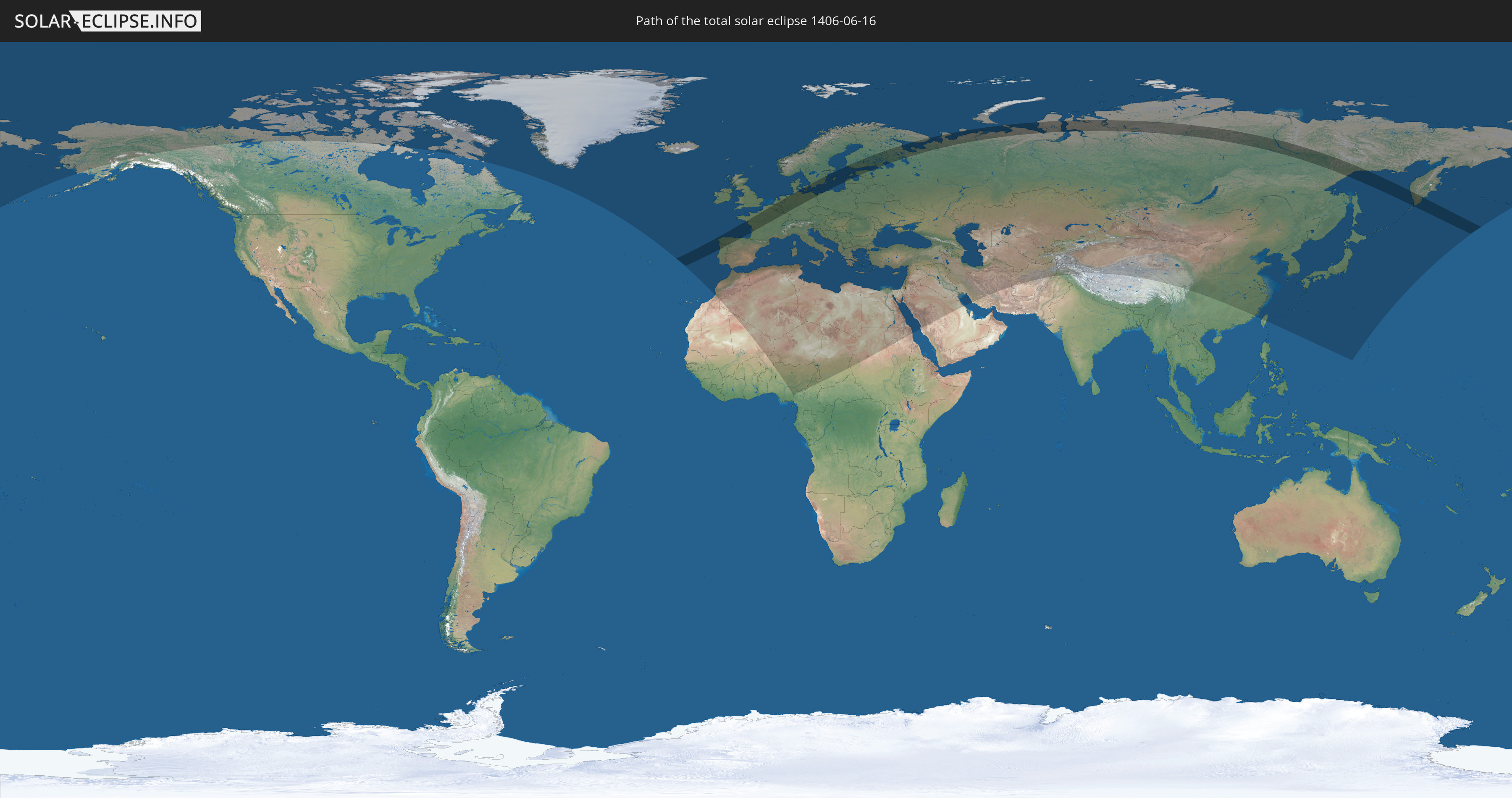
Die Sonnenfinsternis am 16.06.1406 kann man in 95 Ländern als partielle Sonnenfinsternis beobachten.
Der Finsternispfad verläuft durch 15 Länder. Nur in diesen Ländern ist sie als totale Sonnenfinsternis zu sehen.
In den folgenden Ländern ist die Sonnenfinsternis total zu sehen
 Russland
 Portugal
 Spanien
 Frankreich
 Belgien
 Niederlande
 Luxemburg
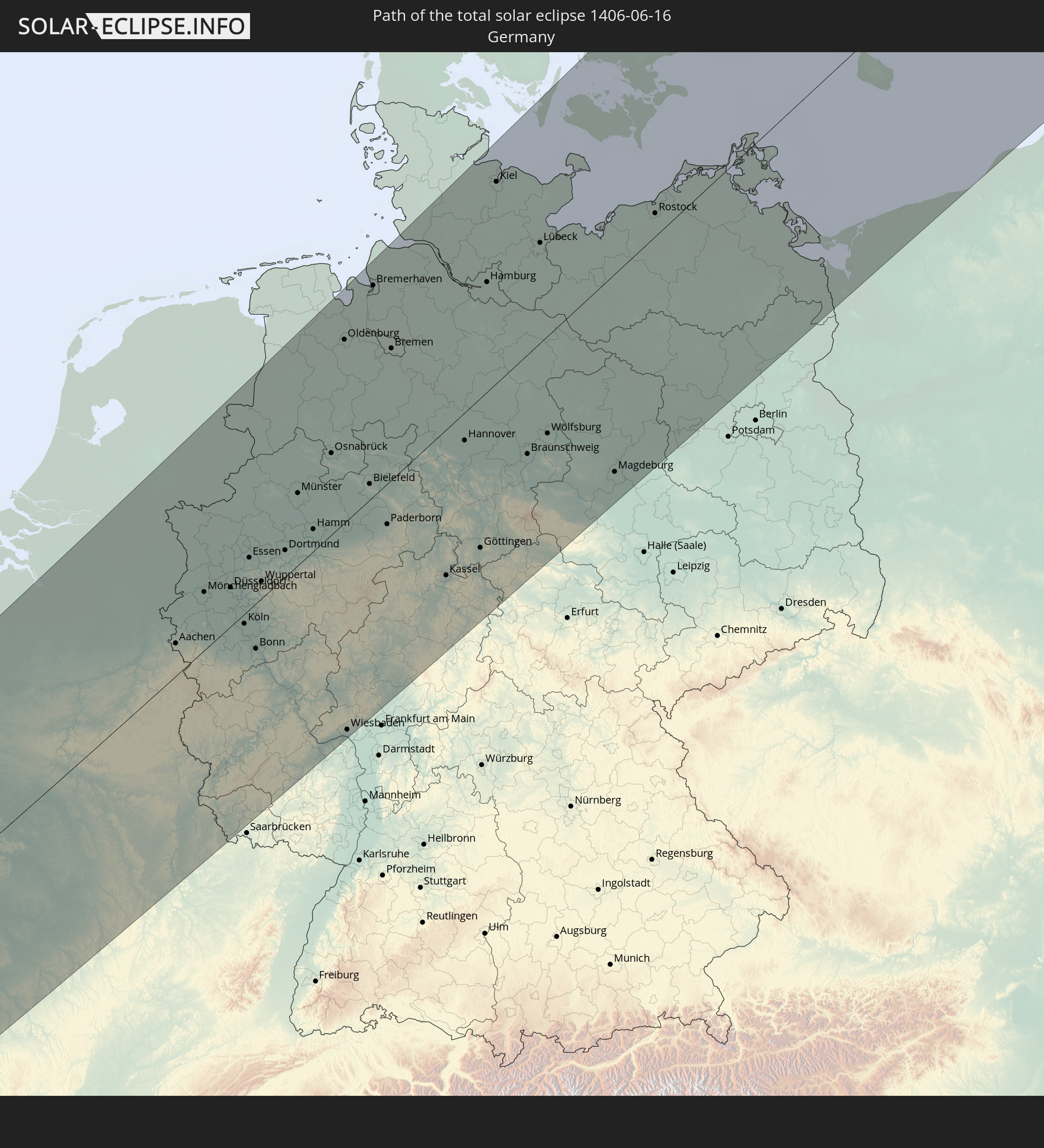 Deutschland
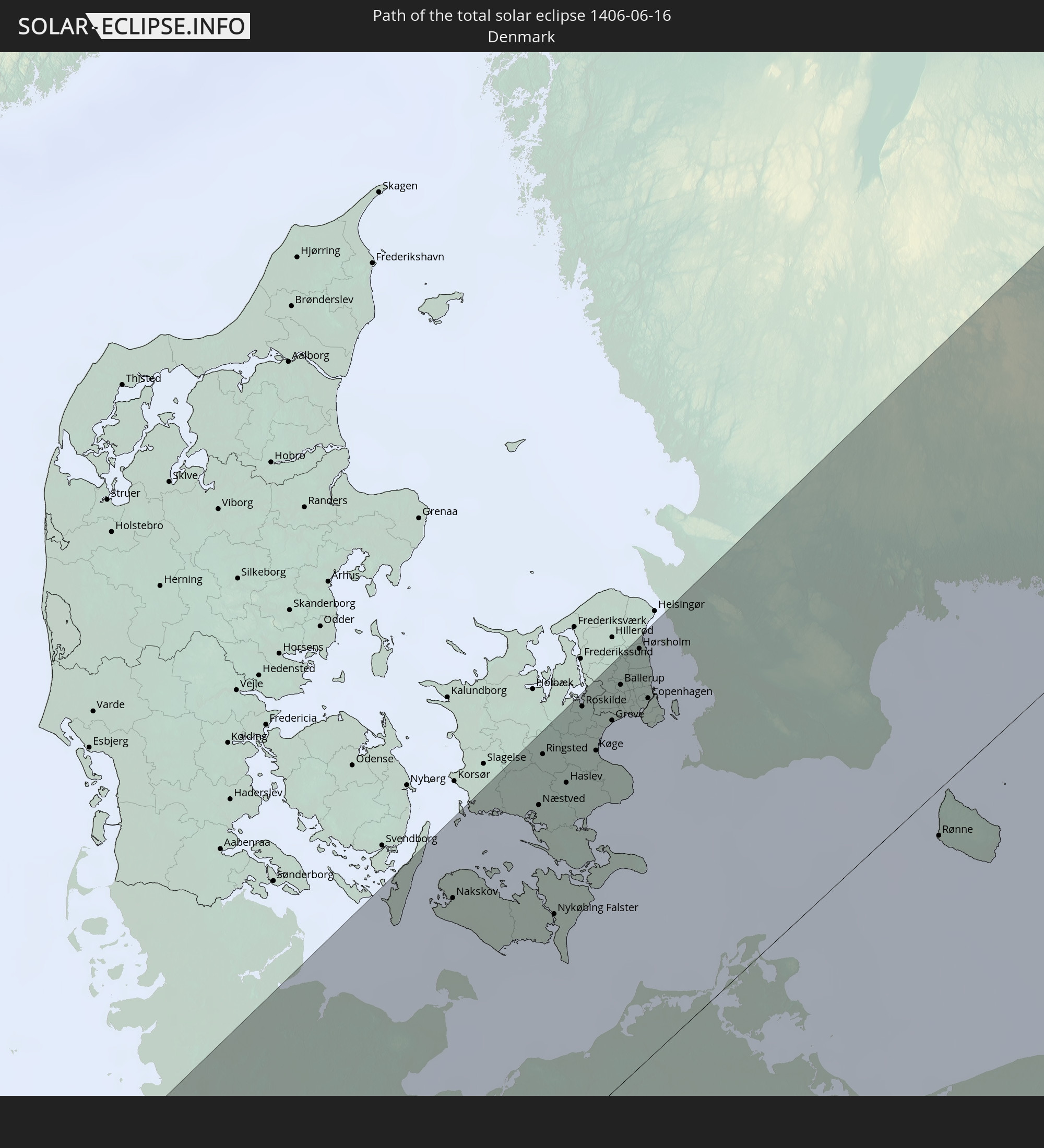 Dänemark
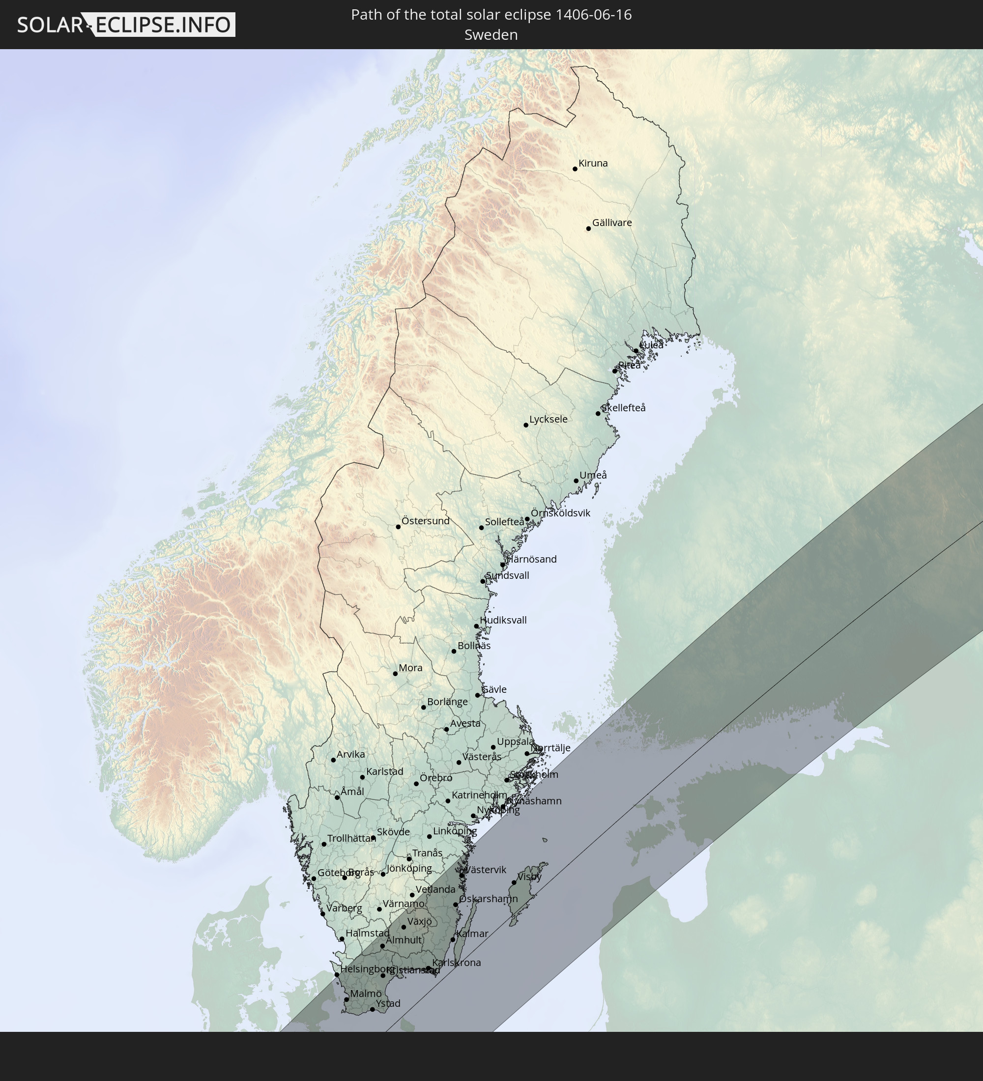 Schweden
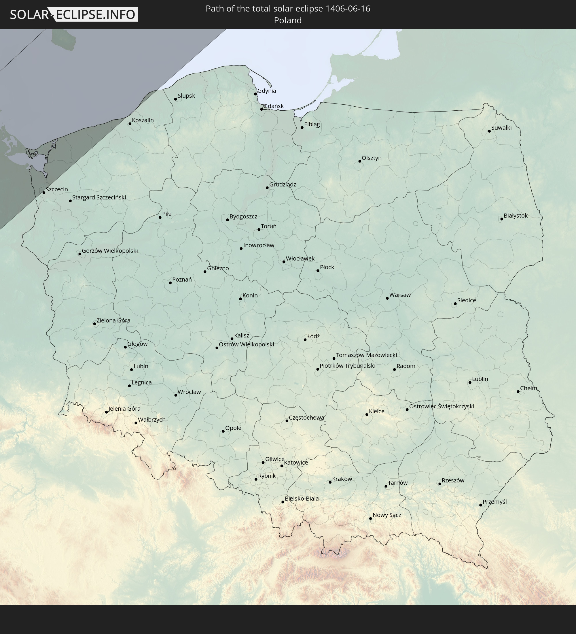 Polen
Polen
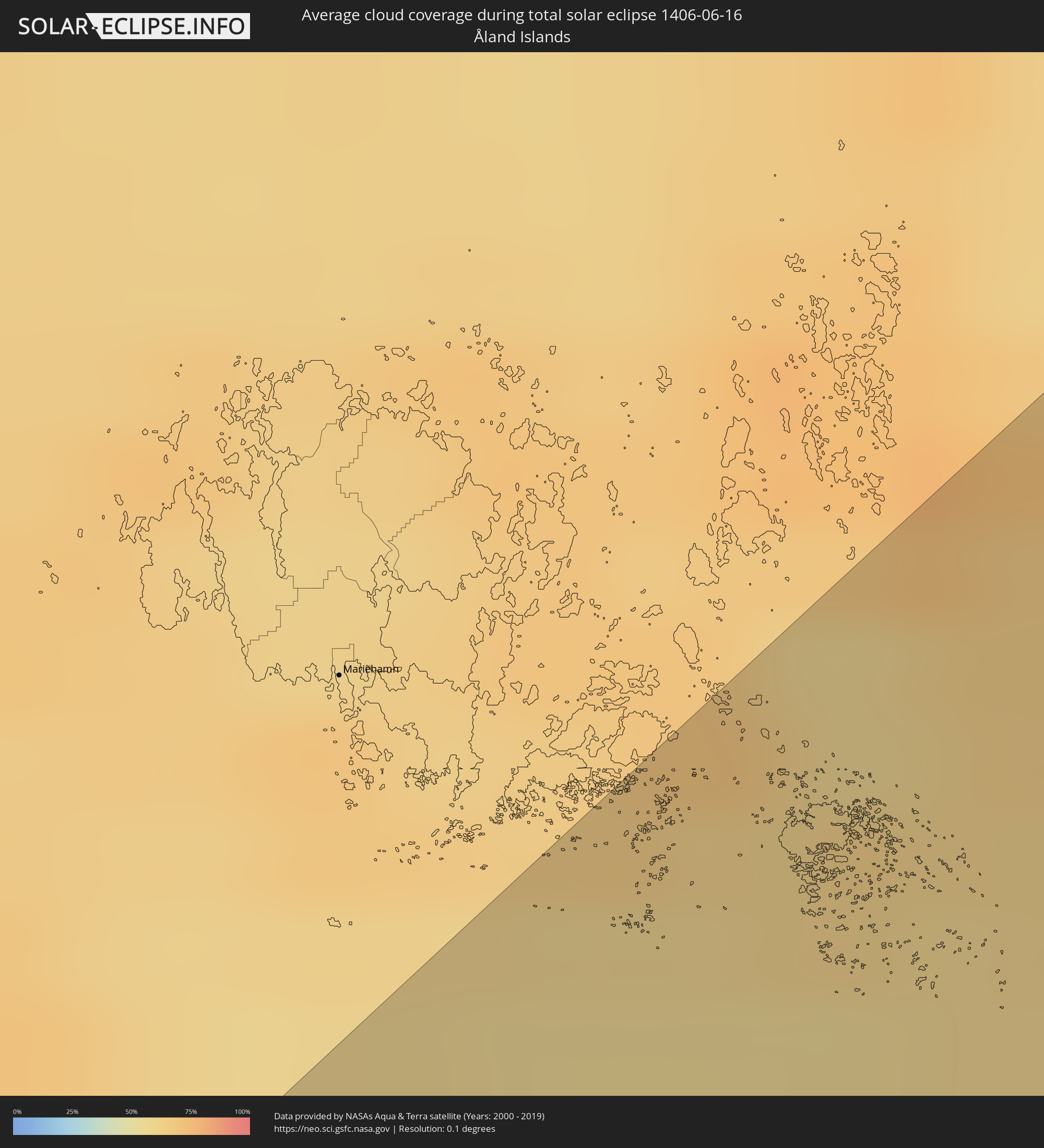
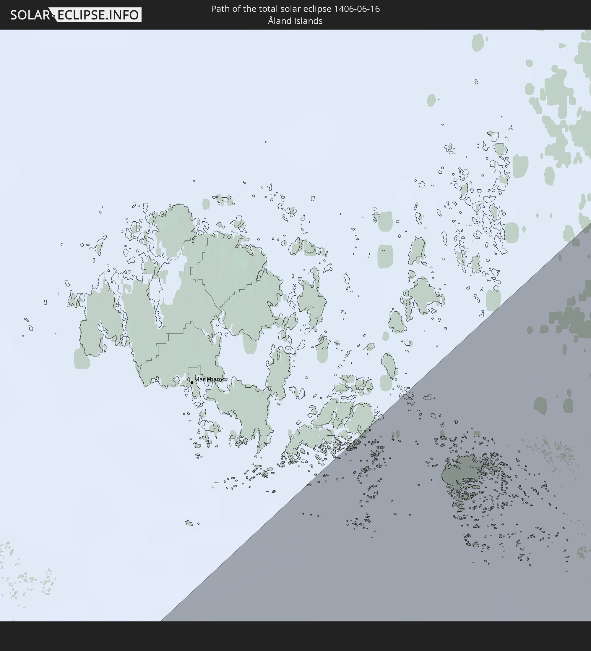 Åland Islands
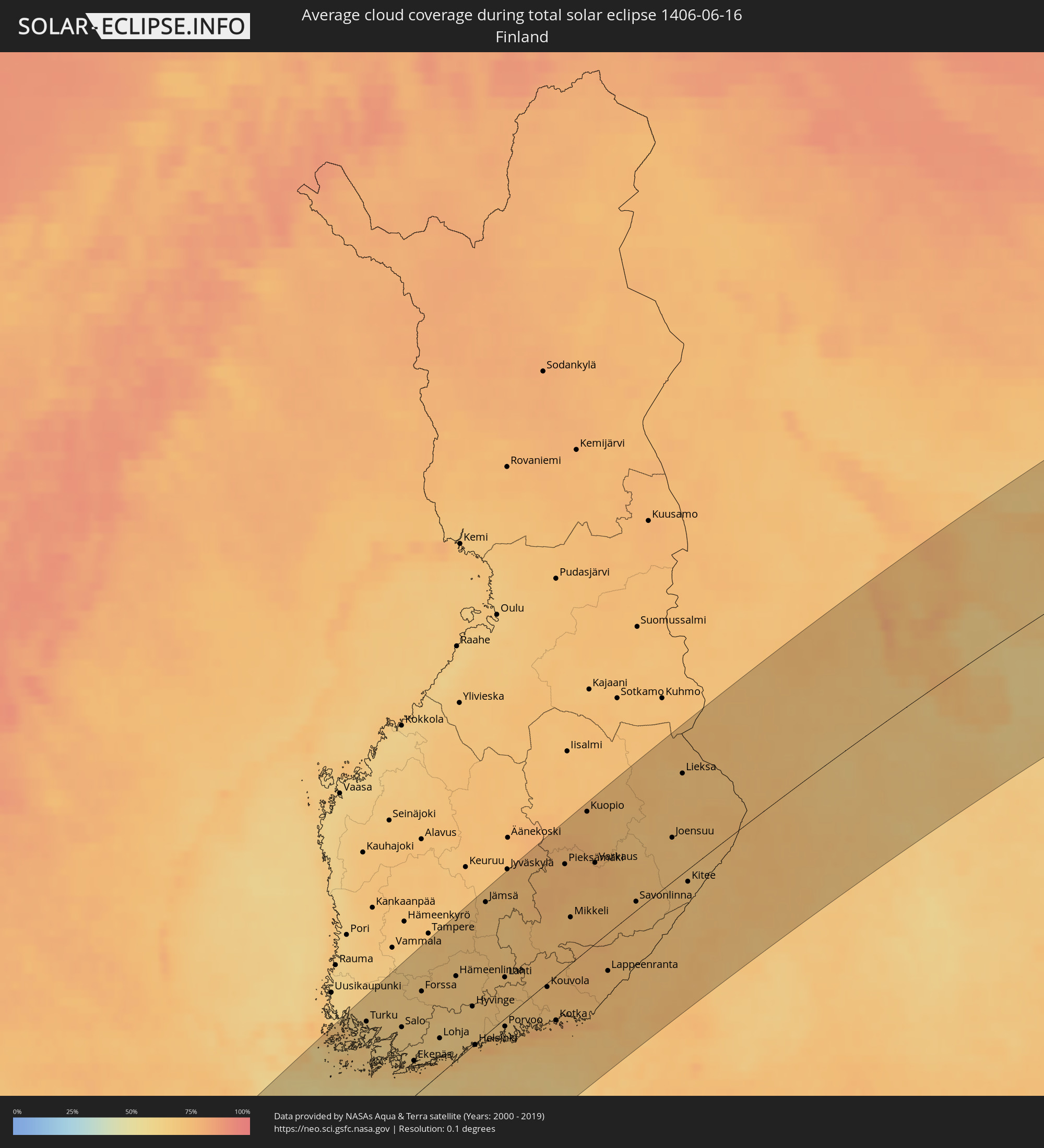
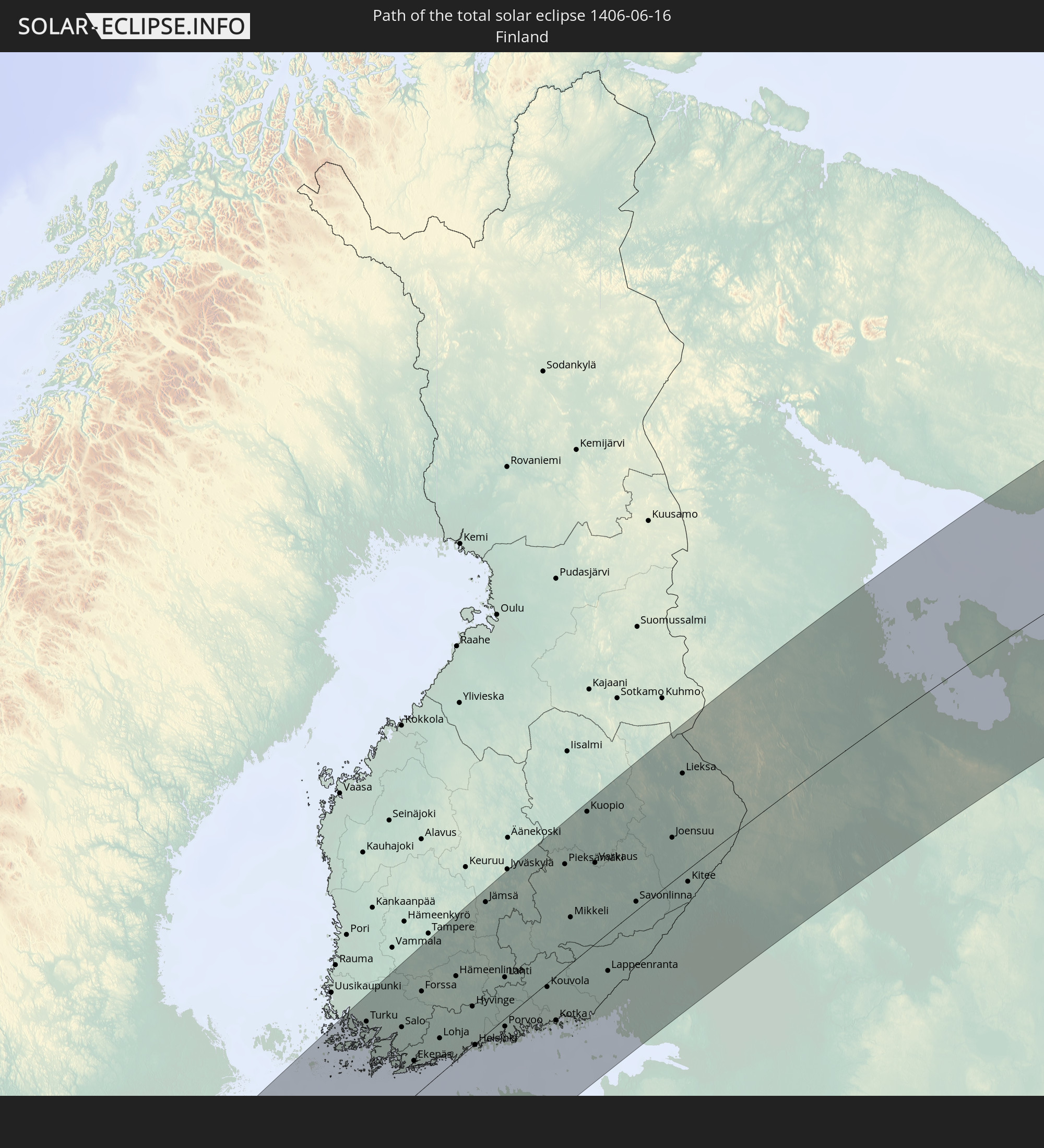 Finnland
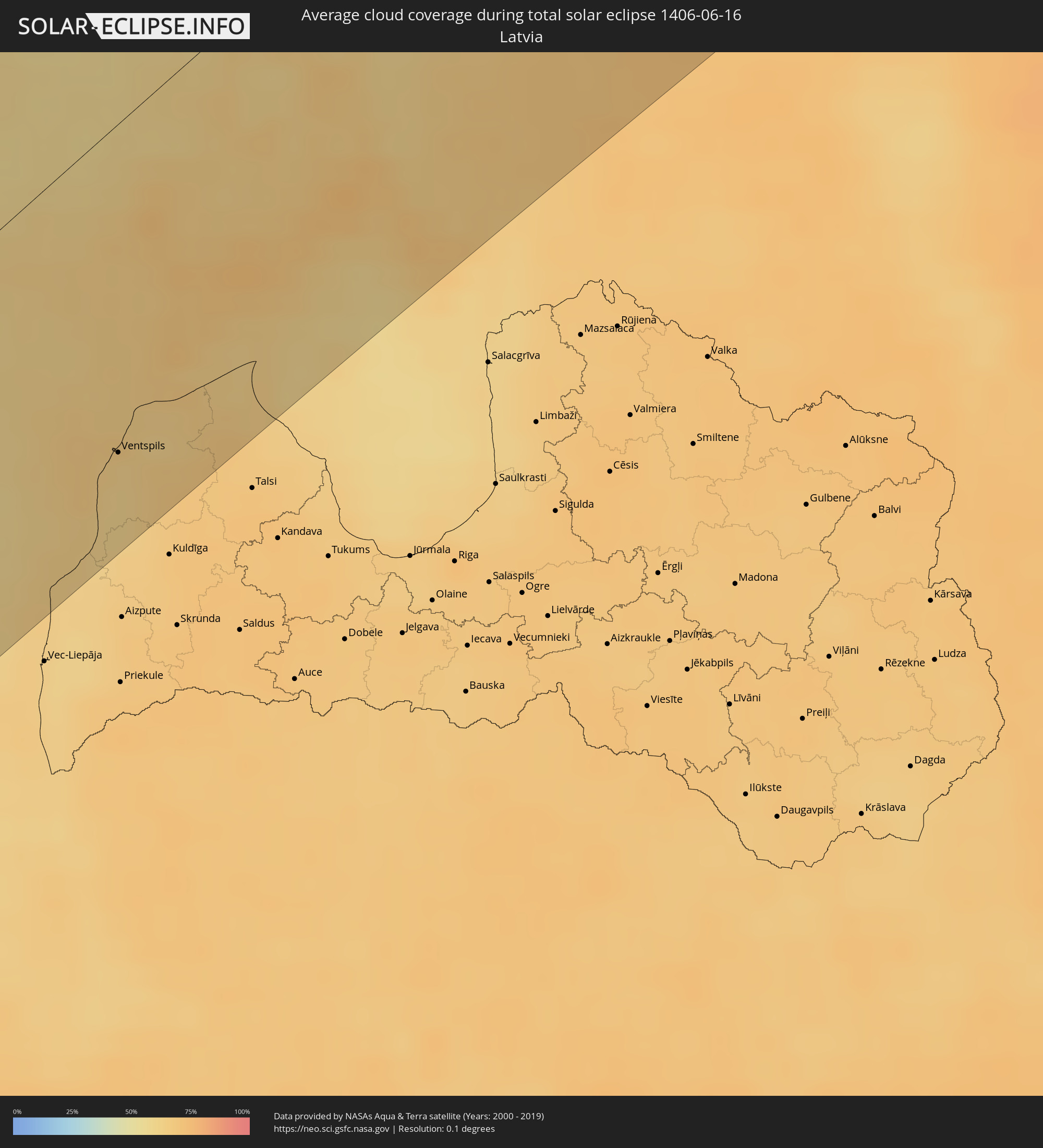
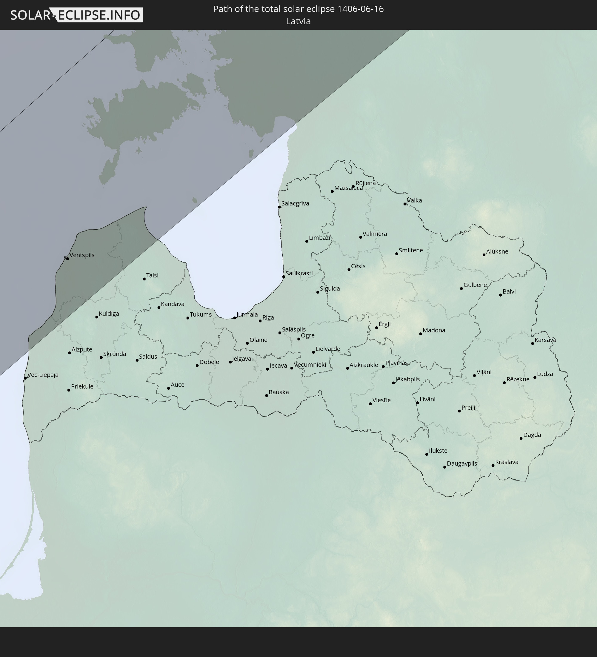 Lettland
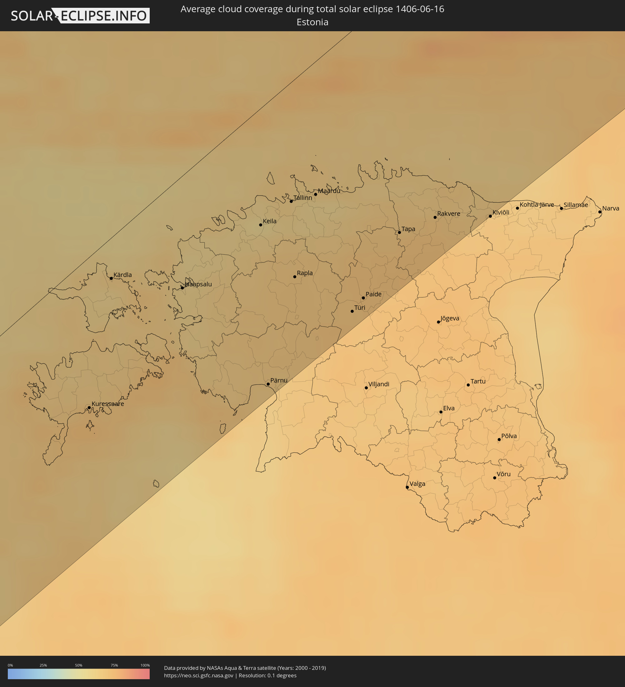
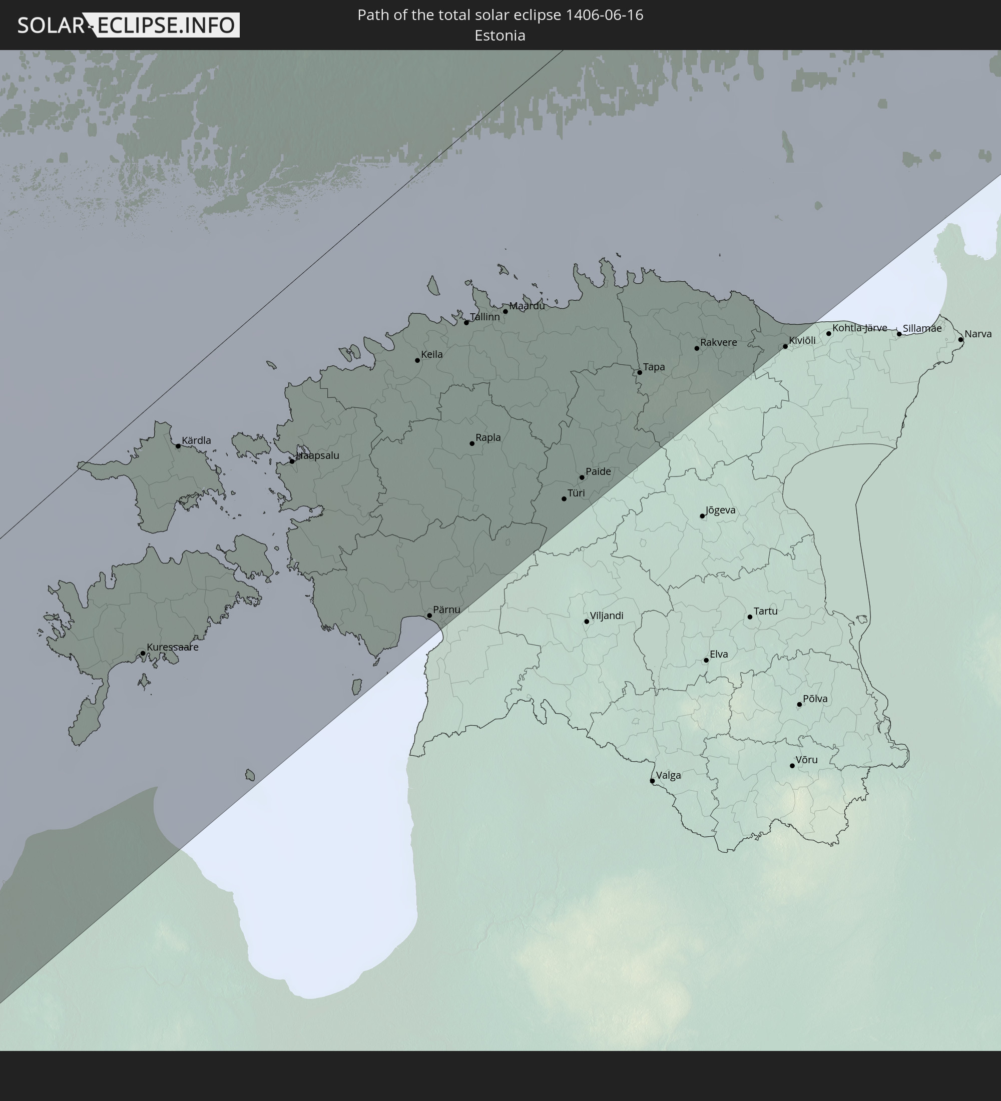 Estland
In den folgenden Ländern ist die Sonnenfinsternis partiell zu sehen
 Russland
 Vereinigte Staaten
 Kanada
 Grönland
 Portugal
 Island
 Spanien
 Mauretanien
 Marokko
 Mali
Mali
 Irland
 Spitzbergen
 Algerien
 Vereinigtes Königreich
 Färöer
 Gibraltar
 Frankreich
 Isle of Man
 Guernsey
 Jersey
 Niger
Niger
 Andorra
 Belgien
 Nigeria
 Niederlande
 Norwegen
 Luxemburg
 Deutschland
 Schweiz
 Italien
 Monaco
 Tunesien
 Dänemark
 Kamerun
 Libyen
 Liechtenstein
 Österreich
 Schweden
 Tschechien
 San Marino
 Vatikanstadt
 Slowenien
 Tschad
 Kroatien
 Polen
Polen
 Malta
Malta
 Bosnien und Herzegowina
 Ungarn
 Slowakei
 Montenegro
 Serbien
 Albanien
 Åland Islands
 Griechenland
 Rumänien
 Mazedonien
 Finnland
 Litauen
 Lettland
 Estland
 Sudan
Sudan
 Ukraine
 Bulgarien
 Weißrussland
 Ägypten
 Türkei
 Moldawien
 Republik Zypern
 Staat Palästina
 Israel
 Saudi-Arabien
 Jordanien
 Libanon
 Syrien
 Irak
Irak
 Georgien
 Armenien
 Iran
Iran
 Aserbaidschan
 Kasachstan
 Kuwait
 Turkmenistan
 Usbekistan
 Afghanistan
 Pakistan
 Tadschikistan
 Indien
 Kirgisistan
 Volksrepublik China
 Mongolei
 Taiwan
 Japan
Japan
 Nordkorea
 Südkorea
 Nördliche Marianen
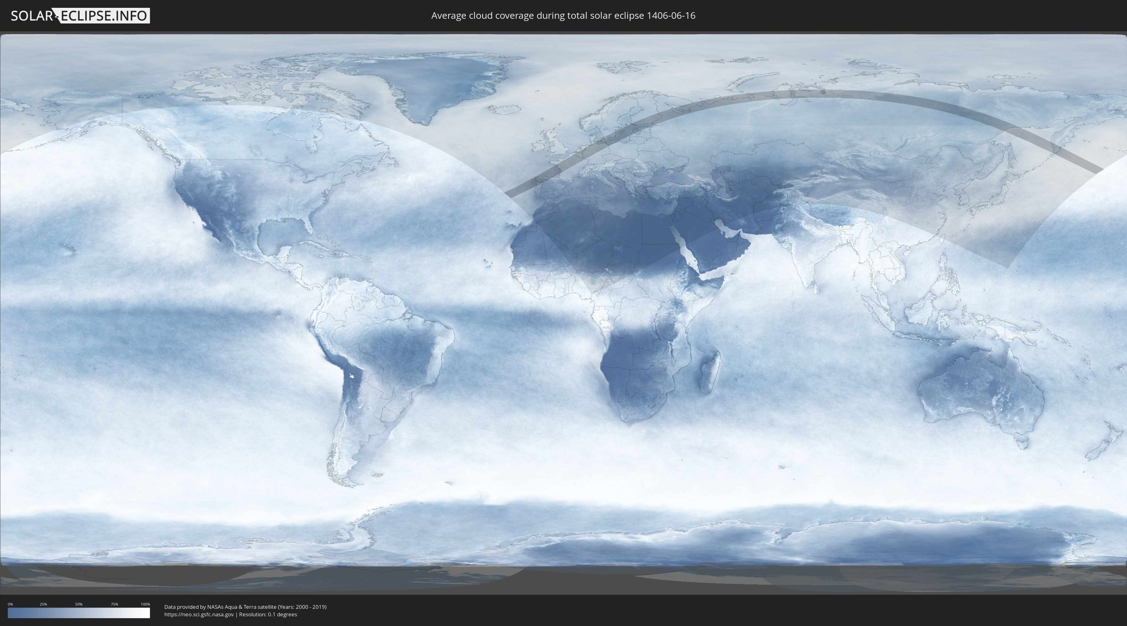
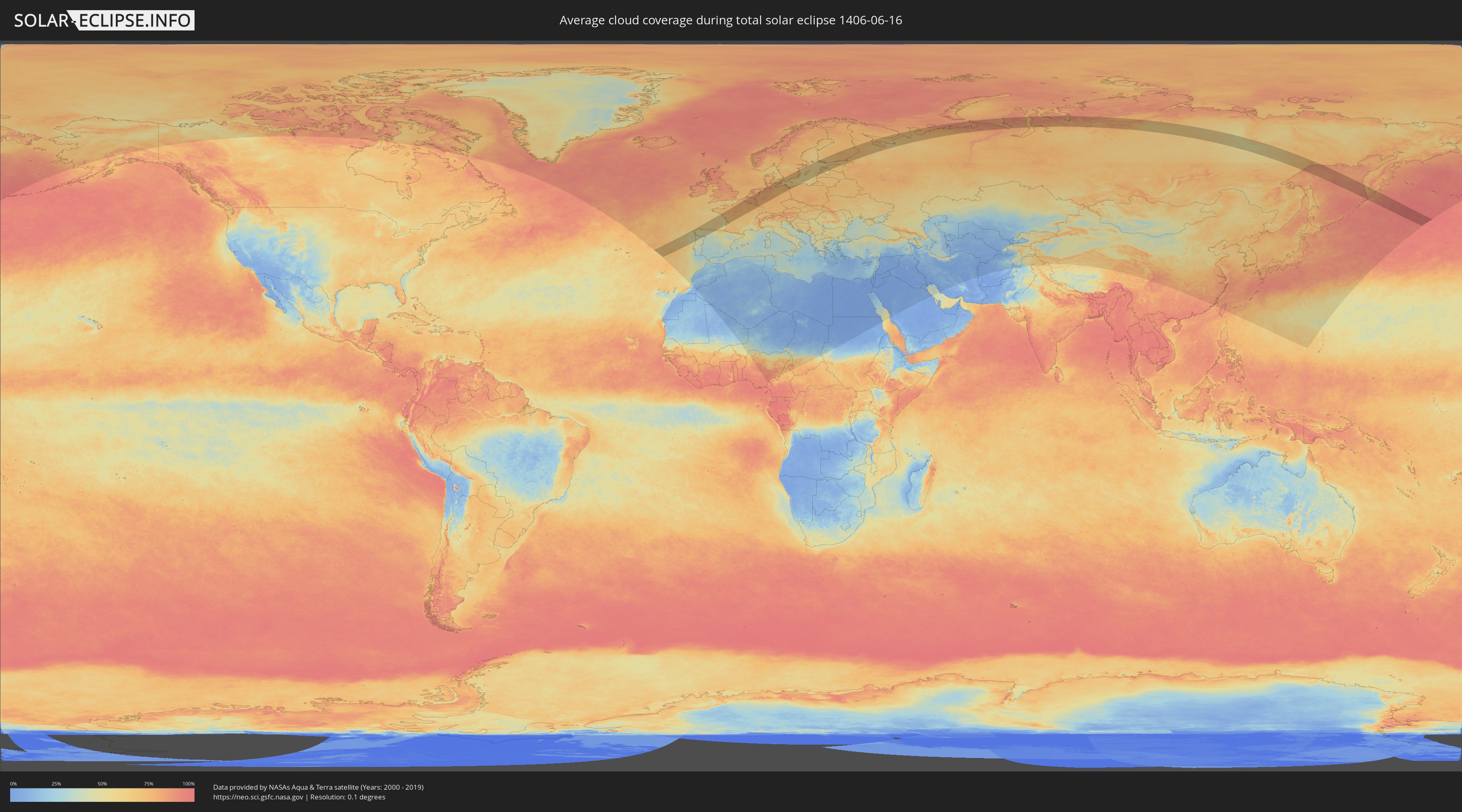
Wie wird das Wetter während der totalen Sonnenfinsternis am 16.06.1406?
Wo ist der beste Ort, um die totale Sonnenfinsternis vom 16.06.1406 zu beobachten?
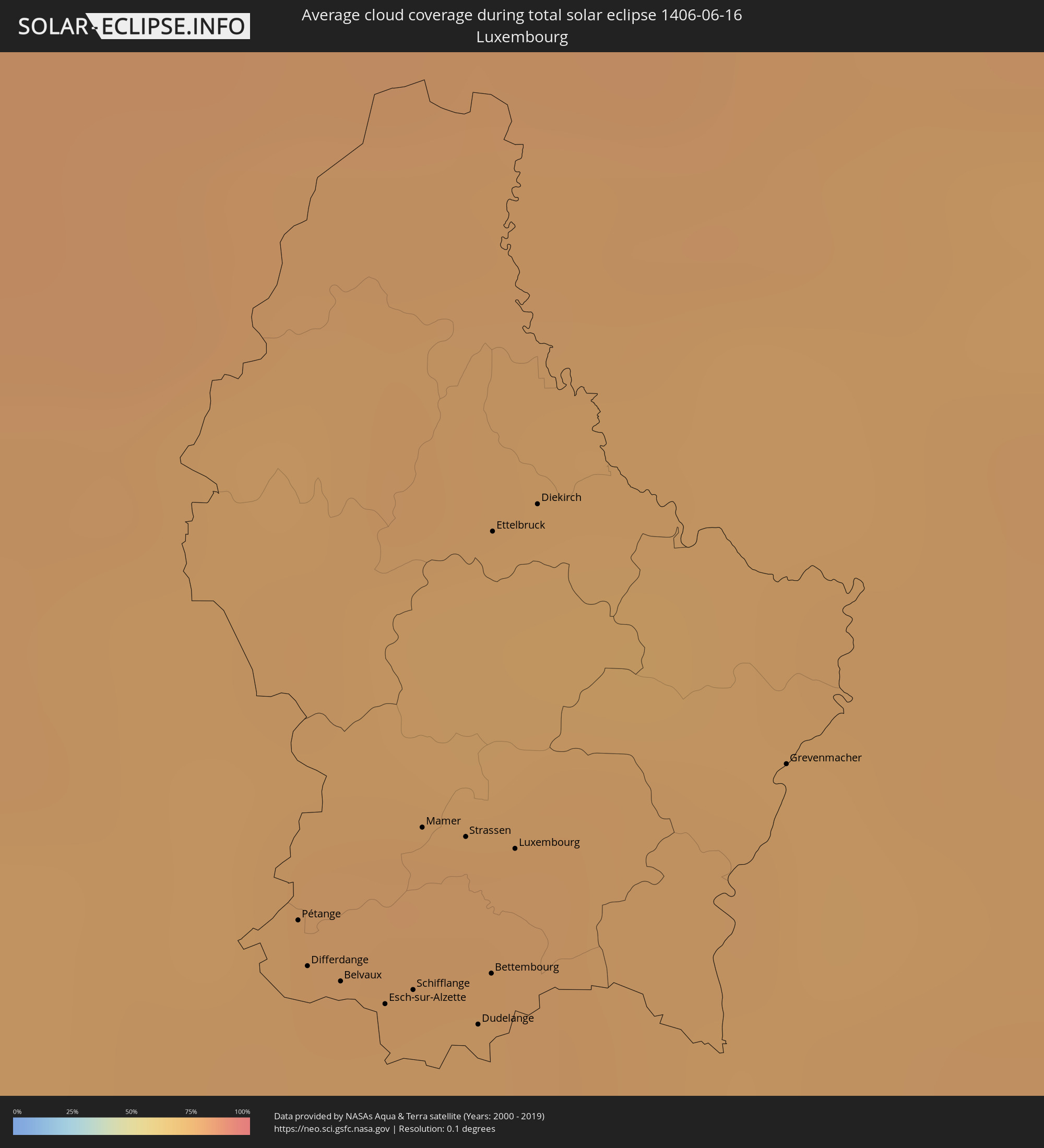
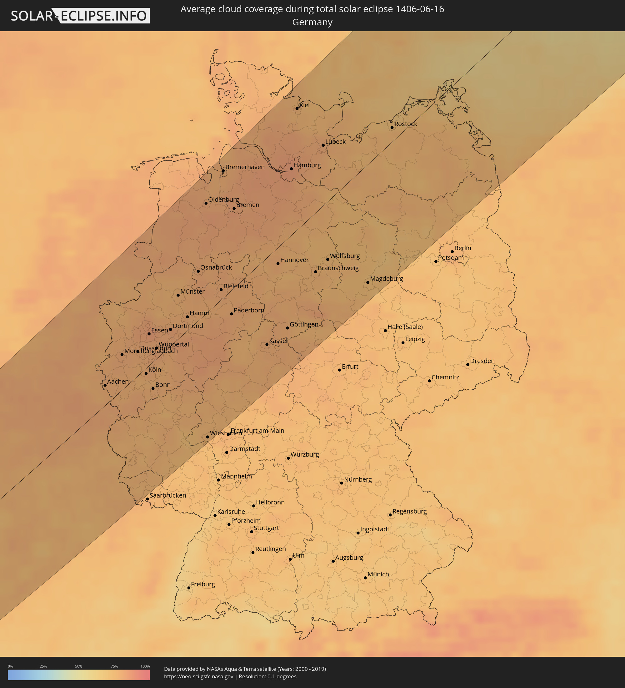
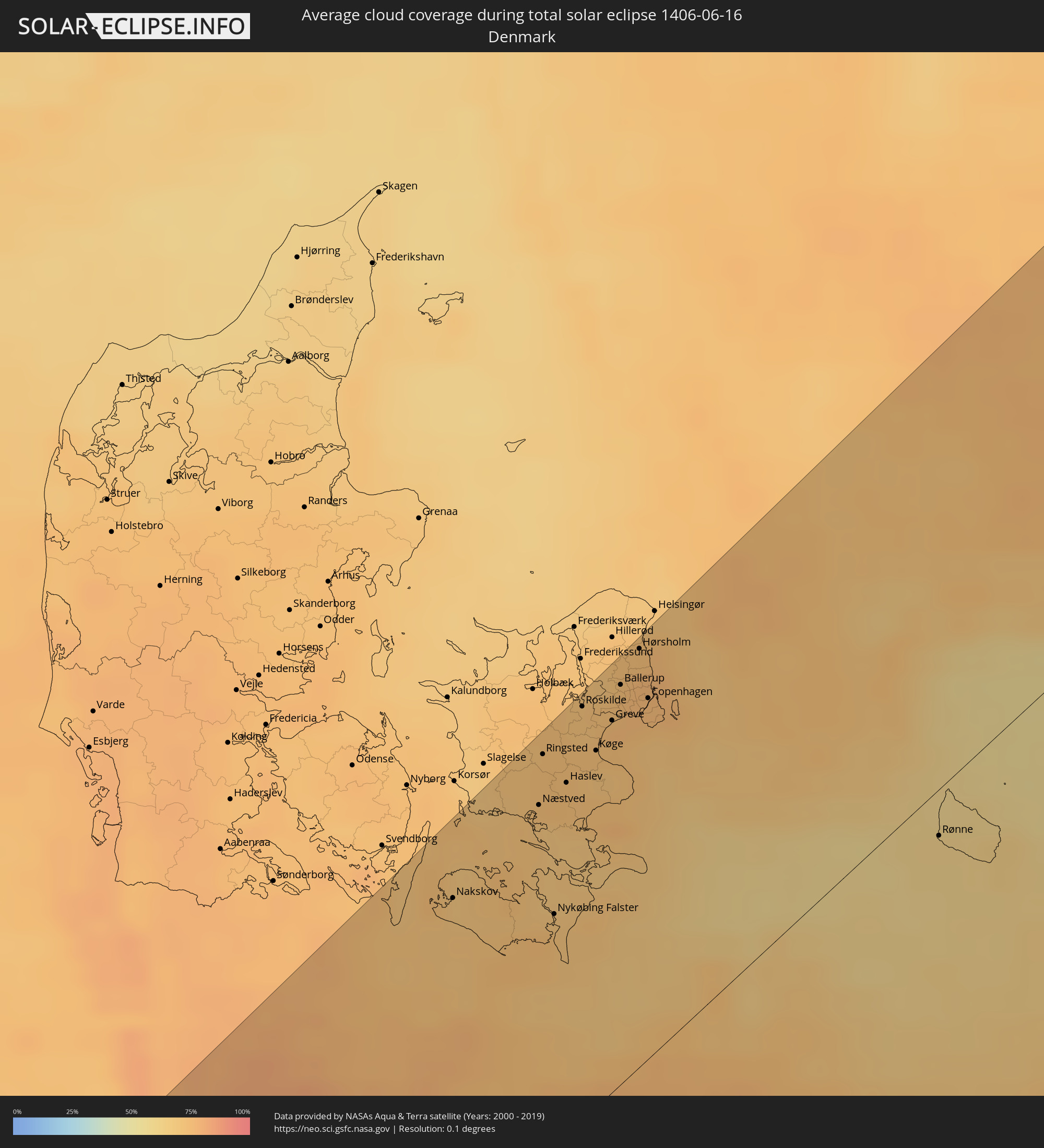
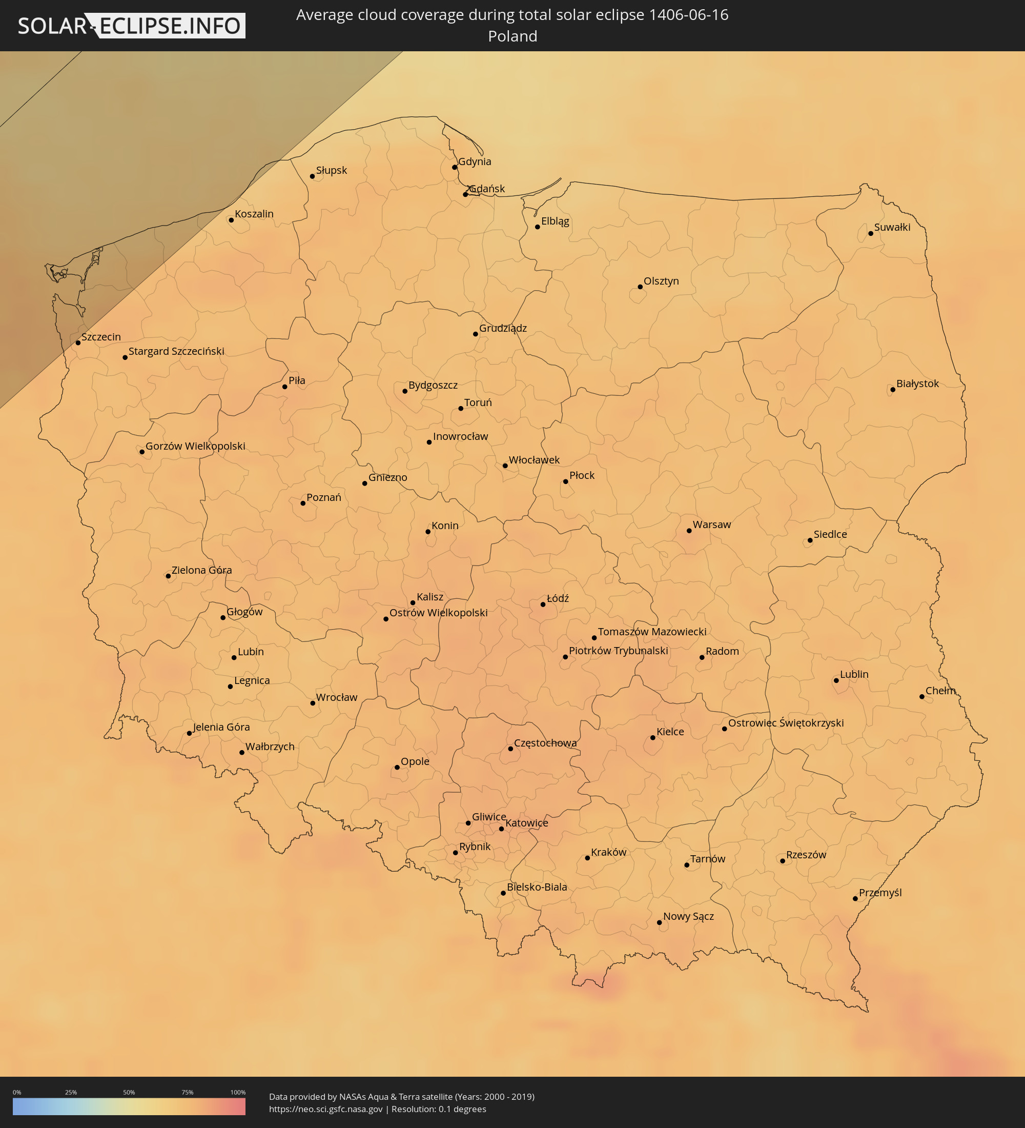
Die folgenden Karten zeigen die durchschnittliche Bewölkung für den Tag, an dem die totale Sonnenfinsternis
stattfindet. Mit Hilfe der Karten lässt sich der Ort entlang des Finsternispfades eingrenzen,
der die besten Aussichen auf einen klaren wolkenfreien Himmel bietet.
Trotzdem muss man immer lokale Gegenenheiten beachten und sollte sich genau über das Wetter an seinem
gewählten Beobachtungsort informieren.
Die Daten stammen von den beiden NASA-Satelliten
AQUA und TERRA
und wurden über einen Zeitraum von 19 Jahren (2000 - 2019) gemittelt.
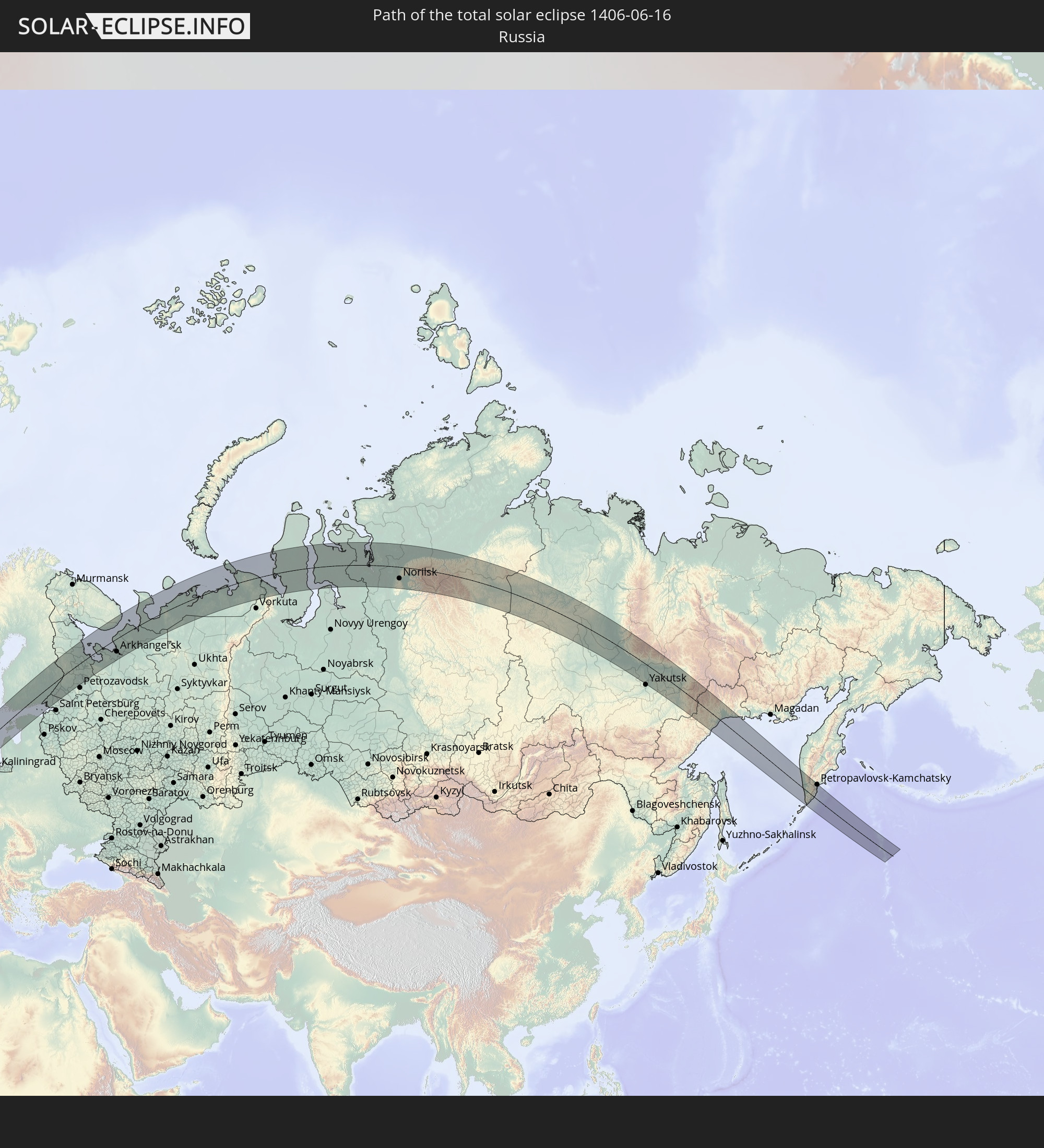
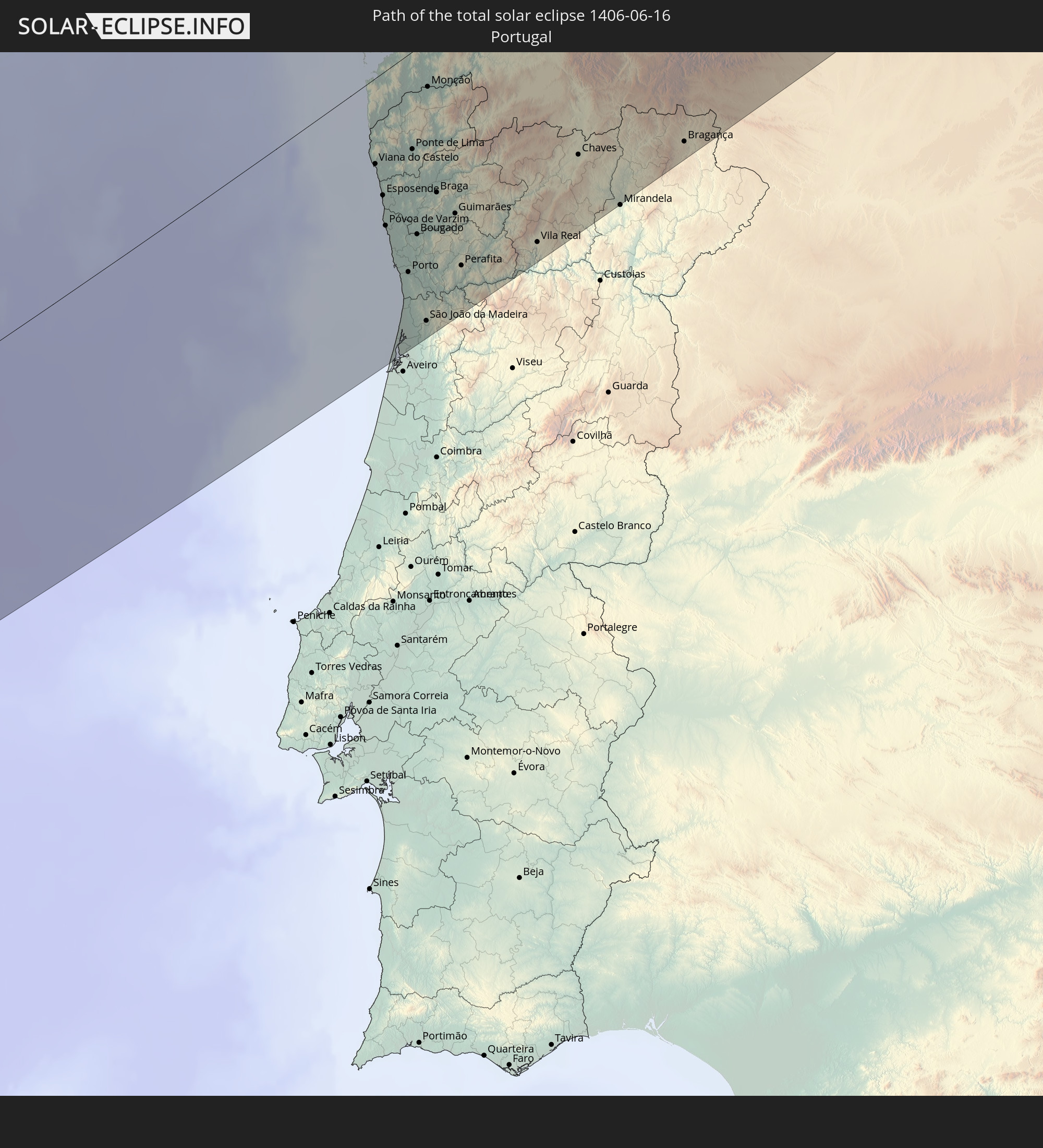
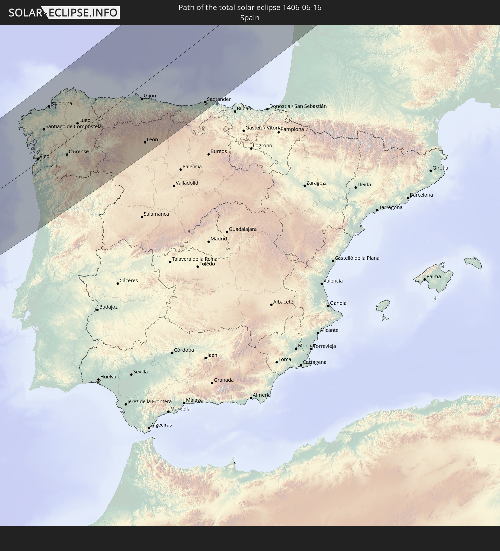
Detaillierte Länderkarten
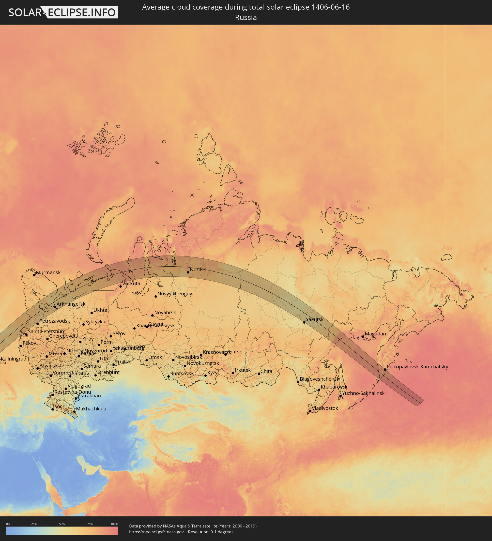 Russland
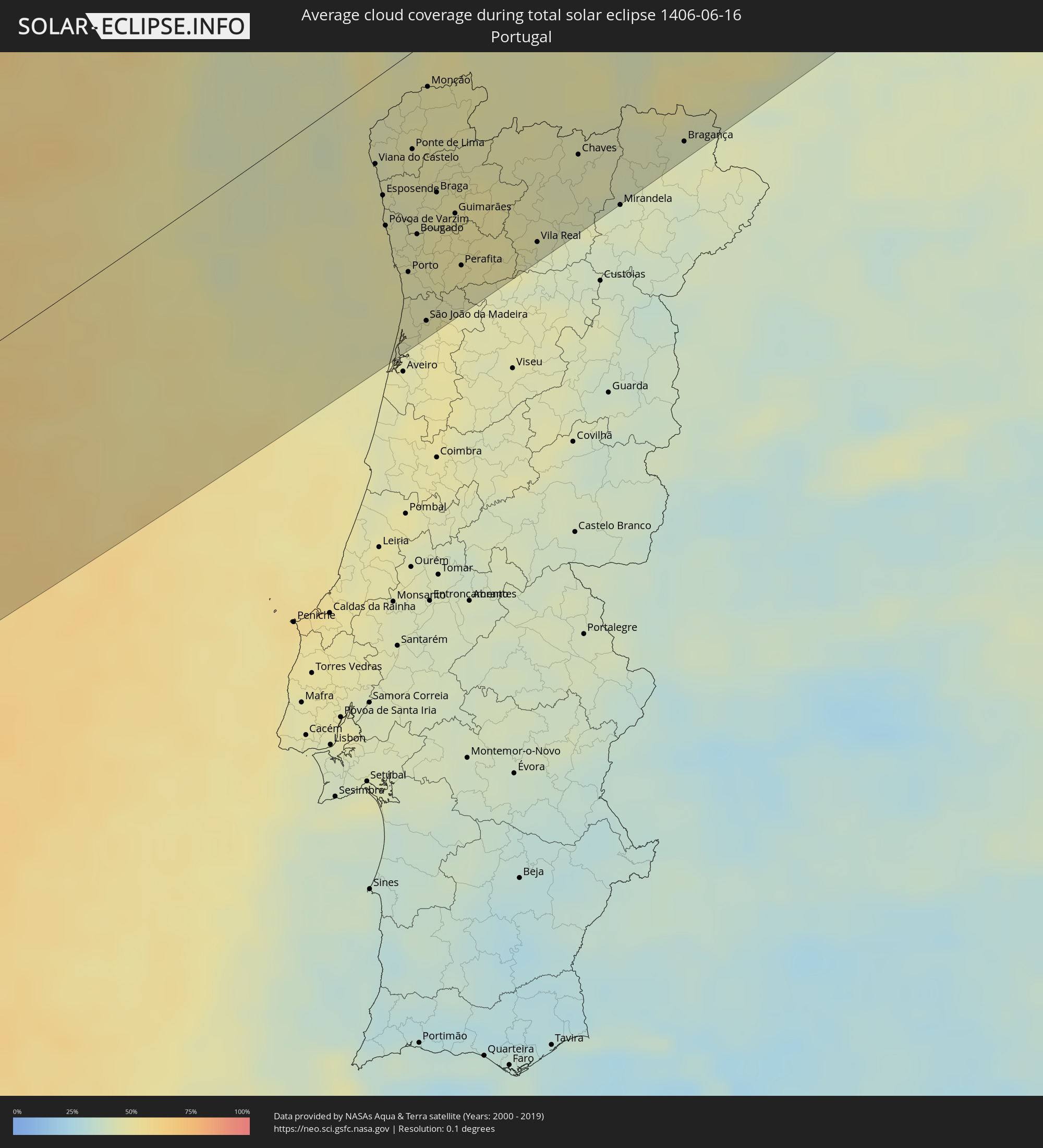 Portugal
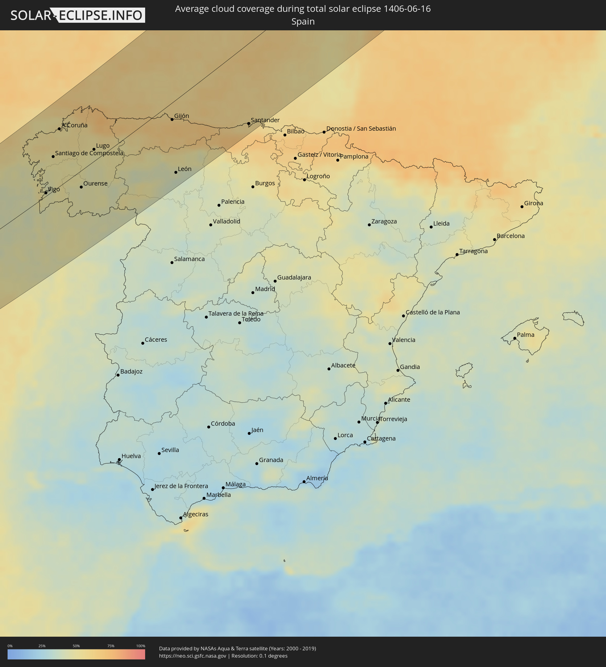 Spanien
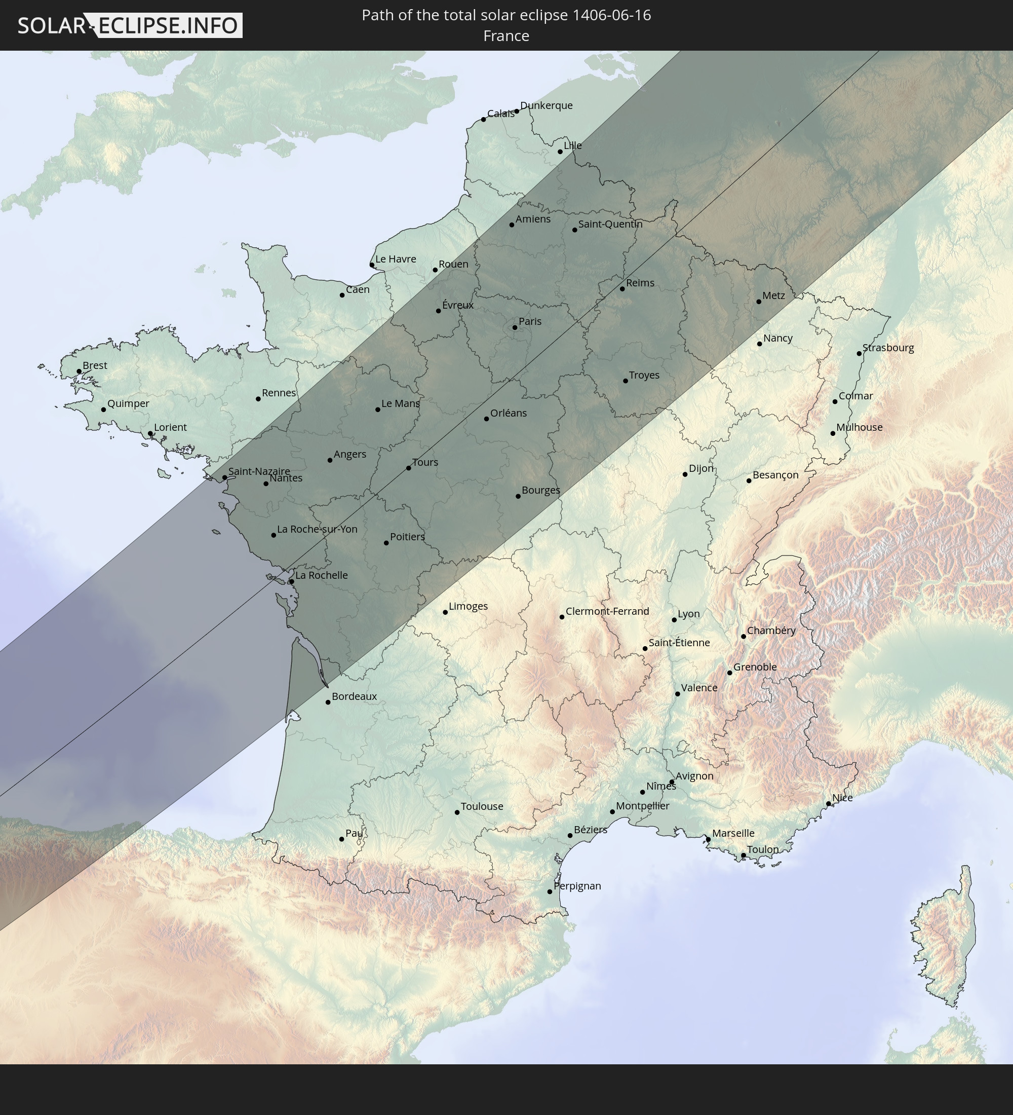
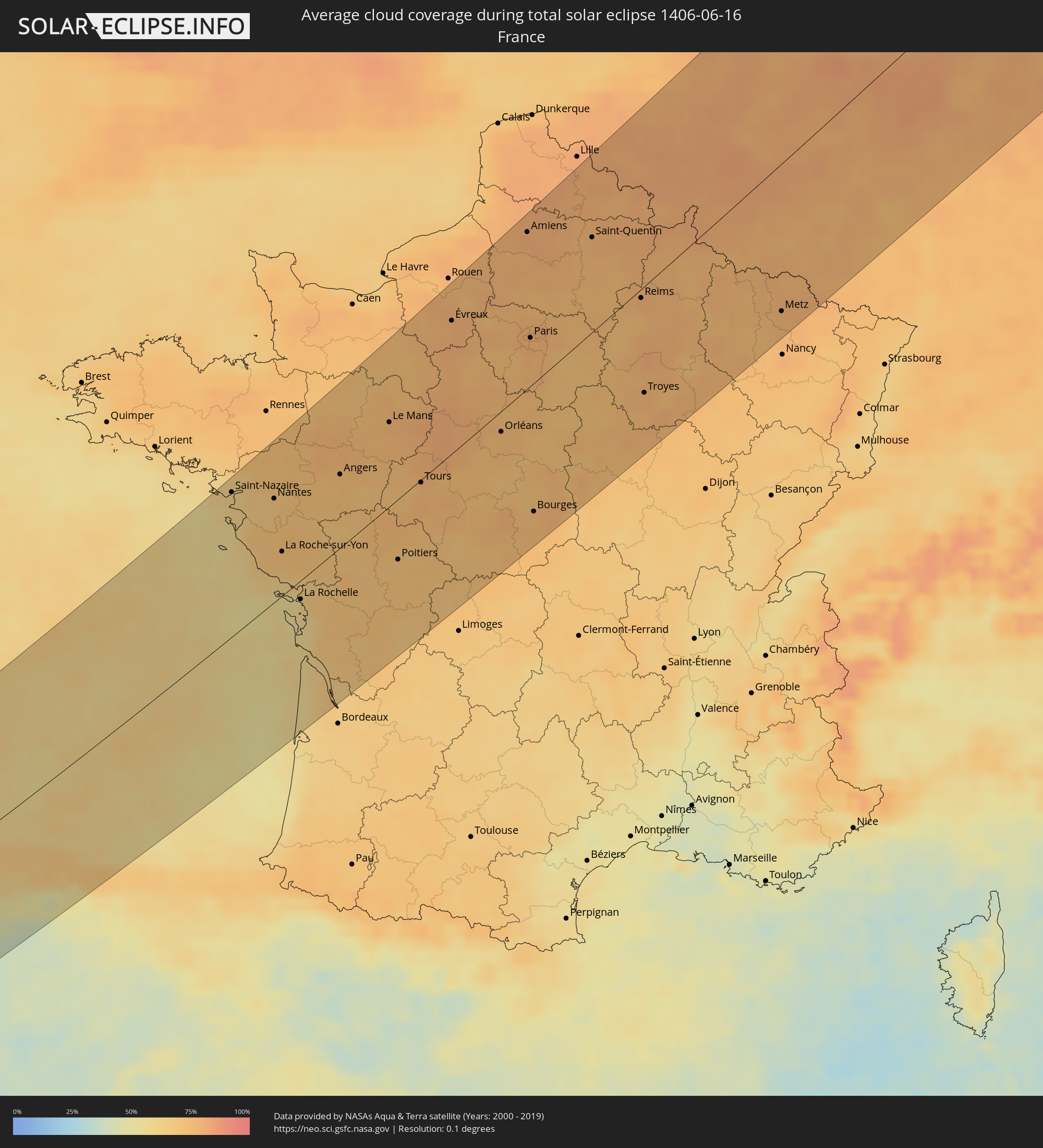 Frankreich
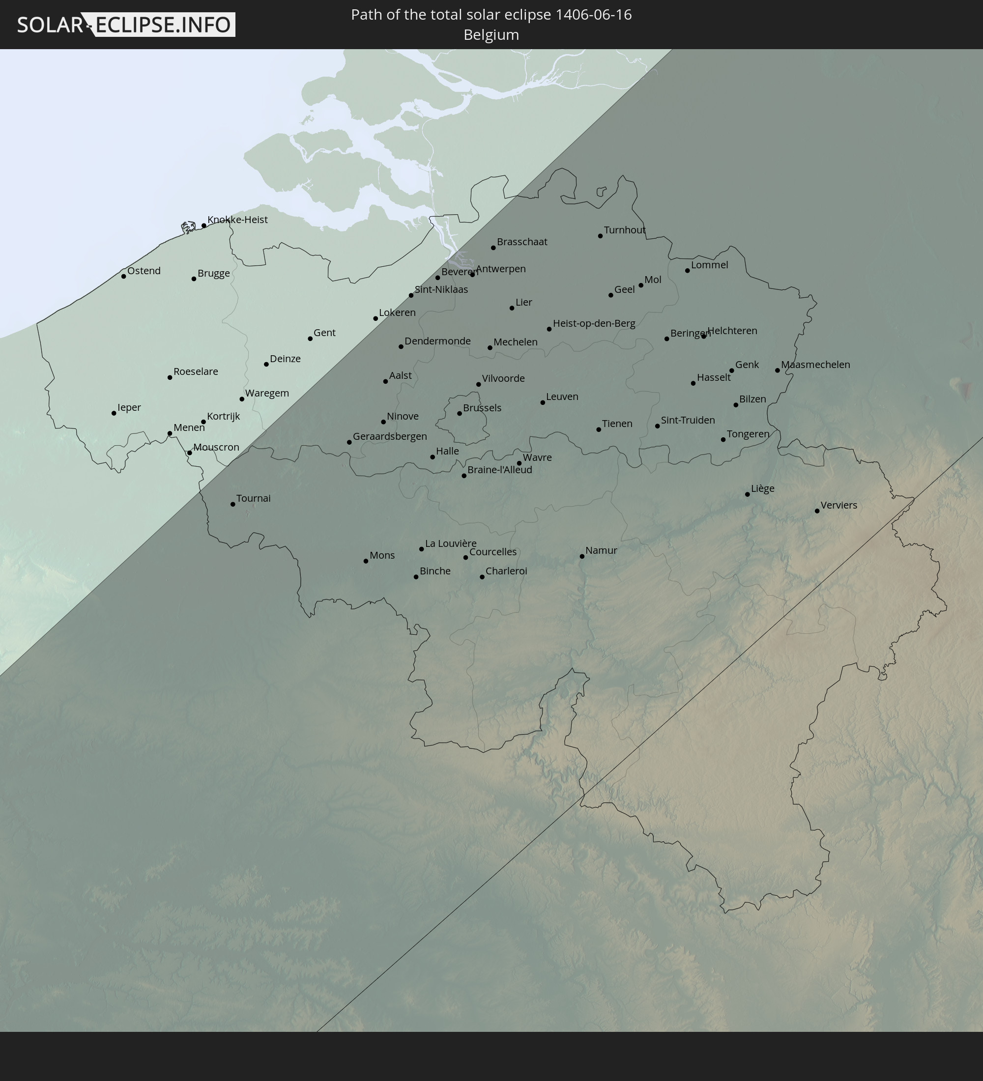
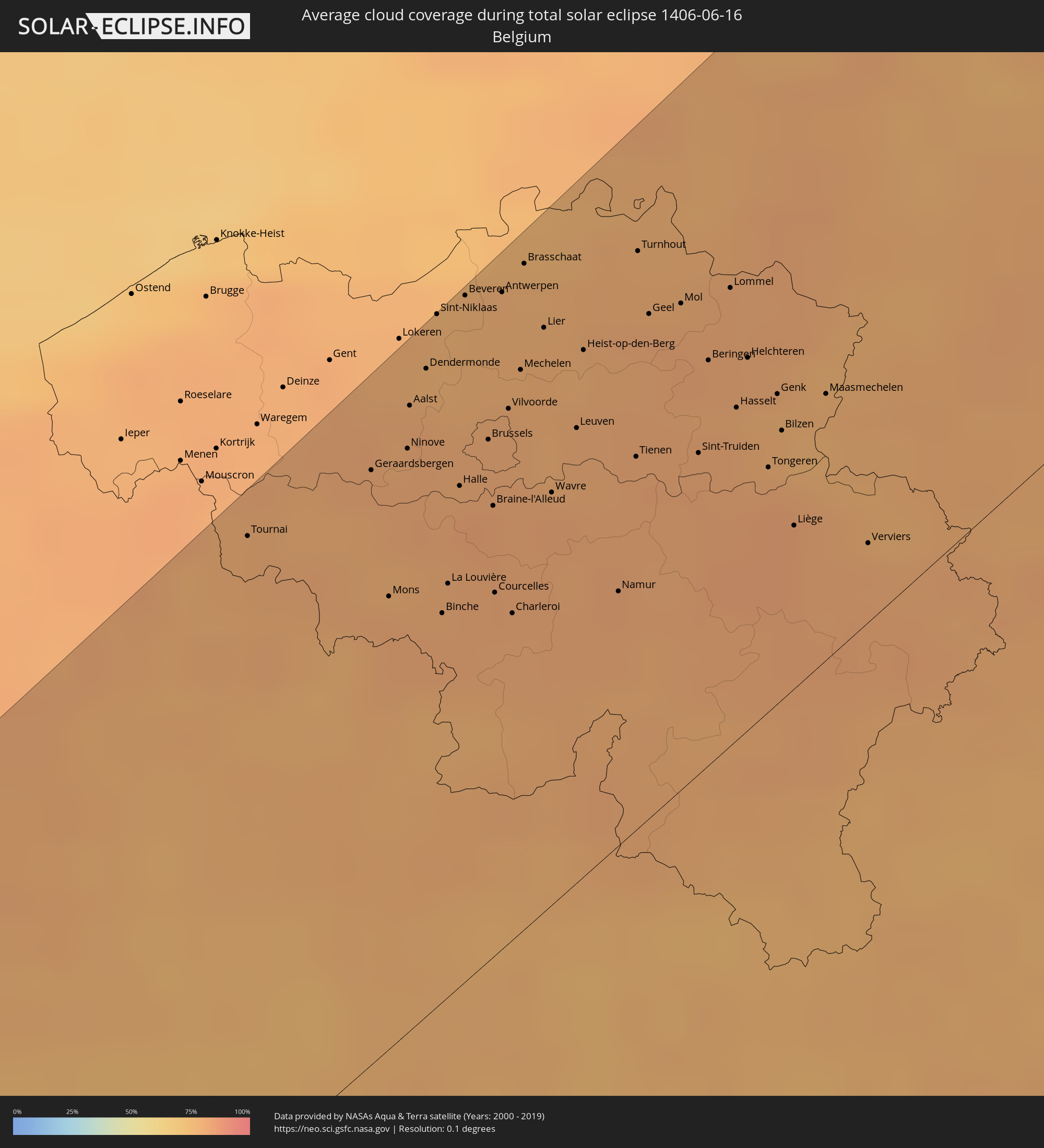 Belgien
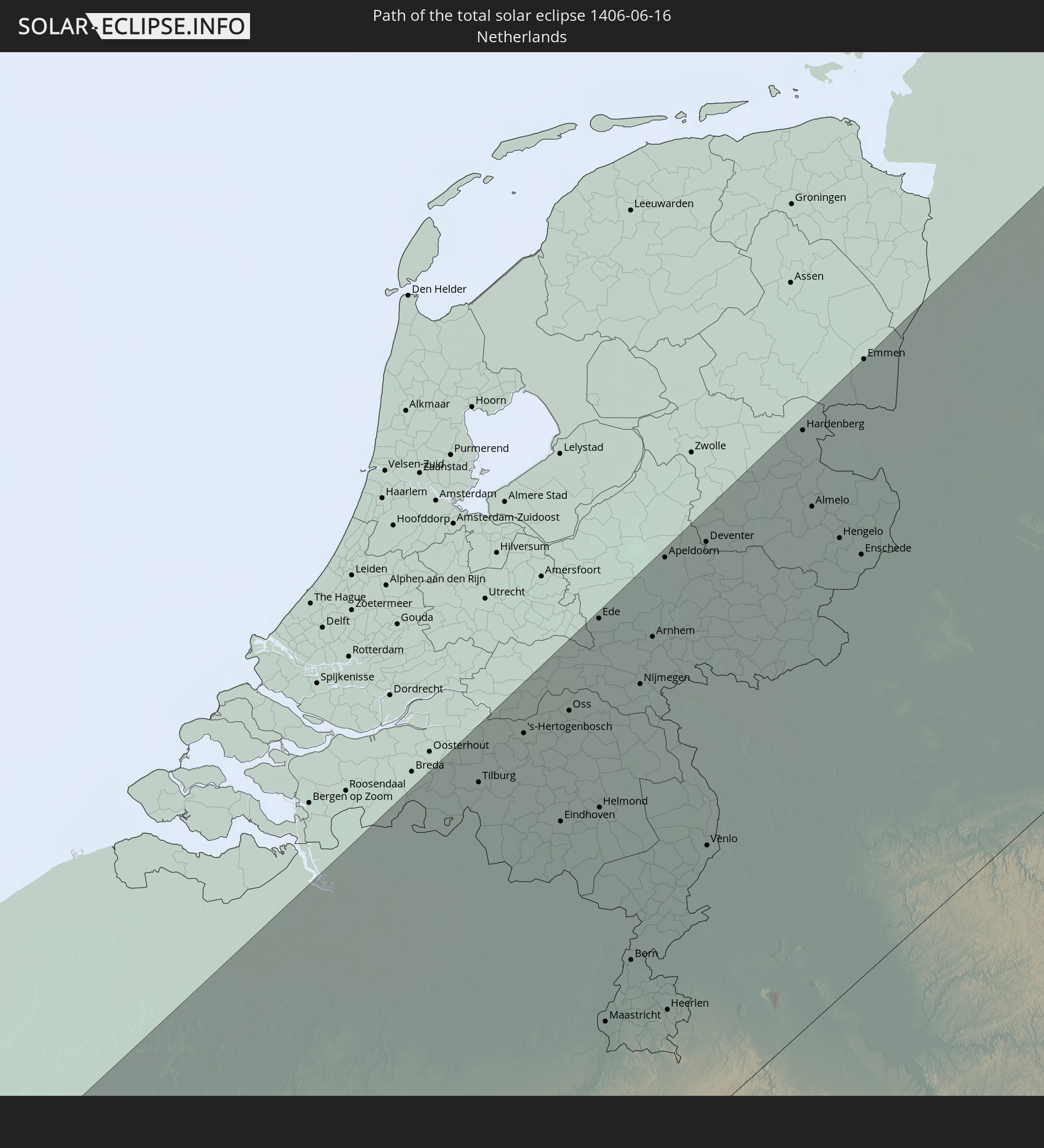
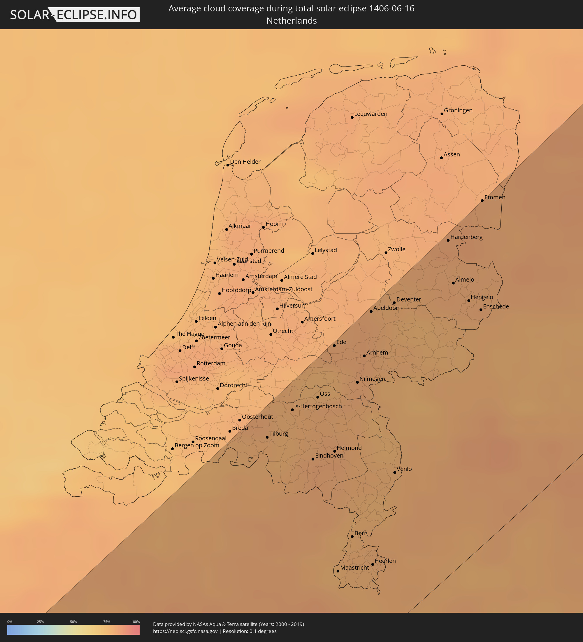 Niederlande
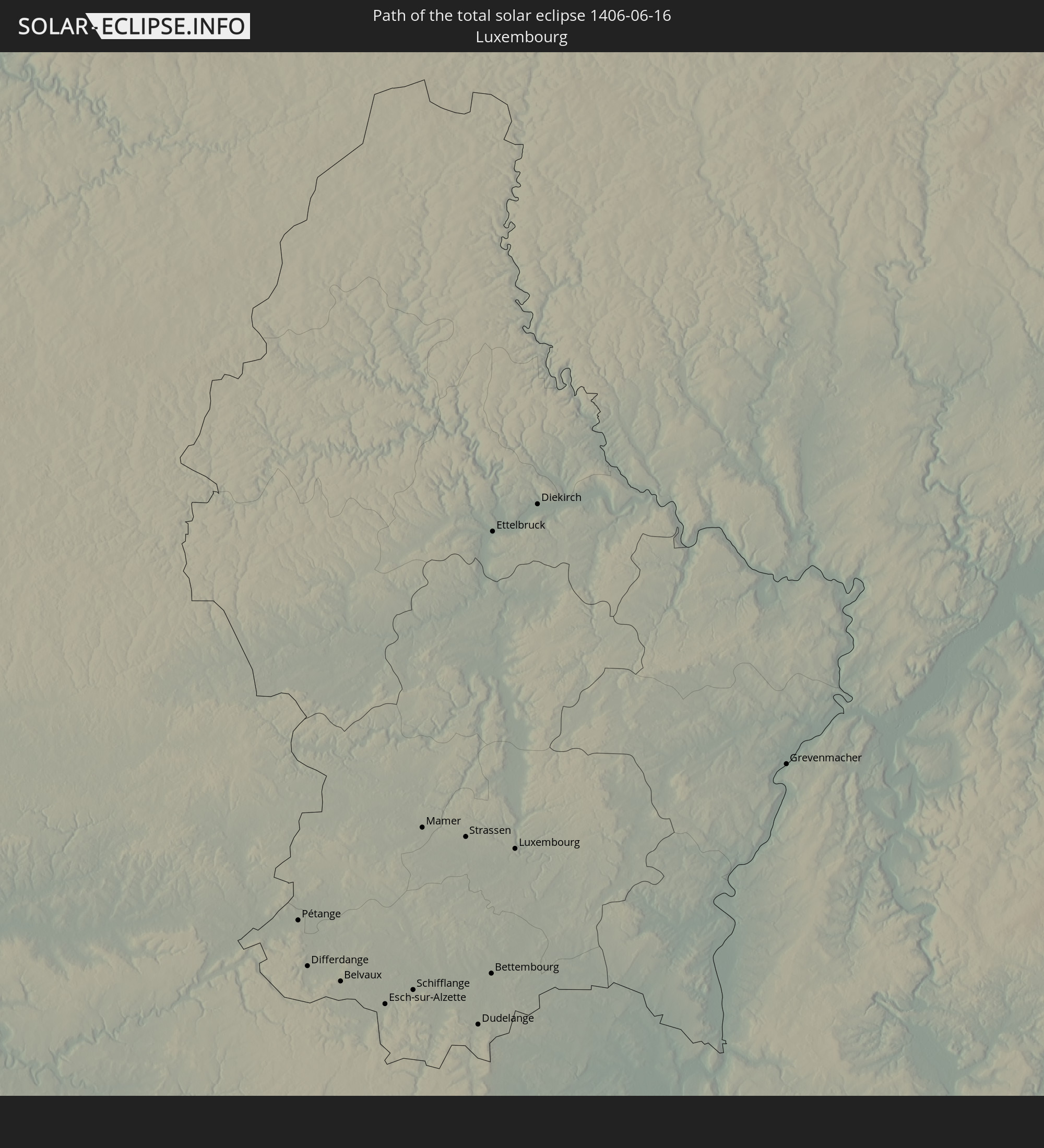
 Luxemburg
 Deutschland
 Dänemark
 Schweden
 Polen
Polen
 Åland Islands
 Finnland
 Lettland
 Estland
Orte im Finsternispfad
Die nachfolgene Tabelle zeigt Städte und Orte mit mehr als 5.000 Einwohnern, die sich im Finsternispfad befinden. Städte mit mehr als 100.000 Einwohnern sind dick gekennzeichnet. Mit einem Klick auf den Ort öffnet sich eine Detailkarte die die Lage des jeweiligen Ortes zusammen mit dem Verlauf der zentralen Finsternis präsentiert.
| Ort | Typ | Dauer der Verfinsterung | Ortszeit bei maximaler Verfinsterung | Entfernung zur Zentrallinie | Ø Bewölkung |
|
Viana do Castelo, Viana do Castelo
|
total | - | 05:18:54 UTC-00:36 | 40 km | 45% |
|
Esposende, Braga
|
total | - | 05:18:41 UTC-00:36 | 58 km | 49% |
|
Vilagarcía de Arousa, Galicia
|
total | - | 05:56:49 UTC+00:00 | 40 km | 47% |
|
Póvoa de Varzim, Porto
|
total | - | 05:18:29 UTC-00:36 | 75 km | 48% |
|
Vigo, Galicia
|
total | - | 05:56:19 UTC+00:00 | 5 km | 46% |
|
Pontevedra, Galicia
|
total | - | 05:56:33 UTC+00:00 | 19 km | 44% |
|
Porto, Porto
|
total | - | 05:18:08 UTC-00:36 | 101 km | 46% |
|
Ponte de Lima, Viana do Castelo
|
total | - | 05:18:55 UTC-00:36 | 45 km | 45% |
|
Bougado, Porto
|
total | - | 05:18:22 UTC-00:36 | 86 km | 46% |
|
Santiago de Compostela, Galicia
|
total | - | 05:57:07 UTC+00:00 | 55 km | 50% |
|
São João da Madeira, Aveiro
|
total | - | 05:17:47 UTC-00:36 | 128 km | 47% |
|
Monção, Viana do Castelo
|
total | - | 05:19:18 UTC-00:36 | 21 km | 47% |
|
Braga, Braga
|
total | - | 05:18:35 UTC-00:36 | 72 km | 48% |
|
A Coruña, Galicia
|
total | - | 05:57:44 UTC+00:00 | 94 km | 52% |
|
Moreira, Porto
|
total | - | 05:17:57 UTC-00:36 | 120 km | 44% |
|
Guimarães, Braga
|
total | - | 05:18:25 UTC-00:36 | 88 km | 49% |
|
Perafita, Porto
|
total | - | 05:18:04 UTC-00:36 | 113 km | 47% |
|
Ferrol, Galicia
|
total | - | 05:57:50 UTC+00:00 | 94 km | 52% |
|
Ourense, Galicia
|
total | - | 05:56:12 UTC+00:00 | 27 km | 45% |
|
Vila Real, Vila Real
|
total | - | 05:18:04 UTC-00:36 | 127 km | 41% |
|
Lugo, Galicia
|
total | - | 05:57:00 UTC+00:00 | 20 km | 47% |
|
Chaves, Vila Real
|
total | - | 05:18:33 UTC-00:36 | 100 km | 44% |
|
Bragança, Bragança
|
total | - | 05:18:26 UTC-00:36 | 130 km | 43% |
|
Ponferrada, Castille and León
|
total | - | 05:56:07 UTC+00:00 | 70 km | 46% |
|
Avilés, Asturias
|
total | - | 05:57:19 UTC+00:00 | 12 km | 63% |
|
Oviedo, Asturias
|
total | - | 05:57:02 UTC+00:00 | 33 km | 65% |
|
Gijón, Asturias
|
total | - | 05:57:14 UTC+00:00 | 27 km | 67% |
|
León, Castille and León
|
total | - | 05:55:56 UTC+00:00 | 115 km | 39% |
|
Torrelavega, Cantabria
|
total | - | 05:56:36 UTC+00:00 | 122 km | 68% |
|
Santander, Cantabria
|
total | - | 05:56:43 UTC+00:00 | 126 km | 57% |
|
Saint-Nazaire, Pays de la Loire
|
total | - | 06:11:17 UTC+00:09 | 130 km | 62% |
|
Nantes, Pays de la Loire
|
total | - | 06:11:06 UTC+00:09 | 95 km | 68% |
|
La Rochelle, Nouvelle-Aquitaine
|
total | - | 06:09:30 UTC+00:09 | 27 km | 58% |
|
Angers, Pays de la Loire
|
total | - | 06:11:22 UTC+00:09 | 65 km | 72% |
|
Le Mans, Pays de la Loire
|
total | - | 06:12:06 UTC+00:09 | 75 km | 76% |
|
Poitiers, Nouvelle-Aquitaine
|
total | - | 06:09:57 UTC+00:09 | 54 km | 70% |
|
Tours, Centre
|
total | - | 06:11:08 UTC+00:09 | 16 km | 75% |
|
Orléans, Centre
|
total | - | 06:11:51 UTC+00:09 | 30 km | 75% |
|
Saint-Quentin-en-Yvelines, Île-de-France
|
total | - | 06:13:11 UTC+00:09 | 50 km | 74% |
|
Cergy-Pontoise, Île-de-France
|
total | - | 06:13:36 UTC+00:09 | 72 km | 76% |
|
Amiens, Hauts-de-France
|
total | - | 06:14:57 UTC+00:09 | 130 km | 79% |
|
Paris, Île-de-France
|
total | - | 06:13:18 UTC+00:09 | 46 km | 77% |
|
Bourges, Centre
|
total | - | 06:10:34 UTC+00:09 | 112 km | 74% |
|
Tournai, Wallonia
|
total | - | 06:06:43 UTC+00:00 | 136 km | 79% |
|
Mons, Wallonia
|
total | - | 06:06:28 UTC+00:00 | 97 km | 80% |
|
Reims, Grand-Est
|
total | - | 06:13:54 UTC+00:09 | 8 km | 77% |
|
Aalst, Flanders
|
total | - | 06:07:15 UTC+00:00 | 132 km | 79% |
|
Sint-Niklaas, Flanders
|
total | - | 06:07:37 UTC+00:00 | 145 km | 78% |
|
La Louvière, Wallonia
|
total | - | 06:06:32 UTC+00:00 | 88 km | 79% |
|
Brussels, Brussels Capital
|
total | - | 06:07:07 UTC+00:00 | 110 km | 79% |
|
Antwerpen, Flanders
|
total | - | 06:07:43 UTC+00:00 | 138 km | 78% |
|
Charleroi, Wallonia
|
total | - | 06:06:25 UTC+00:00 | 70 km | 80% |
|
Mechelen, Flanders
|
total | - | 06:07:24 UTC+00:00 | 118 km | 79% |
|
Leuven, Flanders
|
total | - | 06:07:11 UTC+00:00 | 96 km | 80% |
|
Namur, Wallonia
|
total | - | 06:06:31 UTC+00:00 | 54 km | 81% |
|
Tilburg, North Brabant
|
total | - | 06:27:49 UTC+00:19 | 133 km | 78% |
|
Beringen, Flanders
|
total | - | 06:07:28 UTC+00:00 | 85 km | 79% |
|
's-Hertogenbosch, North Brabant
|
total | - | 06:28:04 UTC+00:19 | 134 km | 78% |
|
Hasselt, Flanders
|
total | - | 06:07:17 UTC+00:00 | 70 km | 80% |
|
Eindhoven, North Brabant
|
total | - | 06:27:39 UTC+00:19 | 105 km | 81% |
|
Oss, North Brabant
|
total | - | 06:28:11 UTC+00:19 | 131 km | 79% |
|
Liège, Wallonia
|
total | - | 06:06:49 UTC+00:00 | 34 km | 81% |
|
Ede, Gelderland
|
total | - | 06:28:38 UTC+00:19 | 144 km | 78% |
|
Maastricht, Limburg
|
total | - | 06:26:42 UTC+00:19 | 46 km | 78% |
|
Born, Limburg
|
total | - | 06:27:01 UTC+00:19 | 57 km | 79% |
|
Nijmegen, Gelderland
|
total | - | 06:28:20 UTC+00:19 | 120 km | 79% |
|
Verviers, Wallonia
|
total | - | 06:06:46 UTC+00:00 | 17 km | 80% |
|
Pétange, Luxembourg
|
total | - | 06:29:42 UTC+00:24 | 74 km | 77% |
|
Differdange, Luxembourg
|
total | - | 06:29:38 UTC+00:24 | 76 km | 77% |
|
Arnhem, Gelderland
|
total | - | 06:28:34 UTC+00:19 | 129 km | 81% |
|
Belvaux, Luxembourg
|
total | - | 06:29:37 UTC+00:24 | 79 km | 77% |
|
Apeldoorn, Gelderland
|
total | - | 06:28:57 UTC+00:19 | 144 km | 80% |
|
Esch-sur-Alzette, Luxembourg
|
total | - | 06:29:36 UTC+00:24 | 83 km | 77% |
|
Heerlen, Limburg
|
total | - | 06:26:47 UTC+00:19 | 39 km | 78% |
|
Schifflange, Luxembourg
|
total | - | 06:29:37 UTC+00:24 | 81 km | 77% |
|
Mamer, Luxembourg
|
total | - | 06:29:49 UTC+00:24 | 71 km | 77% |
|
Bertrange, Luxembourg
|
total | - | 06:29:47 UTC+00:24 | 74 km | 77% |
|
Strassen, Luxembourg
|
total | - | 06:29:48 UTC+00:24 | 74 km | 77% |
|
Aachen, North Rhine-Westphalia
|
total | - | 07:07:05 UTC+01:00 | 29 km | 79% |
|
Dudelange, Luxembourg
|
total | - | 06:29:35 UTC+00:24 | 86 km | 77% |
|
Bettembourg, Luxembourg
|
total | - | 06:29:39 UTC+00:24 | 84 km | 77% |
|
Ettelbruck, Diekirch
|
total | - | 06:30:10 UTC+00:24 | 56 km | 75% |
|
Luxembourg, Luxembourg
|
total | - | 06:29:48 UTC+00:24 | 77 km | 77% |
|
Diekirch, Diekirch
|
total | - | 06:30:12 UTC+00:24 | 57 km | 74% |
|
Venlo, Limburg
|
total | - | 06:27:35 UTC+00:19 | 69 km | 78% |
|
Metz, Grand-Est
|
total | - | 06:13:45 UTC+00:09 | 121 km | 76% |
|
Mönchengladbach, North Rhine-Westphalia
|
total | - | 07:07:46 UTC+01:00 | 42 km | 80% |
|
Grevenmacher, Grevenmacher
|
total | - | 07:05:19 UTC+01:00 | 87 km | 77% |
|
Hardenberg, Overijssel
|
total | - | 06:29:36 UTC+00:19 | 143 km | 82% |
|
Almelo, Overijssel
|
total | - | 06:29:15 UTC+00:19 | 124 km | 80% |
|
Duisburg, North Rhine-Westphalia
|
total | - | 07:08:12 UTC+01:00 | 47 km | 80% |
|
Düsseldorf, North Rhine-Westphalia
|
total | - | 07:07:51 UTC+01:00 | 26 km | 79% |
|
Enschede, Overijssel
|
total | - | 06:29:02 UTC+00:19 | 102 km | 78% |
|
Köln, North Rhine-Westphalia
|
total | - | 07:07:24 UTC+01:00 | 12 km | 76% |
|
Essen, North Rhine-Westphalia
|
total | - | 07:08:15 UTC+01:00 | 37 km | 83% |
|
Bonn, North Rhine-Westphalia
|
total | - | 07:07:05 UTC+01:00 | 35 km | 78% |
|
Wuppertal, North Rhine-Westphalia
|
total | - | 07:07:58 UTC+01:00 | 24 km | 81% |
|
Dortmund, North Rhine-Westphalia
|
total | - | 07:08:24 UTC+01:00 | 21 km | 81% |
|
Münster, North Rhine-Westphalia
|
total | - | 07:09:09 UTC+01:00 | 47 km | 78% |
|
Wiesbaden, Hesse
|
total | - | 07:06:07 UTC+01:00 | 138 km | 75% |
|
Bielefeld, North Rhine-Westphalia
|
total | - | 07:09:22 UTC+01:00 | 16 km | 80% |
|
Bremen, Bremen
|
total | - | 07:11:09 UTC+01:00 | 83 km | 84% |
|
Hannover, Lower Saxony
|
total | - | 07:10:06 UTC+01:00 | 18 km | 79% |
|
Hamburg, Hamburg
|
total | - | 07:12:10 UTC+01:00 | 70 km | 85% |
|
Nakskov, Zealand
|
total | - | 07:14:31 UTC+01:00 | 120 km | 70% |
|
Næstved, Zealand
|
total | - | 07:15:19 UTC+01:00 | 123 km | 69% |
|
Ringsted, Zealand
|
total | - | 07:15:41 UTC+01:00 | 140 km | 73% |
|
Nykøbing Falster, Zealand
|
total | - | 07:14:33 UTC+01:00 | 83 km | 70% |
|
Haslev, Zealand
|
total | - | 07:15:31 UTC+01:00 | 123 km | 72% |
|
Roskilde, Zealand
|
total | - | 07:16:05 UTC+01:00 | 142 km | 71% |
|
Køge, Zealand
|
total | - | 07:15:47 UTC+01:00 | 123 km | 73% |
|
Fløng, Capital Region
|
total | - | 07:16:09 UTC+01:00 | 140 km | 73% |
|
Greve, Zealand
|
total | - | 07:16:02 UTC+01:00 | 129 km | 76% |
|
Hørsholm, Capital Region
|
total | - | 07:16:35 UTC+01:00 | 143 km | 74% |
|
Kongens Lyngby, Capital Region
|
total | - | 07:16:24 UTC+01:00 | 134 km | 76% |
|
Copenhagen, Capital Region
|
total | - | 07:16:15 UTC+01:00 | 124 km | 75% |
|
Christianshavn, Capital Region
|
total | - | 07:16:15 UTC+01:00 | 122 km | 75% |
|
Dragør, Capital Region
|
total | - | 07:16:08 UTC+01:00 | 113 km | 73% |
|
Landskrona, Skåne
|
total | - | 07:16:39 UTC+01:00 | 129 km | 71% |
|
Malmö, Skåne
|
total | - | 07:16:14 UTC+01:00 | 99 km | 69% |
|
Trelleborg, Skåne
|
total | - | 07:15:52 UTC+01:00 | 74 km | 69% |
|
Lund, Skåne
|
total | - | 07:16:27 UTC+01:00 | 101 km | 71% |
|
Eslöv, Skåne
|
total | - | 07:16:42 UTC+01:00 | 105 km | 72% |
|
Hässleholm, Skåne
|
total | - | 07:17:22 UTC+01:00 | 110 km | 73% |
|
Ystad, Skåne
|
total | - | 07:16:07 UTC+01:00 | 51 km | 69% |
|
Kristianstad, Skåne
|
total | - | 07:17:15 UTC+01:00 | 84 km | 67% |
|
Świnoujście, West Pomeranian Voivodeship
|
total | - | 07:37:37 UTC+01:24 | 96 km | 73% |
|
Międzyzdroje, West Pomeranian Voivodeship
|
total | - | 07:37:42 UTC+01:24 | 102 km | 72% |
|
Police, West Pomeranian Voivodeship
|
total | - | 07:37:05 UTC+01:24 | 139 km | 75% |
|
Wolin, West Pomeranian Voivodeship
|
total | - | 07:37:36 UTC+01:24 | 116 km | 70% |
|
Rønne, Capital Region
|
total | - | 07:15:47 UTC+01:00 | 16 km | 62% |
|
Kamień Pomorski, West Pomeranian Voivodeship
|
total | - | 07:37:51 UTC+01:24 | 113 km | 69% |
|
Växjö, Kronoberg
|
total | - | 07:18:53 UTC+01:00 | 124 km | 74% |
|
Karlshamn, Blekinge
|
total | - | 07:17:41 UTC+01:00 | 65 km | 72% |
|
Gryfice, West Pomeranian Voivodeship
|
total | - | 07:37:53 UTC+01:24 | 136 km | 74% |
|
Trzebiatów, West Pomeranian Voivodeship
|
total | - | 07:38:09 UTC+01:24 | 126 km | 69% |
|
Kołobrzeg, West Pomeranian Voivodeship
|
total | - | 07:38:26 UTC+01:24 | 132 km | 69% |
|
Karlskrona, Blekinge
|
total | - | 07:17:52 UTC+01:00 | 33 km | 69% |
|
Kalmar, Kalmar
|
total | - | 07:18:58 UTC+01:00 | 44 km | 71% |
|
Oskarshamn, Kalmar
|
total | - | 07:20:02 UTC+01:00 | 87 km | 74% |
|
Västervik, Kalmar
|
total | - | 07:20:57 UTC+01:00 | 119 km | 73% |
|
Visby, Gotland
|
total | - | 07:21:18 UTC+01:00 | 46 km | 59% |
|
Pāvilosta, Pāvilostas
|
total | - | 07:57:38 UTC+01:36 | 137 km | 62% |
|
Alsunga, Alsunga
|
total | - | 07:57:57 UTC+01:36 | 143 km | 65% |
|
Ventspils, Ventspils
|
total | - | 07:58:40 UTC+01:36 | 110 km | 62% |
|
Turku, Southwest Finland
|
total | - | 08:07:31 UTC+01:39 | 120 km | 64% |
|
Dundaga, Dundaga
|
total | - | 07:59:12 UTC+01:36 | 130 km | 68% |
|
Kuressaare, Saare
|
total | - | 08:02:59 UTC+01:39 | 75 km | 72% |
|
Kärdla, Hiiumaa
|
total | - | 08:04:23 UTC+01:39 | 20 km | 60% |
|
Haapsalu, Lääne
|
total | - | 08:04:38 UTC+01:39 | 54 km | 62% |
|
Keila, Harjumaa
|
total | - | 08:05:39 UTC+01:39 | 58 km | 62% |
|
Hämeenlinna, Häme
|
total | - | 08:09:24 UTC+01:39 | 85 km | 67% |
|
Pärnu, Pärnumaa
|
total | - | 08:04:07 UTC+01:39 | 137 km | 65% |
|
Saue, Harjumaa
|
total | - | 08:05:45 UTC+01:39 | 60 km | 63% |
|
Espoo, Uusimaa
|
total | - | 08:08:08 UTC+01:39 | 19 km | 69% |
|
Tallinn, Harjumaa
|
total | - | 08:06:03 UTC+01:39 | 57 km | 61% |
|
Rapla, Raplamaa
|
total | - | 08:05:20 UTC+01:39 | 96 km | 68% |
|
Nurmijärvi, Uusimaa
|
total | - | 08:08:39 UTC+01:39 | 30 km | 66% |
|
Hyvinge, Uusimaa
|
total | - | 08:08:58 UTC+01:39 | 42 km | 67% |
|
Helsinki, Uusimaa
|
total | - | 08:08:12 UTC+01:39 | 6 km | 73% |
|
Maardu, Harjumaa
|
total | - | 08:06:15 UTC+01:39 | 65 km | 59% |
|
Vantaa, Uusimaa
|
total | - | 08:08:28 UTC+01:39 | 9 km | 67% |
|
Järvenpää, Uusimaa
|
total | - | 08:08:48 UTC+01:39 | 23 km | 68% |
|
Türi, Järvamaa
|
total | - | 08:05:18 UTC+01:39 | 136 km | 70% |
|
Paide, Järvamaa
|
total | - | 08:05:29 UTC+01:39 | 134 km | 70% |
|
Lahti, Päijänne Tavastia
|
total | - | 08:09:56 UTC+01:39 | 43 km | 70% |
|
Porvoo, Uusimaa
|
total | - | 08:08:56 UTC+01:39 | 10 km | 67% |
|
Tapa, Lääne-Virumaa
|
total | - | 08:06:19 UTC+01:39 | 116 km | 69% |
|
Rakvere, Lääne-Virumaa
|
total | - | 08:06:40 UTC+01:39 | 123 km | 70% |
|
Kotka, Kymenlaakso
|
total | - | 08:09:40 UTC+01:39 | 47 km | 76% |
|
Mikkeli, Southern Savonia
|
total | - | 08:11:55 UTC+01:39 | 48 km | 73% |
|
Kuopio, Northern Savo
|
total | - | 08:14:08 UTC+01:39 | 136 km | 74% |
|
Lappeenranta, South Karelia
|
total | - | 08:11:20 UTC+01:39 | 42 km | 74% |
|
Vyborg, Leningradskaya Oblast'
|
total | - | 09:01:30 UTC+02:30 | 90 km | 70% |
|
Joensuu, North Karelia
|
total | - | 08:14:43 UTC+01:39 | 46 km | 69% |
|
Sortavala, Republic of Karelia
|
total | - | 09:04:15 UTC+02:30 | 65 km | 71% |
|
Kondopoga, Republic of Karelia
|
total | - | 09:07:09 UTC+02:30 | 132 km | 68% |
|
Segezha, Republic of Karelia
|
total | - | 09:09:35 UTC+02:30 | 9 km | 67% |
|
Onega, Arkhangelskaya
|
total | - | 09:12:13 UTC+02:30 | 85 km | 61% |
|
Severodvinsk, Arkhangelskaya
|
total | - | 09:14:18 UTC+02:30 | 68 km | 61% |
|
Arkhangel’sk, Arkhangelskaya
|
total | - | 09:14:45 UTC+02:30 | 88 km | 61% |
|
Novodvinsk, Arkhangelskaya
|
total | - | 09:14:45 UTC+02:30 | 106 km | 62% |
|
Dudinka, Krasnoyarskiy
|
total | - | 13:34:45 UTC+06:11 | 76 km | 76% |
|
Kayyerkan, Krasnoyarskiy
|
total | - | 13:35:54 UTC+06:11 | 74 km | 78% |
|
Norilsk, Krasnoyarskiy
|
total | - | 13:36:15 UTC+06:11 | 75 km | 76% |
|
Talnakh, Krasnoyarskiy
|
total | - | 13:36:19 UTC+06:11 | 59 km | 79% |
|
Yelizovo, Kamtsjatka
|
total | - | 18:48:49 UTC+10:34 | 134 km | 70% |
|
Vilyuchinsk, Kamtsjatka
|
total | - | 18:49:10 UTC+10:34 | 113 km | 79% |
|
Petropavlovsk-Kamchatsky, Kamtsjatka
|
total | - | 18:48:57 UTC+10:34 | 133 km | 73% |