Totale Sonnenfinsternis vom 11.08.1542
| Wochentag: | Dienstag |
| Maximale Dauer der Verfinsterung: | 04m12s |
| Maximale Breite des Finsternispfades: | 184 km |
| Saroszyklus: | 118 |
| Bedeckungsgrad: | 100% |
| Magnitude: | 1.0525 |
| Gamma: | 0.3454 |
Wo kann man die Sonnenfinsternis vom 11.08.1542 sehen?
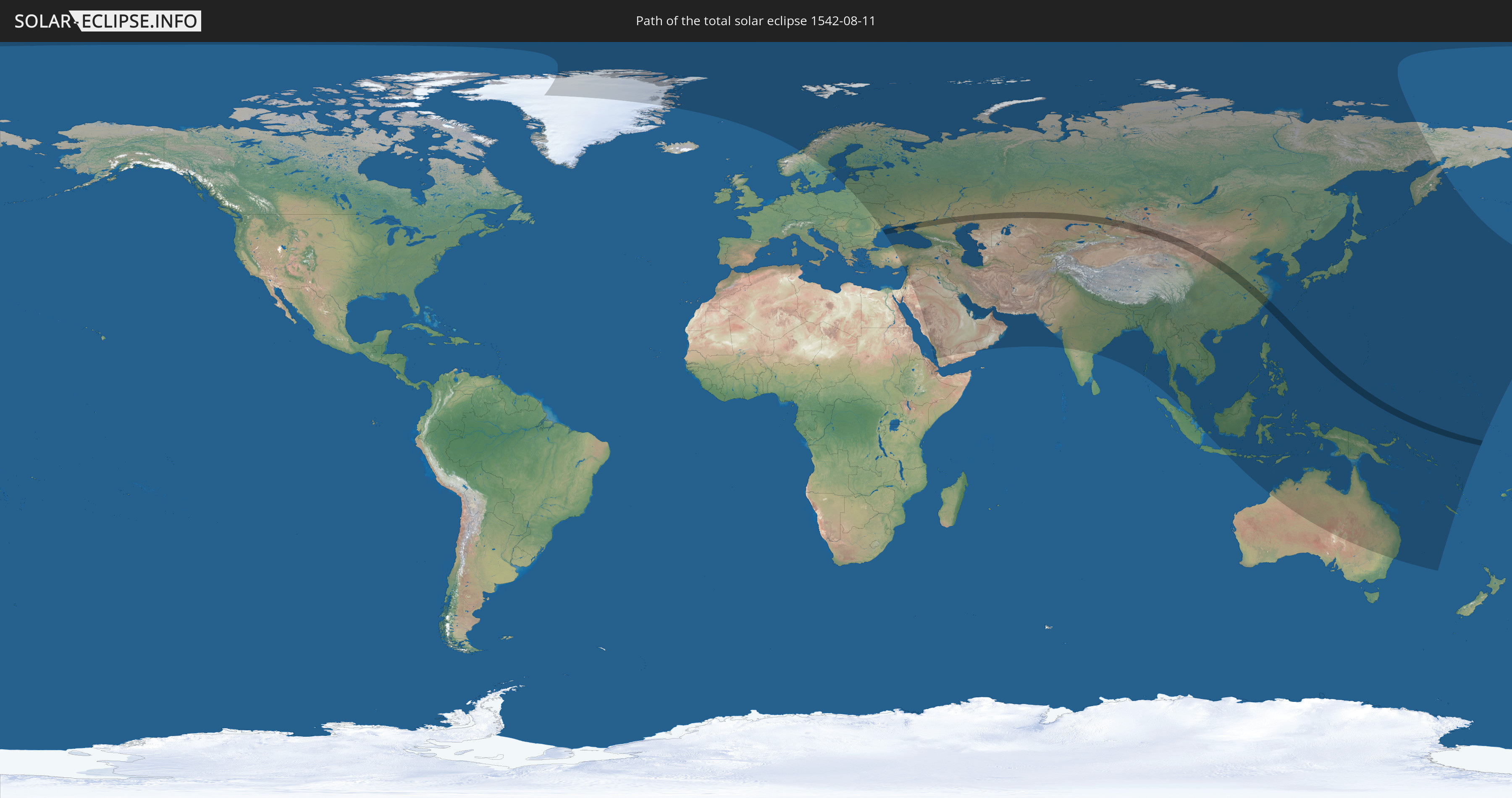
Die Sonnenfinsternis am 11.08.1542 kann man in 73 Ländern als partielle Sonnenfinsternis beobachten.
Der Finsternispfad verläuft durch 7 Länder. Nur in diesen Ländern ist sie als totale Sonnenfinsternis zu sehen.
In den folgenden Ländern ist die Sonnenfinsternis total zu sehen
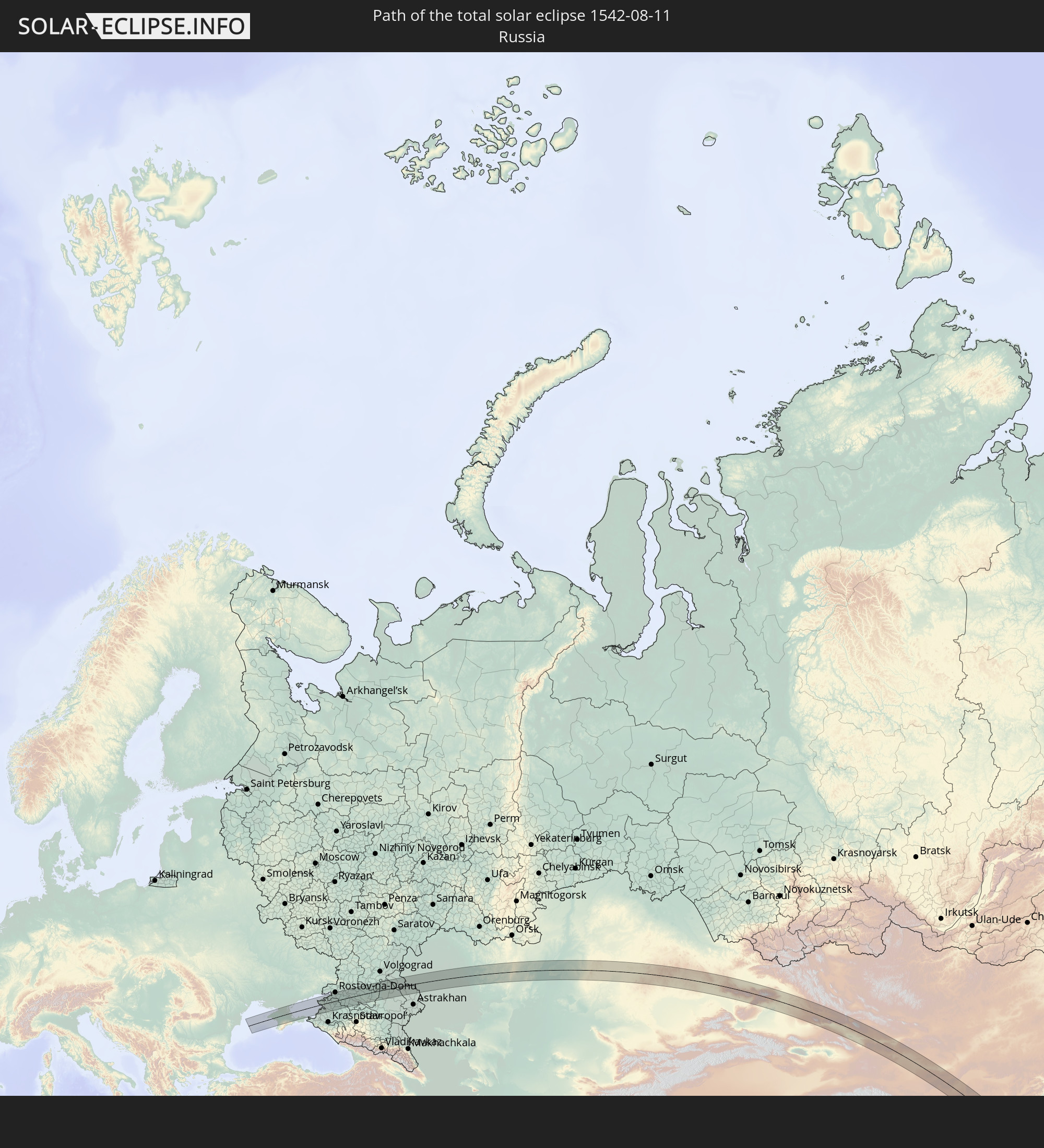 Russland
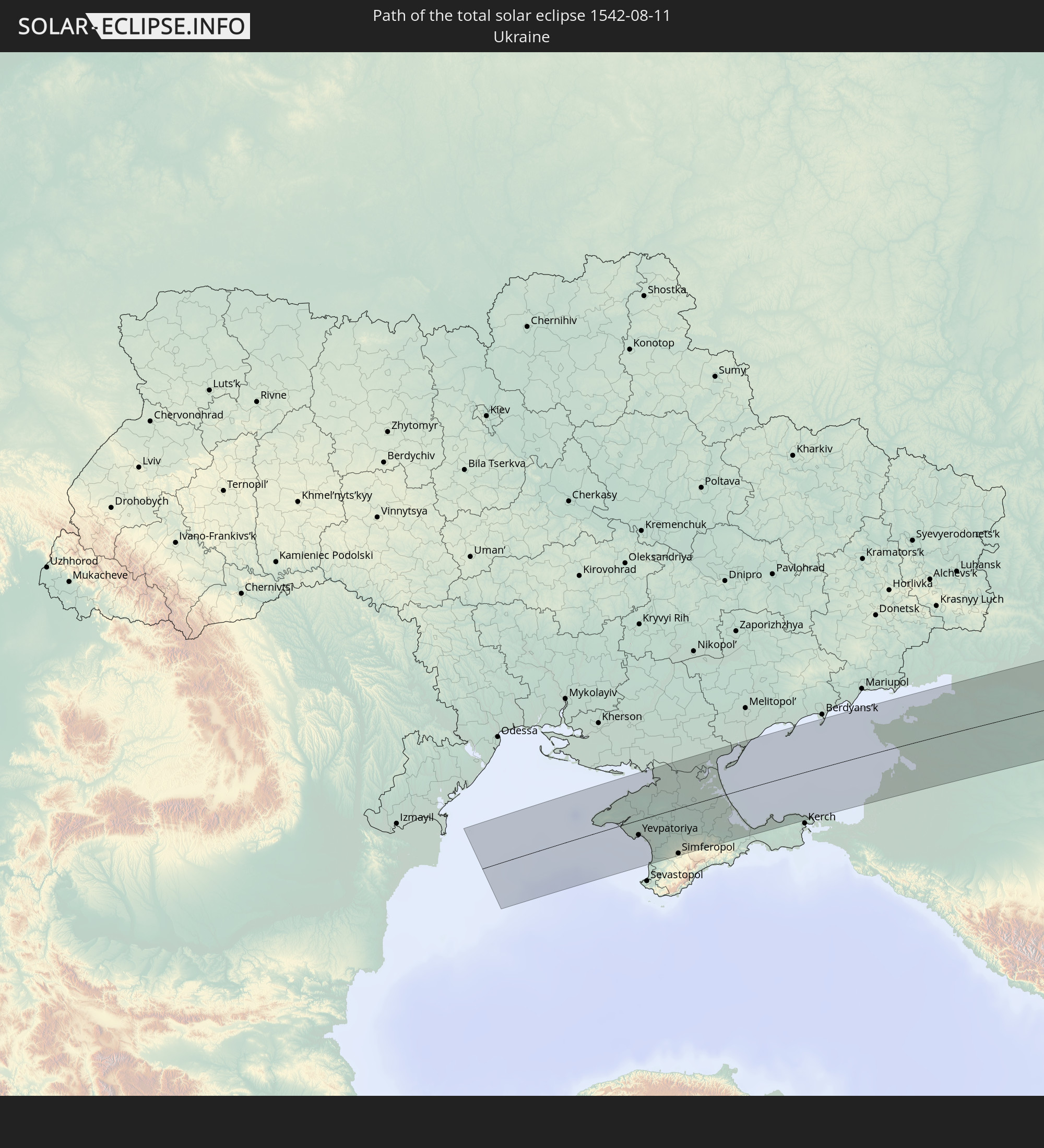 Ukraine
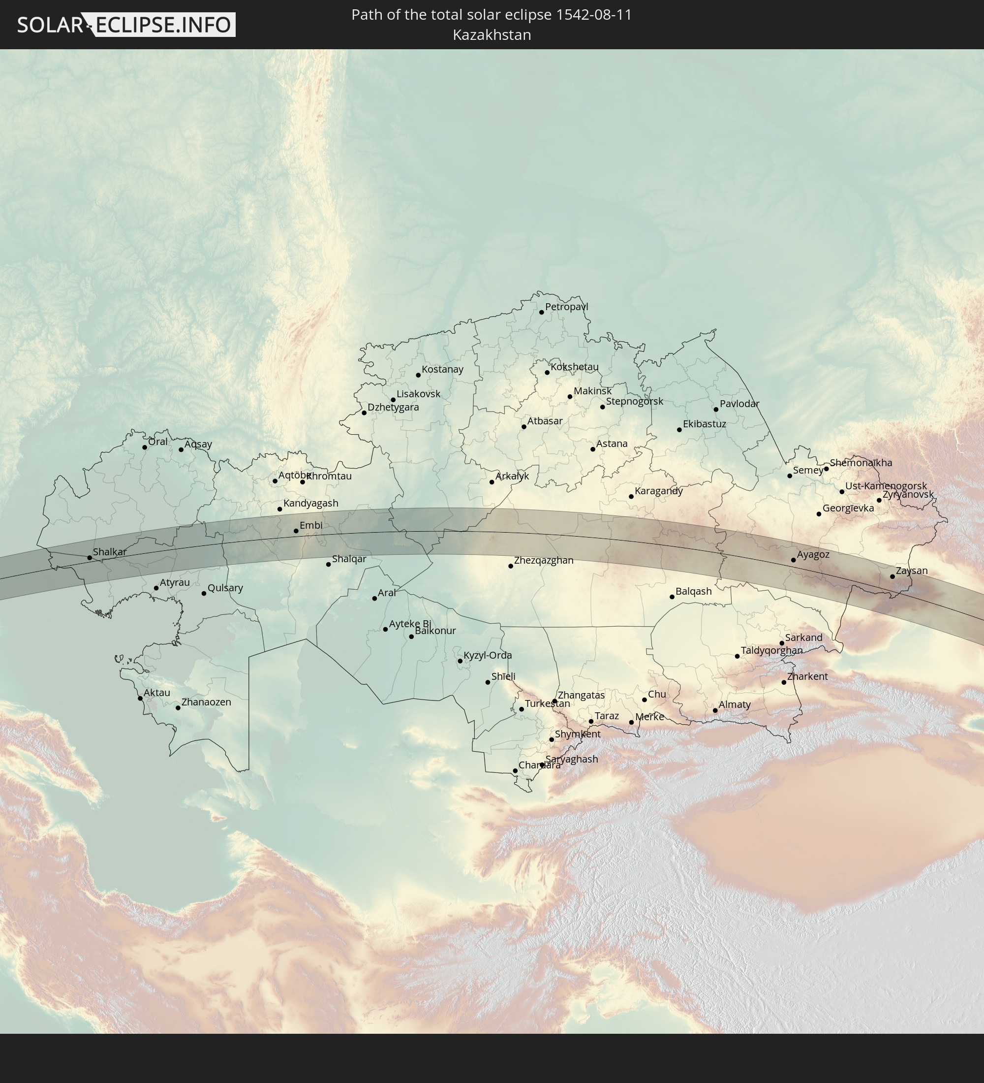 Kasachstan
 Volksrepublik China
 Mongolei
 Japan
Japan
 Föderierte Staaten von Mikronesien
In den folgenden Ländern ist die Sonnenfinsternis partiell zu sehen
 Russland
 United States Minor Outlying Islands
 Kiribati
 Grönland
 Spitzbergen
 Norwegen
 Schweden
 Polen
Polen
 Åland Islands
 Finnland
 Litauen
 Lettland
 Estland
 Ukraine
 Weißrussland
 Türkei
 Moldawien
 Saudi-Arabien
 Jordanien
 Libanon
 Syrien
 Irak
Irak
 Georgien
 Jemen
Jemen
 Armenien
 Iran
Iran
 Aserbaidschan
 Kasachstan
 Kuwait
 Bahrain
 Katar
Katar
 Vereinigte Arabische Emirate
 Oman
Oman
 Turkmenistan
 Usbekistan
 Afghanistan
 Pakistan
 Tadschikistan
 Indien
 Kirgisistan
 Volksrepublik China
 Nepal
Nepal
 Mongolei
 Bangladesch
 Bhutan
 Myanmar
 Indonesien
 Thailand
 Malaysia
 Laos
Laos
 Vietnam
 Kambodscha
 Singapur
 Australien
 Macau
Macau
 Hongkong
 Brunei
 Taiwan
 Philippinen
 Japan
Japan
 Osttimor
 Nordkorea
 Südkorea
 Palau
Palau
 Föderierte Staaten von Mikronesien
 Papua-Neuguinea
 Guam
Guam
 Nördliche Marianen
 Salomonen
 Neukaledonien
 Marshallinseln
 Vanuatu
 Nauru
Nauru
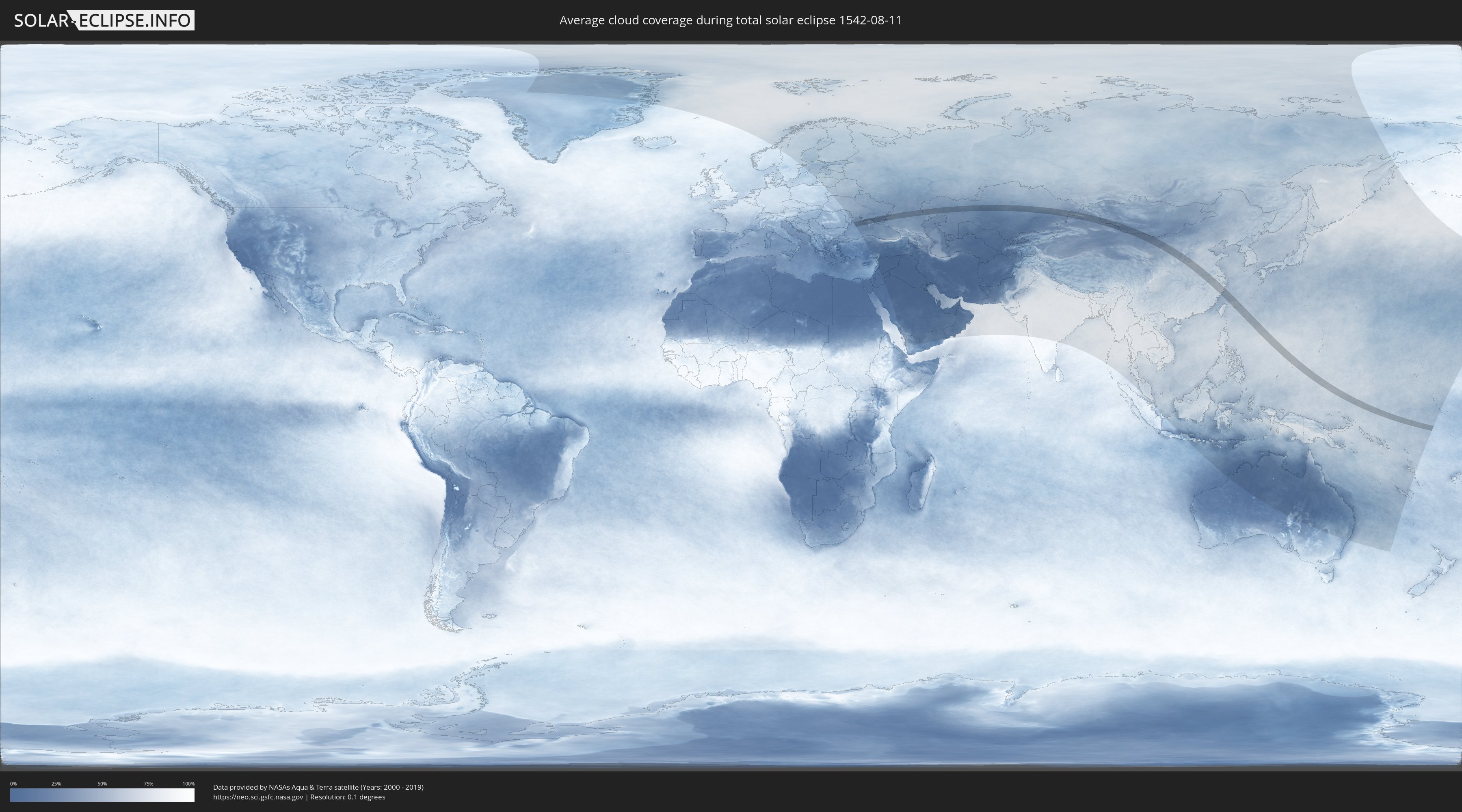
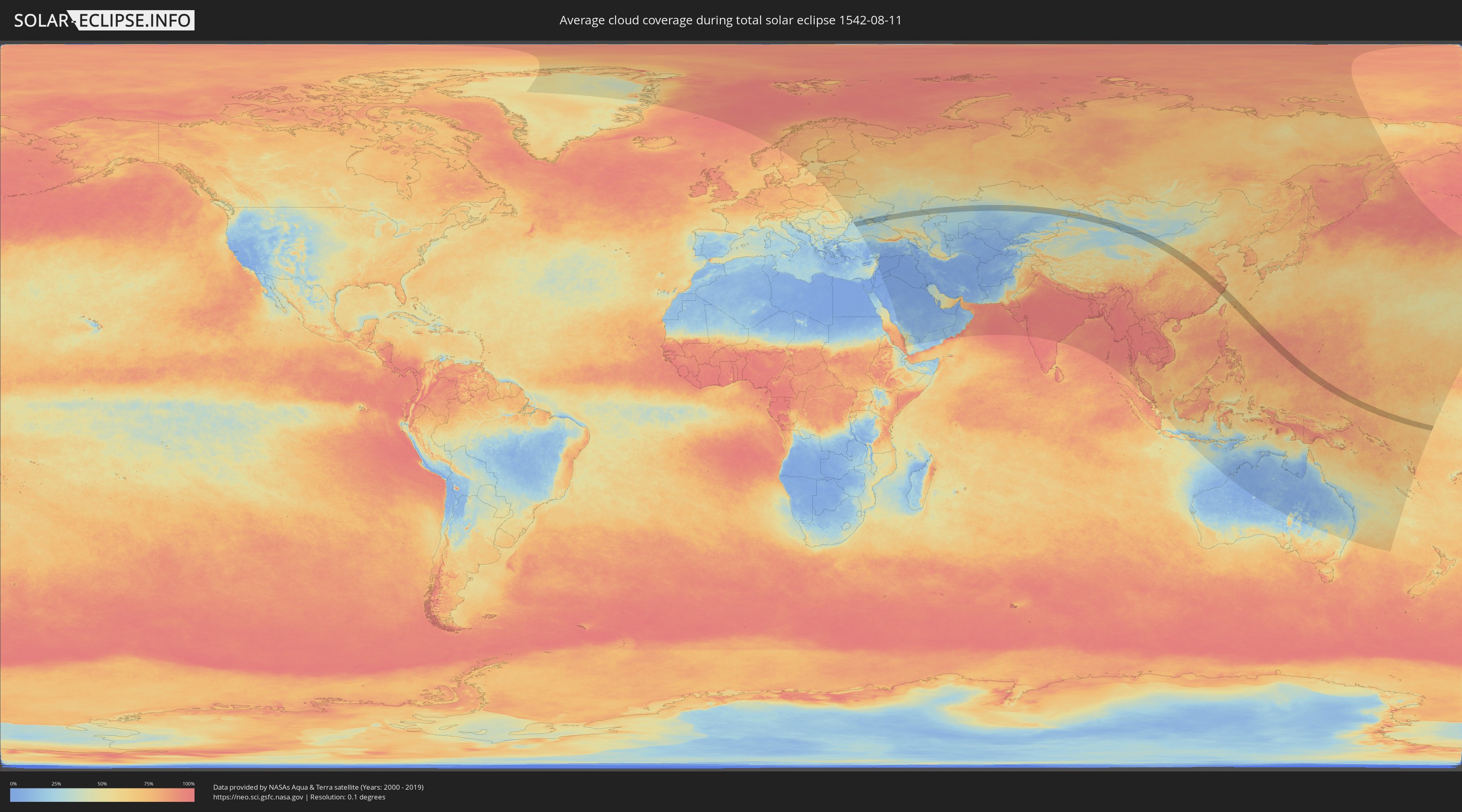
Wie wird das Wetter während der totalen Sonnenfinsternis am 11.08.1542?
Wo ist der beste Ort, um die totale Sonnenfinsternis vom 11.08.1542 zu beobachten?
Die folgenden Karten zeigen die durchschnittliche Bewölkung für den Tag, an dem die totale Sonnenfinsternis
stattfindet. Mit Hilfe der Karten lässt sich der Ort entlang des Finsternispfades eingrenzen,
der die besten Aussichen auf einen klaren wolkenfreien Himmel bietet.
Trotzdem muss man immer lokale Gegenenheiten beachten und sollte sich genau über das Wetter an seinem
gewählten Beobachtungsort informieren.
Die Daten stammen von den beiden NASA-Satelliten
AQUA und TERRA
und wurden über einen Zeitraum von 19 Jahren (2000 - 2019) gemittelt.
Detaillierte Länderkarten
 Russland
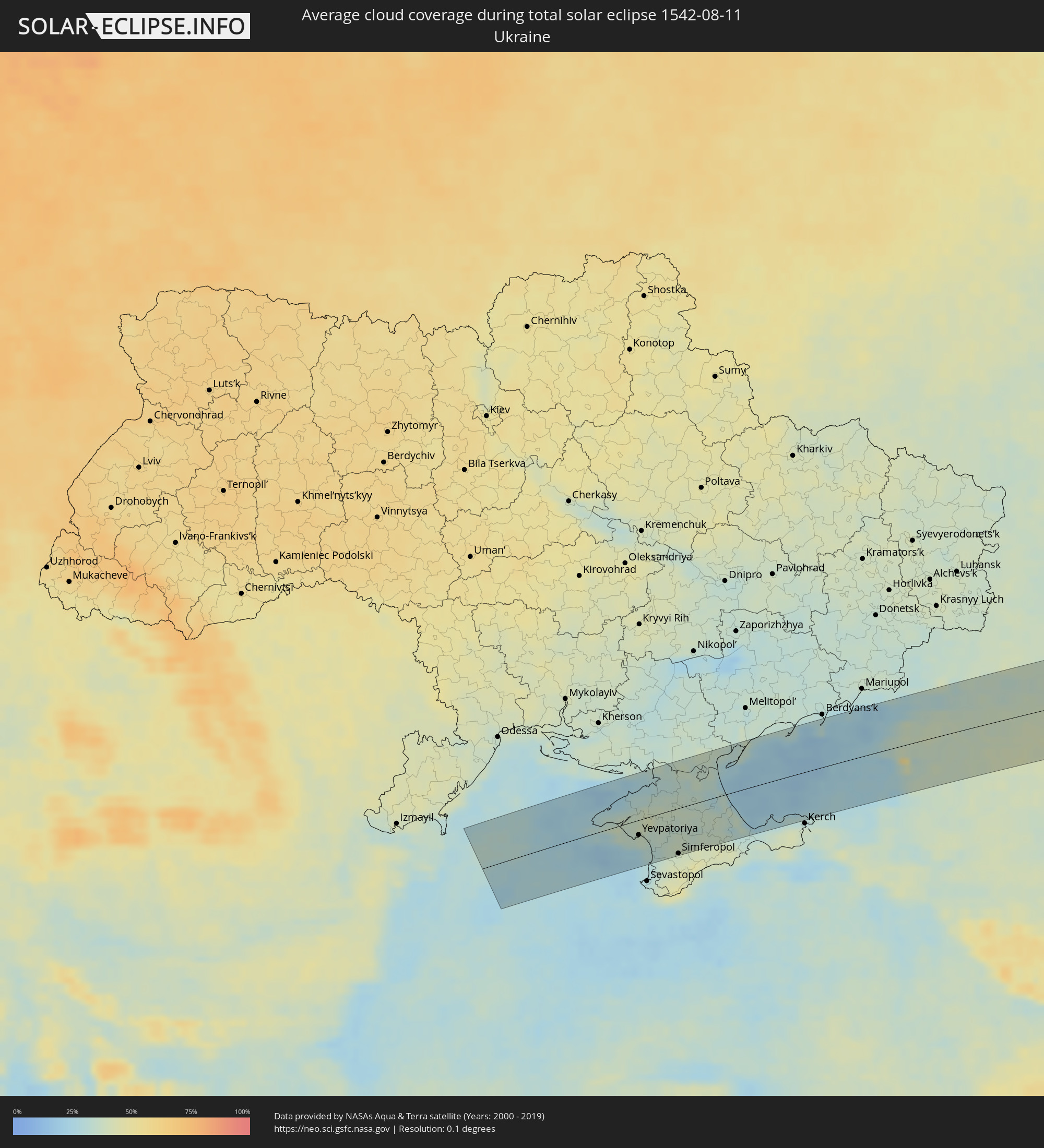 Ukraine
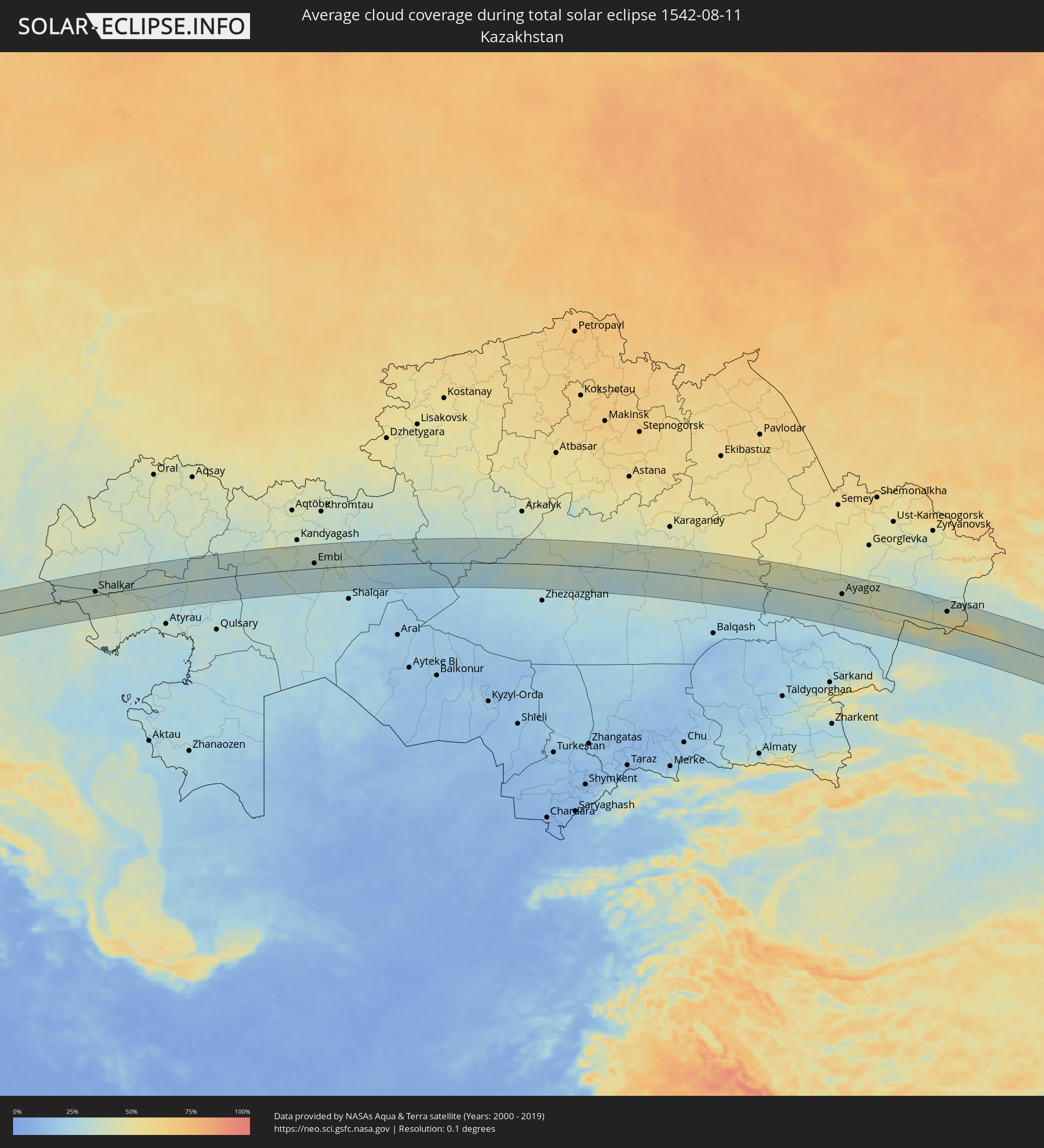 Kasachstan
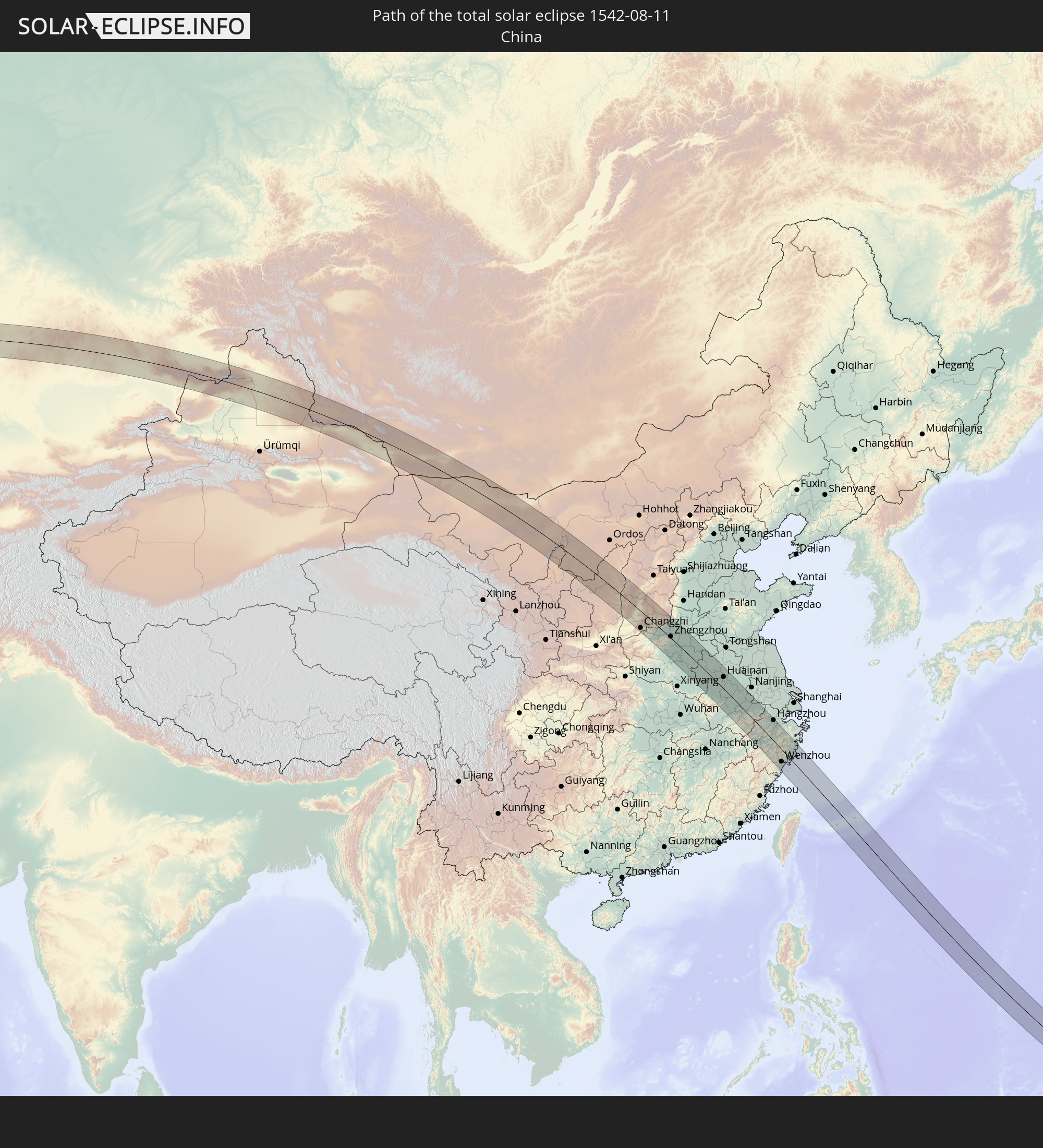
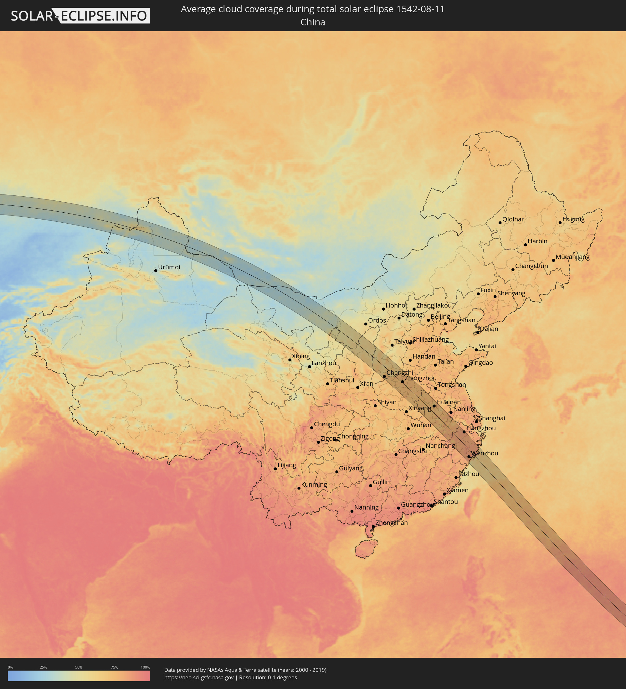 Volksrepublik China
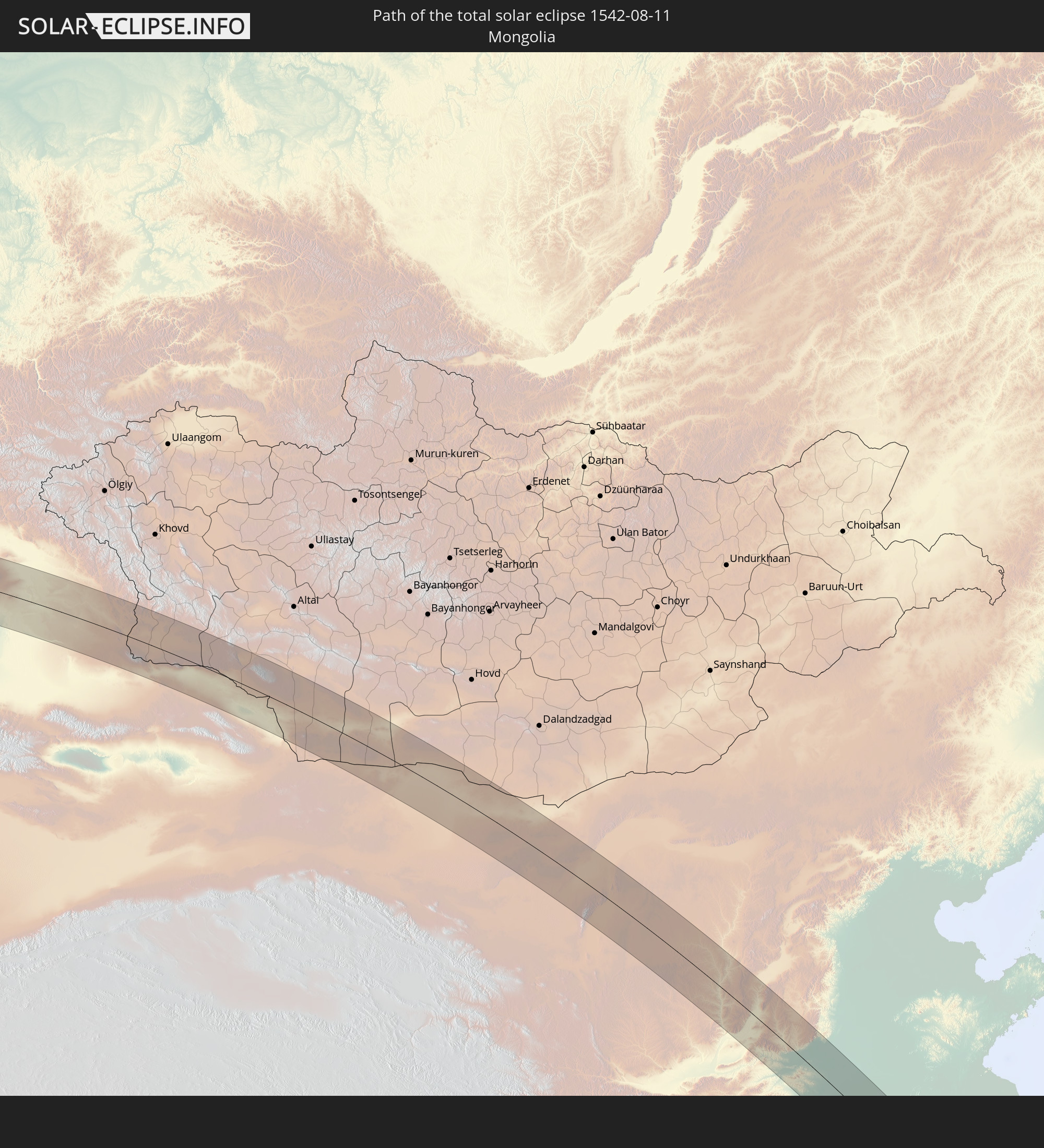
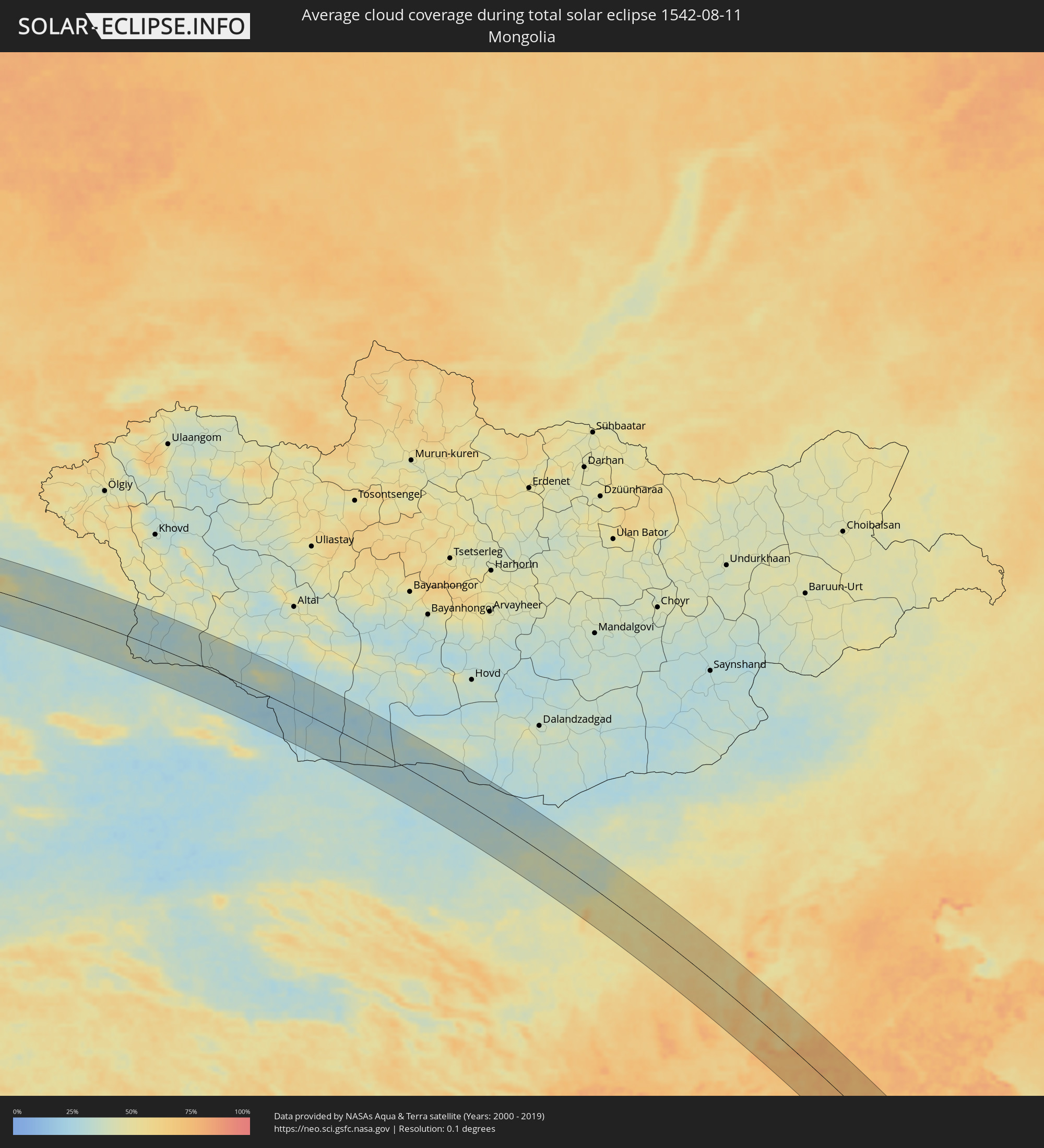 Mongolei
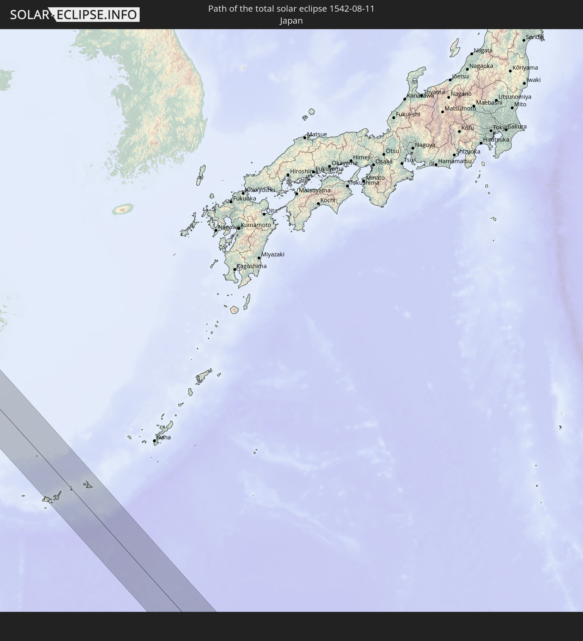
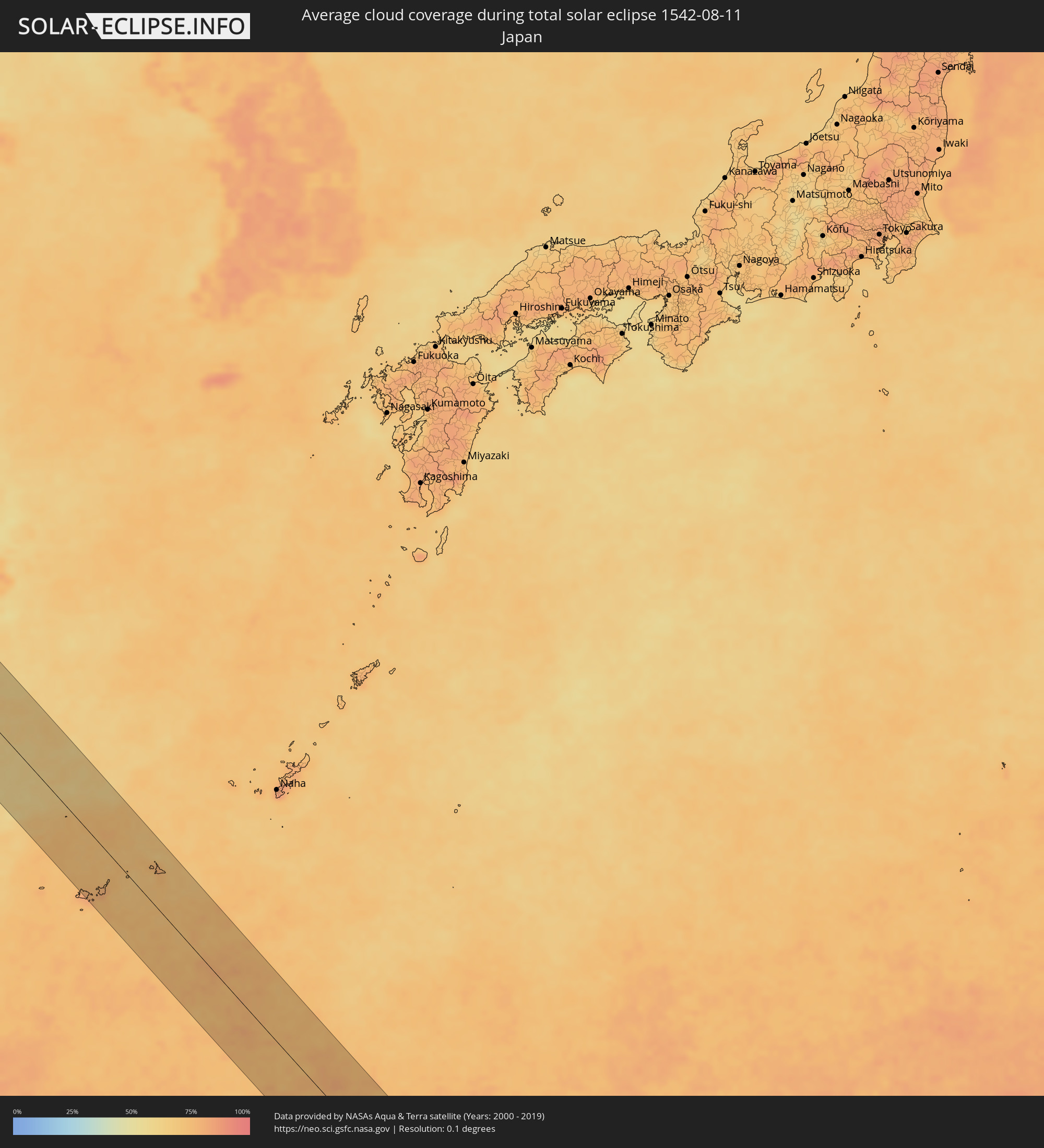 Japan
Japan
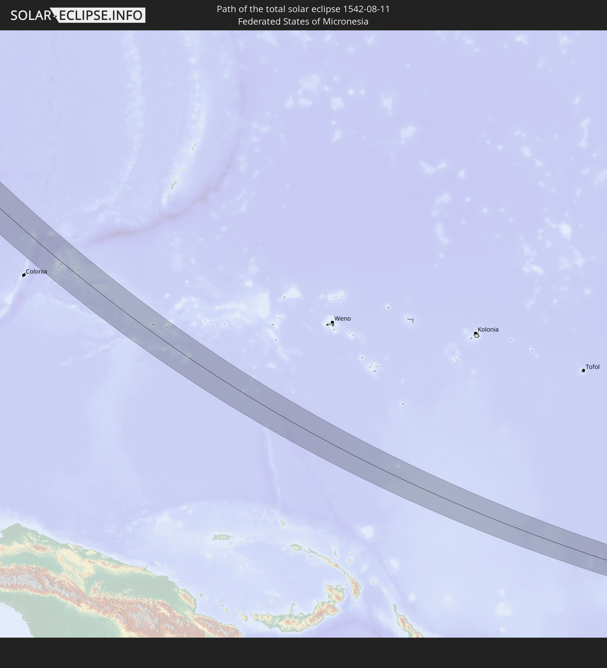
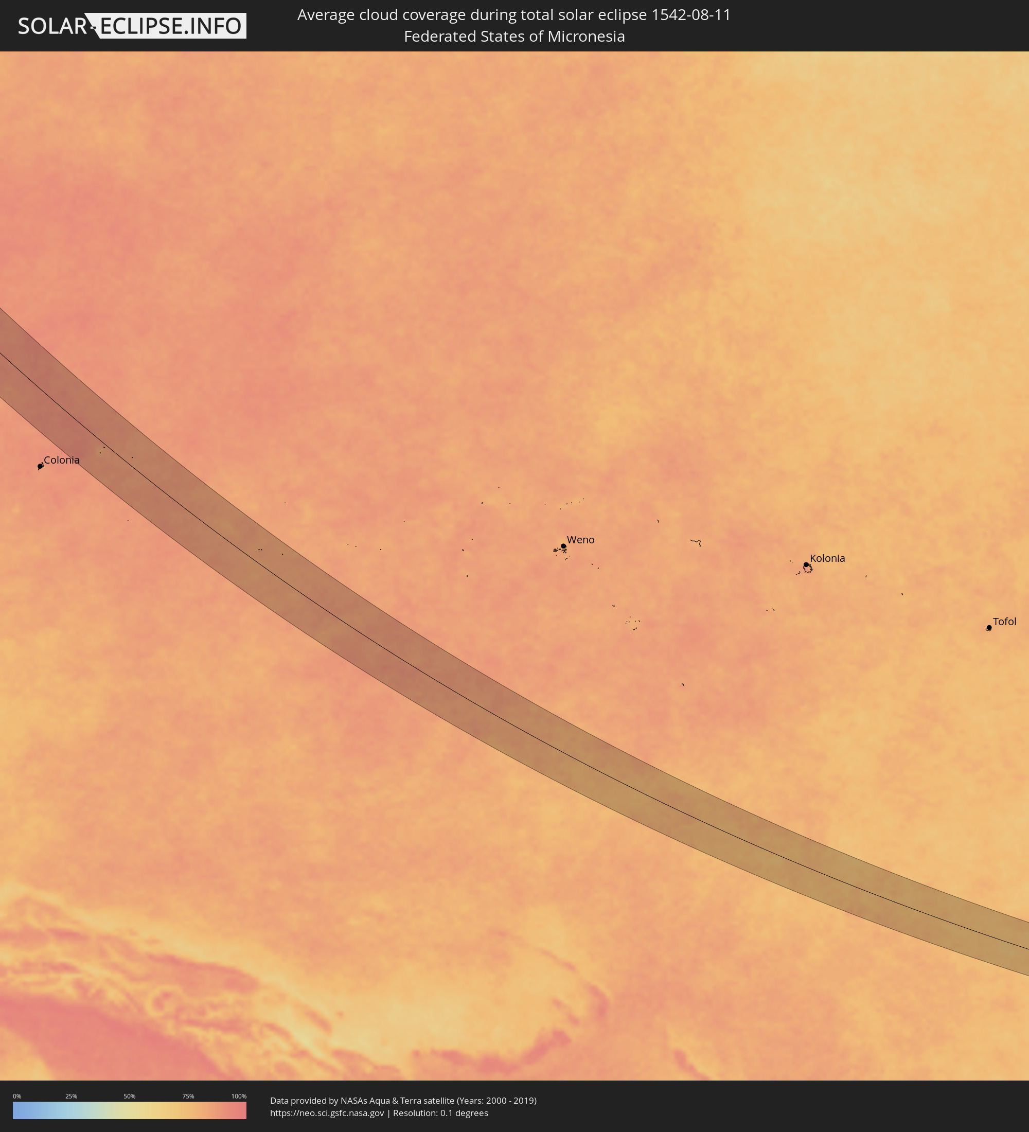 Föderierte Staaten von Mikronesien
Orte im Finsternispfad
Die nachfolgene Tabelle zeigt Städte und Orte mit mehr als 5.000 Einwohnern, die sich im Finsternispfad befinden. Städte mit mehr als 100.000 Einwohnern sind dick gekennzeichnet. Mit einem Klick auf den Ort öffnet sich eine Detailkarte die die Lage des jeweiligen Ortes zusammen mit dem Verlauf der zentralen Finsternis präsentiert.
| Ort | Typ | Dauer der Verfinsterung | Ortszeit bei maximaler Verfinsterung | Entfernung zur Zentrallinie | Ø Bewölkung |
|
Chernomorskoye, Republic of Crimea
|
total | - | 05:26:27 UTC+02:16 | 27 km | 31% |
|
Yevpatoriya, Republic of Crimea
|
total | - | 05:26:09 UTC+02:16 | 21 km | 35% |
|
Razdol’noye, Republic of Crimea
|
total | - | 05:26:34 UTC+02:16 | 37 km | 31% |
|
Novofedorovka, Republic of Crimea
|
total | - | 05:26:03 UTC+02:16 | 37 km | 31% |
|
Saki, Republic of Crimea
|
total | - | 05:26:05 UTC+02:16 | 33 km | 31% |
|
Vilino, Republic of Crimea
|
total | - | 05:25:51 UTC+02:16 | 66 km | 32% |
|
Krasnoperekops’k, Republic of Crimea
|
total | - | 05:26:41 UTC+02:16 | 50 km | 30% |
|
Pervomayskoye, Republic of Crimea
|
total | - | 05:26:30 UTC+02:16 | 23 km | 36% |
|
Gvardeyskoye, Republic of Crimea
|
total | - | 05:26:02 UTC+02:16 | 45 km | 36% |
|
Gresovskiy, Republic of Crimea
|
total | - | 05:25:57 UTC+02:16 | 56 km | 38% |
|
Molodyozhnoye, Republic of Crimea
|
total | - | 05:25:56 UTC+02:16 | 57 km | 38% |
|
Mirnoye, Republic of Crimea
|
total | - | 05:25:55 UTC+02:16 | 60 km | 38% |
|
Simferopol, Republic of Crimea
|
total | - | 05:25:54 UTC+02:16 | 64 km | 38% |
|
Oktyabr’skoye, Republic of Crimea
|
total | - | 05:26:09 UTC+02:16 | 29 km | 37% |
|
Petrovka, Republic of Crimea
|
total | - | 05:26:17 UTC+02:16 | 10 km | 36% |
|
Krasnogvardeyskoye, Republic of Crimea
|
total | - | 05:26:18 UTC+02:16 | 9 km | 36% |
|
Zuya, Republic of Crimea
|
total | - | 05:25:57 UTC+02:16 | 58 km | 38% |
|
Dzhankoy, Republic of Crimea
|
total | - | 05:26:27 UTC+02:16 | 11 km | 34% |
|
Belogorsk, Republic of Crimea
|
total | - | 05:25:56 UTC+02:16 | 64 km | 40% |
|
Novooleksiyivka, Kherson
|
total | - | 05:12:53 UTC+02:02 | 60 km | 34% |
|
Nizhnegorskiy, Republic of Crimea
|
total | - | 05:26:13 UTC+02:16 | 25 km | 35% |
|
Heniches’k, Kherson
|
total | - | 05:12:50 UTC+02:02 | 52 km | 34% |
|
Sovetskiy, Republic of Crimea
|
total | - | 05:26:07 UTC+02:16 | 40 km | 37% |
|
Kirovskoye, Republic of Crimea
|
total | - | 05:26:01 UTC+02:16 | 58 km | 36% |
|
Lenino, Republic of Crimea
|
total | - | 05:26:02 UTC+02:16 | 63 km | 35% |
|
Shchyolkino, Republic of Crimea
|
total | - | 05:26:08 UTC+02:16 | 50 km | 31% |
|
Dolzhanskaya, Krasnodarskiy
|
total | - | 05:41:18 UTC+02:30 | 39 km | 24% |
|
Primorsko-Akhtarsk, Krasnodarskiy
|
total | - | 05:40:50 UTC+02:30 | 32 km | 28% |
|
Yeysk, Krasnodarskiy
|
total | - | 05:41:21 UTC+02:30 | 37 km | 36% |
|
Staroshcherbinovskaya, Krasnodarskiy
|
total | - | 05:41:18 UTC+02:30 | 21 km | 39% |
|
Novoderevyankovskaya, Krasnodarskiy
|
total | - | 05:41:03 UTC+02:30 | 13 km | 34% |
|
Novominskaya, Krasnodarskiy
|
total | - | 05:41:03 UTC+02:30 | 18 km | 36% |
|
Kanevskaya, Krasnodarskiy
|
total | - | 05:40:52 UTC+02:30 | 43 km | 37% |
|
Staroderevyankovskaya, Krasnodarskiy
|
total | - | 05:40:54 UTC+02:30 | 39 km | 37% |
|
Starominskaya, Krasnodarskiy
|
total | - | 05:41:13 UTC+02:30 | 3 km | 36% |
|
Krylovskaya, Krasnodarskiy
|
total | - | 05:40:54 UTC+02:30 | 47 km | 37% |
|
Chelbasskaya, Krasnodarskiy
|
total | - | 05:40:48 UTC+02:30 | 62 km | 35% |
|
Leningradskaya, Krasnodarskiy
|
total | - | 05:41:04 UTC+02:30 | 26 km | 37% |
|
Azov, Rostov Oblast
|
total | - | 05:41:41 UTC+02:30 | 59 km | 34% |
|
Kuleshovka, Rostov Oblast
|
total | - | 05:41:40 UTC+02:30 | 53 km | 35% |
|
Kushchëvskaya, Krasnodarskiy
|
total | - | 05:41:16 UTC+02:30 | 4 km | 37% |
|
Samarskoye, Rostov Oblast
|
total | - | 05:41:34 UTC+02:30 | 35 km | 37% |
|
Rostov-na-Donu, Rostov Oblast
|
total | - | 05:41:48 UTC+02:30 | 66 km | 35% |
|
Pavlovskaya, Krasnodarskiy
|
total | - | 05:40:56 UTC+02:30 | 53 km | 38% |
|
Krylovskaya, Krasnodarskiy
|
total | - | 05:41:05 UTC+02:30 | 37 km | 41% |
|
Kagal’nitskaya, Rostov Oblast
|
total | - | 05:41:32 UTC+02:30 | 21 km | 38% |
|
Zernograd, Rostov Oblast
|
total | - | 05:41:31 UTC+02:30 | 14 km | 37% |
|
Bagayevskaya, Rostov Oblast
|
total | - | 05:41:54 UTC+02:30 | 64 km | 33% |
|
Yegorlykskaya, Rostov Oblast
|
total | - | 05:41:19 UTC+02:30 | 23 km | 40% |
|
Vesëlyy, Rostov Oblast
|
total | - | 05:41:44 UTC+02:30 | 33 km | 37% |
|
Tselina, Rostov Oblast
|
total | - | 05:41:19 UTC+02:30 | 33 km | 40% |
|
Gigant, Rostov Oblast
|
total | - | 05:41:19 UTC+02:30 | 41 km | 39% |
|
Sal’sk, Rostov Oblast
|
total | - | 05:41:18 UTC+02:30 | 48 km | 38% |
|
Proletarsk, Rostov Oblast
|
total | - | 05:41:30 UTC+02:30 | 27 km | 36% |
|
Romanovskaya, Rostov Oblast
|
total | - | 05:42:12 UTC+02:30 | 59 km | 33% |
|
Orlovskiy, Rostov Oblast
|
total | - | 05:41:39 UTC+02:30 | 14 km | 38% |
|
Tsimlyansk, Rostov Oblast
|
total | - | 05:42:17 UTC+02:30 | 69 km | 30% |
|
Volgodonsk, Rostov Oblast
|
total | - | 05:42:11 UTC+02:30 | 54 km | 33% |
|
Zimovniki, Rostov Oblast
|
total | - | 05:41:55 UTC+02:30 | 9 km | 37% |
|
Dubovskoye, Rostov Oblast
|
total | - | 05:42:10 UTC+02:30 | 33 km | 37% |
|
Kotel’nikovo, Volgograd
|
total | - | 05:42:23 UTC+02:30 | 50 km | 34% |
|
Zavetnoye, Rostov Oblast
|
total | - | 05:42:03 UTC+02:30 | 18 km | 35% |
|
Chyorny Yar, Astrakhan
|
total | - | 06:33:13 UTC+03:20 | 52 km | 35% |
|
Verkhniy Baskunchak, Astrakhan
|
total | - | 06:33:28 UTC+03:20 | 61 km | 38% |
|
Yenotayevka, Astrakhan
|
total | - | 06:32:44 UTC+03:20 | 51 km | 32% |
|
Kharabali, Astrakhan
|
total | - | 06:32:55 UTC+03:20 | 35 km | 37% |
|
Shalkar, Atyraū
|
total | - | 06:38:51 UTC+03:25 | 11 km | 34% |
|
Makhambet, Atyraū
|
total | - | 06:39:19 UTC+03:25 | 60 km | 33% |
|
Īnderbor, Atyraū
|
total | - | 06:40:05 UTC+03:25 | 35 km | 34% |
|
Miyaly, Atyraū
|
total | - | 06:41:02 UTC+03:25 | 53 km | 32% |
|
Bayganin, Aqtöbe
|
total | - | 06:41:41 UTC+03:25 | 15 km | 32% |
|
Shubarkuduk, Aqtöbe
|
total | - | 06:42:18 UTC+03:25 | 61 km | 36% |
|
Shubarshi, Aqtöbe
|
total | - | 06:42:10 UTC+03:25 | 6 km | 33% |
|
Embi, Aqtöbe
|
total | - | 06:42:48 UTC+03:25 | 16 km | 35% |
|
Qarazhal, Qaraghandy
|
total | - | 07:46:50 UTC+04:21 | 76 km | 29% |
|
Atasū, Qaraghandy
|
total | - | 07:47:53 UTC+04:21 | 5 km | 33% |
|
Aktau, Qaraghandy
|
total | - | 07:48:34 UTC+04:21 | 59 km | 33% |
|
Aqadyr, Qaraghandy
|
total | - | 07:48:41 UTC+04:21 | 34 km | 31% |
|
Ayagoz, East Kazakhstan
|
total | - | 07:55:49 UTC+04:21 | 21 km | 35% |
|
Urzhar, East Kazakhstan
|
total | - | 07:56:56 UTC+04:21 | 54 km | 34% |
|
Tūghyl, East Kazakhstan
|
total | - | 07:59:53 UTC+04:21 | 61 km | 37% |
|
Zaysan, East Kazakhstan
|
total | - | 08:00:38 UTC+04:21 | 46 km | 42% |
|
Dawukou, Ningsia Hui Autonomous Region
|
total | - | 12:14:45 UTC+08:00 | 35 km | 50% |
|
Wuda, Inner Mongolia
|
total | - | 12:14:44 UTC+08:00 | 22 km | 44% |
|
Shizuishan, Ningsia Hui Autonomous Region
|
total | - | 12:15:08 UTC+08:00 | 1 km | 49% |
|
Wuhai, Inner Mongolia
|
total | - | 12:14:41 UTC+08:00 | 44 km | 45% |
|
Yulin, Shaanxi
|
total | - | 12:21:15 UTC+08:00 | 76 km | 57% |
|
Linfen, Shanxi
|
total | - | 12:27:20 UTC+08:00 | 11 km | 62% |
|
Changzhi, Shanxi
|
total | - | 12:29:02 UTC+08:00 | 72 km | 72% |
|
Luoyang, Henan
|
total | - | 12:31:05 UTC+08:00 | 73 km | 73% |
|
Jincheng, Shanxi
|
total | - | 12:30:27 UTC+08:00 | 18 km | 64% |
|
Jiaozuo, Henan
|
total | - | 12:31:32 UTC+08:00 | 21 km | 77% |
|
Zhengzhou, Henan
|
total | - | 12:33:00 UTC+08:00 | 7 km | 76% |
|
Nangandao, Henan
|
total | - | 12:32:34 UTC+08:00 | 52 km | 77% |
|
Jiangguanchi, Henan
|
total | - | 12:34:17 UTC+08:00 | 35 km | 76% |
|
Luohe, Henan
|
total | - | 12:35:37 UTC+08:00 | 66 km | 78% |
|
Kaifeng, Henan
|
total | - | 12:34:03 UTC+08:00 | 51 km | 78% |
|
Zhoukou, Henan
|
total | - | 12:36:31 UTC+08:00 | 23 km | 73% |
|
Huaidian, Henan
|
total | - | 12:37:32 UTC+08:00 | 14 km | 73% |
|
Jieshou, Anhui
|
total | - | 12:38:22 UTC+08:00 | 6 km | 73% |
|
Bozhou, Anhui
|
total | - | 12:38:01 UTC+08:00 | 69 km | 76% |
|
Fuyang, Anhui
|
total | - | 12:39:46 UTC+08:00 | 6 km | 77% |
|
Huainan, Anhui
|
total | - | 12:42:13 UTC+08:00 | 50 km | 76% |
|
Hefei, Anhui
|
total | - | 12:44:03 UTC+08:00 | 10 km | 82% |
|
Chizhou, Anhui
|
total | - | 12:46:33 UTC+08:00 | 71 km | 75% |
|
Wusong, Anhui
|
total | - | 12:46:32 UTC+08:00 | 28 km | 74% |
|
Chaohu, Anhui
|
total | - | 12:45:30 UTC+08:00 | 29 km | 78% |
|
Wuhu, Anhui
|
total | - | 12:46:49 UTC+08:00 | 43 km | 75% |
|
Xuanzhou, Anhui
|
total | - | 12:48:09 UTC+08:00 | 39 km | 77% |
|
Jinhua, Zhejiang
|
total | - | 12:53:04 UTC+08:00 | 40 km | 78% |
|
Puyang, Zhejiang
|
total | - | 12:52:48 UTC+08:00 | 4 km | 82% |
|
Lishui, Zhejiang
|
total | - | 12:54:45 UTC+08:00 | 71 km | 82% |
|
Guli, Zhejiang
|
total | - | 12:54:08 UTC+08:00 | 30 km | 82% |
|
Yiwu, Zhejiang
|
total | - | 12:53:23 UTC+08:00 | 6 km | 83% |
|
Hangzhou, Zhejiang
|
total | - | 12:51:40 UTC+08:00 | 87 km | 84% |
|
Dongyang, Zhejiang
|
total | - | 12:53:43 UTC+08:00 | 13 km | 84% |
|
Zhuji, Zhejiang
|
total | - | 12:52:53 UTC+08:00 | 49 km | 81% |
|
Xiaoshan, Zhejiang
|
total | - | 12:52:04 UTC+08:00 | 84 km | 84% |
|
Wenzhou, Zhejiang
|
total | - | 12:56:52 UTC+08:00 | 51 km | 85% |
|
Linhai, Zhejiang
|
total | - | 12:55:59 UTC+08:00 | 46 km | 84% |
|
Huangyan, Zhejiang
|
total | - | 12:56:35 UTC+08:00 | 41 km | 87% |
|
Jiaojiang, Zhejiang
|
total | - | 12:56:48 UTC+08:00 | 56 km | 86% |
|
Ishigaki, Okinawa
|
total | - | 14:09:39 UTC+09:00 | 67 km | 74% |
|
Hirara, Okinawa
|
total | - | 14:10:28 UTC+09:00 | 53 km | 79% |