Totale Sonnenfinsternis vom 03.05.1715
| Wochentag: | Freitag |
| Maximale Dauer der Verfinsterung: | 04m14s |
| Maximale Breite des Finsternispfades: | 295 km |
| Saroszyklus: | 114 |
| Bedeckungsgrad: | 100% |
| Magnitude: | 1.0632 |
| Gamma: | 0.7112 |
Wo kann man die Sonnenfinsternis vom 03.05.1715 sehen?
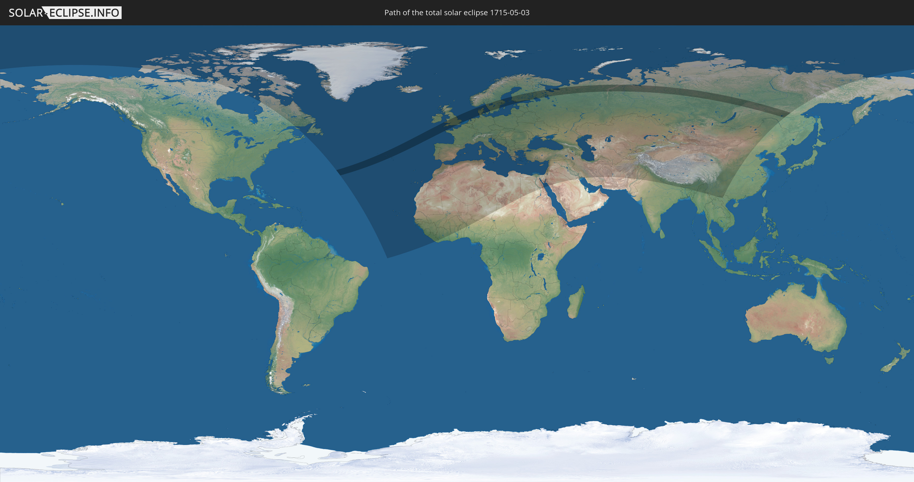
Die Sonnenfinsternis am 03.05.1715 kann man in 105 Ländern als partielle Sonnenfinsternis beobachten.
Der Finsternispfad verläuft durch 12 Länder. Nur in diesen Ländern ist sie als totale Sonnenfinsternis zu sehen.
In den folgenden Ländern ist die Sonnenfinsternis total zu sehen
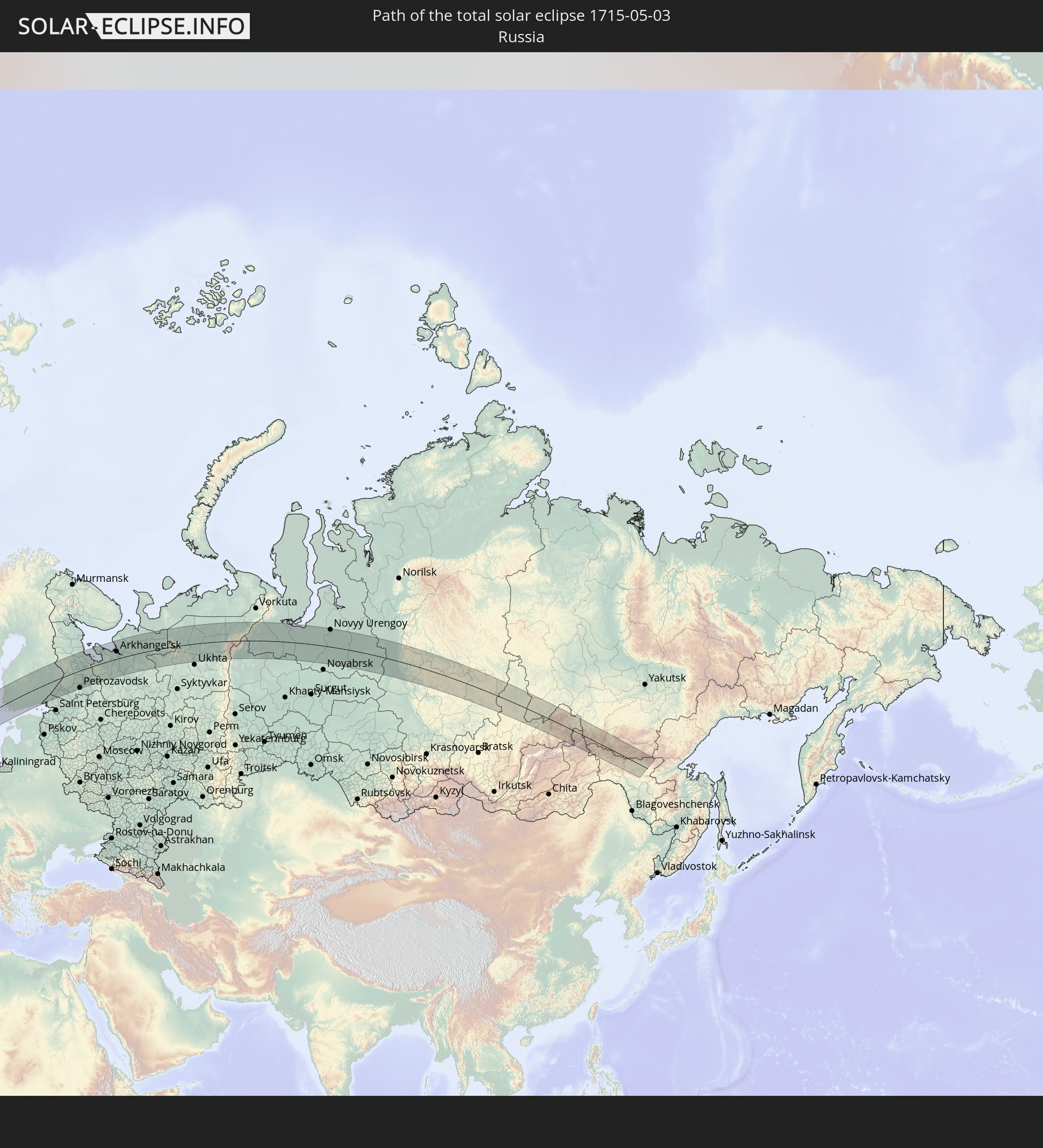 Russland
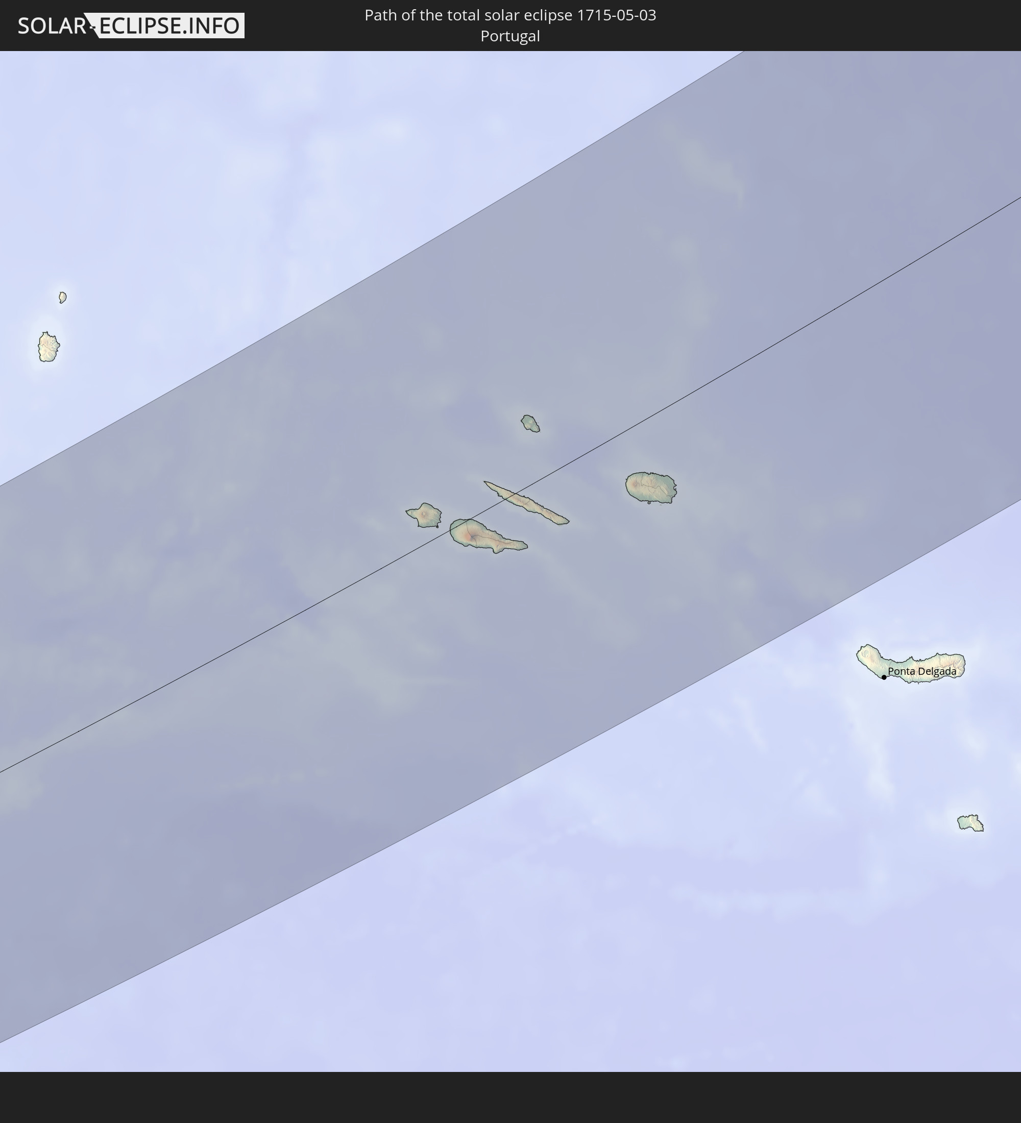 Portugal
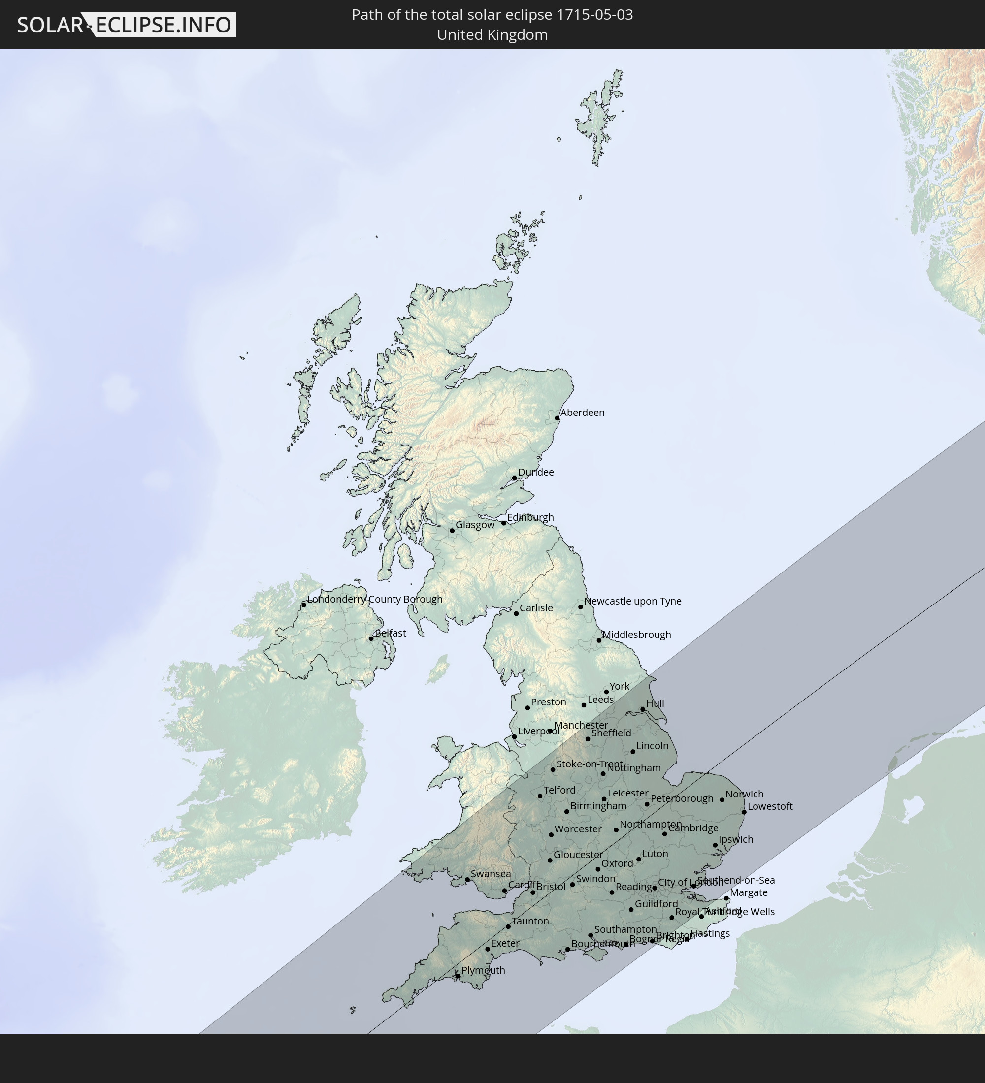 Vereinigtes Königreich
 Frankreich
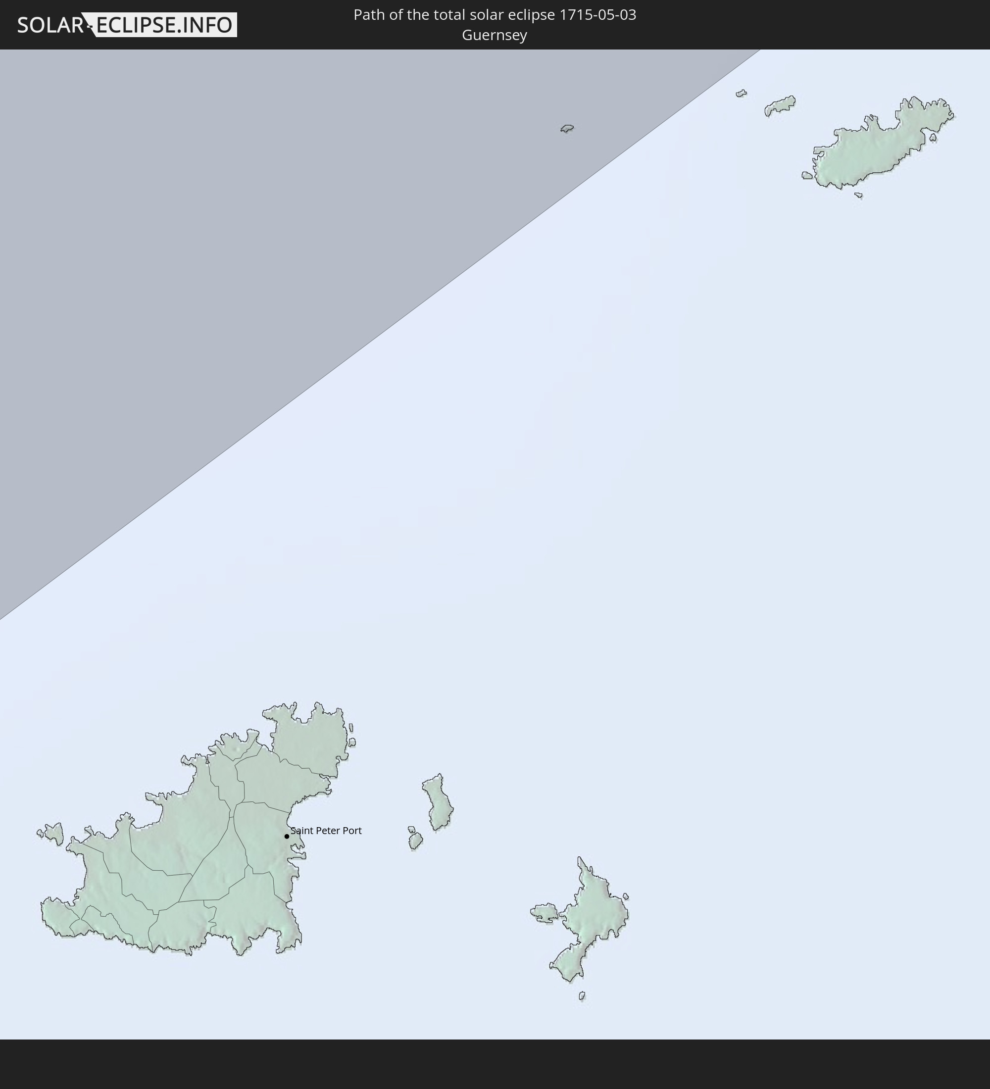 Guernsey
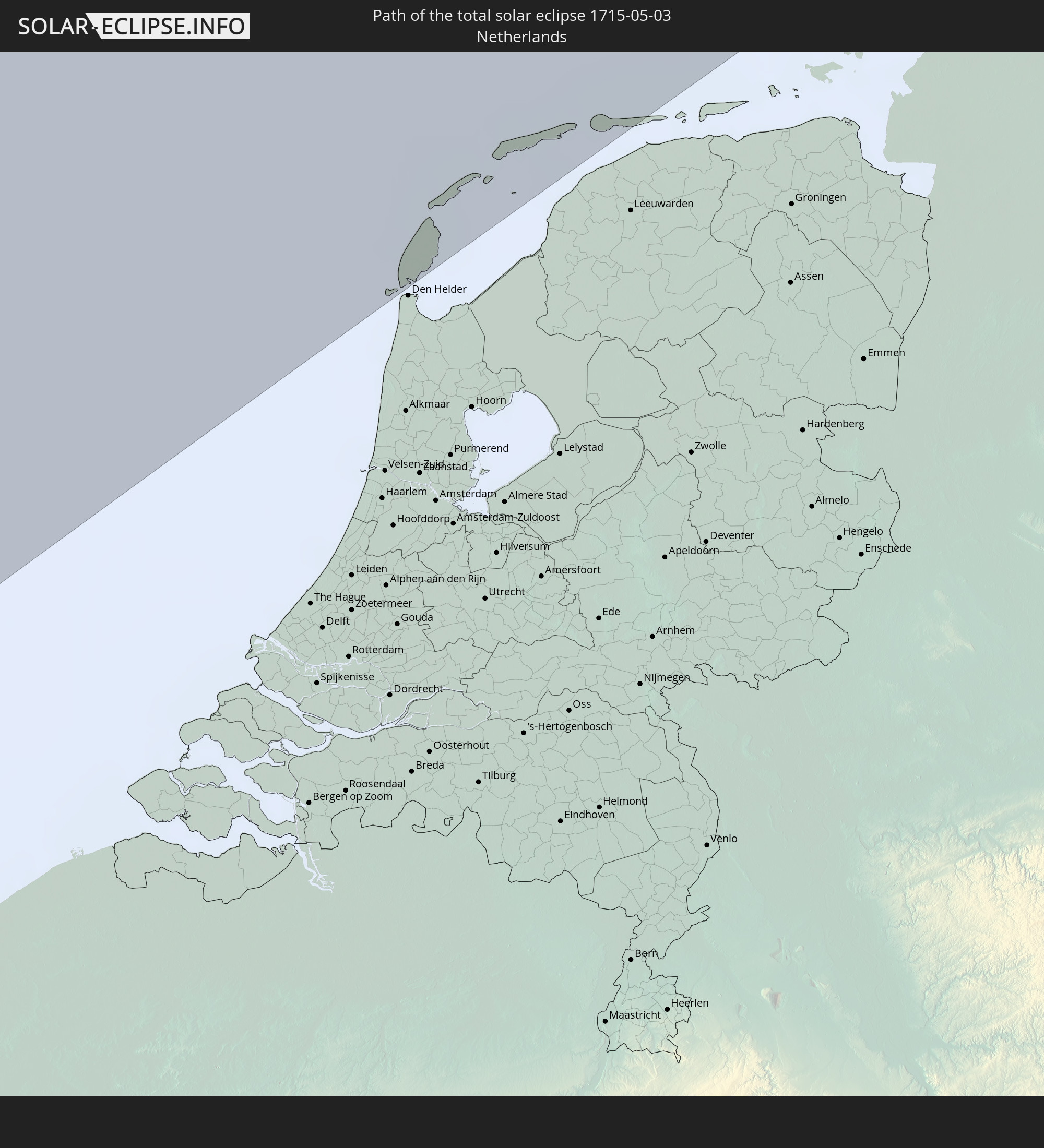 Niederlande
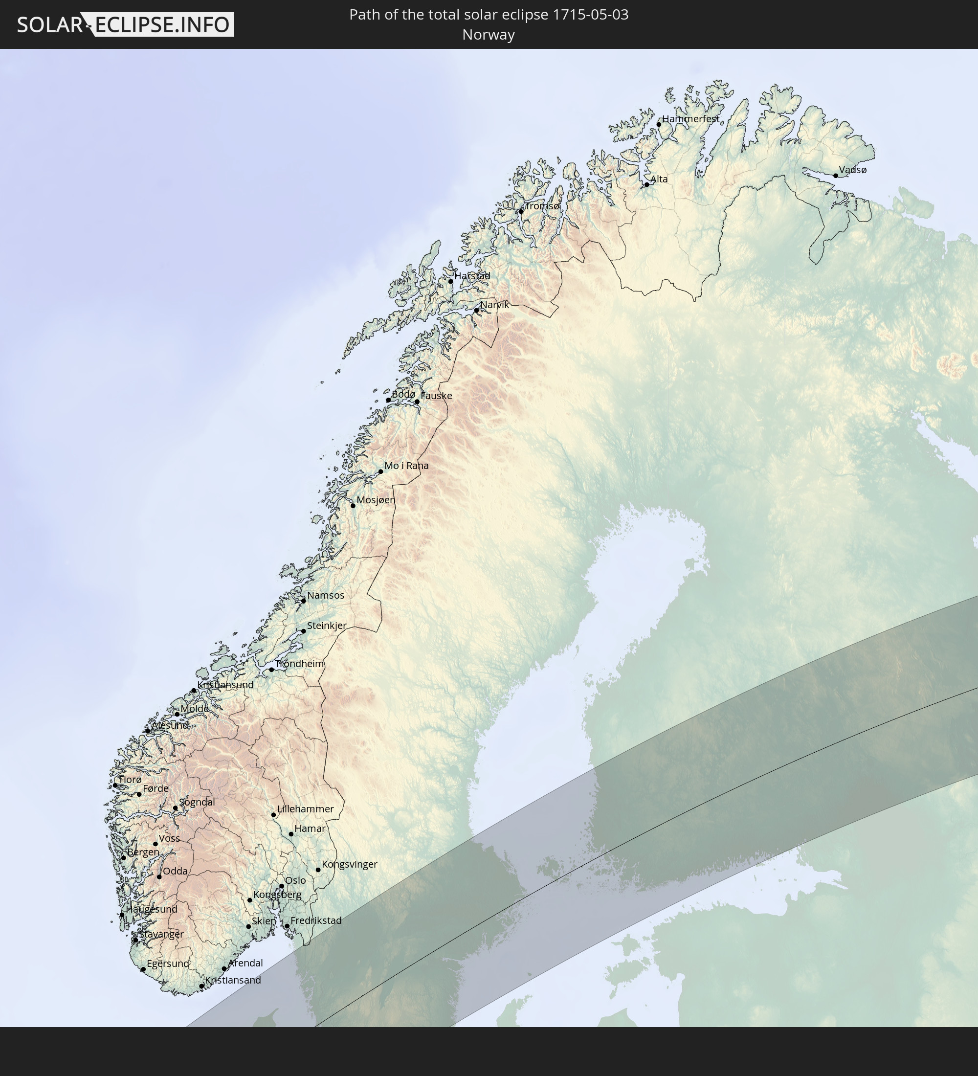 Norwegen
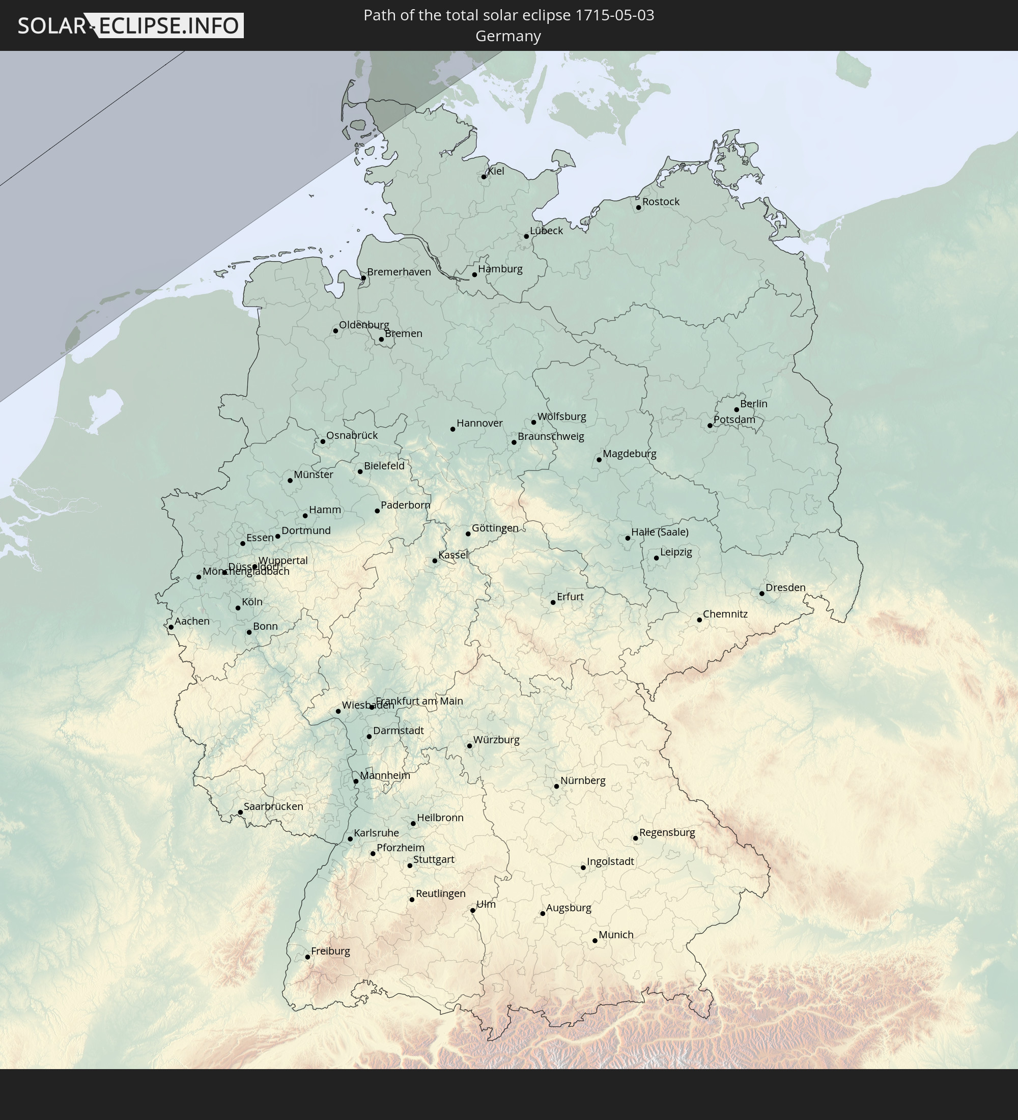 Deutschland
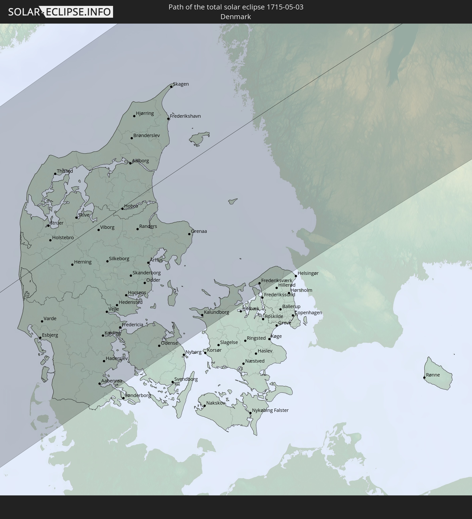 Dänemark
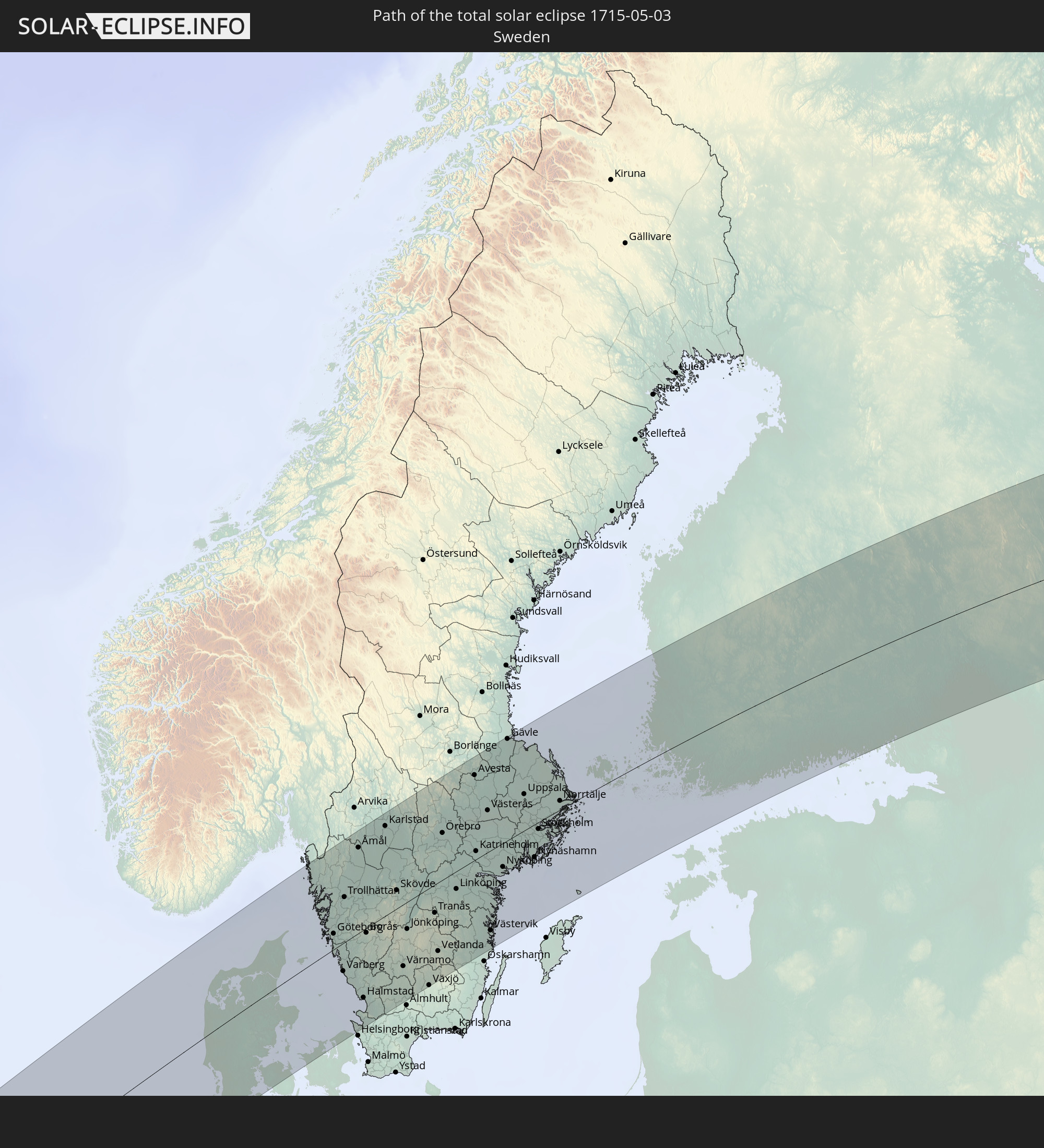 Schweden
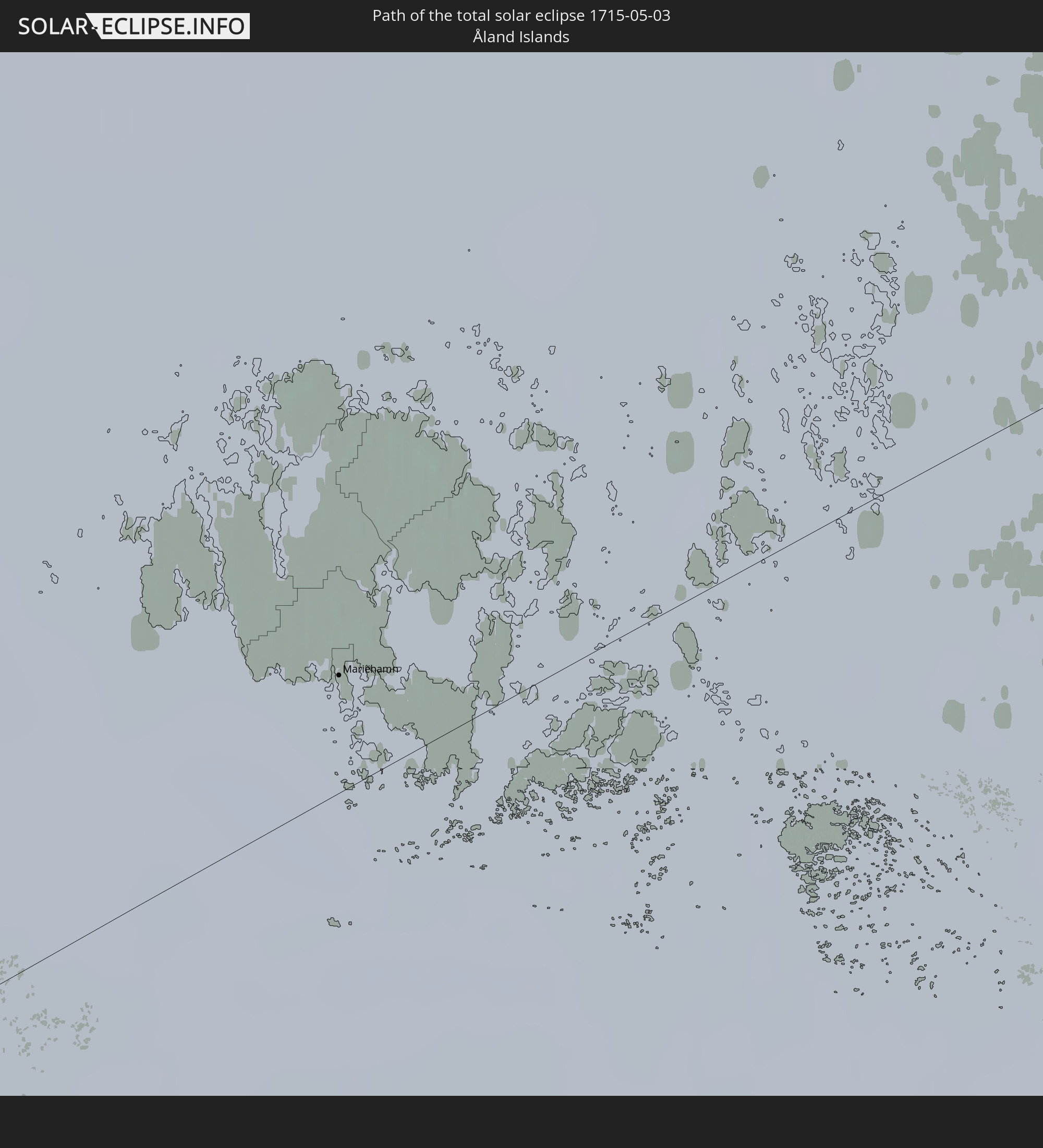 Åland Islands
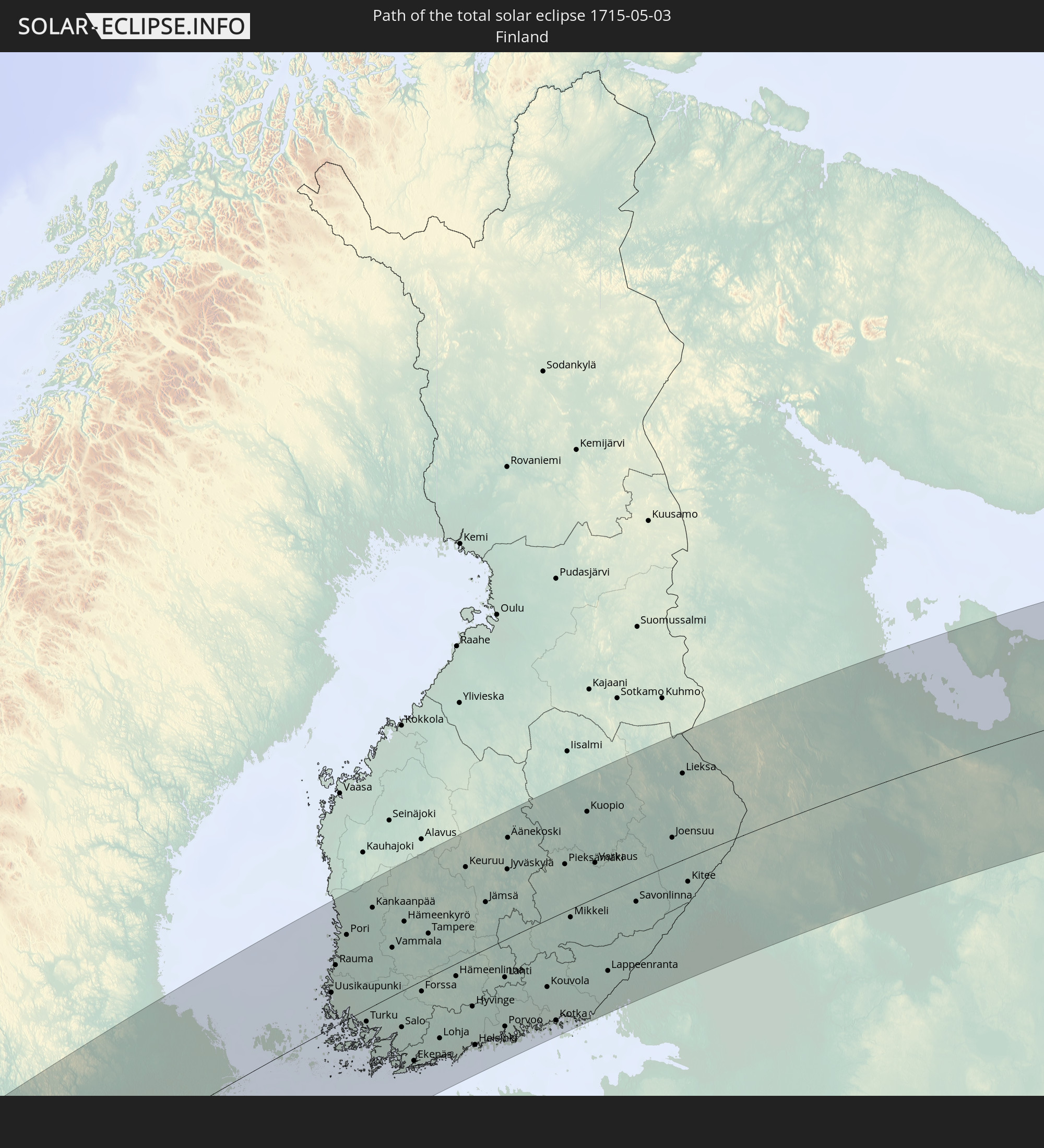 Finnland
In den folgenden Ländern ist die Sonnenfinsternis partiell zu sehen
 Russland
 Kanada
 Grönland
 Saint-Pierre und Miquelon
 Portugal
 Kap Verde
 Island
 Spanien
 Senegal
 Mauretanien
 Gambia
 Guinea-Bissau
 Guinea
 Sierra Leone
 Marokko
 Mali
Mali
 Liberia
 Irland
 Spitzbergen
 Algerien
 Vereinigtes Königreich
 Elfenbeinküste
 Färöer
 Burkina Faso
 Gibraltar
 Frankreich
 Isle of Man
 Ghana
Ghana
 Guernsey
 Jersey
 Togo
Togo
 Niger
Niger
 Benin
Benin
 Andorra
 Belgien
 Nigeria
 Niederlande
 Norwegen
 Luxemburg
 Deutschland
 Schweiz
 Italien
 Monaco
 Tunesien
 Dänemark
 Libyen
 Liechtenstein
 Österreich
 Schweden
 Tschechien
 San Marino
 Vatikanstadt
 Slowenien
 Tschad
 Kroatien
 Polen
Polen
 Malta
Malta
 Bosnien und Herzegowina
 Ungarn
 Slowakei
 Montenegro
 Serbien
 Albanien
 Åland Islands
 Griechenland
 Rumänien
 Mazedonien
 Finnland
 Litauen
 Lettland
 Estland
 Ukraine
 Bulgarien
 Weißrussland
 Ägypten
 Türkei
 Moldawien
 Republik Zypern
 Staat Palästina
 Israel
 Saudi-Arabien
 Jordanien
 Libanon
 Syrien
 Irak
Irak
 Georgien
 Armenien
 Iran
Iran
 Aserbaidschan
 Kasachstan
 Kuwait
 Turkmenistan
 Usbekistan
 Afghanistan
 Pakistan
 Tadschikistan
 Indien
 Kirgisistan
 Volksrepublik China
 Nepal
Nepal
 Mongolei
 Bangladesch
 Bhutan
 Myanmar
 Vietnam
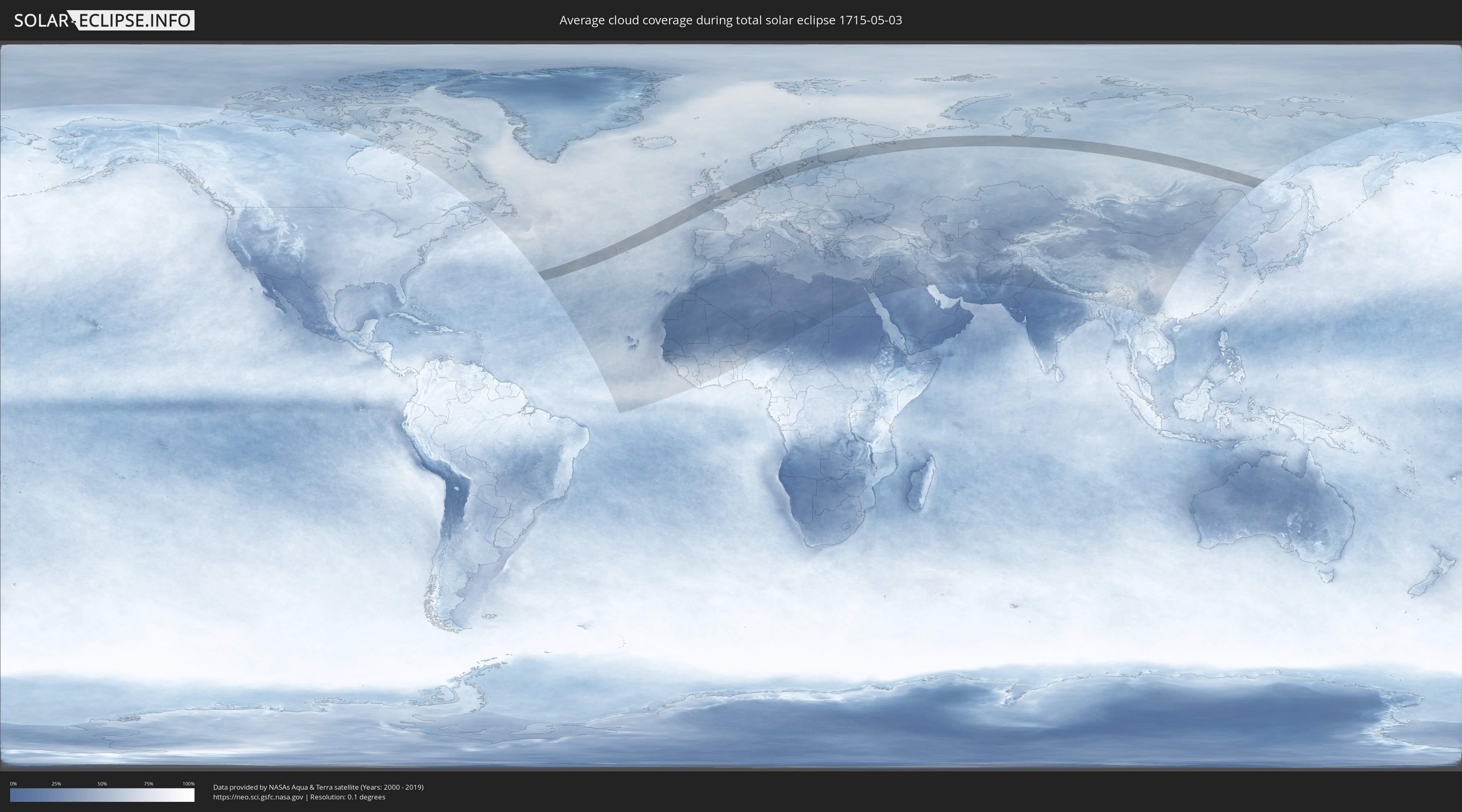
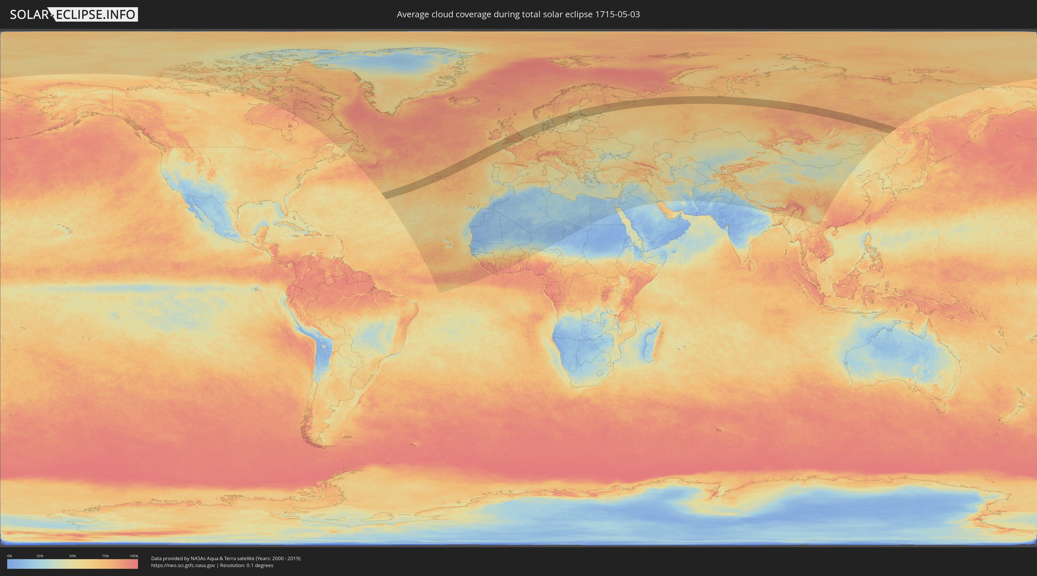
Wie wird das Wetter während der totalen Sonnenfinsternis am 03.05.1715?
Wo ist der beste Ort, um die totale Sonnenfinsternis vom 03.05.1715 zu beobachten?
Die folgenden Karten zeigen die durchschnittliche Bewölkung für den Tag, an dem die totale Sonnenfinsternis
stattfindet. Mit Hilfe der Karten lässt sich der Ort entlang des Finsternispfades eingrenzen,
der die besten Aussichen auf einen klaren wolkenfreien Himmel bietet.
Trotzdem muss man immer lokale Gegenenheiten beachten und sollte sich genau über das Wetter an seinem
gewählten Beobachtungsort informieren.
Die Daten stammen von den beiden NASA-Satelliten
AQUA und TERRA
und wurden über einen Zeitraum von 19 Jahren (2000 - 2019) gemittelt.
Detaillierte Länderkarten
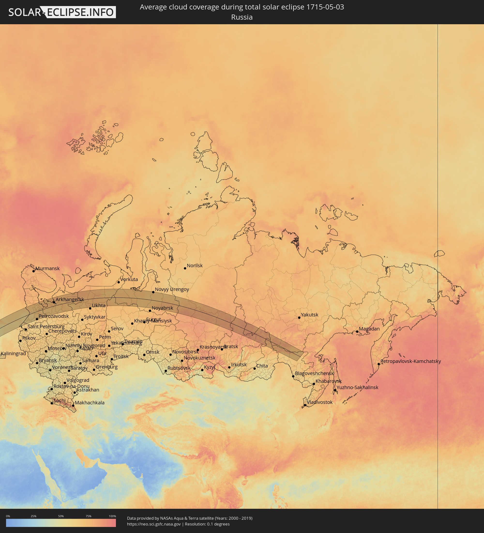 Russland
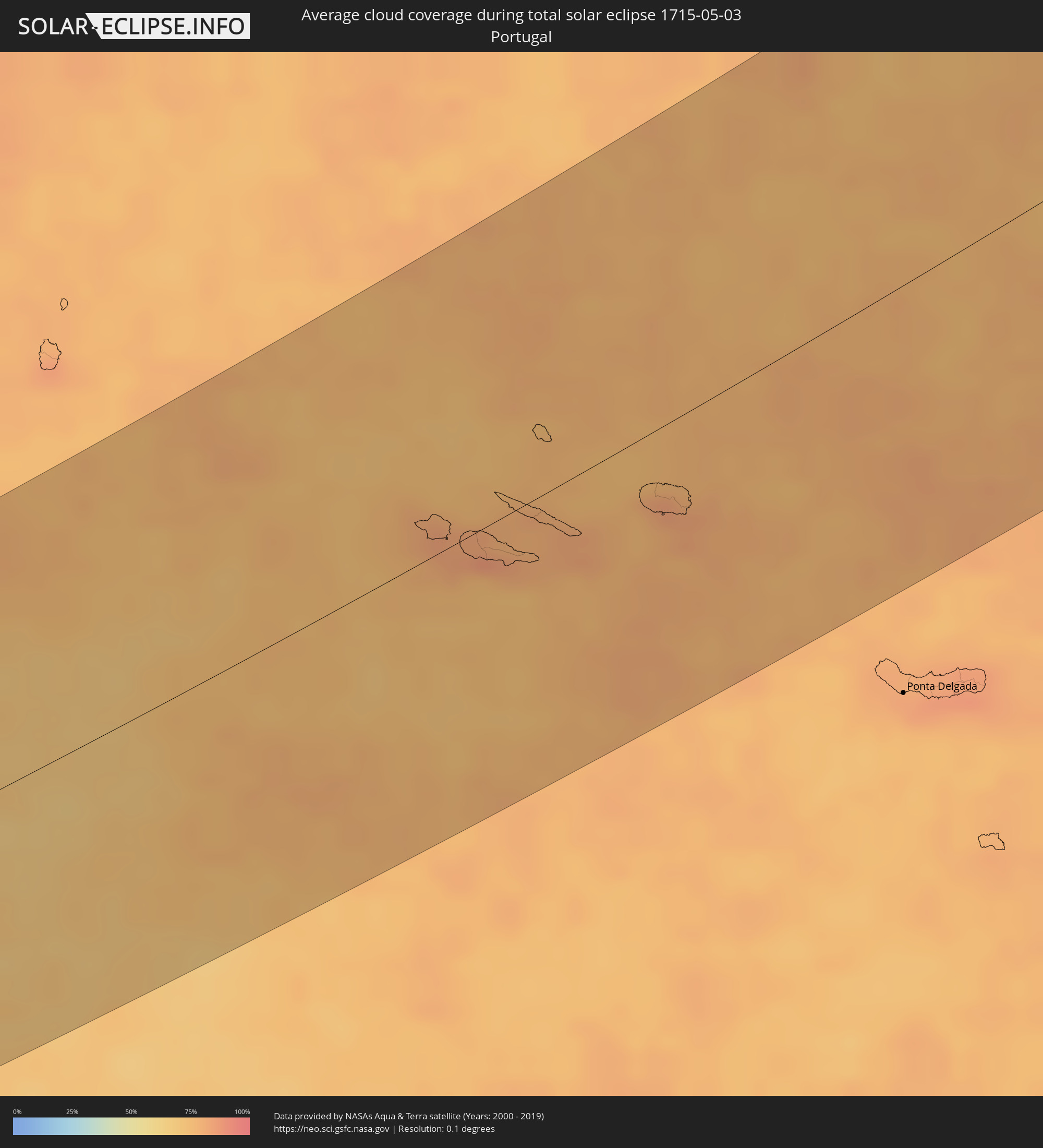 Portugal
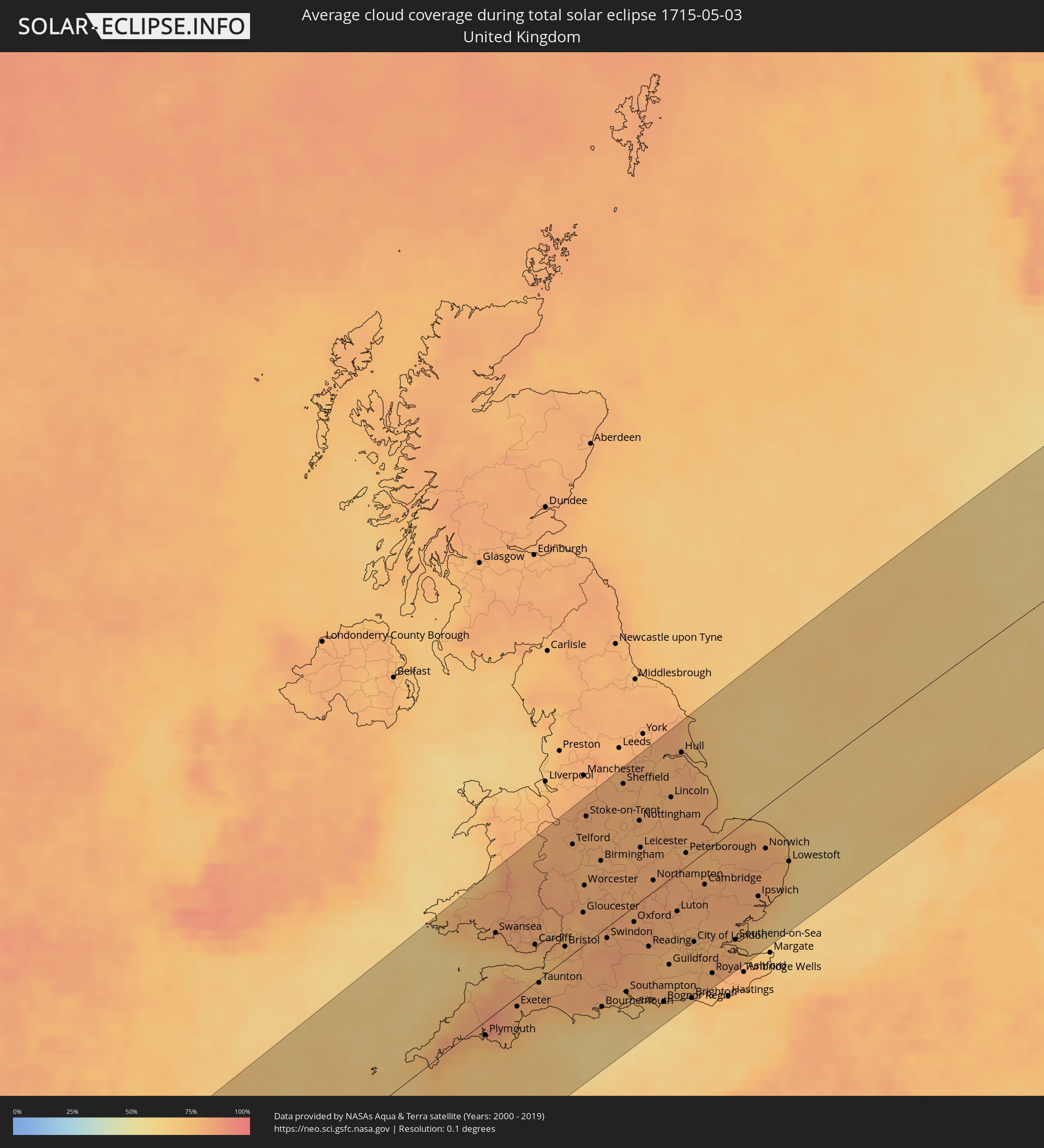 Vereinigtes Königreich
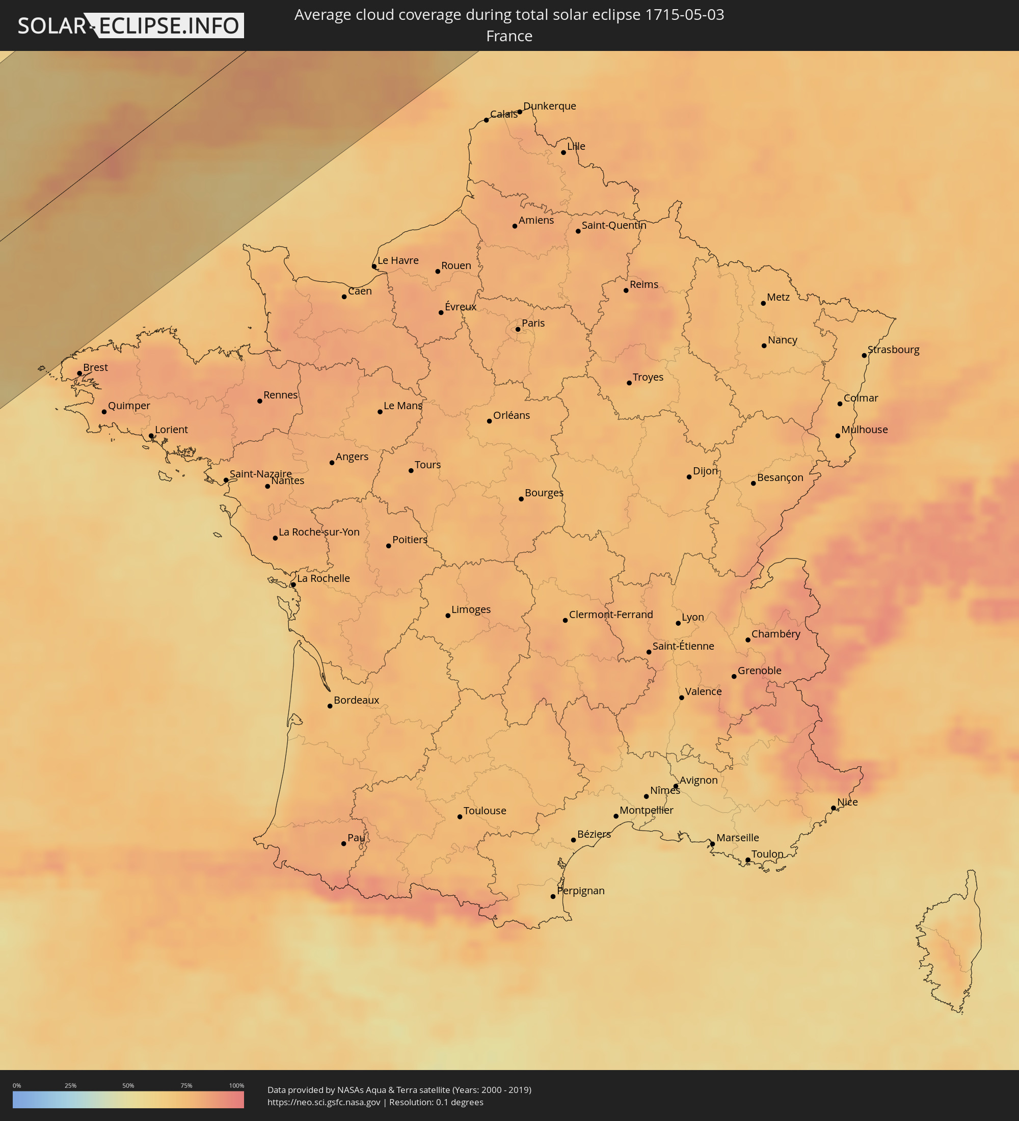 Frankreich
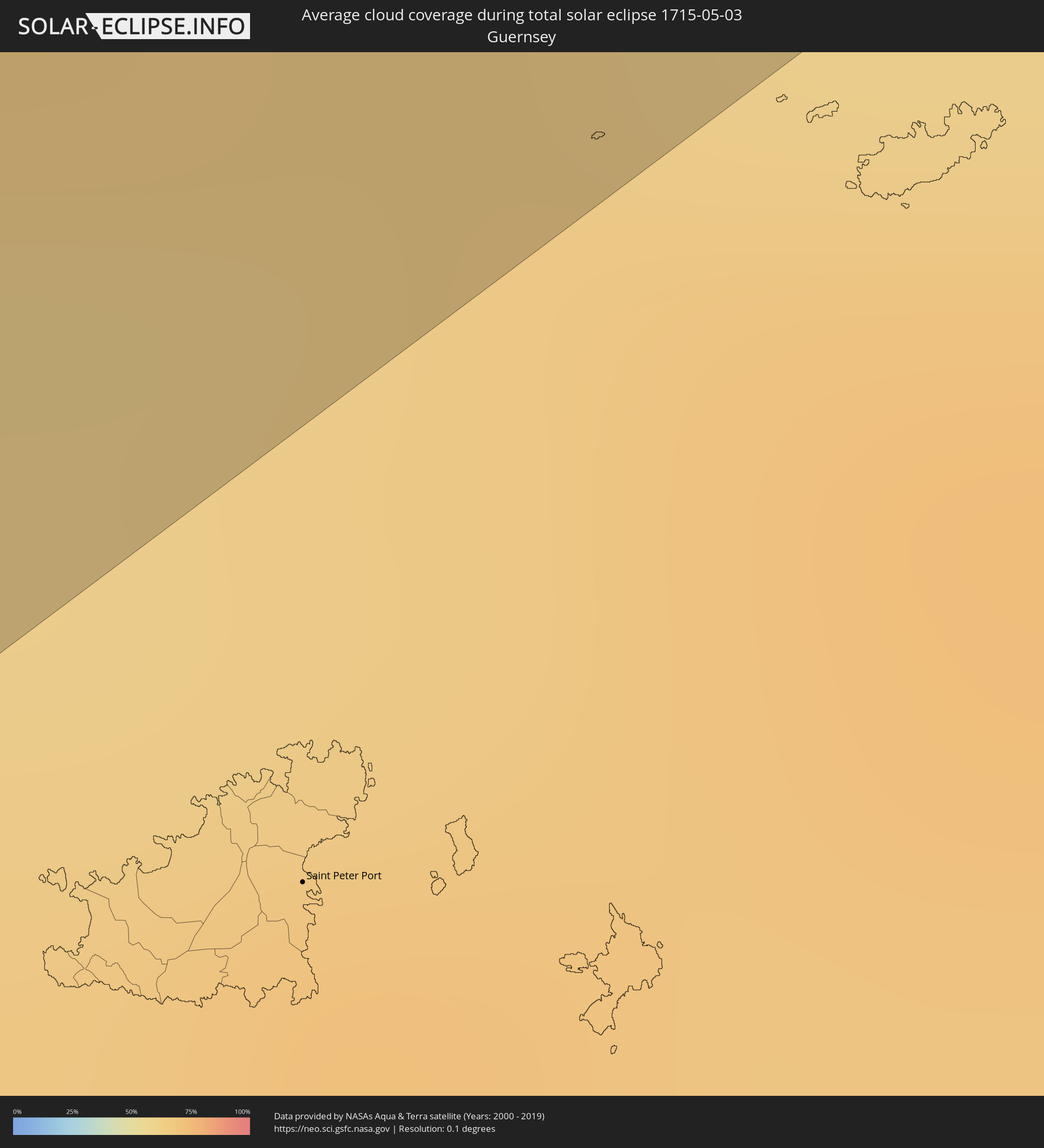 Guernsey
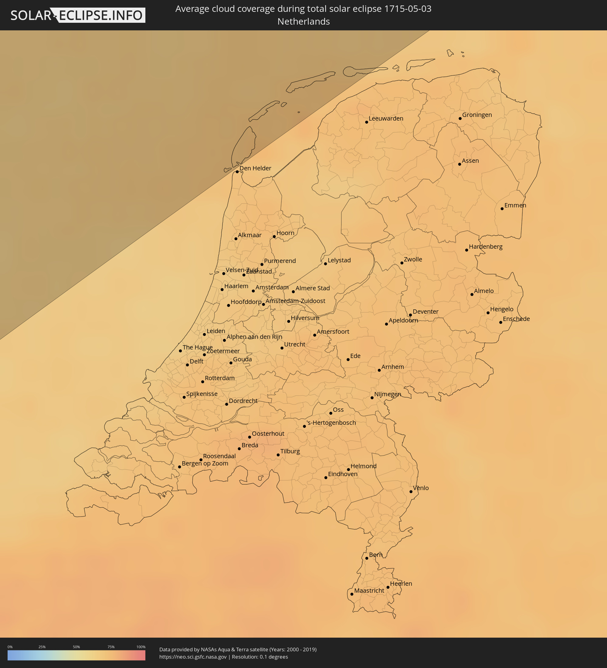 Niederlande
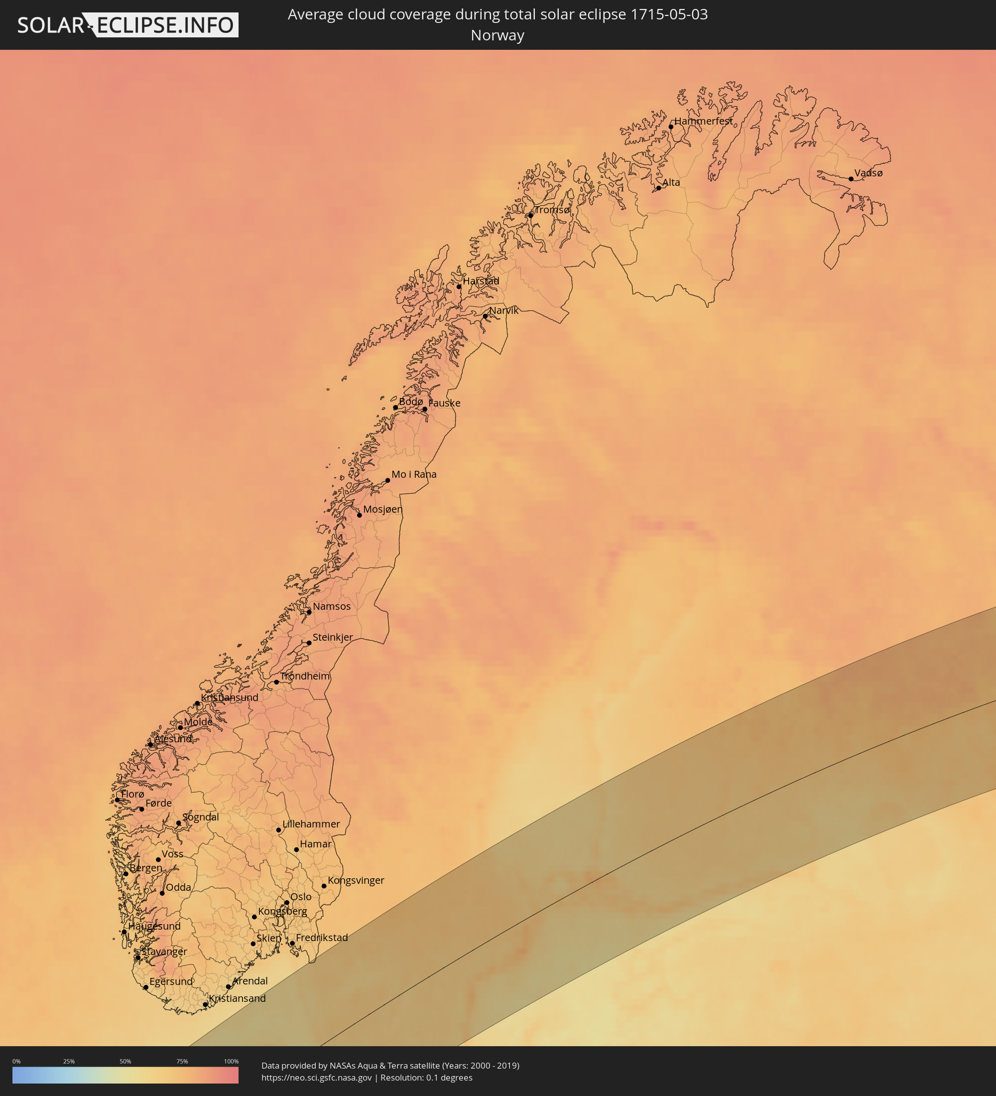 Norwegen
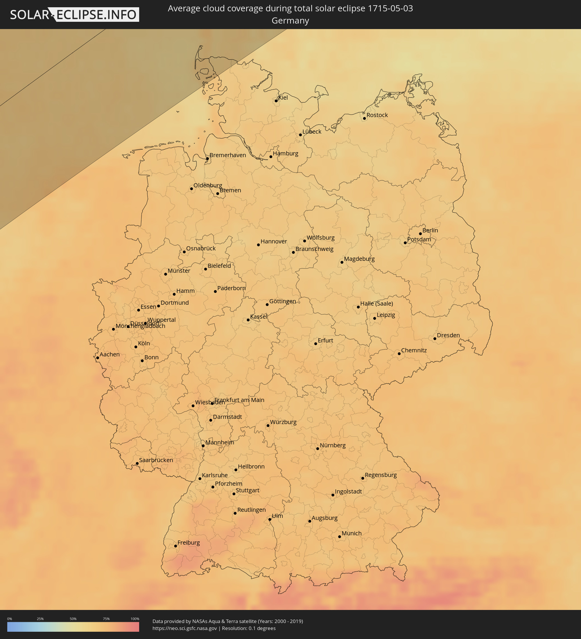 Deutschland
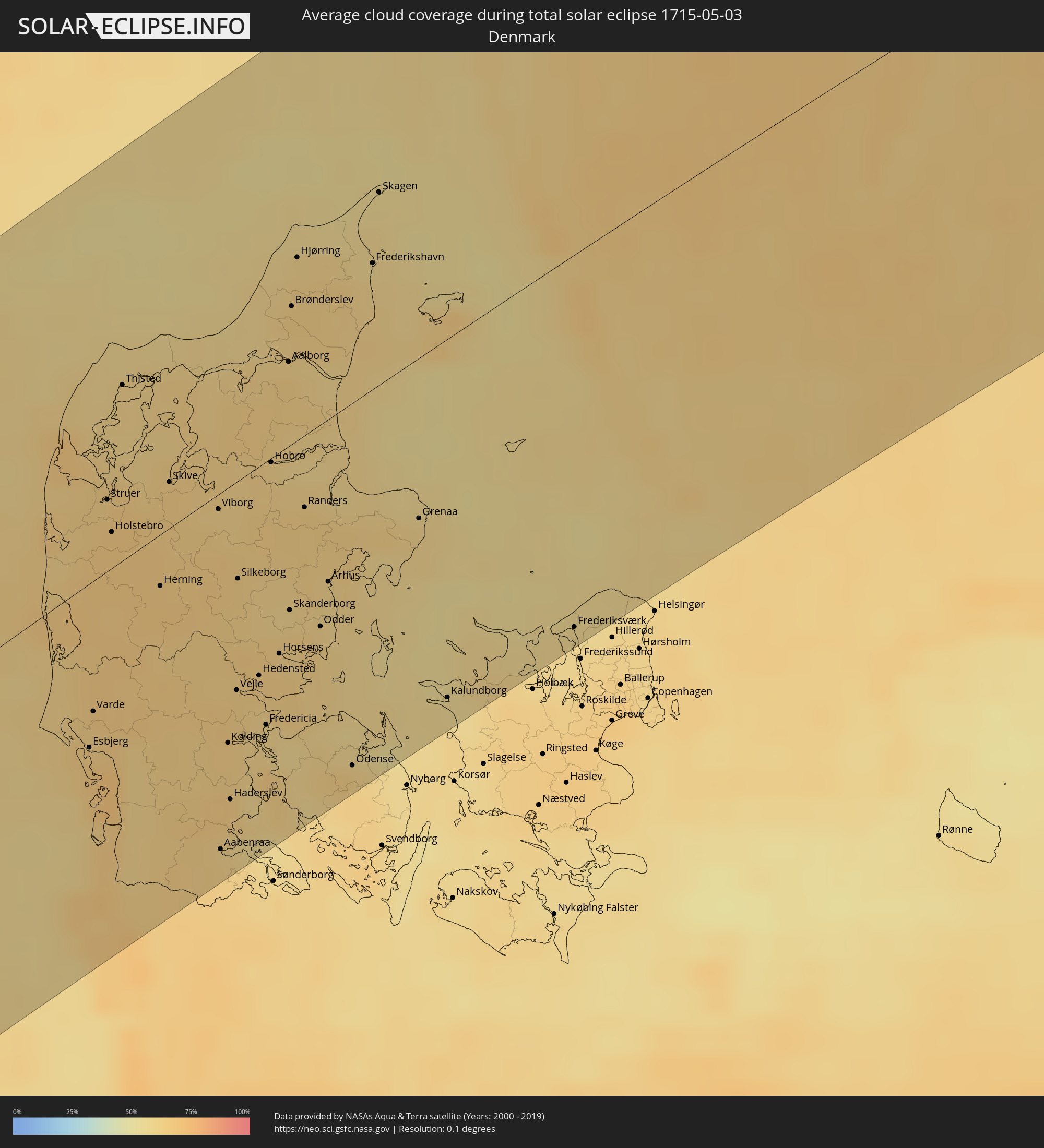 Dänemark
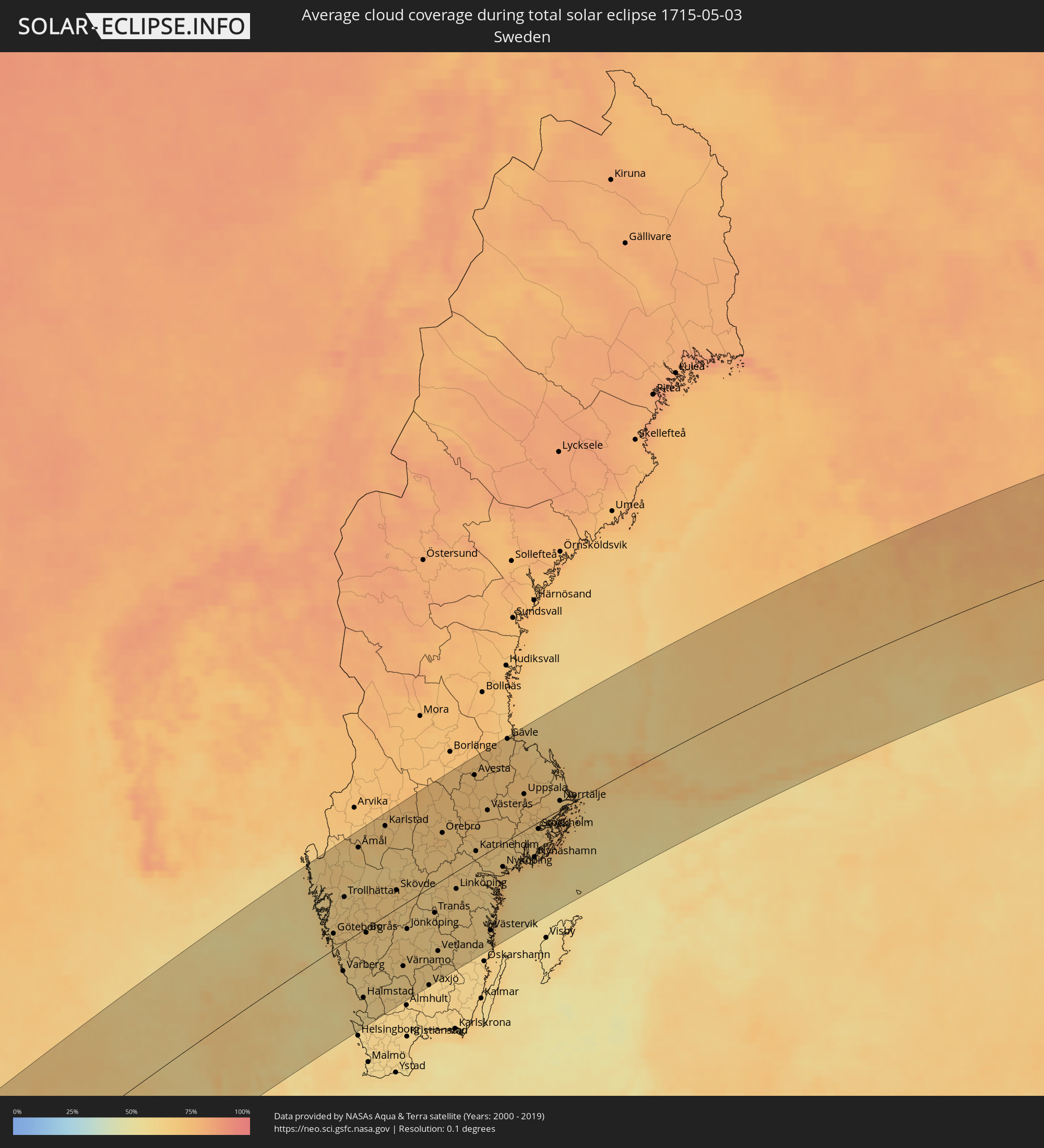 Schweden
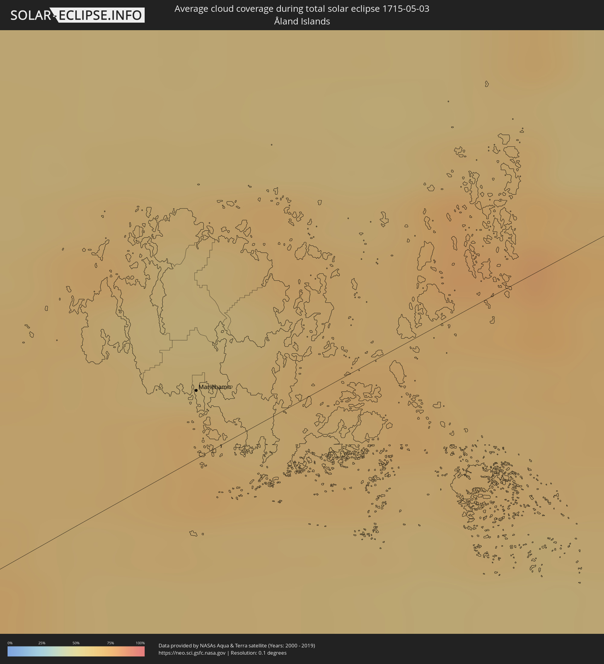 Åland Islands
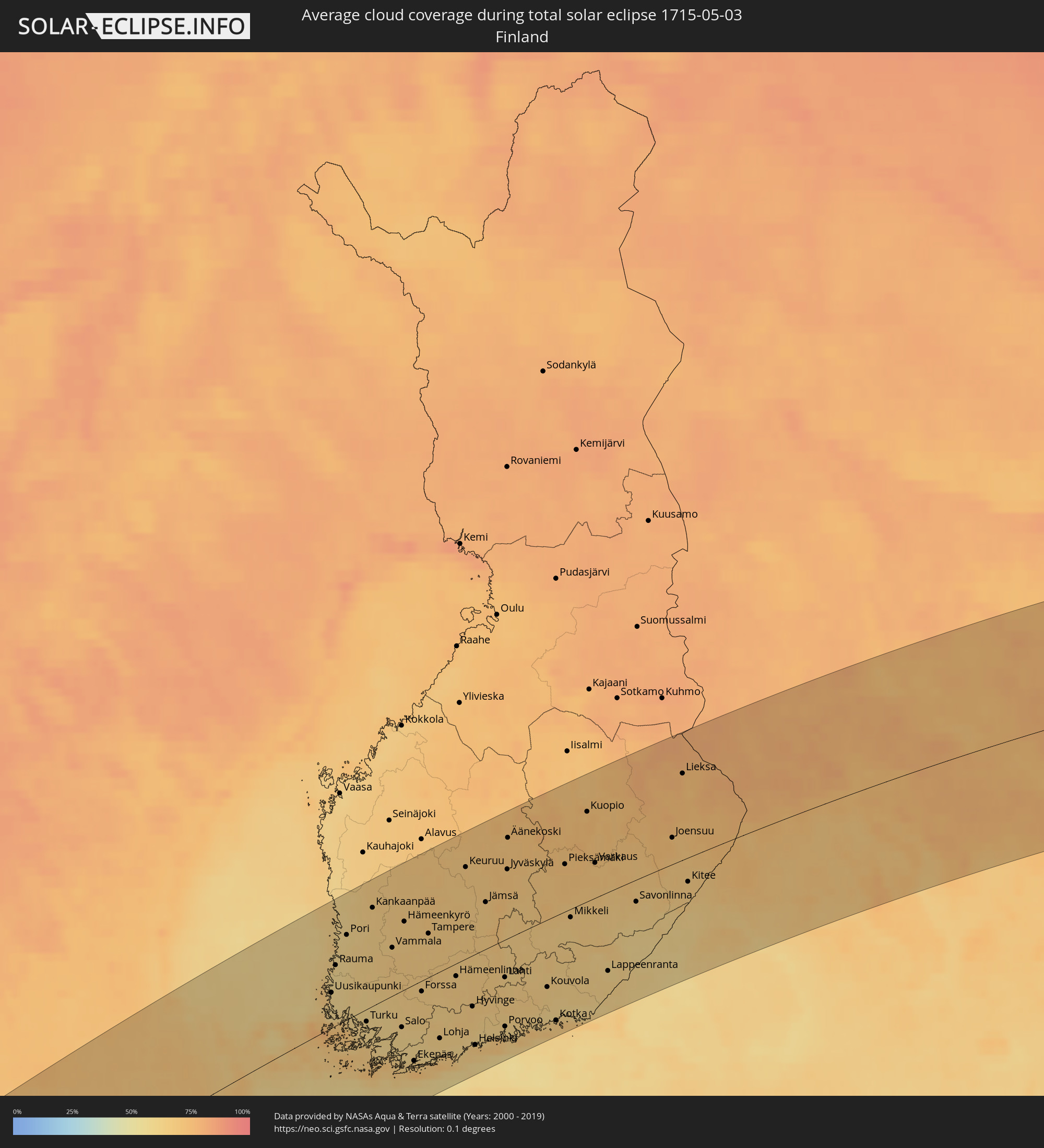 Finnland
Orte im Finsternispfad
Die nachfolgene Tabelle zeigt Städte und Orte mit mehr als 5.000 Einwohnern, die sich im Finsternispfad befinden. Städte mit mehr als 100.000 Einwohnern sind dick gekennzeichnet. Mit einem Klick auf den Ort öffnet sich eine Detailkarte die die Lage des jeweiligen Ortes zusammen mit dem Verlauf der zentralen Finsternis präsentiert.
| Ort | Typ | Dauer der Verfinsterung | Ortszeit bei maximaler Verfinsterung | Entfernung zur Zentrallinie | Ø Bewölkung |
|
Ribeira Grande, Azores
|
total | - | 08:30:46 UTC+00:00 | 17 km | 80% |
|
Horta, Azores
|
total | - | 06:36:16 UTC-01:54 | 12 km | 83% |
|
Madalena, Azores
|
total | - | 06:36:17 UTC-01:54 | 3 km | 83% |
|
Lagoa, Azores
|
total | - | 06:37:09 UTC-01:54 | 34 km | 76% |
|
Angra do Heroísmo, Azores
|
total | - | 06:36:38 UTC-01:54 | 43 km | 83% |
|
Praia da Vitória, Azores
|
total | - | 06:36:47 UTC-01:54 | 45 km | 82% |
|
Plymouth, England
|
total | - | 09:02:15 UTC+00:00 | 25 km | 77% |
|
Swansea, Wales
|
total | - | 09:04:32 UTC+00:00 | 87 km | 76% |
|
Cardiff, Wales
|
total | - | 09:04:54 UTC+00:00 | 44 km | 75% |
|
Bristol, England
|
total | - | 09:05:20 UTC+00:00 | 14 km | 78% |
|
Stoke-on-Trent, England
|
total | - | 09:08:16 UTC+00:00 | 132 km | 81% |
|
Wolverhampton, England
|
total | - | 09:07:37 UTC+00:00 | 95 km | 77% |
|
Birmingham, England
|
total | - | 09:07:38 UTC+00:00 | 77 km | 79% |
|
Coventry, England
|
total | - | 09:07:50 UTC+00:00 | 52 km | 79% |
|
Derby, England
|
total | - | 09:08:42 UTC+00:00 | 96 km | 77% |
|
Sheffield, England
|
total | - | 09:09:28 UTC+00:00 | 137 km | 79% |
|
Southampton, England
|
total | - | 09:05:25 UTC+00:00 | 87 km | 72% |
|
Nottingham, England
|
total | - | 09:09:02 UTC+00:00 | 85 km | 78% |
|
Leicester, England
|
total | - | 09:08:32 UTC+00:00 | 57 km | 79% |
|
Portsmouth, England
|
total | - | 09:05:31 UTC+00:00 | 108 km | 68% |
|
Reading, England
|
total | - | 09:06:43 UTC+00:00 | 55 km | 78% |
|
Northampton, England
|
total | - | 09:08:06 UTC+00:00 | 22 km | 80% |
|
Milton Keynes, England
|
total | - | 09:07:52 UTC+00:00 | 17 km | 81% |
|
Luton, England
|
total | - | 09:07:53 UTC+00:00 | 45 km | 79% |
|
Hull, England
|
total | - | 09:11:01 UTC+00:00 | 122 km | 78% |
|
Sutton, England
|
total | - | 09:07:13 UTC+00:00 | 97 km | 77% |
|
City of London, England
|
total | - | 09:07:34 UTC+00:00 | 87 km | 76% |
|
Bexley, England
|
total | - | 09:07:40 UTC+00:00 | 105 km | 77% |
|
Norwich, England
|
total | - | 09:10:38 UTC+00:00 | 45 km | 81% |
|
Den Burg, North Holland
|
total | - | 09:34:08 UTC+00:19 | 145 km | 70% |
|
Westerland, Schleswig-Holstein
|
total | - | 10:20:51 UTC+01:00 | 109 km | 65% |
|
Sylt-Ost, Schleswig-Holstein
|
total | - | 10:20:54 UTC+01:00 | 117 km | 67% |
|
Esbjerg, South Denmark
|
total | - | 10:21:48 UTC+01:00 | 63 km | 66% |
|
Varde, South Denmark
|
total | - | 10:22:03 UTC+01:00 | 49 km | 65% |
|
Holstebro, Central Jutland
|
total | - | 10:23:13 UTC+01:00 | 23 km | 67% |
|
Thisted, North Denmark
|
total | - | 10:24:07 UTC+01:00 | 67 km | 62% |
|
Niebüll, Schleswig-Holstein
|
total | - | 10:21:13 UTC+01:00 | 138 km | 64% |
|
Herning, Central Jutland
|
total | - | 10:23:16 UTC+01:00 | 25 km | 66% |
|
Leck, Schleswig-Holstein
|
total | - | 10:21:21 UTC+01:00 | 146 km | 65% |
|
Skive, Central Jutland
|
total | - | 10:23:55 UTC+01:00 | 23 km | 65% |
|
Viborg, Central Jutland
|
total | - | 10:24:07 UTC+01:00 | 12 km | 62% |
|
Aabenraa, South Denmark
|
total | - | 10:22:11 UTC+01:00 | 137 km | 63% |
|
Kolding, South Denmark
|
total | - | 10:22:52 UTC+01:00 | 97 km | 63% |
|
Haderslev, South Denmark
|
total | - | 10:22:33 UTC+01:00 | 119 km | 64% |
|
Vejle, South Denmark
|
total | - | 10:23:14 UTC+01:00 | 80 km | 64% |
|
Silkeborg, Central Jutland
|
total | - | 10:23:53 UTC+01:00 | 40 km | 64% |
|
Fredericia, South Denmark
|
total | - | 10:23:16 UTC+01:00 | 100 km | 60% |
|
Horsens, Central Jutland
|
total | - | 10:23:46 UTC+01:00 | 77 km | 62% |
|
Aalborg, North Denmark
|
total | - | 10:25:26 UTC+01:00 | 35 km | 64% |
|
Skanderborg, Central Jutland
|
total | - | 10:24:05 UTC+01:00 | 63 km | 64% |
|
Hjørring, North Denmark
|
total | - | 10:26:04 UTC+01:00 | 68 km | 61% |
|
Randers, Central Jutland
|
total | - | 10:24:46 UTC+01:00 | 31 km | 64% |
|
Århus, Central Jutland
|
total | - | 10:24:32 UTC+01:00 | 62 km | 61% |
|
Odense, South Denmark
|
total | - | 10:23:41 UTC+01:00 | 138 km | 62% |
|
Frederikshavn, North Denmark
|
total | - | 10:26:34 UTC+01:00 | 46 km | 60% |
|
Grenaa, Central Jutland
|
total | - | 10:25:34 UTC+01:00 | 61 km | 60% |
|
Kalundborg, Zealand
|
total | - | 10:24:48 UTC+01:00 | 136 km | 56% |
|
Uddevalla, Västra Götaland
|
total | - | 10:29:07 UTC+01:00 | 85 km | 63% |
|
Göteborg, Västra Götaland
|
total | - | 10:28:21 UTC+01:00 | 27 km | 63% |
|
Trollhättan, Västra Götaland
|
total | - | 10:29:23 UTC+01:00 | 67 km | 63% |
|
Halmstad, Halland
|
total | - | 10:27:57 UTC+01:00 | 102 km | 61% |
|
Borås, Västra Götaland
|
total | - | 10:29:21 UTC+01:00 | 11 km | 66% |
|
Karlstad, Värmland
|
total | - | 10:31:54 UTC+01:00 | 131 km | 67% |
|
Skövde, Västra Götaland
|
total | - | 10:31:05 UTC+01:00 | 28 km | 67% |
|
Jönköping, Jönköping
|
total | - | 10:30:40 UTC+01:00 | 43 km | 63% |
|
Karlskoga, Örebro
|
total | - | 10:32:51 UTC+01:00 | 94 km | 68% |
|
Växjö, Kronoberg
|
total | - | 10:30:17 UTC+01:00 | 146 km | 61% |
|
Motala, Östergötland
|
total | - | 10:32:28 UTC+01:00 | 6 km | 63% |
|
Örebro, Örebro
|
total | - | 10:33:28 UTC+01:00 | 69 km | 69% |
|
Linköping, Östergötland
|
total | - | 10:32:55 UTC+01:00 | 27 km | 65% |
|
Norrköping, Östergötland
|
total | - | 10:33:43 UTC+01:00 | 26 km | 65% |
|
Eskilstuna, Södermanland
|
total | - | 10:34:53 UTC+01:00 | 39 km | 67% |
|
Västerås, Västmanland
|
total | - | 10:35:12 UTC+01:00 | 61 km | 69% |
|
Nyköping, Södermanland
|
total | - | 10:34:45 UTC+01:00 | 37 km | 65% |
|
Gävle, Gävleborg
|
total | - | 10:36:53 UTC+01:00 | 145 km | 69% |
|
Södertälje, Stockholm
|
total | - | 10:35:51 UTC+01:00 | 11 km | 65% |
|
Uppsala, Uppsala
|
total | - | 10:36:33 UTC+01:00 | 53 km | 69% |
|
Upplands Väsby, Stockholm
|
total | - | 10:36:29 UTC+01:00 | 12 km | 67% |
|
Stockholm, Stockholm
|
total | - | 10:36:27 UTC+01:00 | 10 km | 64% |
|
Haninge, Stockholm
|
total | - | 10:36:22 UTC+01:00 | 29 km | 65% |
|
Mariehamn, Mariehamns stad
|
total | - | 11:18:57 UTC+01:39 | 12 km | 70% |
|
Rauma, Satakunta
|
total | - | 11:21:28 UTC+01:39 | 71 km | 58% |
|
Pori, Satakunta
|
total | - | 11:22:02 UTC+01:39 | 99 km | 60% |
|
Turku, Southwest Finland
|
total | - | 11:21:41 UTC+01:39 | 17 km | 60% |
|
Nokia, Pirkanmaa
|
total | - | 11:23:45 UTC+01:39 | 55 km | 66% |
|
Tampere, Pirkanmaa
|
total | - | 11:24:04 UTC+01:39 | 53 km | 65% |
|
Lohja, Uusimaa
|
total | - | 11:23:25 UTC+01:39 | 80 km | 63% |
|
Hämeenlinna, Häme
|
total | - | 11:24:23 UTC+01:39 | 18 km | 65% |
|
Espoo, Uusimaa
|
total | - | 11:24:00 UTC+01:39 | 99 km | 64% |
|
Nurmijärvi, Uusimaa
|
total | - | 11:24:22 UTC+01:39 | 77 km | 65% |
|
Hyvinge, Uusimaa
|
total | - | 11:24:33 UTC+01:39 | 61 km | 65% |
|
Helsinki, Uusimaa
|
total | - | 11:24:17 UTC+01:39 | 109 km | 67% |
|
Vantaa, Uusimaa
|
total | - | 11:24:29 UTC+01:39 | 100 km | 61% |
|
Järvenpää, Uusimaa
|
total | - | 11:24:40 UTC+01:39 | 82 km | 63% |
|
Lahti, Päijänne Tavastia
|
total | - | 11:25:38 UTC+01:39 | 46 km | 64% |
|
Porvoo, Uusimaa
|
total | - | 11:25:14 UTC+01:39 | 105 km | 62% |
|
Jyväskylä, Central Finland
|
total | - | 11:26:31 UTC+01:39 | 81 km | 70% |
|
Kouvola, Kymenlaakso
|
total | - | 11:26:39 UTC+01:39 | 80 km | 64% |
|
Kotka, Kymenlaakso
|
total | - | 11:26:37 UTC+01:39 | 126 km | 66% |
|
Mikkeli, Southern Savonia
|
total | - | 11:27:45 UTC+01:39 | 15 km | 66% |
|
Kuopio, Northern Savo
|
total | - | 11:28:50 UTC+01:39 | 103 km | 73% |
|
Lappeenranta, South Karelia
|
total | - | 11:28:20 UTC+01:39 | 94 km | 61% |
|
Imatra, South Karelia
|
total | - | 11:29:00 UTC+01:39 | 94 km | 61% |
|
Vyborg, Leningradskaya Oblast'
|
total | - | 12:19:13 UTC+02:30 | 142 km | 59% |
|
Joensuu, North Karelia
|
total | - | 11:30:45 UTC+01:39 | 31 km | 72% |
|
Priozërsk, Leningradskaya Oblast'
|
total | - | 12:20:52 UTC+02:30 | 137 km | 57% |
|
Sortavala, Republic of Karelia
|
total | - | 12:21:47 UTC+02:30 | 80 km | 64% |
|
Kondopoga, Republic of Karelia
|
total | - | 12:25:38 UTC+02:30 | 95 km | 71% |
|
Segezha, Republic of Karelia
|
total | - | 12:26:06 UTC+02:30 | 66 km | 77% |
|
Petrozavodsk, Republic of Karelia
|
total | - | 12:25:37 UTC+02:30 | 140 km | 66% |
|
Medvezh’yegorsk, Republic of Karelia
|
total | - | 12:26:01 UTC+02:30 | 26 km | 72% |
|
Onega, Arkhangelskaya
|
total | - | 12:29:45 UTC+02:30 | 23 km | 74% |
|
Severodvinsk, Arkhangelskaya
|
total | - | 12:31:22 UTC+02:30 | 69 km | 72% |
|
Mirnyy, Arkhangelskaya
|
total | - | 12:31:52 UTC+02:30 | 130 km | 73% |
|
Arkhangel’sk, Arkhangelskaya
|
total | - | 12:32:02 UTC+02:30 | 58 km | 72% |
|
Novodvinsk, Arkhangelskaya
|
total | - | 12:32:17 UTC+02:30 | 41 km | 75% |
|
Pechora, Komi Republic
|
total | - | 12:46:06 UTC+02:30 | 14 km | 76% |
|
Usinsk, Komi Republic
|
total | - | 12:45:43 UTC+02:30 | 83 km | 76% |
|
Salekhard, Yamalo-Nenetskiy Avtonomnyy Okrug
|
total | - | 14:23:45 UTC+04:02 | 138 km | 71% |
|
Nadym, Yamalo-Nenetskiy Avtonomnyy Okrug
|
total | - | 14:28:25 UTC+04:02 | 47 km | 72% |
|
Muravlenko, Yamalo-Nenetskiy Avtonomnyy Okrug
|
total | - | 14:31:40 UTC+04:02 | 135 km | 70% |
|
Gubkinskiy, Yamalo-Nenetskiy Avtonomnyy Okrug
|
total | - | 14:31:59 UTC+04:02 | 51 km | 74% |
|
Novyy Urengoy, Yamalo-Nenetskiy Avtonomnyy Okrug
|
total | - | 14:29:58 UTC+04:02 | 132 km | 70% |
|
Tarko-Sale, Yamalo-Nenetskiy Avtonomnyy Okrug
|
total | - | 14:32:02 UTC+04:02 | 16 km | 71% |
|
Bodaybo, Irkutsk
|
total | - | 17:45:02 UTC+06:57 | 120 km | 86% |
|
Neryungri, Sakha
|
total | - | 19:26:46 UTC+08:38 | 41 km | 82% |
|
Tynda, Amur
|
total | - | 19:28:34 UTC+08:38 | 107 km | 76% |