Totale Sonnenfinsternis vom 11.12.1852
| Wochentag: | Samstag |
| Maximale Dauer der Verfinsterung: | 02m05s |
| Maximale Breite des Finsternispfades: | 156 km |
| Saroszyklus: | 120 |
| Bedeckungsgrad: | 100% |
| Magnitude: | 1.0237 |
| Gamma: | 0.8551 |
Wo kann man die Sonnenfinsternis vom 11.12.1852 sehen?
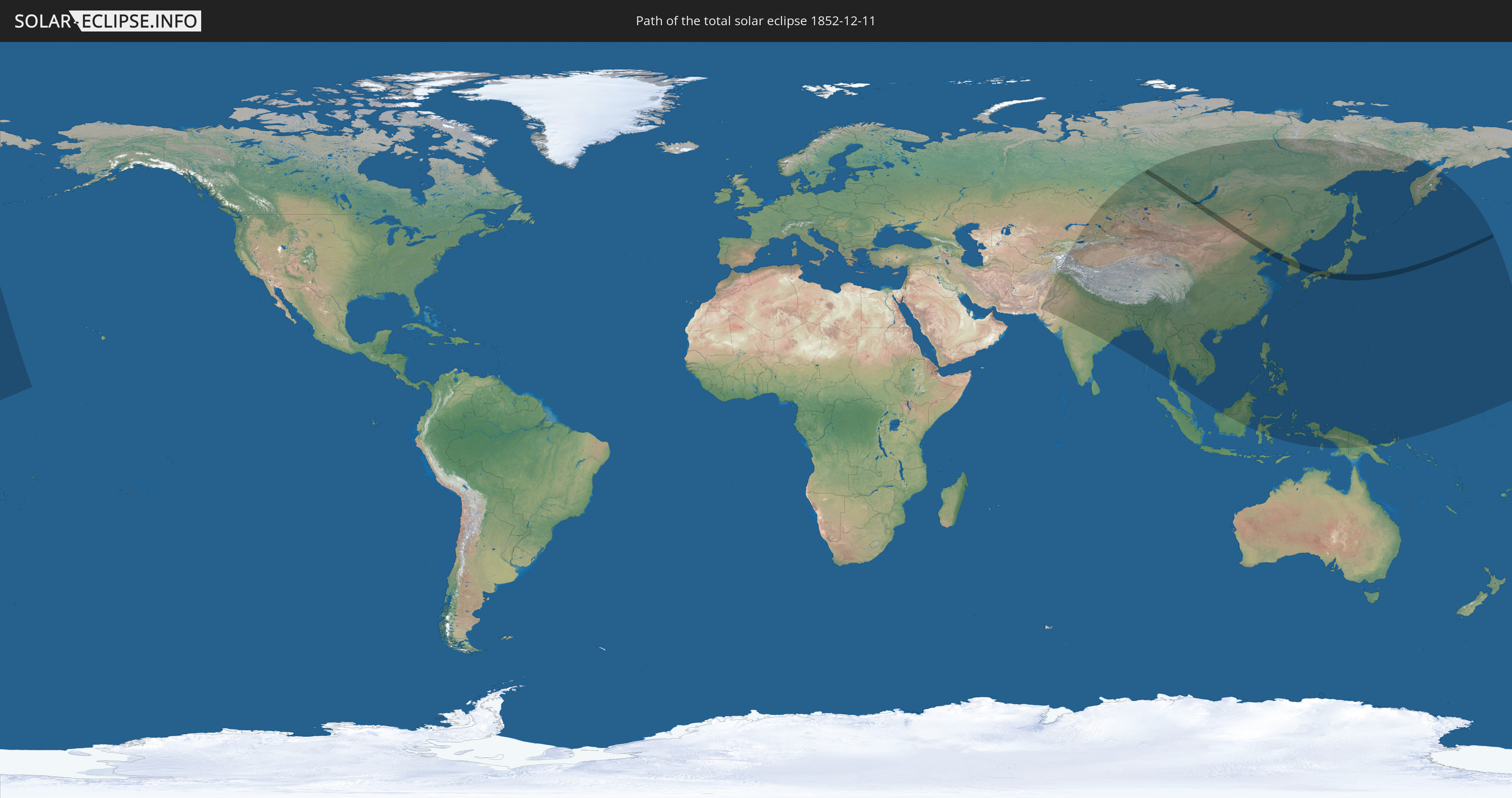
Die Sonnenfinsternis am 11.12.1852 kann man in 35 Ländern als partielle Sonnenfinsternis beobachten.
Der Finsternispfad verläuft durch 6 Länder. Nur in diesen Ländern ist sie als totale Sonnenfinsternis zu sehen.
In den folgenden Ländern ist die Sonnenfinsternis total zu sehen
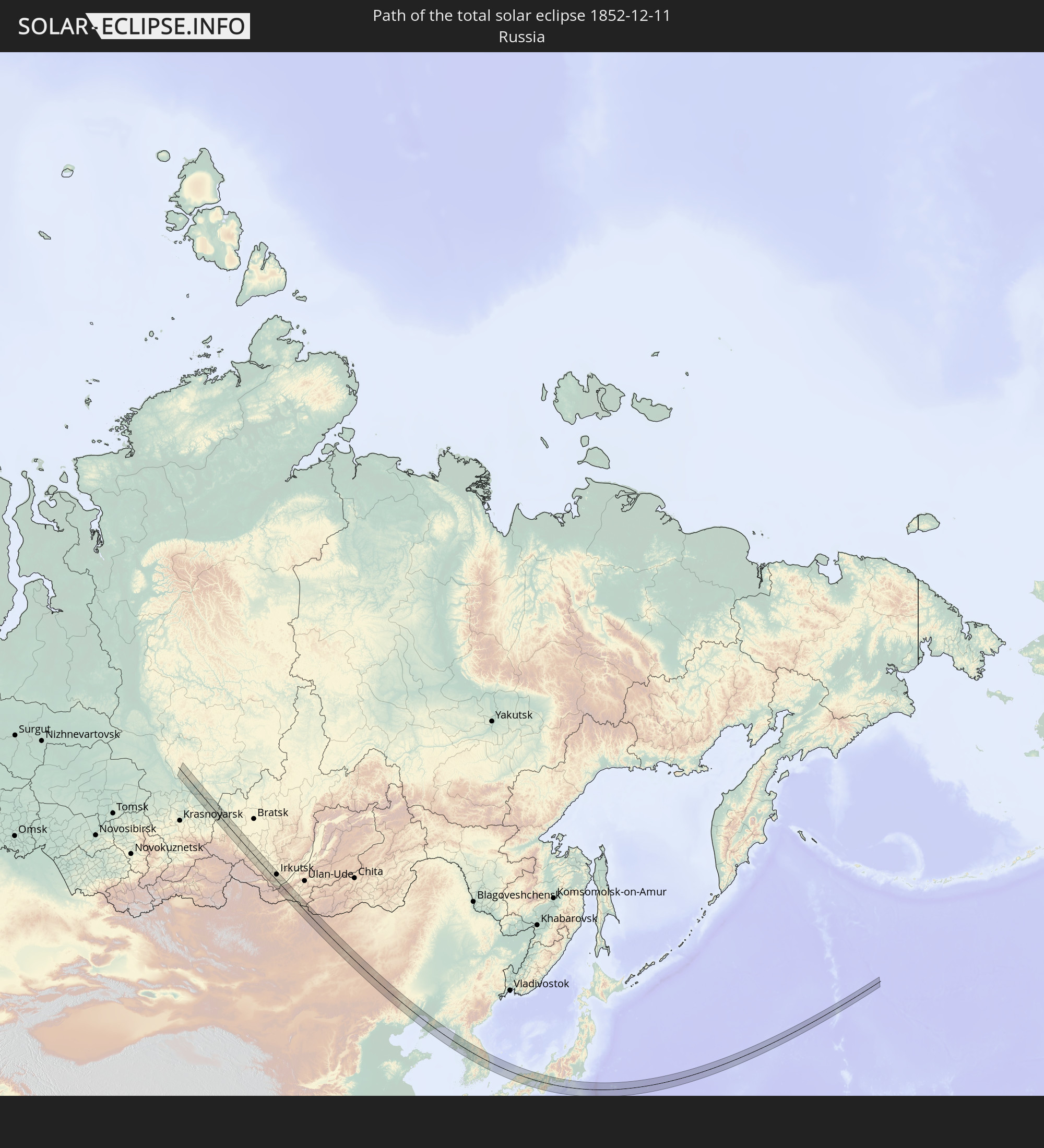 Russland
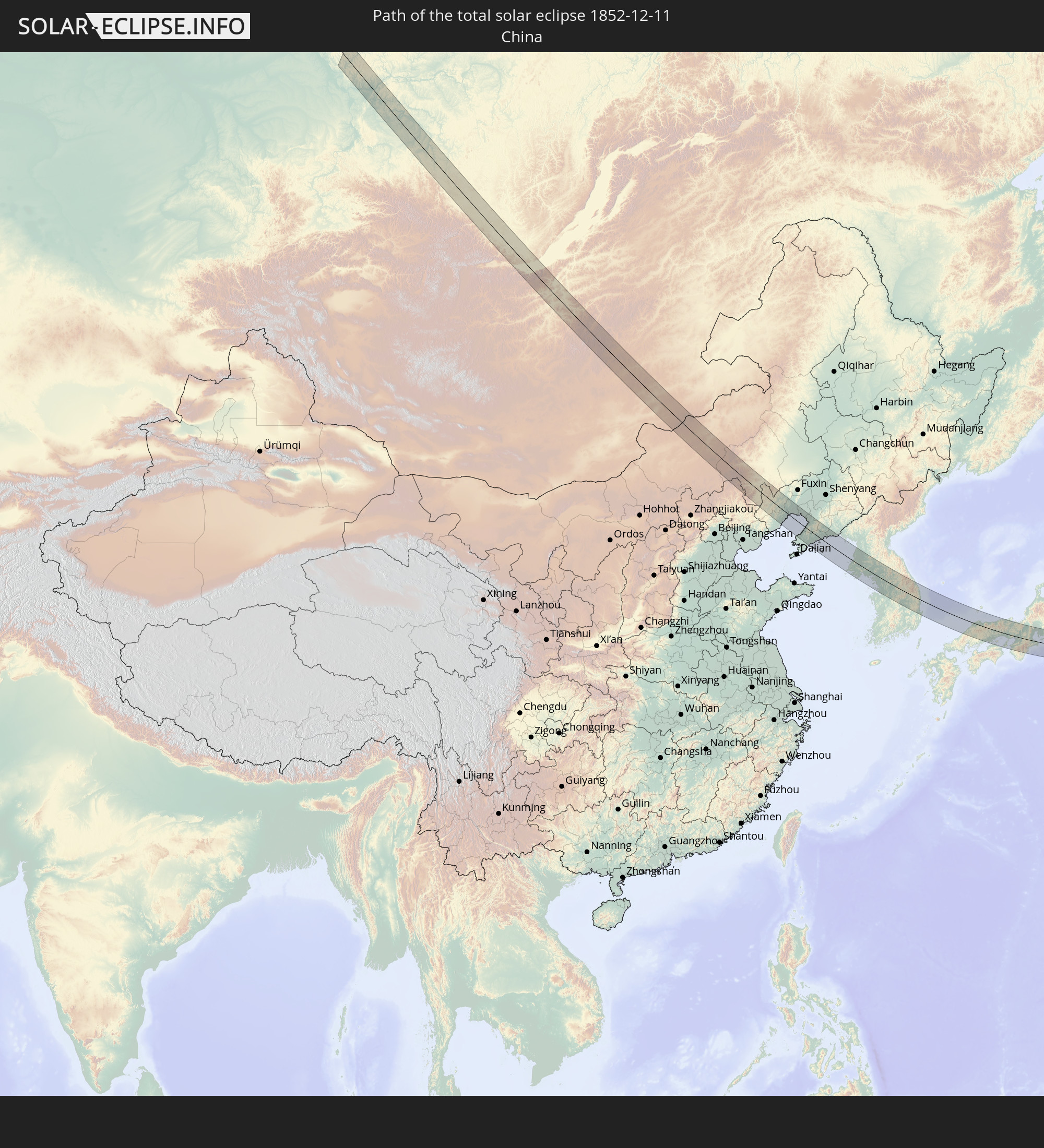 Volksrepublik China
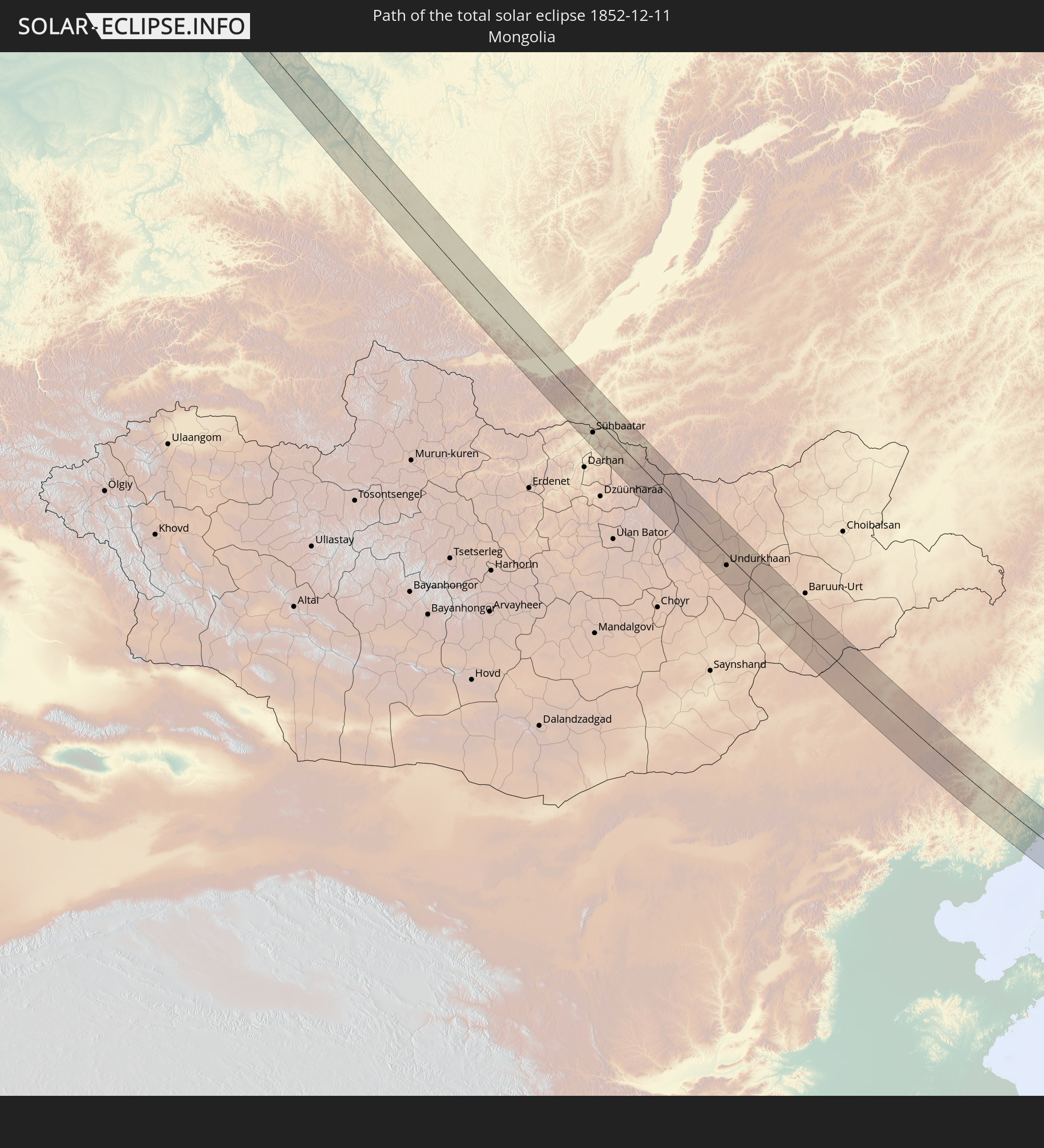 Mongolei
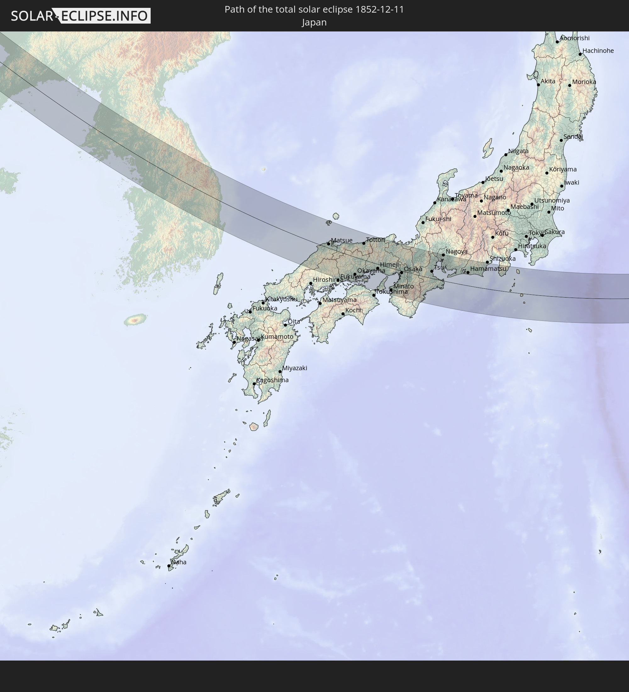 Japan
Japan
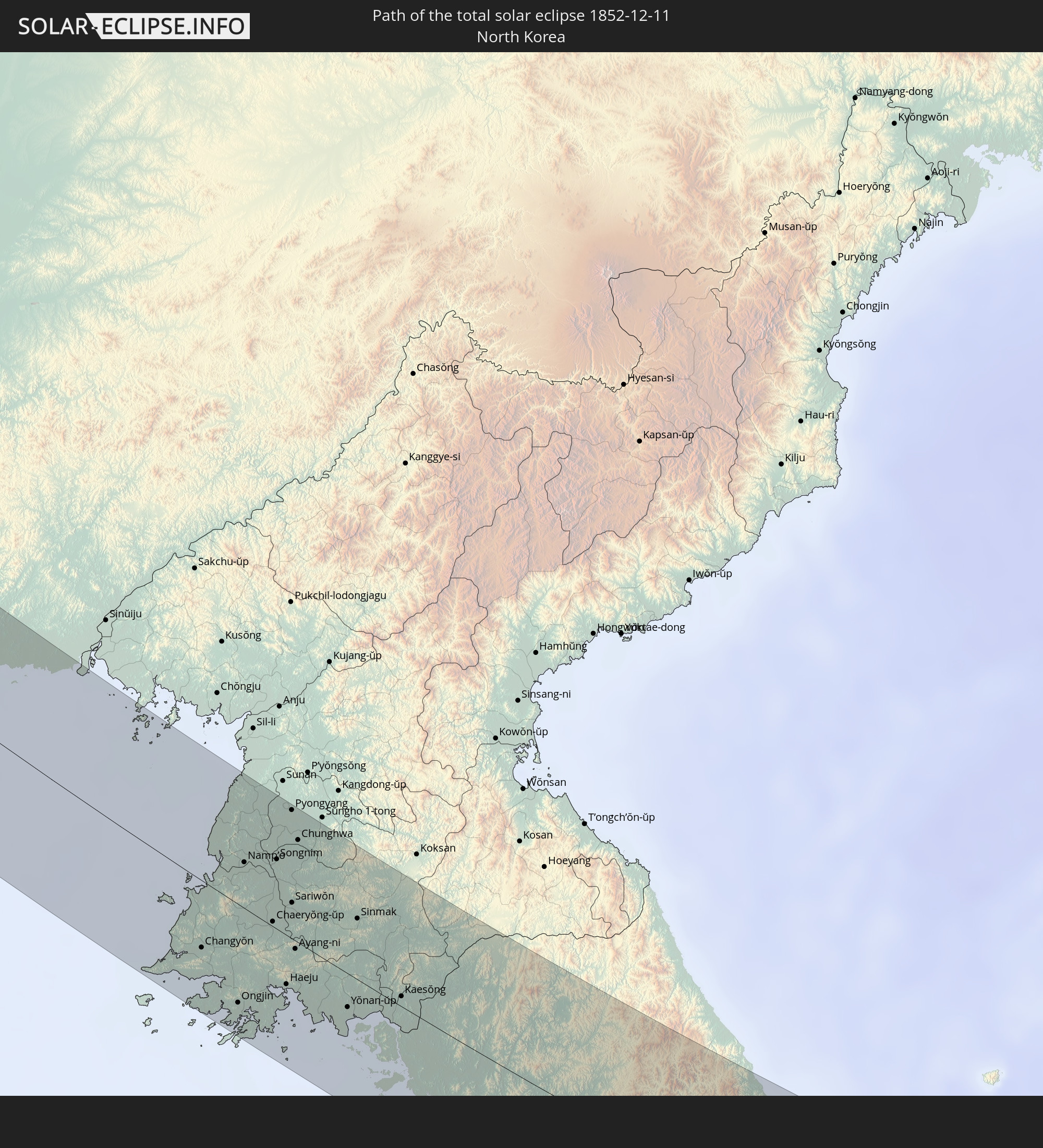 Nordkorea
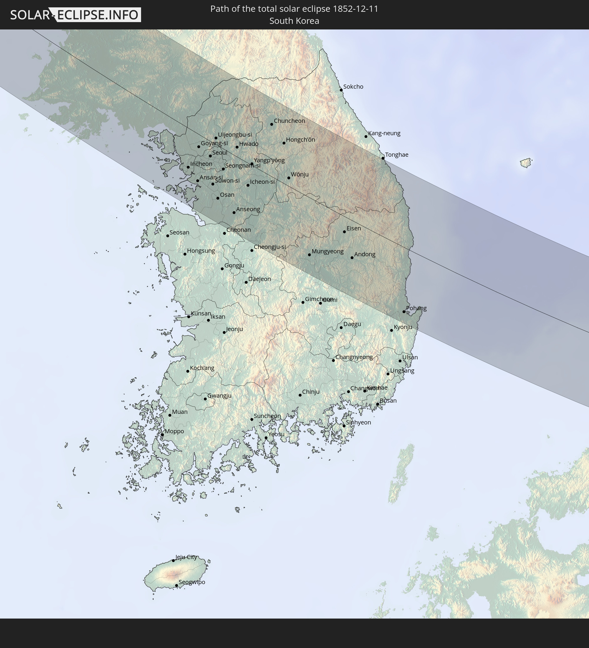 Südkorea
In den folgenden Ländern ist die Sonnenfinsternis partiell zu sehen
 Russland
 United States Minor Outlying Islands
 Kiribati
 Kasachstan
 Afghanistan
 Pakistan
 Tadschikistan
 Indien
 Kirgisistan
 Volksrepublik China
 Nepal
Nepal
 Mongolei
 Bangladesch
 Bhutan
 Myanmar
 Indonesien
 Thailand
 Malaysia
 Laos
Laos
 Vietnam
 Kambodscha
 Macau
Macau
 Hongkong
 Brunei
 Taiwan
 Philippinen
 Japan
Japan
 Nordkorea
 Südkorea
 Palau
Palau
 Föderierte Staaten von Mikronesien
 Papua-Neuguinea
 Guam
Guam
 Nördliche Marianen
 Marshallinseln
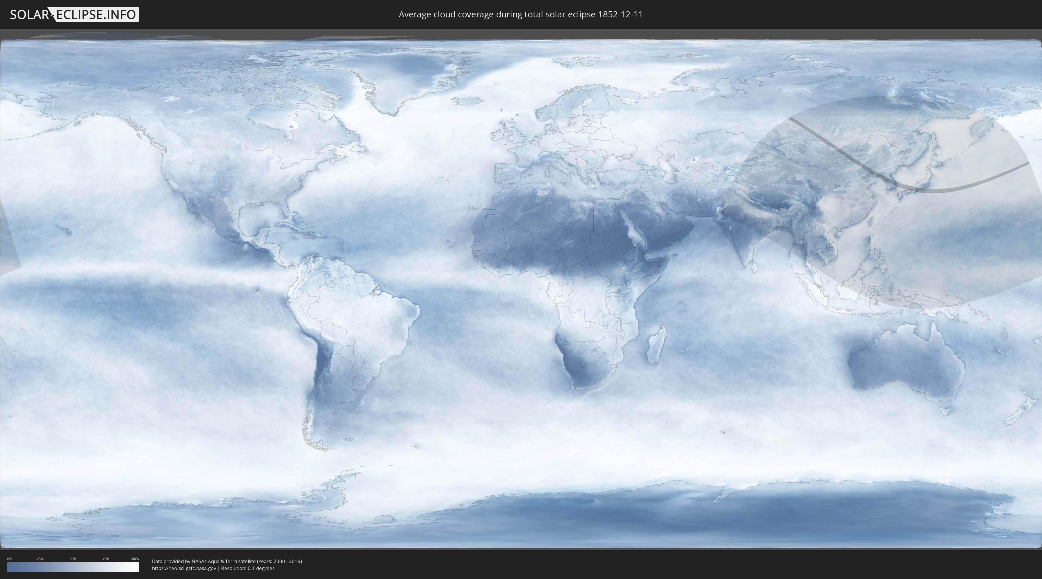
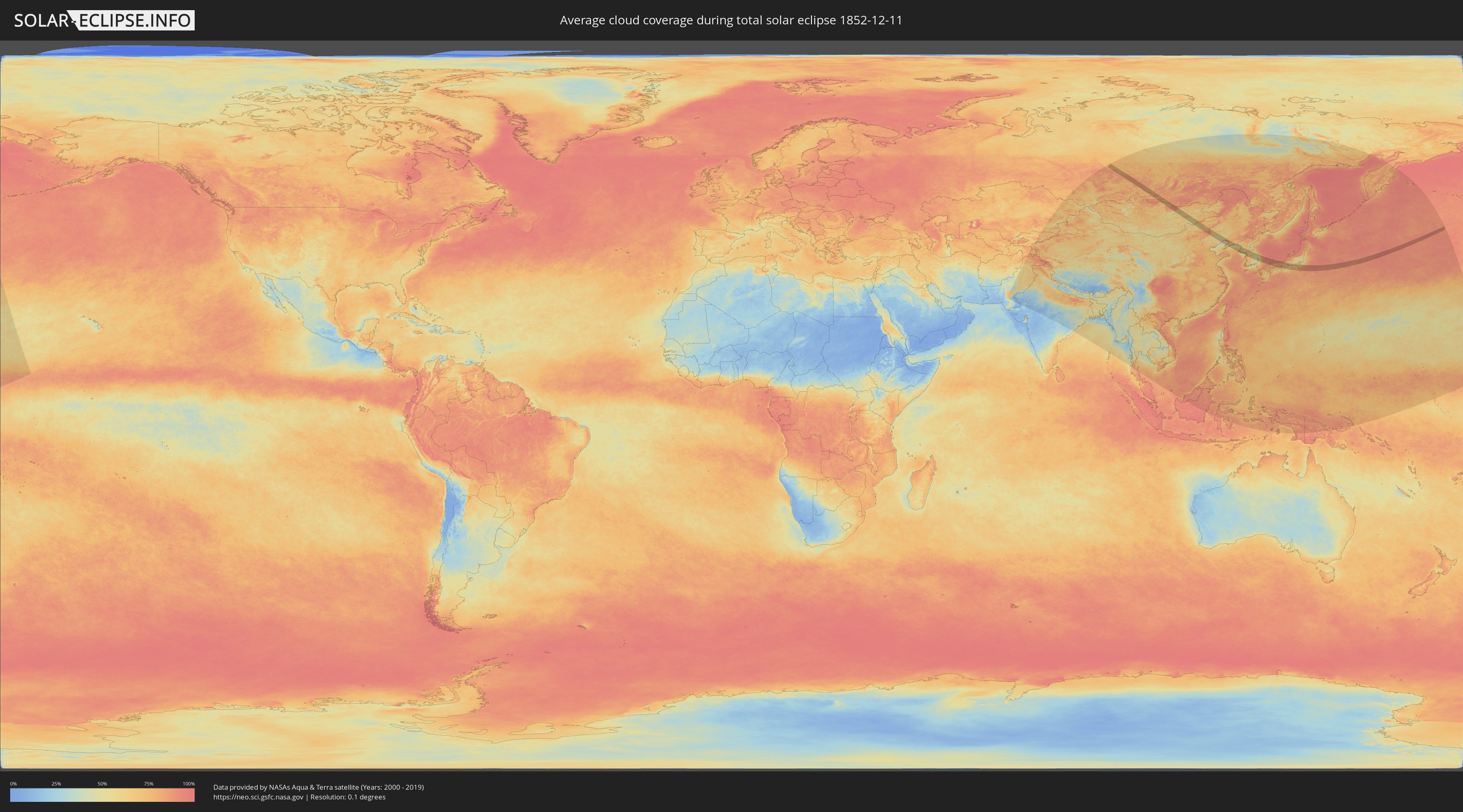
Wie wird das Wetter während der totalen Sonnenfinsternis am 11.12.1852?
Wo ist der beste Ort, um die totale Sonnenfinsternis vom 11.12.1852 zu beobachten?
Die folgenden Karten zeigen die durchschnittliche Bewölkung für den Tag, an dem die totale Sonnenfinsternis
stattfindet. Mit Hilfe der Karten lässt sich der Ort entlang des Finsternispfades eingrenzen,
der die besten Aussichen auf einen klaren wolkenfreien Himmel bietet.
Trotzdem muss man immer lokale Gegenenheiten beachten und sollte sich genau über das Wetter an seinem
gewählten Beobachtungsort informieren.
Die Daten stammen von den beiden NASA-Satelliten
AQUA und TERRA
und wurden über einen Zeitraum von 19 Jahren (2000 - 2019) gemittelt.
Detaillierte Länderkarten
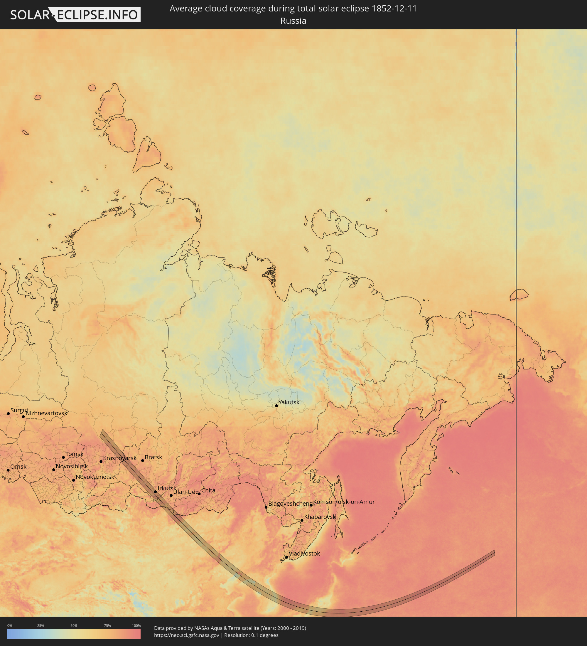 Russland
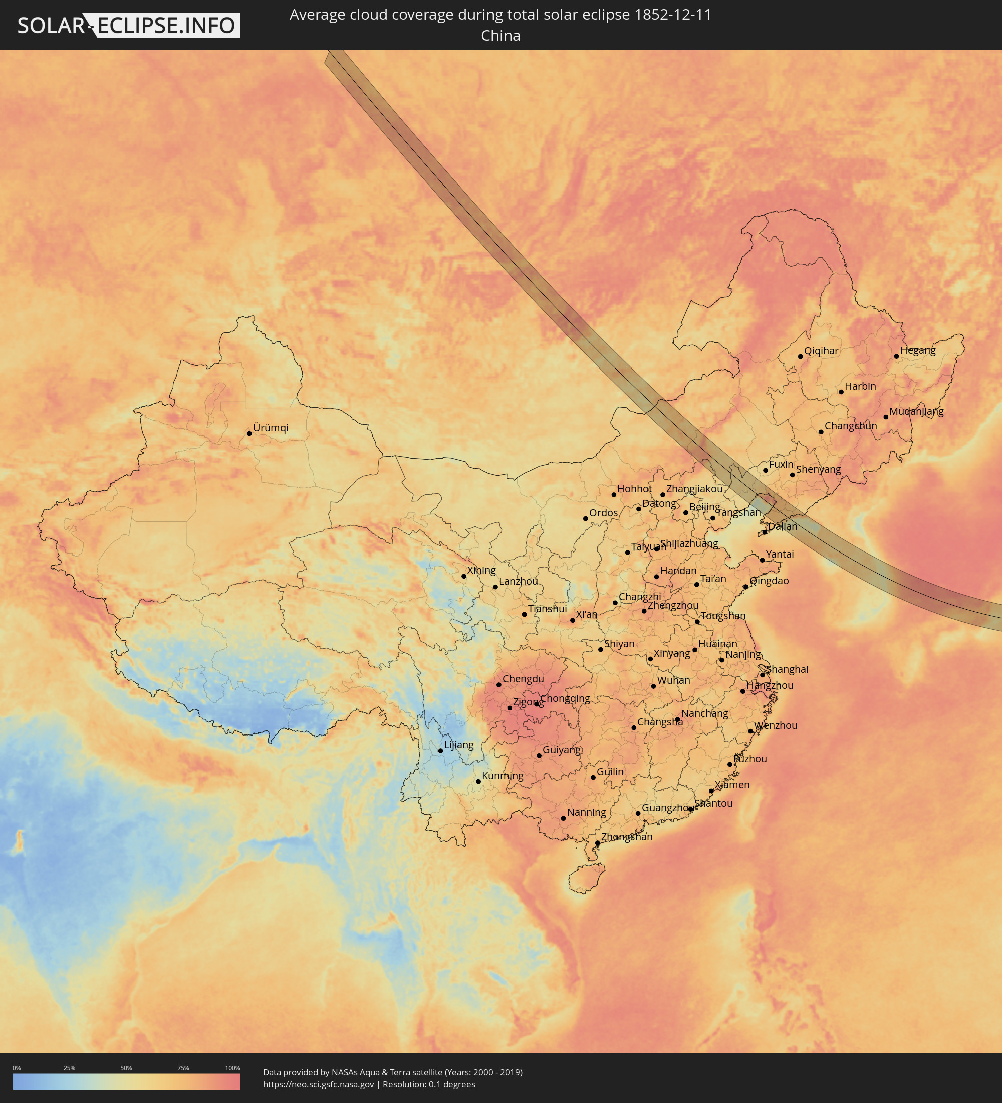 Volksrepublik China
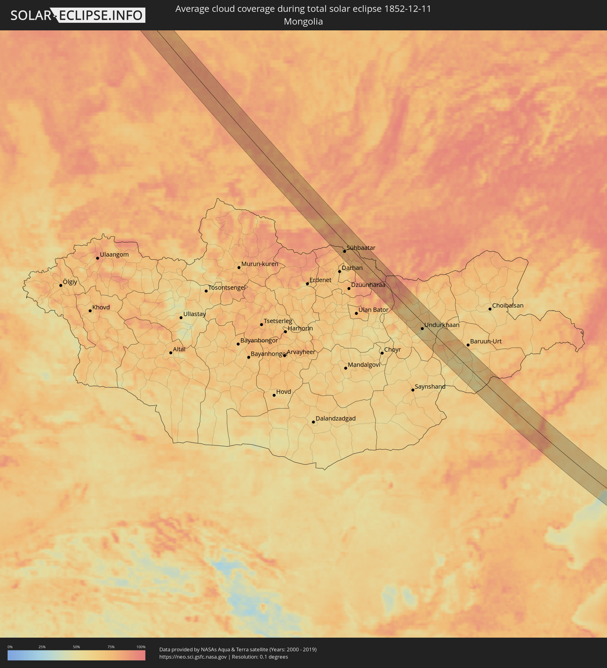 Mongolei
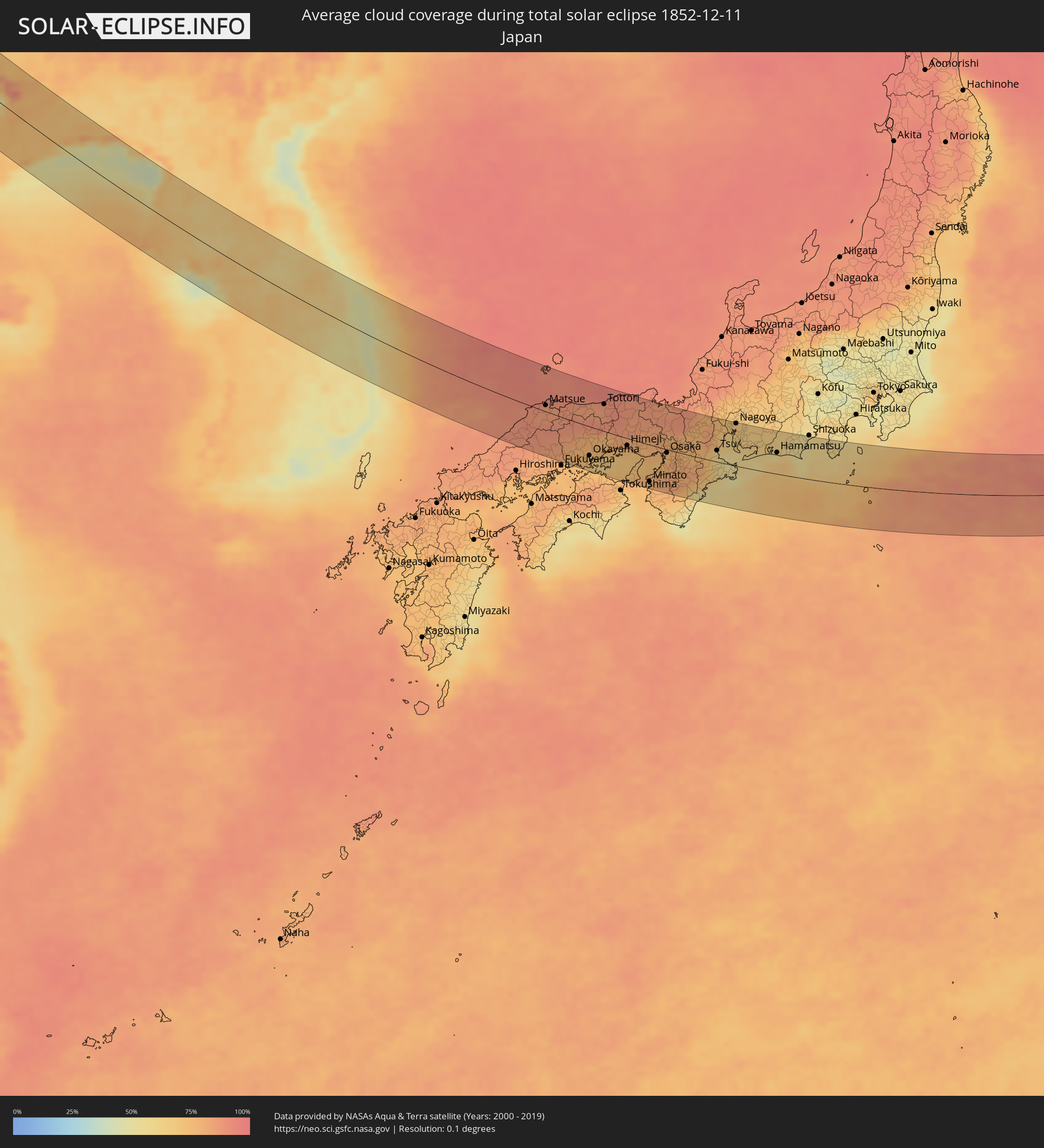 Japan
Japan
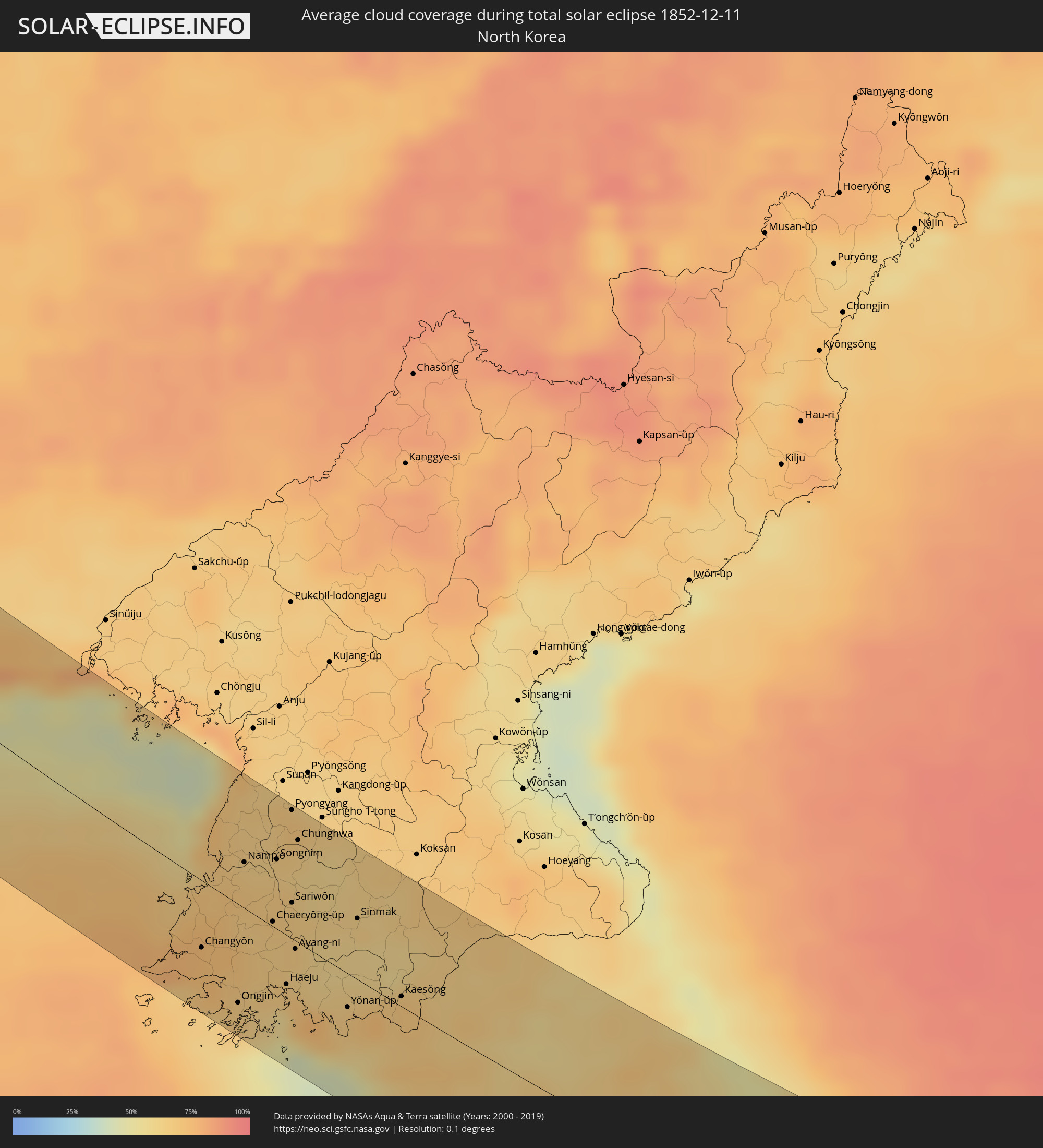 Nordkorea
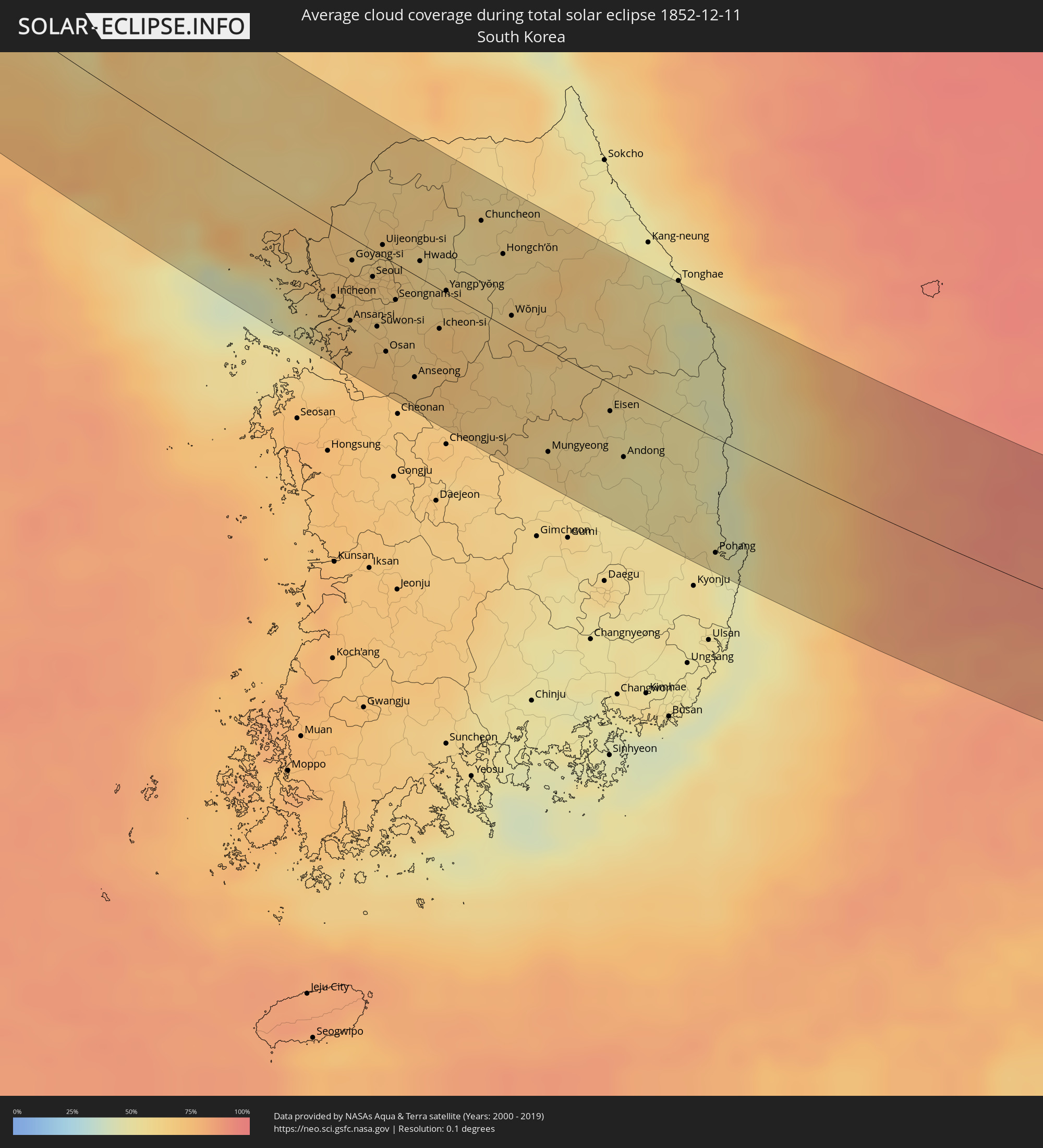 Südkorea
Orte im Finsternispfad
Die nachfolgene Tabelle zeigt Städte und Orte mit mehr als 5.000 Einwohnern, die sich im Finsternispfad befinden. Städte mit mehr als 100.000 Einwohnern sind dick gekennzeichnet. Mit einem Klick auf den Ort öffnet sich eine Detailkarte die die Lage des jeweiligen Ortes zusammen mit dem Verlauf der zentralen Finsternis präsentiert.
| Ort | Typ | Dauer der Verfinsterung | Ortszeit bei maximaler Verfinsterung | Entfernung zur Zentrallinie | Ø Bewölkung |
|
Motygino, Krasnoyarskiy
|
total | - | 08:58:26 UTC+06:11 | 3 km | 84% |
|
Aban, Krasnoyarskiy
|
total | - | 08:57:57 UTC+06:11 | 43 km | 85% |
|
Nizhnyaya Poyma, Krasnoyarskiy
|
total | - | 08:58:23 UTC+06:11 | 27 km | 84% |
|
Yurty, Irkutsk
|
total | - | 09:44:16 UTC+06:57 | 16 km | 84% |
|
Biryusinsk, Irkutsk
|
total | - | 09:44:21 UTC+06:57 | 13 km | 85% |
|
Tayshet, Irkutsk
|
total | - | 09:44:29 UTC+06:57 | 7 km | 85% |
|
Alzamay, Irkutsk
|
total | - | 09:44:42 UTC+06:57 | 3 km | 83% |
|
Nizhneudinsk, Irkutsk
|
total | - | 09:44:26 UTC+06:57 | 34 km | 82% |
|
Tulun, Irkutsk
|
total | - | 09:45:33 UTC+06:57 | 16 km | 82% |
|
Kuytun, Irkutsk
|
total | - | 09:46:15 UTC+06:57 | 45 km | 84% |
|
Zima, Irkutsk
|
total | - | 09:46:26 UTC+06:57 | 40 km | 83% |
|
Zalari, Irkutsk
|
total | - | 09:46:36 UTC+06:57 | 36 km | 83% |
|
Kutulik, Irkutsk
|
total | - | 09:46:43 UTC+06:57 | 35 km | 78% |
|
Cheremkhovo, Irkutsk
|
total | - | 09:46:52 UTC+06:57 | 34 km | 81% |
|
Mishelevka, Irkutsk
|
total | - | 09:46:45 UTC+06:57 | 17 km | 77% |
|
Svirsk, Irkutsk
|
total | - | 09:47:05 UTC+06:57 | 42 km | 78% |
|
Tayturka, Irkutsk
|
total | - | 09:47:03 UTC+06:57 | 33 km | 82% |
|
Sredniy, Irkutsk
|
total | - | 09:47:06 UTC+06:57 | 36 km | 82% |
|
Usol’ye-Sibirskoye, Irkutsk
|
total | - | 09:47:09 UTC+06:57 | 33 km | 81% |
|
Slyudyanka, Irkutsk
|
total | - | 09:46:26 UTC+06:57 | 46 km | 83% |
|
Angarsk, Irkutsk
|
total | - | 09:47:15 UTC+06:57 | 29 km | 81% |
|
Meget, Irkutsk
|
total | - | 09:47:20 UTC+06:57 | 28 km | 79% |
|
Shelekhov, Irkutsk
|
total | - | 09:47:15 UTC+06:57 | 16 km | 82% |
|
Baykal’sk, Irkutsk
|
total | - | 09:46:48 UTC+06:57 | 35 km | 73% |
|
Markova, Irkutsk
|
total | - | 09:47:22 UTC+06:57 | 21 km | 82% |
|
Irkutsk, Irkutsk
|
total | - | 09:47:31 UTC+06:57 | 32 km | 82% |
|
Vydreno, Respublika Buryatiya
|
total | - | 09:47:19 UTC+06:57 | 13 km | 80% |
|
Rechka-Vydrino, Respublika Buryatiya
|
total | - | 09:47:33 UTC+06:57 | 1 km | 75% |
|
Petropavlovka, Respublika Buryatiya
|
total | - | 09:47:31 UTC+06:57 | 43 km | 83% |
|
Sühbaatar, Selenge
|
total | - | 09:58:45 UTC+07:07 | 27 km | 77% |
|
Kyakhta, Respublika Buryatiya
|
total | - | 09:48:40 UTC+06:57 | 4 km | 73% |
|
Undurkhaan, Hentiy
|
total | - | 10:02:55 UTC+07:07 | 19 km | 50% |
|
Xilin Hot, Inner Mongolia
|
total | - | 11:02:31 UTC+08:00 | 2 km | 82% |
|
Mujiayingzi, Inner Mongolia
|
total | - | 11:07:03 UTC+08:00 | 11 km | 63% |
|
Chifeng, Inner Mongolia
|
total | - | 11:07:22 UTC+08:00 | 12 km | 63% |
|
Pingzhuang, Inner Mongolia
|
total | - | 11:07:57 UTC+08:00 | 9 km | 61% |
|
Lingyuan, Liaoning
|
total | - | 11:08:09 UTC+08:00 | 54 km | 58% |
|
Yebaishou, Liaoning
|
total | - | 11:08:35 UTC+08:00 | 27 km | 56% |
|
Chaoyang, Liaoning
|
total | - | 11:10:06 UTC+08:00 | 30 km | 57% |
|
Xingcheng, Liaoning
|
total | - | 11:10:38 UTC+08:00 | 39 km | 62% |
|
Nanpiao, Liaoning
|
total | - | 11:10:40 UTC+08:00 | 4 km | 63% |
|
Lianshan, Liaoning
|
total | - | 11:10:53 UTC+08:00 | 19 km | 59% |
|
Jinzhou, Liaoning
|
total | - | 11:11:24 UTC+08:00 | 26 km | 63% |
|
Linghai, Liaoning
|
total | - | 11:11:49 UTC+08:00 | 42 km | 65% |
|
Wafangdian, Liaoning
|
total | - | 11:13:14 UTC+08:00 | 62 km | 74% |
|
Yingkou, Liaoning
|
total | - | 11:13:31 UTC+08:00 | 43 km | 85% |
|
Dashiqiao, Liaoning
|
total | - | 11:14:03 UTC+08:00 | 54 km | 76% |
|
Zhuanghe, Liaoning
|
total | - | 11:15:10 UTC+08:00 | 5 km | 68% |
|
Xiuyan, Liaoning
|
total | - | 11:15:37 UTC+08:00 | 62 km | 72% |
|
Changyŏn, Hwanghae-namdo
|
total | - | 11:42:47 UTC+08:23 | 36 km | 75% |
|
Ongjin, Hwanghae-namdo
|
total | - | 11:43:26 UTC+08:23 | 53 km | 67% |
|
Namp’o, P'yŏngan-namdo
|
total | - | 11:43:18 UTC+08:23 | 24 km | 66% |
|
Yonggang-ŭp, P'yŏngan-namdo
|
total | - | 11:43:18 UTC+08:23 | 36 km | 66% |
|
Anak, Hwanghae-bukto
|
total | - | 11:43:33 UTC+08:23 | 7 km | 66% |
|
Pyŏksŏng-ŭp, Hwanghae-namdo
|
total | - | 11:43:49 UTC+08:23 | 33 km | 66% |
|
Chaeryŏng-ŭp, Hwanghae-namdo
|
total | - | 11:43:50 UTC+08:23 | 3 km | 66% |
|
Songnim, Hwanghae-bukto
|
total | - | 11:43:47 UTC+08:23 | 37 km | 64% |
|
Haeju, Hwanghae-namdo
|
total | - | 11:44:09 UTC+08:23 | 26 km | 66% |
|
Pyongyang, Pyongyang
|
total | - | 11:43:56 UTC+08:23 | 68 km | 69% |
|
Sariwŏn, Hwanghae-bukto
|
total | - | 11:44:06 UTC+08:23 | 19 km | 66% |
|
Hwangju-ŭp, Hwanghae-bukto
|
total | - | 11:44:05 UTC+08:23 | 36 km | 63% |
|
Ayang-ni, Hwanghae-namdo
|
total | - | 11:44:14 UTC+08:23 | 4 km | 63% |
|
Hŭkkyo-ri, Hwanghae-bukto
|
total | - | 11:44:05 UTC+08:23 | 48 km | 64% |
|
Chunghwa, Pyongyang
|
total | - | 11:44:05 UTC+08:23 | 55 km | 66% |
|
Yŏnan-ŭp, Hwanghae-namdo
|
total | - | 11:45:08 UTC+08:23 | 18 km | 67% |
|
Sinmak, Hwanghae-bukto
|
total | - | 11:45:08 UTC+08:23 | 33 km | 62% |
|
Kaesŏng, Hwanghae-namdo
|
total | - | 11:45:57 UTC+08:23 | 6 km | 69% |
|
Incheon, Incheon
|
total | - | 11:51:20 UTC+08:27 | 37 km | 67% |
|
Munsan, Gyeonggi-do
|
total | - | 11:51:21 UTC+08:27 | 5 km | 66% |
|
Ansan-si, Gyeonggi-do
|
total | - | 11:51:38 UTC+08:27 | 44 km | 69% |
|
Goyang-si, Gyeonggi-do
|
total | - | 11:51:32 UTC+08:27 | 12 km | 68% |
|
Kwangmyŏng, Gyeonggi-do
|
total | - | 11:51:40 UTC+08:27 | 28 km | 67% |
|
Seoul, Seoul
|
total | - | 11:51:52 UTC+08:27 | 14 km | 68% |
|
Suwon-si, Gyeonggi-do
|
total | - | 11:52:03 UTC+08:27 | 39 km | 67% |
|
Uijeongbu-si, Gyeonggi-do
|
total | - | 11:51:57 UTC+08:27 | 6 km | 66% |
|
Yangju, Gyeonggi-do
|
total | - | 11:51:57 UTC+08:27 | 15 km | 63% |
|
Osan, Gyeonggi-do
|
total | - | 11:52:14 UTC+08:27 | 50 km | 68% |
|
Seongnam-si, Gyeonggi-do
|
total | - | 11:52:16 UTC+08:27 | 19 km | 65% |
|
Guri-si, Gyeonggi-do
|
total | - | 11:52:13 UTC+08:27 | 4 km | 68% |
|
Hanam, Gyeonggi-do
|
total | - | 11:52:22 UTC+08:27 | 6 km | 64% |
|
Namyangju, Gyeonggi-do
|
total | - | 11:52:21 UTC+08:27 | 3 km | 64% |
|
Wabu, Gyeonggi-do
|
total | - | 11:52:23 UTC+08:27 | 1 km | 64% |
|
Gwangju, Gyeonggi-do
|
total | - | 11:52:32 UTC+08:27 | 17 km | 65% |
|
Anseong, Gyeonggi-do
|
total | - | 11:52:43 UTC+08:27 | 55 km | 68% |
|
Hwado, Gyeonggi-do
|
total | - | 11:52:33 UTC+08:27 | 9 km | 61% |
|
Icheon-si, Gyeonggi-do
|
total | - | 11:52:59 UTC+08:27 | 21 km | 70% |
|
Chinch'ŏn, Chungcheongbuk-do
|
total | - | 11:53:09 UTC+08:27 | 62 km | 68% |
|
Yangp'yŏng, Gyeonggi-do
|
total | - | 11:53:01 UTC+08:27 | 1 km | 64% |
|
Pubal, Gyeonggi-do
|
total | - | 11:53:07 UTC+08:27 | 17 km | 71% |
|
Gapyeong, Gyeonggi-do
|
total | - | 11:52:55 UTC+08:27 | 35 km | 57% |
|
Chuncheon, Gangwon-do
|
total | - | 11:53:23 UTC+08:27 | 49 km | 60% |
|
Koesan, Chungcheongbuk-do
|
total | - | 11:53:57 UTC+08:27 | 51 km | 63% |
|
Hongch’ŏn, Gangwon-do
|
total | - | 11:53:47 UTC+08:27 | 38 km | 60% |
|
Wŏnju, Gangwon-do
|
total | - | 11:54:03 UTC+08:27 | 8 km | 65% |
|
Mungyeong, Gyeongsangbuk-do
|
total | - | 11:54:56 UTC+08:27 | 55 km | 63% |
|
Eisen, Gyeongsangbuk-do
|
total | - | 11:55:47 UTC+08:27 | 15 km | 55% |
|
Andong, Gyeongsangbuk-do
|
total | - | 11:56:06 UTC+08:27 | 36 km | 53% |
|
T’aebaek, Gangwon-do
|
total | - | 11:56:24 UTC+08:27 | 35 km | 55% |
|
Santyoku, Gangwon-do
|
total | - | 11:56:41 UTC+08:27 | 68 km | 45% |
|
Yeonil, Gyeongsangbuk-do
|
total | - | 11:57:46 UTC+08:27 | 68 km | 51% |
|
Pohang, Gyeongsangbuk-do
|
total | - | 11:57:47 UTC+08:27 | 64 km | 51% |
|
Matsue, Shimane
|
total | - | 12:38:34 UTC+09:00 | 11 km | 86% |
|
Yonago, Tottori
|
total | - | 12:39:14 UTC+09:00 | 14 km | 87% |
|
Kurashiki, Okayama
|
total | - | 12:40:47 UTC+09:00 | 63 km | 74% |
|
Okayama, Okayama
|
total | - | 12:41:07 UTC+09:00 | 51 km | 73% |
|
Tsuyama, Okayama
|
total | - | 12:41:01 UTC+09:00 | 7 km | 82% |
|
Tottori, Tottori
|
total | - | 12:41:15 UTC+09:00 | 47 km | 86% |
|
Himeji, Hyōgo
|
total | - | 12:42:47 UTC+09:00 | 13 km | 74% |
|
Akashi, Hyōgo
|
total | - | 12:43:33 UTC+09:00 | 25 km | 72% |
|
Minato, Wakayama
|
total | - | 12:44:14 UTC+09:00 | 66 km | 77% |
|
Kobe, Hyōgo
|
total | - | 12:43:58 UTC+09:00 | 14 km | 76% |
|
Sandachō, Hyōgo
|
total | - | 12:43:56 UTC+09:00 | 8 km | 78% |
|
Maizuru, Kyoto
|
total | - | 12:43:47 UTC+09:00 | 71 km | 85% |
|
Takarazuka, Hyōgo
|
total | - | 12:44:18 UTC+09:00 | 2 km | 79% |
|
Kishiwada, Ōsaka
|
total | - | 12:44:33 UTC+09:00 | 34 km | 77% |
|
Osaka, Ōsaka
|
total | - | 12:44:42 UTC+09:00 | 6 km | 74% |
|
Kameoka, Kyoto
|
total | - | 12:44:40 UTC+09:00 | 29 km | 78% |
|
Tondabayashichō, Ōsaka
|
total | - | 12:45:04 UTC+09:00 | 25 km | 79% |
|
Hirakata, Ōsaka
|
total | - | 12:44:57 UTC+09:00 | 10 km | 77% |
|
Kyoto, Kyoto
|
total | - | 12:45:03 UTC+09:00 | 35 km | 79% |
|
Kashihara-shi, Nara
|
total | - | 12:45:30 UTC+09:00 | 19 km | 79% |
|
Uji, Kyoto
|
total | - | 12:45:15 UTC+09:00 | 22 km | 77% |
|
Nara-shi, Nara
|
total | - | 12:45:24 UTC+09:00 | 0 km | 76% |
|
Kusatsu, Shiga Prefecture
|
total | - | 12:45:32 UTC+09:00 | 39 km | 77% |
|
Hikone, Shiga Prefecture
|
total | - | 12:46:00 UTC+09:00 | 71 km | 79% |
|
Tsu, Mie
|
total | - | 12:47:00 UTC+09:00 | 20 km | 62% |
|
Yokkaichi, Mie
|
total | - | 12:47:03 UTC+09:00 | 48 km | 67% |
|
Ise, Mie
|
total | - | 12:47:36 UTC+09:00 | 3 km | 56% |
|
Nagoya, Aichi
|
total | - | 12:47:33 UTC+09:00 | 77 km | 69% |
|
Handa, Aichi
|
total | - | 12:47:50 UTC+09:00 | 45 km | 61% |
|
Anjō, Aichi
|
total | - | 12:48:06 UTC+09:00 | 56 km | 65% |
|
Toyota, Aichi
|
total | - | 12:48:10 UTC+09:00 | 71 km | 64% |
|
Toyohashi, Aichi
|
total | - | 12:48:56 UTC+09:00 | 40 km | 63% |
|
Hamamatsu, Shizuoka
|
total | - | 12:49:47 UTC+09:00 | 39 km | 57% |
|
Fujieda, Shizuoka
|
total | - | 12:50:51 UTC+09:00 | 66 km | 56% |