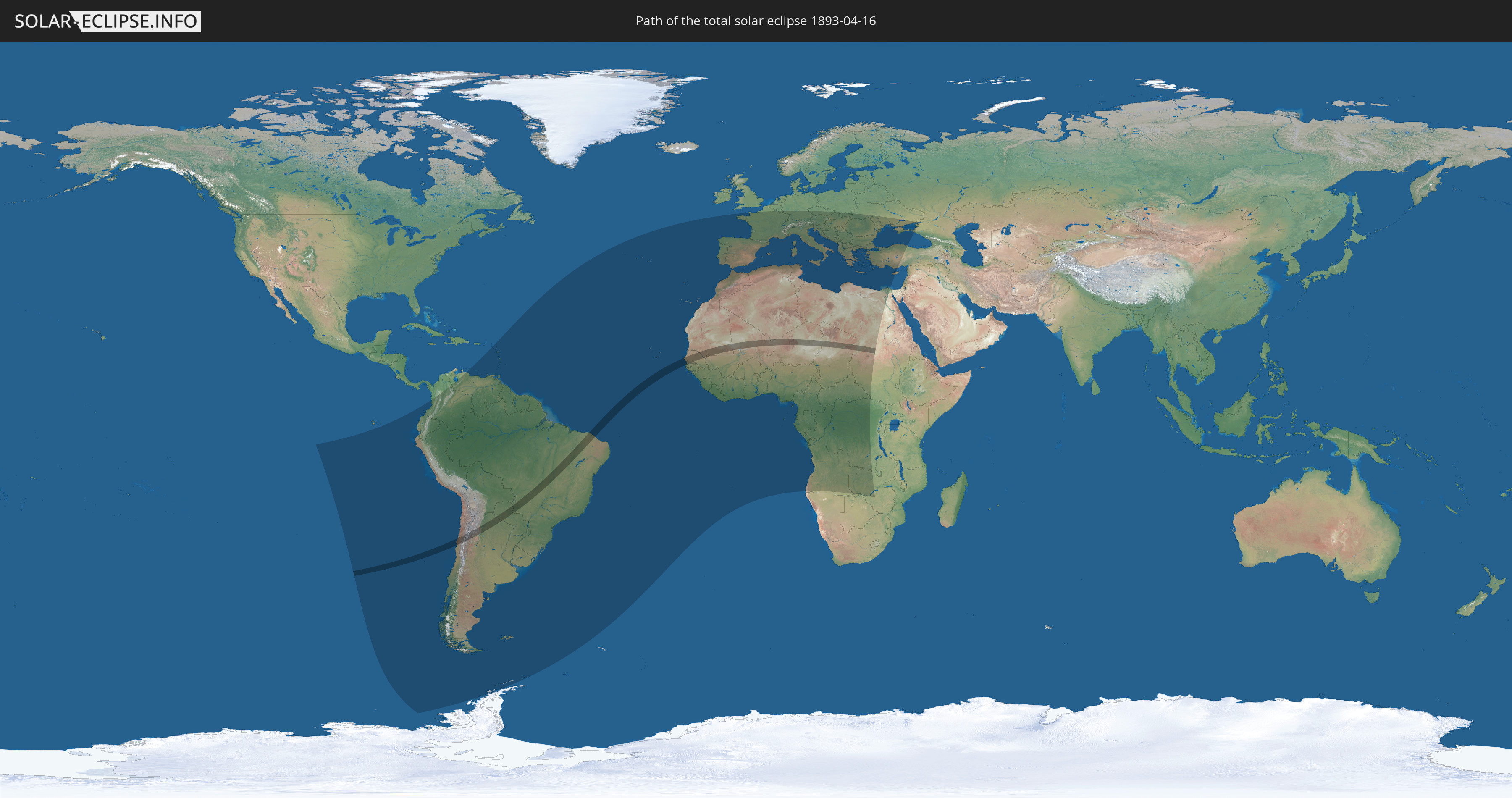
Totale Sonnenfinsternis vom 16.04.1893
| Wochentag: | Sonntag |
| Maximale Dauer der Verfinsterung: | 04m47s |
| Maximale Breite des Finsternispfades: | 186 km |
| Saroszyklus: | 127 |
| Bedeckungsgrad: | 100% |
| Magnitude: | 1.0556 |
| Gamma: | -0.1764 |
Wo kann man die Sonnenfinsternis vom 16.04.1893 sehen?
Die Sonnenfinsternis am 16.04.1893 kann man in 99 Ländern als partielle Sonnenfinsternis beobachten.
Der Finsternispfad verläuft durch 12 Länder. Nur in diesen Ländern ist sie als totale Sonnenfinsternis zu sehen.
In den folgenden Ländern ist die Sonnenfinsternis total zu sehen
 Chile
Chile
 Brasilien
 Argentinien
 Paraguay
 Senegal
 Mauretanien
 Gambia
 Mali
Mali
 Algerien
 Niger
Niger
 Tschad
 Sudan
Sudan
In den folgenden Ländern ist die Sonnenfinsternis partiell zu sehen
 Russland
 Antarktika
 Chile
Chile
 Ecuador
 Kolumbien
 Peru
Peru
 Brasilien
 Argentinien
 Venezuela
 Bolivien
 St. Kitts und Nevis
 Paraguay
 Antigua und Barbuda
 Montserrat
 Trinidad und Tobago
 Guadeloupe
 Grenada
 Dominica
 St. Vincent und die Grenadinen
 Falklandinseln
 Guyana
 Martinique
 St. Lucia
 Barbados
 Uruguay
 Suriname
 Französisch-Guayana
 Südgeorgien und die Südlichen Sandwichinseln
 Portugal
 Kap Verde
 Spanien
 Senegal
 Mauretanien
 Gambia
 Guinea-Bissau
 Guinea
 St. Helena
 Sierra Leone
 Marokko
 Mali
Mali
 Liberia
 Algerien
 Elfenbeinküste
 Burkina Faso
 Gibraltar
 Frankreich
 Ghana
Ghana
 Jersey
 Togo
Togo
 Niger
Niger
 Benin
Benin
 Andorra
 Belgien
 Nigeria
 Äquatorialguinea
 Luxemburg
 Deutschland
 Schweiz
 São Tomé und Príncipe
 Italien
 Monaco
 Tunesien
 Kamerun
 Gabun
Gabun
 Libyen
 Liechtenstein
 Österreich
 Republik Kongo
 Angola
 Namibia
 Tschechien
 Demokratische Republik Kongo
 San Marino
 Vatikanstadt
 Slowenien
 Tschad
 Kroatien
 Polen
Polen
 Malta
Malta
 Zentralafrikanische Republik
 Bosnien und Herzegowina
 Ungarn
 Slowakei
 Montenegro
 Serbien
 Albanien
 Griechenland
 Botswana
 Rumänien
 Mazedonien
 Sudan
Sudan
 Sambia
 Ukraine
 Bulgarien
 Ägypten
 Simbabwe
 Türkei
 Moldawien
 Republik Zypern
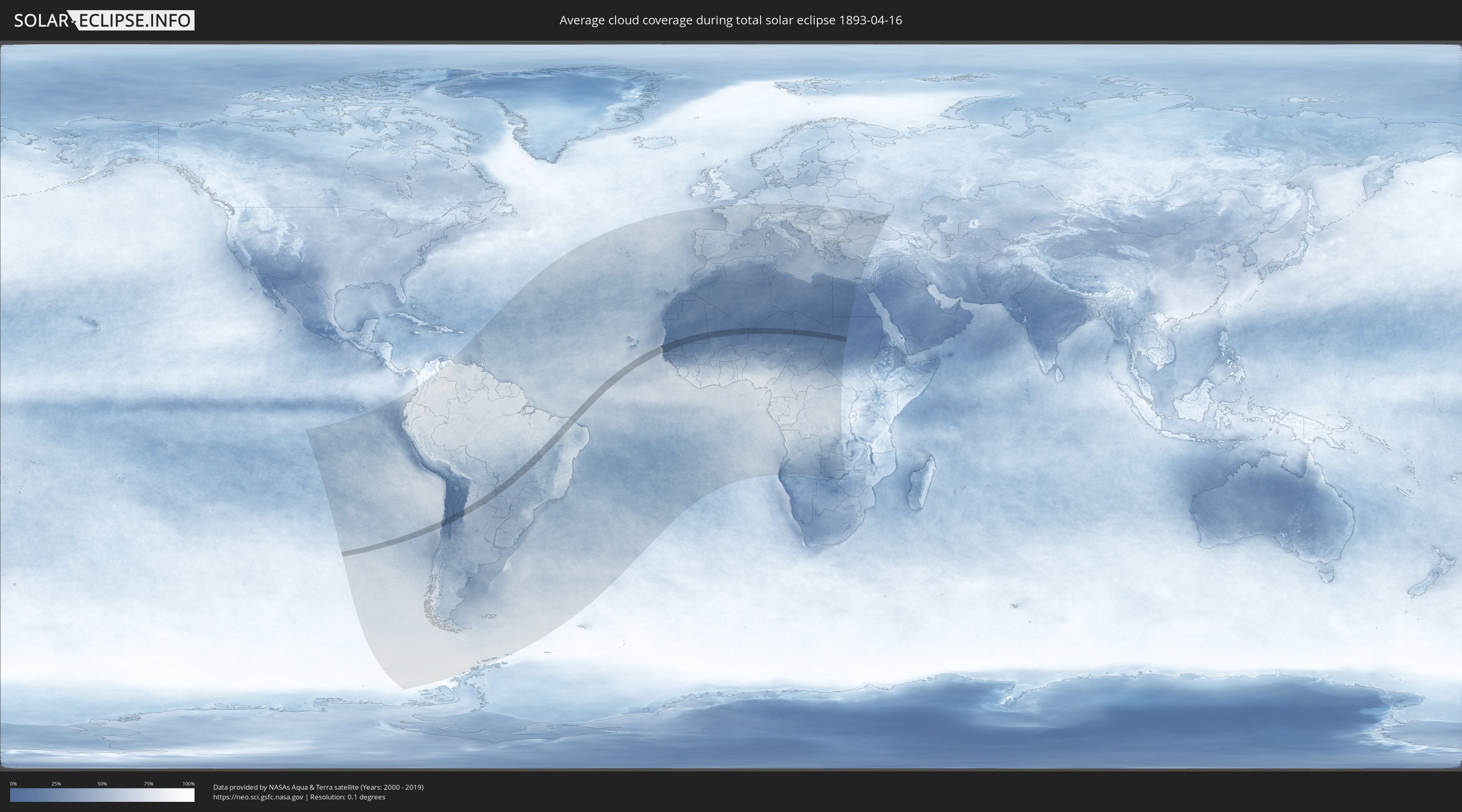
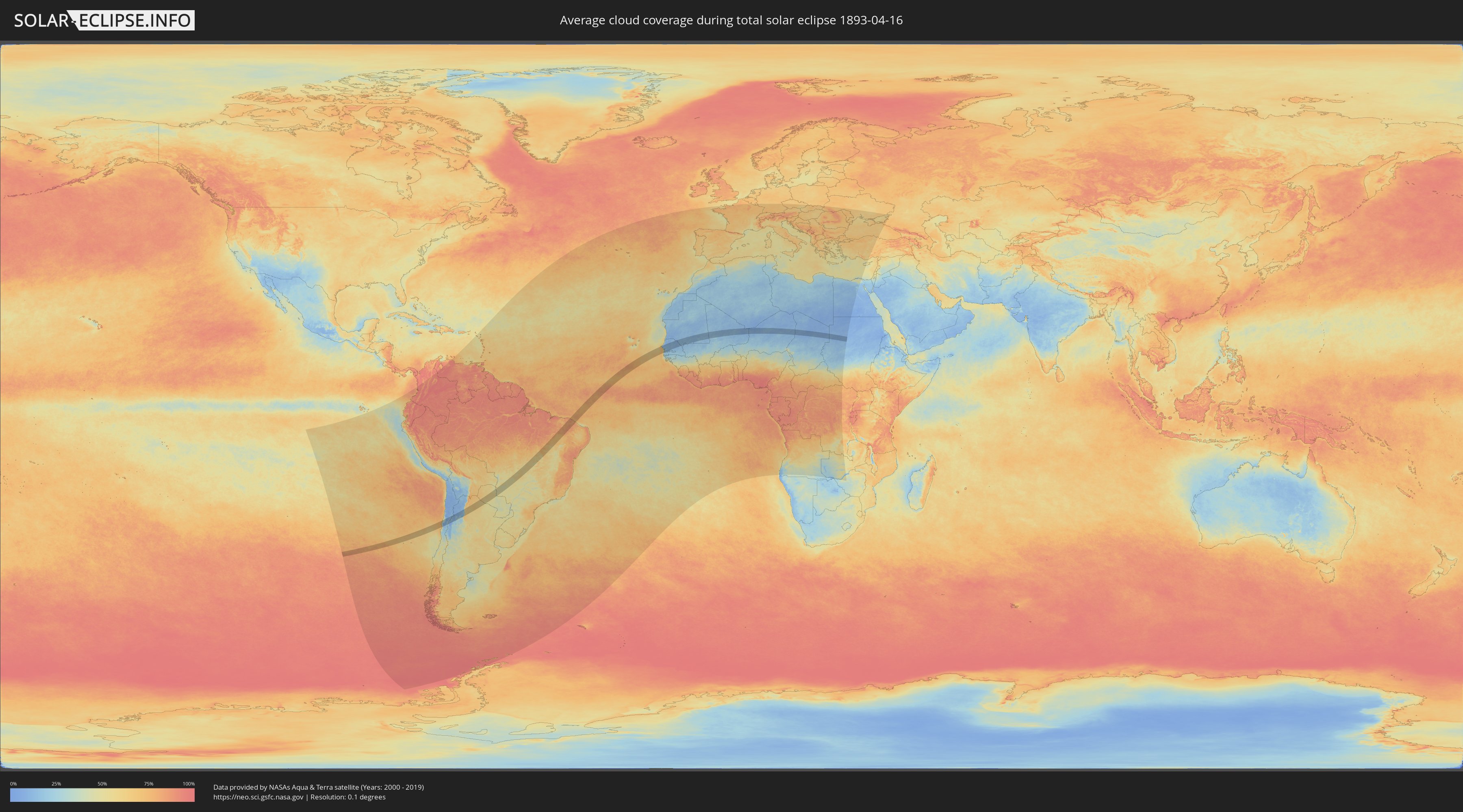
Wie wird das Wetter während der totalen Sonnenfinsternis am 16.04.1893?
Wo ist der beste Ort, um die totale Sonnenfinsternis vom 16.04.1893 zu beobachten?
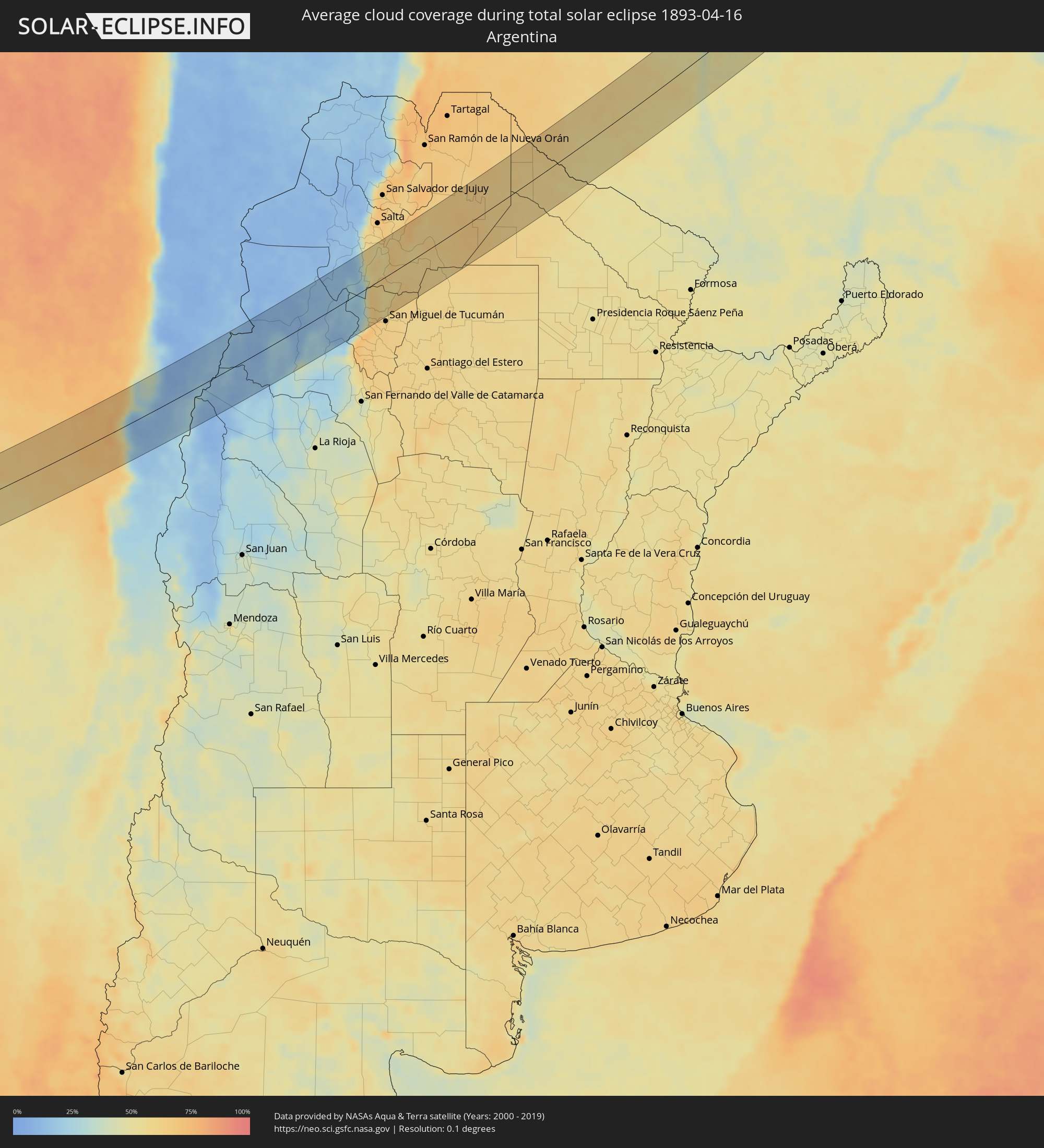
Die folgenden Karten zeigen die durchschnittliche Bewölkung für den Tag, an dem die totale Sonnenfinsternis
stattfindet. Mit Hilfe der Karten lässt sich der Ort entlang des Finsternispfades eingrenzen,
der die besten Aussichen auf einen klaren wolkenfreien Himmel bietet.
Trotzdem muss man immer lokale Gegenenheiten beachten und sollte sich genau über das Wetter an seinem
gewählten Beobachtungsort informieren.
Die Daten stammen von den beiden NASA-Satelliten
AQUA und TERRA
und wurden über einen Zeitraum von 19 Jahren (2000 - 2019) gemittelt.
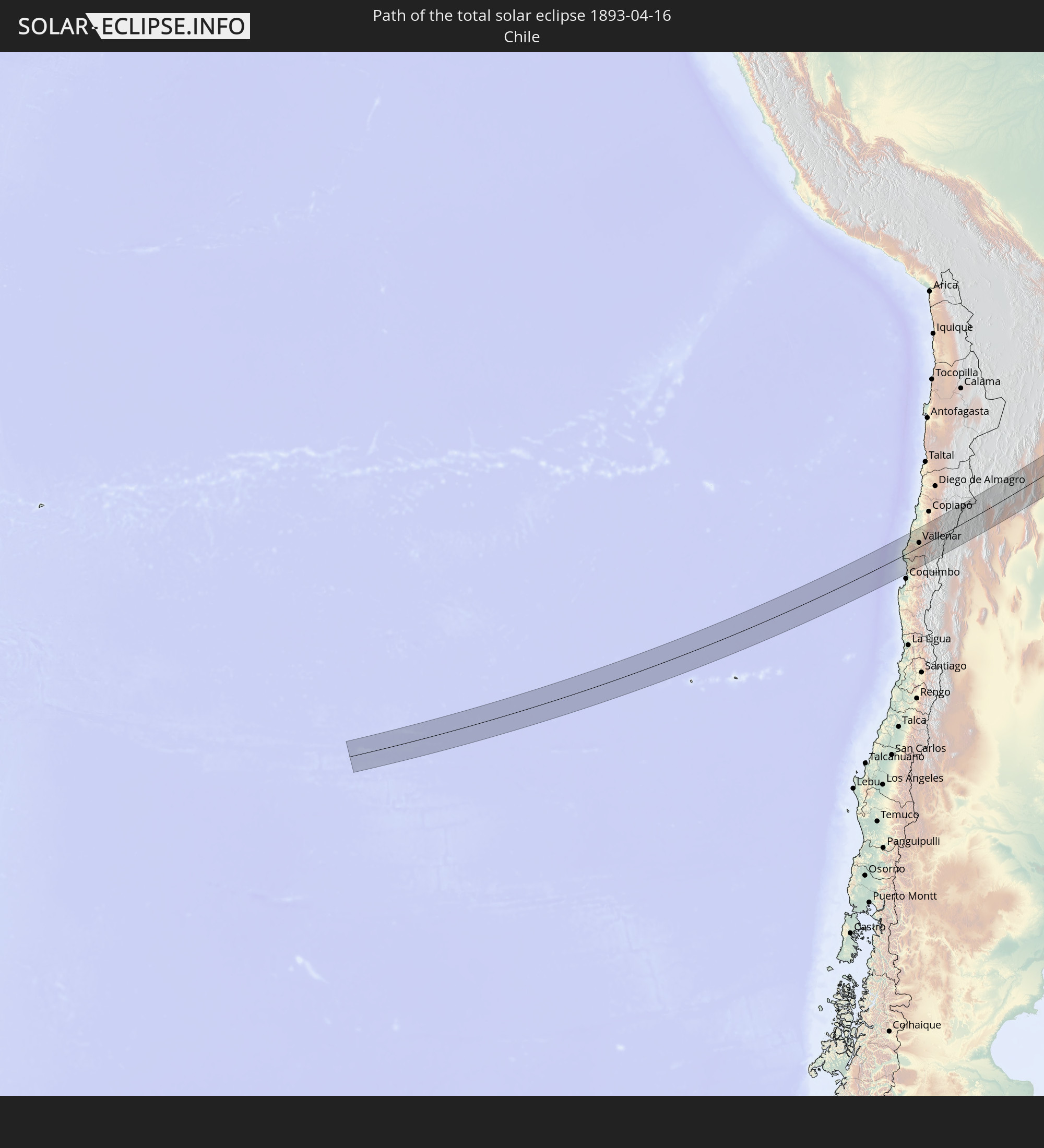
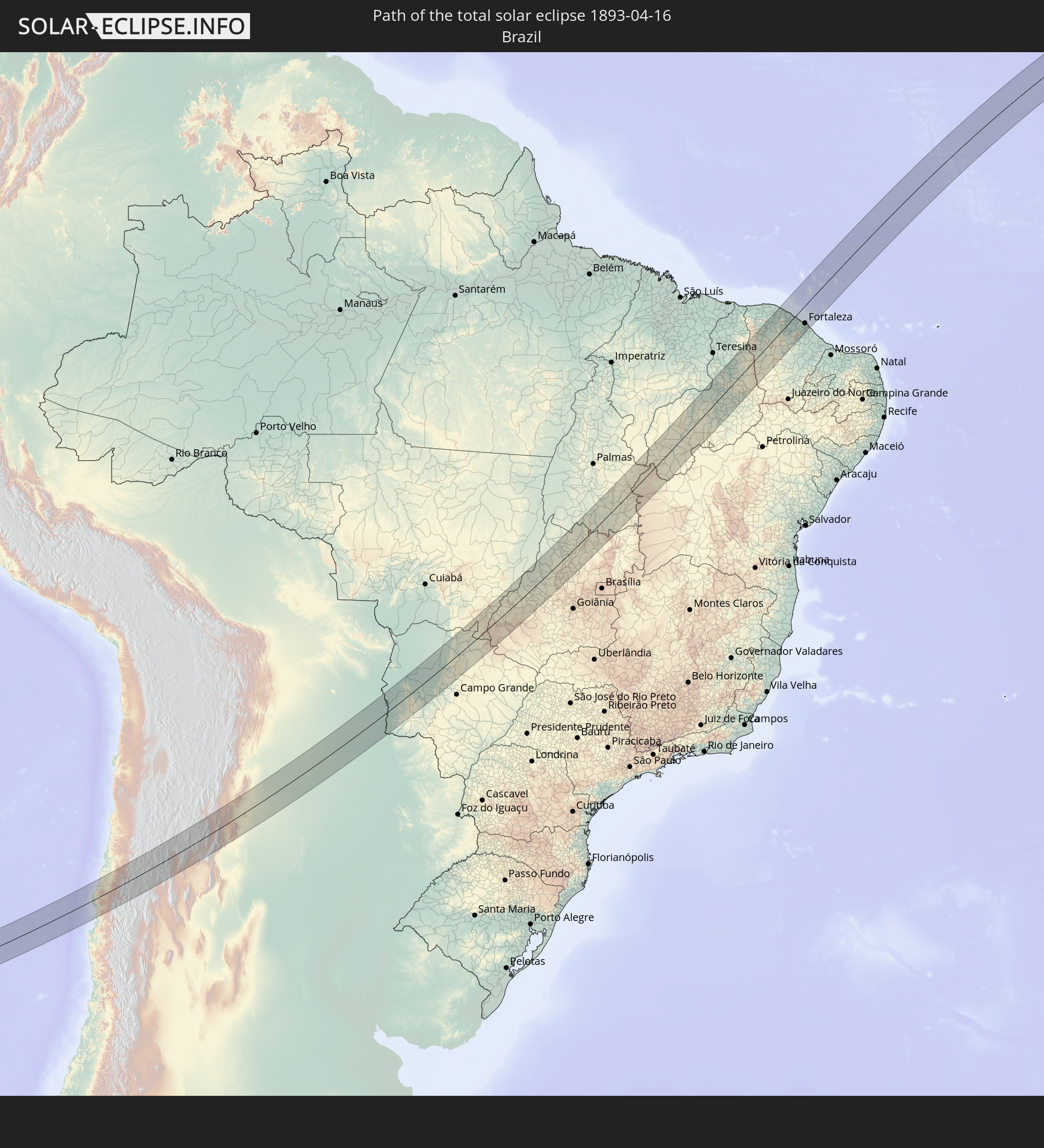
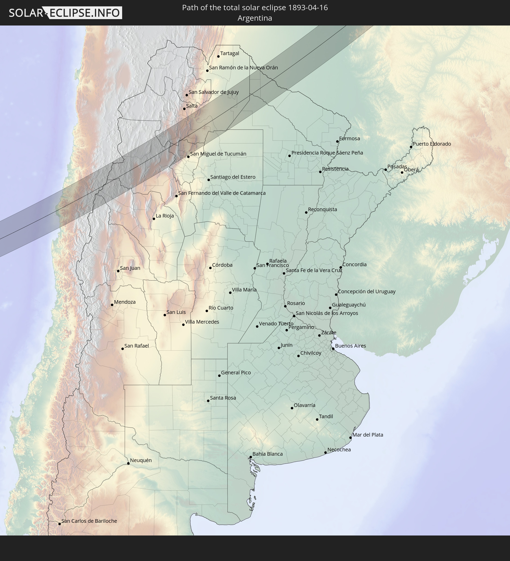
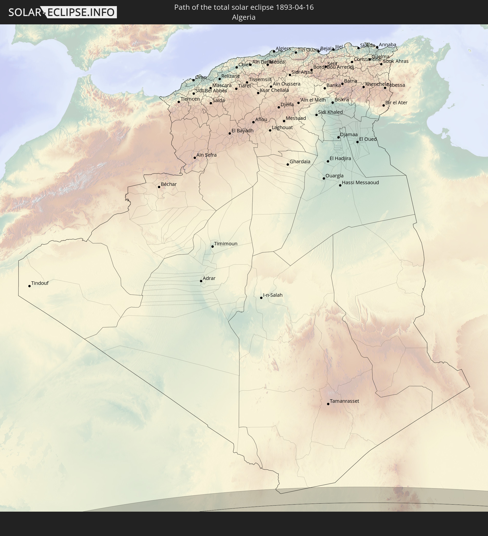
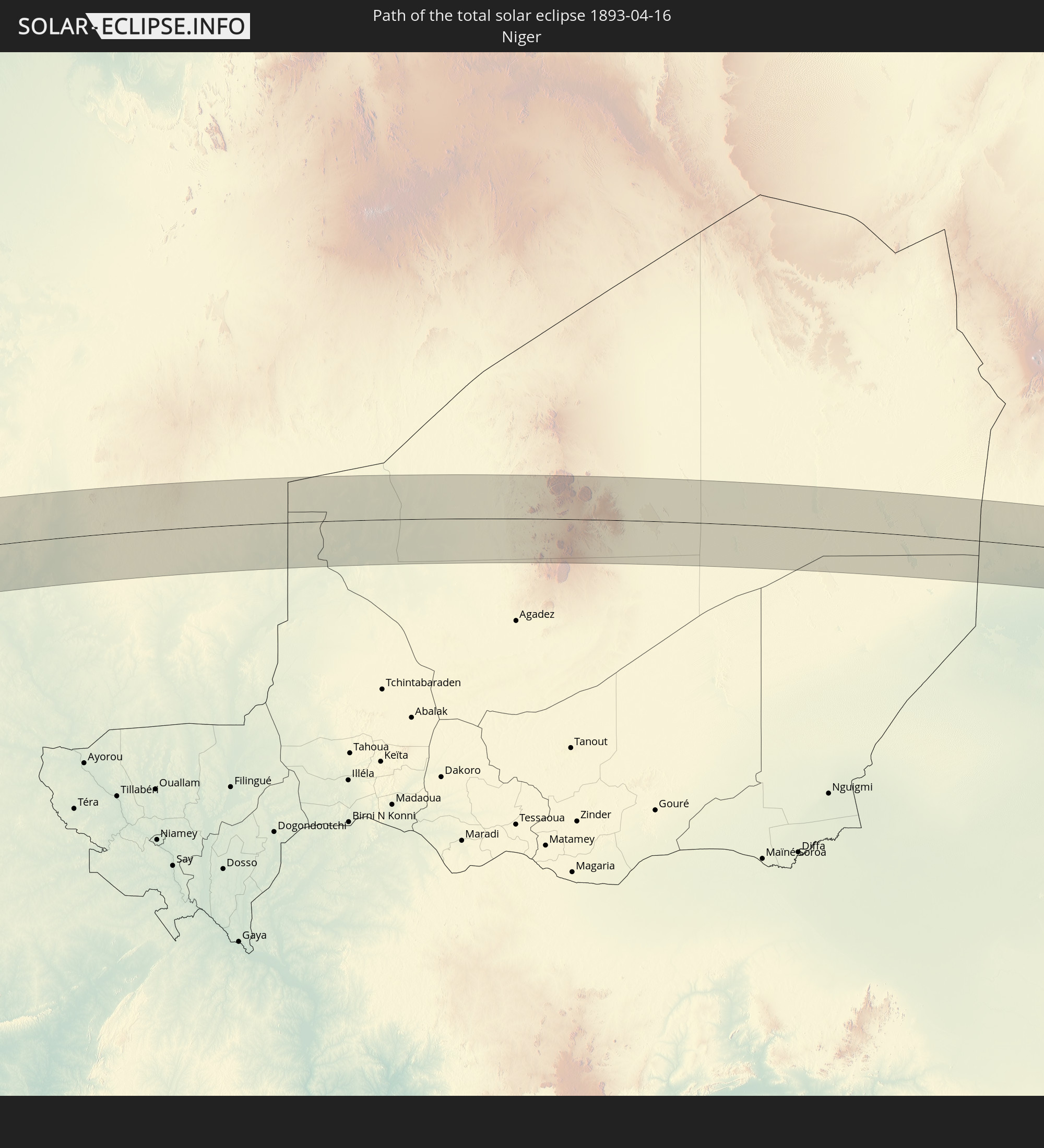
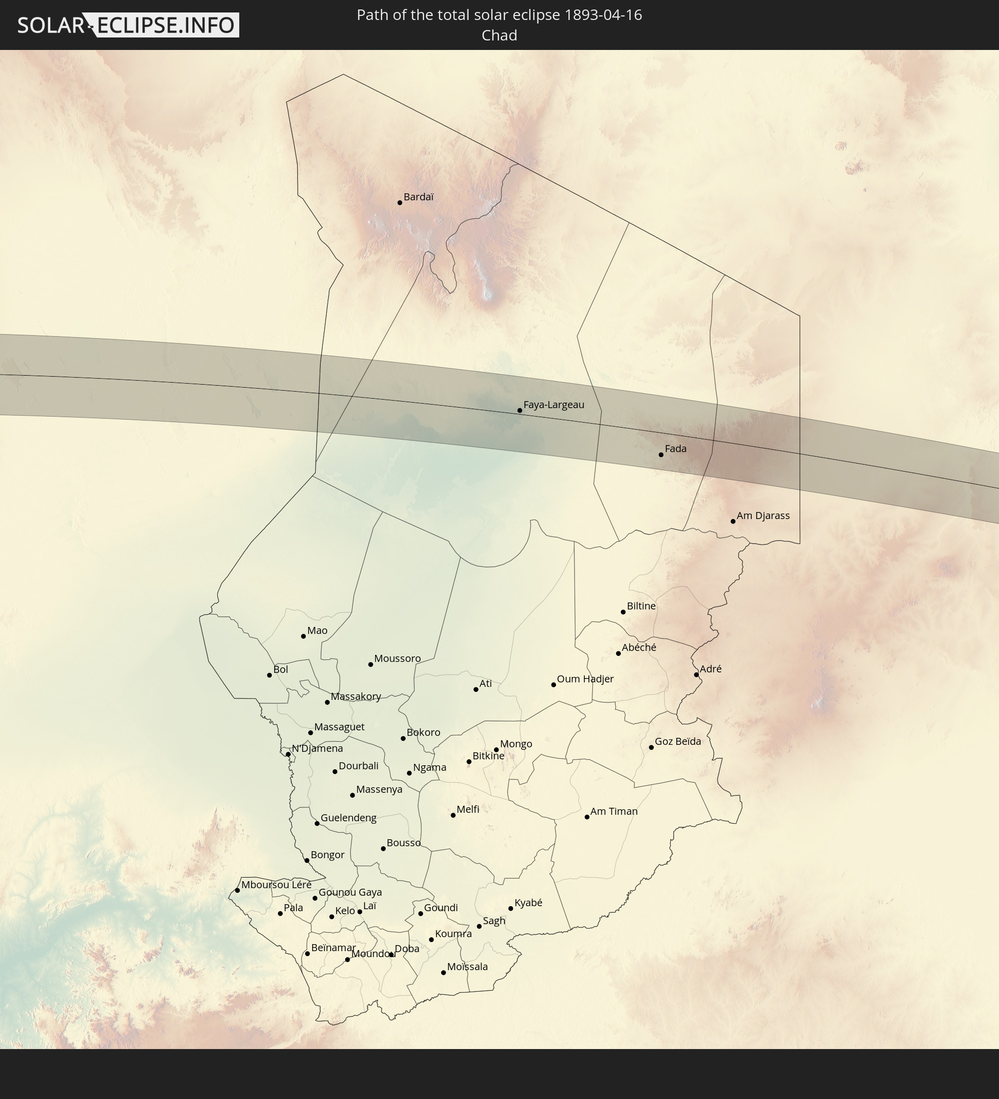
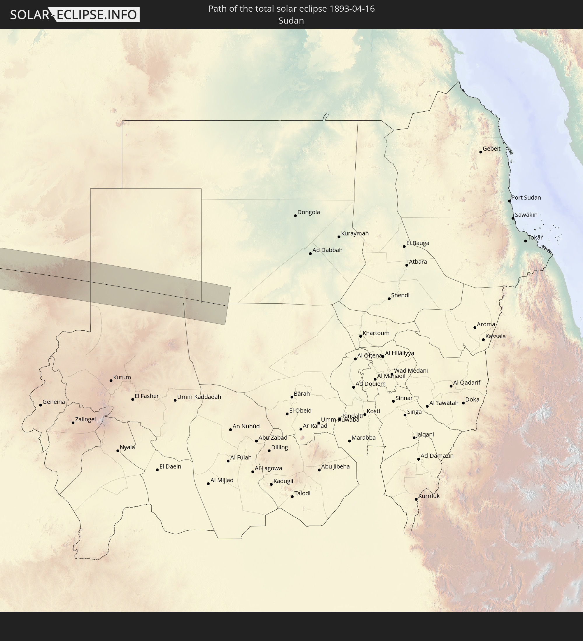
Detaillierte Länderkarten
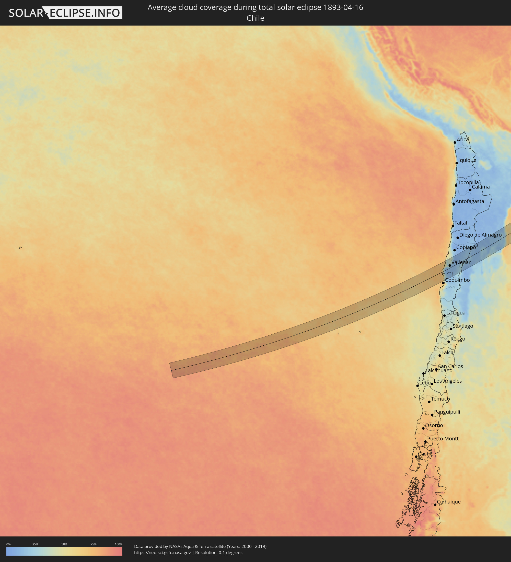 Chile
Chile
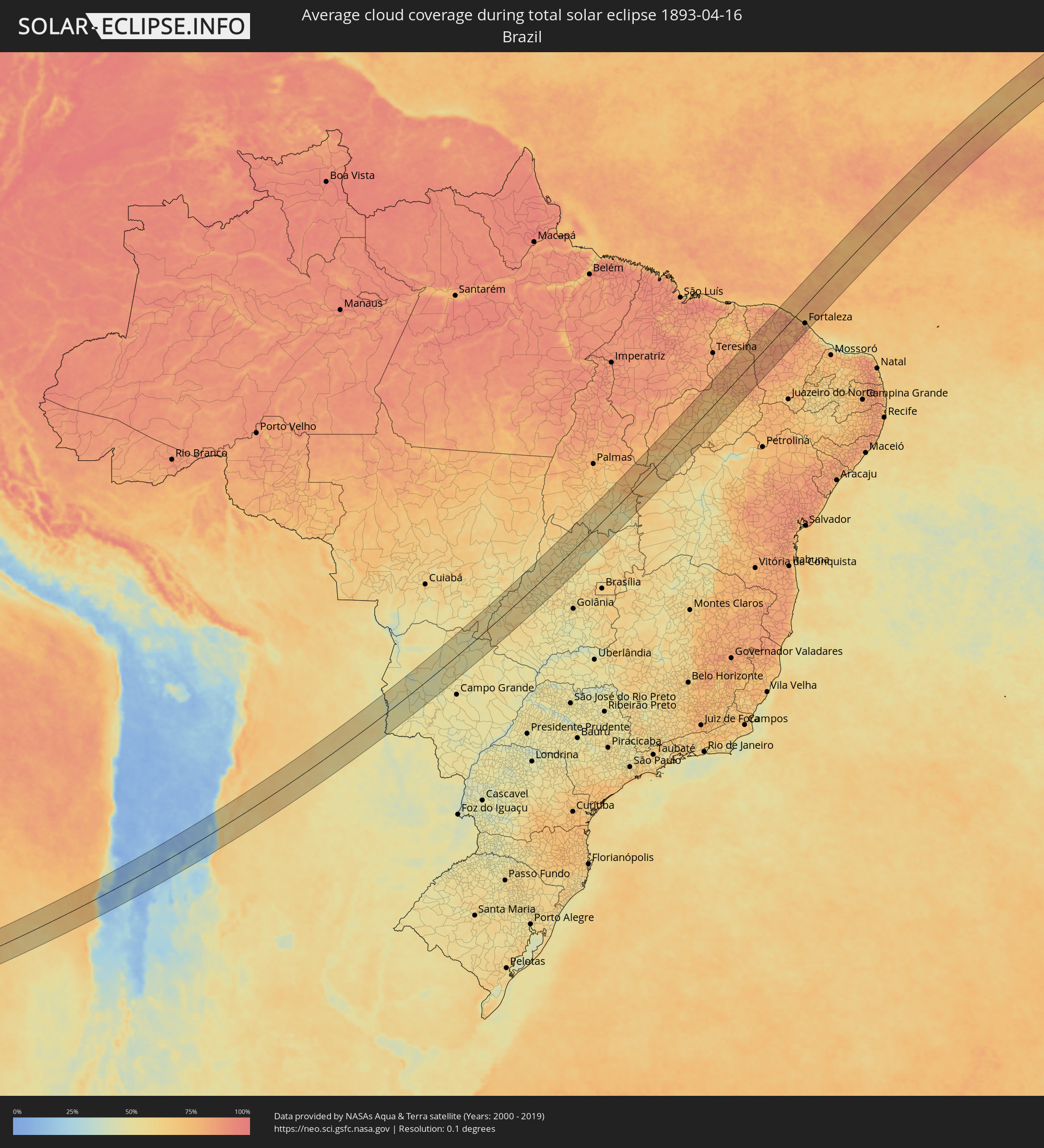 Brasilien
 Argentinien
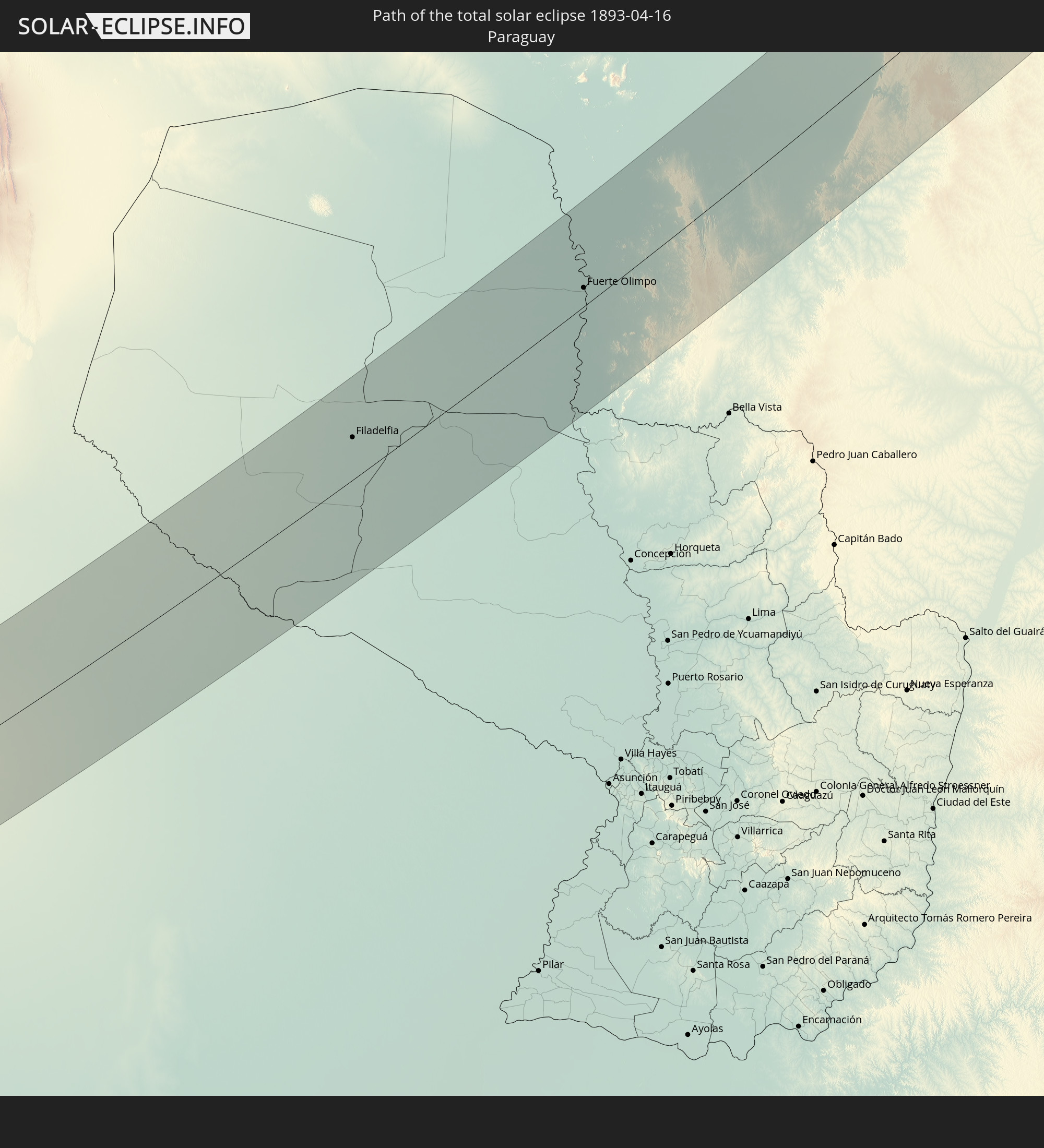
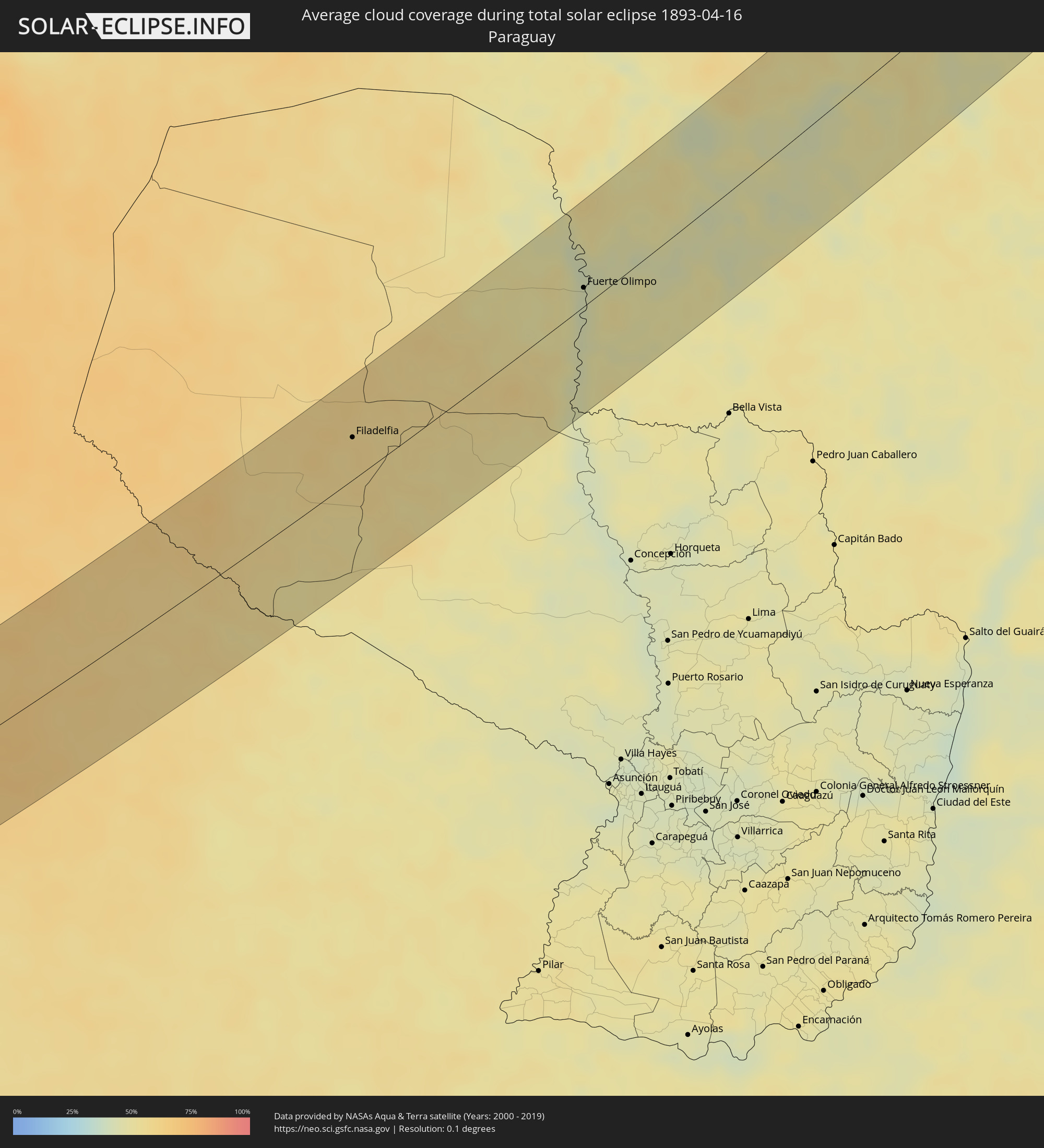 Paraguay
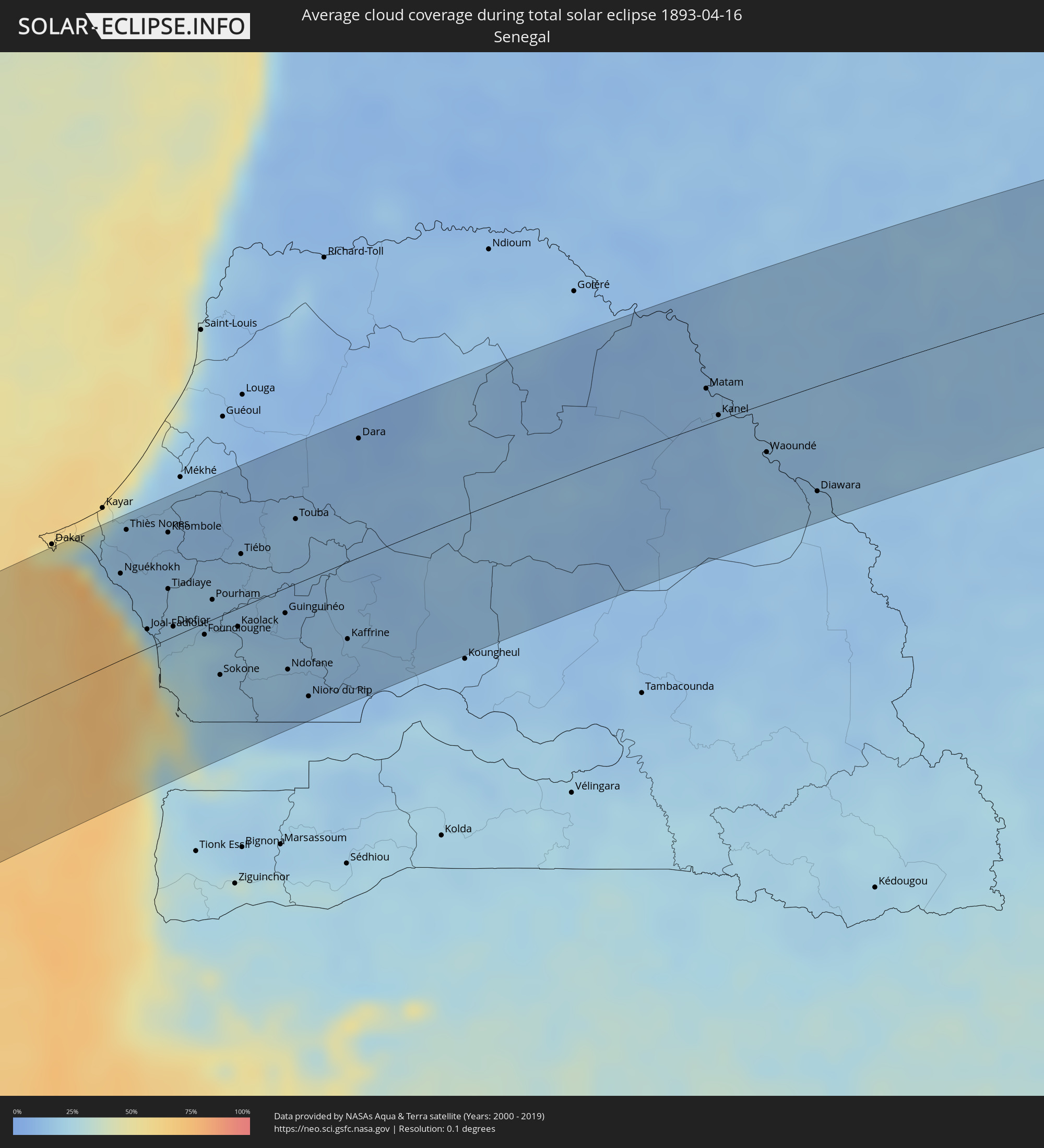 Senegal
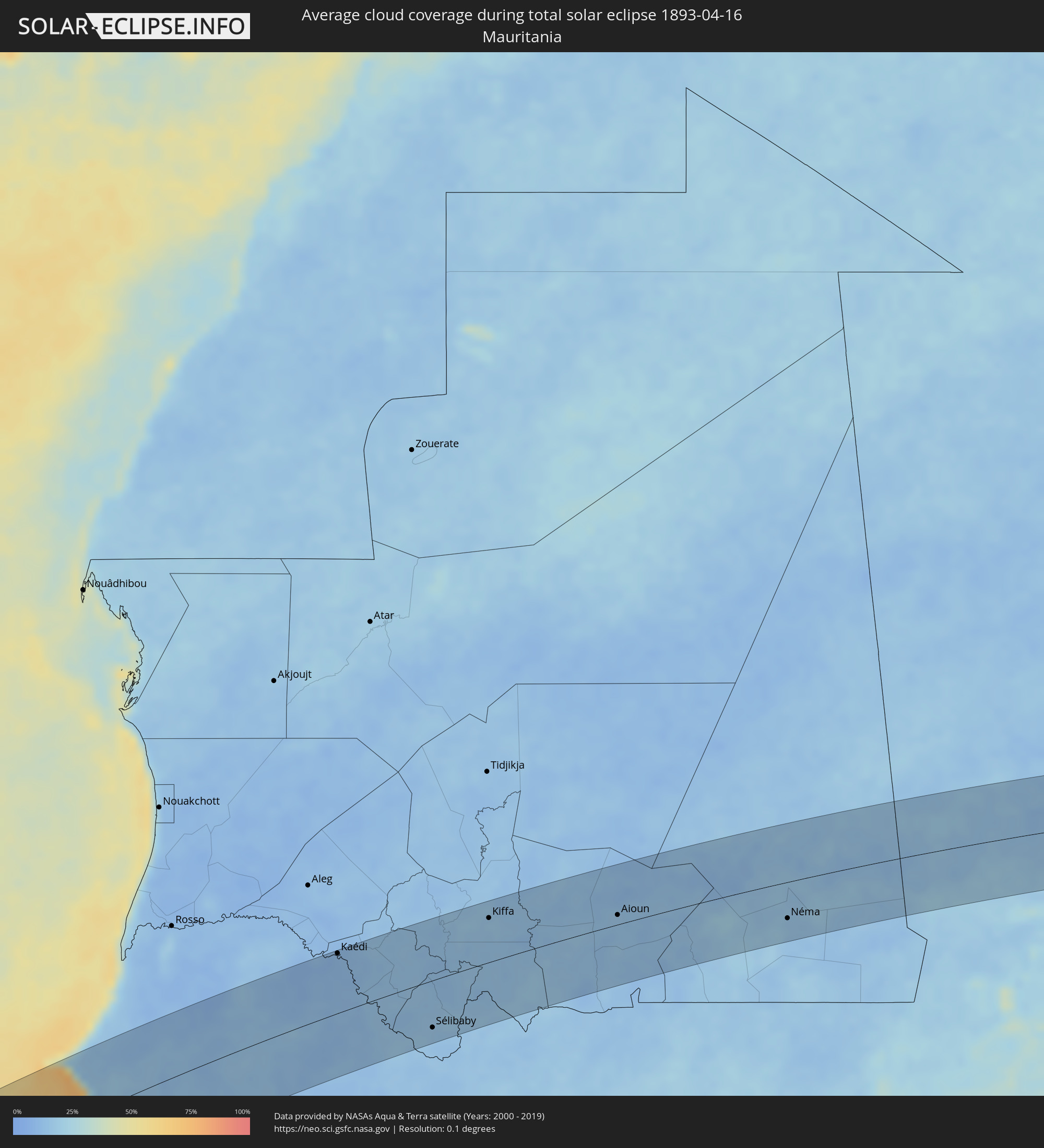 Mauretanien
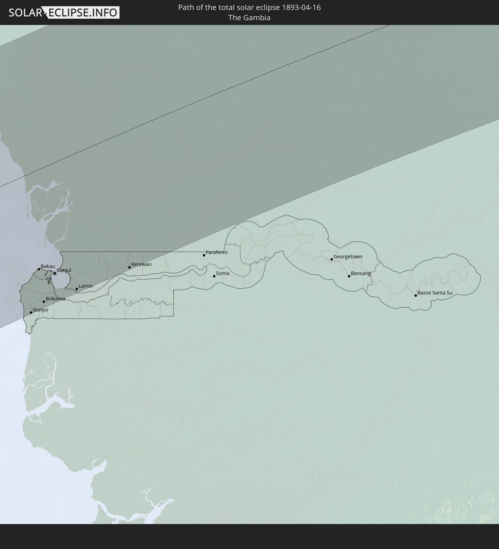
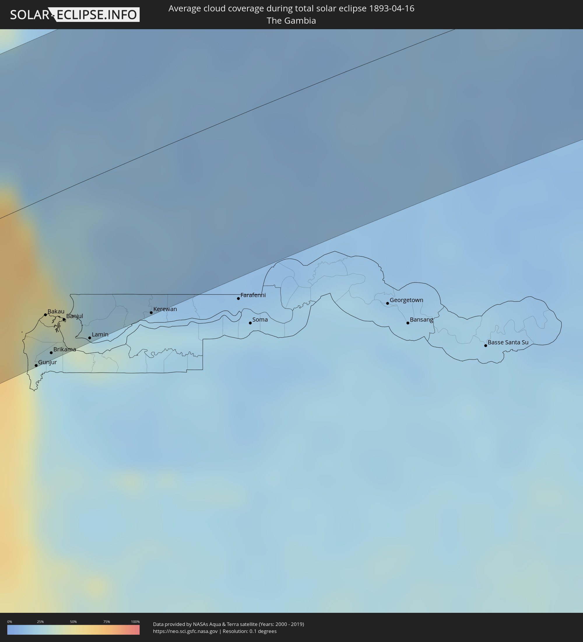 Gambia
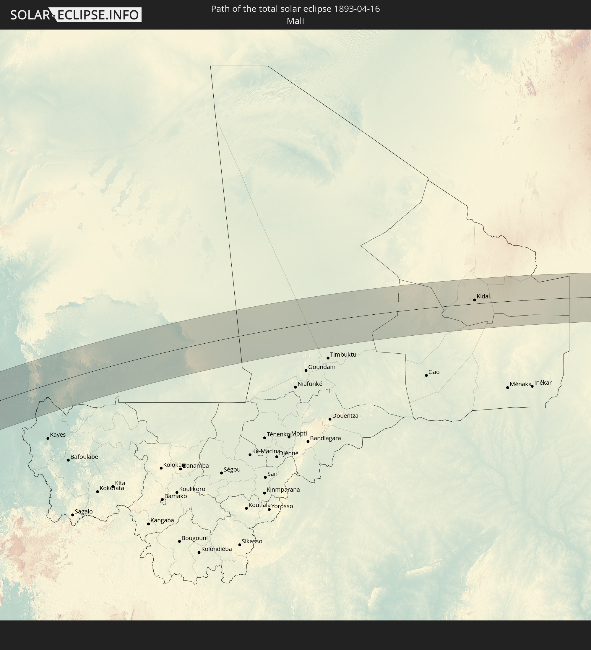
 Mali
Mali
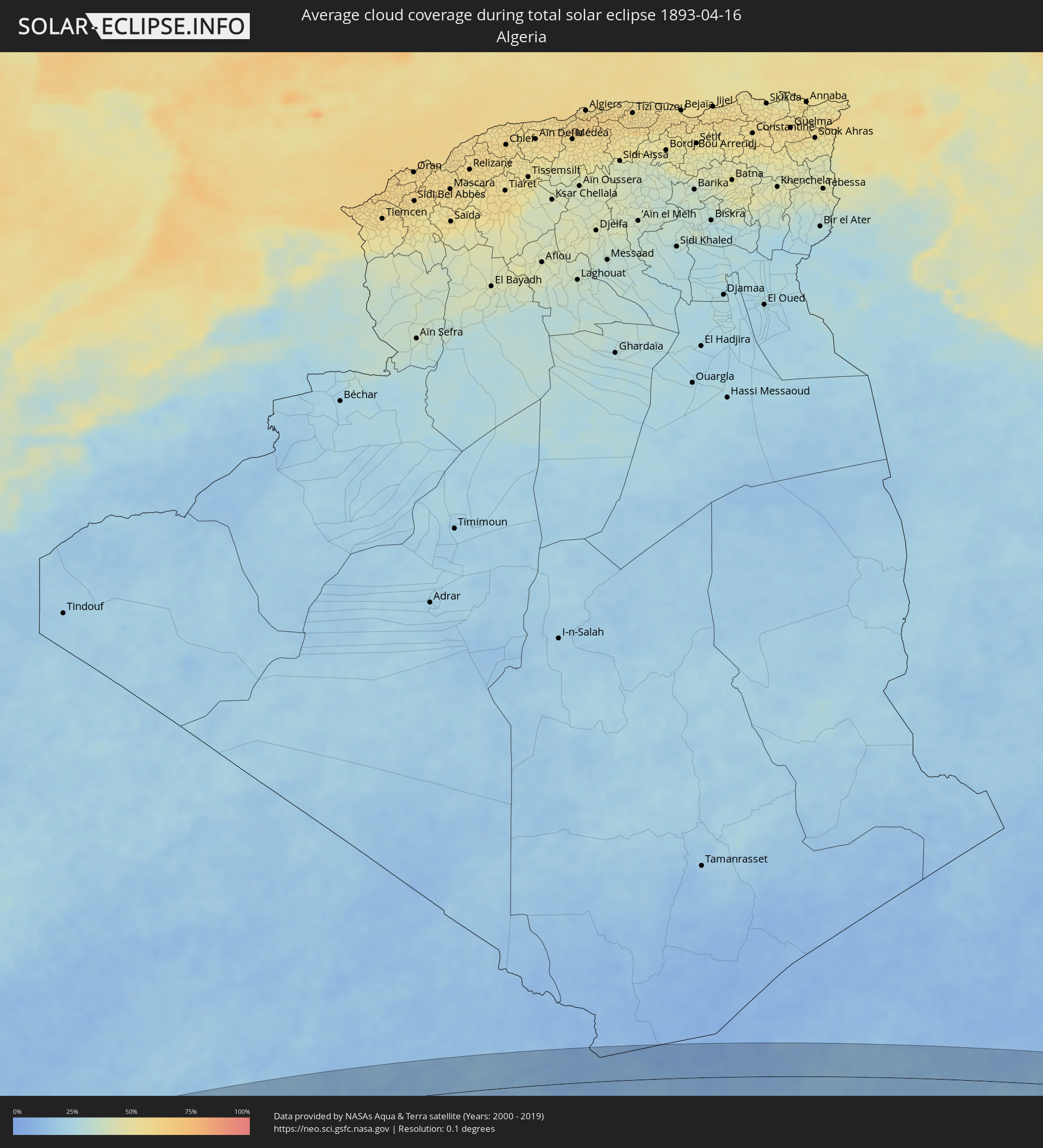 Algerien
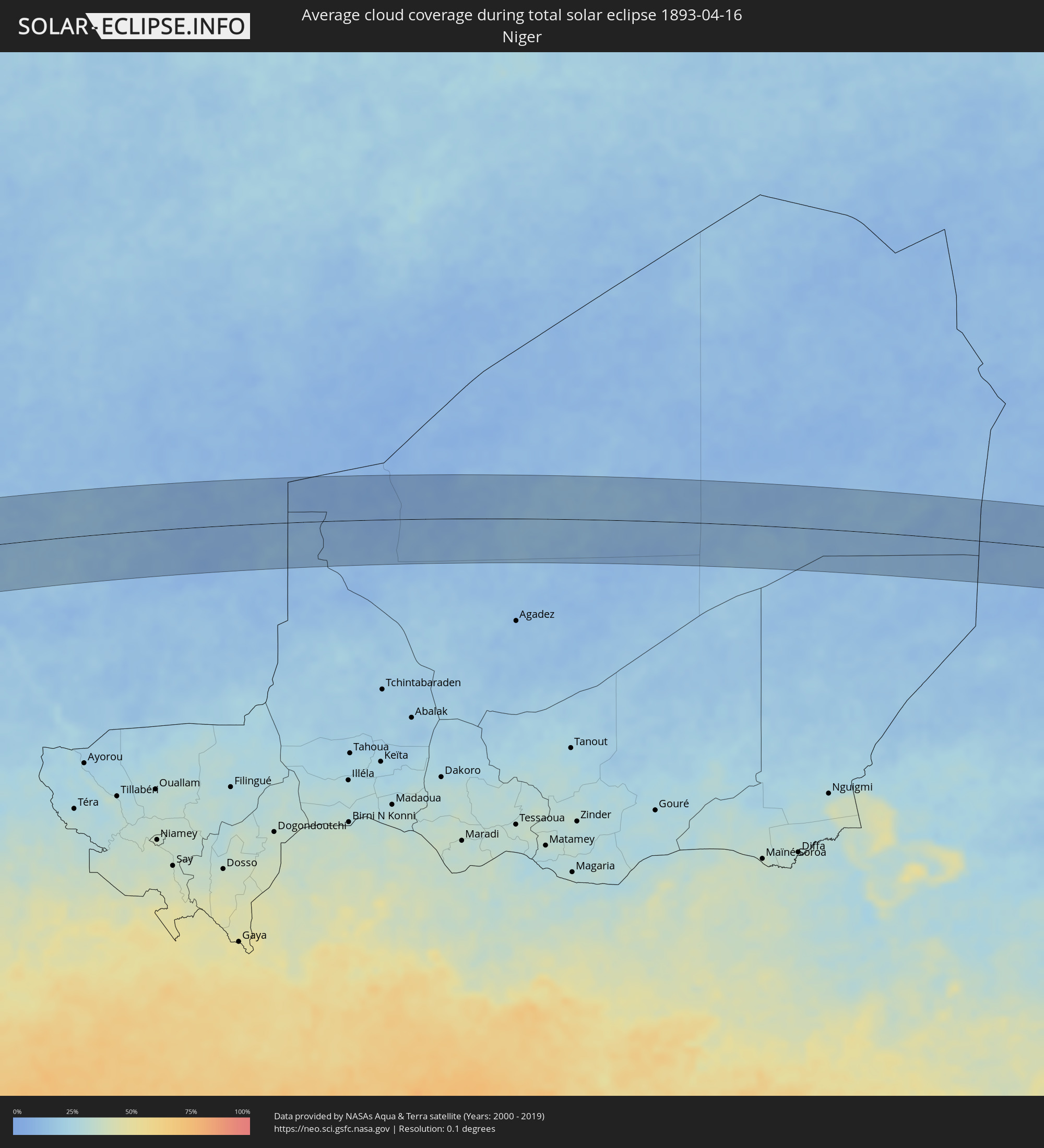 Niger
Niger
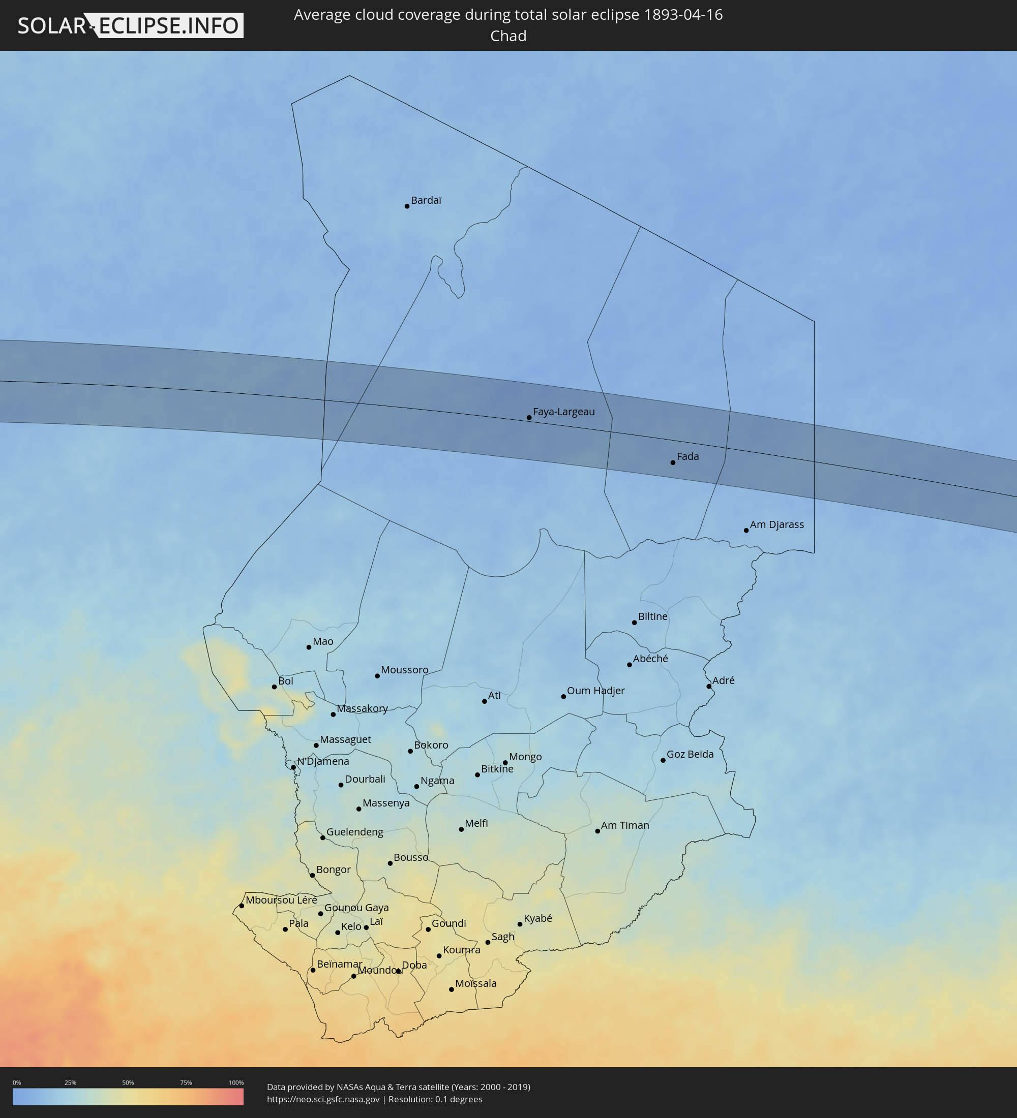 Tschad
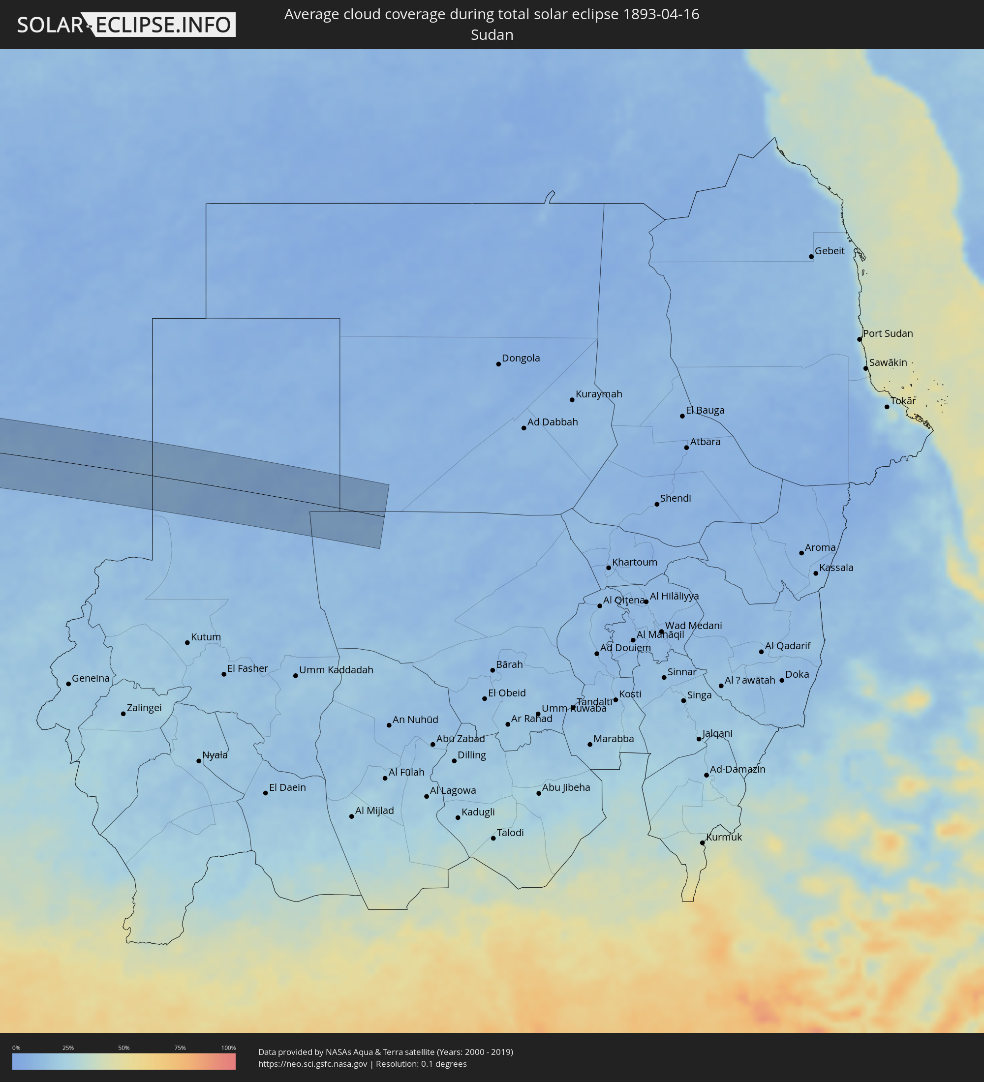 Sudan
Sudan
Orte im Finsternispfad
Die nachfolgene Tabelle zeigt Städte und Orte mit mehr als 5.000 Einwohnern, die sich im Finsternispfad befinden. Städte mit mehr als 100.000 Einwohnern sind dick gekennzeichnet. Mit einem Klick auf den Ort öffnet sich eine Detailkarte die die Lage des jeweiligen Ortes zusammen mit dem Verlauf der zentralen Finsternis präsentiert.
| Ort | Typ | Dauer der Verfinsterung | Ortszeit bei maximaler Verfinsterung | Entfernung zur Zentrallinie | Ø Bewölkung |
|
Vallenar, Atacama
|
total | - | 08:20:20 UTC-04:42 | 16 km | 24% |
|
Fiambalá, Catamarca Province
|
total | - | 08:49:03 UTC-04:16 | 48 km | 17% |
|
Cafayate, Salta Province
|
total | - | 08:51:18 UTC-04:16 | 23 km | 28% |
|
Trancas, Tucumán Province
|
total | - | 08:51:50 UTC-04:16 | 27 km | 54% |
|
Tafí Viejo, Tucumán Province
|
total | - | 08:51:32 UTC-04:16 | 77 km | 63% |
|
El Galpón, Salta Province
|
total | - | 08:52:55 UTC-04:16 | 18 km | 57% |
|
Las Lajitas, Salta Province
|
total | - | 08:53:46 UTC-04:16 | 62 km | 60% |
|
Joaquín V. González, Salta Province
|
total | - | 08:53:33 UTC-04:16 | 21 km | 63% |
|
El Quebrachal, Salta Province
|
total | - | 08:53:32 UTC-04:16 | 4 km | 61% |
|
Apolinario Saravia, Salta Province
|
total | - | 08:54:11 UTC-04:16 | 71 km | 63% |
|
Taco Pozo, Chaco Province
|
total | - | 08:54:02 UTC-04:16 | 79 km | 62% |
|
Ingeniero Guillermo N. Juárez, Formosa Province
|
total | - | 08:56:42 UTC-04:16 | 1 km | 60% |
|
Filadelfia, Boquerón
|
total | - | 09:26:04 UTC-03:50 | 33 km | 59% |
|
Colonia Menno, Boquerón
|
total | - | 09:26:16 UTC-03:50 | 17 km | 57% |
|
Fuerte Olimpo, Alto Paraguay
|
total | - | 09:29:44 UTC-03:50 | 14 km | 43% |
|
Aquidauana, Mato Grosso do Sul
|
total | - | 09:45:03 UTC-03:38 | 71 km | 51% |
|
Coxim, Mato Grosso do Sul
|
total | - | 09:48:35 UTC-03:38 | 28 km | 50% |
|
Mineiros, Goiás
|
total | - | 10:24:43 UTC-03:06 | 46 km | 53% |
|
Barra do Garças, Mato Grosso
|
total | - | 09:55:21 UTC-03:38 | 72 km | 52% |
|
Iporá, Goiás
|
total | - | 10:28:13 UTC-03:06 | 56 km | 54% |
|
Porangatu, Goiás
|
total | - | 10:35:31 UTC-03:06 | 40 km | 59% |
|
Uruaçu, Goiás
|
total | - | 10:33:53 UTC-03:06 | 47 km | 51% |
|
Floriano, Piauí
|
total | - | 11:29:41 UTC-02:34 | 73 km | 75% |
|
Picos, Piauí
|
total | - | 11:31:57 UTC-02:34 | 77 km | 78% |
|
Ipu, Ceará
|
total | - | 11:38:38 UTC-02:34 | 69 km | 82% |
|
Crateús, Ceará
|
total | - | 11:37:02 UTC-02:34 | 2 km | 80% |
|
Sobral, Ceará
|
partiell | - | 11:40:34 UTC-02:34 | 88 km | 80% |
|
Santa Quitéria, Ceará
|
total | - | 11:39:40 UTC-02:34 | 23 km | 81% |
|
Boa Viagem, Ceará
|
total | - | 11:38:56 UTC-02:34 | 72 km | 84% |
|
Itapagé, Ceará
|
total | - | 11:42:02 UTC-02:34 | 25 km | 87% |
|
Itapipoca, Ceará
|
total | - | 11:42:26 UTC-02:34 | 39 km | 82% |
|
Canindé, Ceará
|
total | - | 11:41:14 UTC-02:34 | 48 km | 80% |
|
Trairi, Ceará
|
total | - | 11:43:27 UTC-02:34 | 30 km | 83% |
|
São Gonçalo do Amarante, Ceará
|
total | - | 11:43:23 UTC-02:34 | 19 km | 83% |
|
Baturité, Ceará
|
total | - | 11:42:07 UTC-02:34 | 81 km | 89% |
|
Maracanaú, Ceará
|
total | - | 11:43:31 UTC-02:34 | 68 km | 82% |
|
Fortaleza, Ceará
|
total | - | 11:44:00 UTC-02:34 | 62 km | 78% |
|
Aquiraz, Ceará
|
total | - | 11:43:56 UTC-02:34 | 89 km | 78% |
|
Pout, Thiès
|
total | - | 15:19:15 UTC-00:16 | 83 km | 18% |
|
Nguékhokh, Thiès
|
total | - | 15:19:02 UTC-00:16 | 55 km | 34% |
|
Thiès Nones, Thiès
|
total | - | 15:19:26 UTC-00:16 | 80 km | 15% |
|
Joal-Fadiout, Thiès
|
total | - | 15:18:54 UTC-00:16 | 12 km | 35% |
|
Gunjur, Western
|
total | - | 15:17:51 UTC-00:16 | 91 km | 28% |
|
Sukuta, Western
|
total | - | 15:18:10 UTC-00:16 | 71 km | 27% |
|
Khombole, Thiès
|
total | - | 15:19:54 UTC-00:16 | 67 km | 13% |
|
Tiadiaye, Thiès
|
total | - | 15:19:28 UTC-00:16 | 31 km | 16% |
|
Bakau, Banjul
|
total | - | 15:18:18 UTC-00:16 | 65 km | 35% |
|
Diofior, Fatick
|
total | - | 15:19:14 UTC-00:16 | 6 km | 21% |
|
Abuko, Western
|
total | - | 15:18:15 UTC-00:16 | 73 km | 27% |
|
Brikama, Western
|
total | - | 15:18:06 UTC-00:16 | 87 km | 26% |
|
Banjul, Banjul
|
total | - | 15:18:28 UTC-00:16 | 72 km | 39% |
|
Barra, North Bank
|
total | - | 15:18:34 UTC-00:16 | 70 km | 32% |
|
Essau, North Bank
|
total | - | 15:18:35 UTC-00:16 | 71 km | 32% |
|
Lamin, North Bank
|
total | - | 15:18:36 UTC-00:16 | 89 km | 31% |
|
Pourham, Fatick
|
total | - | 15:19:54 UTC-00:16 | 12 km | 15% |
|
Sokone, Fatick
|
total | - | 15:19:24 UTC-00:16 | 37 km | 22% |
|
Gandiaye, Kaolack
|
total | - | 15:20:02 UTC-00:16 | 6 km | 20% |
|
Kaolack, Kaolack
|
total | - | 15:19:59 UTC-00:16 | 12 km | 20% |
|
Tiébo, Diourbel
|
total | - | 15:20:35 UTC-00:16 | 34 km | 14% |
|
Kerewan, North Bank
|
total | - | 15:19:25 UTC-00:16 | 90 km | 27% |
|
Guinguinéo, Fatick
|
total | - | 15:20:39 UTC-00:16 | 16 km | 14% |
|
Ndofane, Kaolack
|
total | - | 15:20:14 UTC-00:16 | 53 km | 16% |
|
Touba, Diourbel
|
total | - | 15:21:28 UTC-00:16 | 41 km | 14% |
|
Nioro du Rip, Kaolack
|
total | - | 15:20:17 UTC-00:16 | 75 km | 12% |
|
Kaffrine, Kaffrine
|
total | - | 15:21:10 UTC-00:16 | 49 km | 14% |
|
Dara, Louga
|
total | - | 15:22:47 UTC-00:16 | 76 km | 10% |
|
Ndibène Dahra, Louga
|
total | - | 15:22:46 UTC-00:16 | 74 km | 10% |
|
Kaédi, Gorgol
|
total | - | 15:27:04 UTC-00:16 | 84 km | 11% |
|
Ouro Sogui, Matam
|
total | - | 15:26:48 UTC-00:16 | 20 km | 12% |
|
Matam, Matam
|
total | - | 15:26:58 UTC-00:16 | 23 km | 12% |
|
Kanel, Matam
|
total | - | 15:26:55 UTC-00:16 | 3 km | 12% |
|
Waoundé, Matam
|
total | - | 15:27:12 UTC-00:16 | 32 km | 15% |
|
Sélibaby, Guidimaka
|
total | - | 15:28:14 UTC-00:16 | 67 km | 15% |
|
Kiffa, Assaba
|
total | - | 15:30:59 UTC-00:16 | 63 km | 17% |
|
Aioun, Hodh El Gharbi
|
total | - | 15:33:49 UTC-00:16 | 14 km | 16% |
|
Néma, Hodh ech Chargui
|
total | - | 15:37:18 UTC-00:16 | 52 km | 16% |
|
Kidal, Kidal
|
total | - | 15:49:14 UTC-00:16 | 11 km | 14% |
|
Faya-Largeau, Borkou
|
total | - | 17:17:19 UTC+01:00 | 6 km | 8% |
|
Fada, Ennedi-Ouest
|
total | - | 17:17:53 UTC+01:00 | 42 km | 10% |