Totale Sonnenfinsternis vom 25.05.2142
| Wochentag: | Freitag |
| Maximale Dauer der Verfinsterung: | 03m17s |
| Maximale Breite des Finsternispfades: | 187 km |
| Saroszyklus: | 130 |
| Bedeckungsgrad: | 100% |
| Magnitude: | 1.0449 |
| Gamma: | 0.5937 |
Wo kann man die Sonnenfinsternis vom 25.05.2142 sehen?
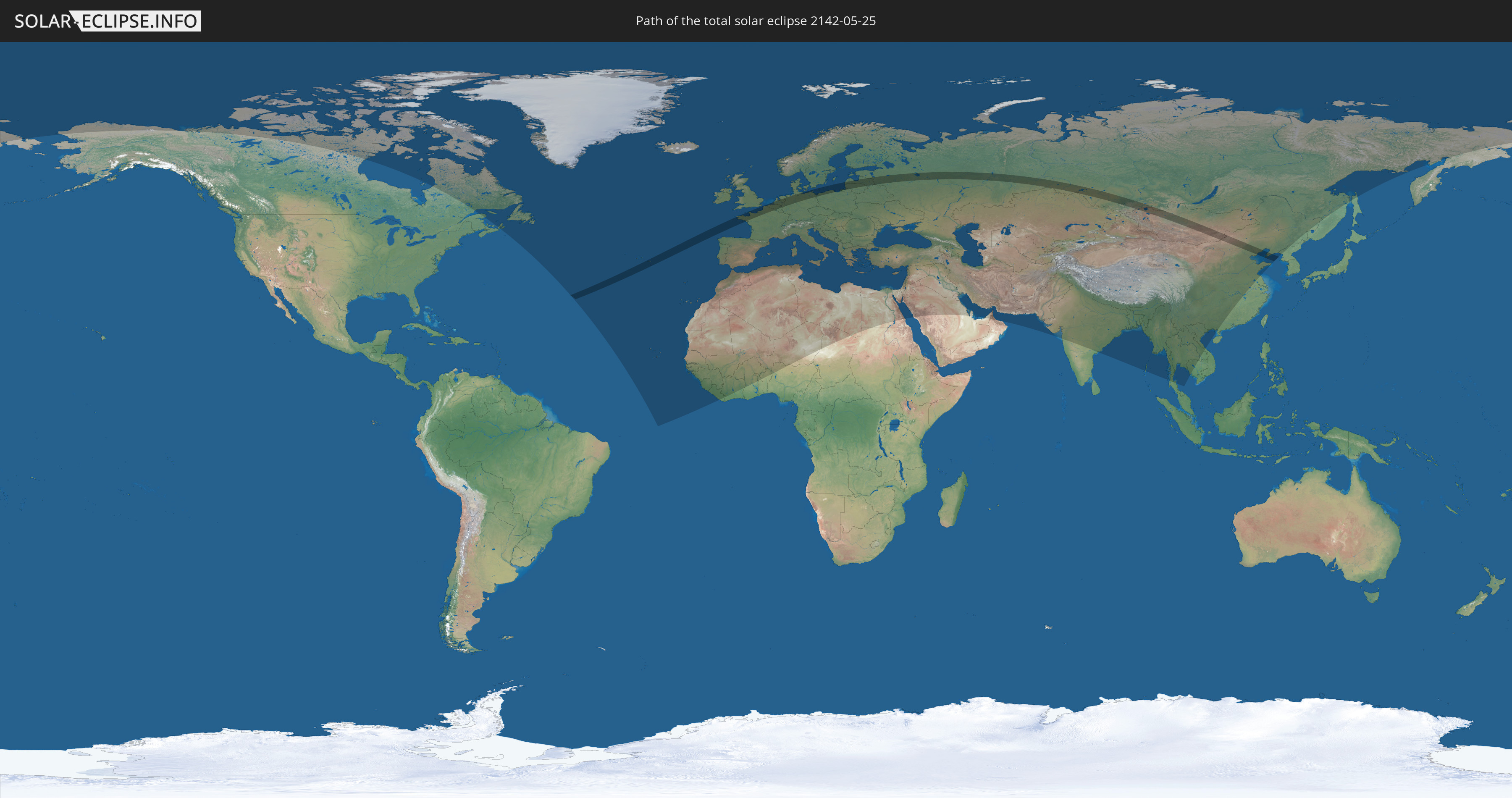
Die Sonnenfinsternis am 25.05.2142 kann man in 115 Ländern als partielle Sonnenfinsternis beobachten.
Der Finsternispfad verläuft durch 16 Länder. Nur in diesen Ländern ist sie als totale Sonnenfinsternis zu sehen.
In den folgenden Ländern ist die Sonnenfinsternis total zu sehen
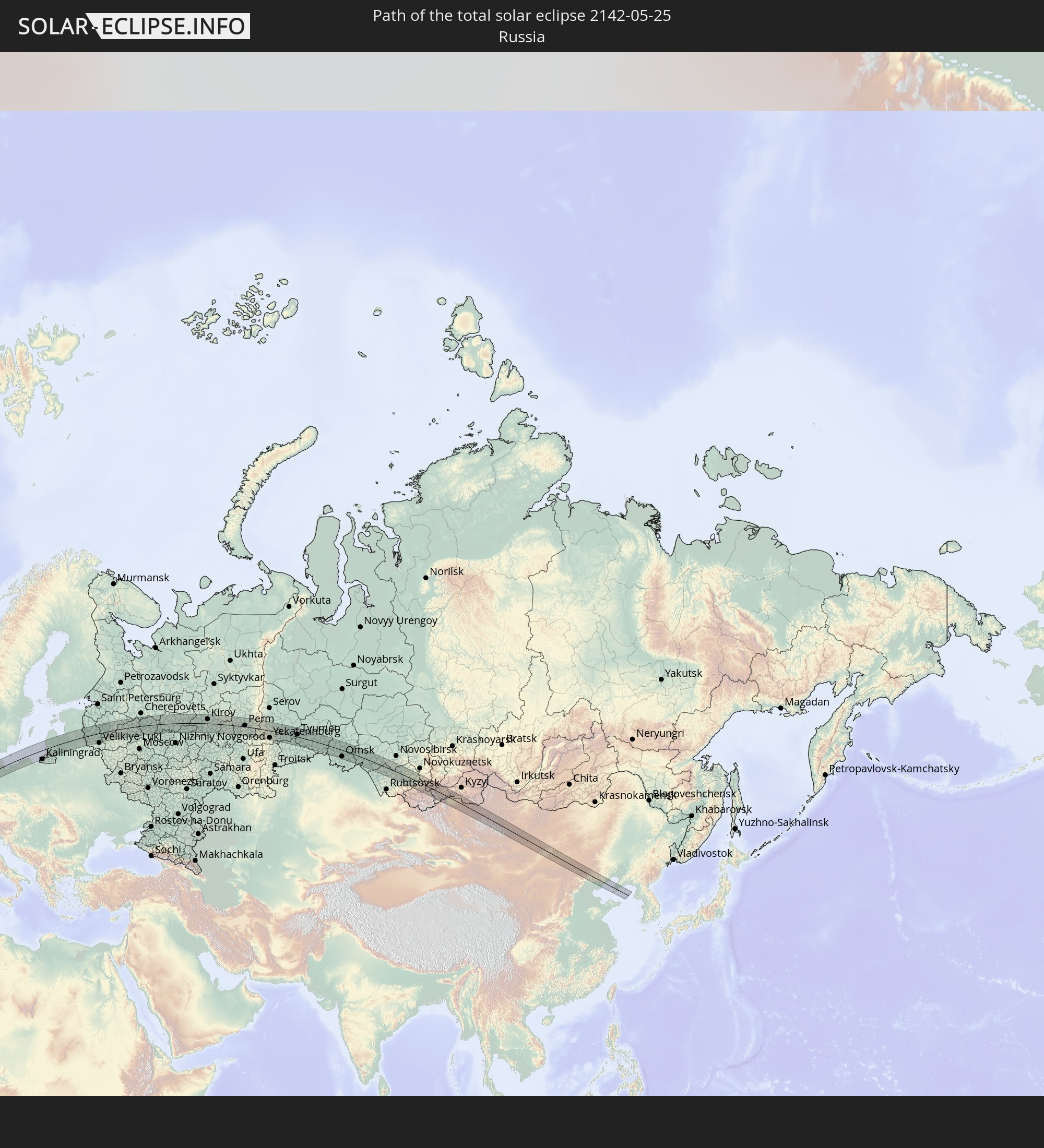 Russland
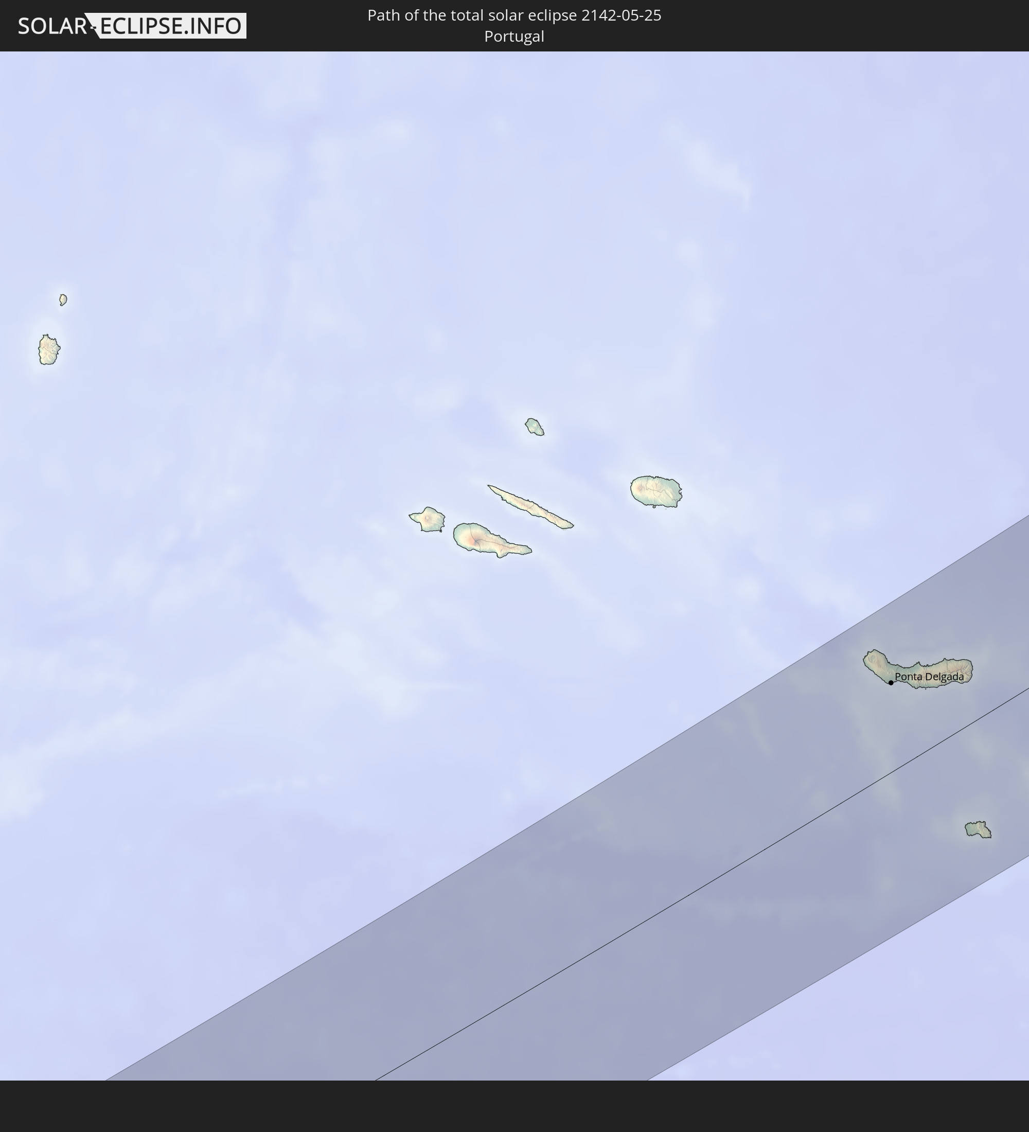 Portugal
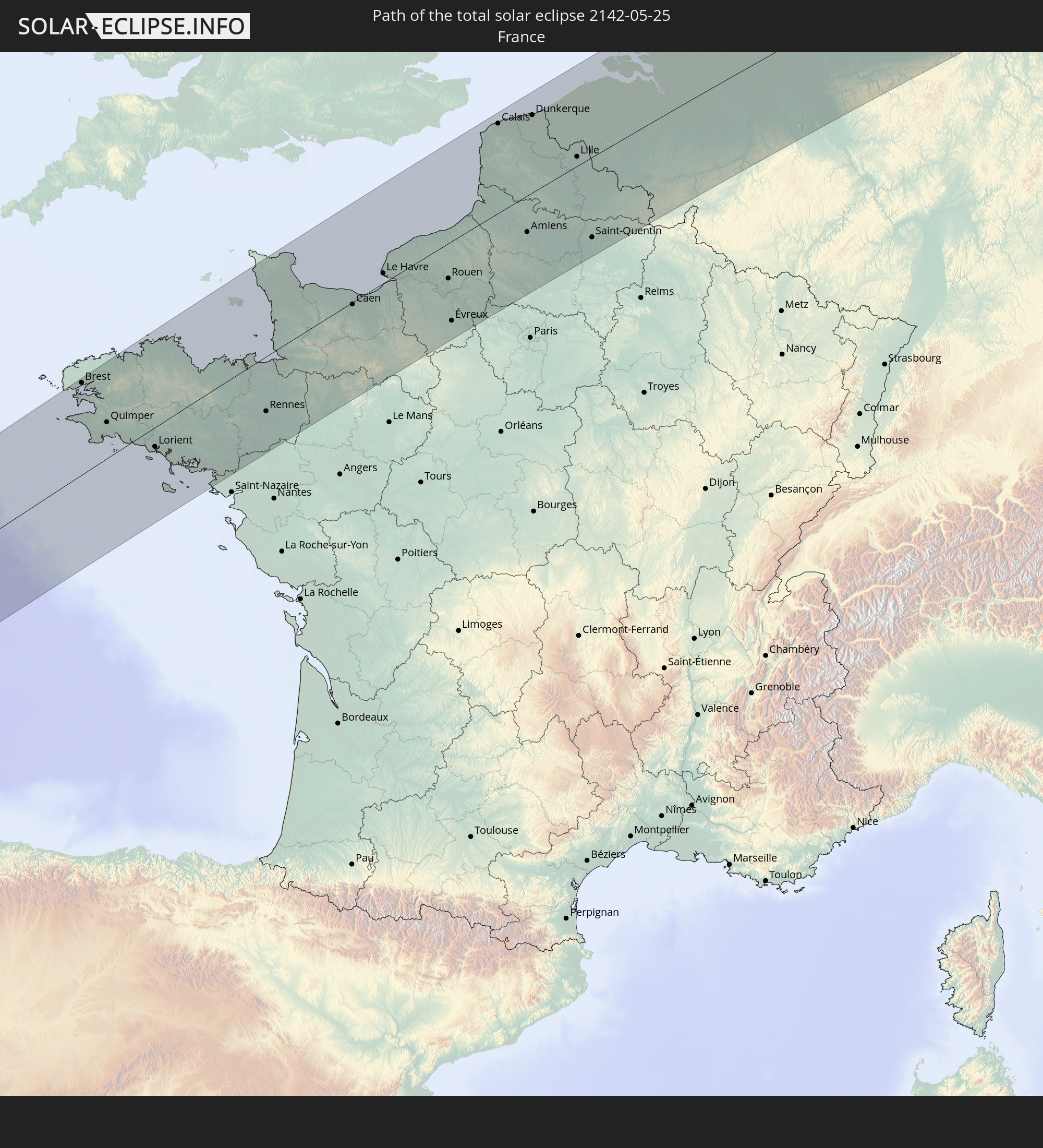 Frankreich
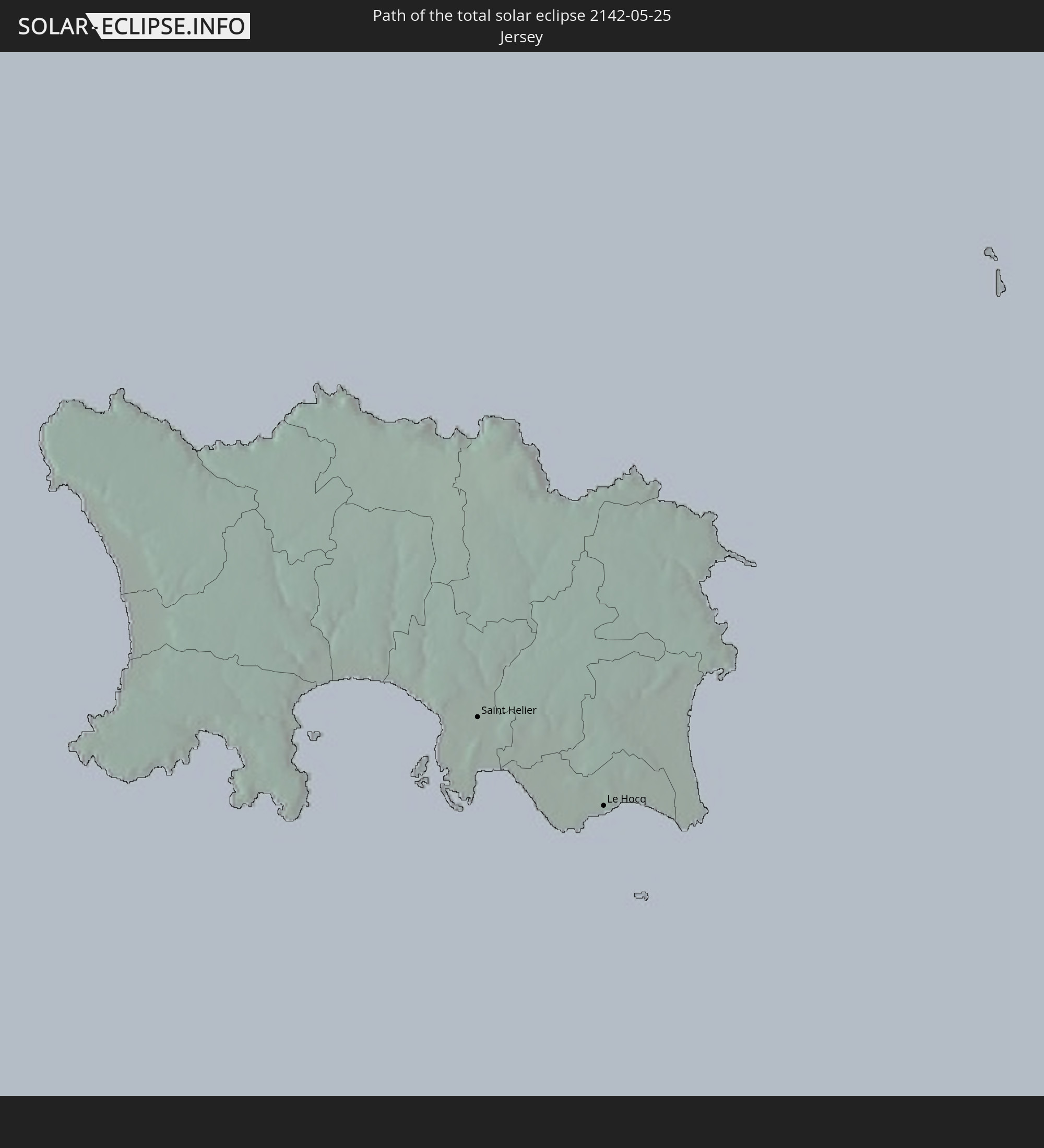 Jersey
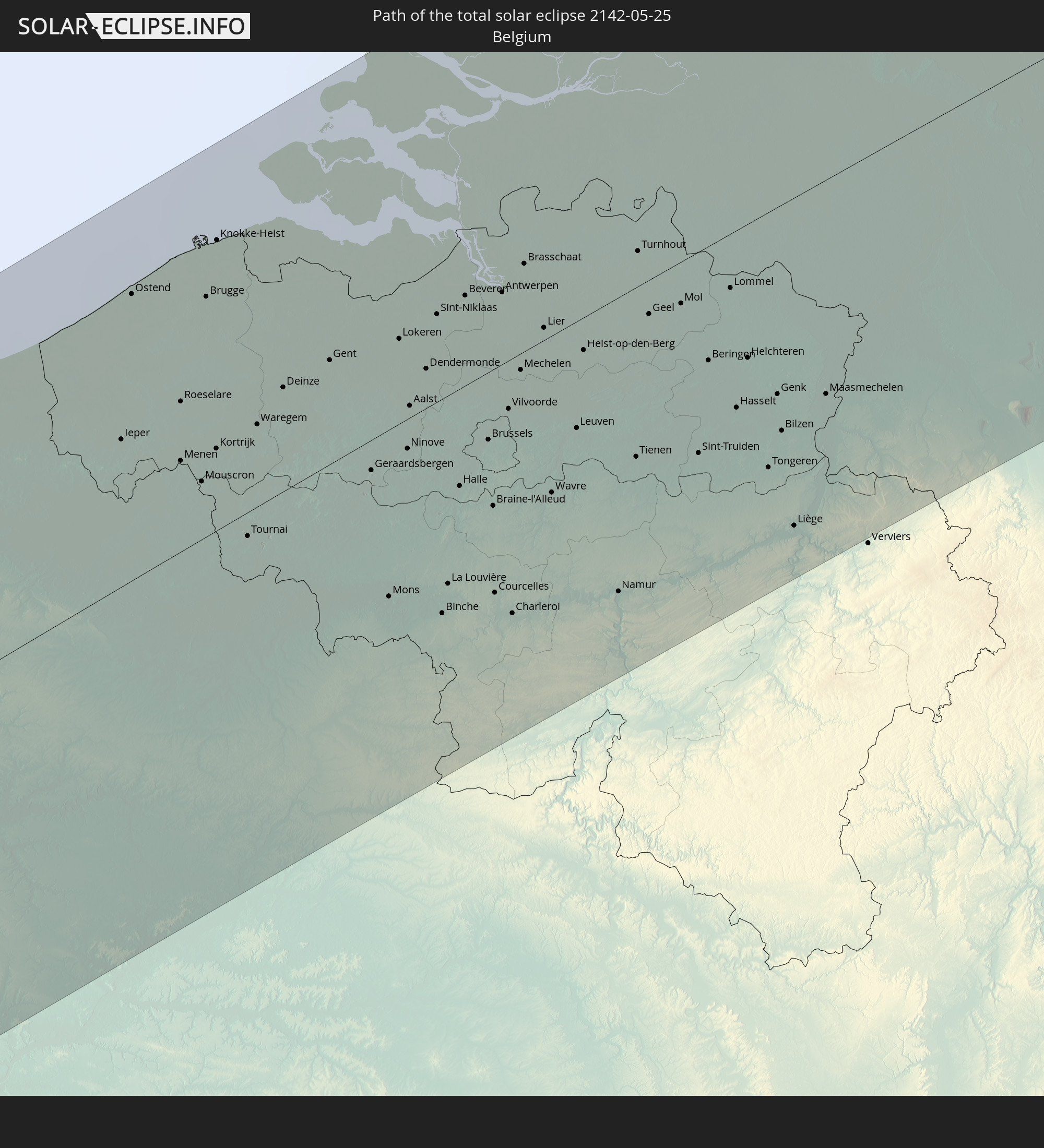 Belgien
 Niederlande
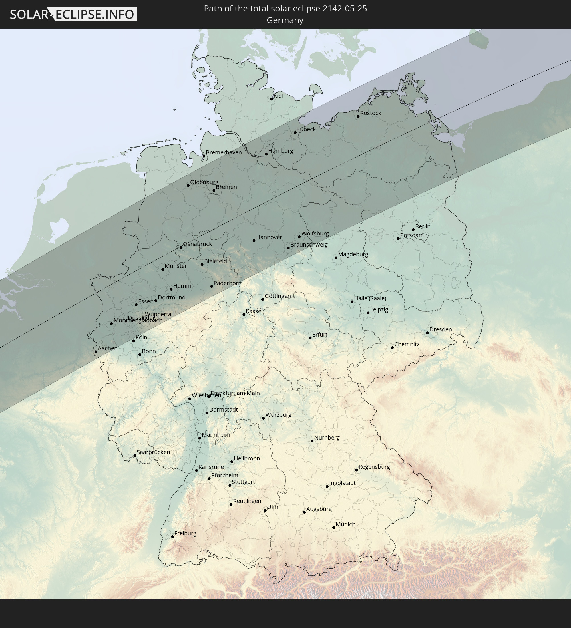 Deutschland
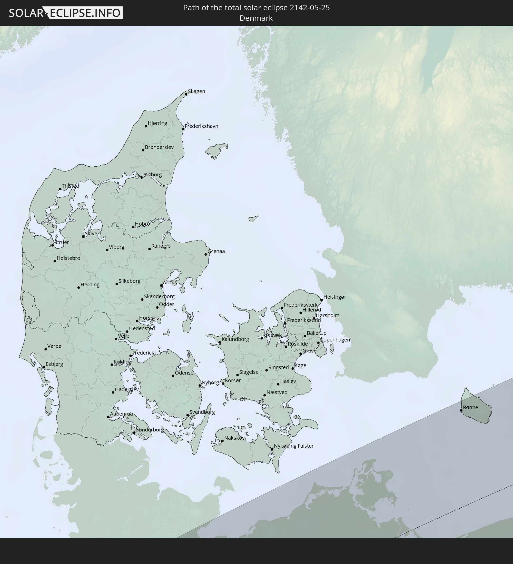 Dänemark
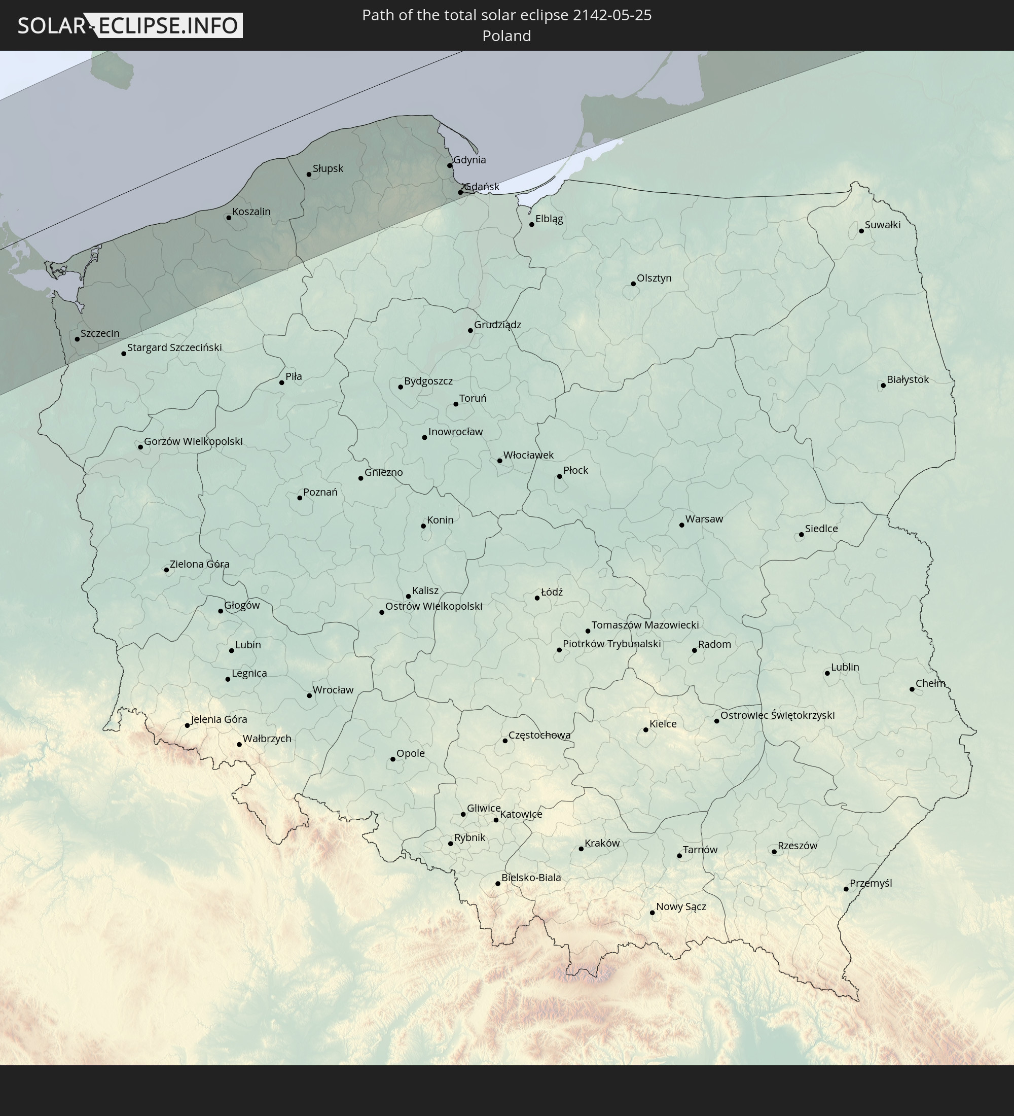 Polen
Polen
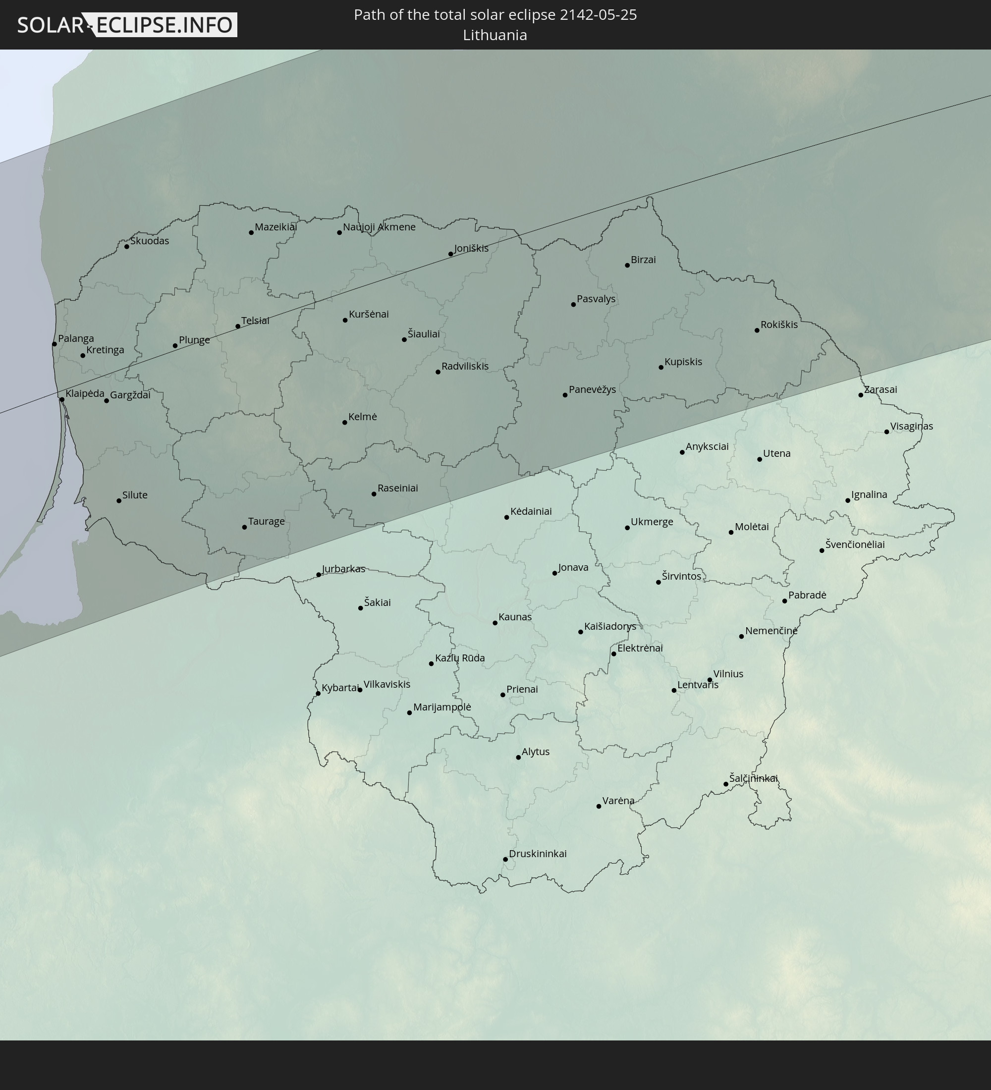 Litauen
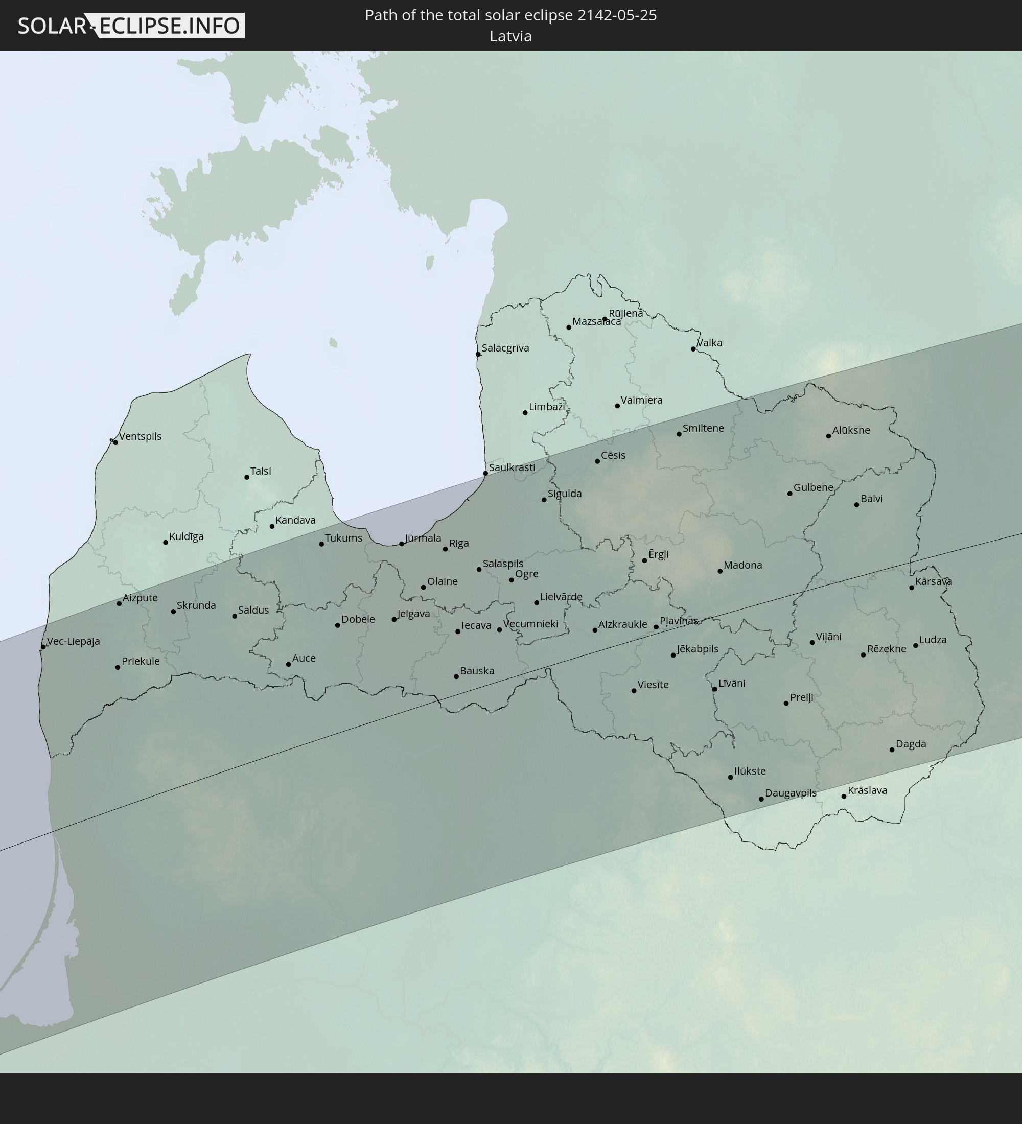 Lettland
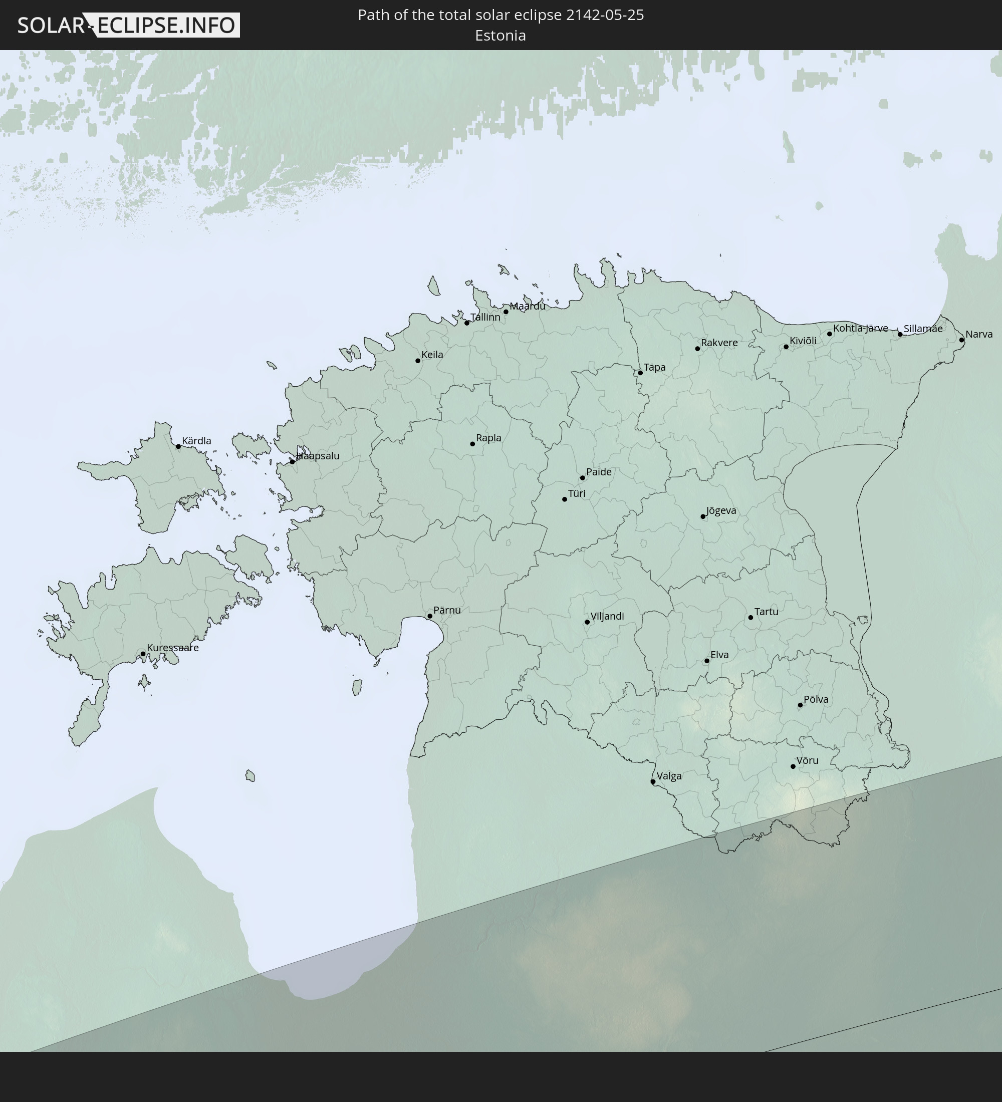 Estland
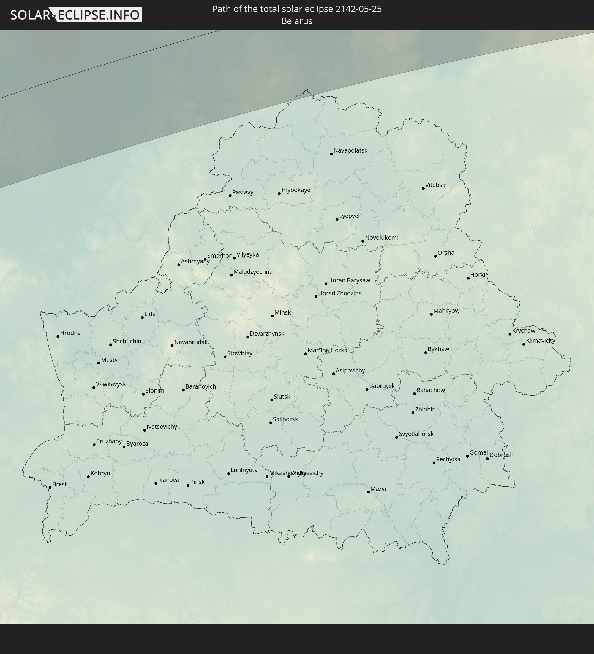 Weißrussland
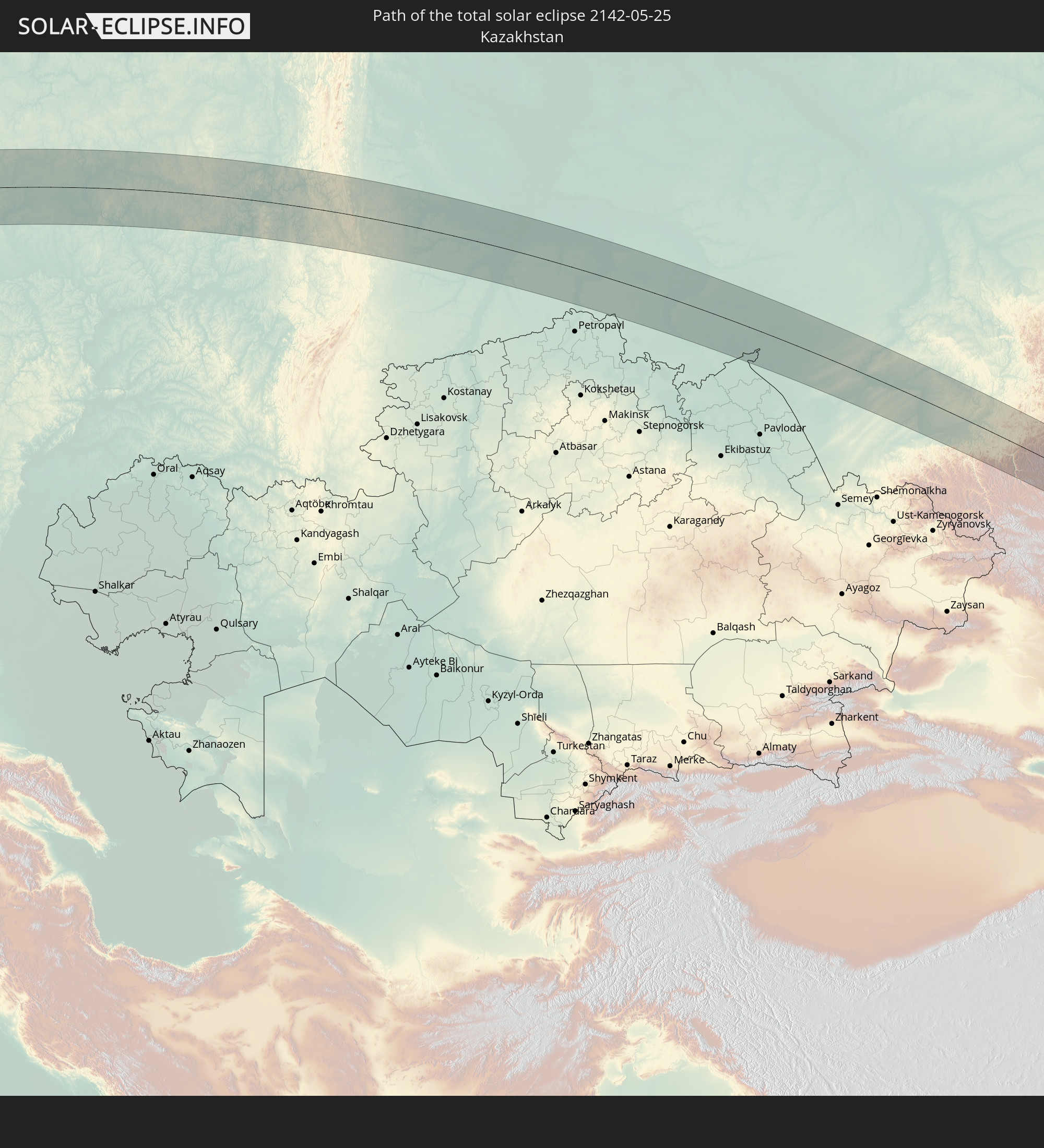 Kasachstan
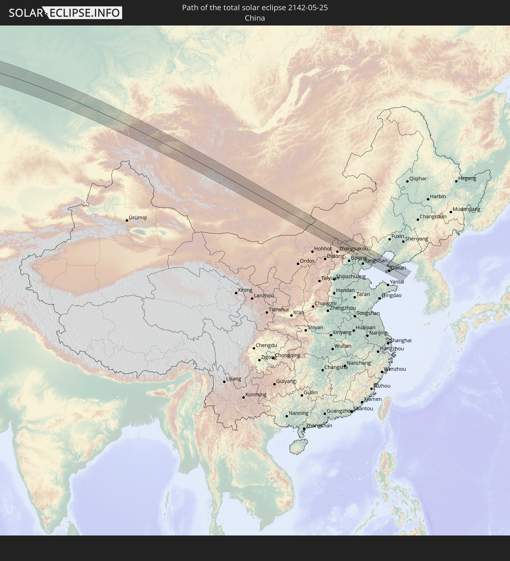 Volksrepublik China
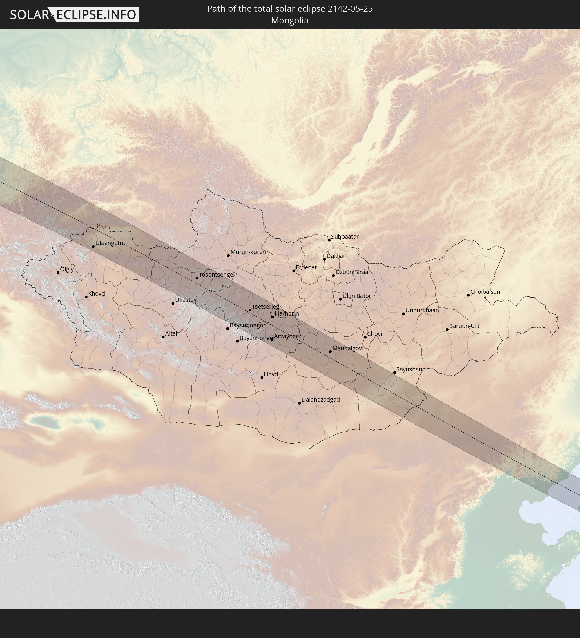 Mongolei
In den folgenden Ländern ist die Sonnenfinsternis partiell zu sehen
 Russland
 Vereinigte Staaten
 Kanada
 Grönland
 Saint-Pierre und Miquelon
 Portugal
 Kap Verde
 Island
 Spanien
 Senegal
 Mauretanien
 Gambia
 Guinea-Bissau
 Guinea
 Sierra Leone
 Marokko
 Mali
Mali
 Liberia
 Irland
 Spitzbergen
 Algerien
 Vereinigtes Königreich
 Elfenbeinküste
 Färöer
 Burkina Faso
 Gibraltar
 Frankreich
 Isle of Man
 Ghana
Ghana
 Guernsey
 Jersey
 Togo
Togo
 Niger
Niger
 Benin
Benin
 Andorra
 Belgien
 Nigeria
 Niederlande
 Norwegen
 Luxemburg
 Deutschland
 Schweiz
 Italien
 Monaco
 Tunesien
 Dänemark
 Libyen
 Liechtenstein
 Österreich
 Schweden
 Tschechien
 San Marino
 Vatikanstadt
 Slowenien
 Tschad
 Kroatien
 Polen
Polen
 Malta
Malta
 Bosnien und Herzegowina
 Ungarn
 Slowakei
 Montenegro
 Serbien
 Albanien
 Åland Islands
 Griechenland
 Rumänien
 Mazedonien
 Finnland
 Litauen
 Lettland
 Estland
 Sudan
Sudan
 Ukraine
 Bulgarien
 Weißrussland
 Ägypten
 Türkei
 Moldawien
 Republik Zypern
 Staat Palästina
 Israel
 Saudi-Arabien
 Jordanien
 Libanon
 Syrien
 Irak
Irak
 Georgien
 Armenien
 Iran
Iran
 Aserbaidschan
 Kasachstan
 Kuwait
 Bahrain
 Katar
Katar
 Vereinigte Arabische Emirate
 Oman
Oman
 Turkmenistan
 Usbekistan
 Afghanistan
 Pakistan
 Tadschikistan
 Indien
 Kirgisistan
 Volksrepublik China
 Nepal
Nepal
 Mongolei
 Bangladesch
 Bhutan
 Myanmar
 Thailand
 Laos
Laos
 Vietnam
 Kambodscha
 Nordkorea
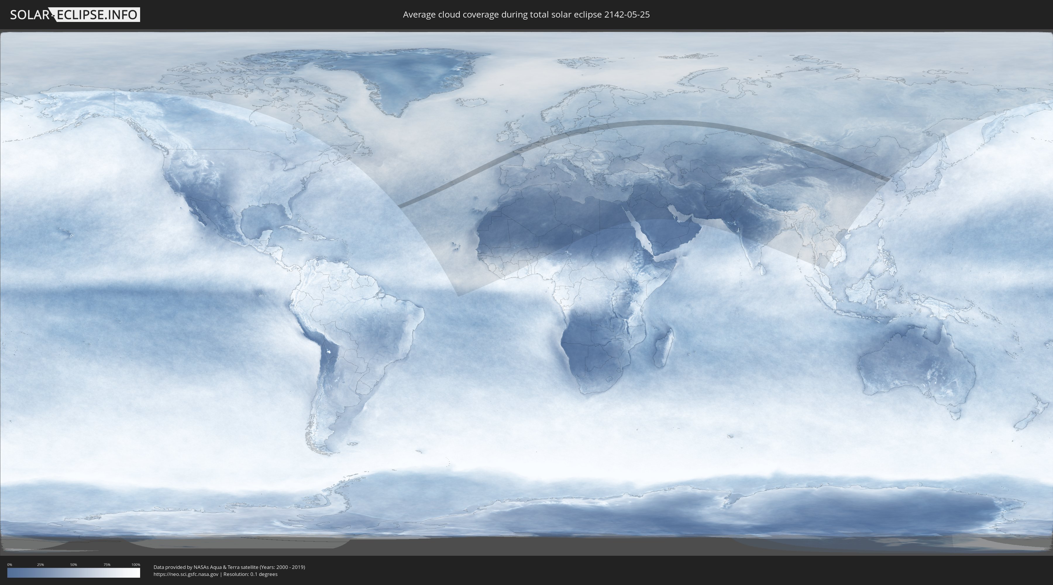
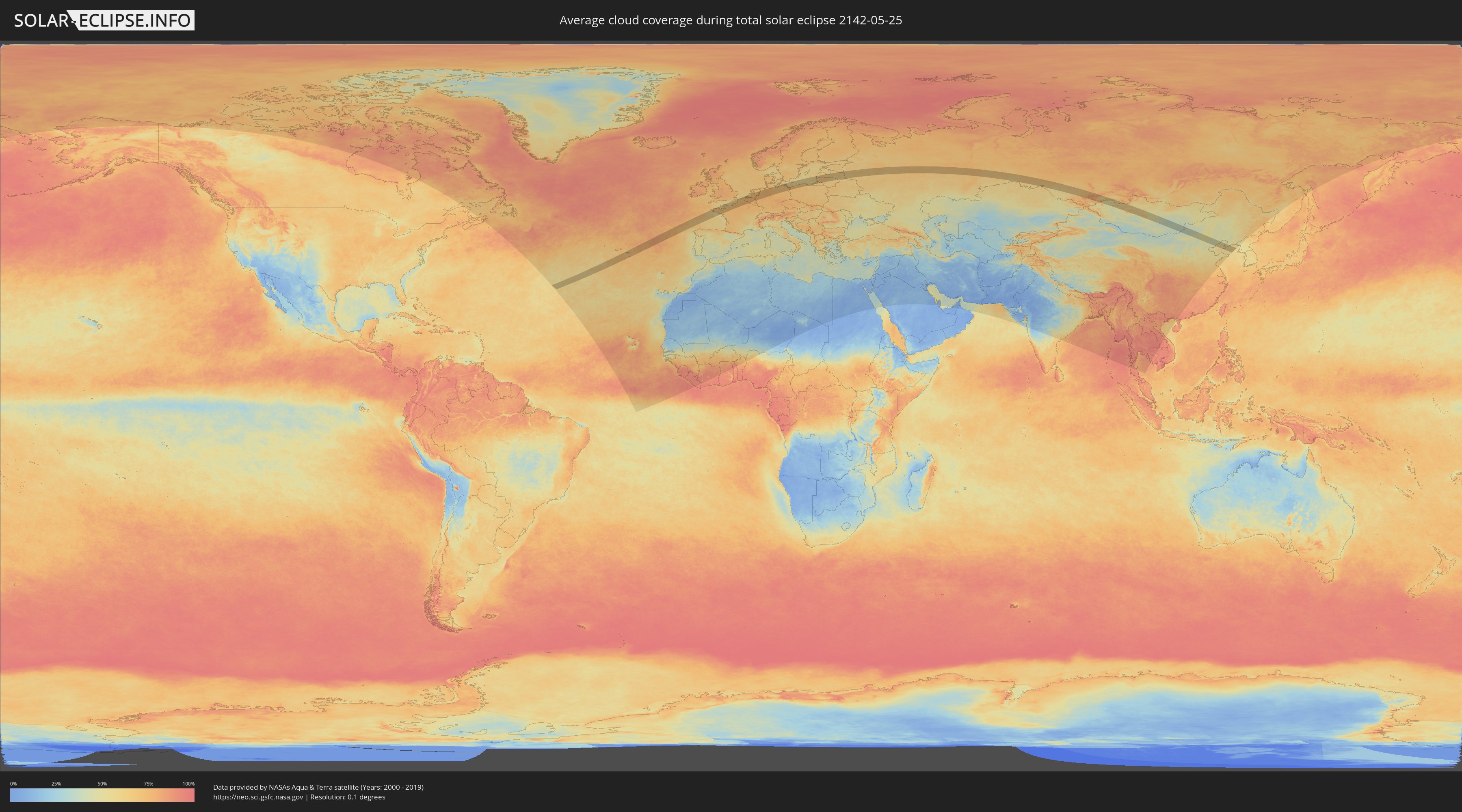
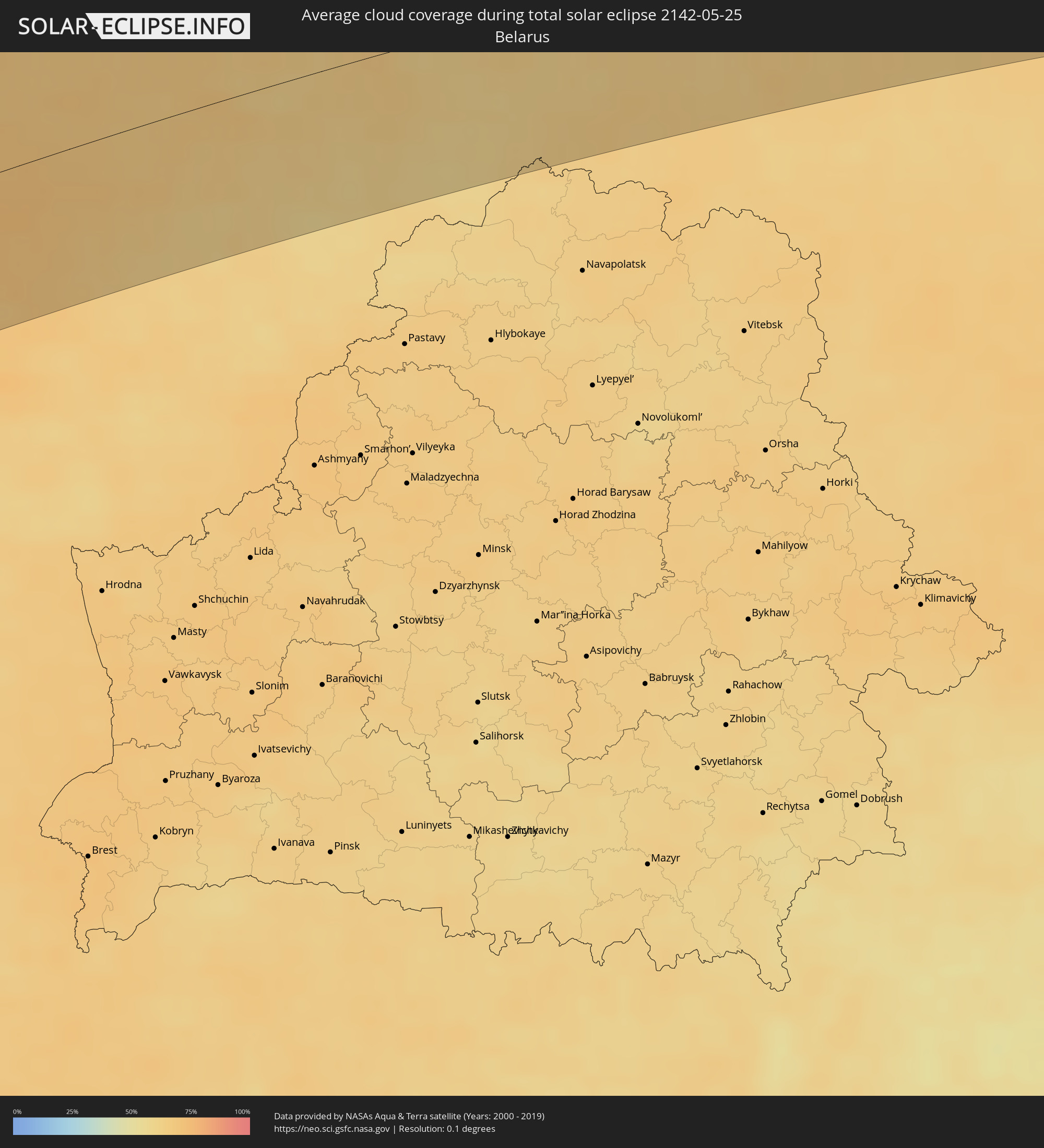
Wie wird das Wetter während der totalen Sonnenfinsternis am 25.05.2142?
Wo ist der beste Ort, um die totale Sonnenfinsternis vom 25.05.2142 zu beobachten?
Die folgenden Karten zeigen die durchschnittliche Bewölkung für den Tag, an dem die totale Sonnenfinsternis
stattfindet. Mit Hilfe der Karten lässt sich der Ort entlang des Finsternispfades eingrenzen,
der die besten Aussichen auf einen klaren wolkenfreien Himmel bietet.
Trotzdem muss man immer lokale Gegenenheiten beachten und sollte sich genau über das Wetter an seinem
gewählten Beobachtungsort informieren.
Die Daten stammen von den beiden NASA-Satelliten
AQUA und TERRA
und wurden über einen Zeitraum von 19 Jahren (2000 - 2019) gemittelt.
Detaillierte Länderkarten
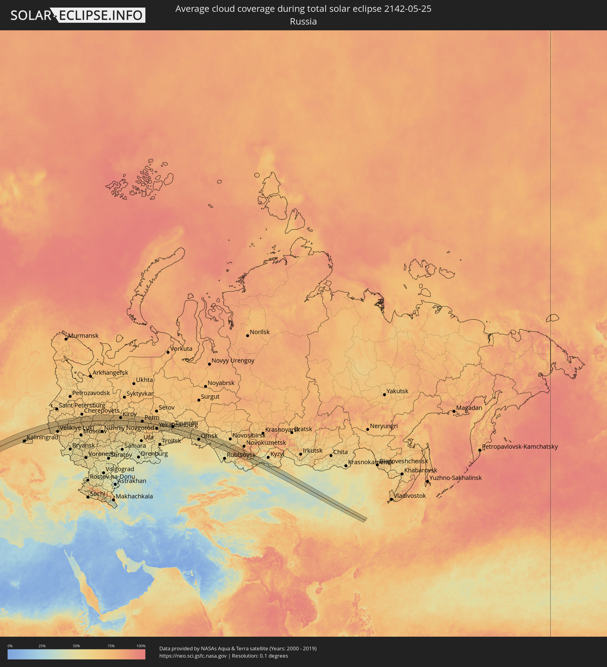 Russland
 Portugal
 Frankreich
 Jersey
 Belgien
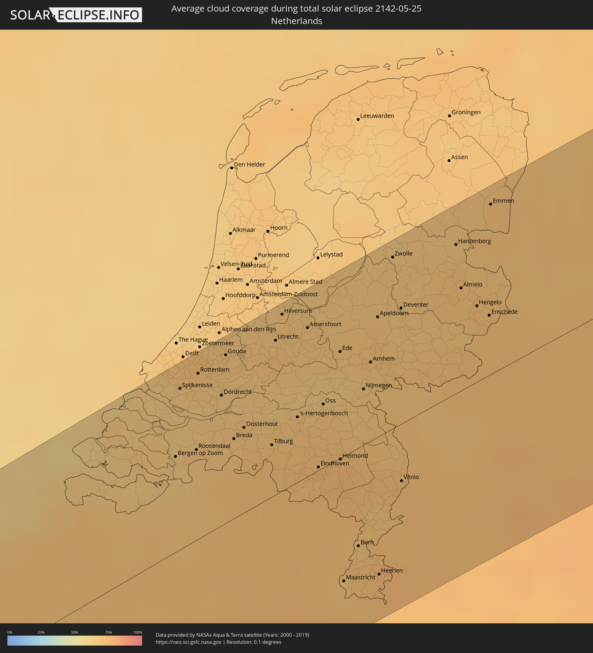 Niederlande
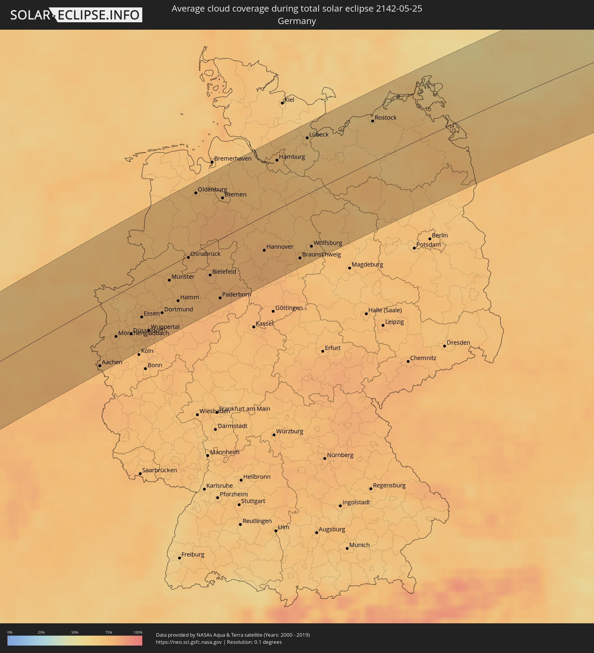 Deutschland
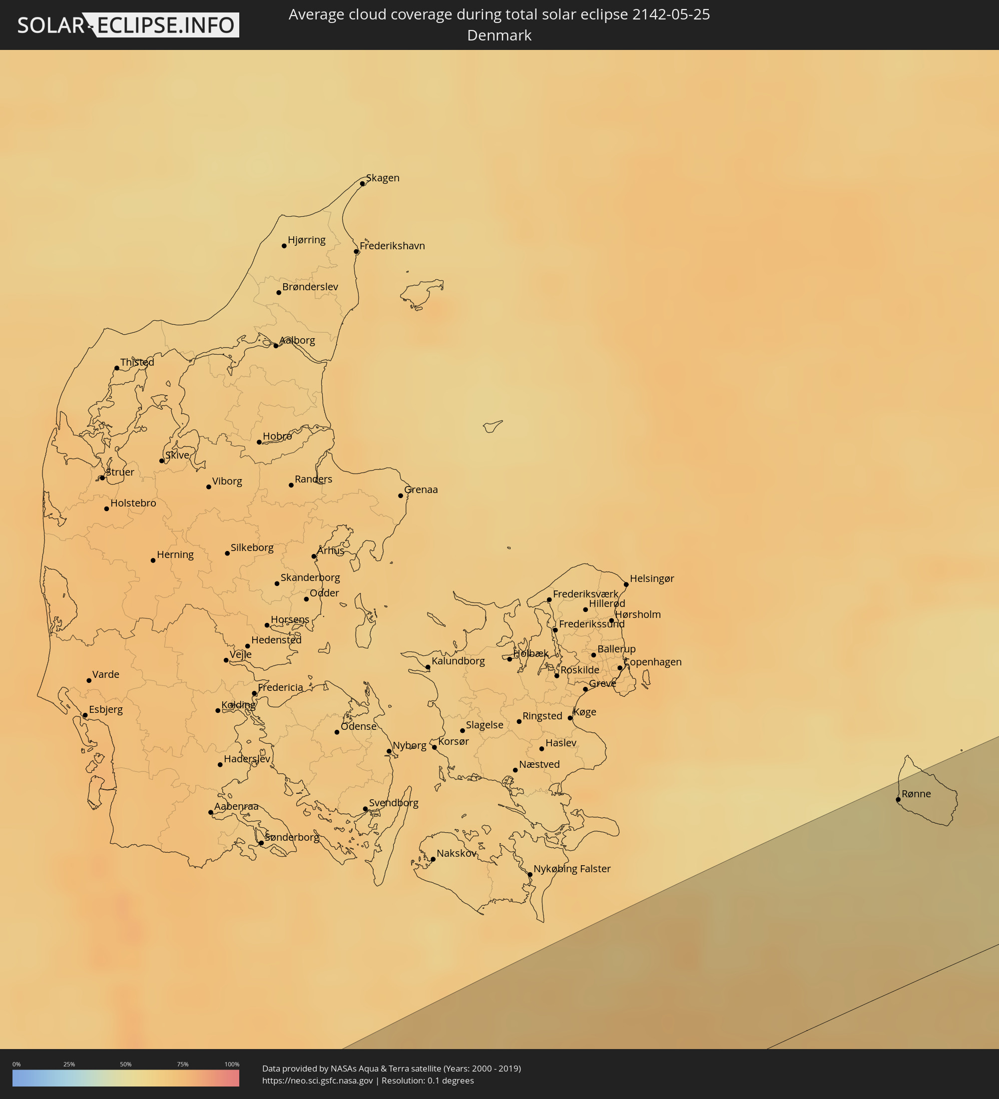 Dänemark
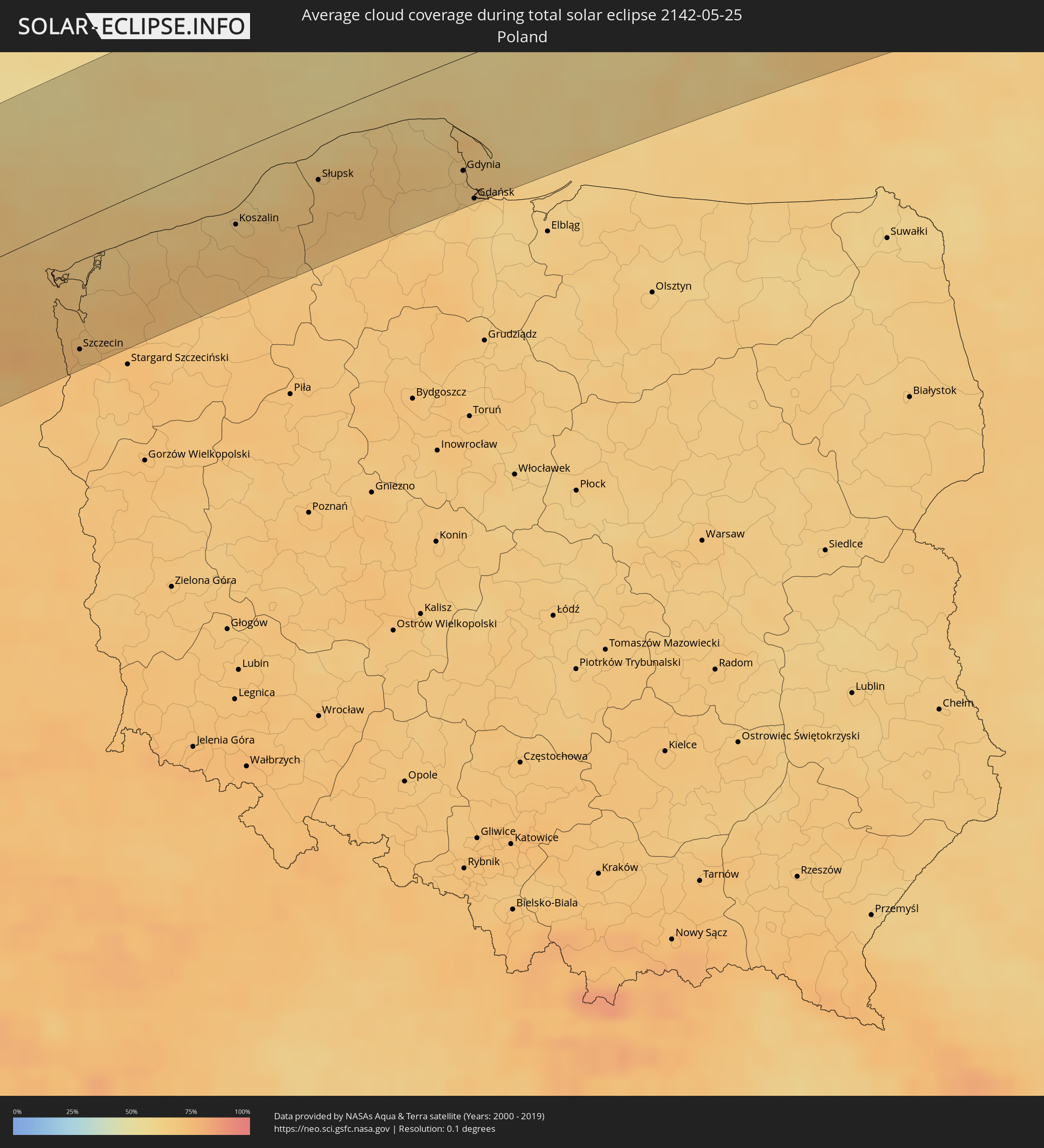 Polen
Polen
 Litauen
 Lettland
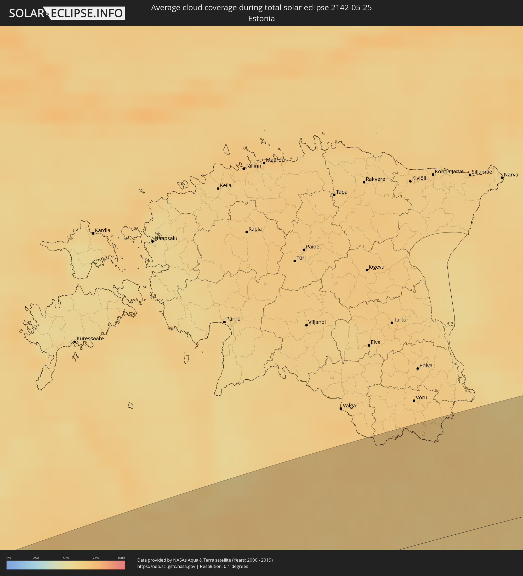 Estland
 Weißrussland
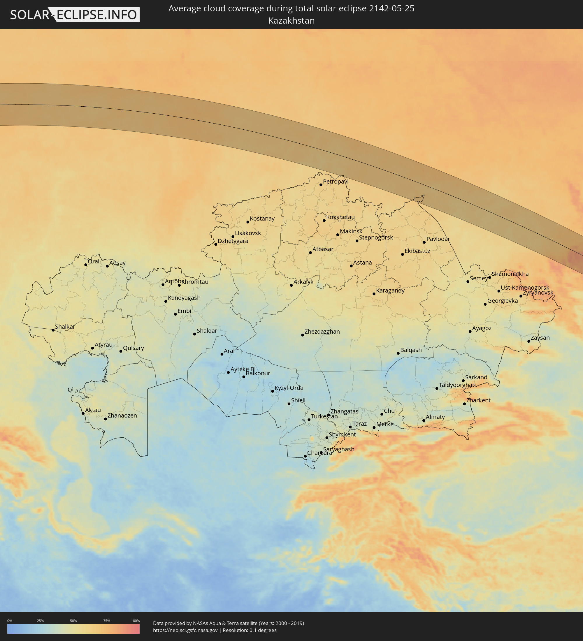 Kasachstan
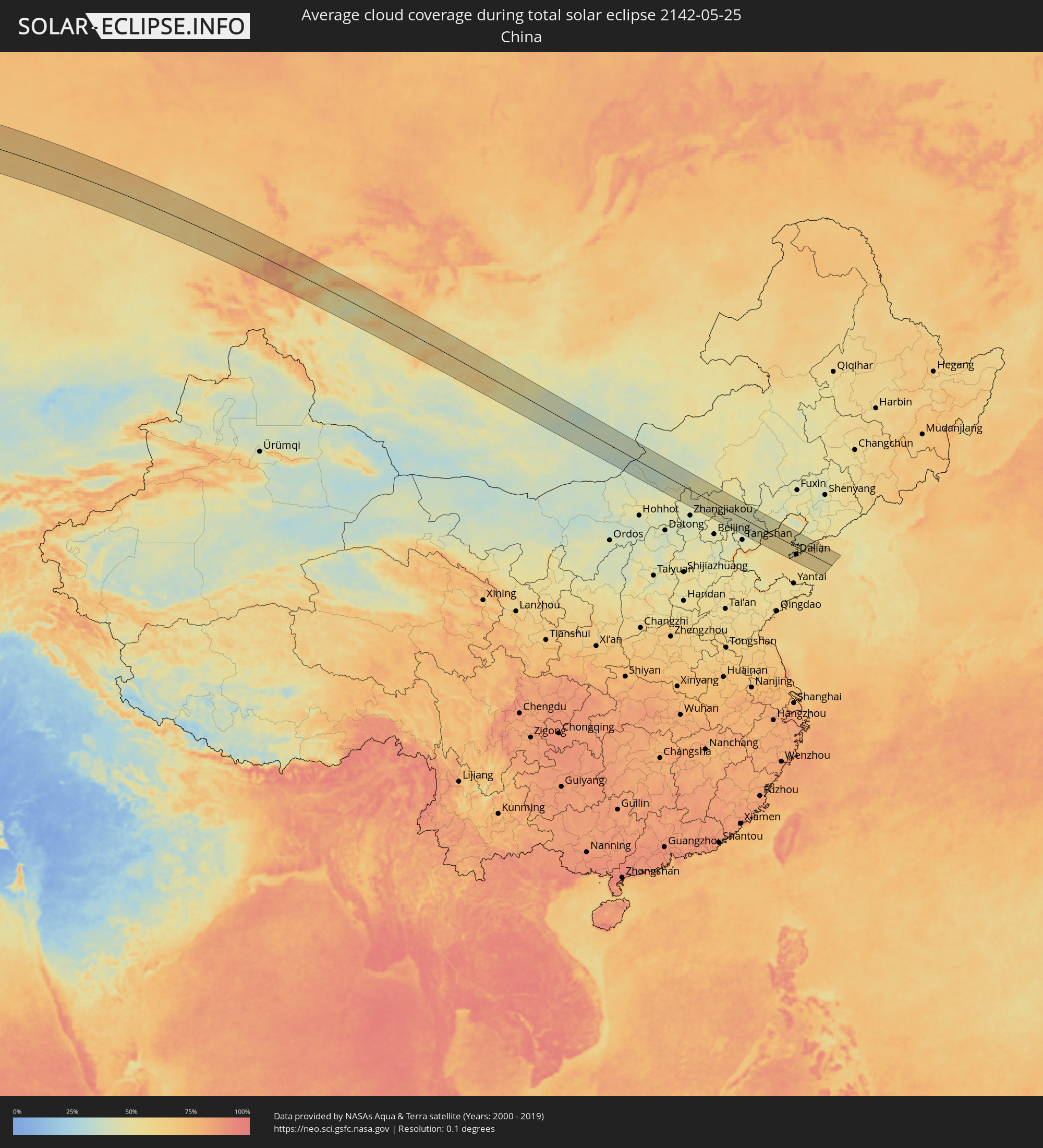 Volksrepublik China
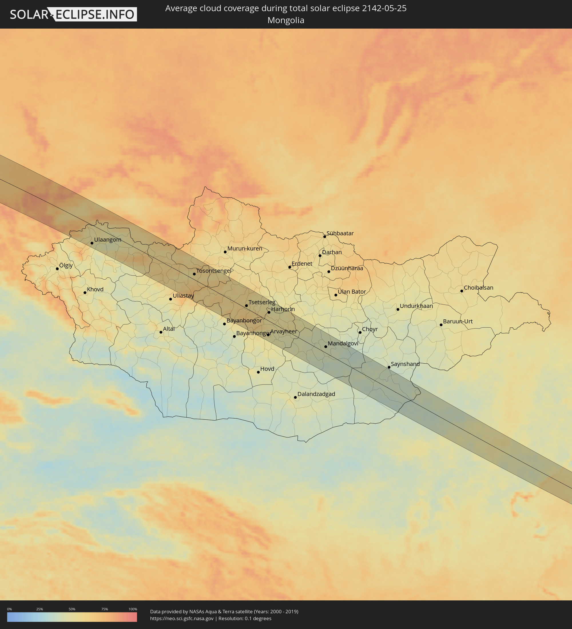 Mongolei
Orte im Finsternispfad
Die nachfolgene Tabelle zeigt Städte und Orte mit mehr als 5.000 Einwohnern, die sich im Finsternispfad befinden. Städte mit mehr als 100.000 Einwohnern sind dick gekennzeichnet. Mit einem Klick auf den Ort öffnet sich eine Detailkarte die die Lage des jeweiligen Ortes zusammen mit dem Verlauf der zentralen Finsternis präsentiert.
| Ort | Typ | Dauer der Verfinsterung | Ortszeit bei maximaler Verfinsterung | Entfernung zur Zentrallinie | Ø Bewölkung |
|
Arrifes, Azores
|
total | - | 07:09:55 UTC-01:00 | 49 km | 79% |
|
Ponta Delgada, Azores
|
total | - | 07:09:52 UTC-01:00 | 45 km | 75% |
|
Rosto de Cão, Azores
|
total | - | 07:09:54 UTC-01:00 | 46 km | 79% |
|
Rabo de Peixe, Azores
|
total | - | 07:09:58 UTC-01:00 | 50 km | 80% |
|
Vila Franca do Campo, Azores
|
total | - | 07:09:52 UTC-01:00 | 40 km | 77% |
|
Brest, Brittany
|
total | - | 09:35:32 UTC+01:00 | 88 km | 71% |
|
Quimper, Brittany
|
total | - | 09:35:09 UTC+01:00 | 37 km | 69% |
|
Lorient, Brittany
|
total | - | 09:35:17 UTC+01:00 | 19 km | 65% |
|
Saint-Brieuc, Brittany
|
total | - | 09:37:01 UTC+01:00 | 29 km | 72% |
|
Vannes, Brittany
|
total | - | 09:35:38 UTC+01:00 | 52 km | 67% |
|
Saint Helier, St Helier
|
total | - | 08:38:40 UTC+00:00 | 67 km | 61% |
|
Le Hocq, St Clement
|
total | - | 08:38:40 UTC+00:00 | 63 km | 61% |
|
Rennes, Brittany
|
total | - | 09:37:14 UTC+01:00 | 52 km | 72% |
|
Caen, Normandy
|
total | - | 09:40:06 UTC+01:00 | 11 km | 72% |
|
Le Havre, Normandy
|
total | - | 09:41:00 UTC+01:00 | 17 km | 65% |
|
Rouen, Normandy
|
total | - | 09:41:47 UTC+01:00 | 35 km | 74% |
|
Évreux, Normandy
|
total | - | 09:41:09 UTC+01:00 | 76 km | 75% |
|
Calais, Hauts-de-France
|
total | - | 09:44:54 UTC+01:00 | 83 km | 67% |
|
Beauvais, Hauts-de-France
|
total | - | 09:42:40 UTC+01:00 | 71 km | 72% |
|
Amiens, Hauts-de-France
|
total | - | 09:43:37 UTC+01:00 | 34 km | 73% |
|
Dunkerque, Hauts-de-France
|
total | - | 09:45:30 UTC+01:00 | 71 km | 70% |
|
Ostend, Flanders
|
total | - | 09:46:18 UTC+01:00 | 69 km | 64% |
|
Lille, Hauts-de-France
|
total | - | 09:45:30 UTC+01:00 | 9 km | 72% |
|
Brugge, Flanders
|
total | - | 09:46:33 UTC+01:00 | 59 km | 69% |
|
Kortrijk, Flanders
|
total | - | 09:46:00 UTC+01:00 | 21 km | 73% |
|
Saint-Quentin, Hauts-de-France
|
total | - | 09:44:28 UTC+01:00 | 75 km | 75% |
|
Gent, Flanders
|
total | - | 09:46:46 UTC+01:00 | 26 km | 74% |
|
Mons, Wallonia
|
total | - | 09:46:04 UTC+01:00 | 43 km | 73% |
|
Aalst, Flanders
|
total | - | 09:46:54 UTC+01:00 | 5 km | 73% |
|
Sint-Niklaas, Flanders
|
total | - | 09:47:22 UTC+01:00 | 27 km | 72% |
|
La Louvière, Wallonia
|
total | - | 09:46:20 UTC+01:00 | 47 km | 73% |
|
Brussels, Brussels Capital
|
total | - | 09:47:04 UTC+01:00 | 25 km | 73% |
|
Antwerpen, Flanders
|
total | - | 09:47:42 UTC+01:00 | 17 km | 72% |
|
Charleroi, Wallonia
|
total | - | 09:46:28 UTC+01:00 | 62 km | 74% |
|
Mechelen, Flanders
|
total | - | 09:47:28 UTC+01:00 | 6 km | 73% |
|
Rotterdam, South Holland
|
total | - | 09:48:52 UTC+01:00 | 83 km | 69% |
|
Dordrecht, South Holland
|
total | - | 09:48:52 UTC+01:00 | 66 km | 70% |
|
Leuven, Flanders
|
total | - | 09:47:27 UTC+01:00 | 26 km | 73% |
|
Breda, North Brabant
|
total | - | 09:48:38 UTC+01:00 | 40 km | 71% |
|
Namur, Wallonia
|
total | - | 09:46:59 UTC+01:00 | 72 km | 76% |
|
Tilburg, North Brabant
|
total | - | 09:48:53 UTC+01:00 | 31 km | 73% |
|
Utrecht, Utrecht
|
total | - | 09:49:44 UTC+01:00 | 78 km | 74% |
|
's-Hertogenbosch, North Brabant
|
total | - | 09:49:19 UTC+01:00 | 33 km | 72% |
|
Hasselt, Flanders
|
total | - | 09:48:10 UTC+01:00 | 43 km | 75% |
|
Amersfoort, Utrecht
|
total | - | 09:50:06 UTC+01:00 | 74 km | 72% |
|
Eindhoven, North Brabant
|
total | - | 09:49:05 UTC+01:00 | 2 km | 75% |
|
Liège, Wallonia
|
total | - | 09:47:56 UTC+01:00 | 80 km | 75% |
|
Maastricht, Limburg
|
total | - | 09:48:23 UTC+01:00 | 66 km | 71% |
|
Born, Limburg
|
total | - | 09:48:48 UTC+01:00 | 50 km | 74% |
|
Nijmegen, Gelderland
|
total | - | 09:50:05 UTC+01:00 | 28 km | 71% |
|
Arnhem, Gelderland
|
total | - | 09:50:21 UTC+01:00 | 42 km | 70% |
|
Apeldoorn, Gelderland
|
total | - | 09:50:45 UTC+01:00 | 60 km | 72% |
|
Heerlen, Limburg
|
total | - | 09:48:44 UTC+01:00 | 70 km | 75% |
|
Aachen, North Rhine-Westphalia
|
total | - | 09:48:41 UTC+01:00 | 84 km | 74% |
|
Zwolle, Overijssel
|
total | - | 09:51:20 UTC+01:00 | 86 km | 71% |
|
Mönchengladbach, North Rhine-Westphalia
|
total | - | 09:49:40 UTC+01:00 | 56 km | 74% |
|
Krefeld, North Rhine-Westphalia
|
total | - | 09:50:03 UTC+01:00 | 49 km | 73% |
|
Duisburg, North Rhine-Westphalia
|
total | - | 09:50:23 UTC+01:00 | 43 km | 74% |
|
Düsseldorf, North Rhine-Westphalia
|
total | - | 09:50:04 UTC+01:00 | 65 km | 73% |
|
Enschede, Overijssel
|
total | - | 09:51:42 UTC+01:00 | 31 km | 74% |
|
Essen, North Rhine-Westphalia
|
total | - | 09:50:40 UTC+01:00 | 50 km | 74% |
|
Wuppertal, North Rhine-Westphalia
|
total | - | 09:50:33 UTC+01:00 | 73 km | 77% |
|
Dortmund, North Rhine-Westphalia
|
total | - | 09:51:14 UTC+01:00 | 58 km | 74% |
|
Hagen, North Rhine-Westphalia
|
total | - | 09:51:01 UTC+01:00 | 73 km | 76% |
|
Münster, North Rhine-Westphalia
|
total | - | 09:52:04 UTC+01:00 | 19 km | 74% |
|
Bielefeld, North Rhine-Westphalia
|
total | - | 09:53:08 UTC+01:00 | 46 km | 76% |
|
Bremen, Bremen
|
total | - | 09:54:56 UTC+01:00 | 54 km | 75% |
|
Hannover, Lower Saxony
|
total | - | 09:54:55 UTC+01:00 | 46 km | 76% |
|
Hamburg, Hamburg
|
total | - | 09:56:56 UTC+01:00 | 65 km | 73% |
|
Braunschweig, Lower Saxony
|
total | - | 09:55:39 UTC+01:00 | 81 km | 74% |
|
Lübeck, Schleswig-Holstein
|
total | - | 09:58:04 UTC+01:00 | 75 km | 68% |
|
Świnoujście, West Pomeranian Voivodeship
|
total | - | 10:02:07 UTC+01:00 | 24 km | 70% |
|
Szczecin, West Pomeranian Voivodeship
|
total | - | 10:01:52 UTC+01:00 | 81 km | 72% |
|
Rønne, Capital Region
|
total | - | 10:04:09 UTC+01:00 | 87 km | 57% |
|
Goleniów, West Pomeranian Voivodeship
|
total | - | 10:02:22 UTC+01:00 | 75 km | 72% |
|
Nowogard, West Pomeranian Voivodeship
|
total | - | 10:02:51 UTC+01:00 | 72 km | 73% |
|
Gryfice, West Pomeranian Voivodeship
|
total | - | 10:03:15 UTC+01:00 | 49 km | 71% |
|
Kołobrzeg, West Pomeranian Voivodeship
|
total | - | 10:04:01 UTC+01:00 | 33 km | 65% |
|
Świdwin, West Pomeranian Voivodeship
|
total | - | 10:03:46 UTC+01:00 | 79 km | 70% |
|
Białogard, West Pomeranian Voivodeship
|
total | - | 10:04:18 UTC+01:00 | 60 km | 70% |
|
Koszalin, West Pomeranian Voivodeship
|
total | - | 10:04:45 UTC+01:00 | 46 km | 67% |
|
Ustka, Pomeranian Voivodeship
|
total | - | 10:06:02 UTC+01:00 | 28 km | 64% |
|
Słupsk, Pomeranian Voivodeship
|
total | - | 10:06:06 UTC+01:00 | 42 km | 68% |
|
Bytów, Pomeranian Voivodeship
|
total | - | 10:06:19 UTC+01:00 | 81 km | 70% |
|
Lębork, Pomeranian Voivodeship
|
total | - | 10:07:04 UTC+01:00 | 49 km | 70% |
|
Wejherowo, Pomeranian Voivodeship
|
total | - | 10:07:44 UTC+01:00 | 55 km | 67% |
|
Gdynia, Pomeranian Voivodeship
|
total | - | 10:08:00 UTC+01:00 | 71 km | 65% |
|
Gdańsk, Pomeranian Voivodeship
|
total | - | 10:07:58 UTC+01:00 | 91 km | 66% |
|
Vec-Liepāja, Liepāja
|
total | - | 11:13:09 UTC+02:00 | 84 km | 60% |
|
Palanga, Klaipėda County
|
total | - | 11:12:37 UTC+02:00 | 21 km | 64% |
|
Klaipėda, Klaipėda County
|
total | - | 11:12:29 UTC+02:00 | 7 km | 66% |
|
Kretinga, Klaipėda County
|
total | - | 11:12:48 UTC+02:00 | 16 km | 67% |
|
Gargždai, Klaipėda County
|
total | - | 11:12:50 UTC+02:00 | 14 km | 66% |
|
Silute, Klaipėda County
|
total | - | 11:12:34 UTC+02:00 | 52 km | 58% |
|
Plunge, Telšiai County
|
total | - | 11:13:34 UTC+02:00 | 10 km | 70% |
|
Telsiai, Telšiai County
|
total | - | 11:14:08 UTC+02:00 | 16 km | 70% |
|
Taurage, Tauragė County
|
total | - | 11:13:30 UTC+02:00 | 78 km | 69% |
|
Mazeikiai, Telšiai County
|
total | - | 11:14:33 UTC+02:00 | 34 km | 69% |
|
Saldus, Saldus Rajons
|
total | - | 11:15:04 UTC+02:00 | 68 km | 67% |
|
Kuršėnai, Šiauliai County
|
total | - | 11:15:01 UTC+02:00 | 14 km | 71% |
|
Raseiniai, Kaunas County
|
total | - | 11:14:41 UTC+02:00 | 82 km | 68% |
|
Tukums, Tukuma Rajons
|
total | - | 11:16:09 UTC+02:00 | 87 km | 64% |
|
Dobele, Dobeles Rajons
|
total | - | 11:16:00 UTC+02:00 | 48 km | 67% |
|
Šiauliai, Šiauliai County
|
total | - | 11:15:26 UTC+02:00 | 29 km | 68% |
|
Radviliskis, Šiauliai County
|
total | - | 11:15:37 UTC+02:00 | 44 km | 67% |
|
Jelgava, Jelgava
|
total | - | 11:16:34 UTC+02:00 | 43 km | 67% |
|
Jūrmala, Jūrmala
|
total | - | 11:16:54 UTC+02:00 | 76 km | 62% |
|
Olaine, Olaine
|
total | - | 11:16:57 UTC+02:00 | 54 km | 66% |
|
Riga, Riga
|
total | - | 11:17:18 UTC+02:00 | 67 km | 65% |
|
Bauska, Bauskas Rajons
|
total | - | 11:16:57 UTC+02:00 | 17 km | 65% |
|
Panevėžys, Panevėžys
|
total | - | 11:16:36 UTC+02:00 | 67 km | 62% |
|
Salaspils, Salaspils
|
total | - | 11:17:33 UTC+02:00 | 53 km | 64% |
|
Ogre, Ogre
|
total | - | 11:17:49 UTC+02:00 | 45 km | 66% |
|
Birzai, Panevėžys
|
total | - | 11:17:30 UTC+02:00 | 26 km | 64% |
|
Cēsis, Cēsu Rajons
|
total | - | 11:19:02 UTC+02:00 | 85 km | 66% |
|
Rokiškis, Panevėžys
|
total | - | 11:18:23 UTC+02:00 | 66 km | 60% |
|
Jēkabpils, Jēkabpils Municipality
|
total | - | 11:19:09 UTC+02:00 | 18 km | 63% |
|
Daugavpils, Daugavpils municipality
|
total | - | 11:19:34 UTC+02:00 | 90 km | 60% |
|
Rēzekne, Rēzekne
|
total | - | 11:21:02 UTC+02:00 | 38 km | 62% |
|
Ludza, Ludzas Rajons
|
total | - | 11:21:35 UTC+02:00 | 39 km | 62% |
|
Pskov, Pskov
|
total | - | 12:23:12 UTC+03:00 | 90 km | 61% |
|
Rybinsk, Jaroslavl
|
total | - | 12:36:40 UTC+03:00 | 10 km | 66% |
|
Yaroslavl, Jaroslavl
|
total | - | 12:37:59 UTC+03:00 | 49 km | 69% |
|
Kostroma, Kostroma
|
total | - | 12:39:21 UTC+03:00 | 40 km | 65% |
|
Kineshma, Ivanovo
|
total | - | 12:40:57 UTC+03:00 | 80 km | 66% |
|
Kirov, Kirov
|
total | - | 12:50:05 UTC+03:00 | 45 km | 68% |
|
Glazov, Udmurtiya
|
total | - | 13:53:54 UTC+04:00 | 10 km | 67% |
|
Perm, Perm
|
total | - | 14:58:09 UTC+05:00 | 19 km | 69% |
|
Pervoural’sk, Sverdlovsk
|
total | - | 15:03:16 UTC+05:00 | 75 km | 71% |
|
Nizhniy Tagil, Sverdlovsk
|
total | - | 15:02:20 UTC+05:00 | 38 km | 71% |
|
Novoural’sk, Sverdlovsk
|
total | - | 15:03:06 UTC+05:00 | 38 km | 70% |
|
Yekaterinburg, Sverdlovsk
|
total | - | 15:04:03 UTC+05:00 | 74 km | 72% |
|
Tyumen, Tyumenskaya
|
total | - | 15:08:53 UTC+05:00 | 24 km | 66% |
|
Omsk, Omsk
|
total | - | 16:18:52 UTC+06:00 | 68 km | 66% |
|
Barnaul, Altai Krai
|
total | - | 17:28:51 UTC+07:00 | 21 km | 65% |
|
Biysk, Altai Krai
|
total | - | 17:30:56 UTC+07:00 | 28 km | 62% |
|
Ulaangom, Uvs
|
total | - | 17:38:07 UTC+07:00 | 71 km | 50% |
|
Tosontsengel, Dzabkhan
|
total | - | 17:41:52 UTC+07:00 | 24 km | 53% |
|
Tsetserleg, Arhangay
|
total | - | 18:44:19 UTC+08:00 | 14 km | 56% |
|
Arvayheer, Övörhangay
|
total | - | 18:46:12 UTC+08:00 | 58 km | 49% |
|
Kharkhorin, Övörhangay
|
total | - | 18:44:54 UTC+08:00 | 33 km | 56% |
|
Harhorin, Övörhangay
|
total | - | 18:44:53 UTC+08:00 | 34 km | 56% |
|
Mandalgovi, Middle Govĭ
|
total | - | 18:47:06 UTC+08:00 | 27 km | 42% |
|
Erenhot, Inner Mongolia
|
total | - | 18:49:33 UTC+08:00 | 47 km | 41% |
|
Chengde, Hebei
|
total | - | 18:51:35 UTC+08:00 | 18 km | 44% |
|
Songling, Hebei
|
total | - | 18:52:15 UTC+08:00 | 35 km | 43% |
|
Changli, Hebei
|
total | - | 18:52:38 UTC+08:00 | 57 km | 50% |
|
Beidaihehaibin, Hebei
|
total | - | 18:52:23 UTC+08:00 | 36 km | 62% |
|
Qinhuangdao, Hebei
|
total | - | 18:52:15 UTC+08:00 | 25 km | 61% |
|
Shanhaiguan, Hebei
|
total | - | 18:52:07 UTC+08:00 | 23 km | 53% |
|
Lüshun, Liaoning
|
total | - | 18:52:54 UTC+08:00 | 61 km | 60% |
|
Dalian, Liaoning
|
total | - | 18:52:39 UTC+08:00 | 42 km | 58% |
|
Dalianwan, Liaoning
|
total | - | 18:52:30 UTC+08:00 | 28 km | 60% |
|
Jinzhou, Liaoning
|
total | - | 18:52:25 UTC+08:00 | 25 km | 54% |
|
Pulandian, Liaoning
|
total | - | 18:52:01 UTC+08:00 | 30 km | 51% |
|
Wafangdian, Liaoning
|
total | - | 18:51:45 UTC+08:00 | 49 km | 51% |