Totale Sonnenfinsternis vom 24.08.2435
| Wochentag: | Freitag |
| Maximale Dauer der Verfinsterung: | 04m35s |
| Maximale Breite des Finsternispfades: | 304 km |
| Saroszyklus: | 142 |
| Bedeckungsgrad: | 100% |
| Magnitude: | 1.0684 |
| Gamma: | 0.6875 |
Wo kann man die Sonnenfinsternis vom 24.08.2435 sehen?
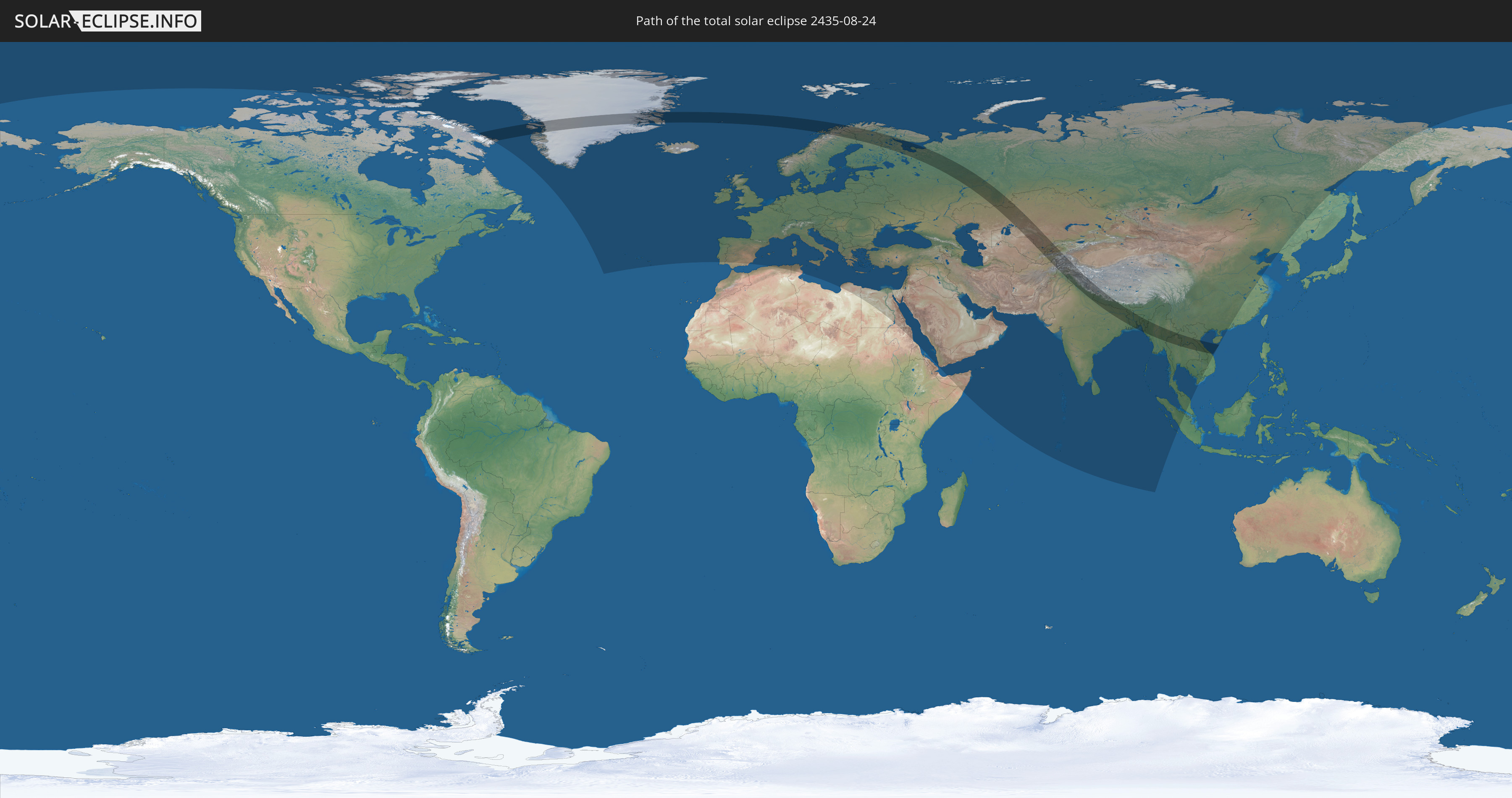
Die Sonnenfinsternis am 24.08.2435 kann man in 102 Ländern als partielle Sonnenfinsternis beobachten.
Der Finsternispfad verläuft durch 21 Länder. Nur in diesen Ländern ist sie als totale Sonnenfinsternis zu sehen.
In den folgenden Ländern ist die Sonnenfinsternis total zu sehen
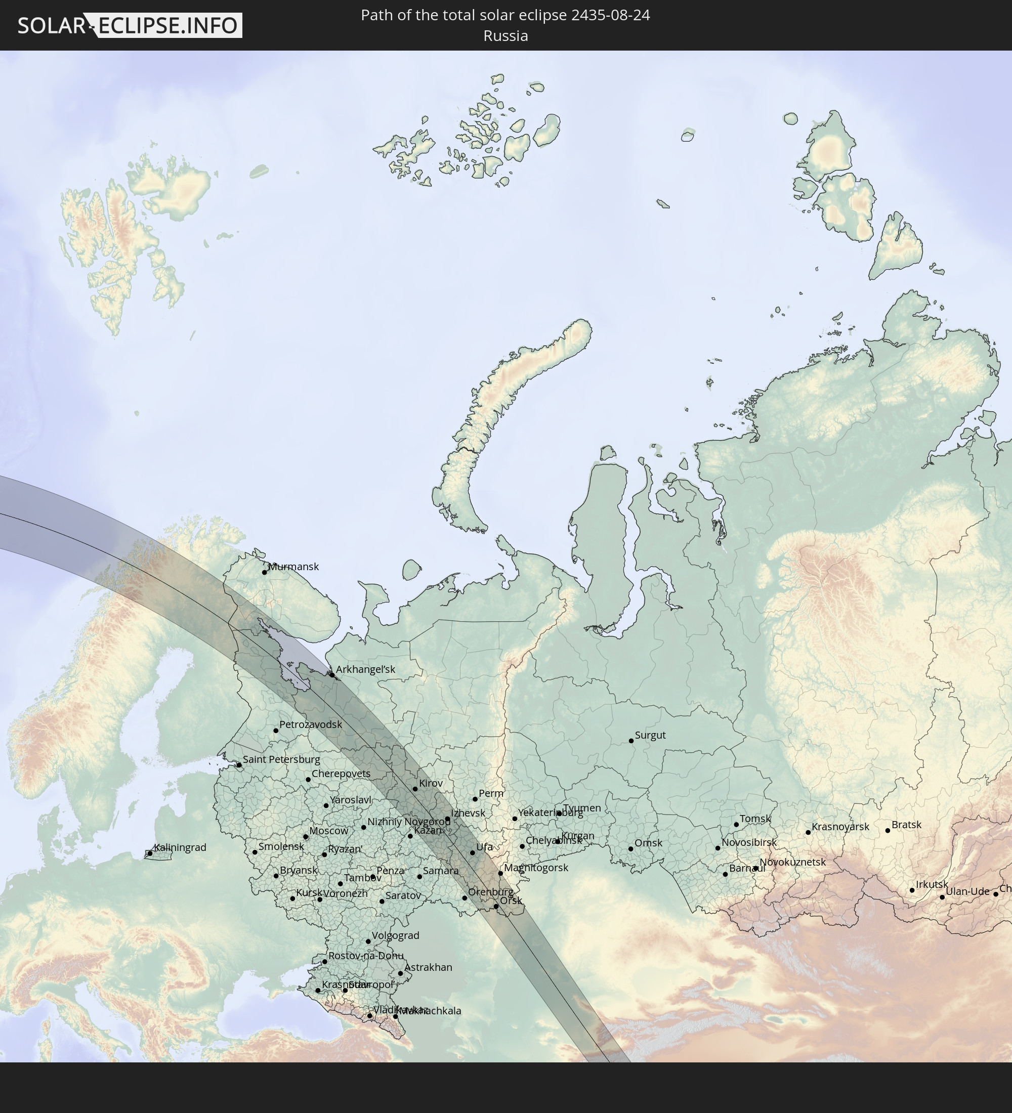 Russland
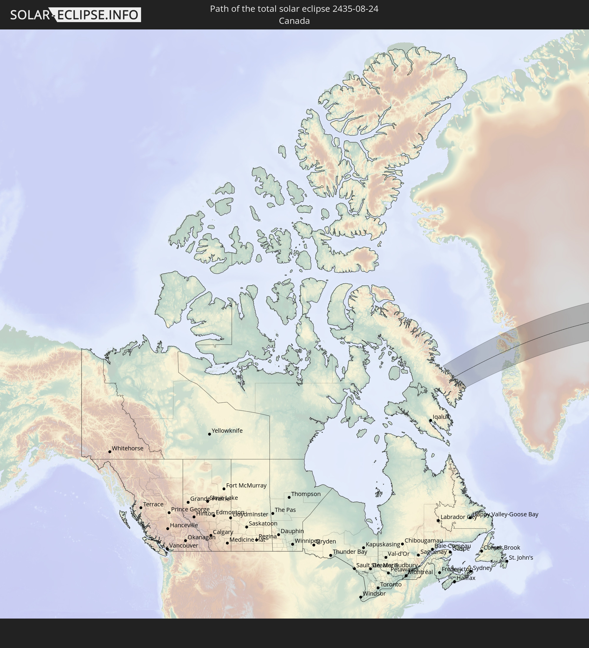 Kanada
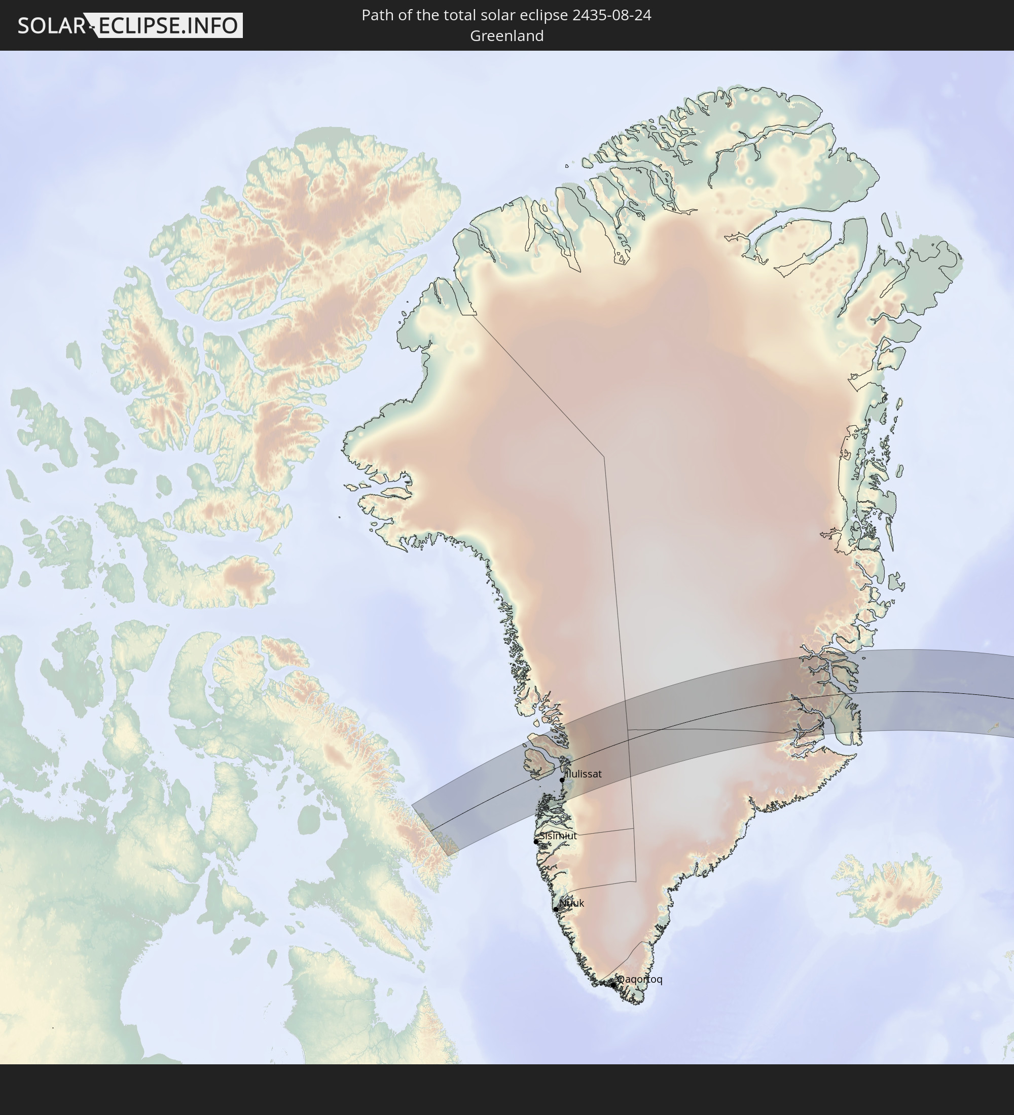 Grönland
 Spitzbergen
 Norwegen
 Schweden
 Finnland
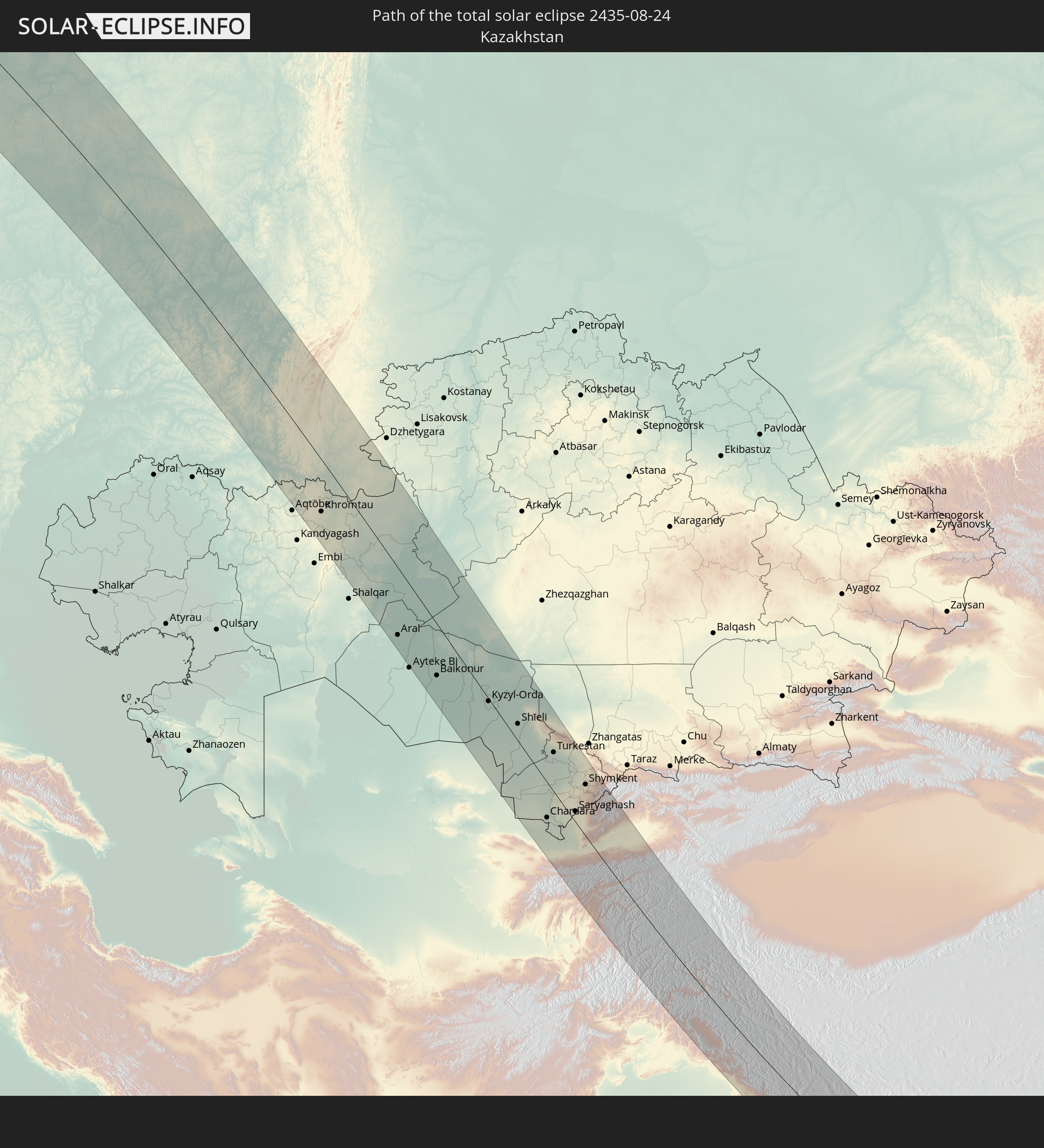 Kasachstan
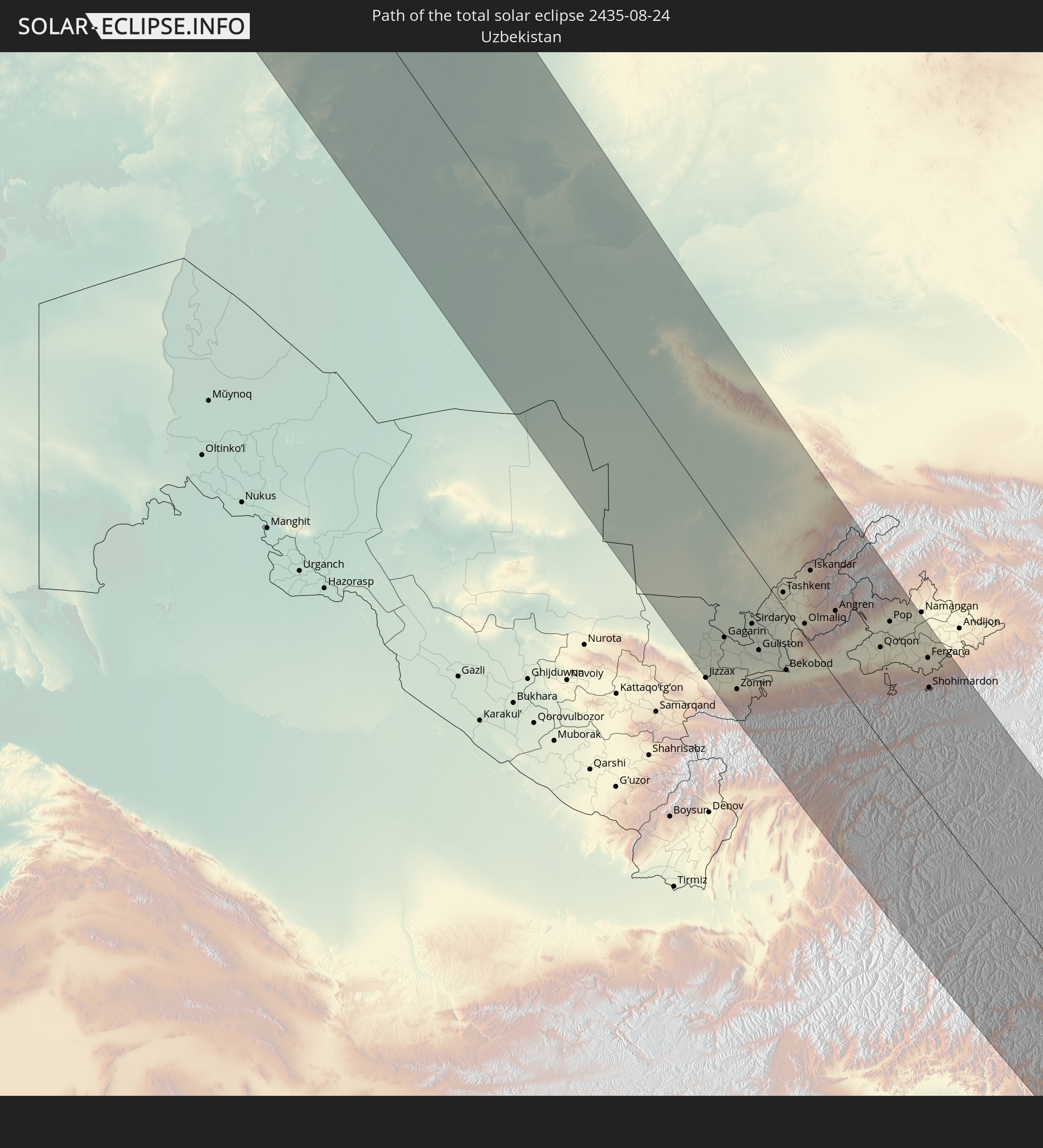 Usbekistan
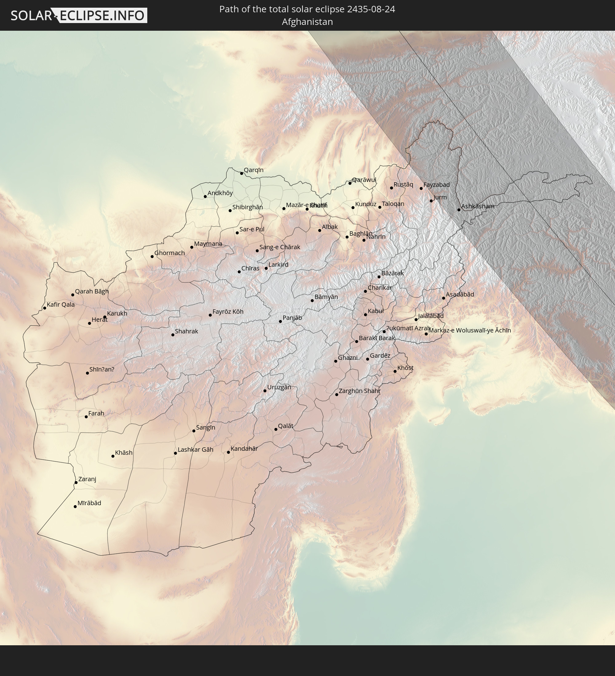 Afghanistan
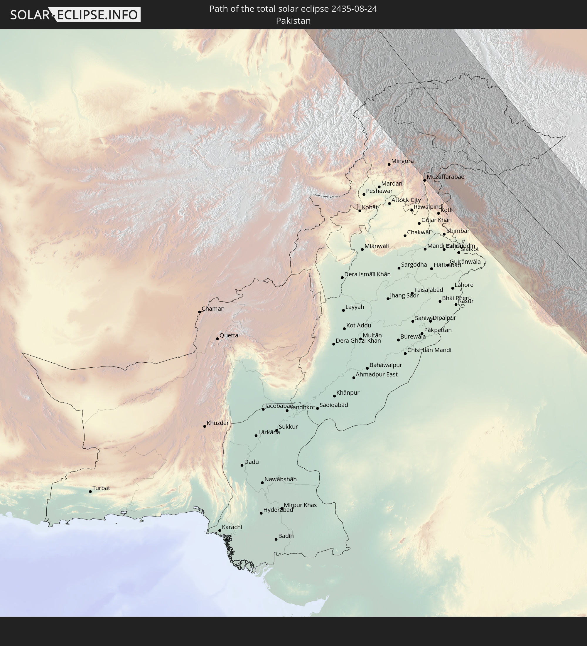 Pakistan
 Tadschikistan
 Indien
 Kirgisistan
 Volksrepublik China
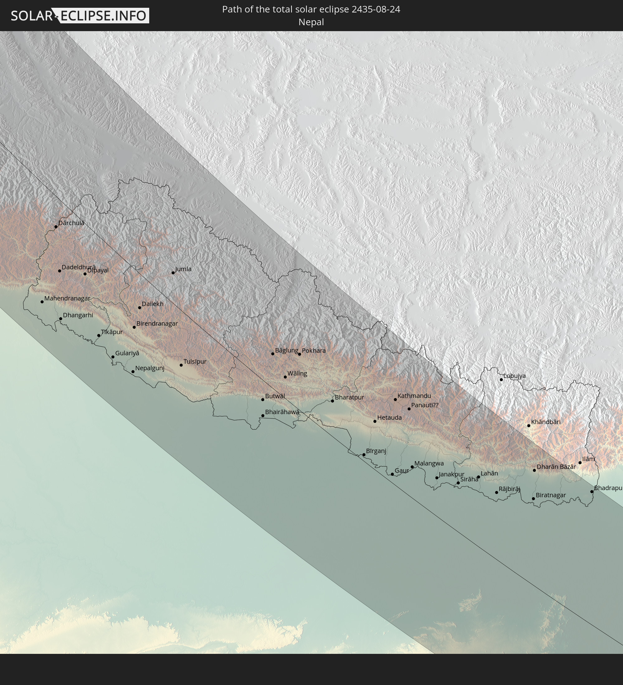 Nepal
Nepal
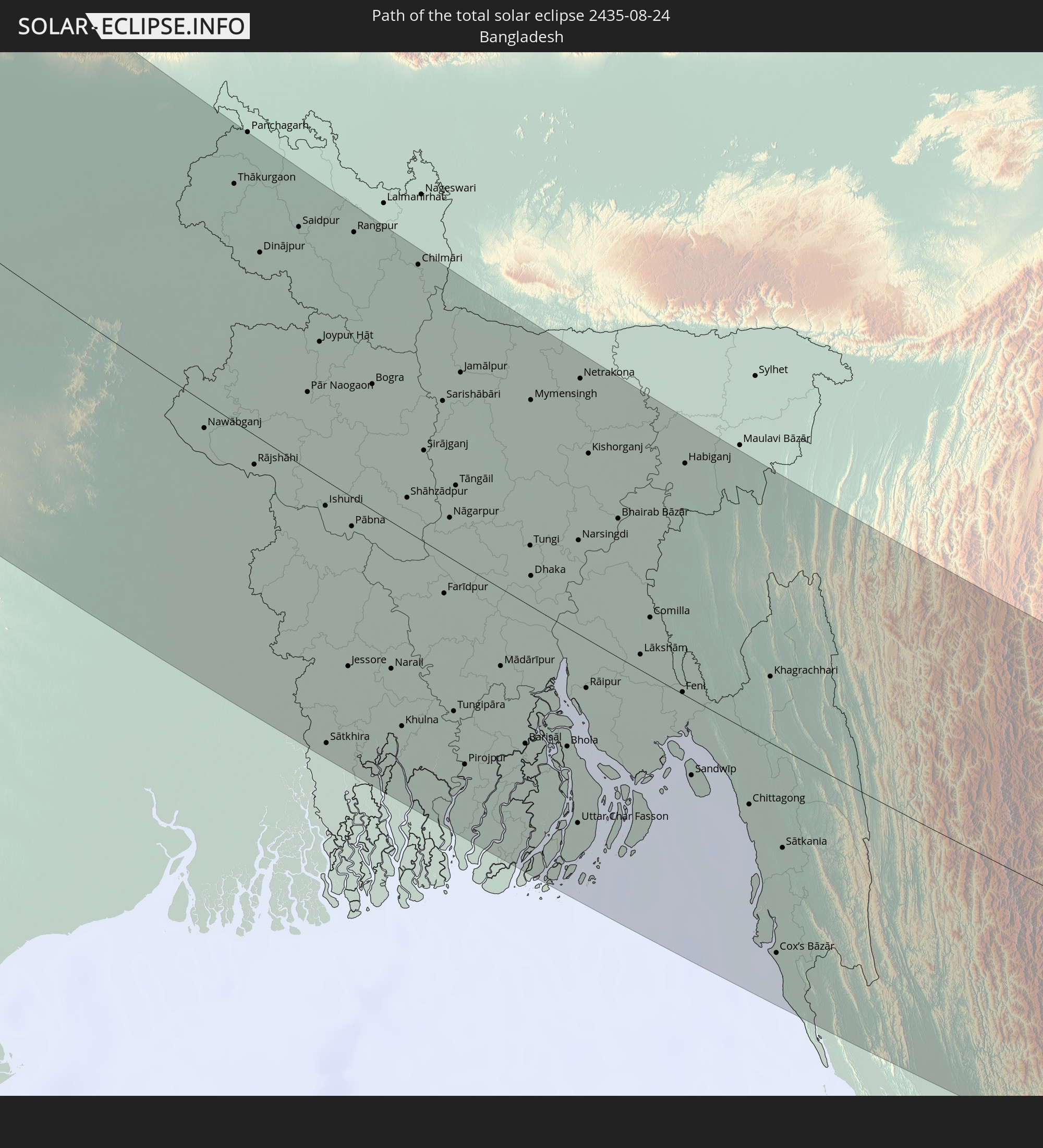 Bangladesch
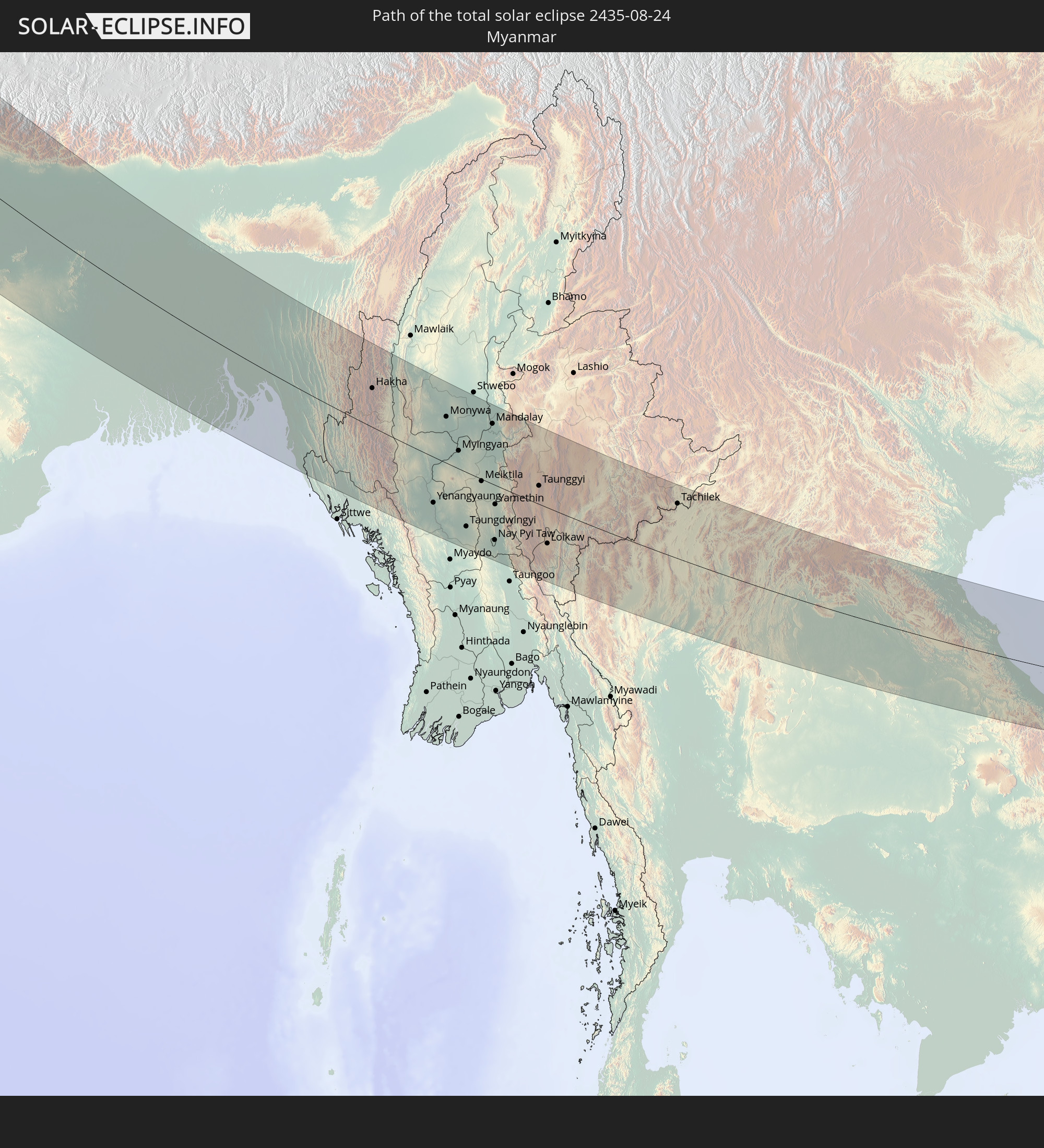 Myanmar
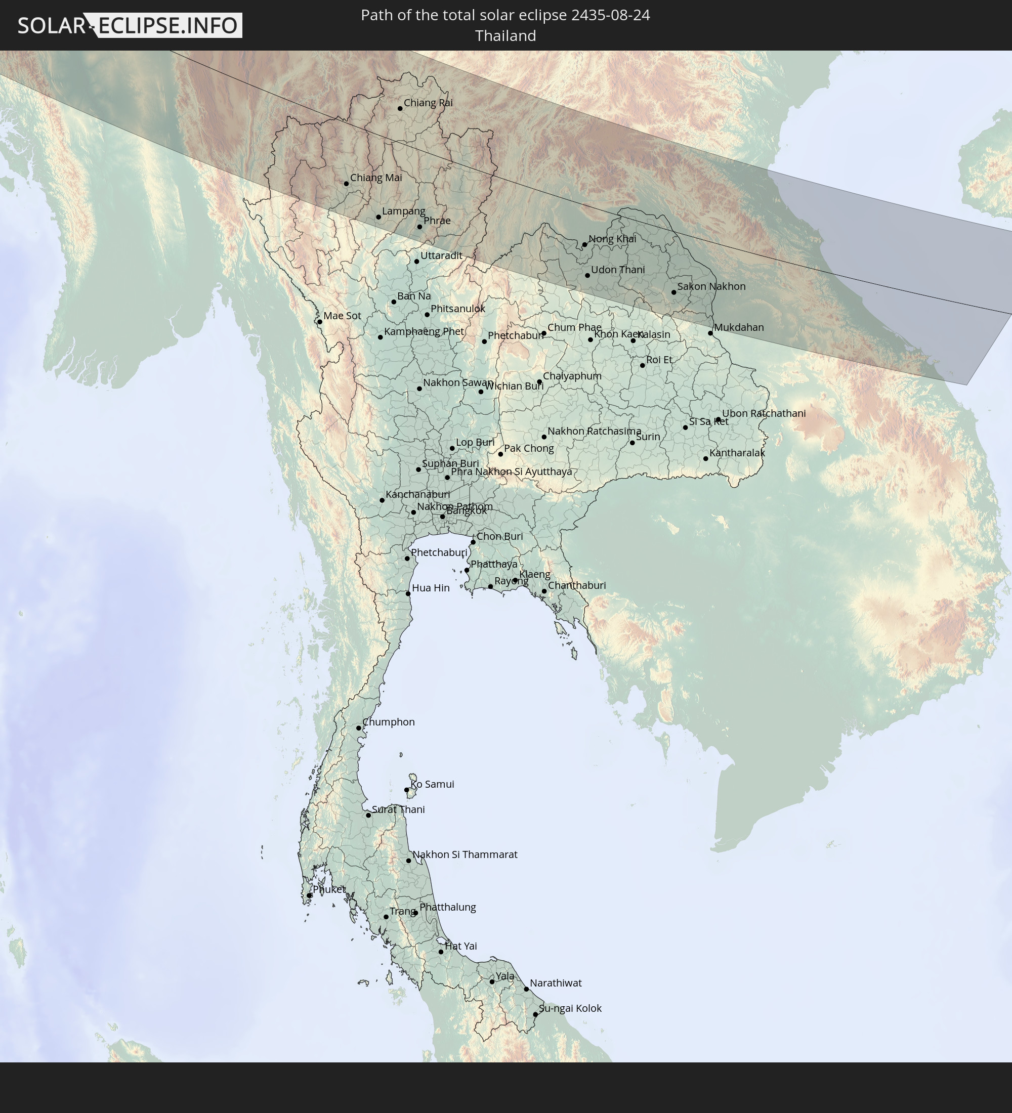 Thailand
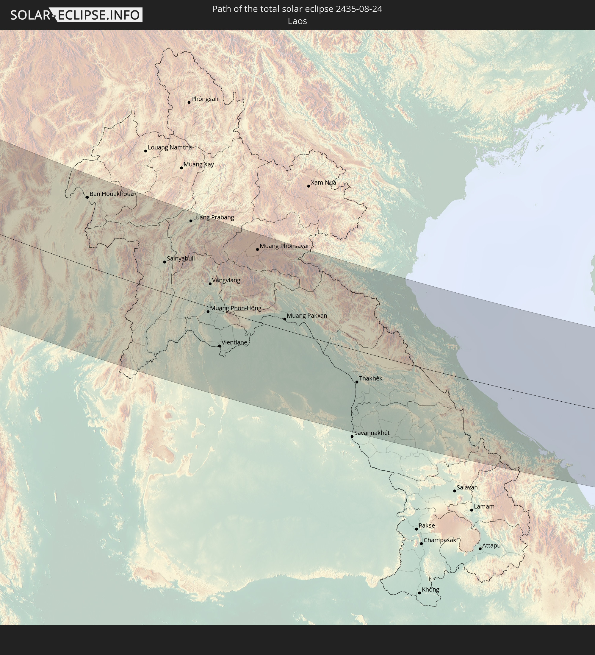 Laos
Laos
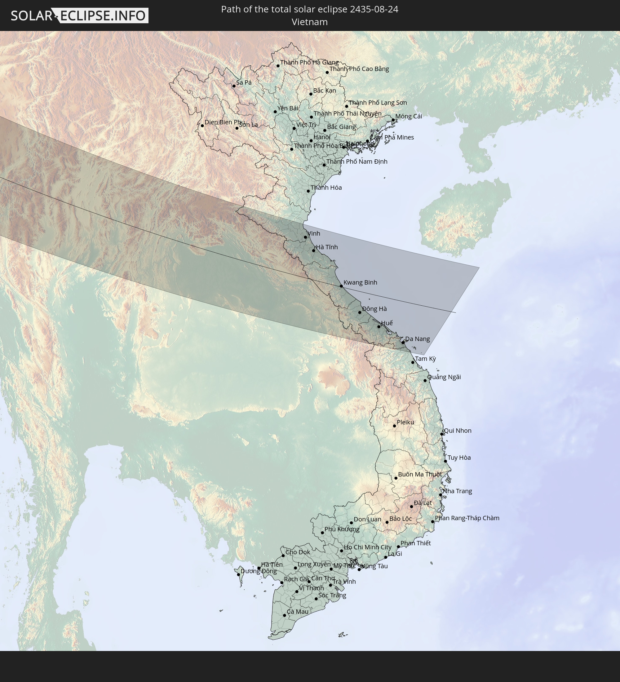 Vietnam
In den folgenden Ländern ist die Sonnenfinsternis partiell zu sehen
 Russland
 Kanada
 Grönland
 Portugal
 Island
 Spanien
 Irland
 Spitzbergen
 Algerien
 Vereinigtes Königreich
 Färöer
 Frankreich
 Isle of Man
 Guernsey
 Jersey
 Andorra
 Belgien
 Niederlande
 Norwegen
 Luxemburg
 Deutschland
 Schweiz
 Italien
 Monaco
 Tunesien
 Dänemark
 Libyen
 Liechtenstein
 Österreich
 Schweden
 Tschechien
 San Marino
 Vatikanstadt
 Slowenien
 Kroatien
 Polen
Polen
 Malta
Malta
 Bosnien und Herzegowina
 Ungarn
 Slowakei
 Montenegro
 Serbien
 Albanien
 Åland Islands
 Griechenland
 Rumänien
 Mazedonien
 Finnland
 Litauen
 Lettland
 Estland
 Sudan
Sudan
 Ukraine
 Bulgarien
 Weißrussland
 Ägypten
 Türkei
 Moldawien
 Republik Zypern
 Staat Palästina
 Israel
 Saudi-Arabien
 Jordanien
 Libanon
 Syrien
 Eritrea
 Irak
Irak
 Georgien
 Somalia
 Jemen
Jemen
 Armenien
 Iran
Iran
 Aserbaidschan
 Kasachstan
 Kuwait
 Bahrain
 Katar
Katar
 Vereinigte Arabische Emirate
 Oman
Oman
 Turkmenistan
 Usbekistan
 Afghanistan
 Pakistan
 Tadschikistan
 Indien
 Kirgisistan
 Britisches Territorium im Indischen Ozean
 Malediven
 Volksrepublik China
 Sri Lanka
 Nepal
Nepal
 Mongolei
 Bangladesch
 Bhutan
 Myanmar
 Indonesien
 Thailand
 Malaysia
 Laos
Laos
 Vietnam
 Kambodscha
 Nordkorea
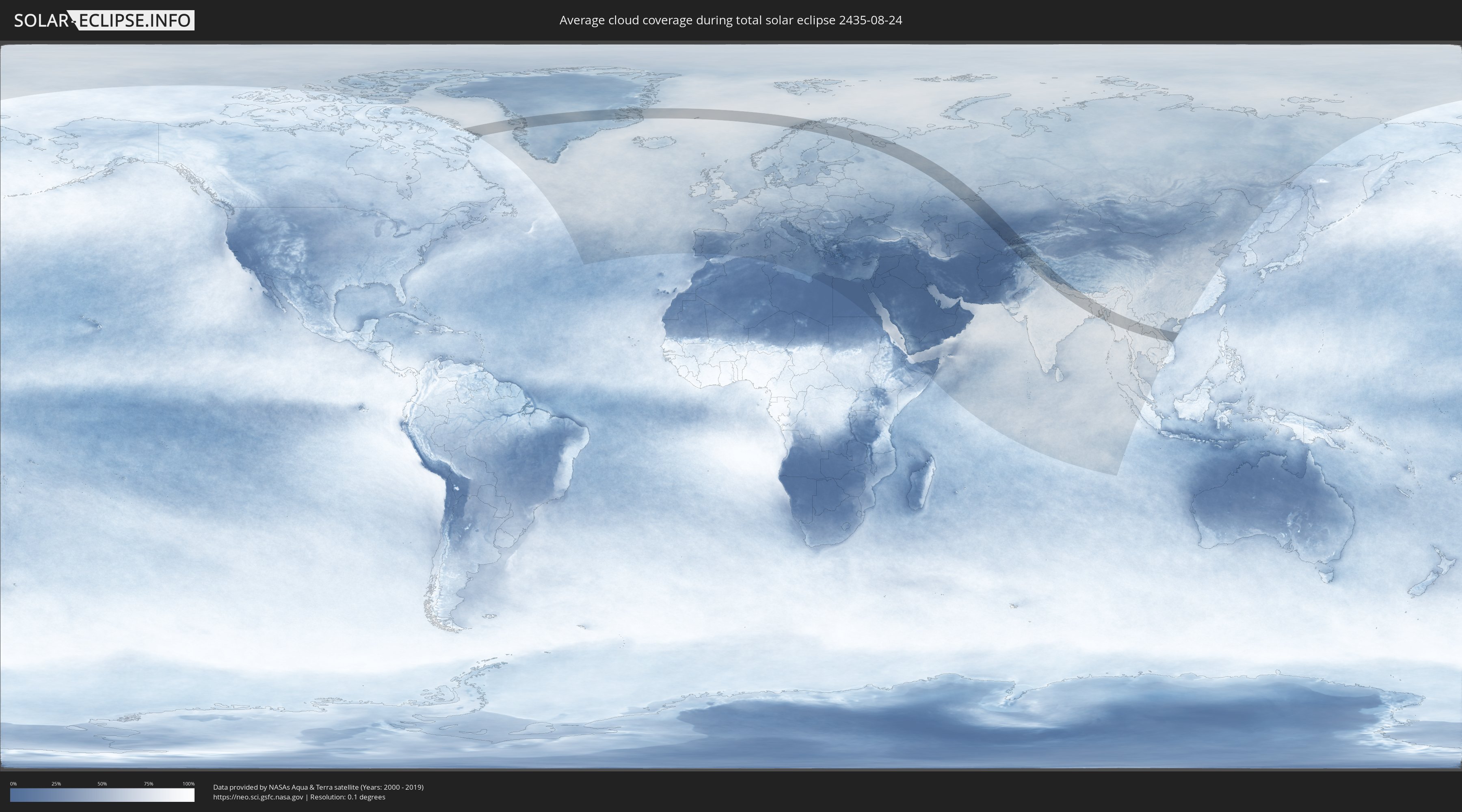
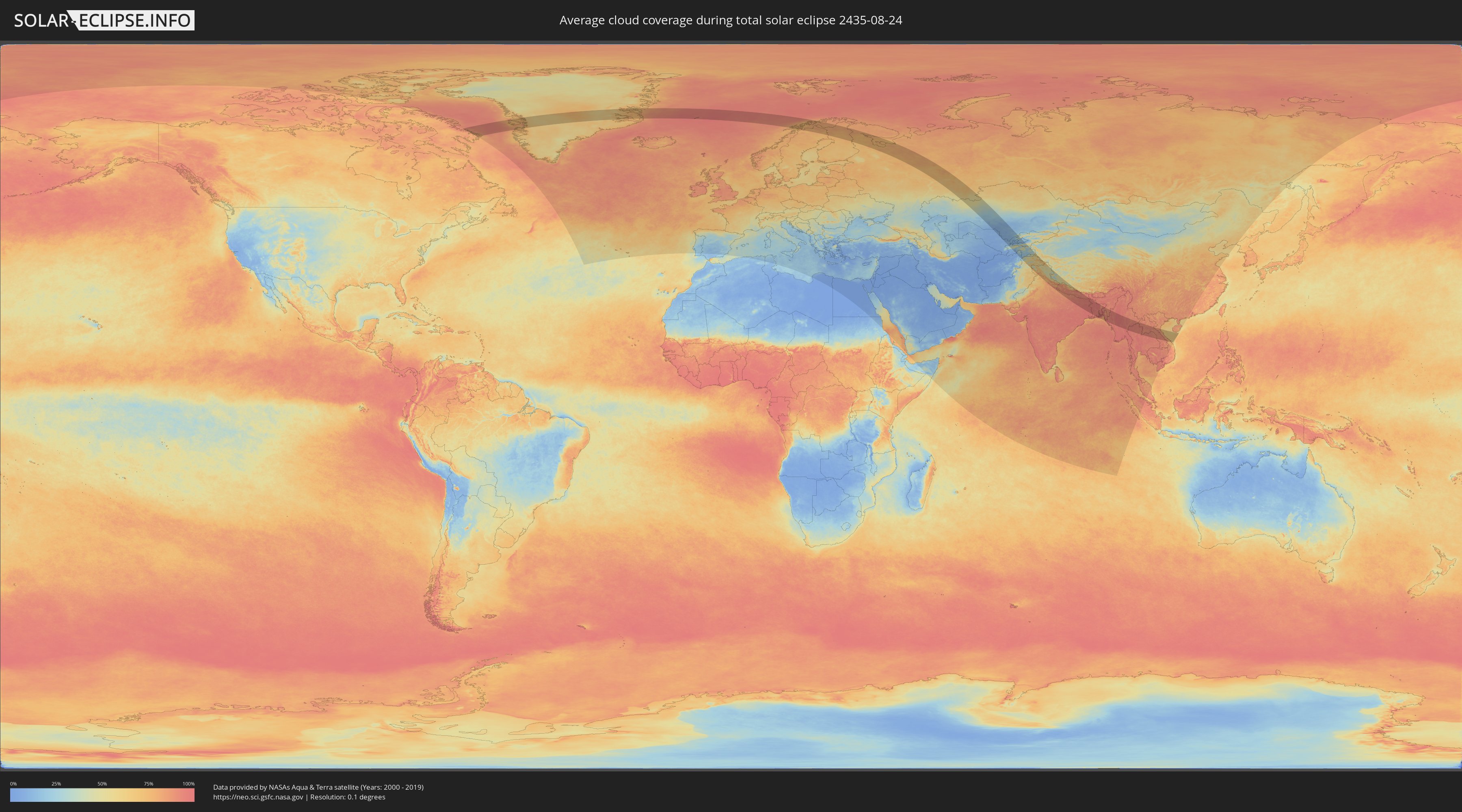
Wie wird das Wetter während der totalen Sonnenfinsternis am 24.08.2435?
Wo ist der beste Ort, um die totale Sonnenfinsternis vom 24.08.2435 zu beobachten?
Die folgenden Karten zeigen die durchschnittliche Bewölkung für den Tag, an dem die totale Sonnenfinsternis
stattfindet. Mit Hilfe der Karten lässt sich der Ort entlang des Finsternispfades eingrenzen,
der die besten Aussichen auf einen klaren wolkenfreien Himmel bietet.
Trotzdem muss man immer lokale Gegenenheiten beachten und sollte sich genau über das Wetter an seinem
gewählten Beobachtungsort informieren.
Die Daten stammen von den beiden NASA-Satelliten
AQUA und TERRA
und wurden über einen Zeitraum von 19 Jahren (2000 - 2019) gemittelt.
Detaillierte Länderkarten
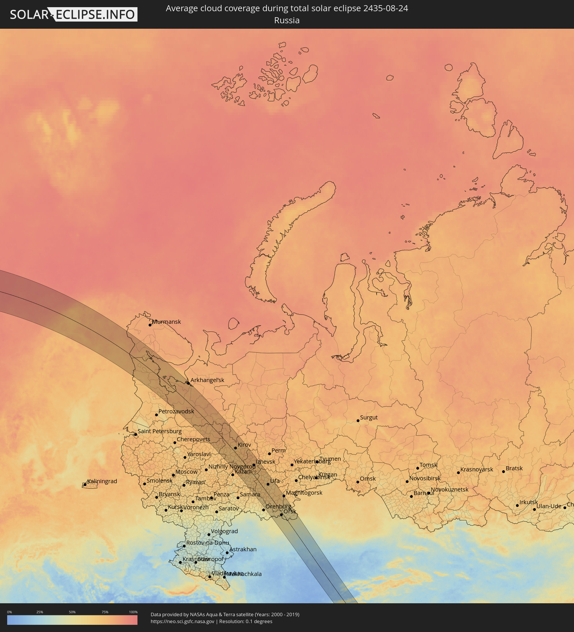 Russland
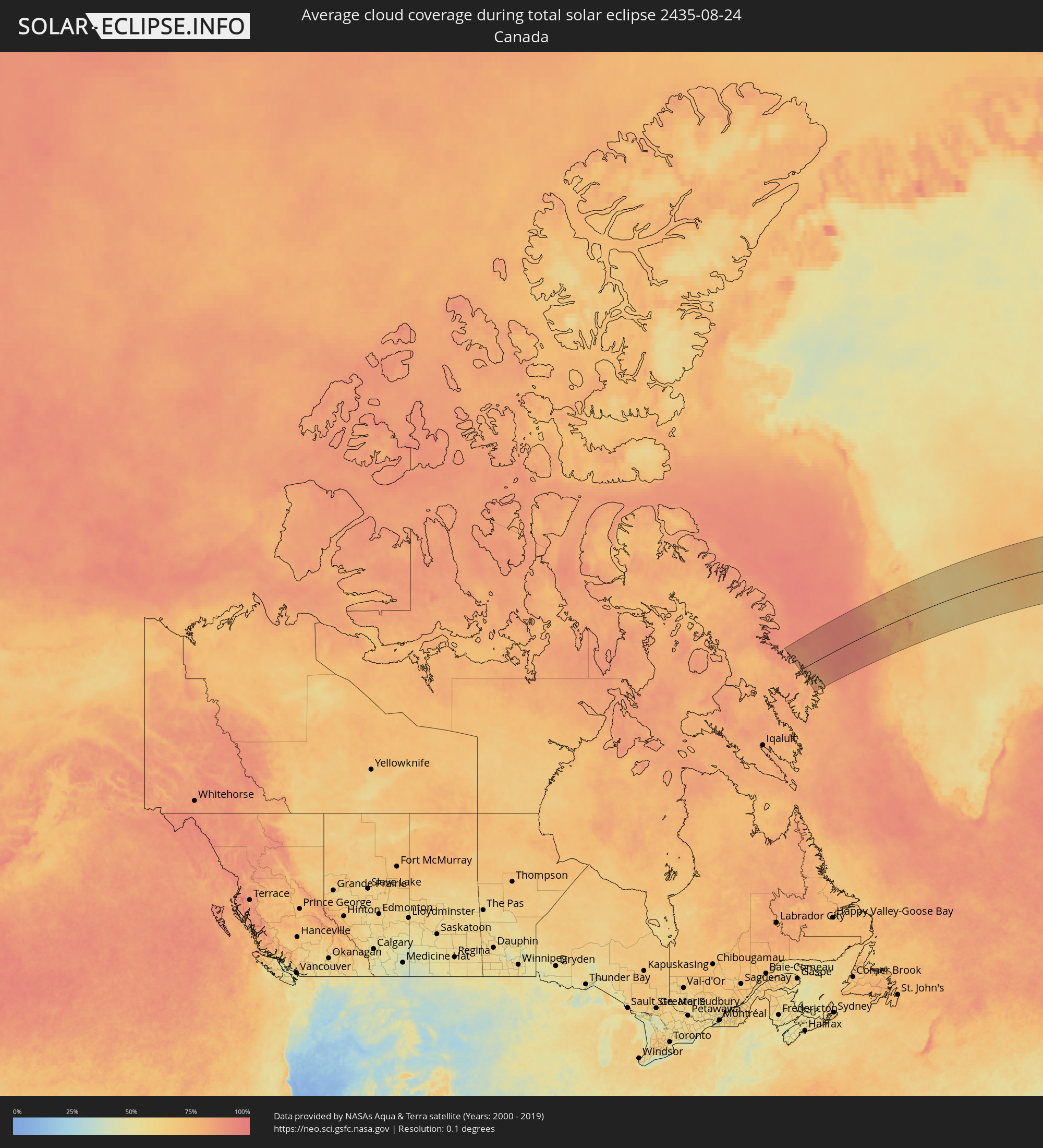 Kanada
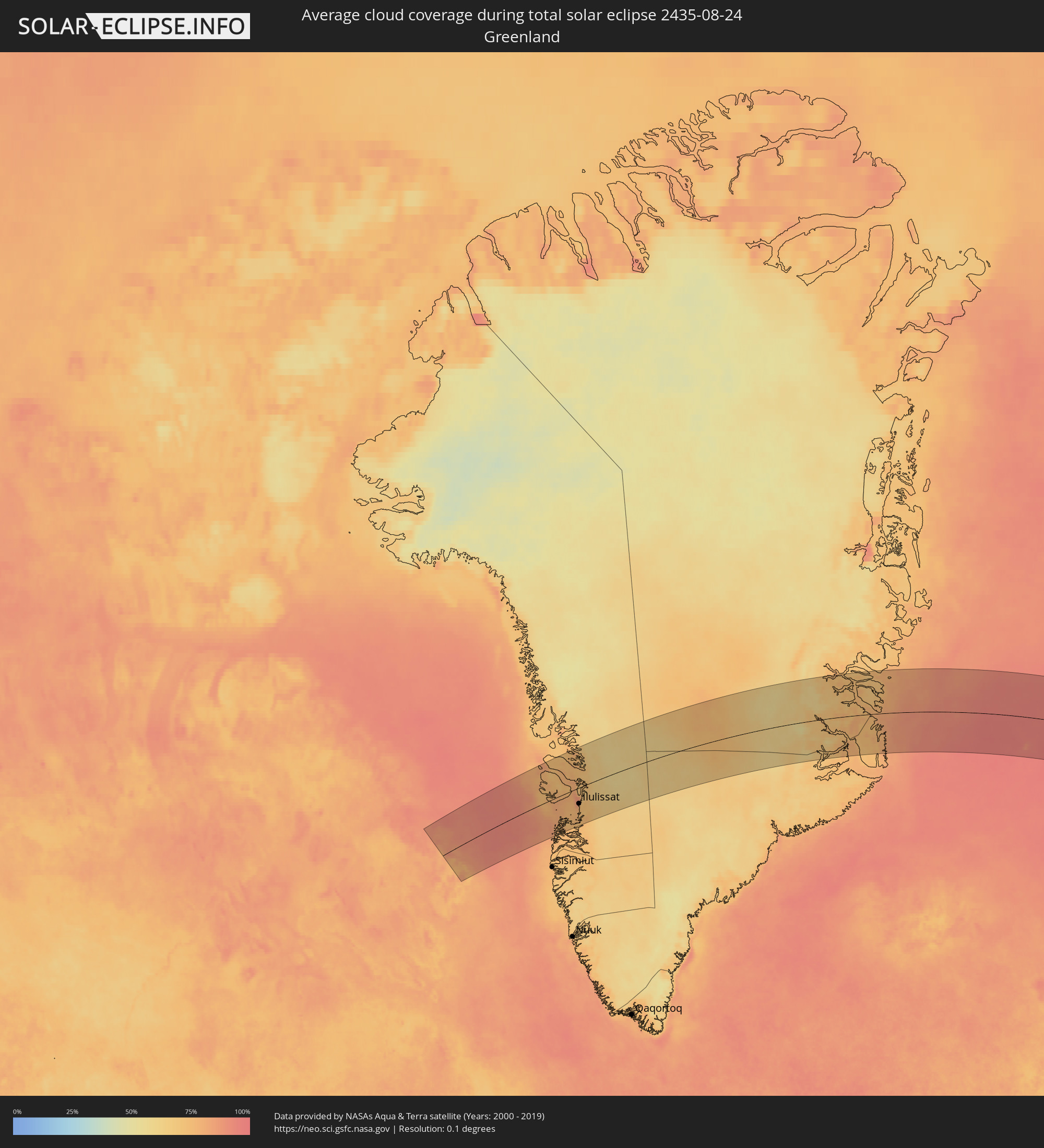 Grönland
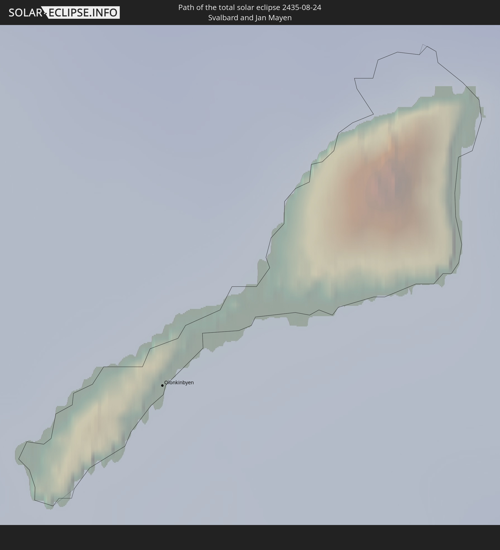
 Spitzbergen
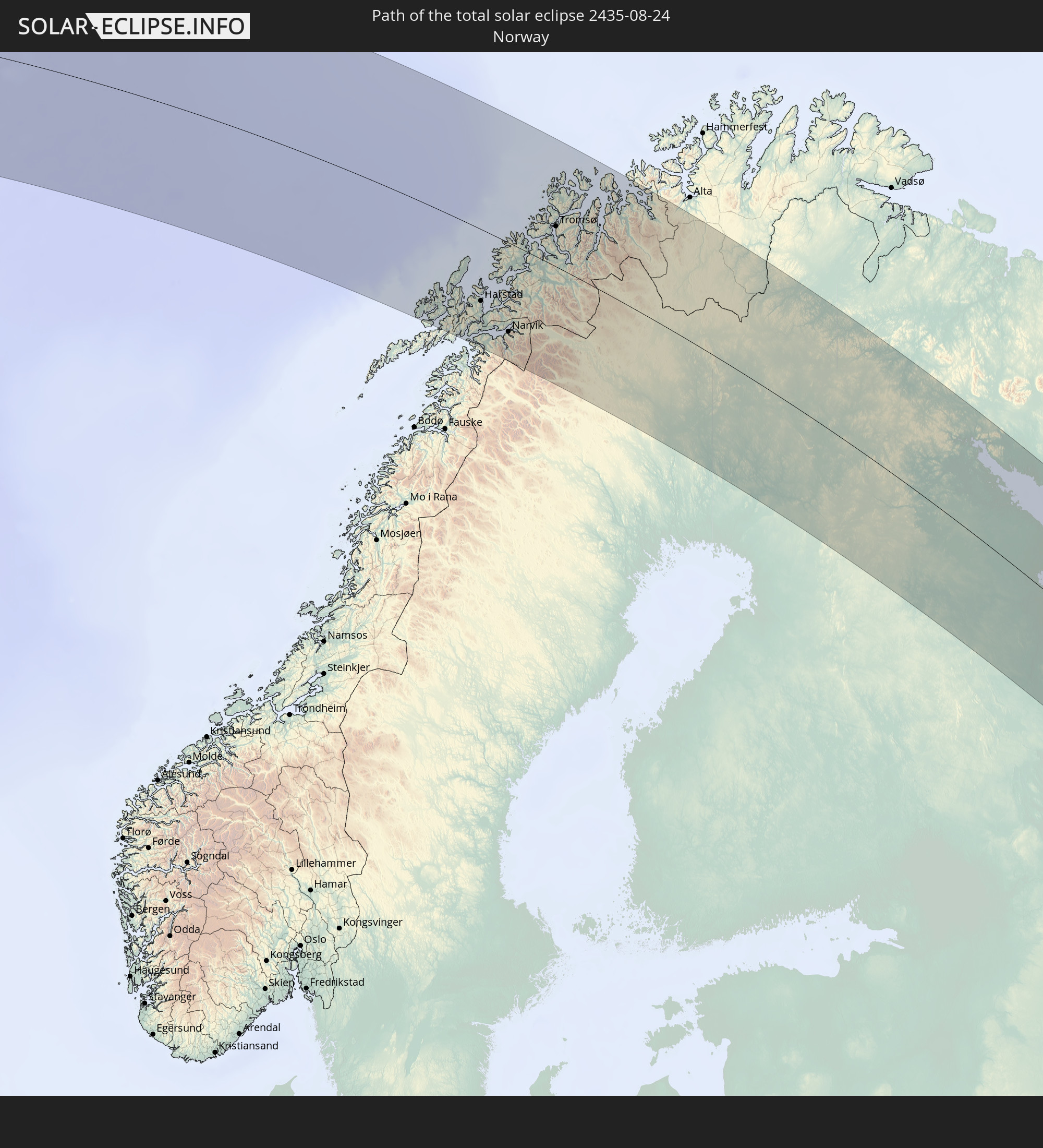
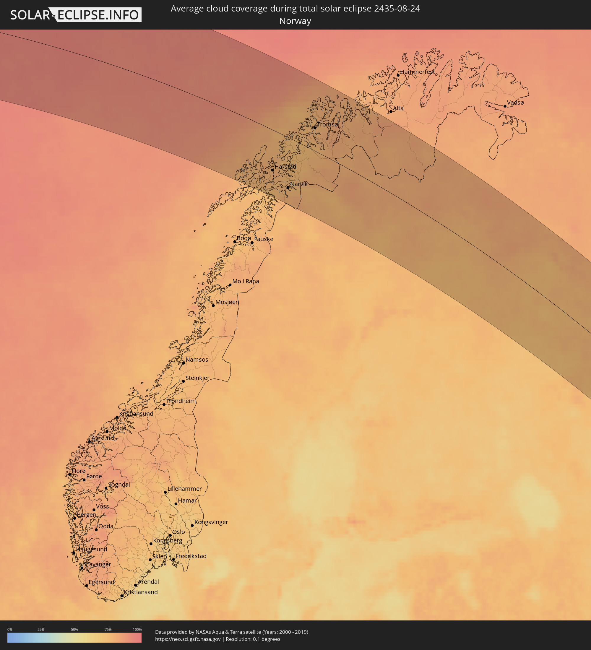 Norwegen
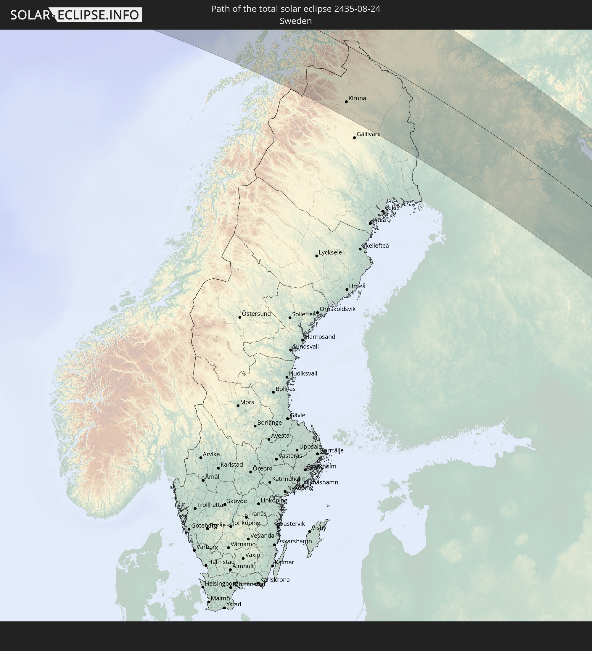
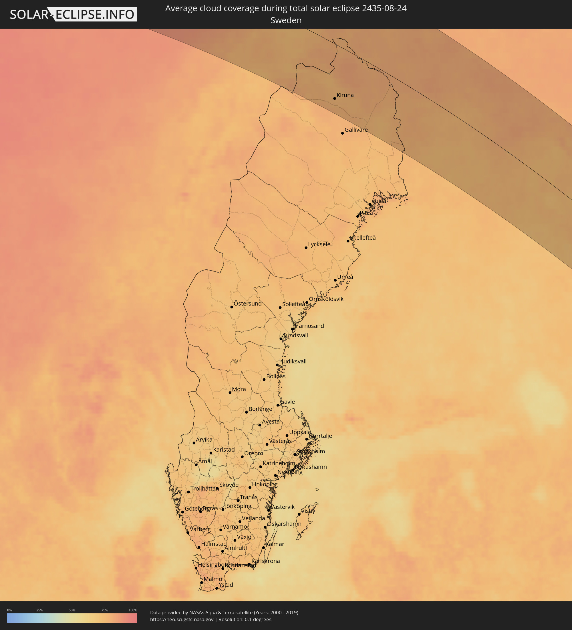 Schweden
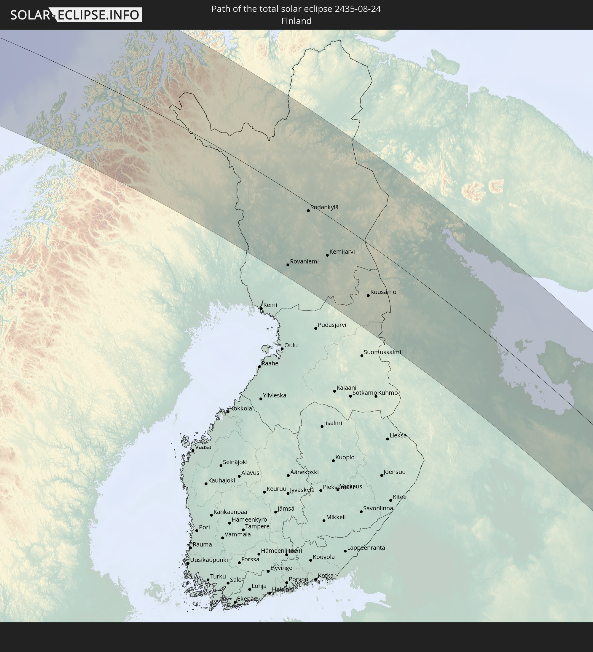
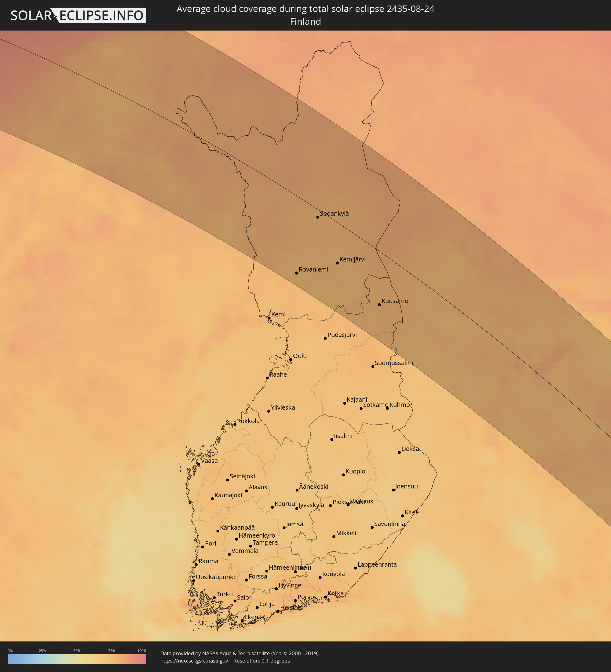 Finnland
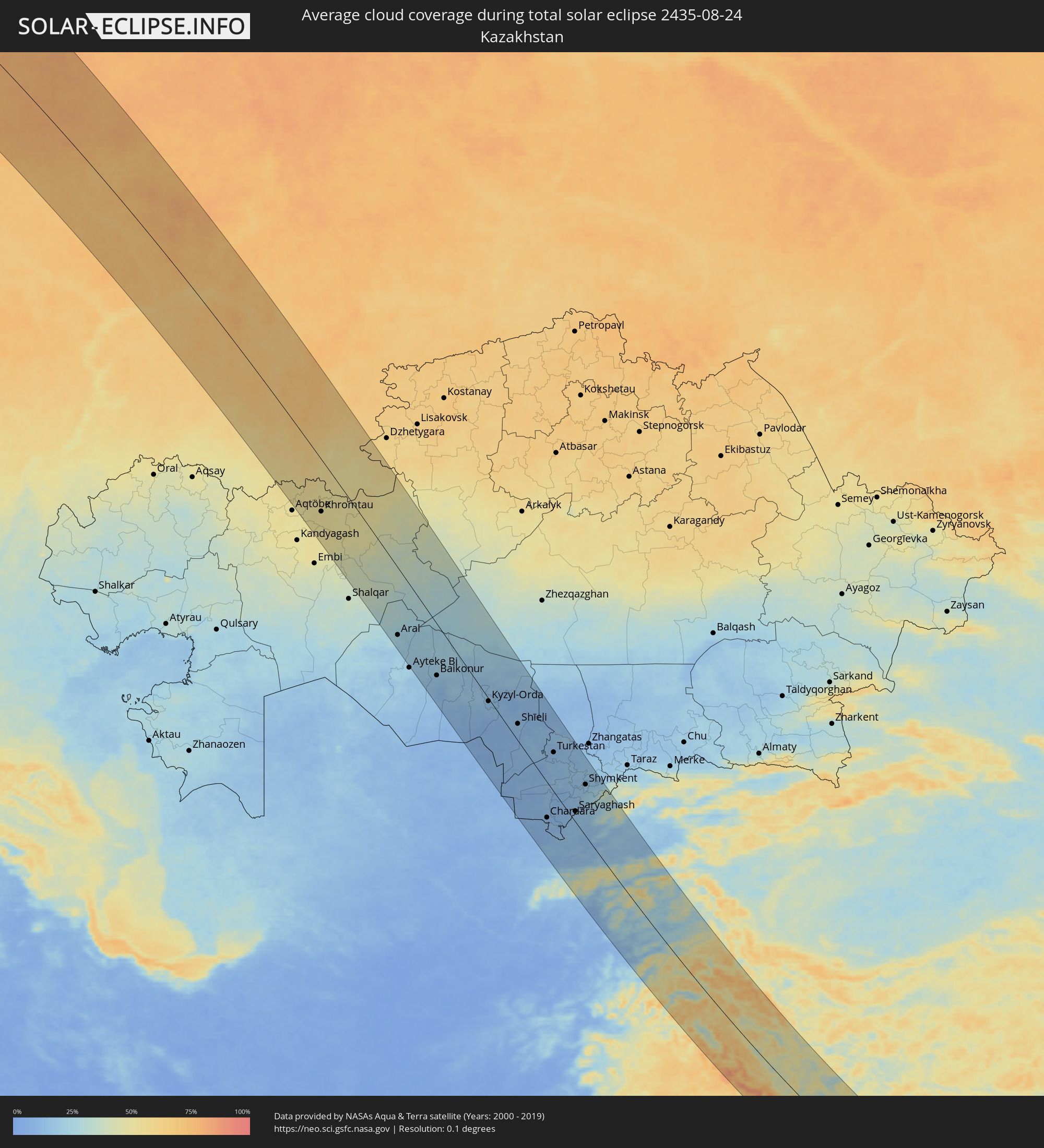 Kasachstan
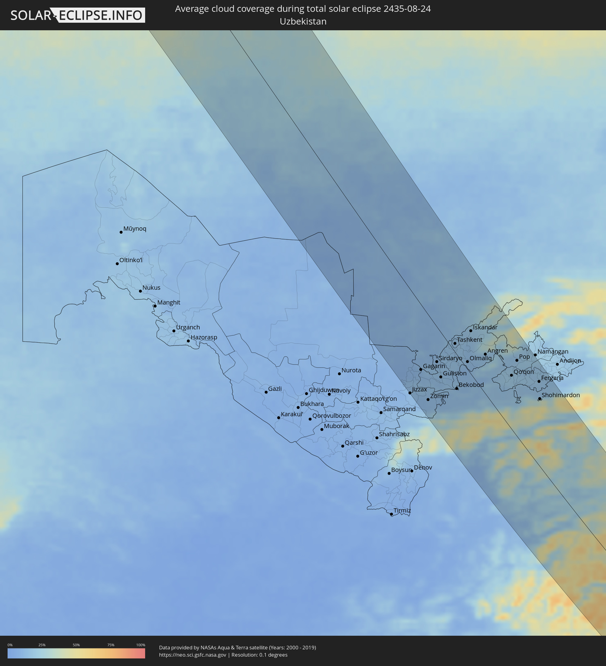 Usbekistan
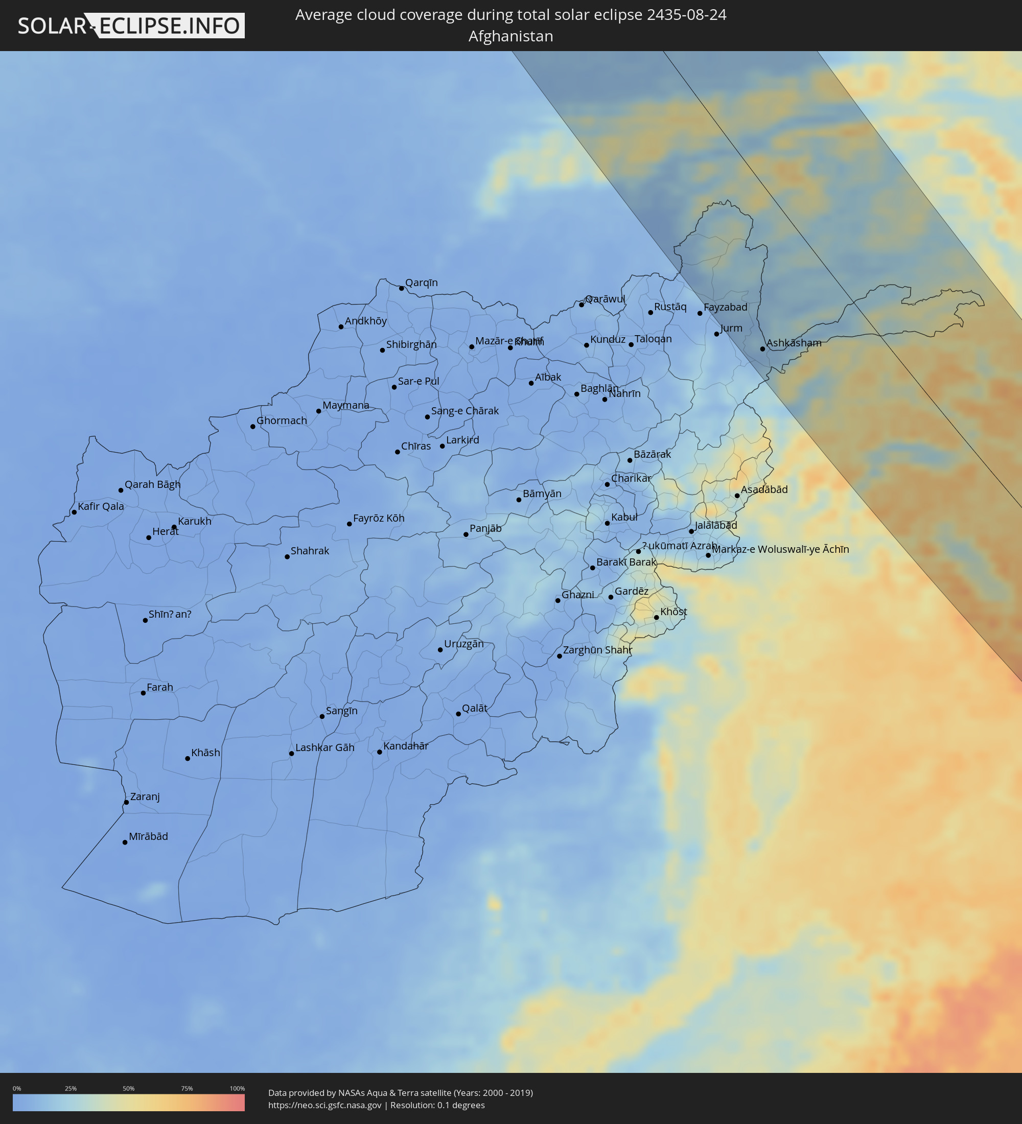 Afghanistan
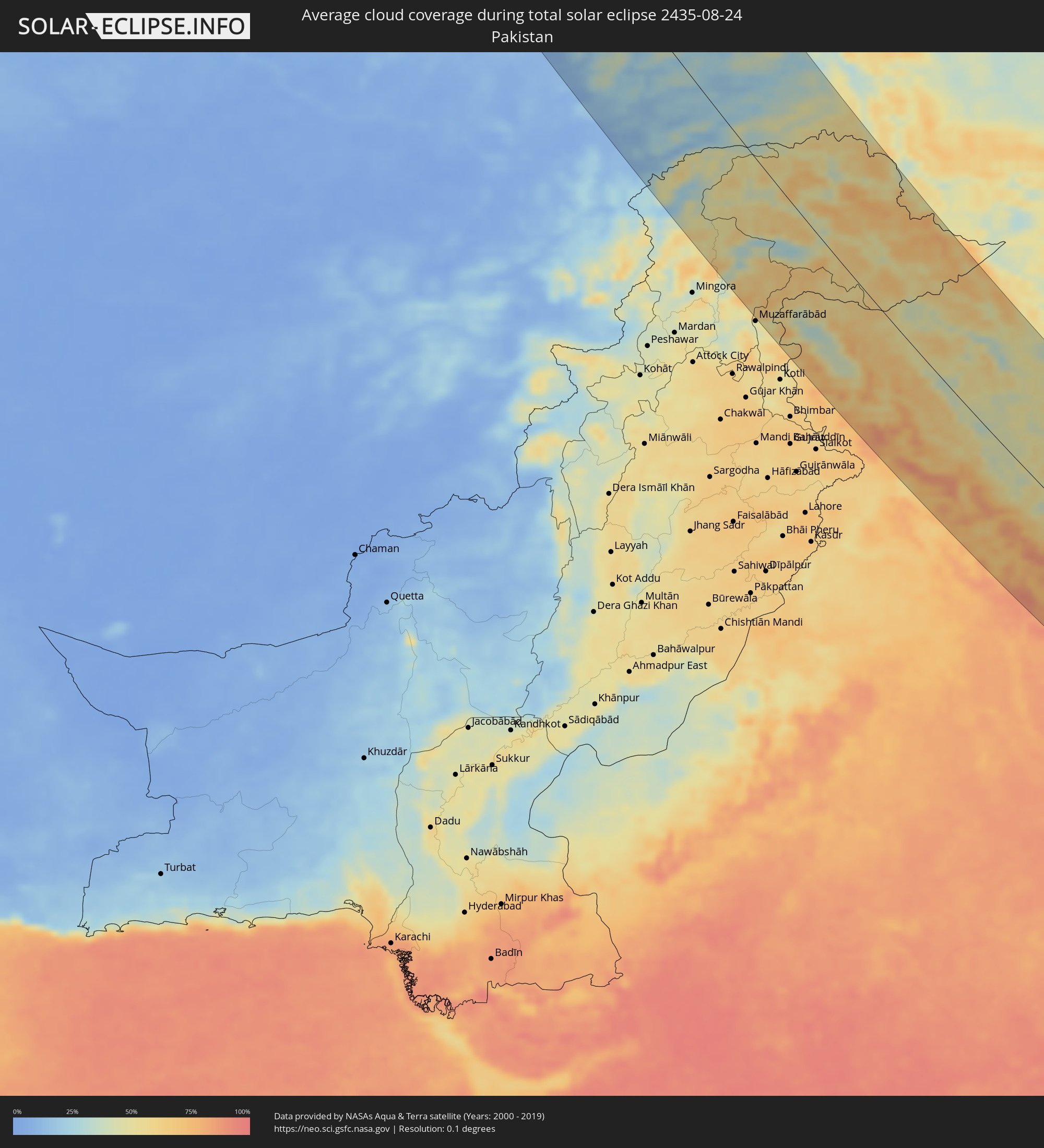 Pakistan
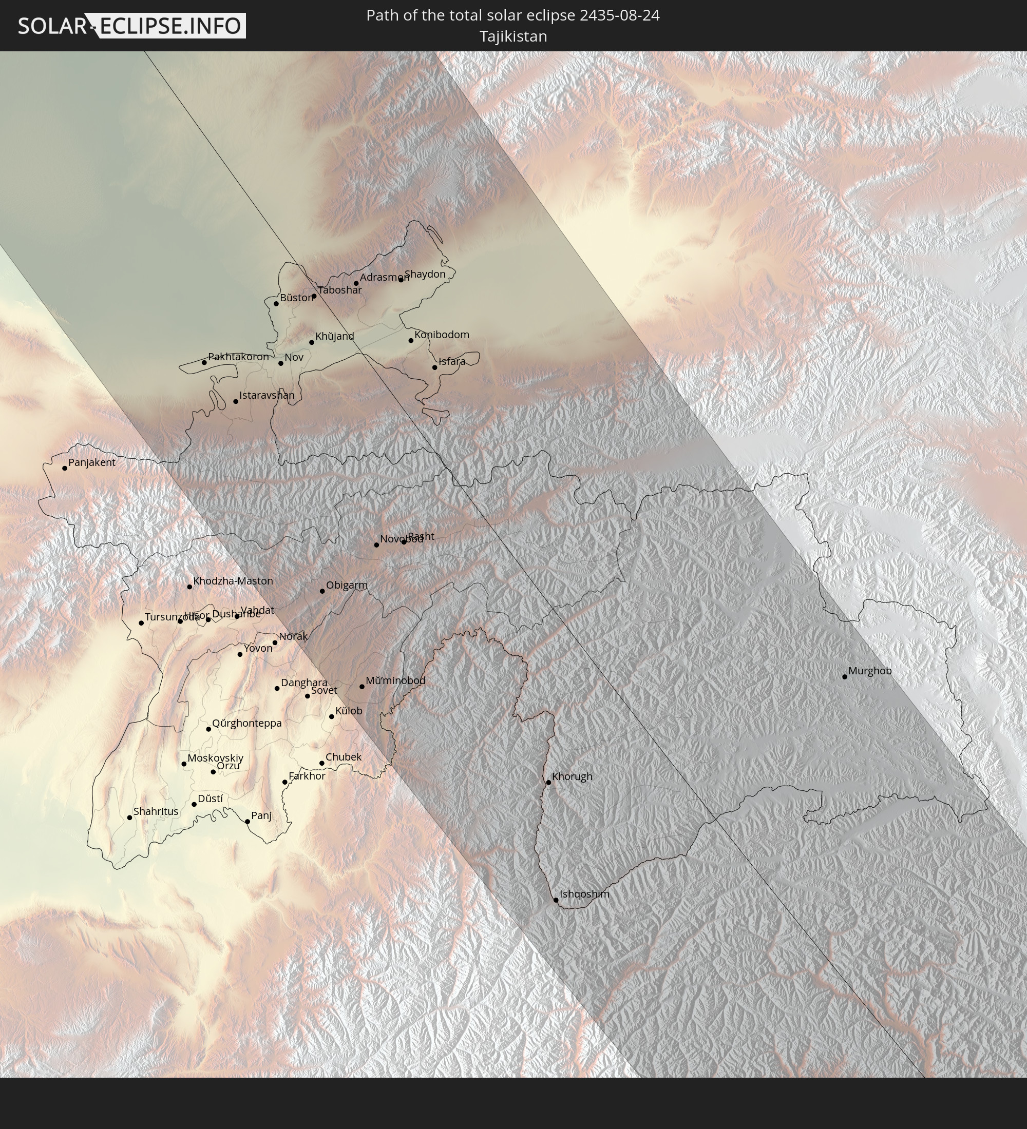
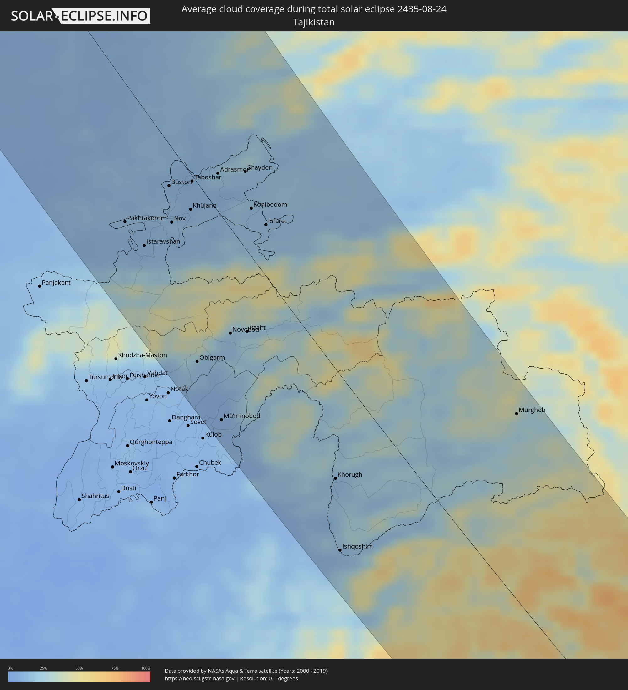 Tadschikistan
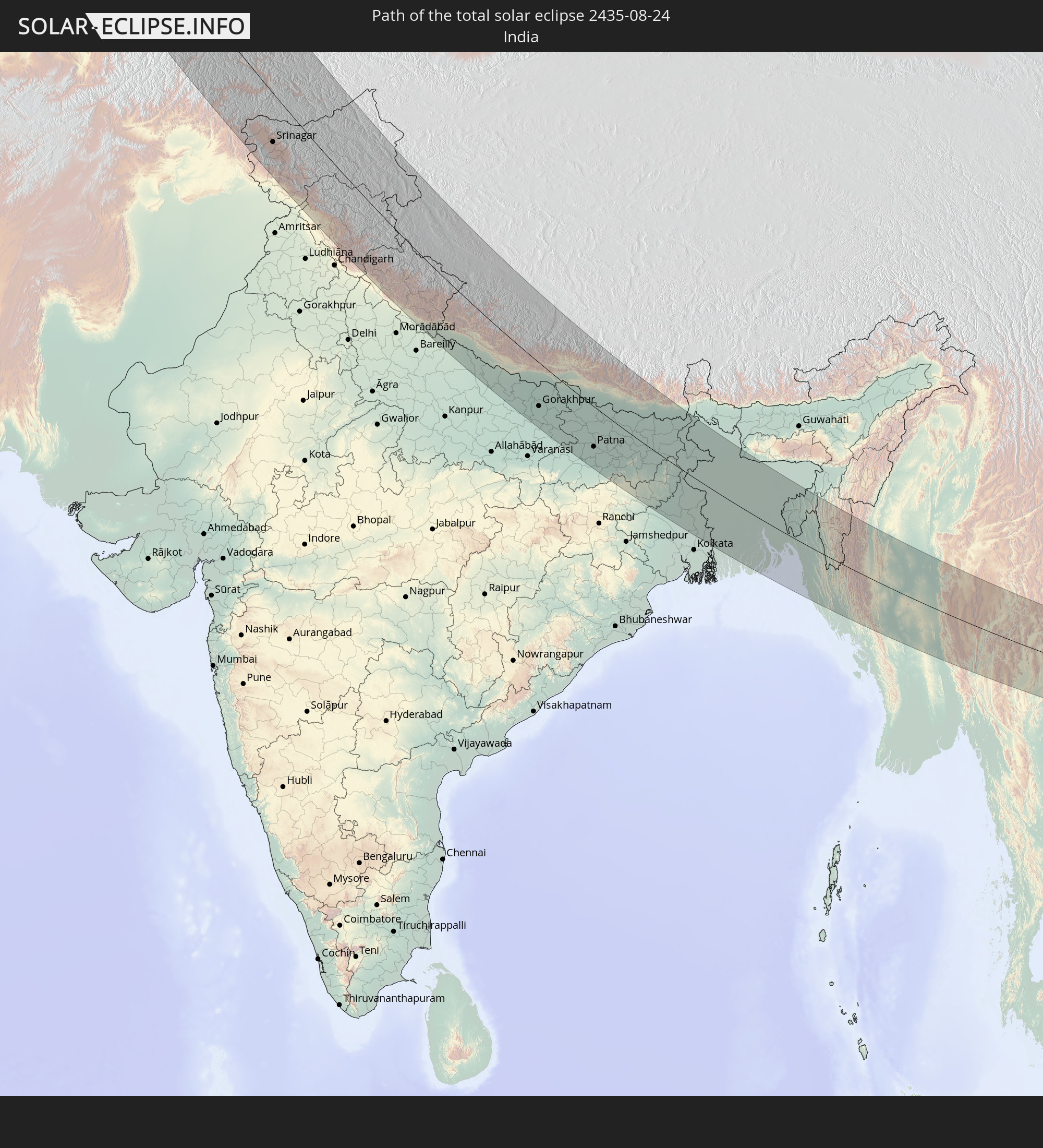
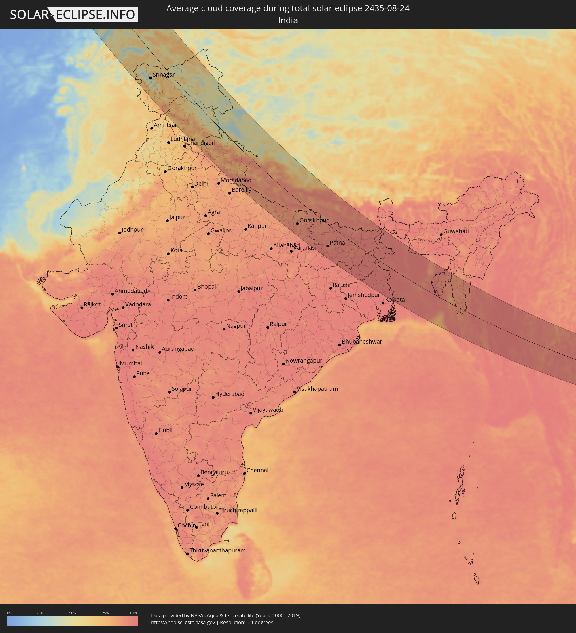 Indien
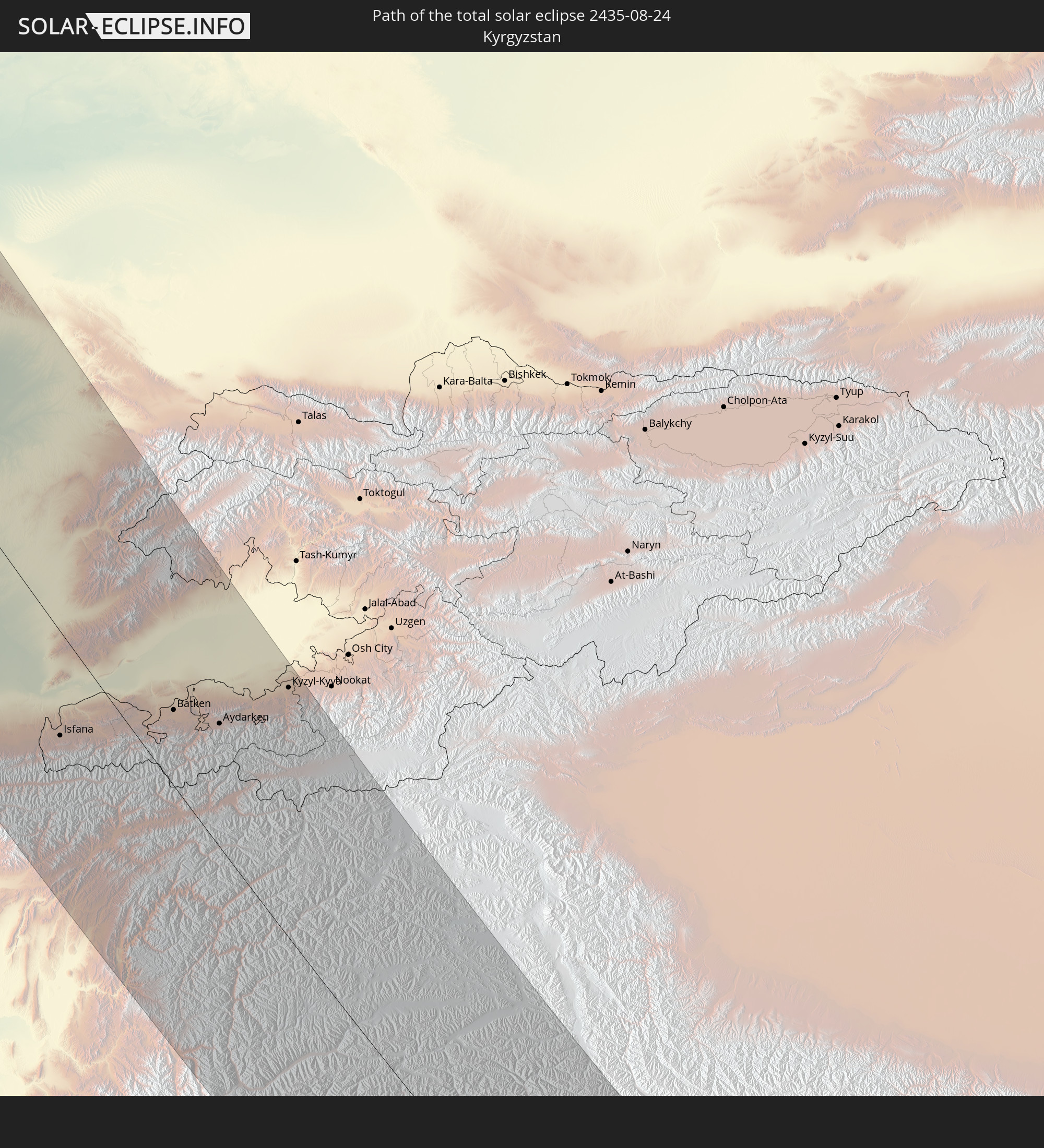
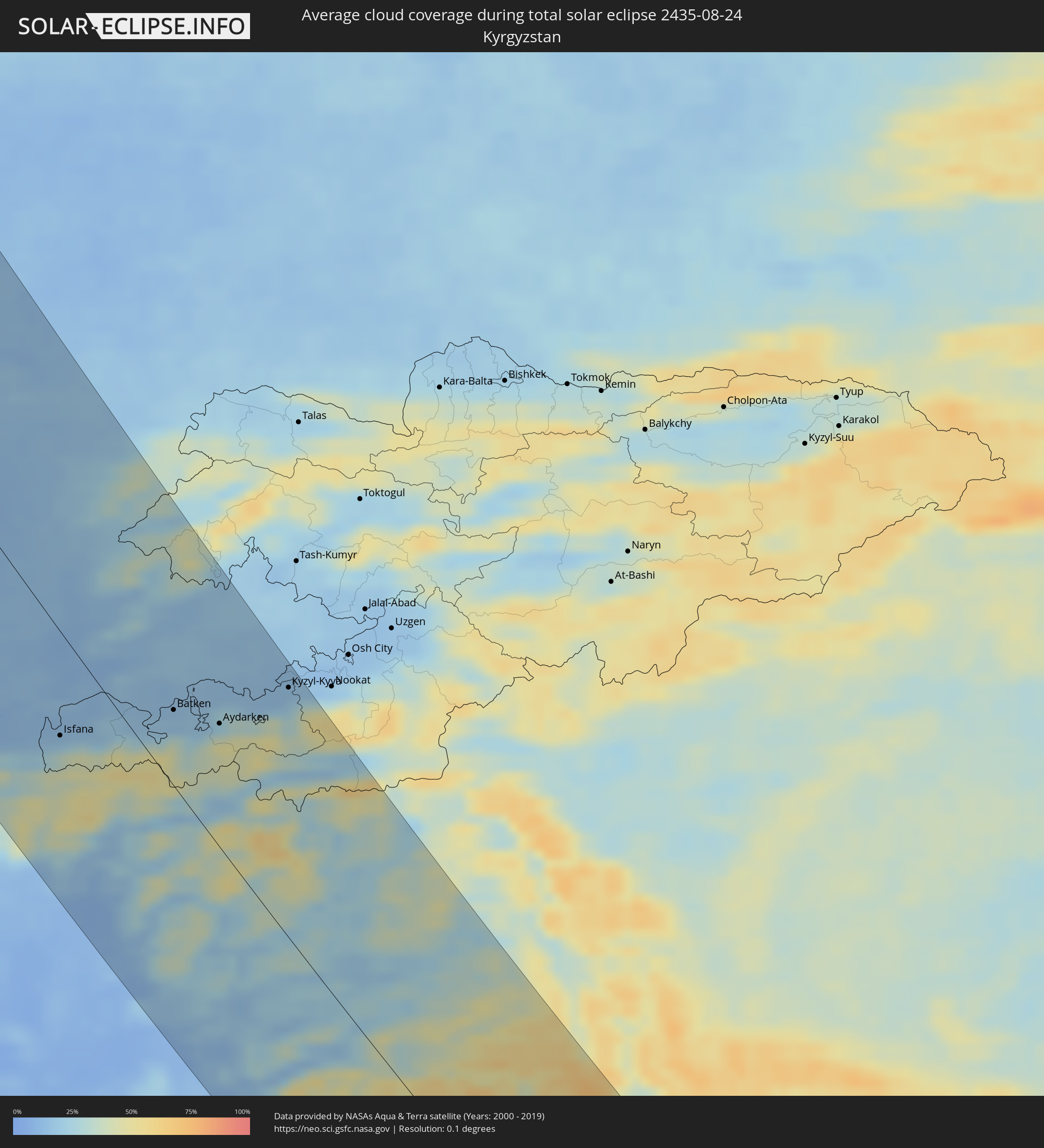 Kirgisistan
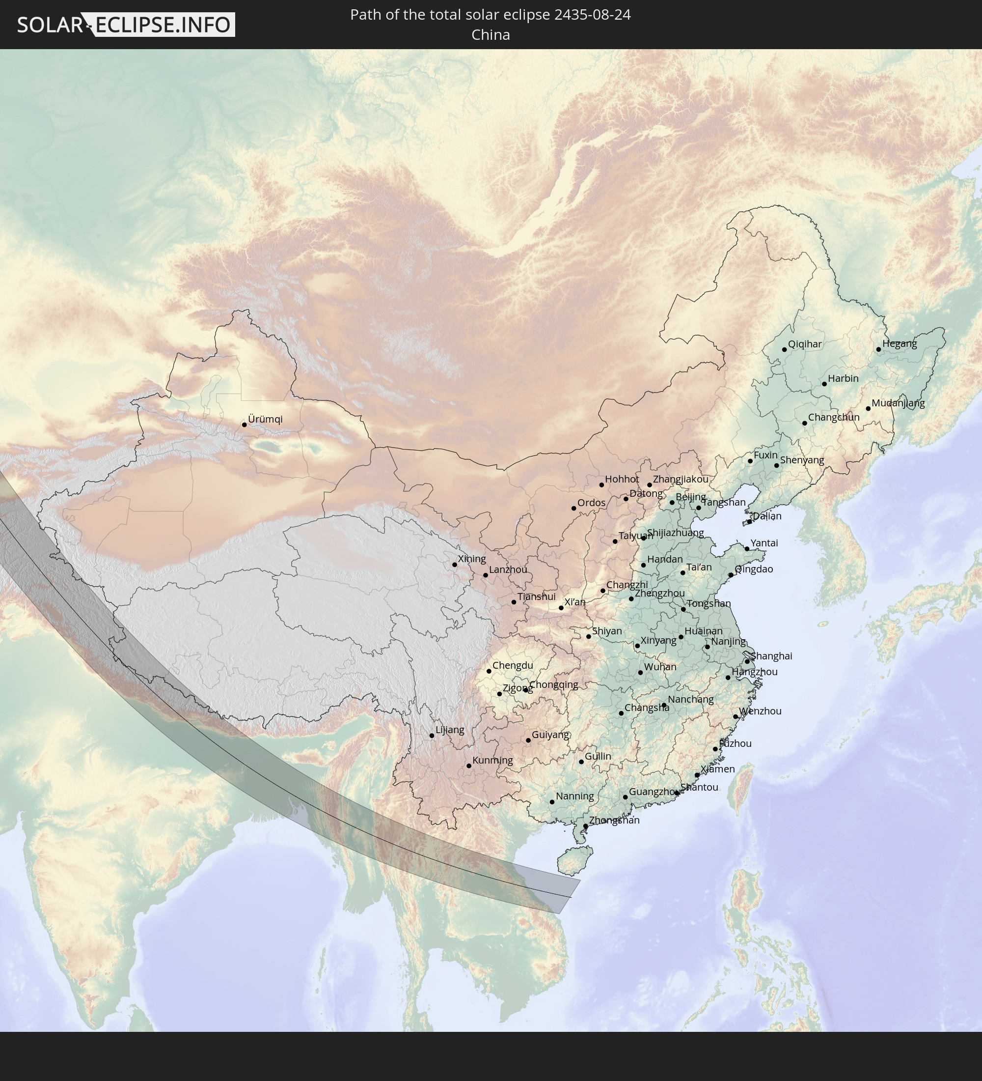
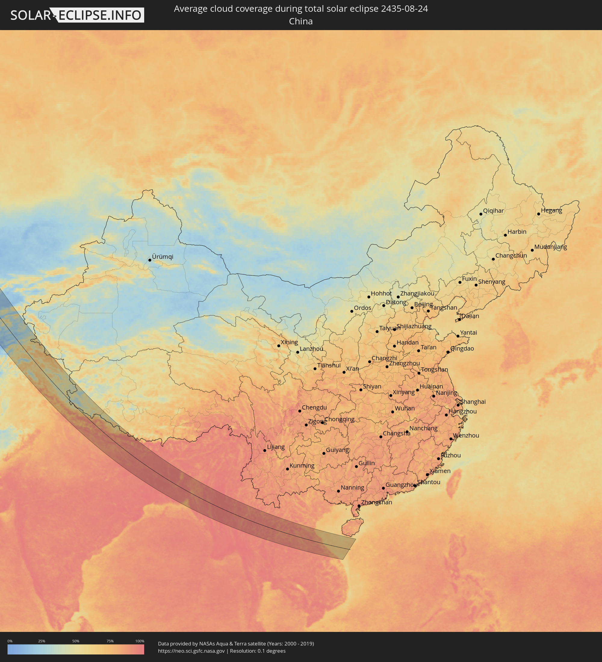 Volksrepublik China
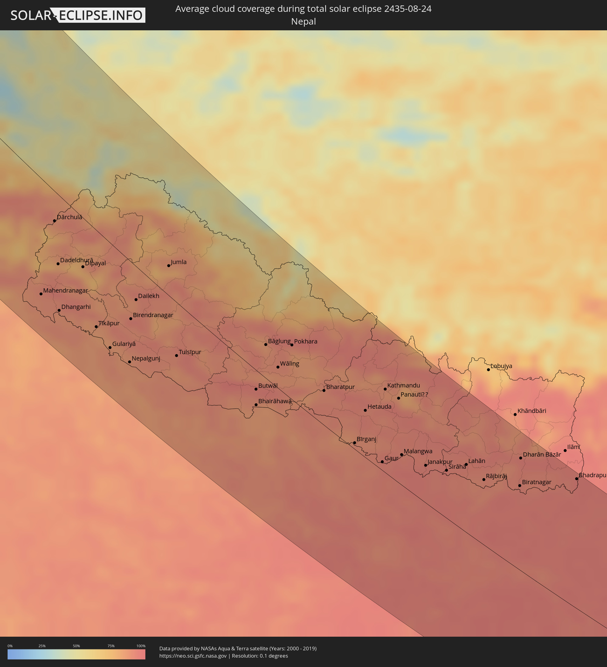 Nepal
Nepal
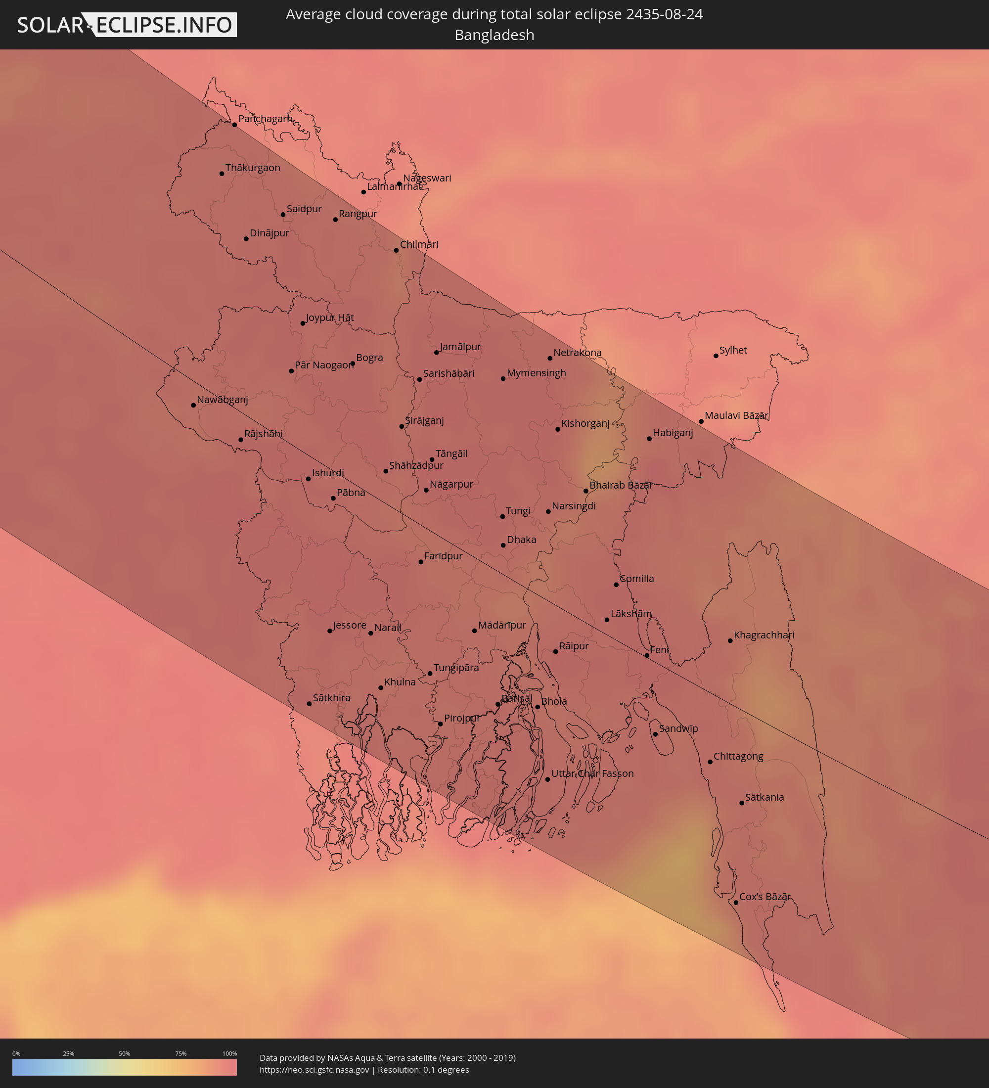 Bangladesch
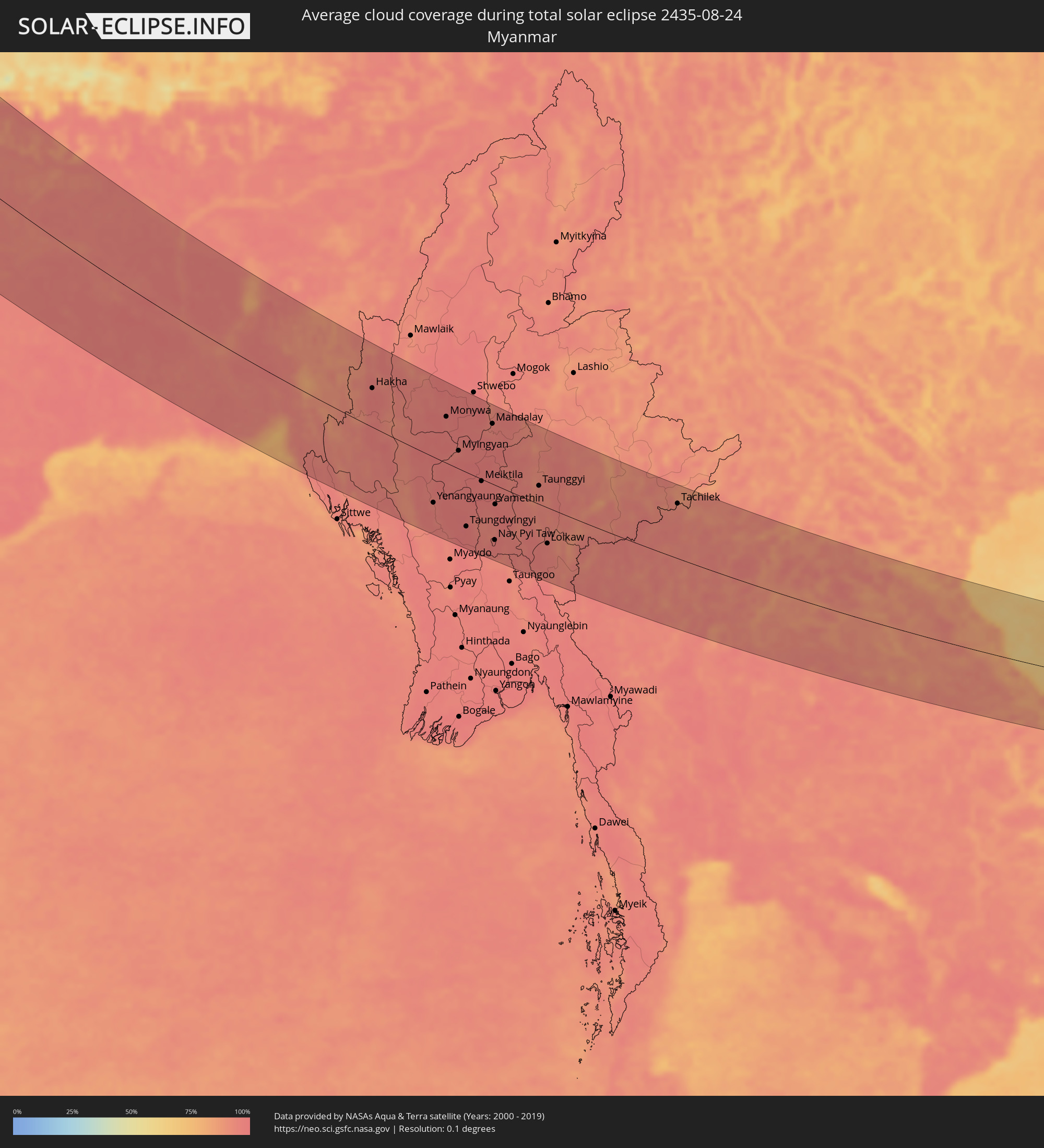 Myanmar
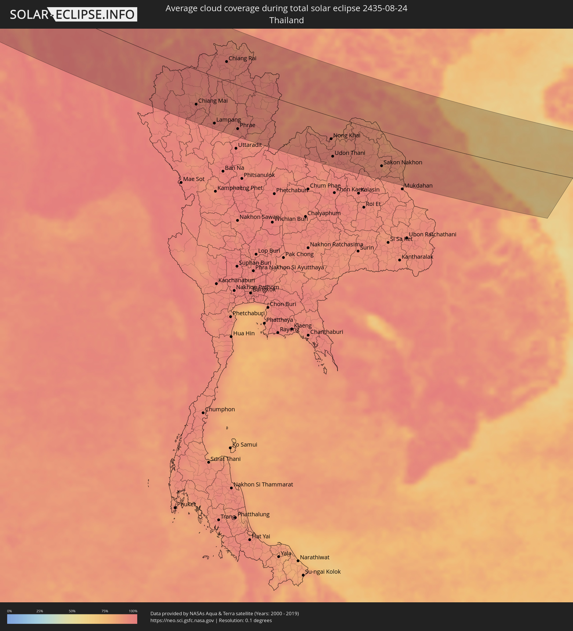 Thailand
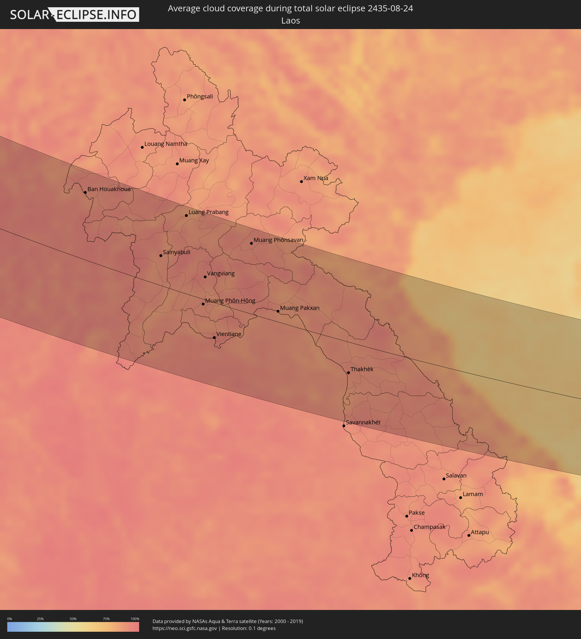 Laos
Laos
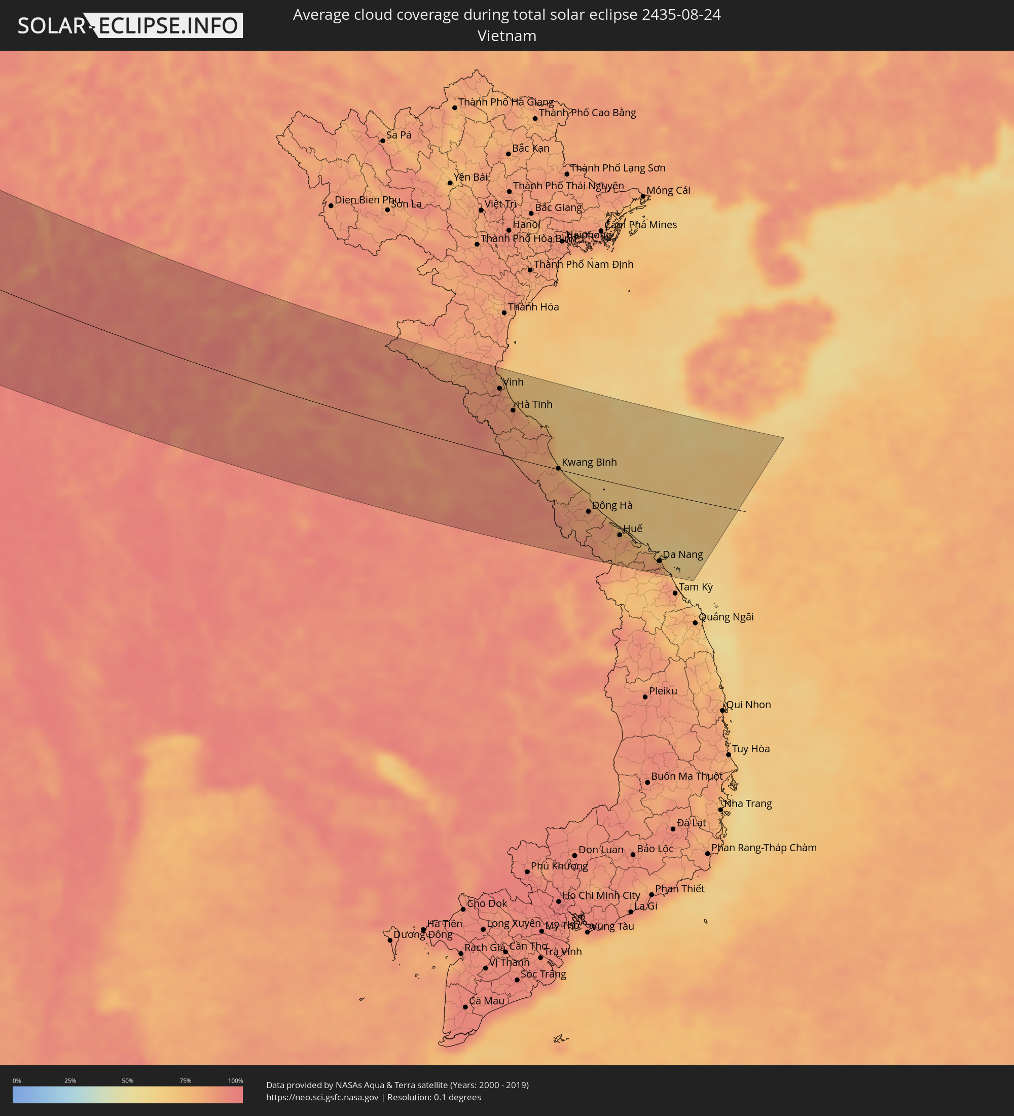 Vietnam
Orte im Finsternispfad
Die nachfolgene Tabelle zeigt Städte und Orte mit mehr als 5.000 Einwohnern, die sich im Finsternispfad befinden. Städte mit mehr als 100.000 Einwohnern sind dick gekennzeichnet. Mit einem Klick auf den Ort öffnet sich eine Detailkarte die die Lage des jeweiligen Ortes zusammen mit dem Verlauf der zentralen Finsternis präsentiert.
| Ort | Typ | Dauer der Verfinsterung | Ortszeit bei maximaler Verfinsterung | Entfernung zur Zentrallinie | Ø Bewölkung |
|
Ilulissat, Qaasuitsup
|
total | - | 05:28:54 UTC-03:00 | 55 km | 76% |
|
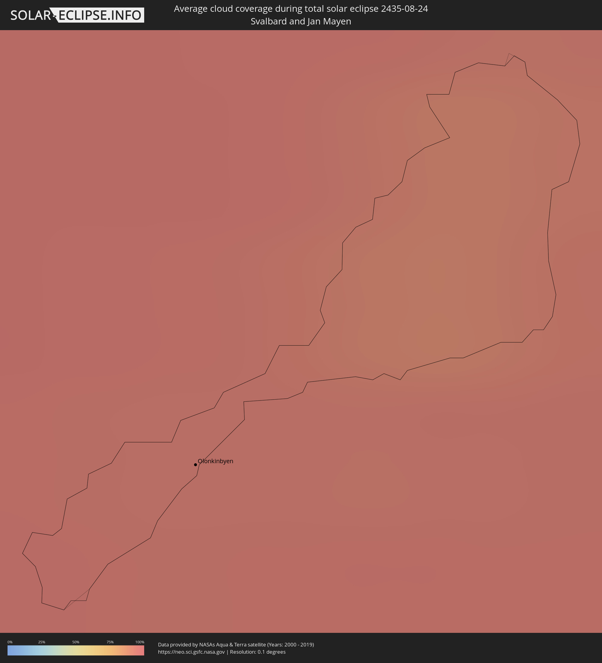
Olonkinbyen, Jan Mayen
|
total | - | 09:36:07 UTC+01:00 | 119 km | 94% |
|
Harstad, Troms
|
total | - | 09:46:14 UTC+01:00 | 82 km | 78% |
|
Narvik, Nordland
|
total | - | 09:46:38 UTC+01:00 | 103 km | 77% |
|
Tromsø, Troms
|
total | - | 09:47:57 UTC+01:00 | 45 km | 77% |
|
Kiruna, Norrbotten
|
total | - | 09:48:12 UTC+01:00 | 108 km | 76% |
|
Kittilä, Lapland
|
total | - | 10:51:13 UTC+02:00 | 27 km | 79% |
|
Rovaniemi, Lapland
|
total | - | 10:51:43 UTC+02:00 | 119 km | 74% |
|
Sodankylä, Lapland
|
total | - | 10:52:21 UTC+02:00 | 12 km | 76% |
|
Inari, Lapland
|
total | - | 10:52:42 UTC+02:00 | 136 km | 81% |
|
Pyhäjärvi, Lapland
|
total | - | 10:52:47 UTC+02:00 | 29 km | 75% |
|
Kemijärvi, Lapland
|
total | - | 10:52:56 UTC+02:00 | 62 km | 75% |
|
Kuusamo, Northern Ostrobothnia
|
total | - | 10:54:15 UTC+02:00 | 82 km | 75% |
|
Severodvinsk, Arkhangelskaya
|
total | - | 12:02:54 UTC+03:00 | 111 km | 76% |
|
Arkhangel’sk, Arkhangelskaya
|
total | - | 12:03:29 UTC+03:00 | 132 km | 75% |
|
Kirov, Kirov
|
total | - | 12:16:16 UTC+03:00 | 33 km | 70% |
|
Nizhnekamsk, Tatarstan
|
total | - | 12:21:47 UTC+03:00 | 76 km | 69% |
|
Naberezhnyye Chelny, Tatarstan
|
total | - | 12:22:15 UTC+03:00 | 41 km | 68% |
|
Izhevsk, Udmurtiya
|
total | - | 13:21:38 UTC+04:00 | 75 km | 74% |
|
Sterlitamak, Bashkortostan
|
total | - | 14:28:36 UTC+05:00 | 5 km | 69% |
|
Ufa, Bashkortostan
|
total | - | 14:27:04 UTC+05:00 | 71 km | 65% |
|
Orsk, Orenburg
|
total | - | 14:34:51 UTC+05:00 | 21 km | 54% |
|
Magnitogorsk, Chelyabinsk
|
total | - | 14:31:58 UTC+05:00 | 148 km | 65% |
|
Aral, Qyzylorda
|
total | - | 14:45:16 UTC+05:00 | 123 km | 24% |
|
Baikonur, Baikonur
|
total | - | 14:49:01 UTC+05:00 | 96 km | 17% |
|
Kyzyl-Orda, Qyzylorda
|
total | - | 14:52:35 UTC+05:00 | 5 km | 13% |
|
Shīeli, Qyzylorda
|
total | - | 14:55:01 UTC+05:00 | 33 km | 12% |
|
Jizzax, Jizzax
|
total | - | 15:03:38 UTC+05:00 | 156 km | 11% |
|
Chardara, Ongtüstik Qazaqstan
|
total | - | 15:01:36 UTC+05:00 | 72 km | 10% |
|
Turkestan, Ongtüstik Qazaqstan
|
total | - | 14:58:03 UTC+05:00 | 78 km | 11% |
|
Kentau, Ongtüstik Qazaqstan
|
total | - | 14:57:53 UTC+05:00 | 109 km | 11% |
|
Arys, Ongtüstik Qazaqstan
|
total | - | 15:00:11 UTC+05:00 | 60 km | 12% |
|
Istaravshan, Viloyati Sughd
|
total | - | 15:05:07 UTC+05:00 | 90 km | 12% |
|
Yangiyŭl, Toshkent
|
total | - | 15:02:53 UTC+05:00 | 9 km | 14% |
|
Tashkent, Toshkent Shahri
|
total | - | 15:02:45 UTC+05:00 | 13 km | 13% |
|
Bekobod, Toshkent
|
total | - | 15:04:47 UTC+05:00 | 52 km | 15% |
|
Bŭston, Viloyati Sughd
|
total | - | 15:04:16 UTC+05:00 | 28 km | 14% |
|
Proletar, Viloyati Sughd
|
total | - | 15:05:05 UTC+05:00 | 40 km | 16% |
|
Isfana, Batken
|
total | - | 16:05:44 UTC+06:00 | 60 km | 20% |
|
Suluktu, Batken
|
total | - | 16:05:35 UTC+06:00 | 50 km | 15% |
|
Chirchiq, Toshkent
|
total | - | 15:02:42 UTC+05:00 | 51 km | 15% |
|
Olmaliq, Toshkent
|
total | - | 15:03:54 UTC+05:00 | 12 km | 11% |
|
Shymkent, Ongtüstik Qazaqstan
|
total | - | 15:01:09 UTC+05:00 | 105 km | 18% |
|
Khŭjand, Viloyati Sughd
|
total | - | 15:04:59 UTC+05:00 | 24 km | 12% |
|
Belyye Vody, Ongtüstik Qazaqstan
|
total | - | 15:01:08 UTC+05:00 | 128 km | 16% |
|
Adrasmon, Viloyati Sughd
|
total | - | 15:04:37 UTC+05:00 | 25 km | 11% |
|
Mŭ’minobod, Khatlon
|
total | - | 15:09:30 UTC+05:00 | 141 km | 10% |
|
Angren, Toshkent
|
total | - | 15:04:04 UTC+05:00 | 60 km | 14% |
|
Konibodom, Viloyati Sughd
|
total | - | 15:05:41 UTC+05:00 | 33 km | 16% |
|
Isfara, Viloyati Sughd
|
total | - | 15:06:11 UTC+05:00 | 35 km | 15% |
|
Batken, Batken
|
total | - | 16:06:29 UTC+06:00 | 44 km | 15% |
|
Qo‘qon, Fergana
|
total | - | 15:05:42 UTC+05:00 | 83 km | 18% |
|
Chust Shahri, Namangan
|
total | - | 15:05:03 UTC+05:00 | 134 km | 17% |
|
Aydarken, Batken
|
total | - | 16:07:10 UTC+06:00 | 72 km | 37% |
|
Ashkāsham, Badakhshan
|
total | - | 14:43:34 UTC+04:30 | 135 km | 12% |
|
Khorugh, Gorno-Badakhshan
|
total | - | 15:12:02 UTC+05:00 | 78 km | 14% |
|
Ishqoshim, Gorno-Badakhshan
|
total | - | 15:13:33 UTC+05:00 | 127 km | 14% |
|
Fergana, Fergana
|
total | - | 15:06:43 UTC+05:00 | 131 km | 16% |
|
Iradan, Batken
|
total | - | 16:07:12 UTC+06:00 | 145 km | 15% |
|
Kyzyl-Kyya, Batken
|
total | - | 16:07:15 UTC+06:00 | 147 km | 15% |
|
Khandūd, Badakhshan
|
total | - | 14:43:43 UTC+04:30 | 62 km | 16% |
|
Gilgit, Gilgit-Baltistan
|
total | - | 15:17:21 UTC+05:00 | 5 km | 60% |
|
Srinagar, Kashmir
|
total | - | 15:51:14 UTC+05:30 | 93 km | 38% |
|
Dehra Dūn, Uttarakhand
|
total | - | 16:00:40 UTC+05:30 | 158 km | 88% |
|
Mahendranagar, Far Western
|
total | - | 16:19:42 UTC+05:45 | 119 km | 88% |
|
Dhangarhi, Far Western
|
total | - | 16:20:14 UTC+05:45 | 119 km | 88% |
|
Burang, Tibet Autonomous Region
|
total | - | 18:32:41 UTC+08:00 | 49 km | 46% |
|
Gorakhpur, Uttar Pradesh
|
total | - | 16:10:13 UTC+05:30 | 107 km | 89% |
|
Butwāl, Western Region
|
total | - | 16:23:36 UTC+05:45 | 21 km | 90% |
|
Pokhara, Western Region
|
total | - | 16:22:52 UTC+05:45 | 60 km | 89% |
|
Bharatpur, Central Region
|
total | - | 16:24:07 UTC+05:45 | 39 km | 89% |
|
Arrah, Bihar
|
total | - | 16:12:56 UTC+05:30 | 135 km | 95% |
|
Bīrganj, Central Region
|
total | - | 16:25:31 UTC+05:45 | 7 km | 89% |
|
Patna, Bihar
|
total | - | 16:13:04 UTC+05:30 | 103 km | 93% |
|
Kathmandu, Central Region
|
total | - | 16:24:30 UTC+05:45 | 95 km | 87% |
|
Muzaffarpur, Bihar
|
total | - | 16:12:17 UTC+05:30 | 41 km | 94% |
|
Bihār Sharīf, Bihar
|
total | - | 16:13:55 UTC+05:30 | 116 km | 96% |
|
Darbhanga, Bihar
|
total | - | 16:12:27 UTC+05:30 | 8 km | 94% |
|
Janakpur, Central Region
|
total | - | 16:26:29 UTC+05:45 | 43 km | 94% |
|
Bhāgalpur, Bihar
|
total | - | 16:14:26 UTC+05:30 | 27 km | 96% |
|
Biratnagar, Eastern Region
|
total | - | 16:27:30 UTC+05:45 | 100 km | 94% |
|
Dharān Bāzār, Eastern Region
|
total | - | 16:26:53 UTC+05:45 | 133 km | 94% |
|
Rājshāhi, Rājshāhi
|
total | - | 16:46:28 UTC+06:00 | 16 km | 96% |
|
Jessore, Khulna
|
total | - | 16:48:38 UTC+06:00 | 97 km | 97% |
|
Rangpur, Rangpur Division
|
total | - | 16:44:25 UTC+06:00 | 147 km | 95% |
|
Khulna, Khulna
|
total | - | 16:49:19 UTC+06:00 | 113 km | 96% |
|
Tungi, Dhaka
|
total | - | 16:47:49 UTC+06:00 | 34 km | 96% |
|
Dhaka, Dhaka
|
total | - | 16:48:07 UTC+06:00 | 17 km | 94% |
|
Narsingdi, Dhaka
|
total | - | 16:47:52 UTC+06:00 | 54 km | 93% |
|
Comilla, Chittagong
|
total | - | 16:48:43 UTC+06:00 | 34 km | 97% |
|
Chittagong, Chittagong
|
total | - | 16:50:40 UTC+06:00 | 43 km | 90% |
|
Cox’s Bāzār, Chittagong
|
total | - | 16:52:06 UTC+06:00 | 123 km | 87% |
|
Aizawl, Mizoram
|
total | - | 16:18:41 UTC+05:30 | 136 km | 88% |
|
Yenangyaung, Magway
|
total | - | 17:24:04 UTC+06:30 | 88 km | 95% |
|
Magway, Magway
|
total | - | 17:24:33 UTC+06:30 | 118 km | 96% |
|
Pakokku, Magway
|
total | - | 17:22:48 UTC+06:30 | 9 km | 97% |
|
Monywa, Sagain
|
total | - | 17:21:39 UTC+06:30 | 89 km | 96% |
|
Myingyan, Mandalay
|
total | - | 17:22:39 UTC+06:30 | 35 km | 95% |
|
Meiktila, Mandalay
|
total | - | 17:23:35 UTC+06:30 | 4 km | 96% |
|
Mandalay, Mandalay
|
total | - | 17:21:59 UTC+06:30 | 117 km | 96% |
|
Nay Pyi Taw, Nay Pyi Taw
|
total | - | 17:25:16 UTC+06:30 | 108 km | 97% |
|
Pyin Oo Lwin, Mandalay
|
total | - | 17:21:56 UTC+06:30 | 139 km | 96% |
|
Taunggyi, Shan
|
total | - | 17:23:50 UTC+06:30 | 36 km | 94% |
|
Chiang Mai, Chiang Mai
|
total | - | 17:56:47 UTC+07:00 | 95 km | 96% |
|
Lamphun, Lamphun
|
total | - | 17:57:04 UTC+07:00 | 116 km | 95% |
|
Lampang, Lampang
|
total | - | 17:57:28 UTC+07:00 | 129 km | 95% |
|
Chiang Rai, Chiang Rai
|
total | - | 17:55:14 UTC+07:00 | 53 km | 95% |
|
Mae Chan, Chiang Rai
|
total | - | 17:54:54 UTC+07:00 | 78 km | 94% |
|
Phrae, Phrae
|
total | - | 17:57:40 UTC+07:00 | 121 km | 95% |
|
Ban Houayxay, Bokeo Province
|
total | - | 17:54:43 UTC+07:00 | 112 km | 89% |
|
Ban Houakhoua, Bokeo Province
|
total | - | 17:54:46 UTC+07:00 | 110 km | 89% |
|
Sainyabuli, Xiagnabouli
|
total | - | 17:56:06 UTC+07:00 | 49 km | 88% |
|
Luang Prabang, Louangphabang
|
total | - | 17:55:14 UTC+07:00 | 130 km | 86% |
|
Muang Phôn-Hông, Vientiane Province
|
total | - | 17:57:06 UTC+07:00 | 9 km | 91% |
|
Vangviang, Vientiane Province
|
total | - | 17:56:31 UTC+07:00 | 38 km | 89% |
|
Tha Bo, Nong Khai
|
total | - | 17:57:57 UTC+07:00 | 72 km | 90% |
|
Vientiane, Vientiane
|
total | - | 17:57:47 UTC+07:00 | 59 km | 93% |
|
Nong Khai, Nong Khai
|
total | - | 17:57:54 UTC+07:00 | 64 km | 92% |
|
Udon Thani, Changwat Udon Thani
|
total | - | 17:58:30 UTC+07:00 | 112 km | 93% |
|
Muang Phônsavan, Xiangkhoang
|
total | - | 17:55:46 UTC+07:00 | 118 km | 91% |
|
Muang Pakxan, Bolikhamsai Province
|
total | - | 17:57:09 UTC+07:00 | 18 km | 85% |
|
Sakon Nakhon, Sakon Nakhon
|
total | - | 17:58:41 UTC+07:00 | 99 km | 91% |
|
Thakhèk, Khammouan
|
total | - | 17:58:17 UTC+07:00 | 53 km | 89% |
|
Yên Vinh, Nghệ An
|
total | - | 17:56:33 UTC+07:00 | 105 km | 88% |
|
Vinh, Nghệ An
|
total | - | 17:56:33 UTC+07:00 | 107 km | 88% |
|
Hà Tĩnh, Hà Tĩnh
|
total | - | 17:56:56 UTC+07:00 | 77 km | 85% |
|
Kwang Binh, Quảng Bình
|
total | - | 17:57:57 UTC+07:00 | 1 km | 83% |
|
Ðông Hà, Quảng Trị
|
total | - | 17:58:40 UTC+07:00 | 57 km | 83% |
|
Huế, Thừa Thiên-Huế
|
total | - | 17:59:01 UTC+07:00 | 84 km | 82% |
|
Da Nang, Đà Nẵng
|
total | - | 17:59:22 UTC+07:00 | 112 km | 85% |
|
Hội An, Quảng Nam
|
total | - | 17:59:34 UTC+07:00 | 130 km | 78% |