Totale Sonnenfinsternis vom 26.10.2497
| Wochentag: | Samstag |
| Maximale Dauer der Verfinsterung: | 04m06s |
| Maximale Breite des Finsternispfades: | 164 km |
| Saroszyklus: | 151 |
| Bedeckungsgrad: | 100% |
| Magnitude: | 1.0472 |
| Gamma: | -0.2889 |
Wo kann man die Sonnenfinsternis vom 26.10.2497 sehen?
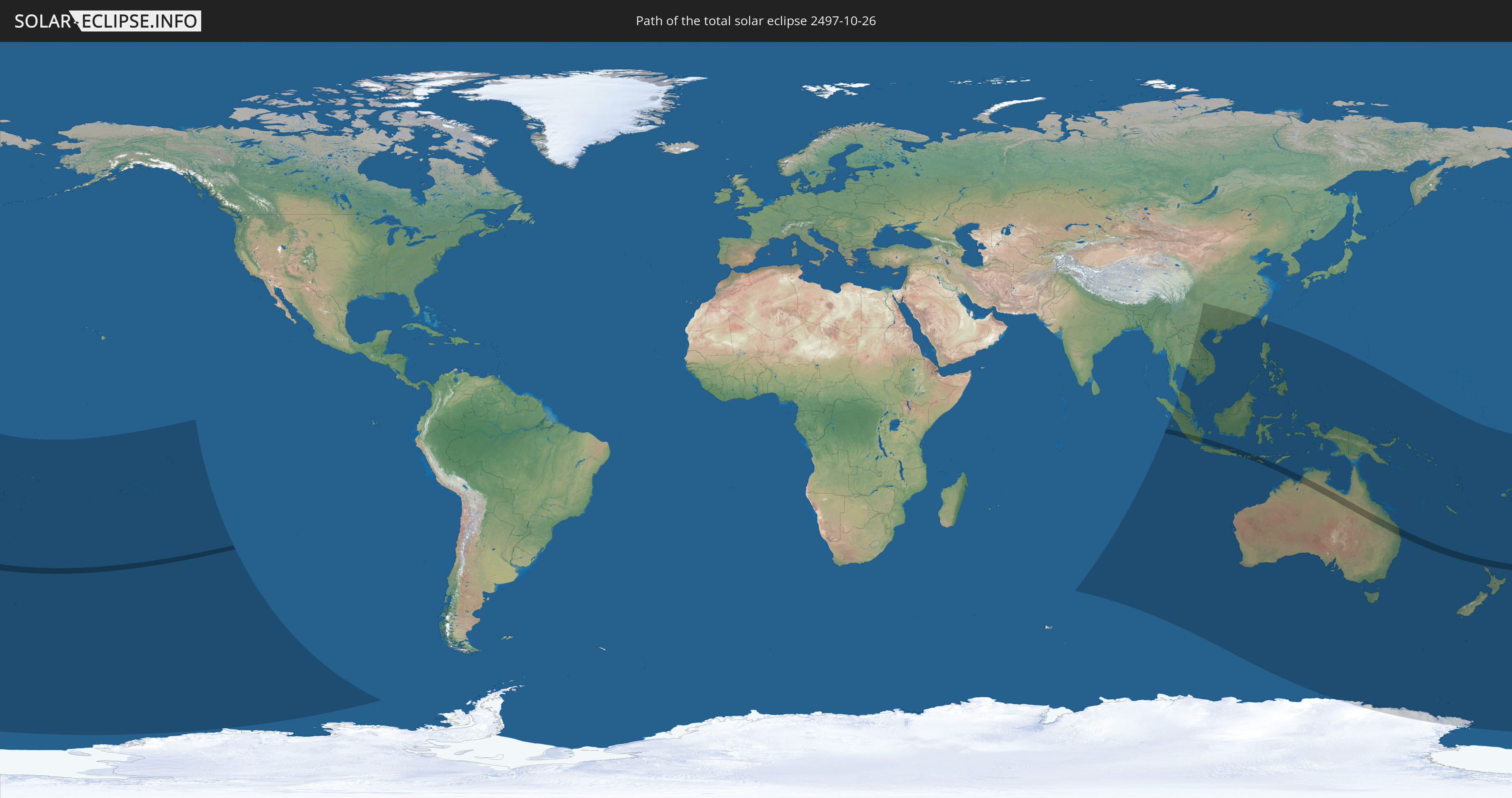
Die Sonnenfinsternis am 26.10.2497 kann man in 41 Ländern als partielle Sonnenfinsternis beobachten.
Der Finsternispfad verläuft durch 3 Länder. Nur in diesen Ländern ist sie als totale Sonnenfinsternis zu sehen.
In den folgenden Ländern ist die Sonnenfinsternis total zu sehen
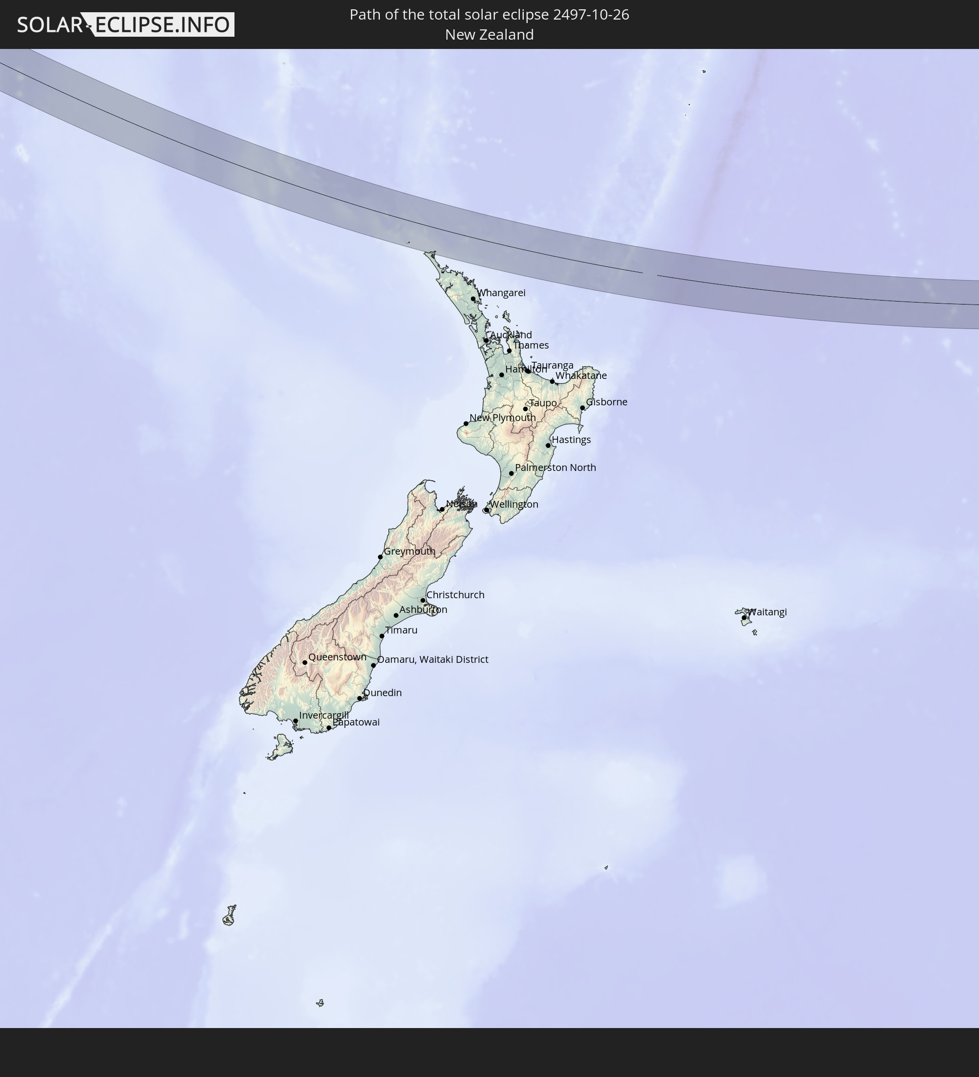 Neuseeland
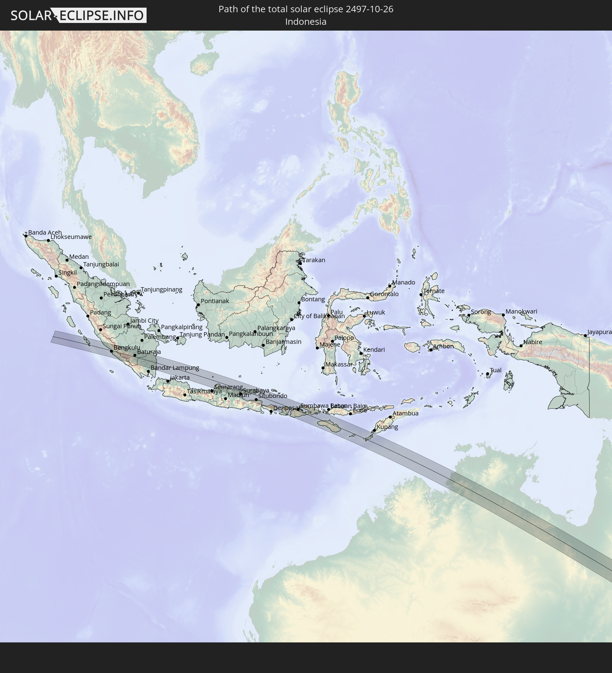 Indonesien
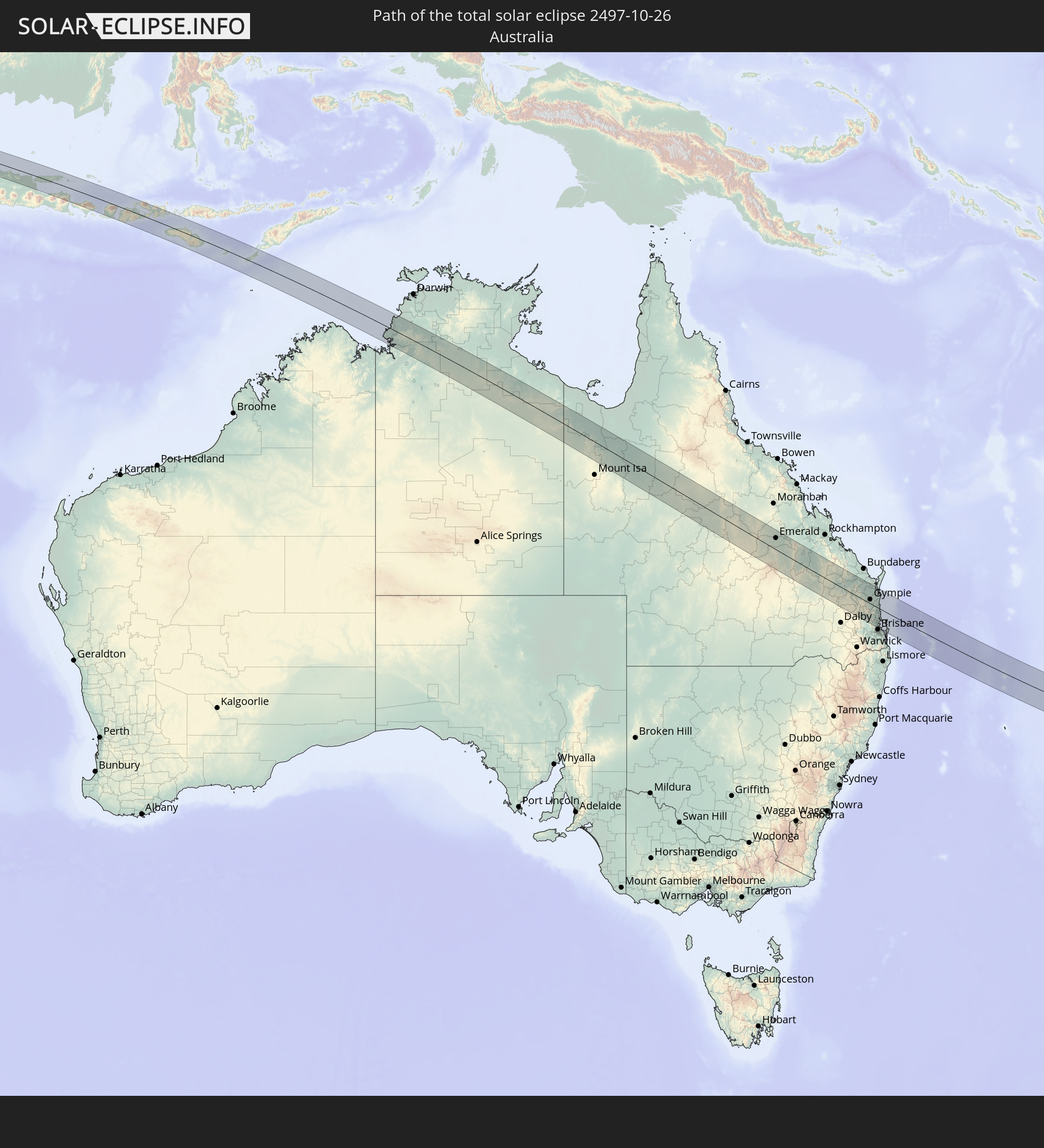 Australien
In den folgenden Ländern ist die Sonnenfinsternis partiell zu sehen
 Antarktika
 Fidschi
 Neuseeland
 Wallis und Futuna
 Tonga
Tonga
 Kiribati
 Samoa
Samoa
 Tokelau
 Amerikanisch-Samoa
 Niue
Niue
 Cookinseln
 Französisch-Polynesien
 Pitcairninseln
 Französische Süd- und Antarktisgebiete
 Volksrepublik China
 Indonesien
 Kokosinseln
 Thailand
 Malaysia
 Laos
Laos
 Vietnam
 Kambodscha
 Singapur
 Weihnachtsinsel
 Australien
 Macau
Macau
 Hongkong
 Brunei
 Taiwan
 Philippinen
 Osttimor
 Palau
Palau
 Föderierte Staaten von Mikronesien
 Papua-Neuguinea
 Guam
Guam
 Salomonen
 Neukaledonien
 Vanuatu
 Nauru
Nauru
 Norfolkinsel
 Tuvalu
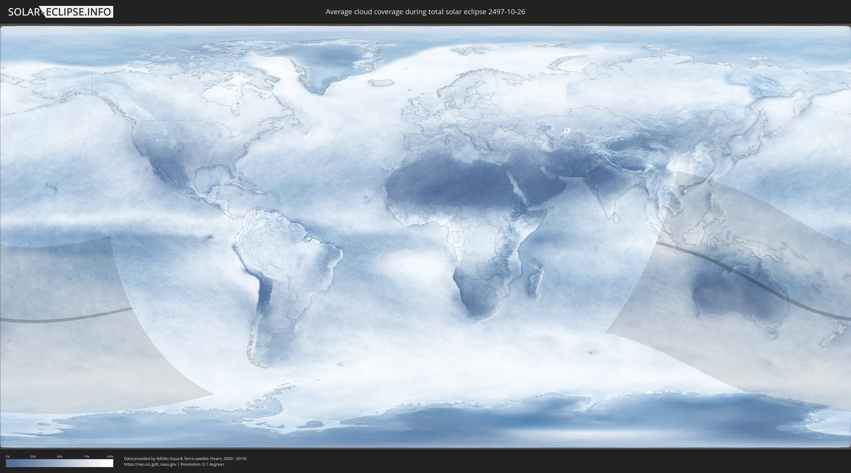
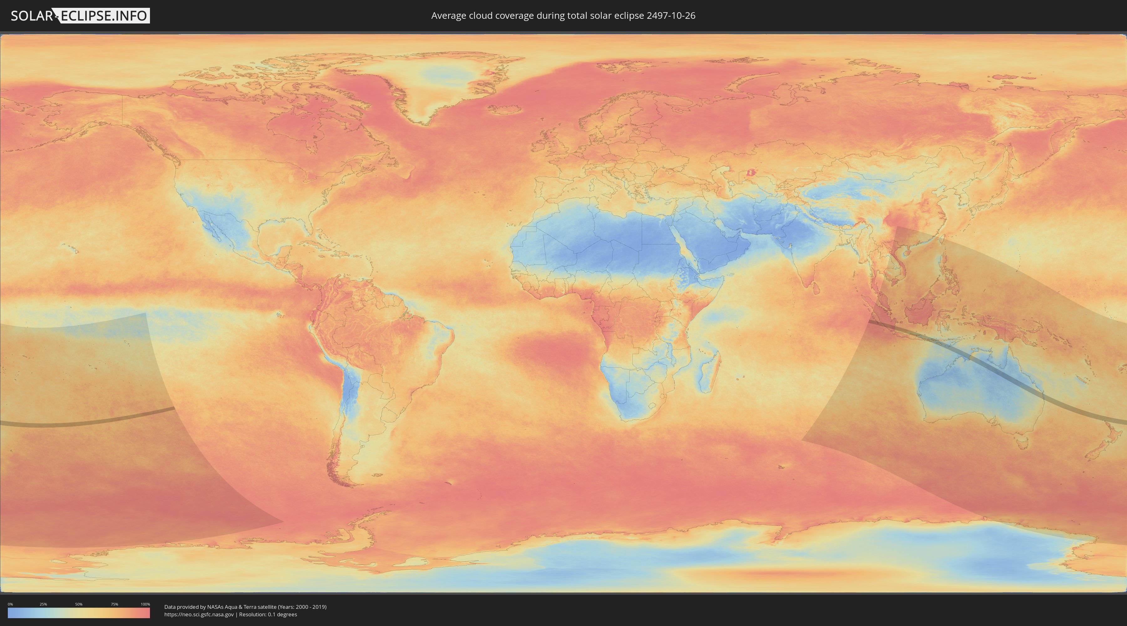
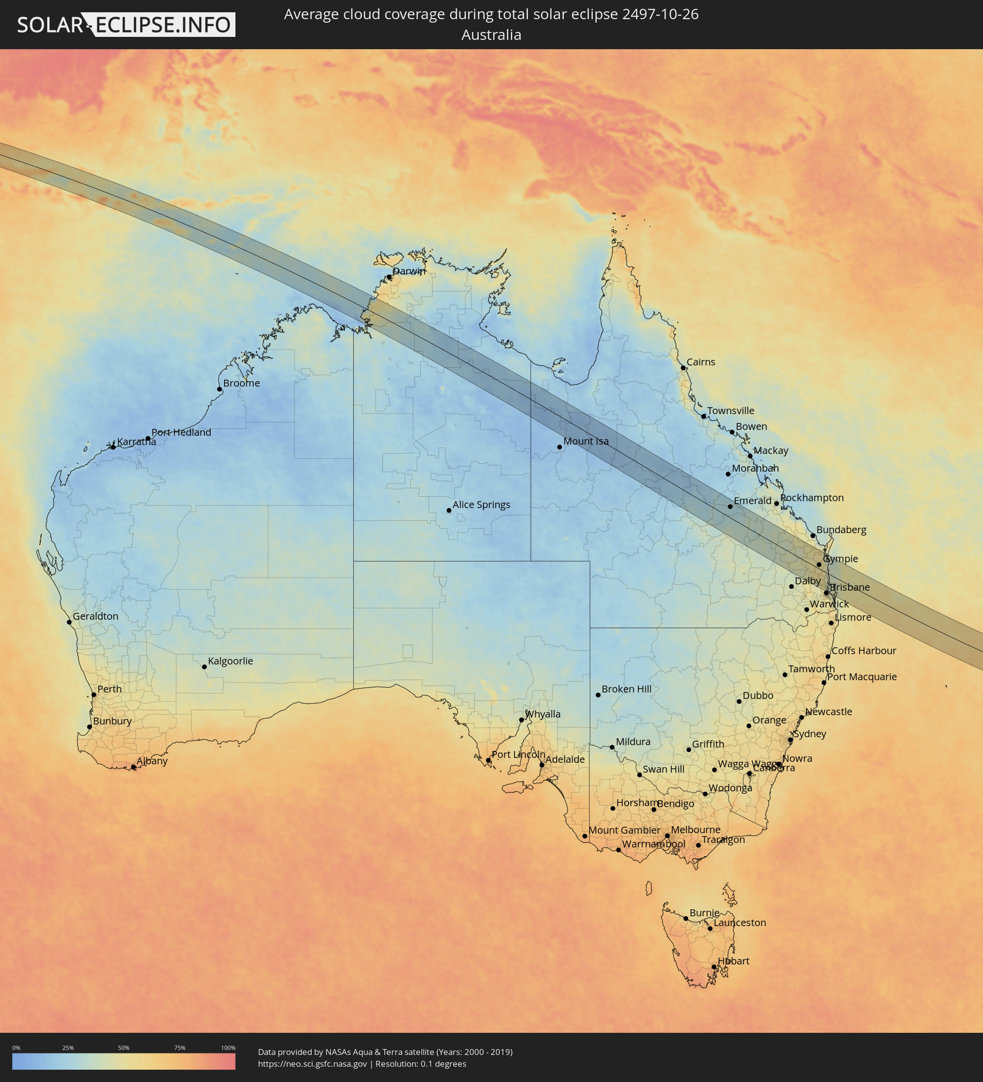
Wie wird das Wetter während der totalen Sonnenfinsternis am 26.10.2497?
Wo ist der beste Ort, um die totale Sonnenfinsternis vom 26.10.2497 zu beobachten?
Die folgenden Karten zeigen die durchschnittliche Bewölkung für den Tag, an dem die totale Sonnenfinsternis
stattfindet. Mit Hilfe der Karten lässt sich der Ort entlang des Finsternispfades eingrenzen,
der die besten Aussichen auf einen klaren wolkenfreien Himmel bietet.
Trotzdem muss man immer lokale Gegenenheiten beachten und sollte sich genau über das Wetter an seinem
gewählten Beobachtungsort informieren.
Die Daten stammen von den beiden NASA-Satelliten
AQUA und TERRA
und wurden über einen Zeitraum von 19 Jahren (2000 - 2019) gemittelt.
Detaillierte Länderkarten
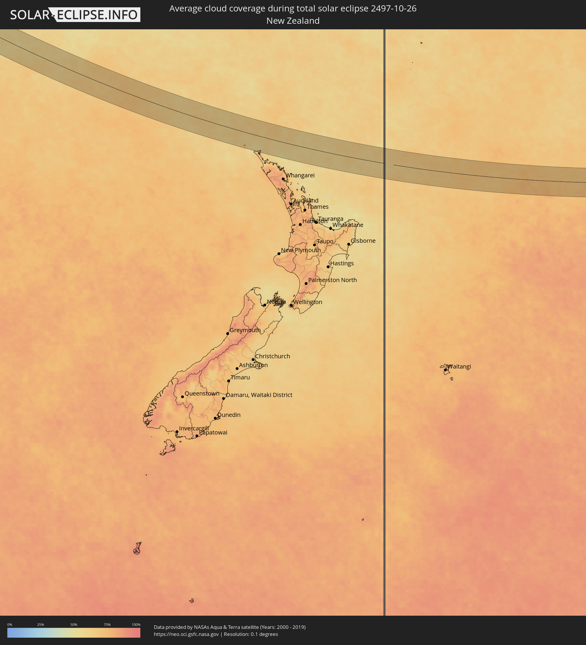 Neuseeland
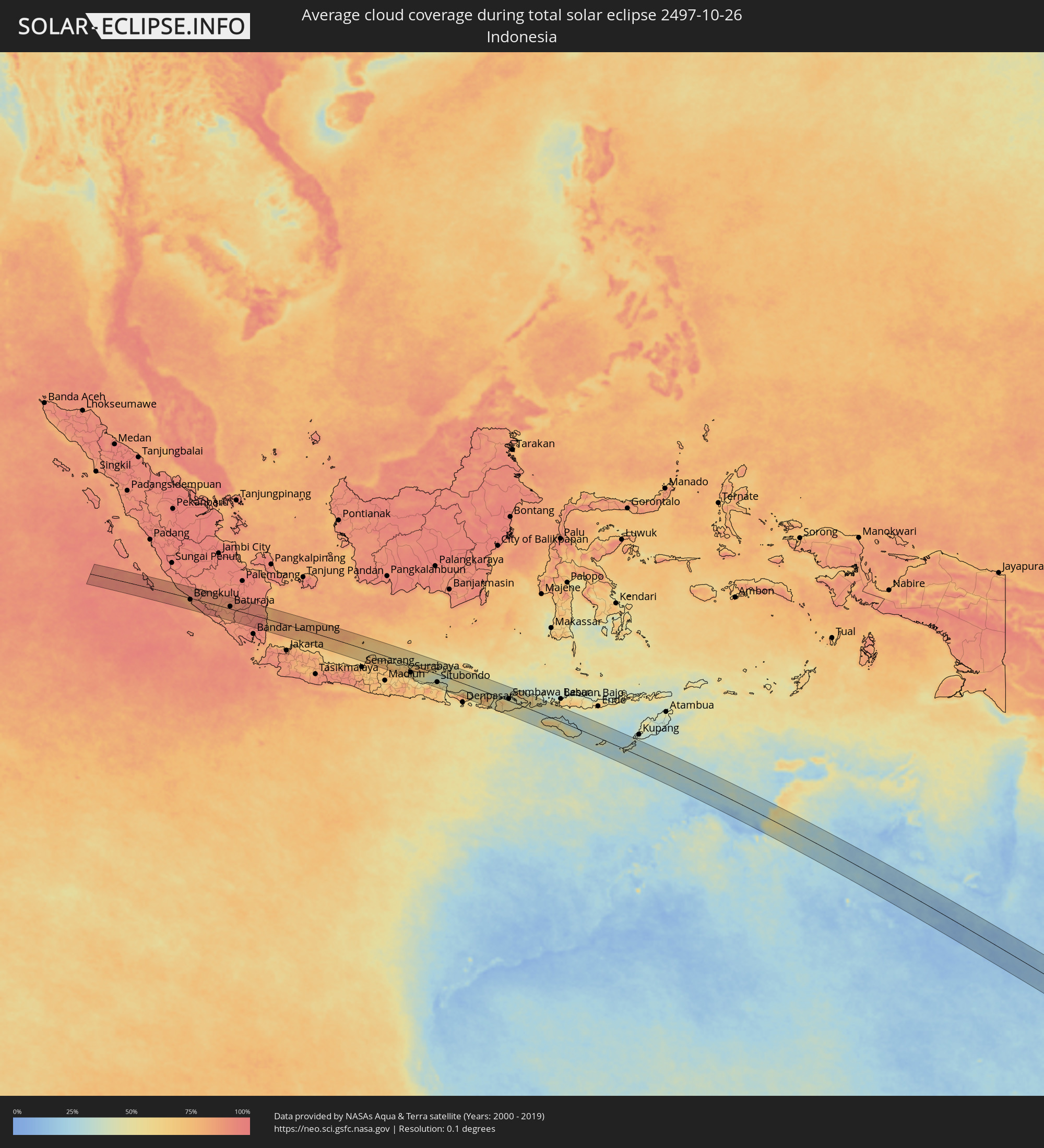 Indonesien
 Australien
Orte im Finsternispfad
Die nachfolgene Tabelle zeigt Städte und Orte mit mehr als 5.000 Einwohnern, die sich im Finsternispfad befinden. Städte mit mehr als 100.000 Einwohnern sind dick gekennzeichnet. Mit einem Klick auf den Ort öffnet sich eine Detailkarte die die Lage des jeweiligen Ortes zusammen mit dem Verlauf der zentralen Finsternis präsentiert.
| Ort | Typ | Dauer der Verfinsterung | Ortszeit bei maximaler Verfinsterung | Entfernung zur Zentrallinie | Ø Bewölkung |
|
Bengkulu, Bengkulu
|
total | - | 06:12:02 UTC+07:00 | 8 km | 88% |
|
Curup, Bengkulu
|
total | - | 06:11:47 UTC+07:00 | 35 km | 91% |
|
Pagar Alam, South Sumatra
|
total | - | 06:12:12 UTC+07:00 | 4 km | 87% |
|
Lahat, South Sumatra
|
total | - | 06:12:02 UTC+07:00 | 30 km | 85% |
|
Tanjungagung, South Sumatra
|
total | - | 06:12:09 UTC+07:00 | 21 km | 85% |
|
Baturaja, South Sumatra
|
total | - | 06:12:18 UTC+07:00 | 11 km | 89% |
|
Kotabumi, Lampung
|
total | - | 06:12:53 UTC+07:00 | 42 km | 92% |
|
Terbanggi Besar, Lampung
|
total | - | 06:12:57 UTC+07:00 | 38 km | 94% |
|
Metro, Lampung
|
total | - | 06:13:09 UTC+07:00 | 60 km | 94% |
|
Mlonggo, Central Java
|
total | - | 06:15:20 UTC+07:00 | 36 km | 76% |
|
Batang, Central Java
|
total | - | 06:15:17 UTC+07:00 | 31 km | 76% |
|
Pecangaan, Central Java
|
total | - | 06:15:29 UTC+07:00 | 53 km | 78% |
|
Welahan, Central Java
|
total | - | 06:15:34 UTC+07:00 | 64 km | 73% |
|
Kudus, Central Java
|
total | - | 06:15:37 UTC+07:00 | 60 km | 73% |
|
Gebog, Central Java
|
total | - | 06:15:33 UTC+07:00 | 52 km | 76% |
|
Baekrajan, Central Java
|
total | - | 06:15:35 UTC+07:00 | 55 km | 73% |
|
Jekulo, Central Java
|
total | - | 06:15:38 UTC+07:00 | 57 km | 73% |
|
Pati, Central Java
|
total | - | 06:15:37 UTC+07:00 | 48 km | 75% |
|
Tayu, Central Java
|
total | - | 06:15:26 UTC+07:00 | 25 km | 64% |
|
Juwana, Central Java
|
total | - | 06:15:37 UTC+07:00 | 40 km | 76% |
|
Rembangan, Central Java
|
total | - | 06:15:40 UTC+07:00 | 32 km | 74% |
|
Blora, Central Java
|
total | - | 06:15:56 UTC+07:00 | 57 km | 76% |
|
Lasem, Central Java
|
total | - | 06:15:41 UTC+07:00 | 27 km | 71% |
|
Bojonegoro, East Java
|
total | - | 06:16:14 UTC+07:00 | 60 km | 70% |
|
Tuban, East Java
|
total | - | 06:16:04 UTC+07:00 | 27 km | 67% |
|
Babat, East Java
|
total | - | 06:16:18 UTC+07:00 | 46 km | 73% |
|
Paciran, East Java
|
total | - | 06:16:09 UTC+07:00 | 13 km | 67% |
|
Lamongan, East Java
|
total | - | 06:16:23 UTC+07:00 | 37 km | 72% |
|
Krian, East Java
|
total | - | 06:16:43 UTC+07:00 | 62 km | 62% |
|
Driyorejo, East Java
|
total | - | 06:16:41 UTC+07:00 | 56 km | 62% |
|
Kebomas, East Java
|
total | - | 06:16:30 UTC+07:00 | 34 km | 66% |
|
Gresik, East Java
|
total | - | 06:16:30 UTC+07:00 | 32 km | 63% |
|
Sidoarjo, East Java
|
total | - | 06:16:48 UTC+07:00 | 61 km | 61% |
|
Kamal, East Java
|
total | - | 06:16:32 UTC+07:00 | 31 km | 63% |
|
Buduran, East Java
|
total | - | 06:16:47 UTC+07:00 | 59 km | 61% |
|
Gedangan, East Java
|
total | - | 06:16:45 UTC+07:00 | 55 km | 61% |
|
Bangkalan, East Java
|
total | - | 06:16:26 UTC+07:00 | 18 km | 71% |
|
Surabaya, East Java
|
total | - | 06:16:38 UTC+07:00 | 39 km | 57% |
|
Sampang, East Java
|
total | - | 06:16:45 UTC+07:00 | 14 km | 60% |
|
Pamekasan, East Java
|
total | - | 06:16:48 UTC+07:00 | 3 km | 53% |
|
Besuki, East Java
|
total | - | 06:17:26 UTC+07:00 | 55 km | 56% |
|
Sumenep, East Java
|
total | - | 06:16:49 UTC+07:00 | 27 km | 56% |
|
Balung, East Java
|
total | - | 06:17:32 UTC+07:00 | 47 km | 55% |
|
Panarukan, East Java
|
total | - | 06:17:30 UTC+07:00 | 43 km | 55% |
|
Kalianget, East Java
|
total | - | 06:16:53 UTC+07:00 | 25 km | 52% |
|
Situbondo, East Java
|
total | - | 06:17:32 UTC+07:00 | 40 km | 53% |
|
Panji, East Java
|
total | - | 06:17:36 UTC+07:00 | 39 km | 49% |
|
Wongsorejo, East Java
|
total | - | 06:17:59 UTC+07:00 | 56 km | 46% |
|
Seririt, Bali
|
total | - | 07:18:24 UTC+08:00 | 56 km | 71% |
|
Banjar, Bali
|
total | - | 07:18:25 UTC+08:00 | 55 km | 73% |
|
Munduk, Bali
|
total | - | 07:18:33 UTC+08:00 | 59 km | 82% |
|
Singaraja, Bali
|
total | - | 07:18:24 UTC+08:00 | 42 km | 66% |
|
Karangasem, Bali
|
total | - | 07:18:58 UTC+08:00 | 57 km | 52% |
|
Mataram, West Nusa Tenggara
|
total | - | 07:19:21 UTC+08:00 | 51 km | 66% |
|
Praya, West Nusa Tenggara
|
total | - | 07:19:33 UTC+08:00 | 58 km | 64% |
|
Sumbawa Besar, West Nusa Tenggara
|
total | - | 07:19:55 UTC+08:00 | 10 km | 48% |
|
Dompu, West Nusa Tenggara
|
total | - | 07:20:32 UTC+08:00 | 47 km | 60% |
|
Bima, West Nusa Tenggara
|
total | - | 07:20:37 UTC+08:00 | 66 km | 54% |
|
Waingapu, East Nusa Tenggara
|
total | - | 07:22:52 UTC+08:00 | 7 km | 36% |
|
Emerald, Queensland
|
total | - | 10:20:36 UTC+10:00 | 48 km | 28% |
|
Blackwater, Queensland
|
total | - | 10:22:11 UTC+10:00 | 79 km | 30% |
|
Kingaroy, Queensland
|
total | - | 10:32:57 UTC+10:00 | 58 km | 42% |
|
Gympie, Queensland
|
total | - | 10:34:14 UTC+10:00 | 17 km | 50% |
|
Maryborough, Queensland
|
total | - | 10:33:22 UTC+10:00 | 82 km | 54% |
|
Morayfield, Queensland
|
total | - | 10:36:11 UTC+10:00 | 59 km | 49% |
|
Caboolture, Queensland
|
total | - | 10:36:09 UTC+10:00 | 57 km | 42% |
|
Burpengary, Queensland
|
total | - | 10:36:16 UTC+10:00 | 64 km | 43% |
|
Narangba, Queensland
|
total | - | 10:36:20 UTC+10:00 | 68 km | 43% |
|
Nambour, Queensland
|
total | - | 10:35:31 UTC+10:00 | 12 km | 46% |
|
Strathpine, Queensland
|
total | - | 10:36:33 UTC+10:00 | 76 km | 49% |
|
Bridegman Downs, Queensland
|
total | - | 10:36:38 UTC+10:00 | 81 km | 55% |
|
Bald Hills, Queensland
|
total | - | 10:36:37 UTC+10:00 | 77 km | 49% |
|
Murrumba Downs, Queensland
|
total | - | 10:36:33 UTC+10:00 | 72 km | 49% |
|
Deception Bay, Queensland
|
total | - | 10:36:28 UTC+10:00 | 64 km | 43% |
|
Bracken Ridge, Queensland
|
total | - | 10:36:40 UTC+10:00 | 76 km | 49% |
|
Tewantin, Queensland
|
total | - | 10:35:20 UTC+10:00 | 15 km | 43% |
|
Taigum, Queensland
|
total | - | 10:36:43 UTC+10:00 | 77 km | 49% |
|
Zillmere, Queensland
|
total | - | 10:36:45 UTC+10:00 | 79 km | 55% |
|
Wavell Heights, Queensland
|
total | - | 10:36:48 UTC+10:00 | 82 km | 55% |
|
Buderim, Queensland
|
total | - | 10:35:49 UTC+10:00 | 13 km | 42% |
|
Brighton, Queensland
|
total | - | 10:36:41 UTC+10:00 | 72 km | 44% |
|
Noosaville, Queensland
|
total | - | 10:35:25 UTC+10:00 | 15 km | 41% |
|
Clontarf, Queensland
|
total | - | 10:36:40 UTC+10:00 | 67 km | 44% |
|
Coolum Beach, Queensland
|
total | - | 10:35:39 UTC+10:00 | 4 km | 40% |
|
Little Mountain, Queensland
|
total | - | 10:36:02 UTC+10:00 | 21 km | 43% |
|
Margate, Queensland
|
total | - | 10:36:42 UTC+10:00 | 66 km | 39% |
|
Scarborough, Queensland
|
total | - | 10:36:40 UTC+10:00 | 61 km | 39% |
|
Mooloolaba, Queensland
|
total | - | 10:35:57 UTC+10:00 | 9 km | 42% |
|
Caloundra, Queensland
|
total | - | 10:36:07 UTC+10:00 | 21 km | 43% |
|
Wynnum, Queensland
|
total | - | 10:37:07 UTC+10:00 | 82 km | 44% |
|
Bongaree, Queensland
|
total | - | 10:36:36 UTC+10:00 | 47 km | 40% |
|
Wellington Point, Queensland
|
total | - | 10:37:22 UTC+10:00 | 81 km | 44% |