Totale Sonnenfinsternis vom 10.07.2708
| Wochentag: | Freitag |
| Maximale Dauer der Verfinsterung: | 05m22s |
| Maximale Breite des Finsternispfades: | 302 km |
| Saroszyklus: | 167 |
| Bedeckungsgrad: | 100% |
| Magnitude: | 1.0774 |
| Gamma: | 0.5551 |
Wo kann man die Sonnenfinsternis vom 10.07.2708 sehen?
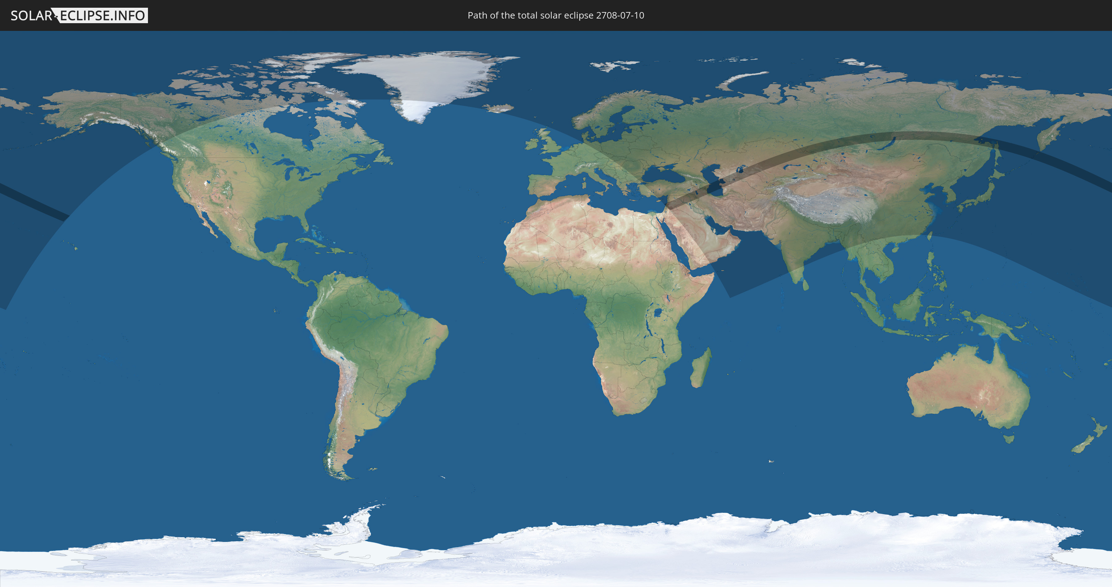
Die Sonnenfinsternis am 10.07.2708 kann man in 67 Ländern als partielle Sonnenfinsternis beobachten.
Der Finsternispfad verläuft durch 13 Länder. Nur in diesen Ländern ist sie als totale Sonnenfinsternis zu sehen.
In den folgenden Ländern ist die Sonnenfinsternis total zu sehen
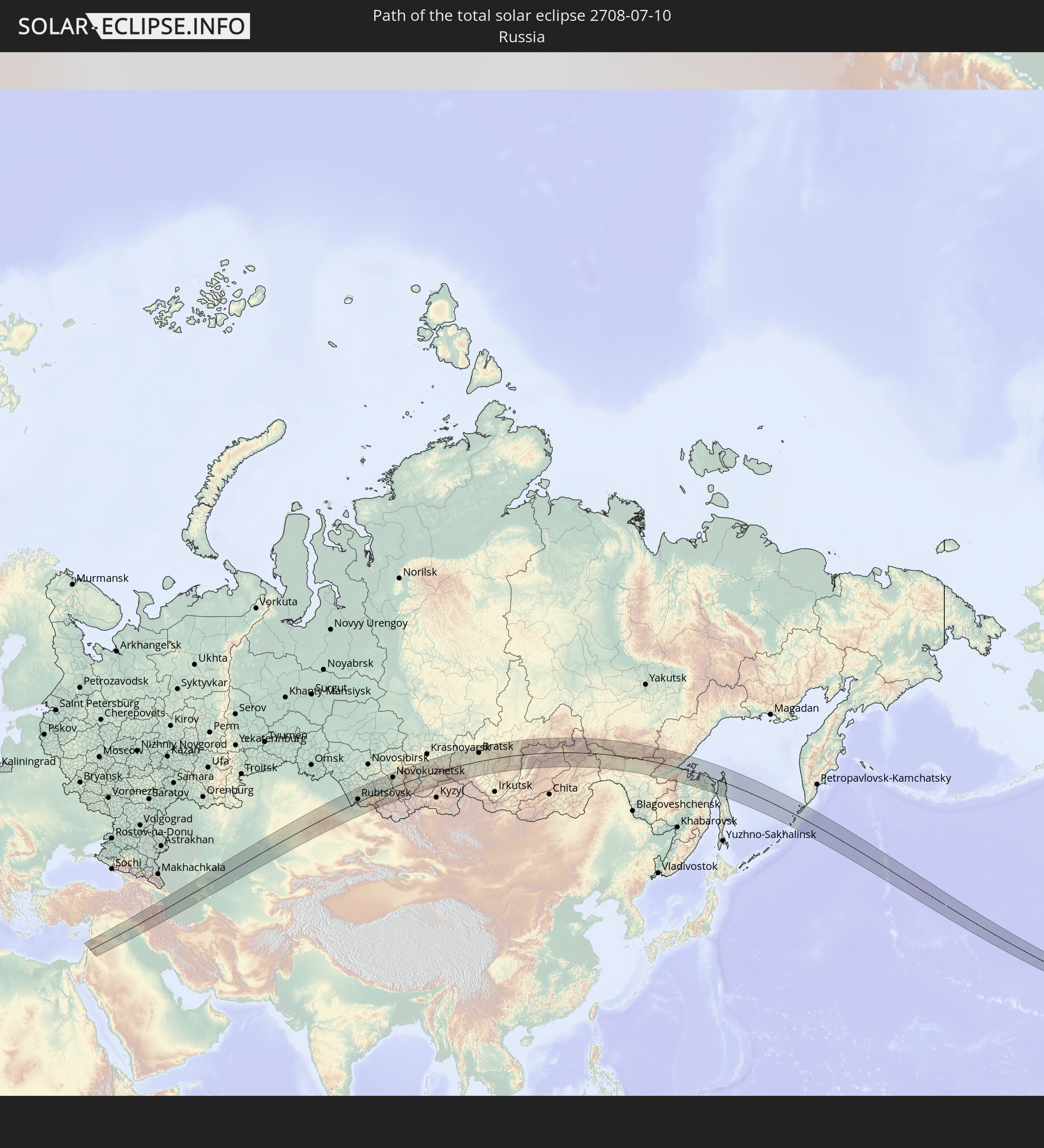 Russland
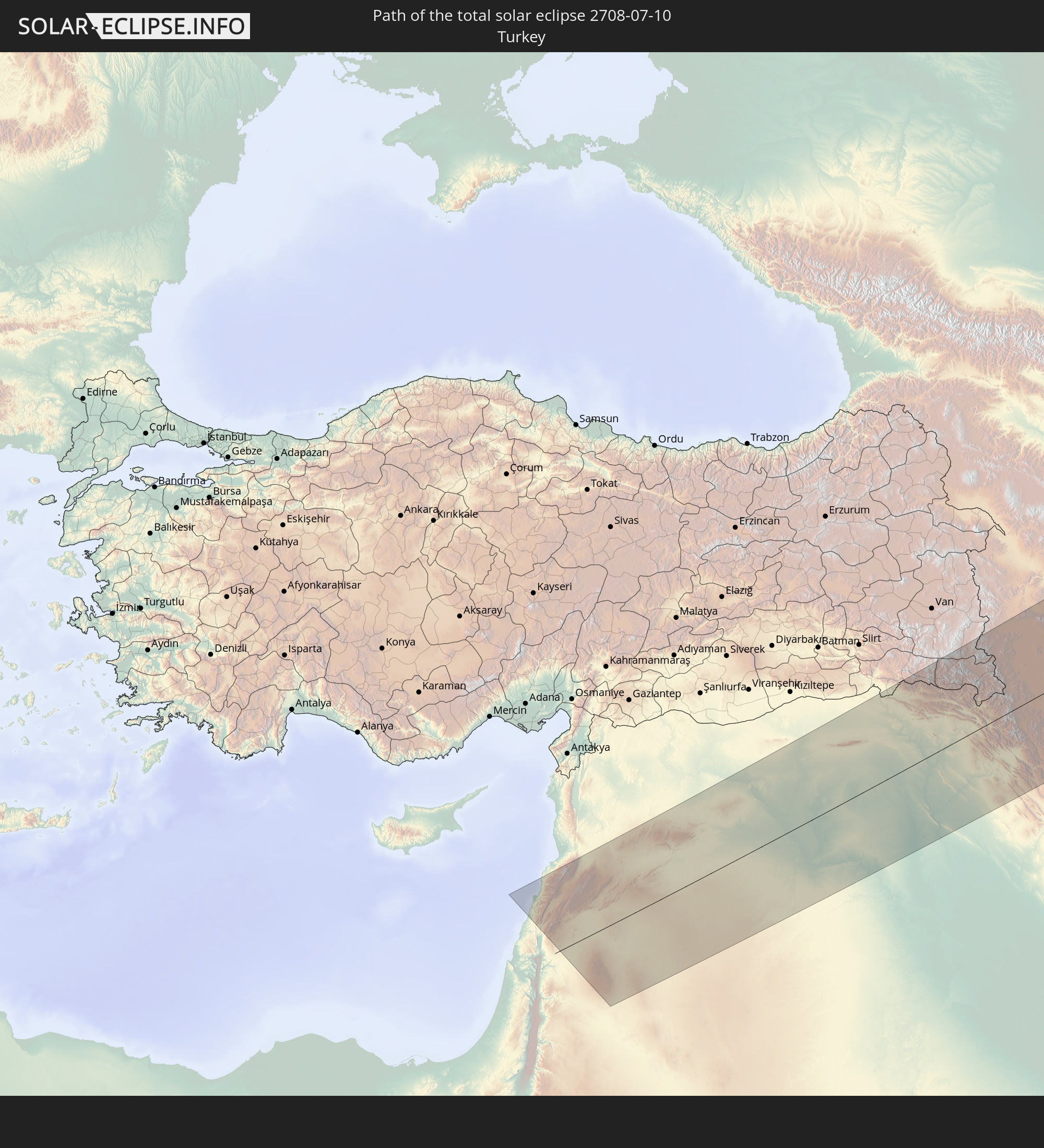 Türkei
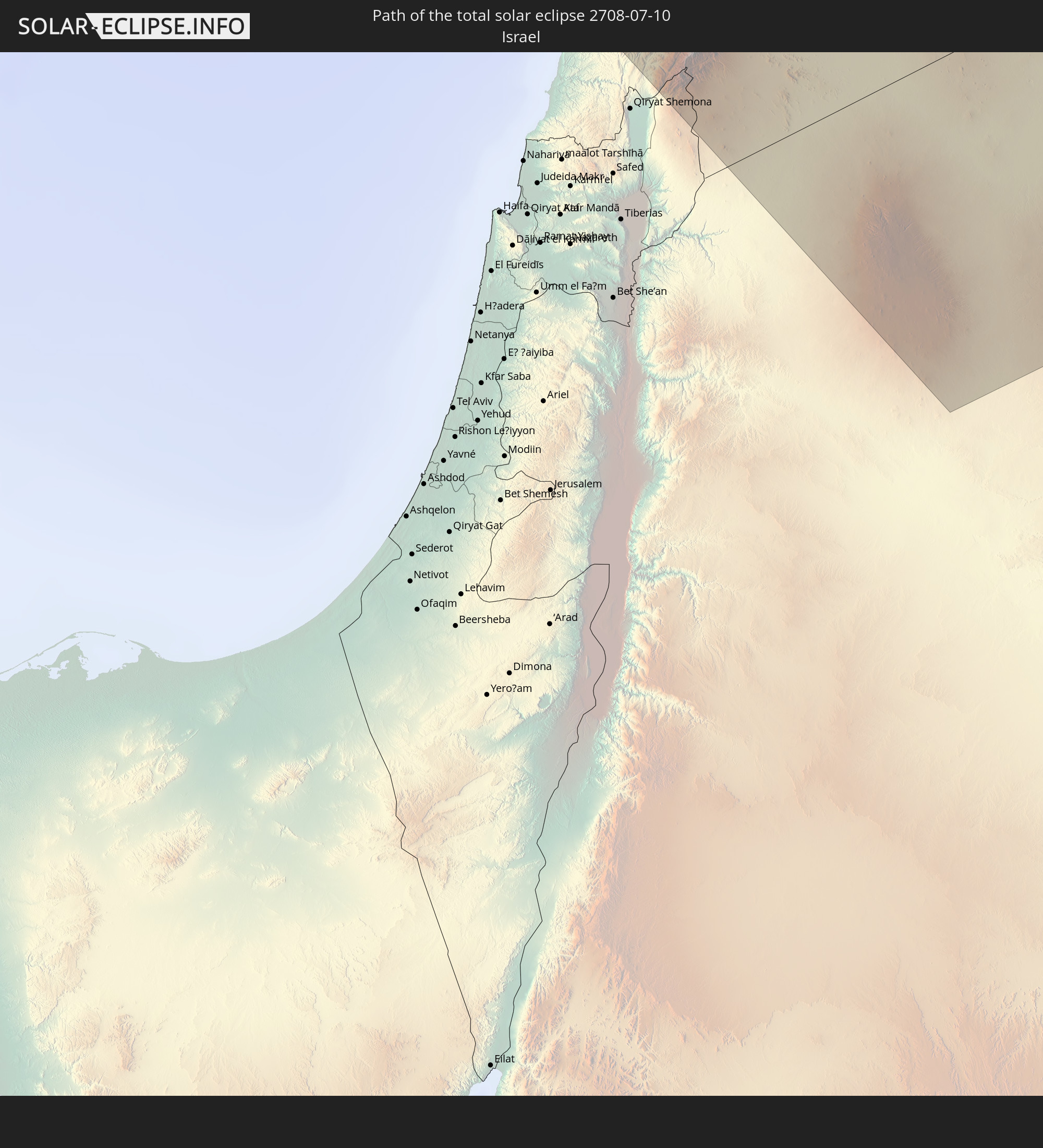 Israel
 Jordanien
 Libanon
 Syrien
 Irak
Irak
 Armenien
 Iran
Iran
 Aserbaidschan
 Kasachstan
 Turkmenistan
 Usbekistan
In den folgenden Ländern ist die Sonnenfinsternis partiell zu sehen
 Russland
 Vereinigte Staaten
 United States Minor Outlying Islands
 Kanada
 Grönland
 Island
 Spitzbergen
 Vereinigtes Königreich
 Färöer
 Norwegen
 Deutschland
 Dänemark
 Schweden
 Tschechien
 Polen
Polen
 Ungarn
 Slowakei
 Åland Islands
 Rumänien
 Finnland
 Litauen
 Lettland
 Estland
 Ukraine
 Bulgarien
 Weißrussland
 Türkei
 Moldawien
 Republik Zypern
 Israel
 Saudi-Arabien
 Jordanien
 Libanon
 Syrien
 Irak
Irak
 Georgien
 Jemen
Jemen
 Armenien
 Iran
Iran
 Aserbaidschan
 Kasachstan
 Kuwait
 Bahrain
 Katar
Katar
 Vereinigte Arabische Emirate
 Oman
Oman
 Turkmenistan
 Usbekistan
 Afghanistan
 Pakistan
 Tadschikistan
 Indien
 Kirgisistan
 Volksrepublik China
 Nepal
Nepal
 Mongolei
 Bangladesch
 Bhutan
 Myanmar
 Laos
Laos
 Vietnam
 Taiwan
 Japan
Japan
 Nordkorea
 Südkorea
 Nördliche Marianen
 Marshallinseln
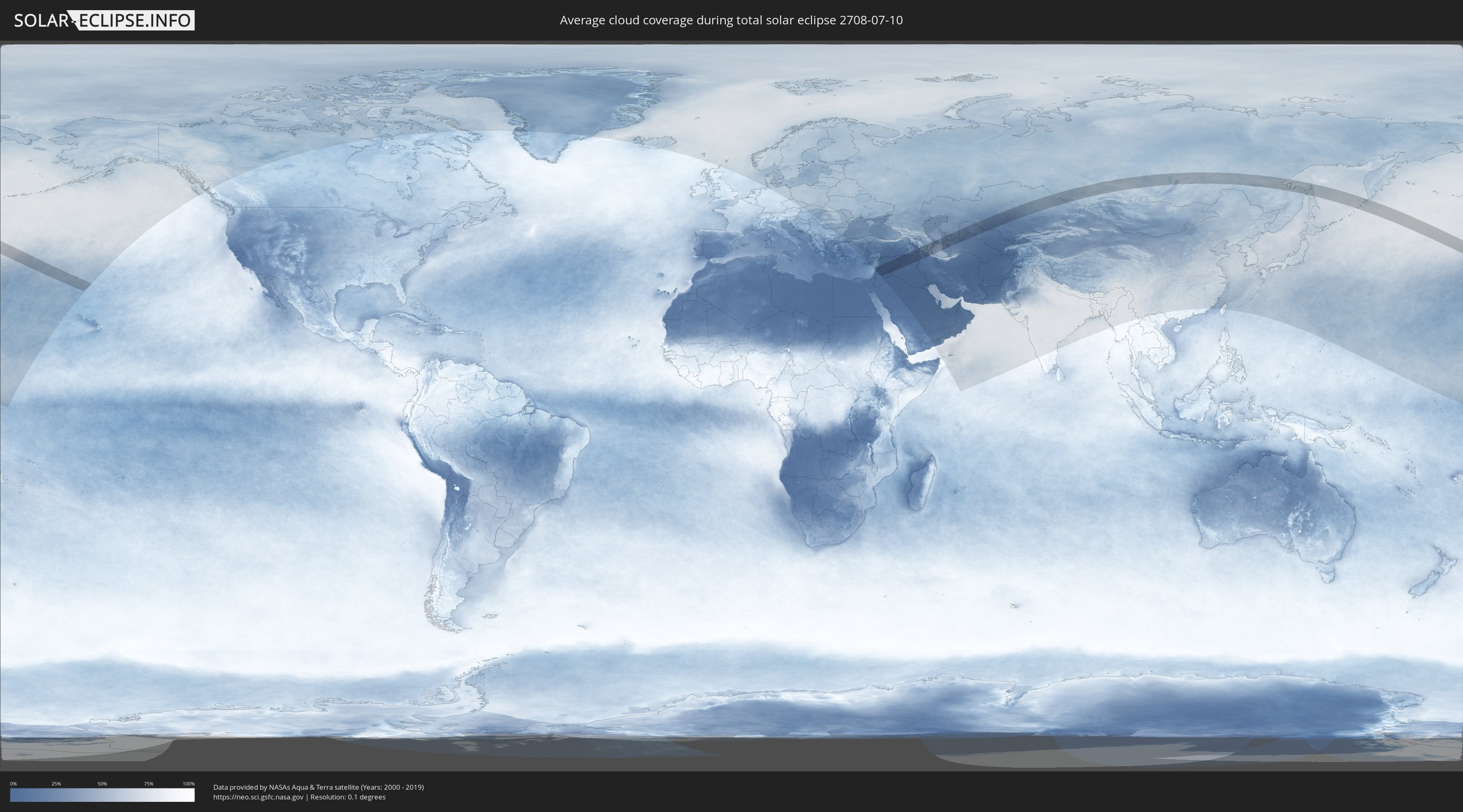
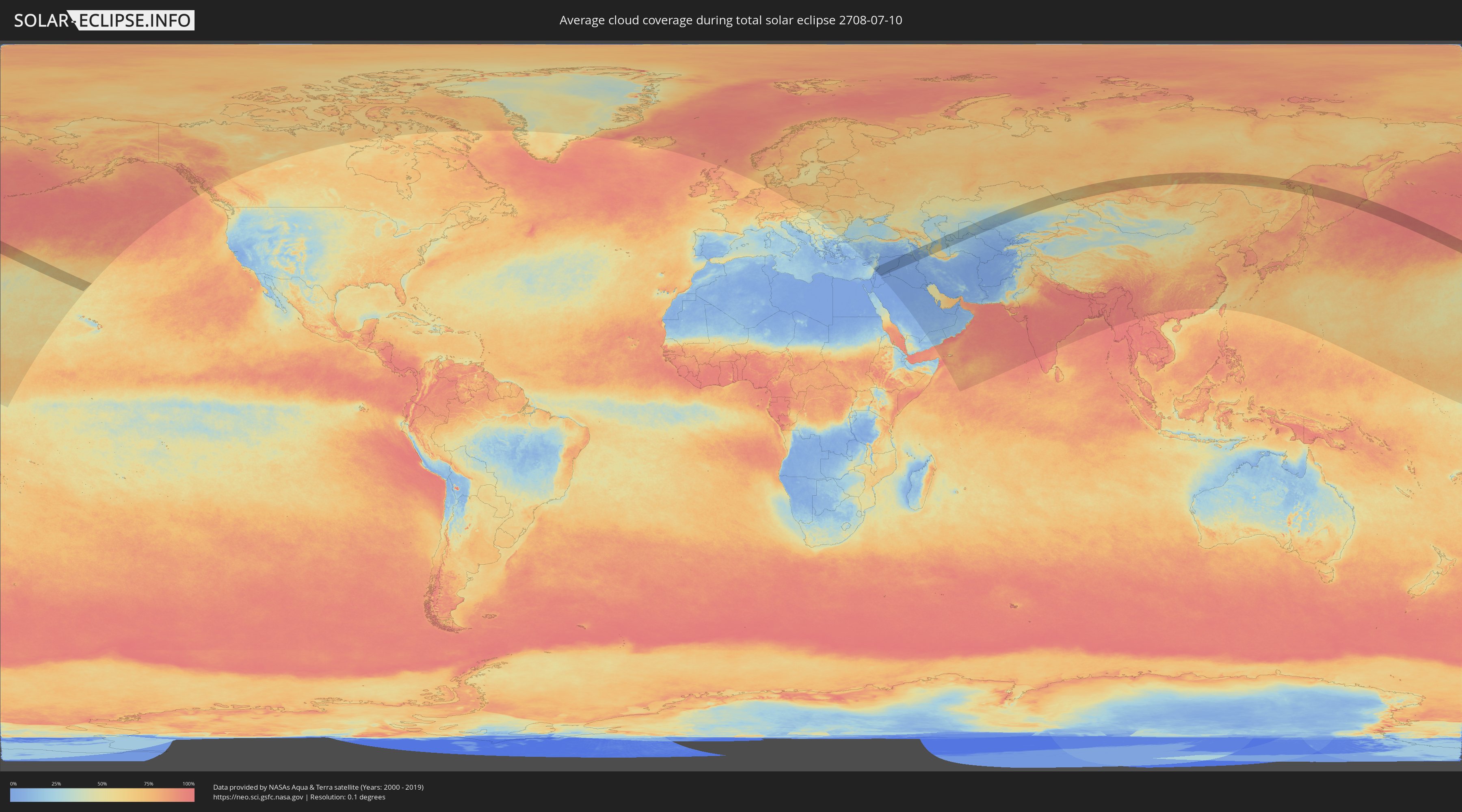
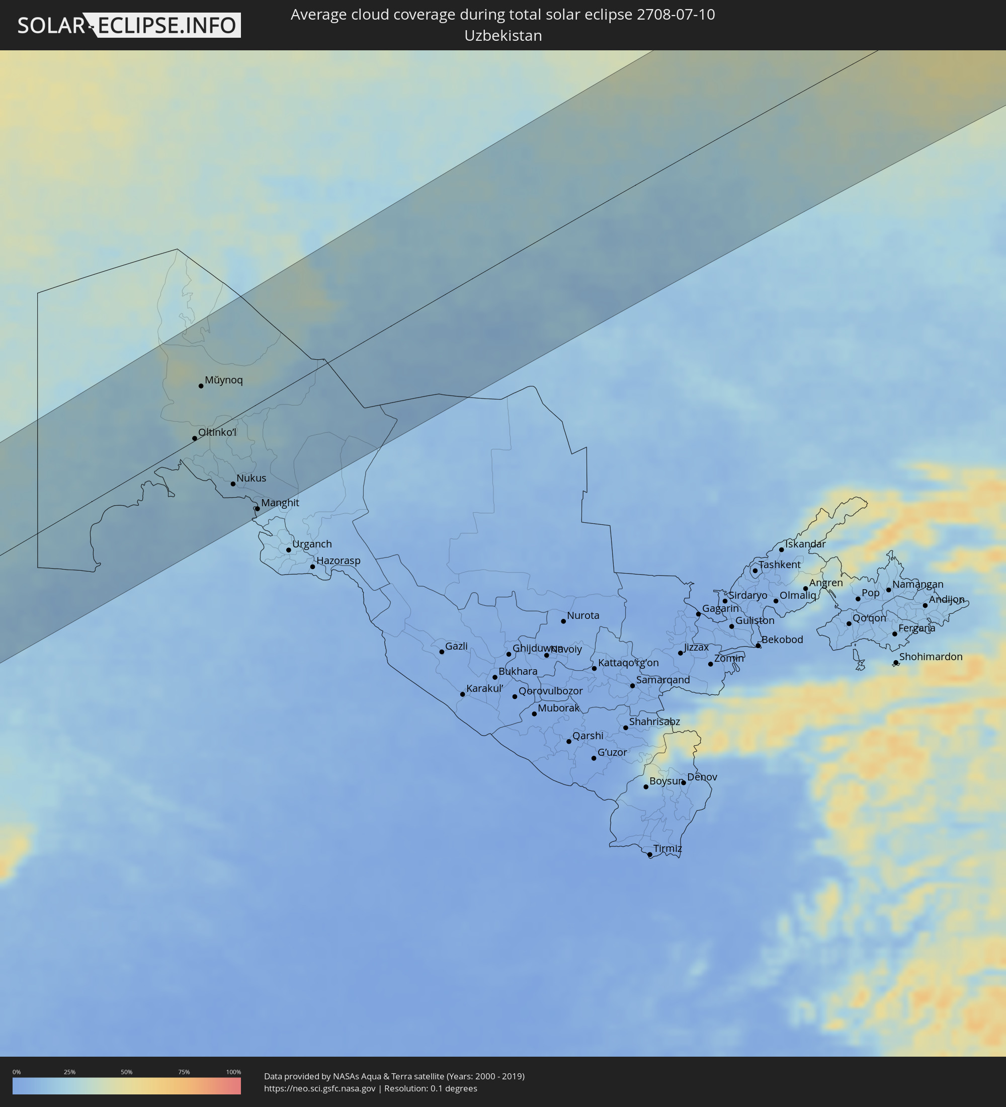
Wie wird das Wetter während der totalen Sonnenfinsternis am 10.07.2708?
Wo ist der beste Ort, um die totale Sonnenfinsternis vom 10.07.2708 zu beobachten?
Die folgenden Karten zeigen die durchschnittliche Bewölkung für den Tag, an dem die totale Sonnenfinsternis
stattfindet. Mit Hilfe der Karten lässt sich der Ort entlang des Finsternispfades eingrenzen,
der die besten Aussichen auf einen klaren wolkenfreien Himmel bietet.
Trotzdem muss man immer lokale Gegenenheiten beachten und sollte sich genau über das Wetter an seinem
gewählten Beobachtungsort informieren.
Die Daten stammen von den beiden NASA-Satelliten
AQUA und TERRA
und wurden über einen Zeitraum von 19 Jahren (2000 - 2019) gemittelt.
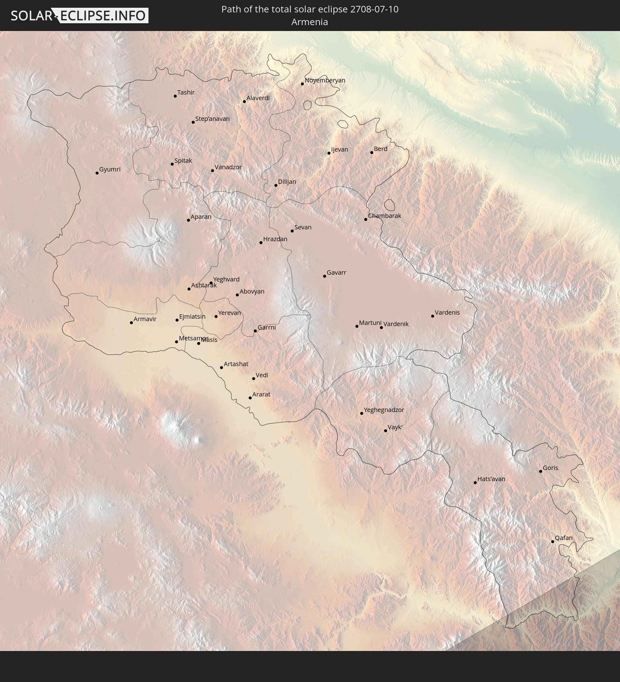
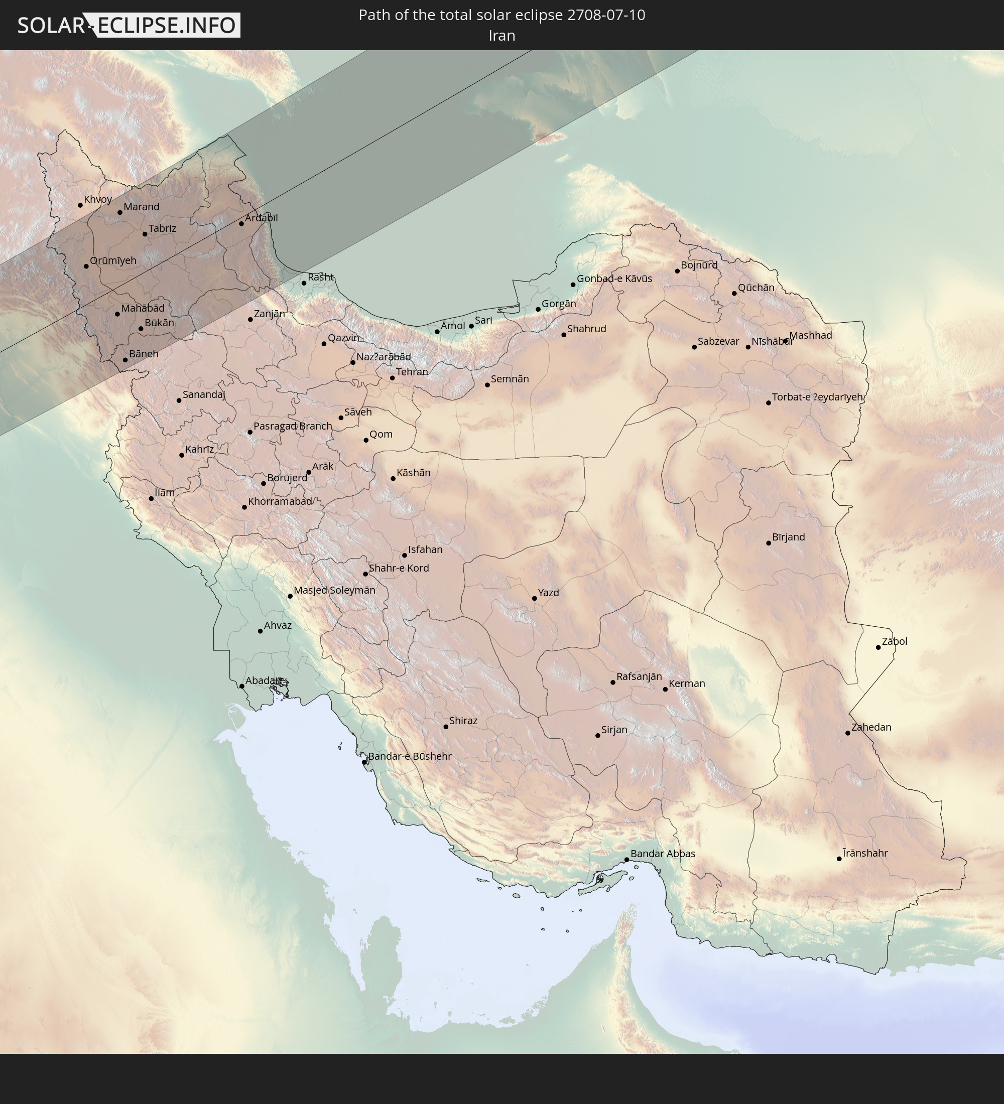
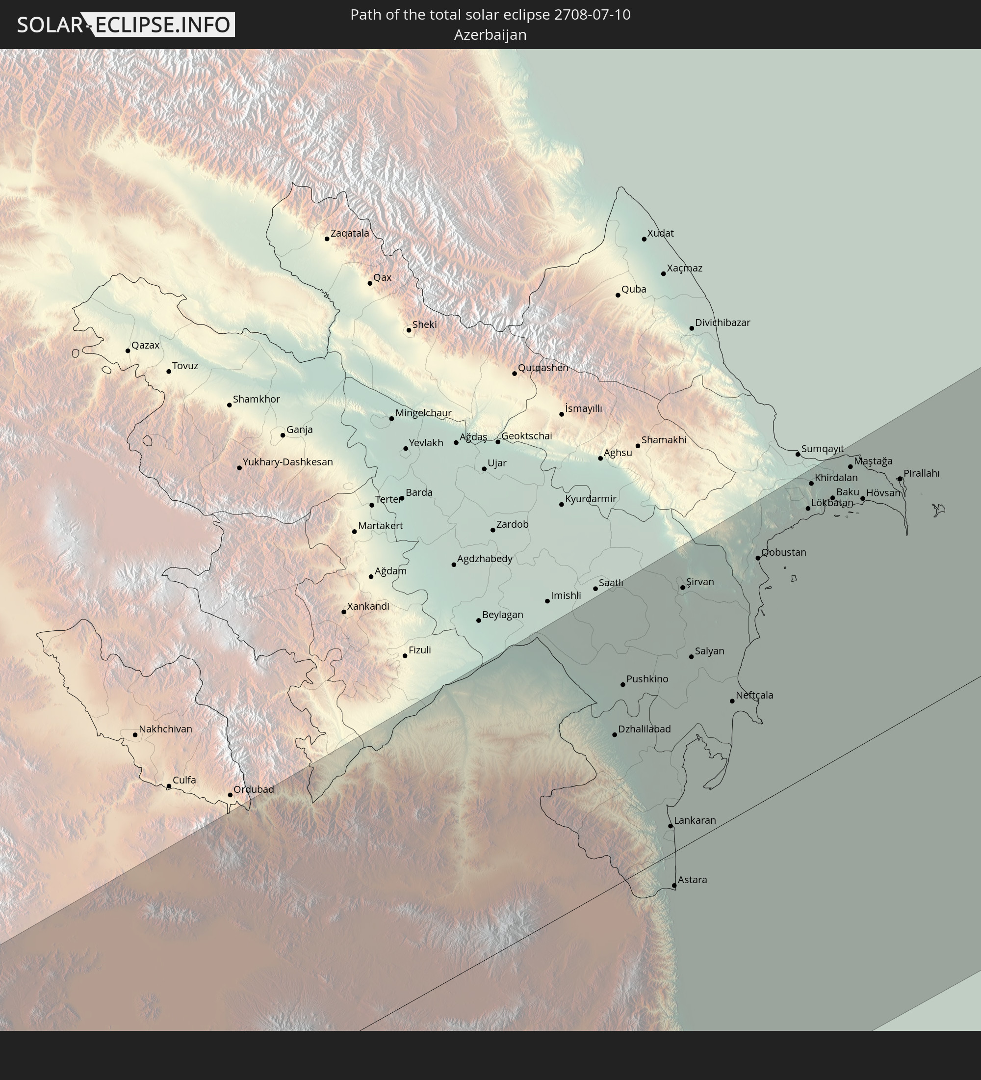
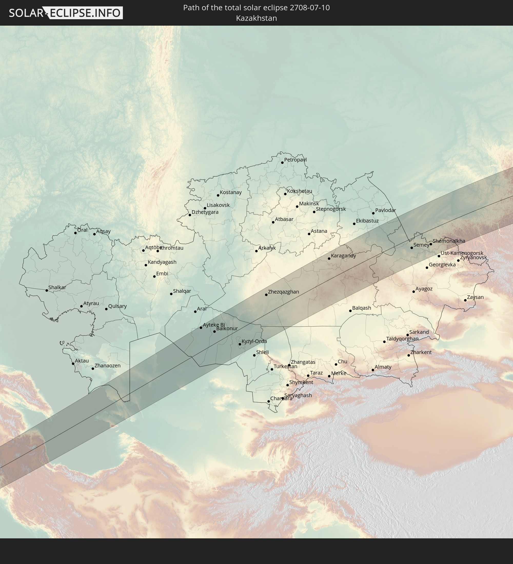
Detaillierte Länderkarten
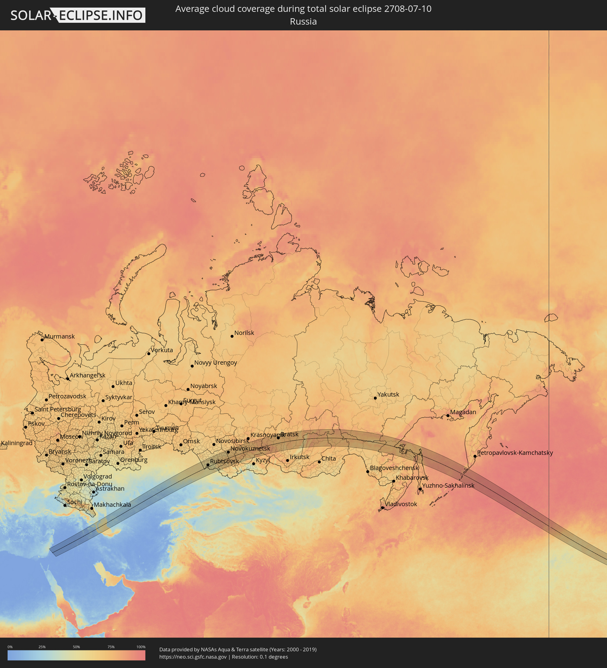 Russland
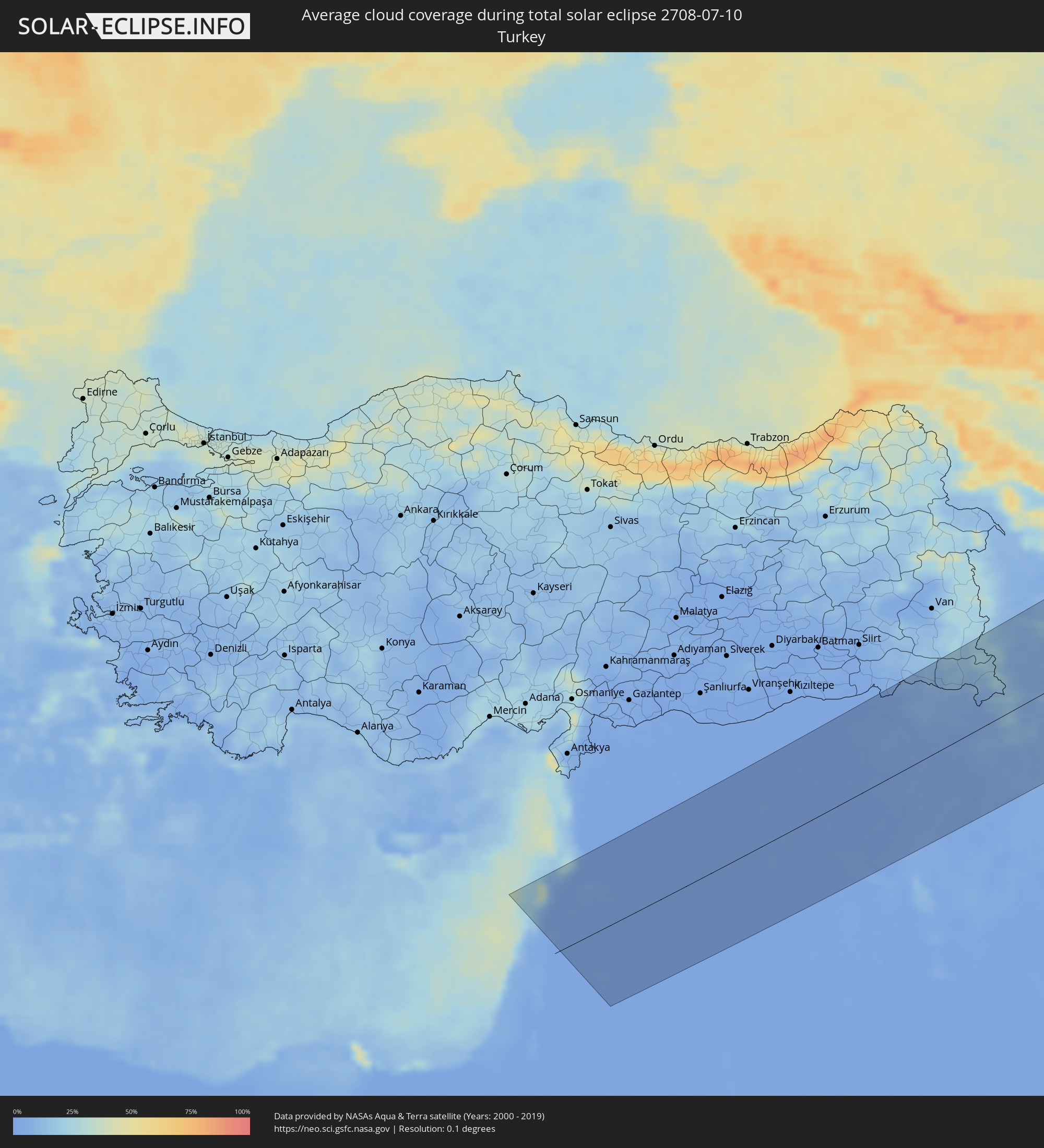 Türkei
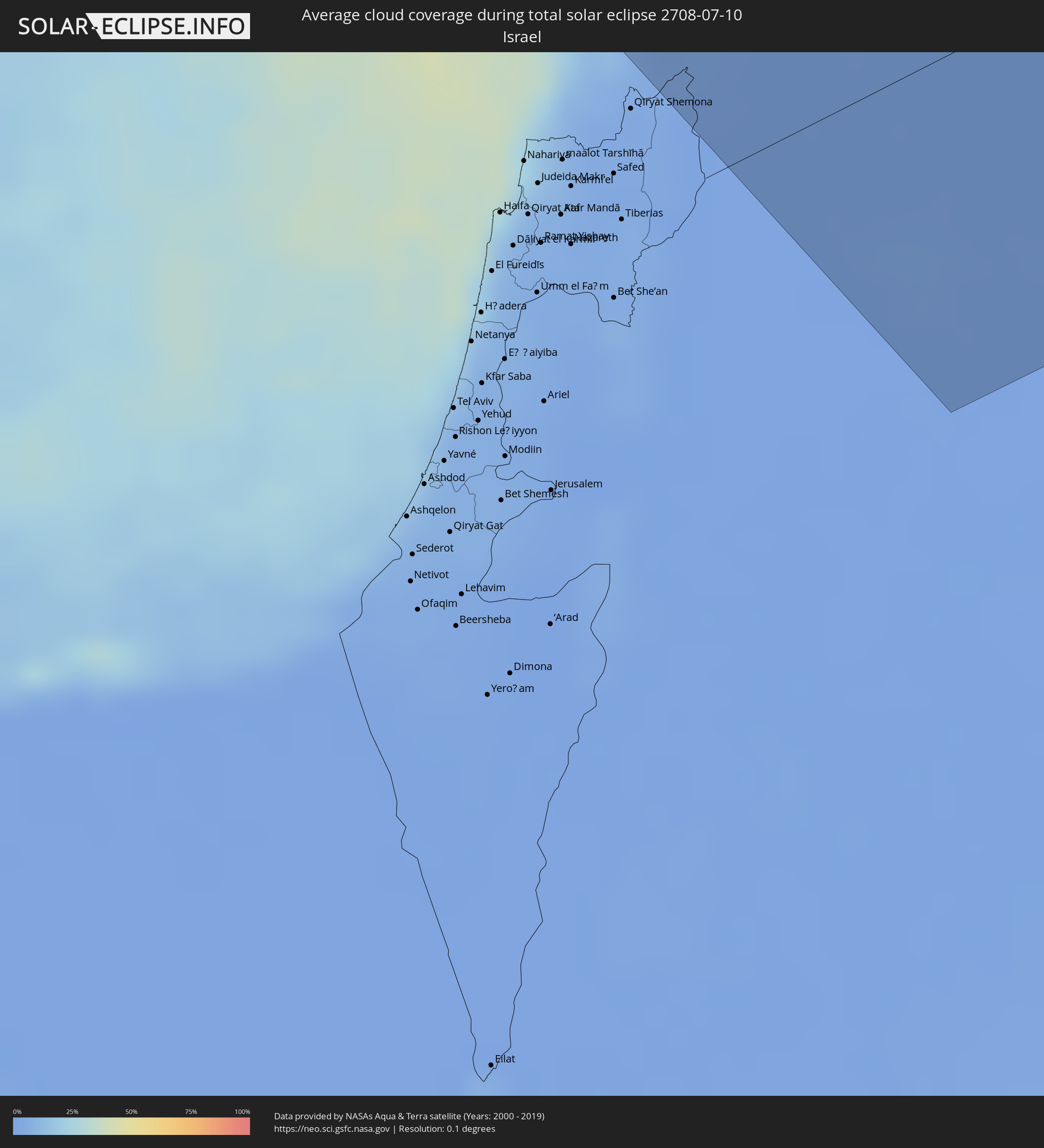 Israel
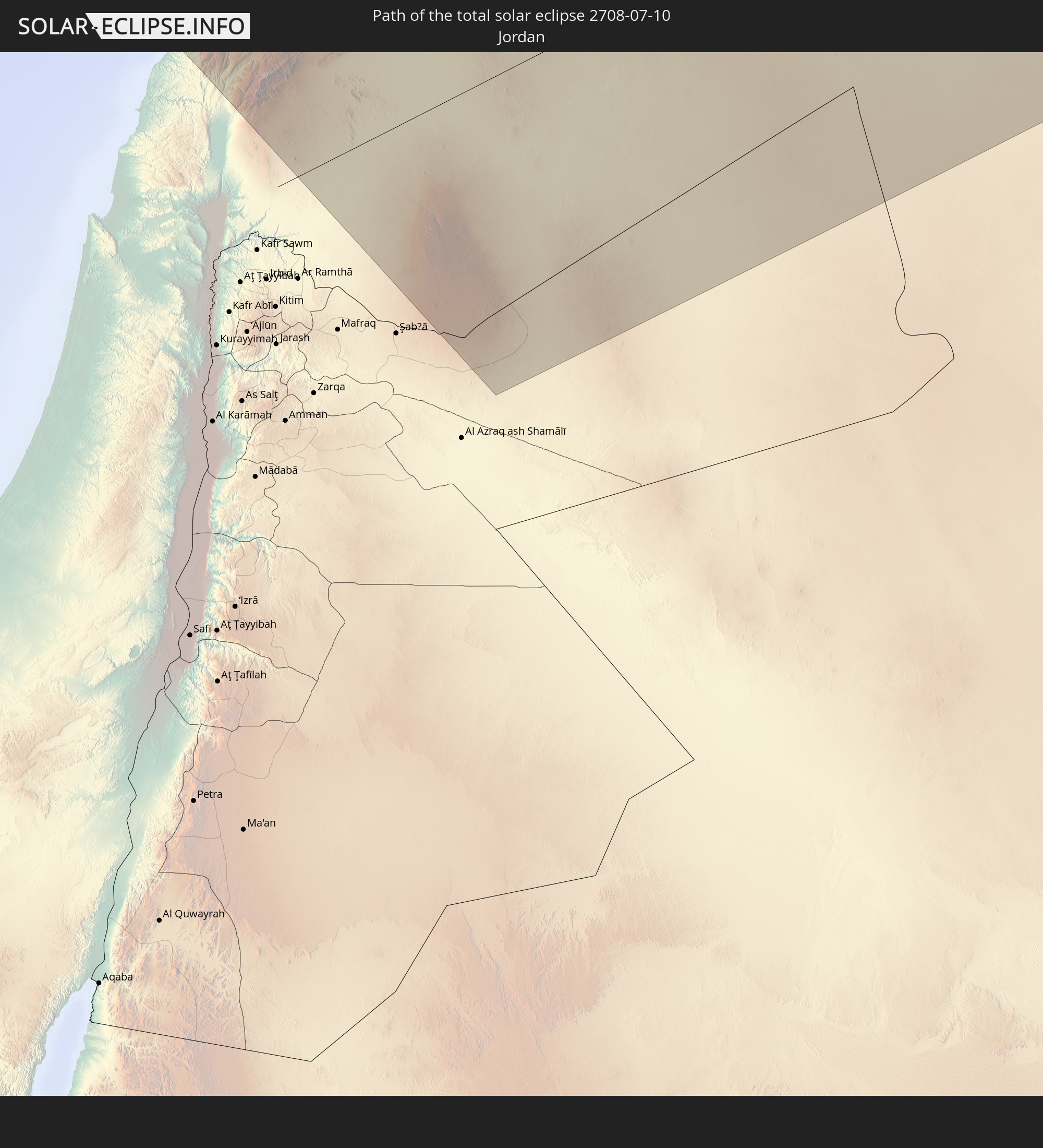
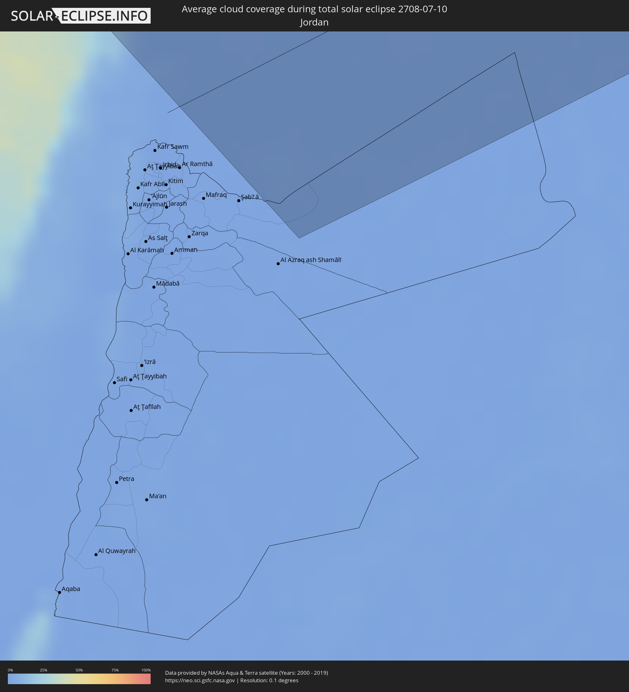 Jordanien
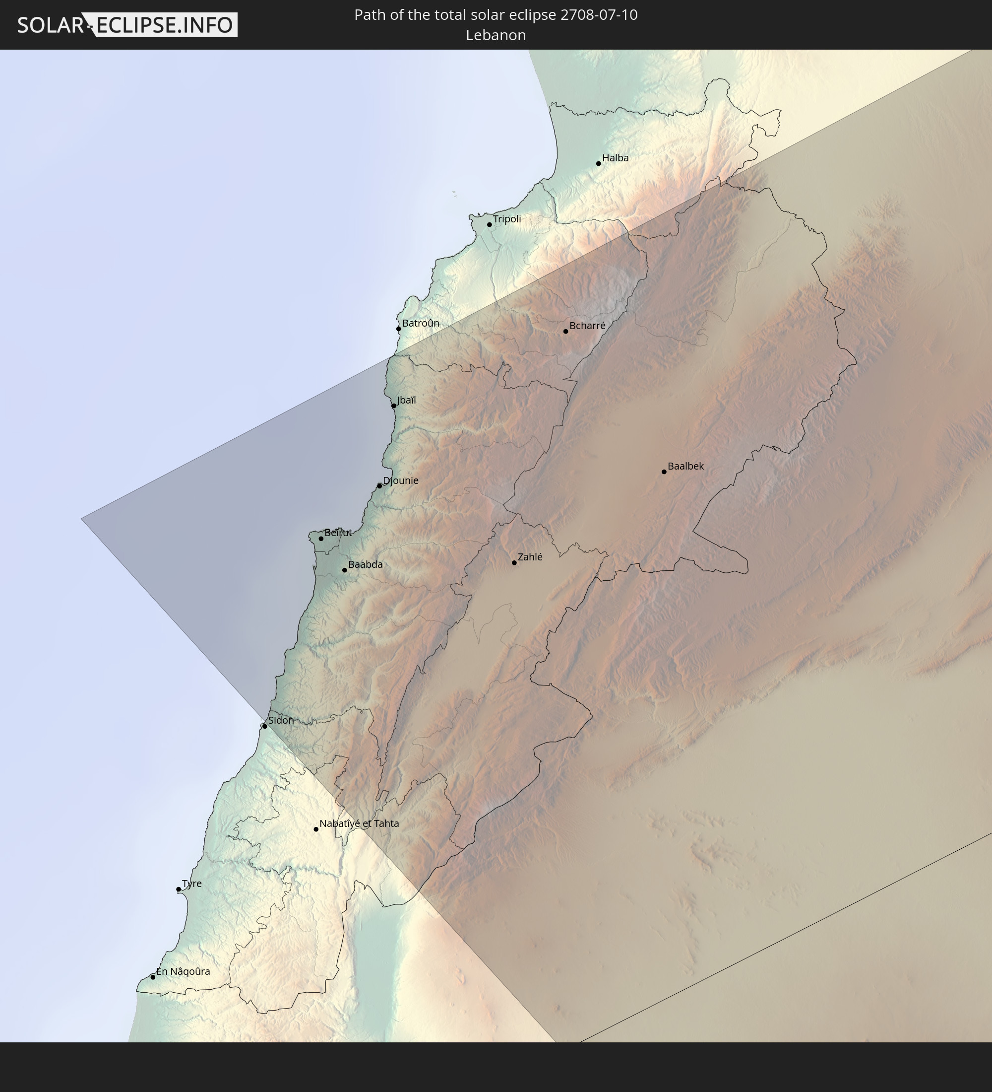
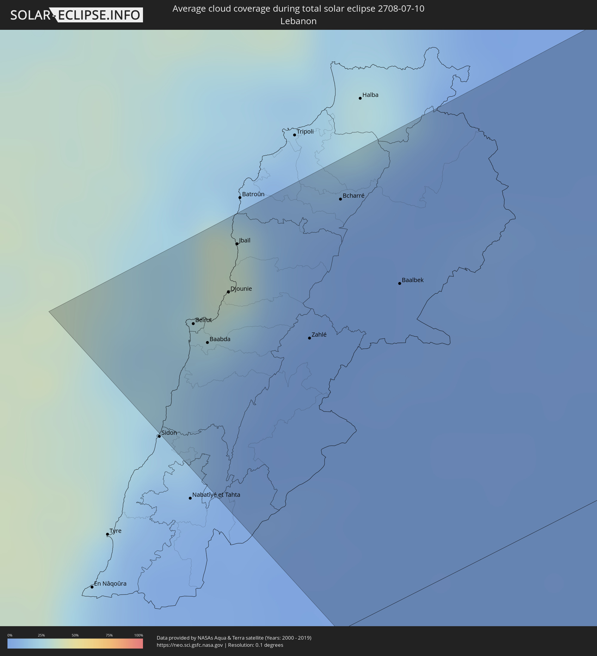 Libanon
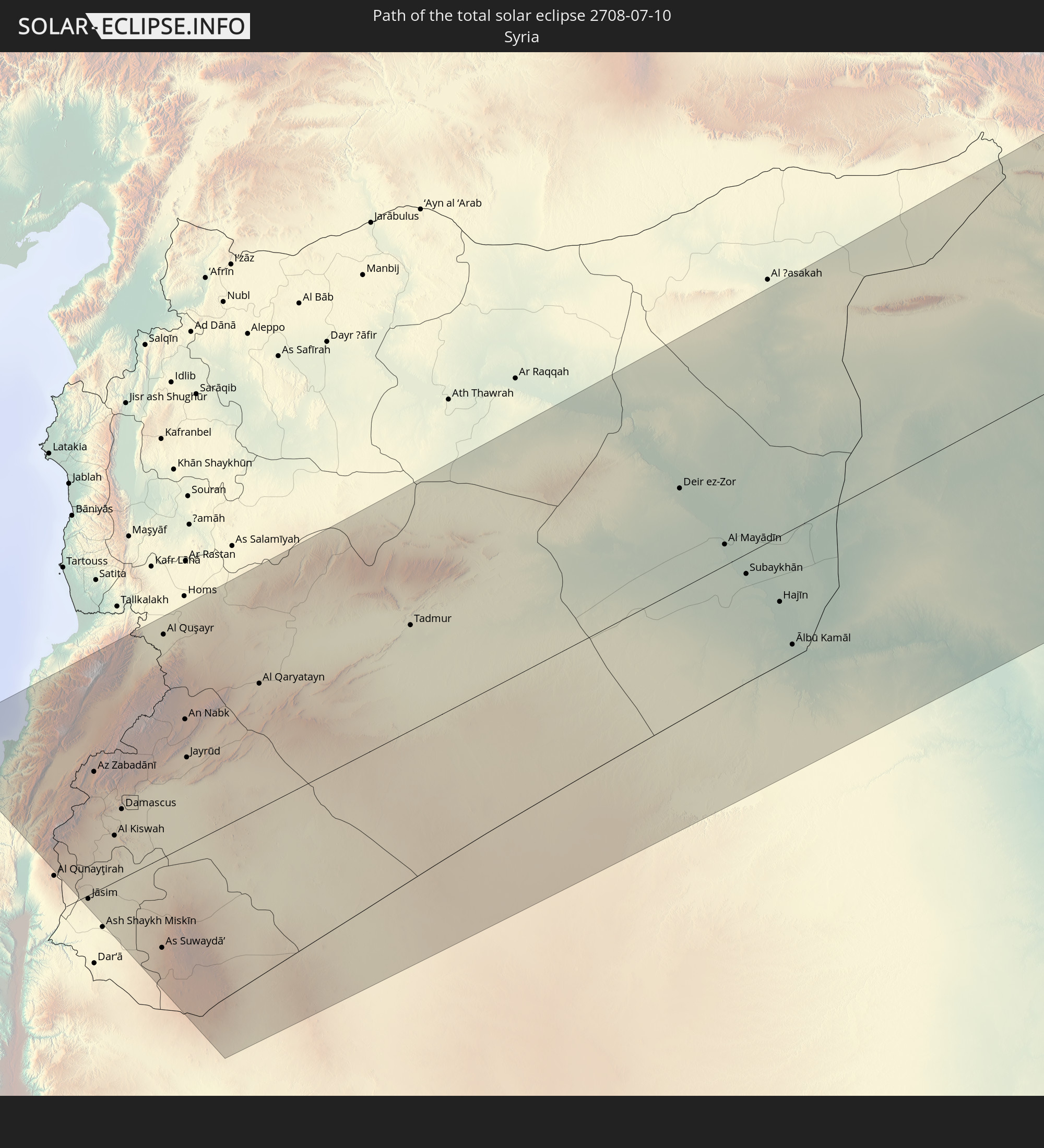
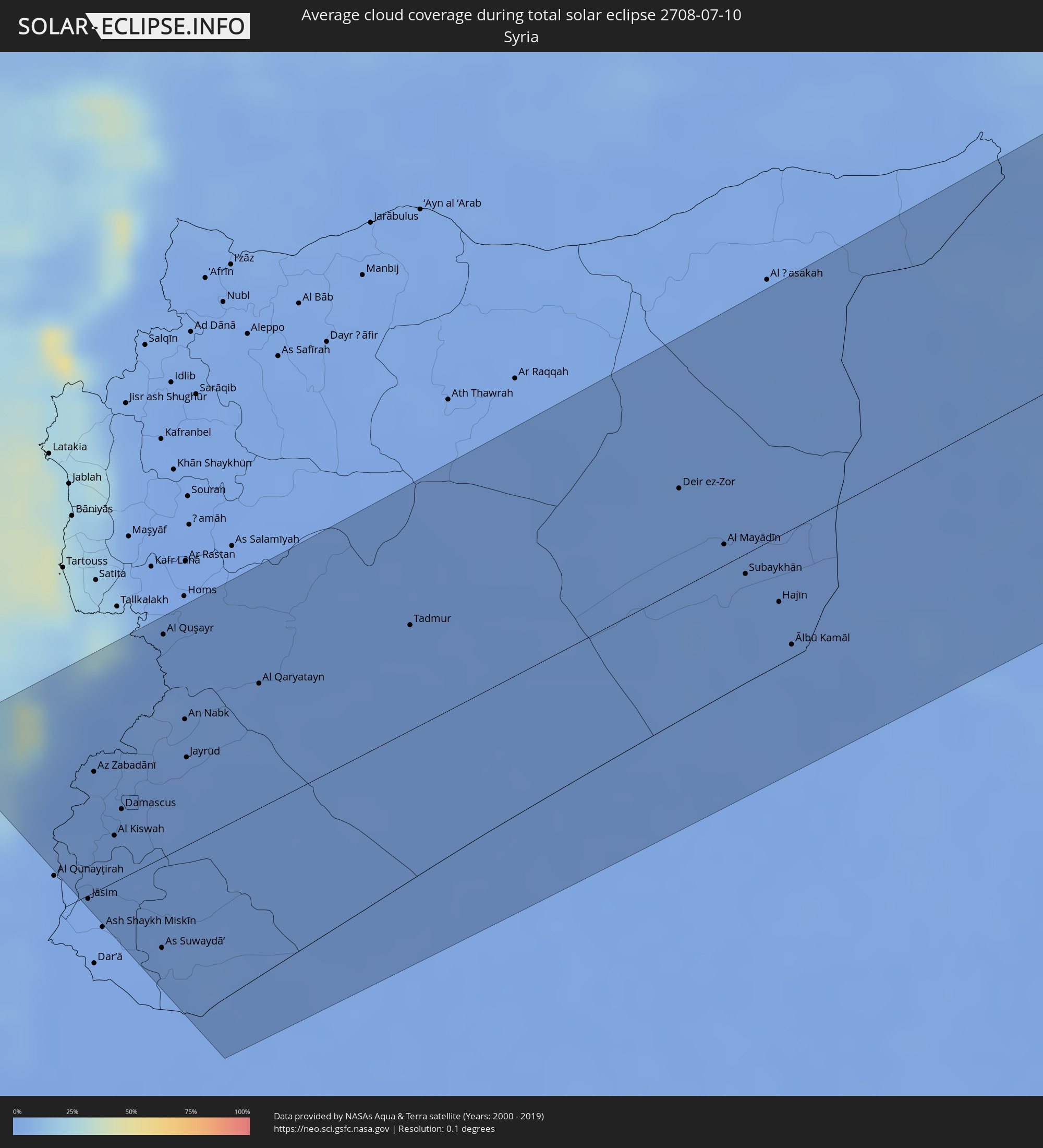 Syrien
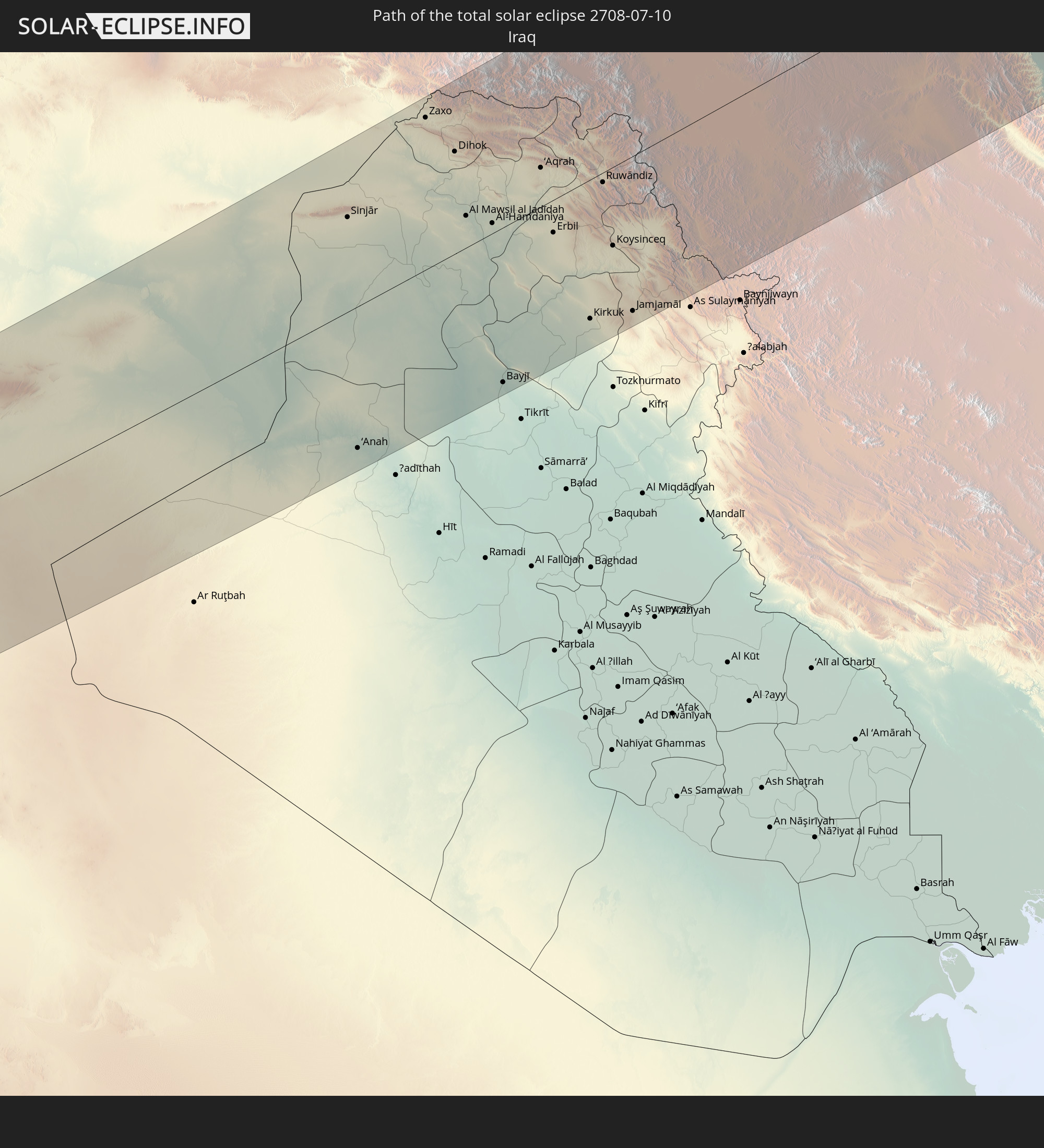
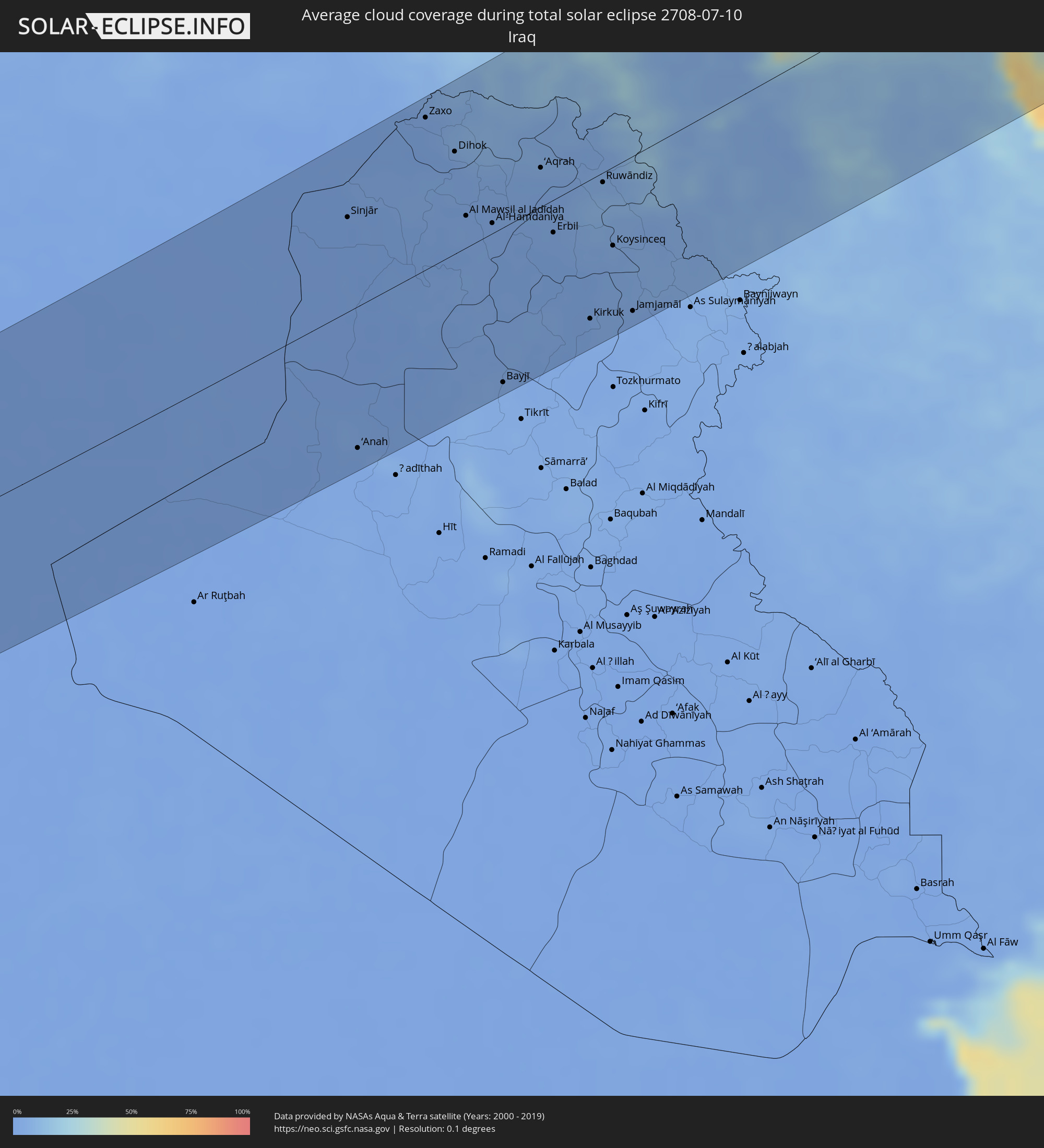 Irak
Irak
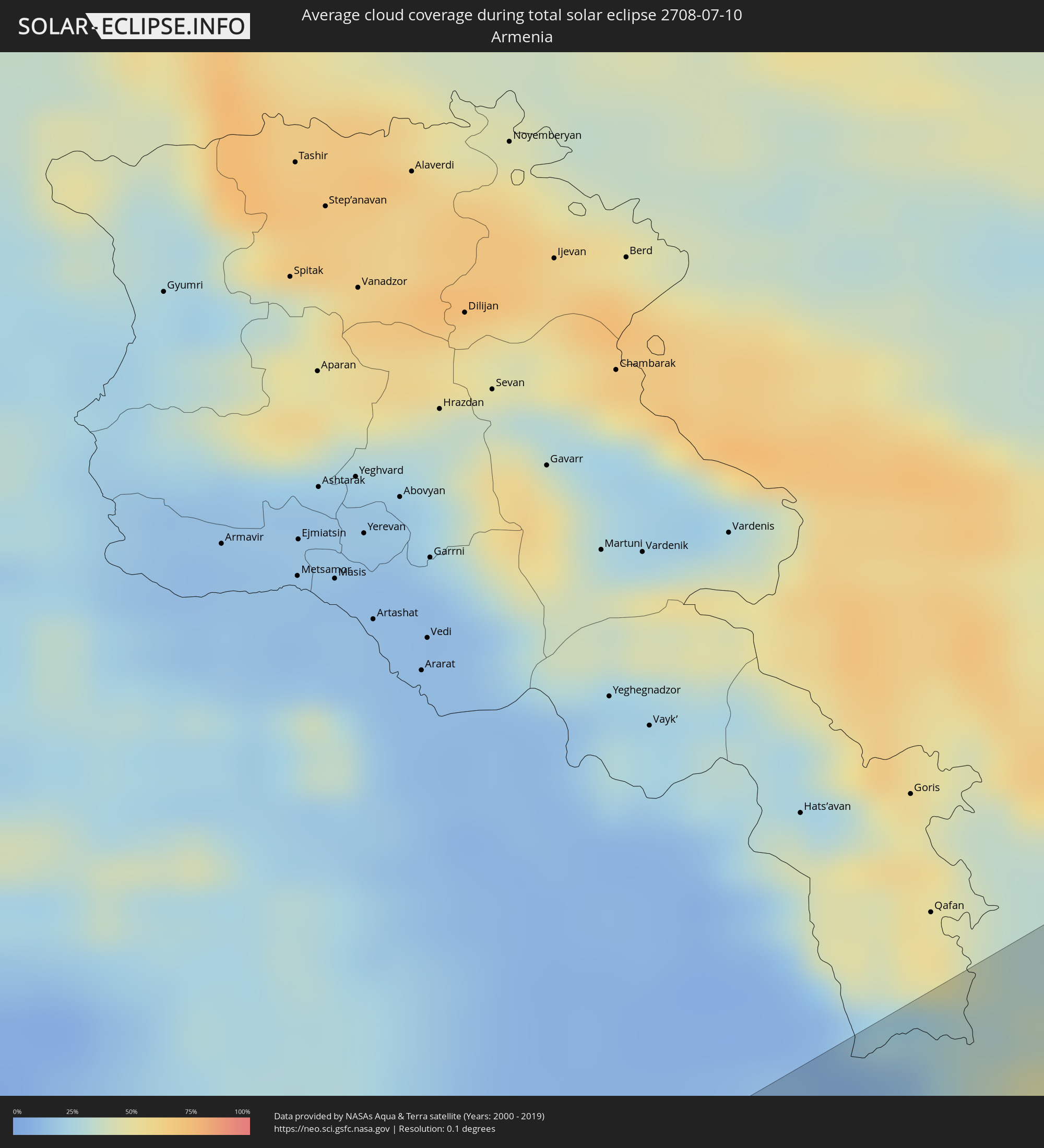 Armenien
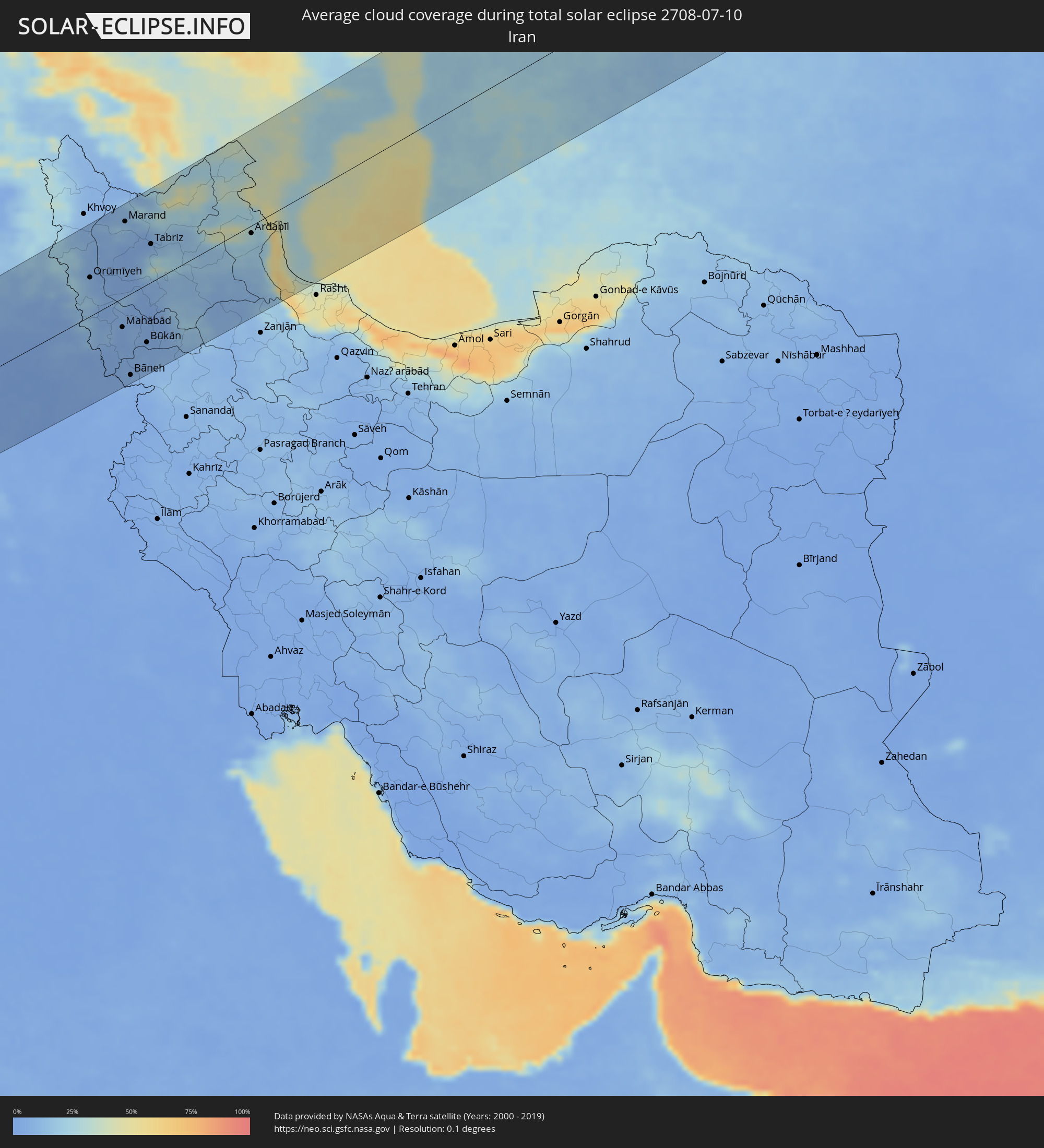 Iran
Iran
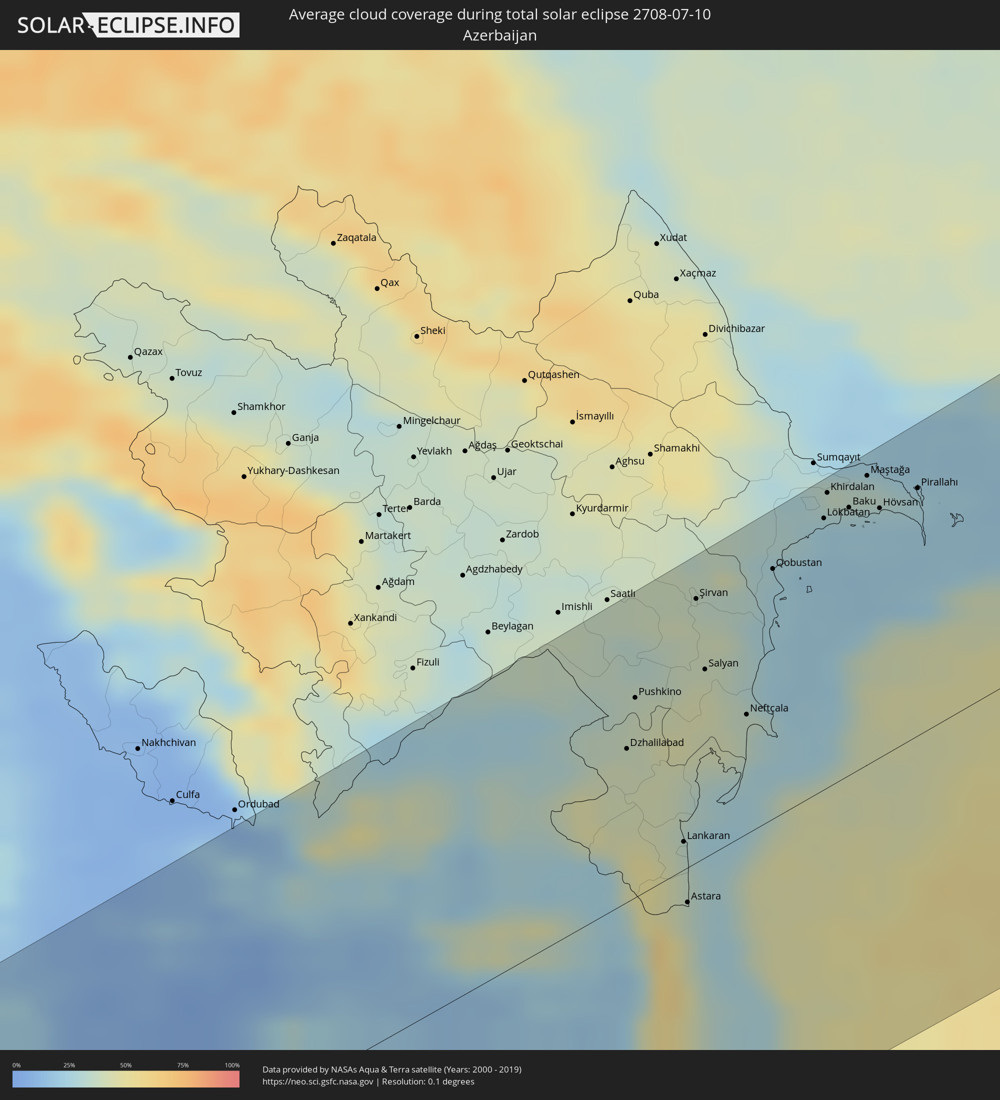 Aserbaidschan
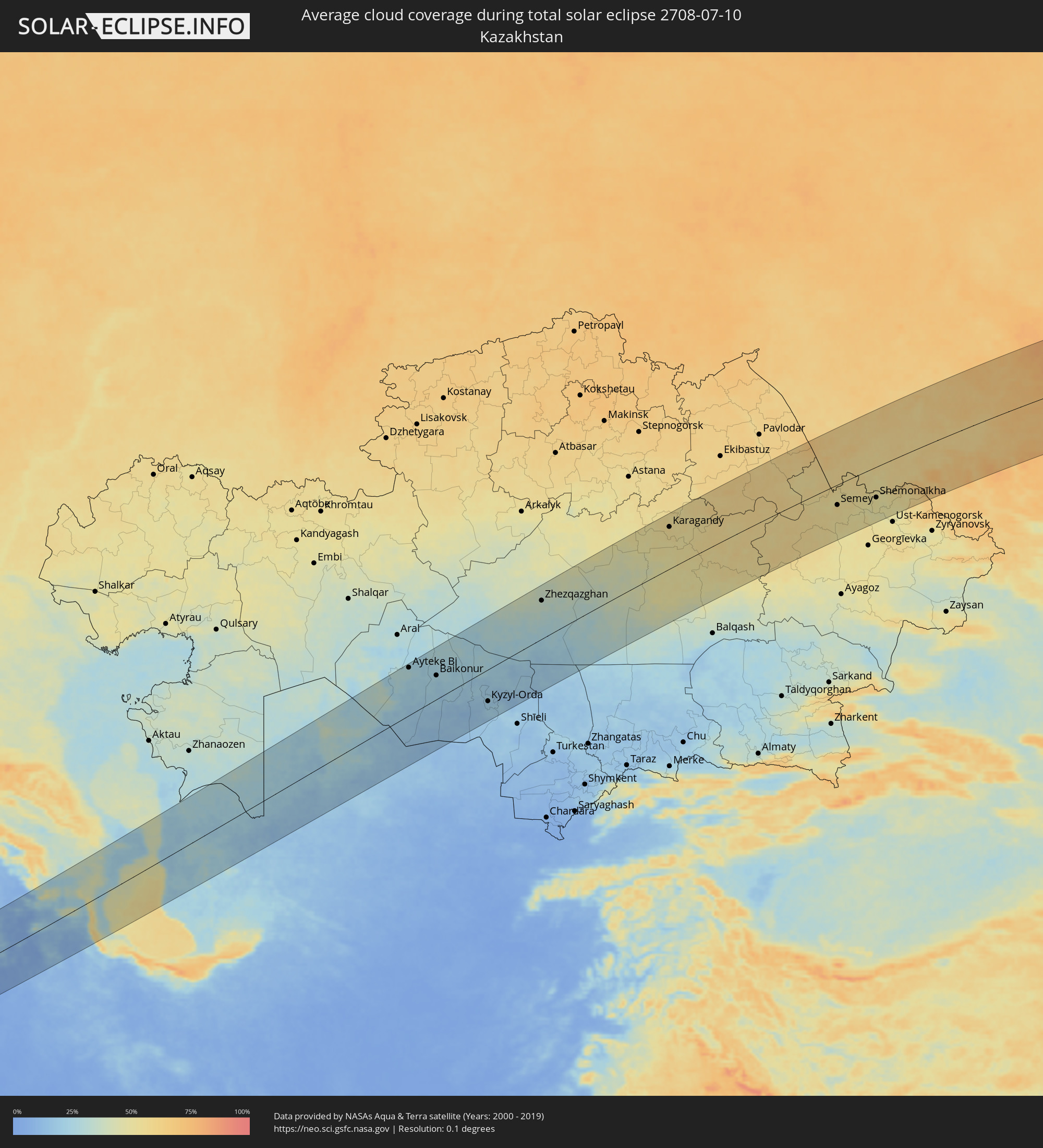 Kasachstan
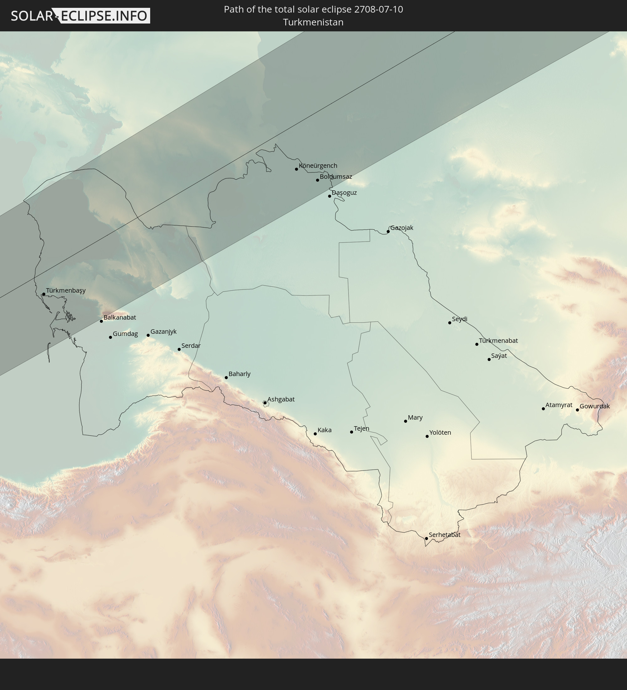
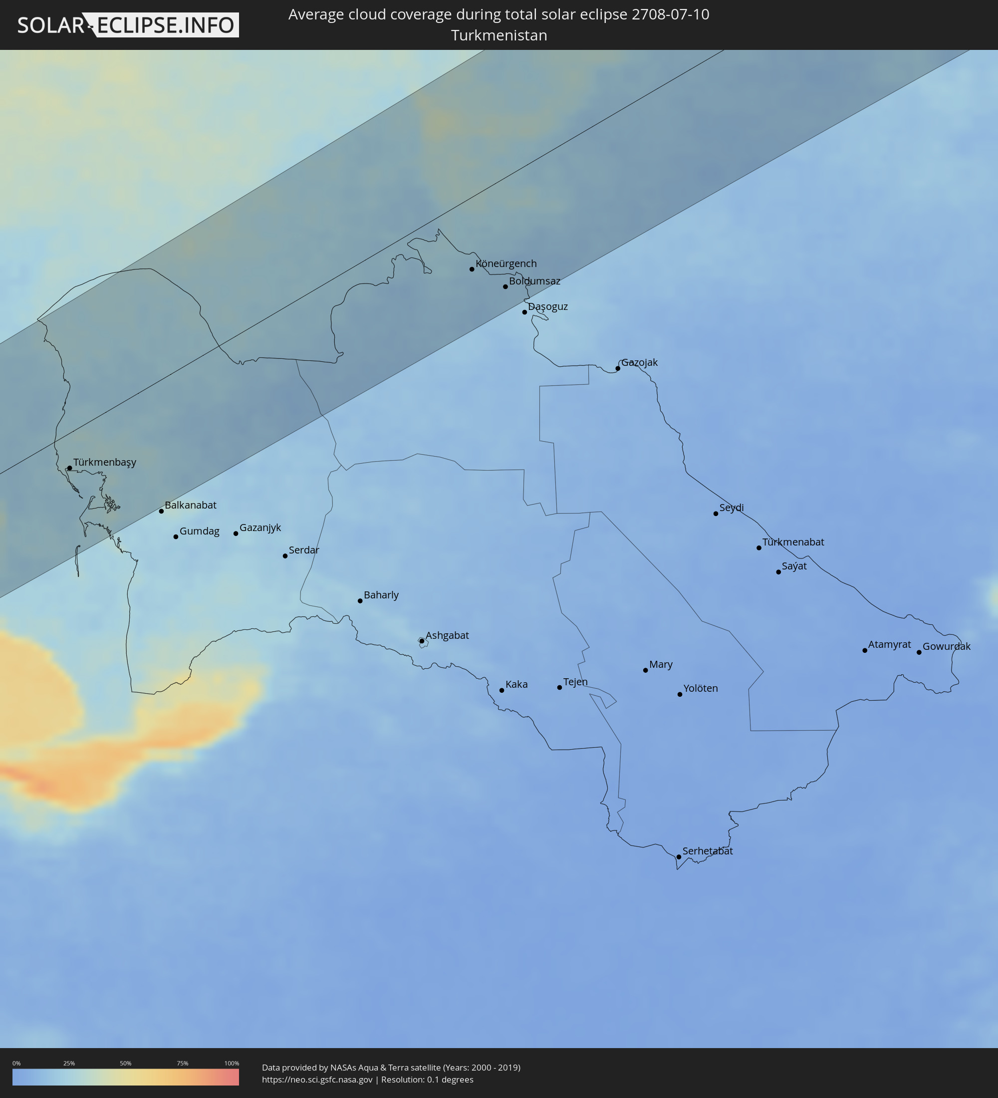 Turkmenistan
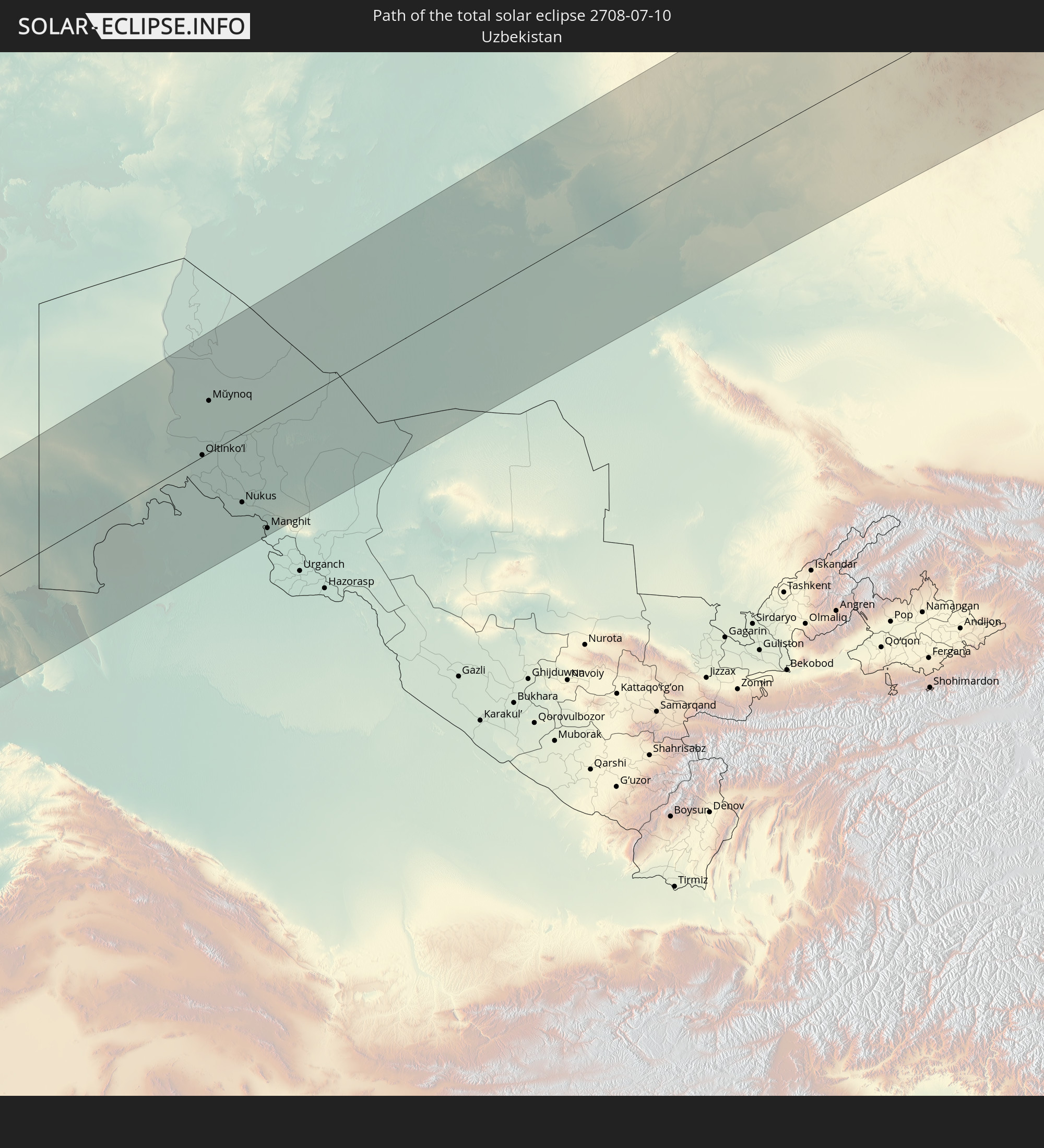
 Usbekistan
Orte im Finsternispfad
Die nachfolgene Tabelle zeigt Städte und Orte mit mehr als 5.000 Einwohnern, die sich im Finsternispfad befinden. Städte mit mehr als 100.000 Einwohnern sind dick gekennzeichnet. Mit einem Klick auf den Ort öffnet sich eine Detailkarte die die Lage des jeweiligen Ortes zusammen mit dem Verlauf der zentralen Finsternis präsentiert.
| Ort | Typ | Dauer der Verfinsterung | Ortszeit bei maximaler Verfinsterung | Entfernung zur Zentrallinie | Ø Bewölkung |
|
Ra’s Bayrūt, Beyrouth
|
total | - | 04:43:23 UTC+02:00 | 112 km | 20% |
|
Beirut, Beyrouth
|
total | - | 04:43:22 UTC+02:00 | 111 km | 20% |
|
Baabda, Mont-Liban
|
total | - | 04:43:18 UTC+02:00 | 103 km | 17% |
|
Djounie, Mont-Liban
|
total | - | 04:43:25 UTC+02:00 | 116 km | 30% |
|
Jbaïl, Mont-Liban
|
total | - | 04:43:32 UTC+02:00 | 129 km | 35% |
|
Zahlé, Béqaa
|
total | - | 04:43:10 UTC+02:00 | 91 km | 1% |
|
Bcharré, Liban-Nord
|
total | - | 04:43:31 UTC+02:00 | 125 km | 7% |
|
Jāsim, Daraa
|
total | - | 04:42:17 UTC+02:00 | 6 km | 0% |
|
Az Zabadānī, Rif-dimashq
|
total | - | 04:42:58 UTC+02:00 | 69 km | 1% |
|
Inkhil, Daraa
|
total | - | 04:42:17 UTC+02:00 | 12 km | 0% |
|
Aş Şanamayn, Daraa
|
total | - | 04:42:19 UTC+02:00 | 19 km | 0% |
|
Baalbek, Baalbek-Hermel
|
total | - | 04:43:12 UTC+02:00 | 93 km | 0% |
|
Al Kiswah, Rif-dimashq
|
total | - | 04:42:34 UTC+02:00 | 30 km | 0% |
|
Damascus, Dimashq
|
total | - | 04:42:41 UTC+02:00 | 40 km | 0% |
|
Al Ḩarāk, Daraa
|
total | - | 04:41:57 UTC+02:00 | 39 km | 0% |
|
Ḩarastā, Rif-dimashq
|
total | - | 04:42:43 UTC+02:00 | 42 km | 1% |
|
As Suwaydā’, As-Suwayda
|
total | - | 04:41:49 UTC+02:00 | 55 km | 1% |
|
Al Quşayr, Homs
|
total | - | 04:43:34 UTC+02:00 | 128 km | 0% |
|
Yabrūd, Rif-dimashq
|
total | - | 04:43:00 UTC+02:00 | 69 km | 1% |
|
An Nabk, Rif-dimashq
|
total | - | 04:43:02 UTC+02:00 | 73 km | 1% |
|
Jayrūd, Rif-dimashq
|
total | - | 04:42:48 UTC+02:00 | 50 km | 1% |
|
Al Qaryatayn, Homs
|
total | - | 04:43:02 UTC+02:00 | 71 km | 0% |
|
Tadmur, Homs
|
total | - | 04:43:00 UTC+02:00 | 60 km | 0% |
|
Deir ez-Zor, Deir ez-Zor
|
total | - | 04:43:12 UTC+02:00 | 56 km | 1% |
|
Al Mayādīn, Deir ez-Zor
|
total | - | 04:42:47 UTC+02:00 | 12 km | 1% |
|
Subaykhān, Deir ez-Zor
|
total | - | 04:42:34 UTC+02:00 | 12 km | 2% |
|
Hajīn, Deir ez-Zor
|
total | - | 04:42:19 UTC+02:00 | 40 km | 1% |
|
Ālbū Kamāl, Deir ez-Zor
|
total | - | 04:42:03 UTC+02:00 | 65 km | 1% |
|
Sinjār, Nīnawá
|
total | - | 05:43:46 UTC+03:00 | 81 km | 0% |
|
Rāwah, Anbar
|
total | - | 05:41:47 UTC+03:00 | 105 km | 2% |
|
‘Anat al Qadīmah, Anbar
|
total | - | 05:41:46 UTC+03:00 | 107 km | 2% |
|
‘Anah, Anbar
|
total | - | 05:41:39 UTC+03:00 | 119 km | 2% |
|
Zaxo, Dahūk
|
total | - | 05:44:29 UTC+03:00 | 125 km | 2% |
|
Dihok, Dahūk
|
total | - | 05:44:06 UTC+03:00 | 84 km | 3% |
|
Sīnah, Dahūk
|
total | - | 05:44:02 UTC+03:00 | 76 km | 3% |
|
Al Mawşil al Jadīdah, Nīnawá
|
total | - | 05:43:29 UTC+03:00 | 36 km | 3% |
|
Mosul, Nīnawá
|
total | - | 05:43:29 UTC+03:00 | 36 km | 3% |
|
Tallkayf, Nīnawá
|
total | - | 05:43:39 UTC+03:00 | 44 km | 2% |
|
Al-Hamdaniya, Nīnawá
|
total | - | 05:43:21 UTC+03:00 | 12 km | 2% |
|
Bayjī, Salah ad Din Governorate
|
total | - | 05:41:52 UTC+03:00 | 129 km | 4% |
|
Çukurca, Hakkâri
|
total | - | 05:44:24 UTC+03:00 | 94 km | 7% |
|
Hakkari, Hakkâri
|
total | - | 05:44:44 UTC+03:00 | 120 km | 11% |
|
‘Aqrah, Nīnawá
|
total | - | 05:43:46 UTC+03:00 | 32 km | 3% |
|
Erbil, Arbīl
|
total | - | 05:43:08 UTC+03:00 | 30 km | 2% |
|
Yüksekova, Hakkâri
|
total | - | 05:44:38 UTC+03:00 | 98 km | 12% |
|
Kirkuk, At Taʼmīm
|
total | - | 05:42:15 UTC+03:00 | 116 km | 2% |
|
Ruwāndiz, Arbīl
|
total | - | 05:43:29 UTC+03:00 | 8 km | 7% |
|
Şemdinli, Hakkâri
|
total | - | 05:44:16 UTC+03:00 | 59 km | 9% |
|
Koysinceq, Arbīl
|
total | - | 05:42:52 UTC+03:00 | 68 km | 4% |
|
Salmās, Āz̄ārbāyjān-e Gharbī
|
total | - | 06:15:16 UTC+03:30 | 136 km | 12% |
|
Jamjamāl, As Sulaymānīyah
|
total | - | 05:42:13 UTC+03:00 | 128 km | 2% |
|
Orūmīyeh, Āz̄ārbāyjān-e Gharbī
|
total | - | 06:14:27 UTC+03:30 | 61 km | 8% |
|
Oshnavīyeh, Āz̄ārbāyjān-e Gharbī
|
total | - | 06:13:52 UTC+03:30 | 18 km | 12% |
|
Piranshahr, Āz̄ārbāyjān-e Gharbī
|
total | - | 06:13:28 UTC+03:30 | 26 km | 12% |
|
Naqadeh, Āz̄ārbāyjān-e Gharbī
|
total | - | 06:13:43 UTC+03:30 | 21 km | 7% |
|
Mahābād, Āz̄ārbāyjān-e Gharbī
|
total | - | 06:13:26 UTC+03:30 | 45 km | 6% |
|
Marand, East Azerbaijan
|
total | - | 06:15:22 UTC+03:30 | 115 km | 14% |
|
Bāneh, Kordestān
|
total | - | 06:12:32 UTC+03:30 | 128 km | 7% |
|
Bonāb, East Azerbaijan
|
total | - | 06:14:03 UTC+03:30 | 5 km | 5% |
|
Mīāndoāb, Āz̄ārbāyjān-e Gharbī
|
total | - | 06:13:36 UTC+03:30 | 43 km | 5% |
|
Būkān, Āz̄ārbāyjān-e Gharbī
|
total | - | 06:13:04 UTC+03:30 | 92 km | 6% |
|
Saqqez, Kordestān
|
total | - | 06:12:45 UTC+03:30 | 119 km | 7% |
|
Tabriz, East Azerbaijan
|
total | - | 06:14:52 UTC+03:30 | 60 km | 9% |
|
Ahar, East Azerbaijan
|
total | - | 06:15:14 UTC+03:30 | 64 km | 21% |
|
Takāb, Āz̄ārbāyjān-e Gharbī
|
total | - | 06:12:48 UTC+03:30 | 141 km | 11% |
|
Pārsābād, Ardabīl
|
total | - | 06:16:33 UTC+03:30 | 141 km | 36% |
|
Ardabīl, Ardabīl
|
total | - | 06:14:49 UTC+03:30 | 26 km | 23% |
|
Əhmədbəyli, Saatlı
|
total | - | 06:46:48 UTC+04:00 | 143 km | 37% |
|
Dzhalilabad, Jalilabad
|
total | - | 06:45:58 UTC+04:00 | 73 km | 40% |
|
Khalkhāl, Ardabīl
|
total | - | 06:14:02 UTC+03:30 | 83 km | 16% |
|
Pushkino, Bilǝsuvar
|
total | - | 06:46:16 UTC+04:00 | 95 km | 36% |
|
Prishibinskoye, Jalilabad
|
total | - | 06:45:51 UTC+04:00 | 60 km | 42% |
|
Masally, Masally
|
total | - | 06:45:44 UTC+04:00 | 49 km | 41% |
|
Lankaran, Lənkəran
|
total | - | 06:45:23 UTC+04:00 | 15 km | 30% |
|
Astara, Astara
|
total | - | 06:45:01 UTC+04:00 | 28 km | 35% |
|
Hashtpar, Gīlān
|
total | - | 06:14:13 UTC+03:30 | 82 km | 47% |
|
Şirvan, Shirvan
|
total | - | 06:46:50 UTC+04:00 | 125 km | 39% |
|
Salyan, Salyan
|
total | - | 06:46:24 UTC+04:00 | 89 km | 42% |
|
Neftçala, Neftçala
|
total | - | 06:46:06 UTC+04:00 | 57 km | 36% |
|
Qobustan, Baki
|
total | - | 06:46:58 UTC+04:00 | 117 km | 28% |
|
Bandar-e Anzalī, Gīlān
|
total | - | 06:13:47 UTC+03:30 | 138 km | 36% |
|
Badamdar, Baki
|
total | - | 06:47:17 UTC+04:00 | 125 km | 23% |
|
Baku, Baki
|
total | - | 06:47:19 UTC+04:00 | 125 km | 29% |
|
Balakhani, Baki
|
total | - | 06:47:26 UTC+04:00 | 133 km | 34% |
|
Maştağa, Baki
|
total | - | 06:47:30 UTC+04:00 | 136 km | 34% |
|
Bilajer, Baki
|
total | - | 06:47:33 UTC+04:00 | 137 km | 31% |
|
Hövsan, Baki
|
total | - | 06:47:18 UTC+04:00 | 118 km | 27% |
|
Türkan, Baki
|
total | - | 06:47:17 UTC+04:00 | 110 km | 26% |
|
Zyrya, Baki
|
total | - | 06:47:17 UTC+04:00 | 107 km | 26% |
|
Pirallahı, Baki
|
total | - | 06:47:25 UTC+04:00 | 115 km | 27% |
|
Türkmenbaşy, Balkan
|
total | - | 07:46:49 UTC+05:00 | 46 km | 25% |
|
Oltinko’l, Karakalpakstan
|
total | - | 07:51:32 UTC+05:00 | 2 km | 26% |
|
Mŭynoq, Karakalpakstan
|
total | - | 07:52:32 UTC+05:00 | 64 km | 29% |
|
Köneürgench, Daşoguz
|
total | - | 07:50:33 UTC+05:00 | 80 km | 18% |
|
Akdepe
|
total | - | 07:50:14 UTC+05:00 | 115 km | 18% |
|
Khŭjayli, Karakalpakstan
|
total | - | 07:50:43 UTC+05:00 | 85 km | 18% |
|
Kegeyli Shahar, Karakalpakstan
|
total | - | 07:51:16 UTC+05:00 | 55 km | 22% |
|
Nukus, Karakalpakstan
|
total | - | 07:50:49 UTC+05:00 | 86 km | 18% |
|
Boldumsaz, Daşoguz
|
total | - | 07:50:23 UTC+05:00 | 120 km | 18% |
|
Manghit, Karakalpakstan
|
total | - | 07:50:27 UTC+05:00 | 137 km | 19% |
|
Ayteke Bi, Qyzylorda
|
total | - | 07:56:17 UTC+05:00 | 136 km | 28% |
|
Baikonur, Baikonur
|
total | - | 07:56:18 UTC+05:00 | 68 km | 23% |
|
Zhosaly, Qyzylorda
|
total | - | 07:56:22 UTC+05:00 | 26 km | 24% |
|
Dzhalagash, Qyzylorda
|
total | - | 07:56:00 UTC+05:00 | 36 km | 20% |
|
Kyzyl-Orda, Qyzylorda
|
total | - | 07:55:58 UTC+05:00 | 92 km | 20% |
|
Tasböget, Qyzylorda
|
total | - | 07:55:52 UTC+05:00 | 101 km | 20% |
|
Zhezqazghan, Qaraghandy
|
total | - | 08:01:14 UTC+05:00 | 106 km | 35% |
|
Qarazhal, Qaraghandy
|
total | - | 08:03:03 UTC+05:00 | 18 km | 39% |
|
Atasū, Qaraghandy
|
total | - | 08:04:32 UTC+05:00 | 54 km | 44% |
|
Shakhan, Qaraghandy
|
total | - | 08:06:49 UTC+05:00 | 130 km | 53% |
|
Aktau, Qaraghandy
|
total | - | 08:04:15 UTC+05:00 | 52 km | 49% |
|
Sorang, Qaraghandy
|
total | - | 08:06:53 UTC+05:00 | 121 km | 53% |
|
Abay, Qaraghandy
|
total | - | 08:06:40 UTC+05:00 | 105 km | 52% |
|
Aqtas, Qaraghandy
|
total | - | 08:06:56 UTC+05:00 | 117 km | 52% |
|
Temirtau, Qaraghandy
|
total | - | 08:07:21 UTC+05:00 | 142 km | 56% |
|
Karagandy, Qaraghandy
|
total | - | 08:07:08 UTC+05:00 | 114 km | 54% |
|
Kūrchatov, Pavlodar
|
total | - | 08:12:07 UTC+05:00 | 36 km | 57% |
|
Semey, East Kazakhstan
|
total | - | 08:12:58 UTC+05:00 | 55 km | 55% |
|
Rubtsovsk, Altai Krai
|
total | - | 10:15:16 UTC+07:00 | 29 km | 56% |
|
Shemonaīkha, East Kazakhstan
|
total | - | 08:14:36 UTC+05:00 | 83 km | 51% |
|
Glubokoye, East Kazakhstan
|
total | - | 08:14:16 UTC+05:00 | 144 km | 48% |
|
Barnaul, Altai Krai
|
total | - | 10:19:59 UTC+07:00 | 145 km | 65% |
|
Zarinsk, Altai Krai
|
total | - | 10:21:29 UTC+07:00 | 150 km | 65% |
|
Biysk, Altai Krai
|
total | - | 10:20:08 UTC+07:00 | 25 km | 60% |
|
Gorno-Altaysk, Altai Republic
|
total | - | 10:20:01 UTC+07:00 | 56 km | 60% |
|
Prokop’yevsk, Kemerovo
|
total | - | 10:23:20 UTC+07:00 | 125 km | 68% |
|
Novokuznetsk, Kemerovo
|
total | - | 10:23:30 UTC+07:00 | 101 km | 68% |
|
Osinniki, Kemerovo
|
total | - | 10:23:33 UTC+07:00 | 82 km | 69% |
|
Myski, Kemerovo
|
total | - | 10:24:05 UTC+07:00 | 80 km | 71% |
|
Mezhdurechensk, Kemerovo
|
total | - | 10:24:19 UTC+07:00 | 71 km | 69% |
|
Chernogorsk, Khakasiya
|
total | - | 10:27:41 UTC+07:00 | 17 km | 72% |
|
Sayanogorsk, Khakasiya
|
total | - | 10:26:55 UTC+07:00 | 68 km | 69% |
|
Abakan, Khakasiya
|
total | - | 10:27:42 UTC+07:00 | 6 km | 70% |
|
Minusinsk, Krasnoyarskiy
|
total | - | 10:27:58 UTC+07:00 | 13 km | 71% |
|
Nizhneudinsk, Irkutsk
|
total | - | 11:37:25 UTC+08:00 | 12 km | 72% |
|
Tulun, Irkutsk
|
total | - | 11:38:58 UTC+08:00 | 72 km | 70% |
|
Bratsk, Irkutsk
|
total | - | 11:41:31 UTC+08:00 | 87 km | 68% |
|
Sayansk, Irkutsk
|
total | - | 11:40:33 UTC+08:00 | 142 km | 70% |
|
Ust’-Kut, Irkutsk
|
total | - | 11:46:57 UTC+08:00 | 115 km | 74% |
|
Neryungri, Sakha
|
total | - | 13:11:03 UTC+09:00 | 84 km | 75% |