Annular solar eclipse of 04/01/-0386
| Day of week: | Sunday |
| Maximum duration of eclipse: | 06m49s |
| Maximum width of eclipse path: | 220 km |
| Saros cycle: | 52 |
| Coverage: | 94.4% |
| Magnitude: | 0.9437 |
| Gamma: | 0.3431 |
Wo kann man die Sonnenfinsternis vom 04/01/-0386 sehen?
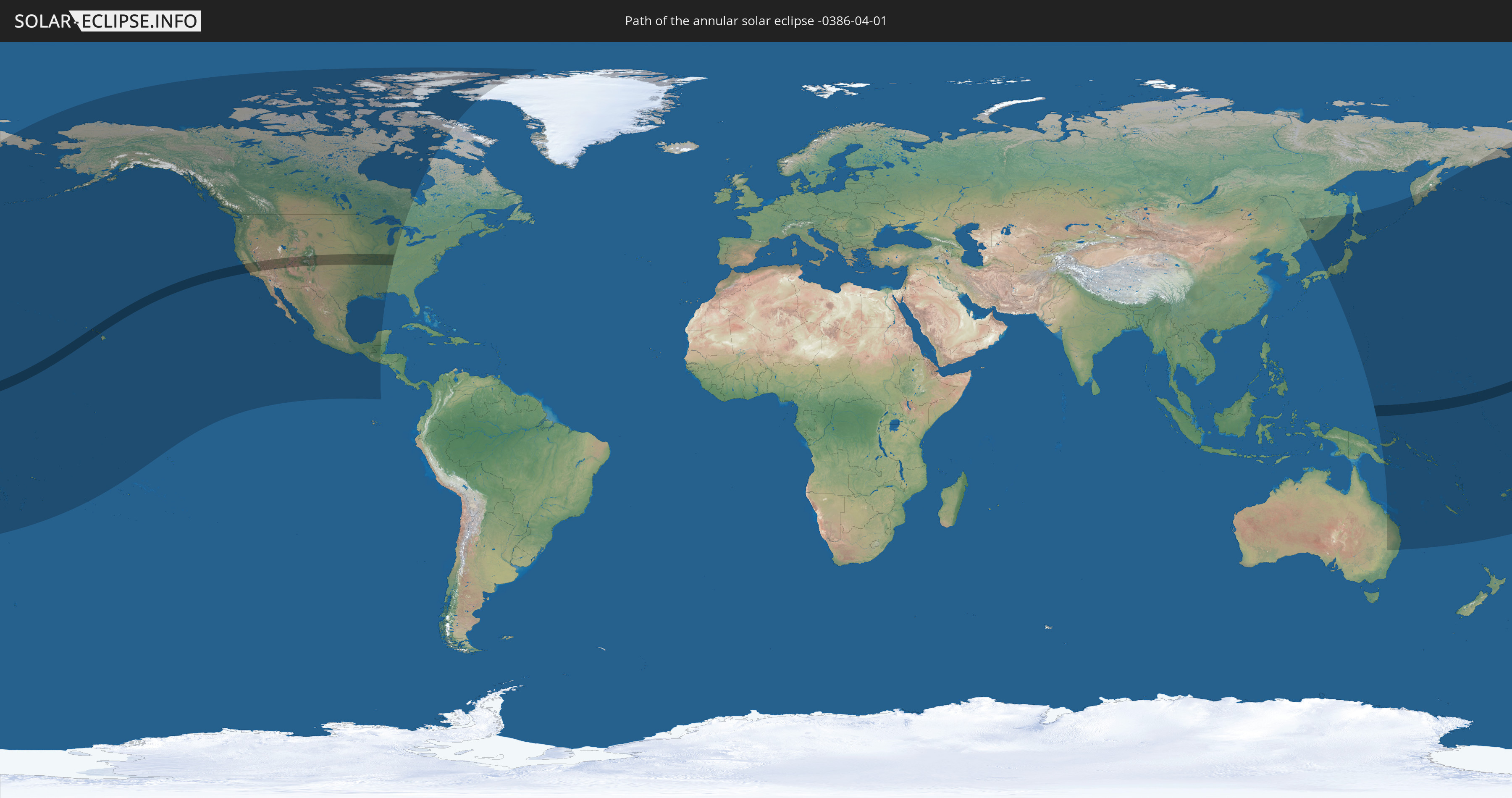
Die Sonnenfinsternis am 04/01/-0386 kann man in 32 Ländern als partielle Sonnenfinsternis beobachten.
Der Finsternispfad verläuft durch 3 Länder. Nur in diesen Ländern ist sie als annular Sonnenfinsternis zu sehen.
In den folgenden Ländern ist die Sonnenfinsternis annular zu sehen
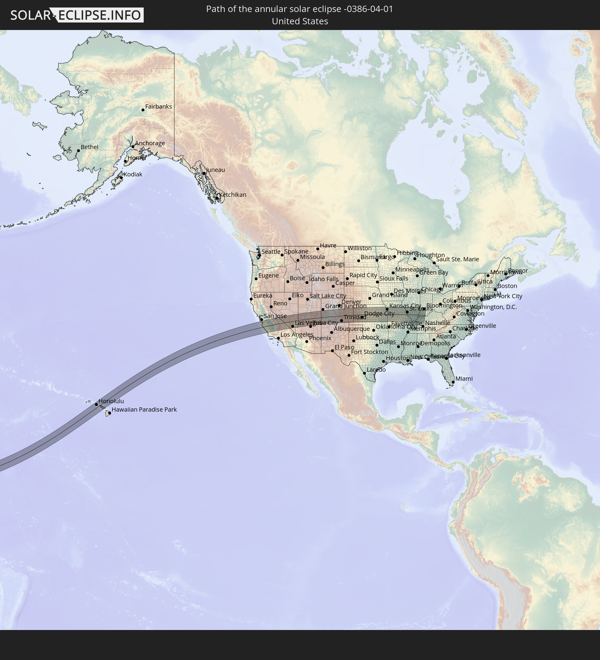 United States
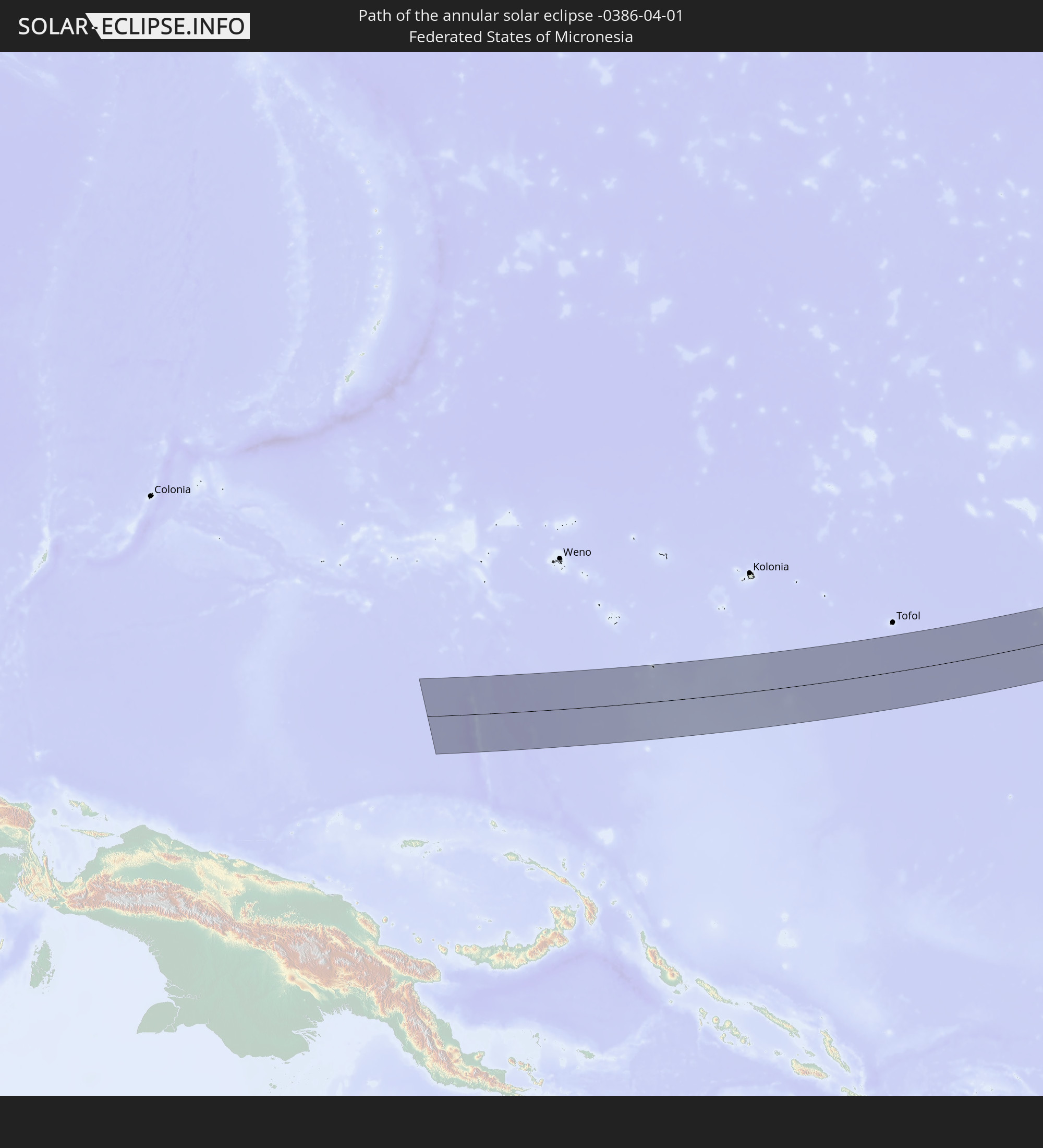 Federated States of Micronesia
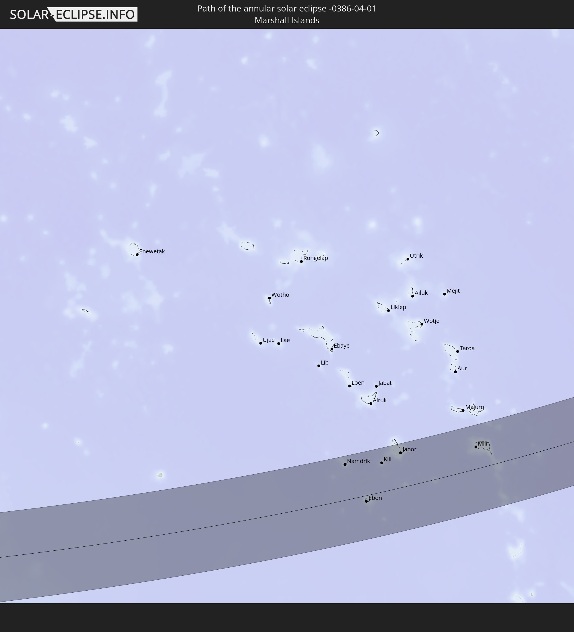 Marshall Islands
In den folgenden Ländern ist die Sonnenfinsternis partiell zu sehen
 Fiji
Fiji
 Russia
 United States
 United States Minor Outlying Islands
 Wallis and Futuna
 Tonga
Tonga
 Kiribati
 Samoa
Samoa
 Tokelau
 American Samoa
 Niue
Niue
 Cook Islands
 French Polynesia
 Canada
 Mexico
 Greenland
 Guatemala
 El Salvador
 China
China
 Australia
 Japan
Japan
 Federated States of Micronesia
 Papua New Guinea
 Guam
Guam
 Northern Mariana Islands
 Solomon Islands
 New Caledonia
 Marshall Islands
 Vanuatu
 Nauru
Nauru
 Norfolk Island
 Tuvalu
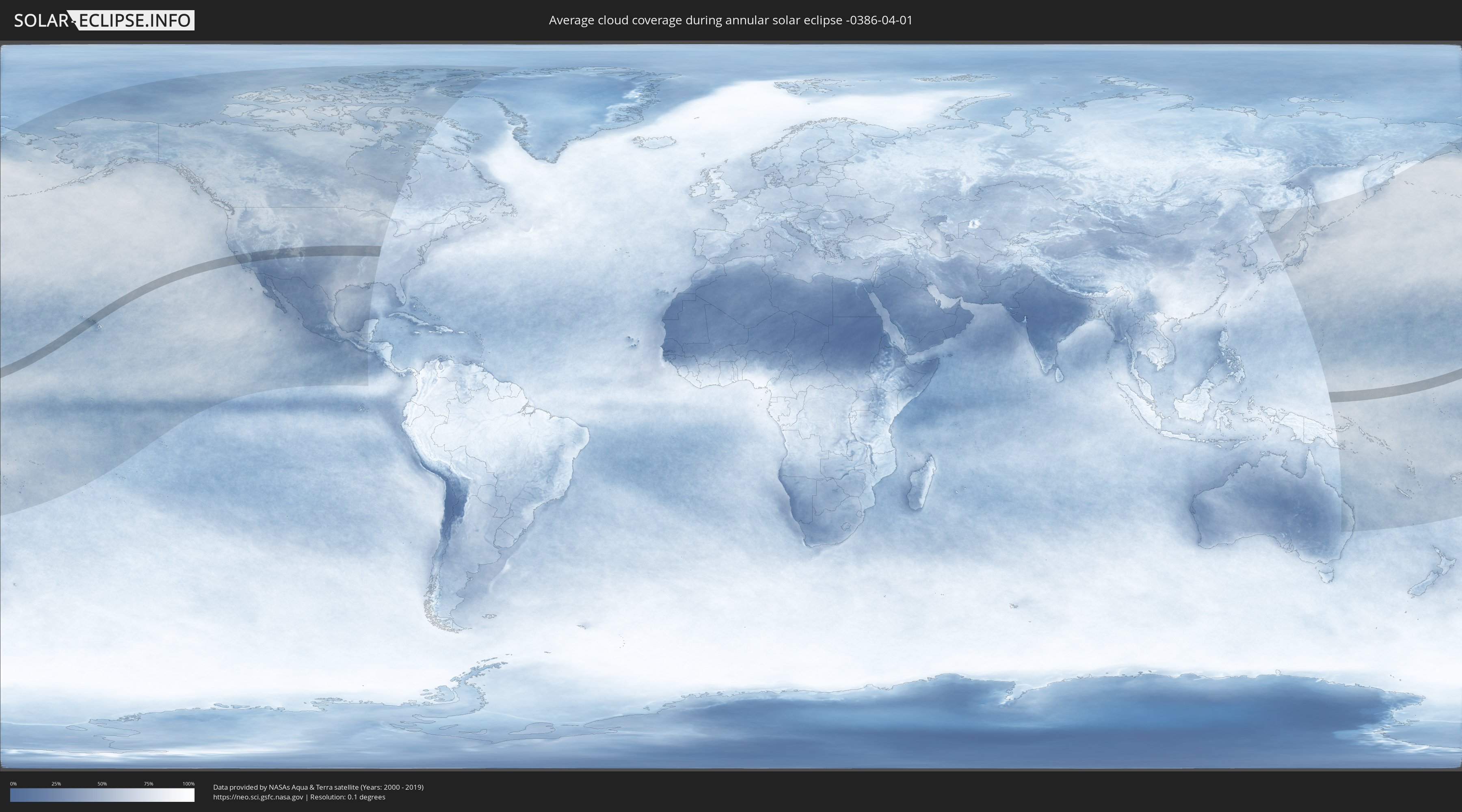
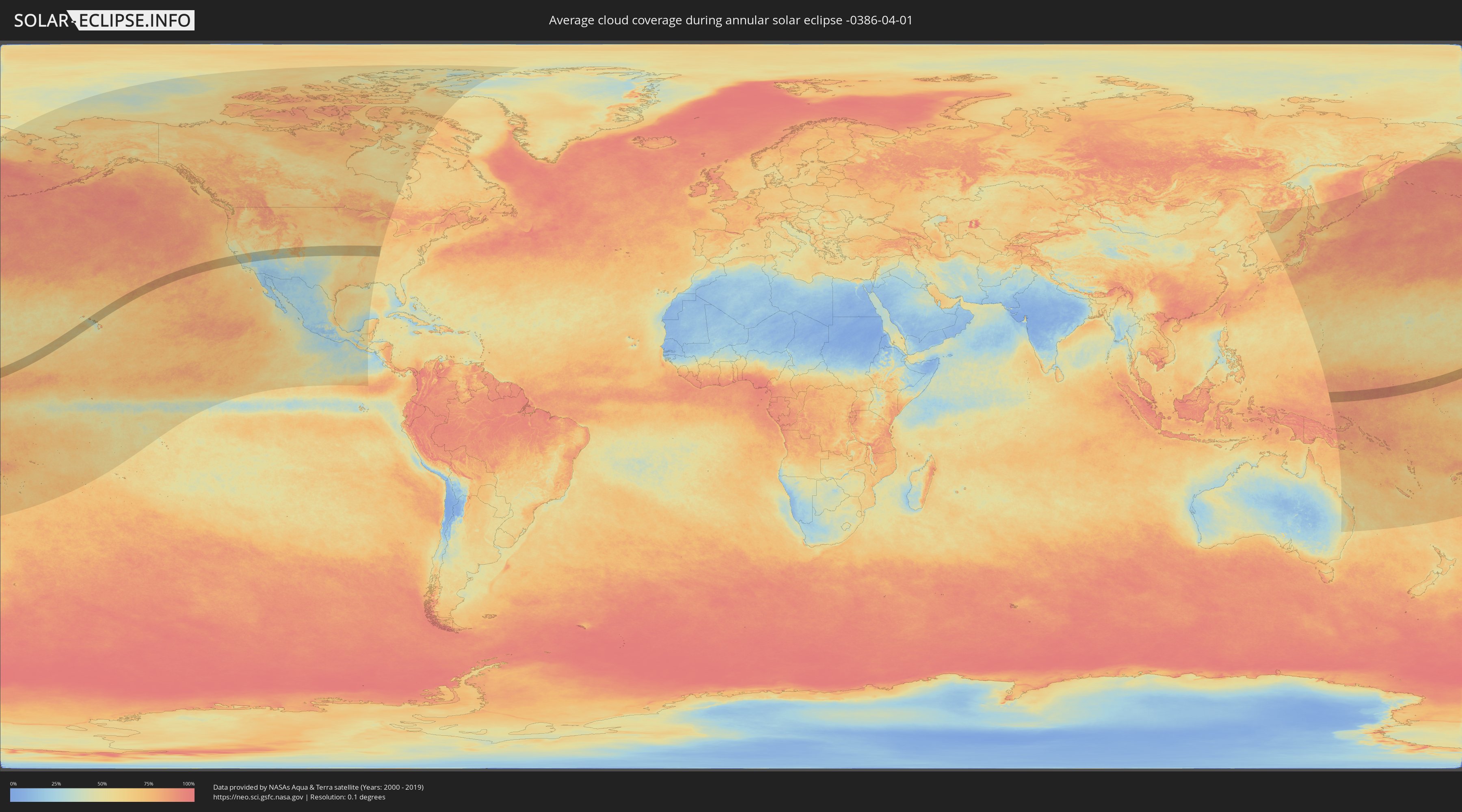
How will be the weather during the annular solar eclipse on 04/01/-0386?
Where is the best place to see the annular solar eclipse of 04/01/-0386?
The following maps show the average cloud coverage for the day of the annular solar eclipse.
With the help of these maps, it is possible to find the place along the eclipse path, which has the best
chance of a cloudless sky.
Nevertheless, you should consider local circumstances and inform about the weather of your chosen
observation site.
The data is provided by NASAs satellites
AQUA and TERRA.
The cloud maps are averaged over a period of 19 years (2000 - 2019).
Detailed country maps
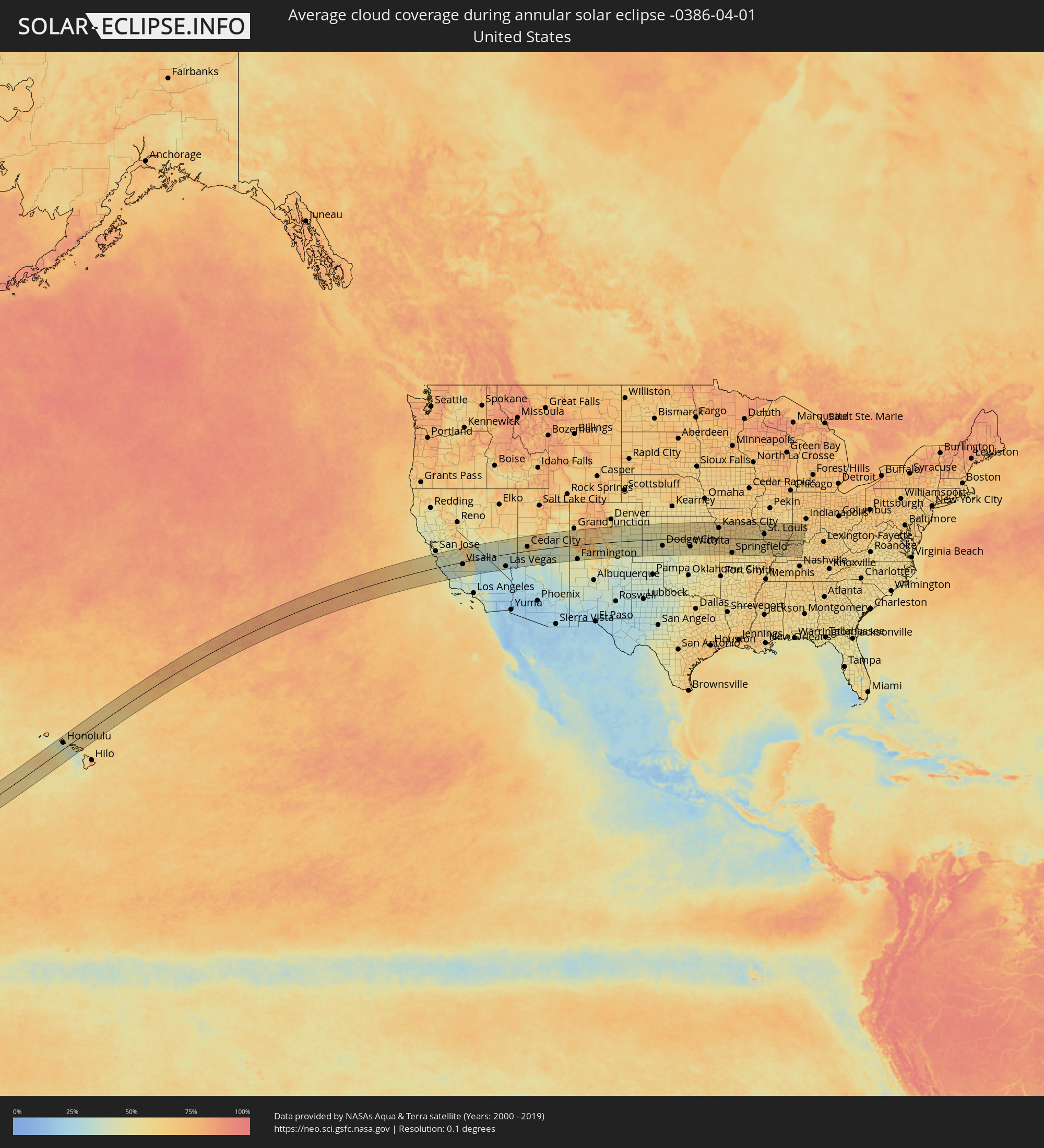 United States
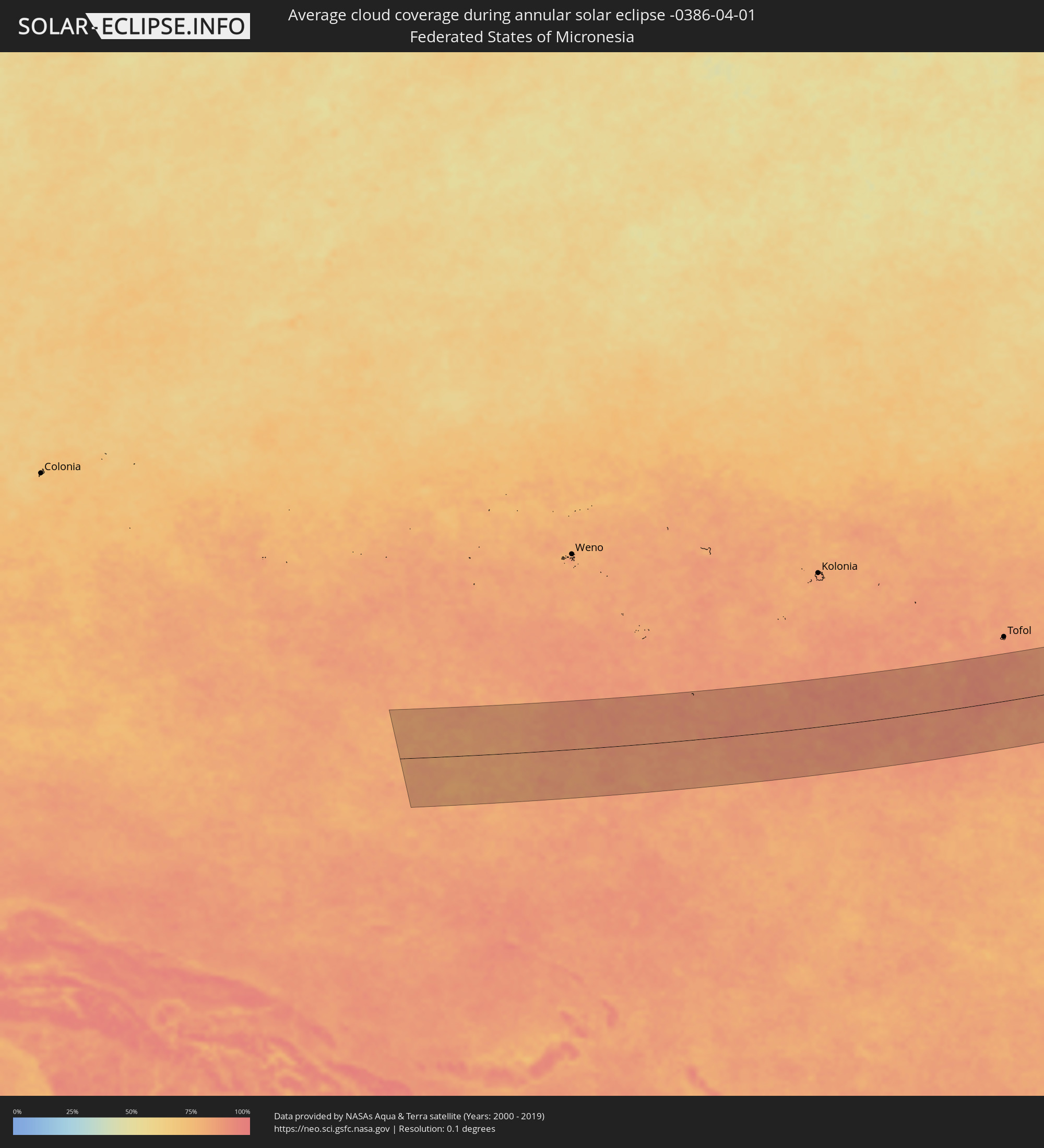 Federated States of Micronesia
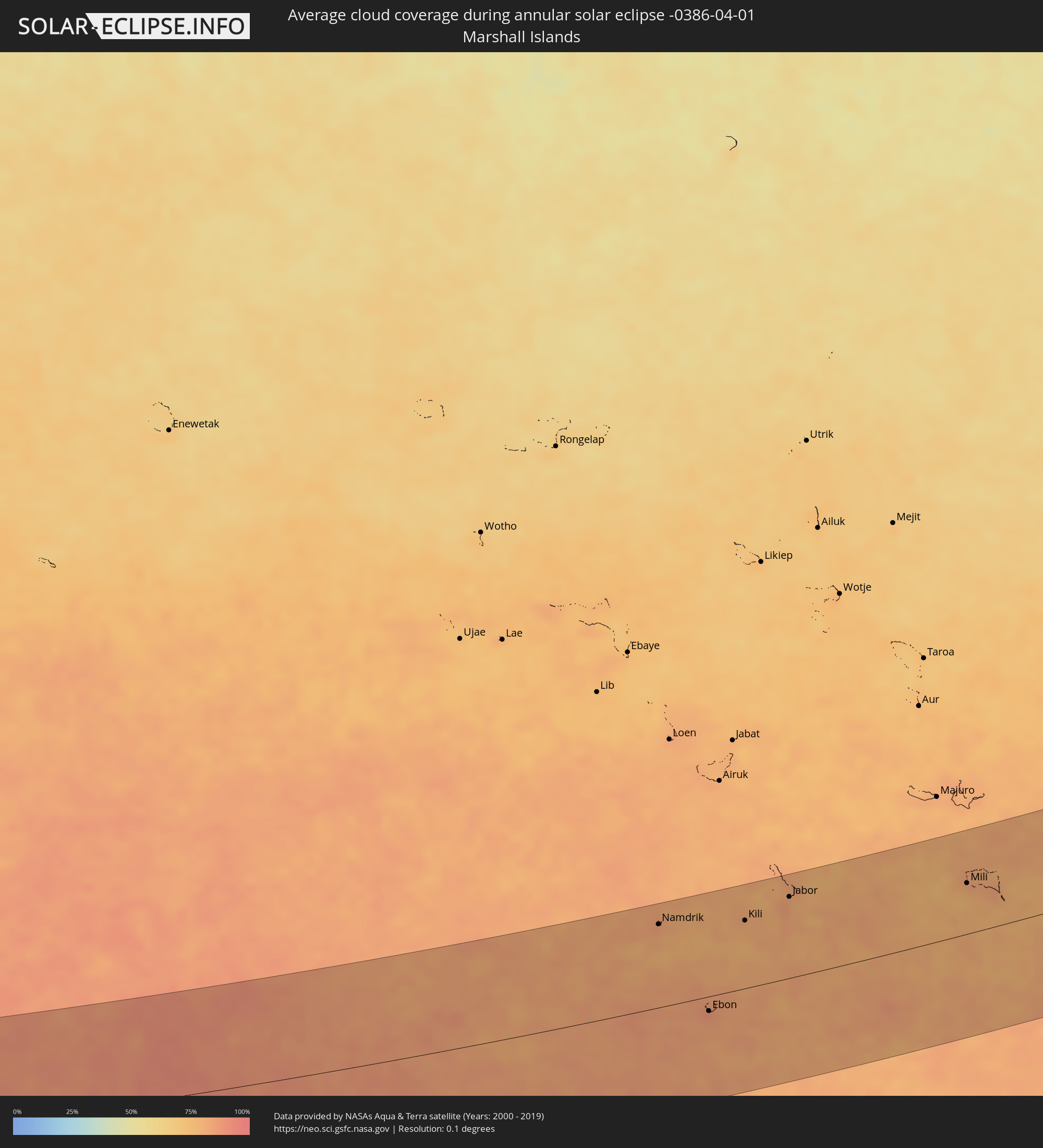 Marshall Islands
Cities inside the path of the eclipse
The following table shows all locations with a population of more than 5,000 inside the eclipse path. Cities which have more than 100,000 inhabitants are marked bold. A click at the locations opens a detailed map.
| City | Type | Eclipse duration | Local time of max. eclipse | Distance to central line | Ø Cloud coverage |
|
Pearl City, Hawaii
|
annular | - | 11:33:30 UTC-10:30 | 66 km | 61% |
|
Honolulu, Hawaii
|
annular | - | 11:33:38 UTC-10:30 | 51 km | 54% |
|
Kailua, Hawaii
|
annular | - | 11:34:10 UTC-10:30 | 53 km | 69% |
|
Kahului, Hawaii
|
annular | - | 11:36:42 UTC-10:30 | 70 km | 65% |
|
Santa Cruz, California
|
annular | - | 15:38:08 UTC-08:00 | 103 km | 46% |
|
Seaside, California
|
annular | - | 15:38:29 UTC-08:00 | 60 km | 45% |
|
Watsonville, California
|
annular | - | 15:38:30 UTC-08:00 | 91 km | 42% |
|
Salinas, California
|
annular | - | 15:38:43 UTC-08:00 | 64 km | 44% |
|
Morgan Hill, California
|
annular | - | 15:38:34 UTC-08:00 | 113 km | 45% |
|
Gilroy, California
|
annular | - | 15:38:43 UTC-08:00 | 98 km | 45% |
|
Hollister, California
|
annular | - | 15:38:59 UTC-08:00 | 78 km | 45% |
|
Soledad, California
|
annular | - | 15:39:12 UTC-08:00 | 30 km | 40% |
|
Los Banos, California
|
annular | - | 15:39:36 UTC-08:00 | 89 km | 44% |
|
Paso Robles, California
|
annular | - | 15:40:15 UTC-08:00 | 69 km | 37% |
|
Atascadero, California
|
annular | - | 15:40:19 UTC-08:00 | 85 km | 35% |
|
San Luis Obispo, California
|
annular | - | 15:40:23 UTC-08:00 | 107 km | 38% |
|
Merced, California
|
annular | - | 15:39:57 UTC-08:00 | 109 km | 47% |
|
Chowchilla, California
|
annular | - | 15:40:17 UTC-08:00 | 85 km | 47% |
|
Avenal, California
|
annular | - | 15:40:50 UTC-08:00 | 39 km | 40% |
|
Madera, California
|
annular | - | 15:40:35 UTC-08:00 | 64 km | 46% |
|
Fresno, California
|
annular | - | 15:41:01 UTC-08:00 | 36 km | 44% |
|
Hanford, California
|
annular | - | 15:41:19 UTC-08:00 | 13 km | 41% |
|
Corcoran, California
|
annular | - | 15:41:30 UTC-08:00 | 39 km | 41% |
|
Sanger, California
|
annular | - | 15:41:17 UTC-08:00 | 27 km | 43% |
|
Reedley, California
|
annular | - | 15:41:27 UTC-08:00 | 13 km | 42% |
|
Wasco, California
|
annular | - | 15:41:56 UTC-08:00 | 98 km | 39% |
|
Visalia, California
|
annular | - | 15:41:44 UTC-08:00 | 19 km | 43% |
|
Delano, California
|
annular | - | 15:41:59 UTC-08:00 | 81 km | 43% |
|
Porterville, California
|
annular | - | 15:42:09 UTC-08:00 | 52 km | 45% |
|
Pahrump, Nevada
|
annular | - | 15:45:27 UTC-08:00 | 86 km | 33% |
|
Enterprise, Nevada
|
annular | - | 15:46:18 UTC-08:00 | 117 km | 31% |
|
Las Vegas, Nevada
|
annular | - | 15:46:20 UTC-08:00 | 102 km | 32% |
|
Henderson, Nevada
|
annular | - | 15:46:33 UTC-08:00 | 119 km | 30% |
|
Mesquite, Nevada
|
annular | - | 15:47:05 UTC-08:00 | 48 km | 31% |
|
Saint George, Utah
|
annular | - | 16:47:23 UTC-07:00 | 21 km | 36% |
|
Cedar City, Utah
|
annular | - | 16:47:33 UTC-07:00 | 36 km | 56% |
|
Farmington, New Mexico
|
annular | - | 16:51:57 UTC-07:00 | 120 km | 44% |
|
Durango, Colorado
|
annular | - | 16:51:51 UTC-07:00 | 62 km | 50% |
|
Montrose, Colorado
|
annular | - | 16:51:05 UTC-07:00 | 71 km | 57% |
|
Cañon City, Colorado
|
annular | - | 16:52:45 UTC-07:00 | 47 km | 48% |
|
Colorado Springs, Colorado
|
annular | - | 16:52:43 UTC-07:00 | 88 km | 53% |
|
Fountain, Colorado
|
annular | - | 16:52:53 UTC-07:00 | 71 km | 50% |
|
Pueblo, Colorado
|
annular | - | 16:53:14 UTC-07:00 | 23 km | 45% |
|
Liberal, Kansas
|
annular | - | 17:55:52 UTC-06:00 | 130 km | 47% |
|
Garden City, Kansas
|
annular | - | 17:55:15 UTC-06:00 | 27 km | 45% |
|
Dodge City, Kansas
|
annular | - | 17:55:45 UTC-06:00 | 54 km | 47% |
|
Hays, Kansas
|
annular | - | 17:55:11 UTC-06:00 | 70 km | 55% |
|
Great Bend, Kansas
|
annular | - | 17:55:46 UTC-06:00 | 11 km | 52% |
|
Hutchinson, Kansas
|
annular | - | 17:56:16 UTC-06:00 | 25 km | 54% |
|
Salina, Kansas
|
annular | - | 17:55:47 UTC-06:00 | 62 km | 57% |
|
Newton, Kansas
|
annular | - | 17:56:27 UTC-06:00 | 27 km | 55% |
|
Wichita, Kansas
|
annular | - | 17:56:43 UTC-06:00 | 67 km | 55% |
|
Derby, Kansas
|
annular | - | 17:56:50 UTC-06:00 | 83 km | 51% |
|
Junction City, Kansas
|
annular | - | 17:55:52 UTC-06:00 | 82 km | 59% |
|
Manhattan, Kansas
|
annular | - | 17:55:49 UTC-06:00 | 99 km | 58% |
|
Emporia, Kansas
|
annular | - | 17:56:31 UTC-06:00 | 11 km | 55% |
|
Topeka, Kansas
|
annular | - | 17:56:09 UTC-06:00 | 83 km | 57% |
|
Lawrence, Kansas
|
annular | - | 17:56:19 UTC-06:00 | 74 km | 59% |
|
Leavenworth, Kansas
|
annular | - | 17:56:08 UTC-06:00 | 112 km | 60% |
|
Olathe, Kansas
|
annular | - | 17:56:29 UTC-06:00 | 64 km | 61% |
|
Pittsburg, Kansas
|
annular | - | 17:57:36 UTC-06:00 | 100 km | 63% |
|
Overland Park, Kansas
|
annular | - | 17:56:26 UTC-06:00 | 75 km | 59% |
|
Kansas City, Missouri
|
annular | - | 17:56:22 UTC-06:00 | 88 km | 60% |
|
Belton, Missouri
|
annular | - | 17:56:36 UTC-06:00 | 56 km | 61% |
|
Joplin, Missouri
|
annular | - | 17:57:52 UTC-06:00 | 136 km | 62% |
|
Liberty, Missouri
|
annular | - | 17:56:17 UTC-06:00 | 105 km | 61% |
|
Lee's Summit, Missouri
|
annular | - | 17:56:33 UTC-06:00 | 67 km | 62% |
|
East Independence, Missouri
|
annular | - | 17:56:25 UTC-06:00 | 88 km | 61% |
|
Warrensburg, Missouri
|
annular | - | 17:56:47 UTC-06:00 | 51 km | 65% |
|
Republic, Missouri
|
annular | - | 17:58:03 UTC-06:00 | 131 km | 63% |
|
Springfield, Missouri
|
annular | - | 17:58:01 UTC-06:00 | 121 km | 64% |
|
Sedalia, Missouri
|
annular | - | 17:56:55 UTC-06:00 | 45 km | 66% |
|
Columbia, Missouri
|
annular | - | 17:56:52 UTC-06:00 | 74 km | 63% |
|
Jefferson City, Missouri
|
annular | - | 17:57:11 UTC-06:00 | 32 km | 59% |
|
Fort Leonard Wood, Missouri
|
annular | - | 17:57:50 UTC-06:00 | 65 km | 59% |
|
Rolla, Missouri
|
annular | - | 17:57:42 UTC-06:00 | 37 km | 60% |
|
O'Fallon, Missouri
|
annular | - | 17:57:10 UTC-06:00 | 61 km | 60% |
|
Chesterfield, Missouri
|
annular | - | 17:57:18 UTC-06:00 | 45 km | 56% |
|
Saint Charles, Missouri
|
annular | - | 17:57:13 UTC-06:00 | 58 km | 58% |
|
Farmington, Missouri
|
annular | - | 17:57:58 UTC-06:00 | 53 km | 53% |
|
Kirkwood, Missouri
|
annular | - | 17:57:22 UTC-06:00 | 36 km | 57% |
|
Ferguson, Missouri
|
annular | - | 17:57:15 UTC-06:00 | 55 km | 57% |
|
Oakville, Missouri
|
annular | - | 17:57:28 UTC-06:00 | 24 km | 56% |
|
St. Louis, Missouri
|
annular | - | 17:57:21 UTC-06:00 | 42 km | 58% |
|
Upper Alton, Illinois
|
annular | - | 17:57:08 UTC-06:00 | 74 km | 56% |
|
Collinsville, Illinois
|
annular | - | 17:57:20 UTC-06:00 | 47 km | 57% |
|
Belleville, Illinois
|
annular | - | 17:57:27 UTC-06:00 | 30 km | 62% |
|
Edwardsville, Illinois
|
annular | - | 17:57:14 UTC-06:00 | 63 km | 58% |
|
Cape Girardeau, Missouri
|
annular | - | 17:58:23 UTC-06:00 | 103 km | 60% |
|
Carbondale, Illinois
|
annular | - | 17:58:05 UTC-06:00 | 56 km | 57% |
|
Marion, Illinois
|
annular | - | 17:58:06 UTC-06:00 | 54 km | 59% |
|
Mount Vernon, Illinois
|
annular | - | 17:57:40 UTC-06:00 | 11 km | 63% |
|
Paducah, Kentucky
|
annular | - | 17:58:35 UTC-06:00 | 125 km | 57% |
|
Henderson, Kentucky
|
annular | - | 17:58:03 UTC-06:00 | 38 km | 66% |
|
Evansville, Indiana
|
annular | - | 17:57:57 UTC-06:00 | 22 km | 66% |
|
Vincennes, Indiana
|
annular | - | 18:57:25 UTC-05:00 | 56 km | 67% |
|
Madisonville, Kentucky
|
annular | - | 17:58:25 UTC-06:00 | 94 km | 59% |
|
Owensboro, Kentucky
|
annular | - | 17:58:06 UTC-06:00 | 43 km | 65% |
|
Jasper, Indiana
|
annular | - | 18:57:38 UTC-05:00 | 26 km | 63% |
|
Bloomington, Indiana
|
annular | - | 18:57:02 UTC-05:00 | 114 km | 64% |
|
Namdrik, Namdrik Atoll
|
annular | - | 07:27:05 UTC+11:00 | 106 km | 84% |
|
Ebon, Ebon Atoll
|
annular | - | 07:26:24 UTC+11:00 | 19 km | 88% |
|
Kili, Kili Island
|
annular | - | 07:28:05 UTC+11:00 | 86 km | 79% |
|
Jabor, Jaluit Atoll
|
annular | - | 07:28:56 UTC+11:00 | 103 km | 85% |
|
Mili, Mili Atoll
|
annular | - | 07:31:19 UTC+11:00 | 64 km | 80% |