Total solar eclipse of 06/05/0848
| Day of week: | Friday |
| Maximum duration of eclipse: | 04m59s |
| Maximum width of eclipse path: | 180 km |
| Saros cycle: | 99 |
| Coverage: | 100% |
| Magnitude: | 1.0545 |
| Gamma: | 0.0424 |
Wo kann man die Sonnenfinsternis vom 06/05/0848 sehen?
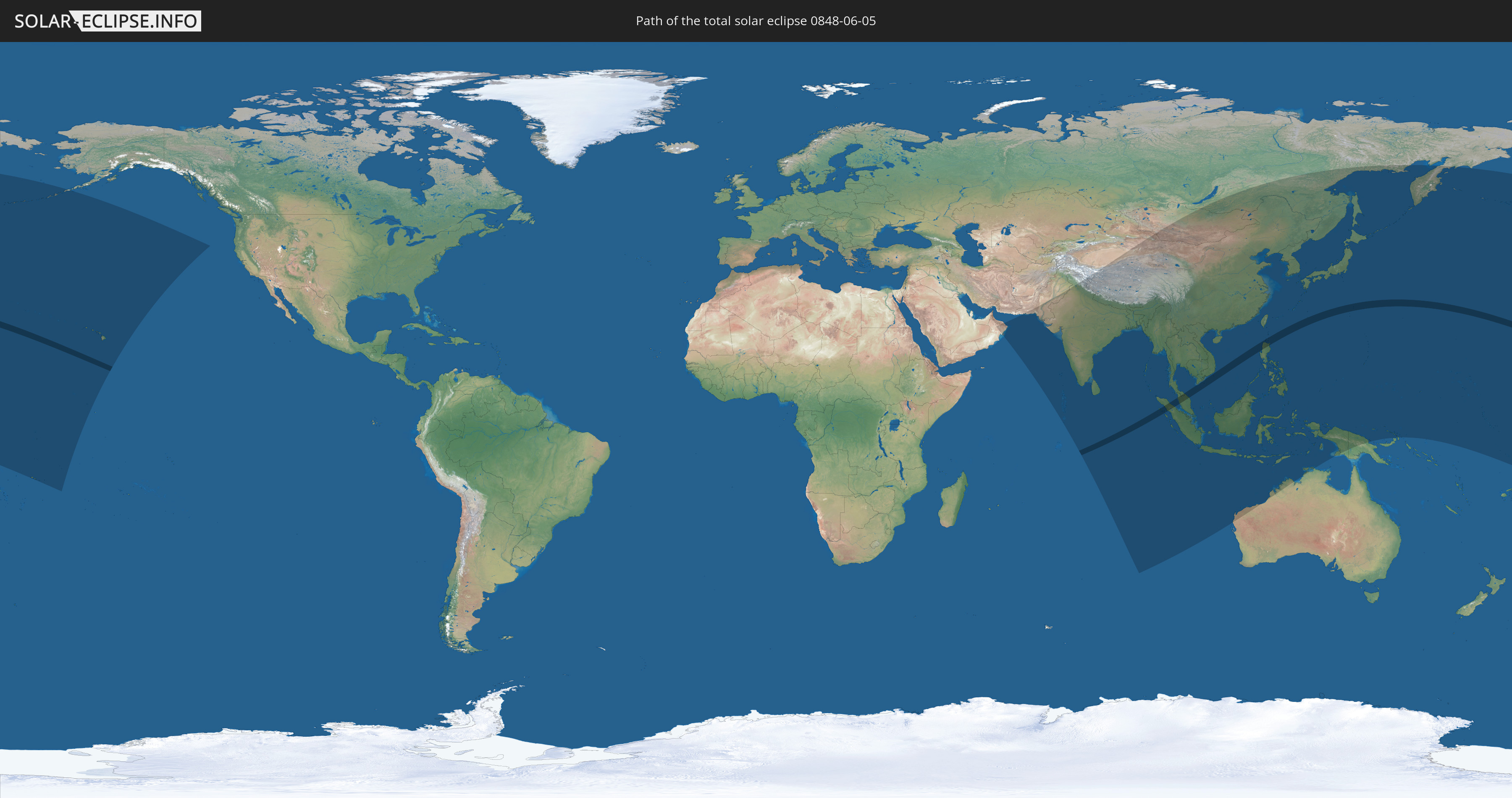
Die Sonnenfinsternis am 06/05/0848 kann man in 46 Ländern als partielle Sonnenfinsternis beobachten.
Der Finsternispfad verläuft durch 6 Länder. Nur in diesen Ländern ist sie als total Sonnenfinsternis zu sehen.
In den folgenden Ländern ist die Sonnenfinsternis total zu sehen
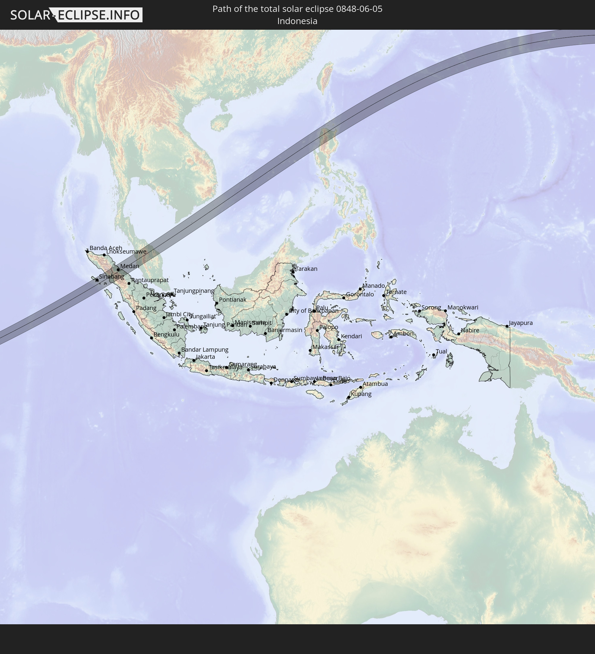 Indonesia
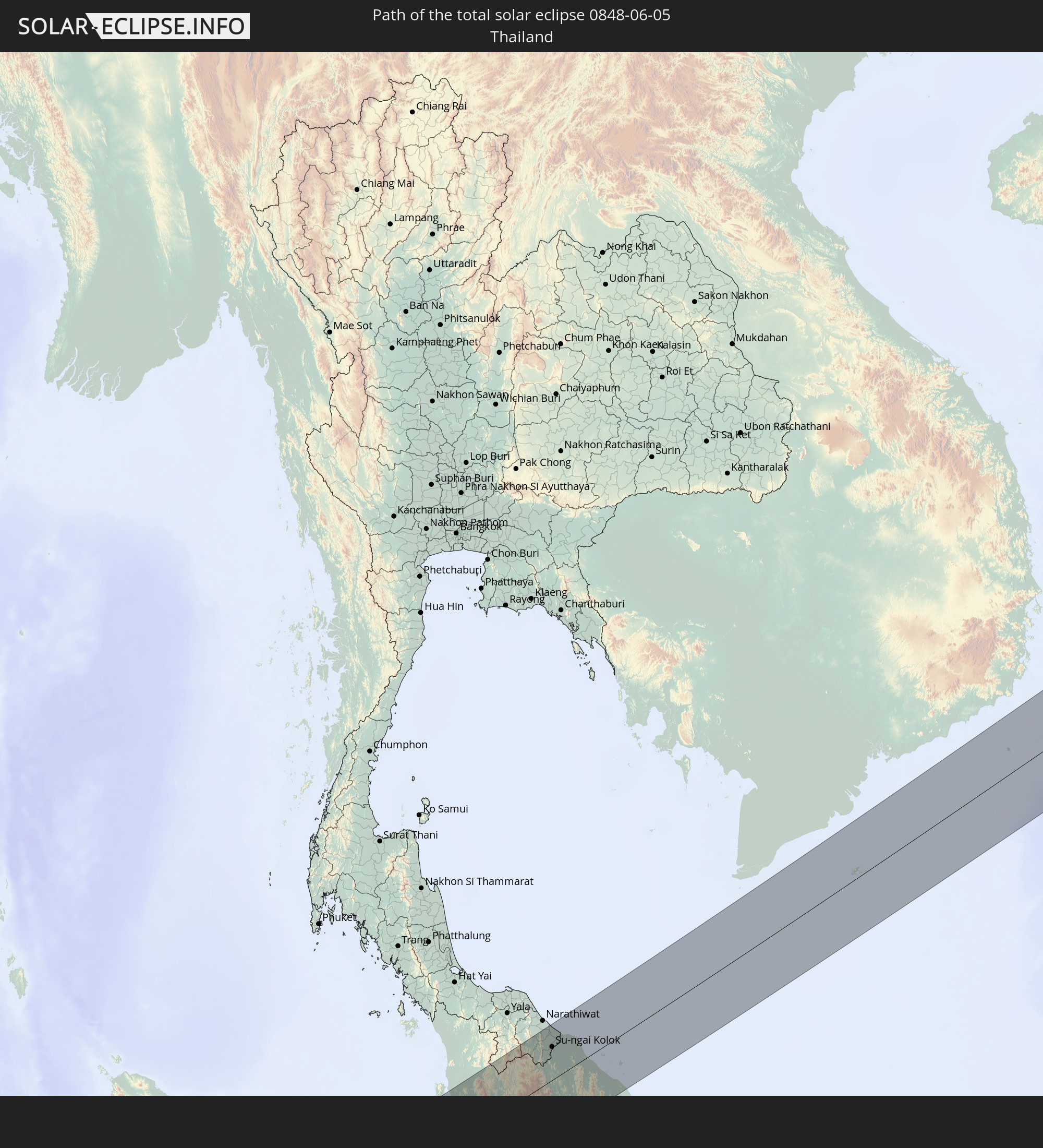 Thailand
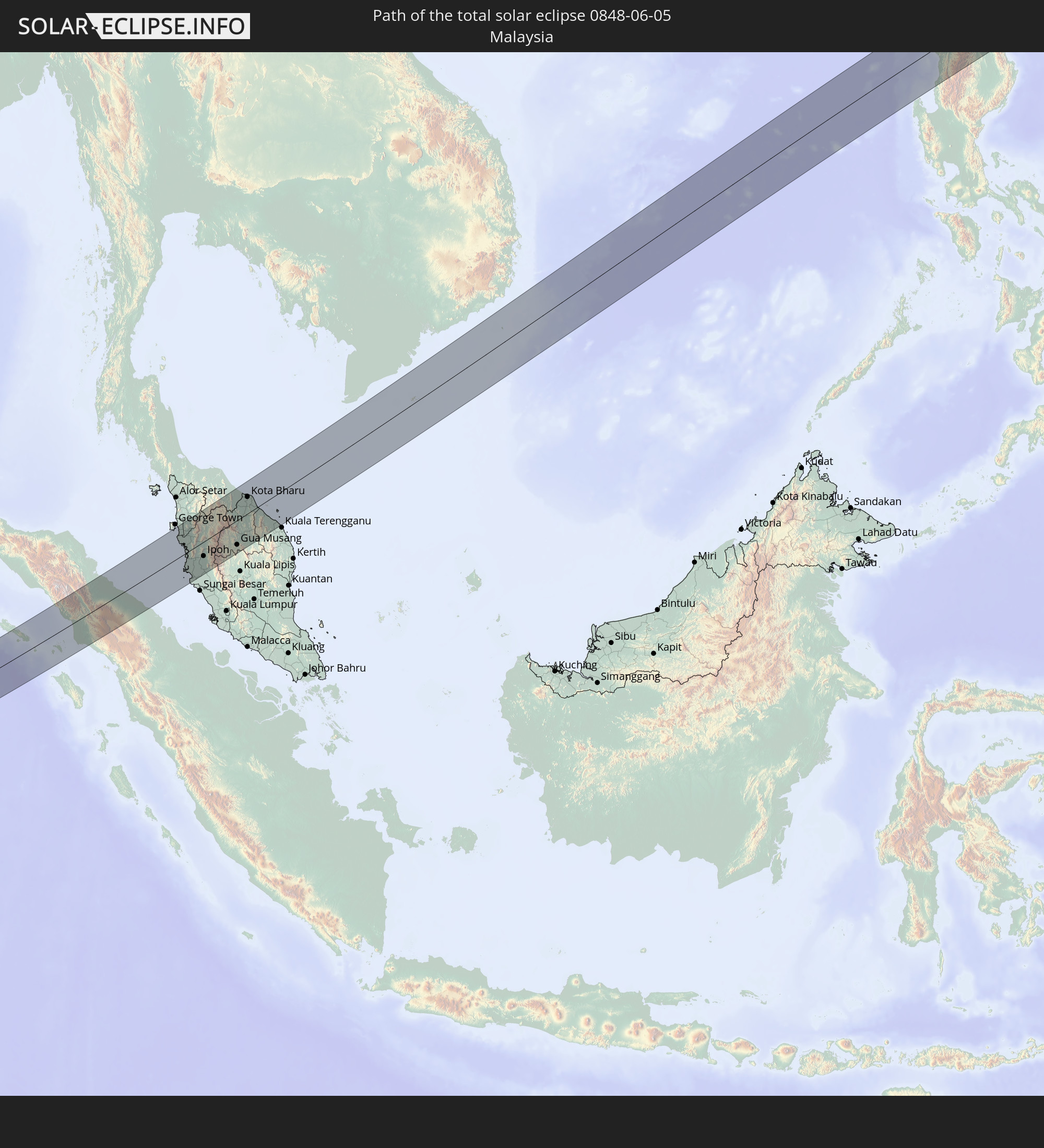 Malaysia
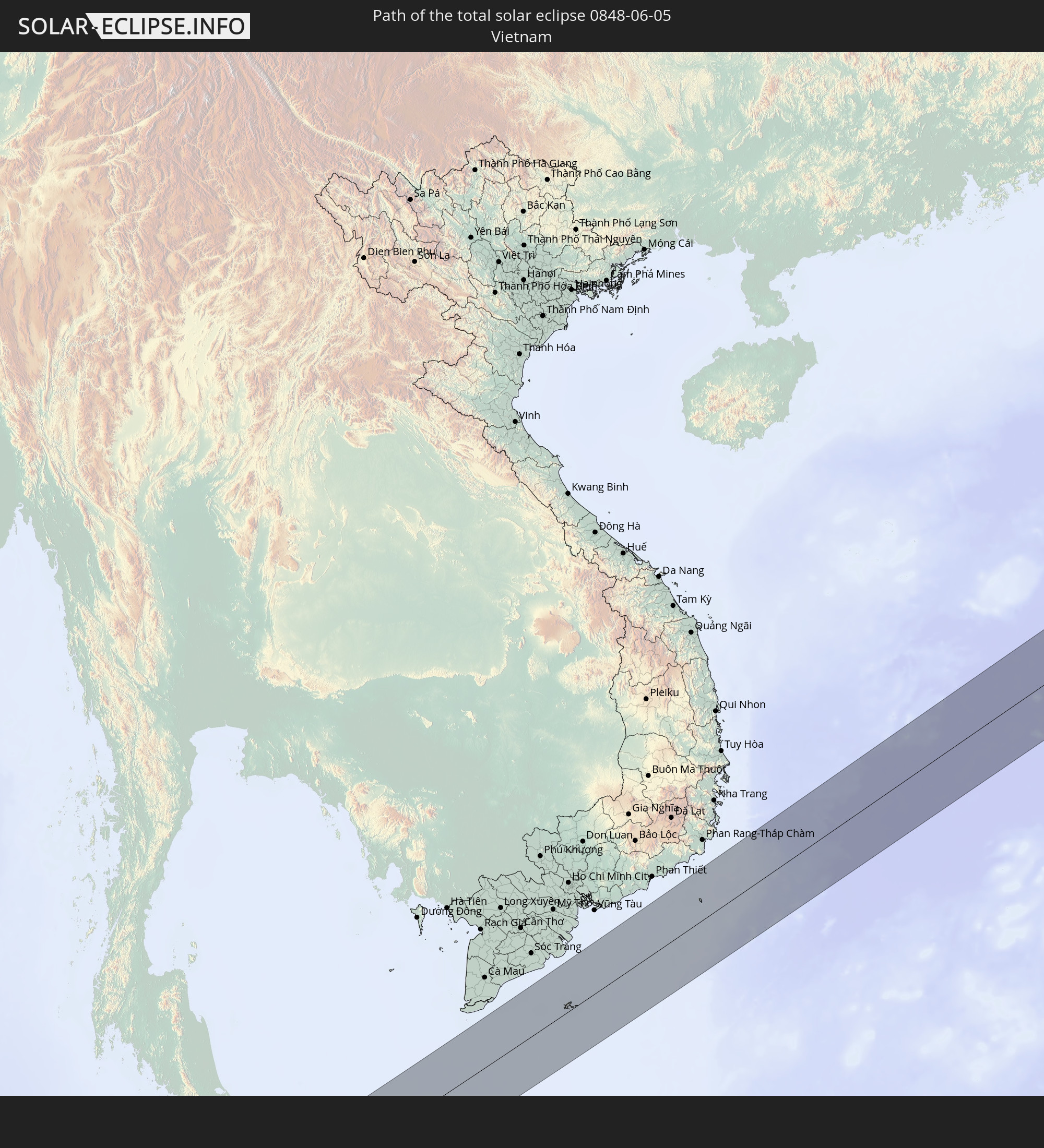 Vietnam
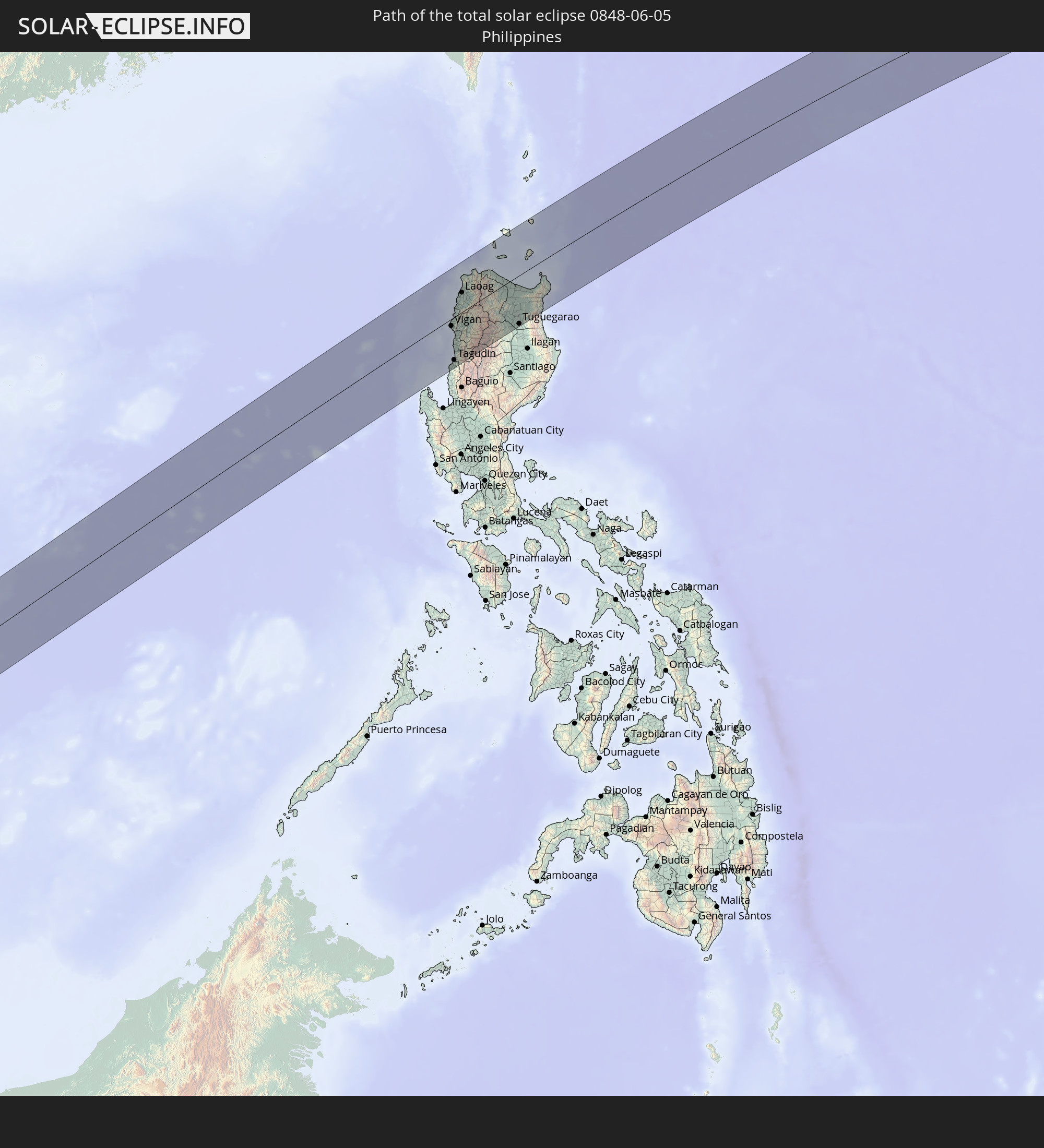 Philippines
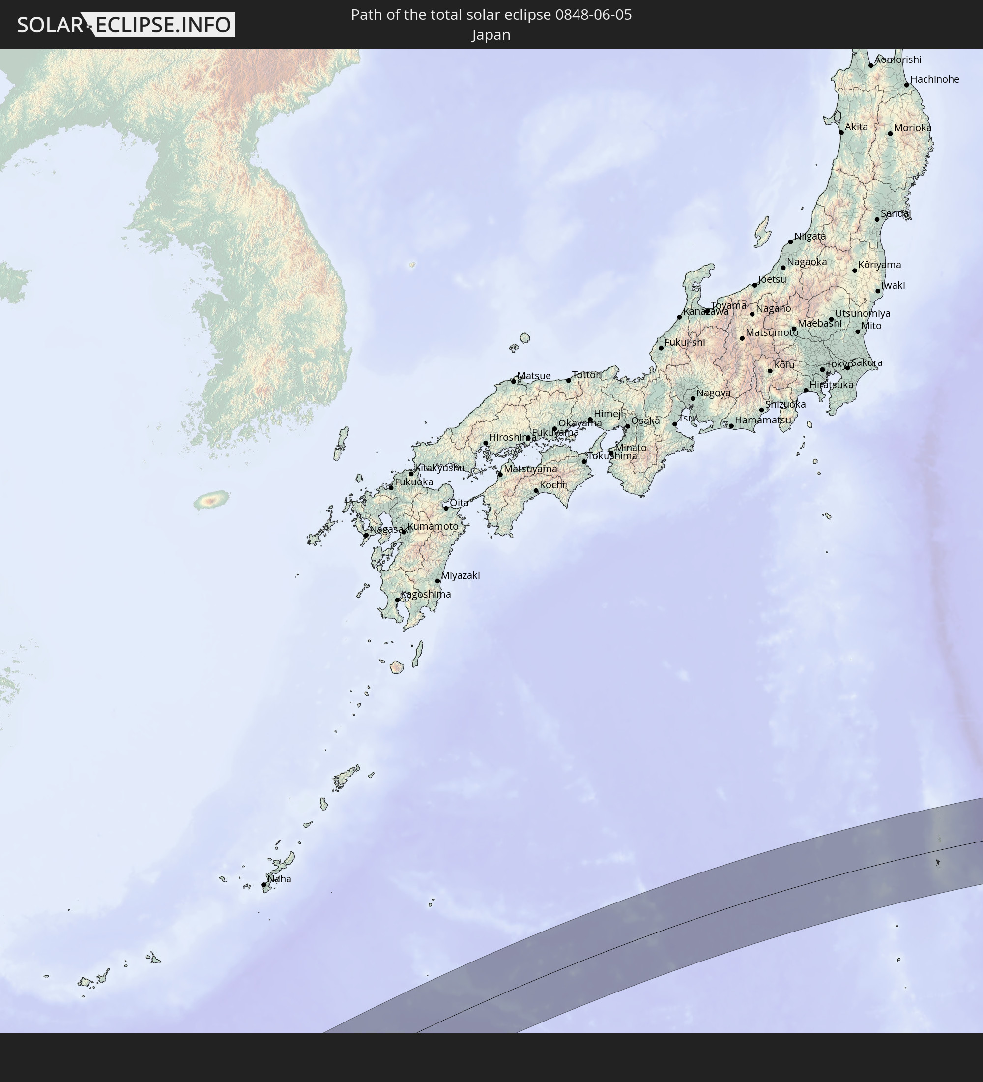 Japan
Japan
In den folgenden Ländern ist die Sonnenfinsternis partiell zu sehen
 Russia
 United States
 United States Minor Outlying Islands
 Kiribati
 Samoa
Samoa
 Tokelau
 American Samoa
 Cook Islands
 Oman
Oman
 Pakistan
 India
India
 Maldives
 China
China
 Sri Lanka
 Nepal
Nepal
 Mongolia
 Bangladesh
 Bhutan
 Myanmar
 Indonesia
 Cocos Islands
 Thailand
 Malaysia
 Laos
Laos
 Vietnam
 Cambodia
 Singapore
 Christmas Island
 Australia
 Macau
Macau
 Hong Kong
 Brunei
 Taiwan
 Philippines
 Japan
Japan
 East Timor
 North Korea
 South Korea
 Palau
Palau
 Federated States of Micronesia
 Papua New Guinea
 Guam
Guam
 Northern Mariana Islands
 Marshall Islands
 Nauru
Nauru
 Tuvalu
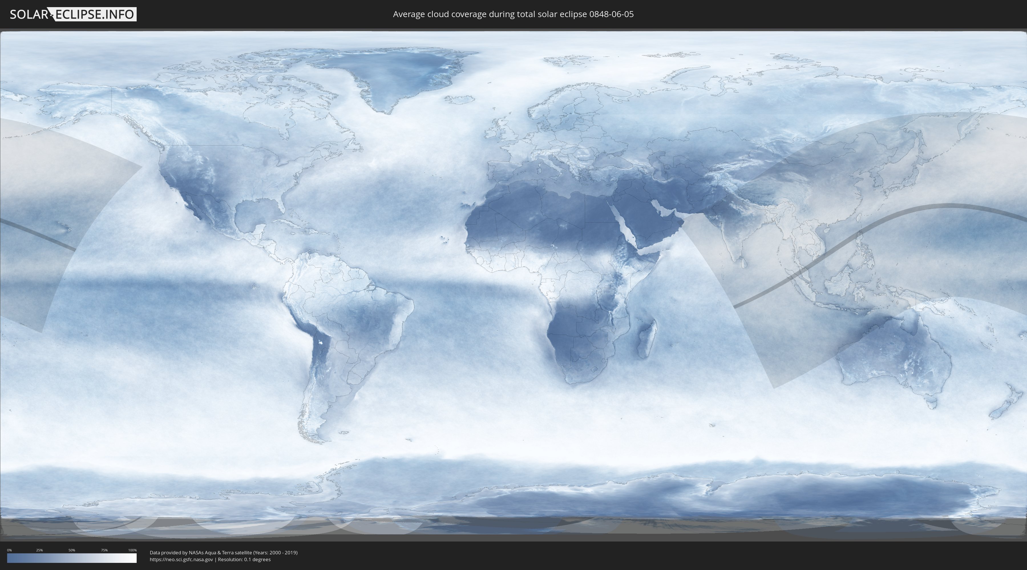
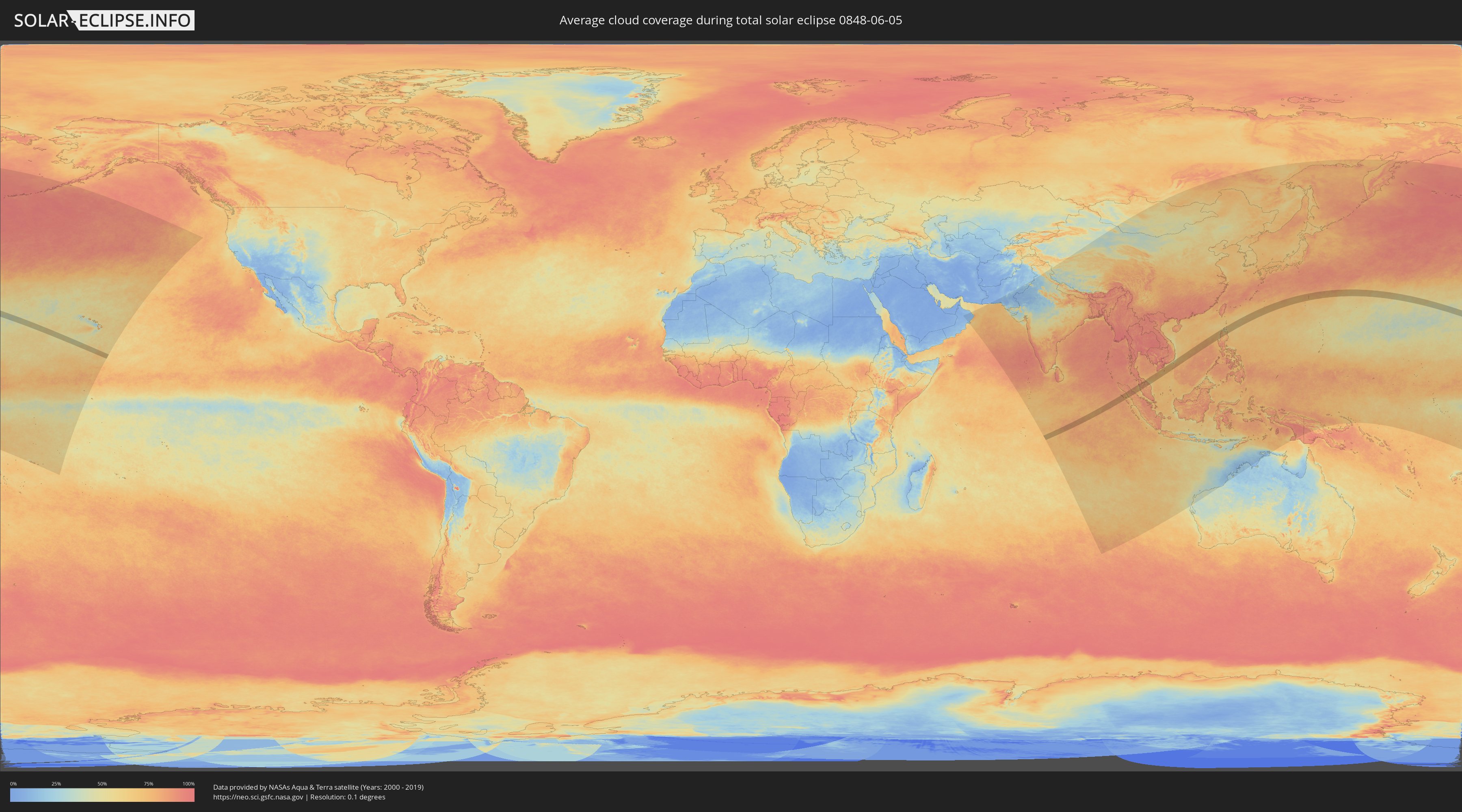
How will be the weather during the total solar eclipse on 06/05/0848?
Where is the best place to see the total solar eclipse of 06/05/0848?
The following maps show the average cloud coverage for the day of the total solar eclipse.
With the help of these maps, it is possible to find the place along the eclipse path, which has the best
chance of a cloudless sky.
Nevertheless, you should consider local circumstances and inform about the weather of your chosen
observation site.
The data is provided by NASAs satellites
AQUA and TERRA.
The cloud maps are averaged over a period of 19 years (2000 - 2019).
Detailed country maps
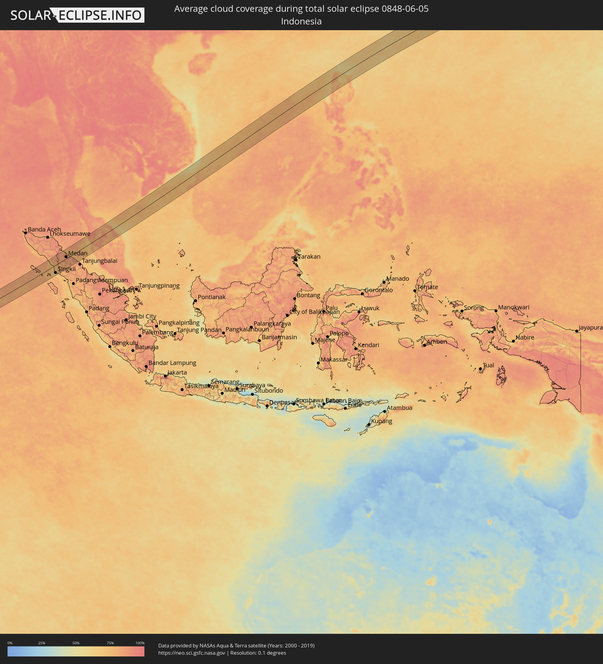 Indonesia
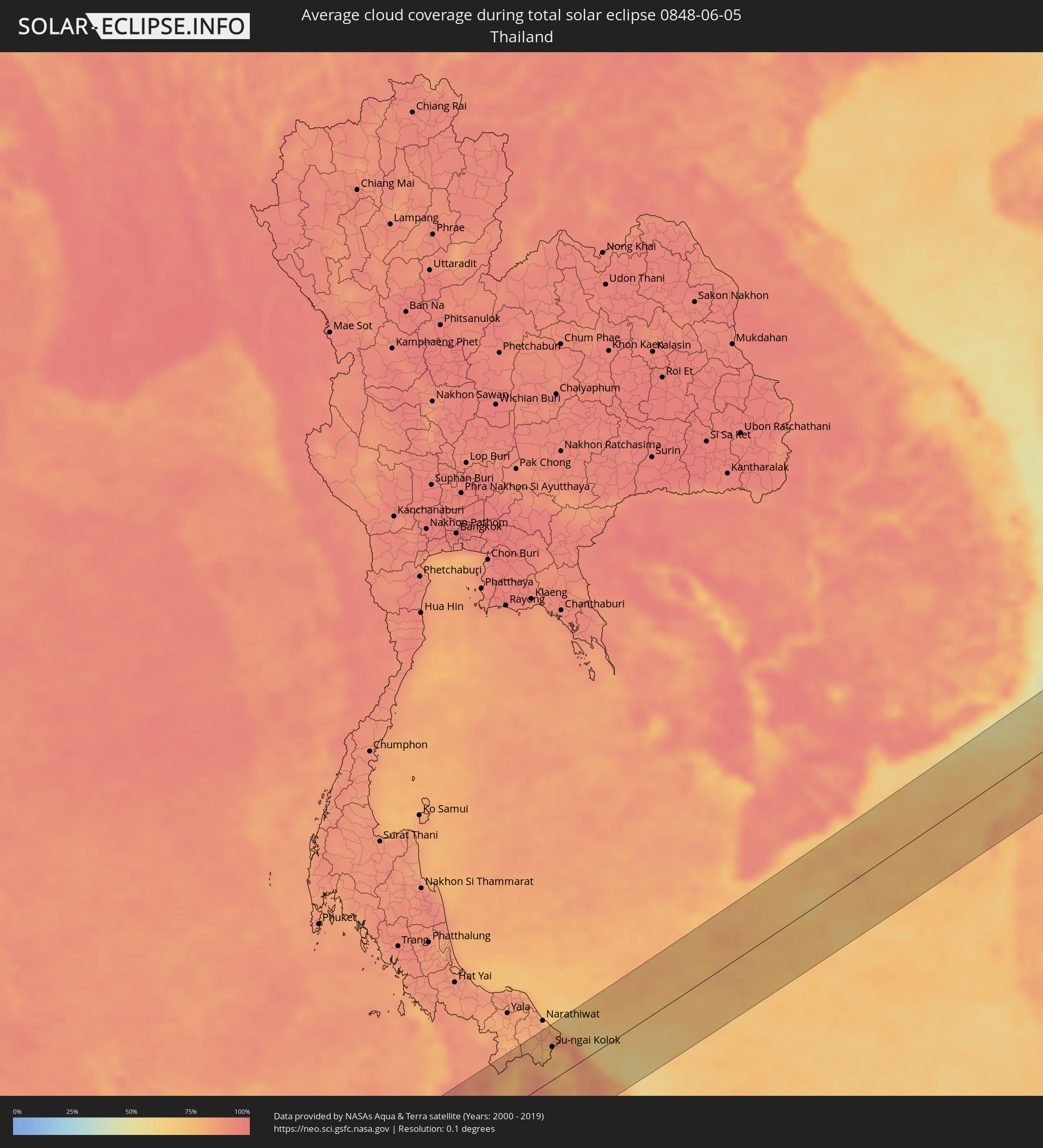 Thailand
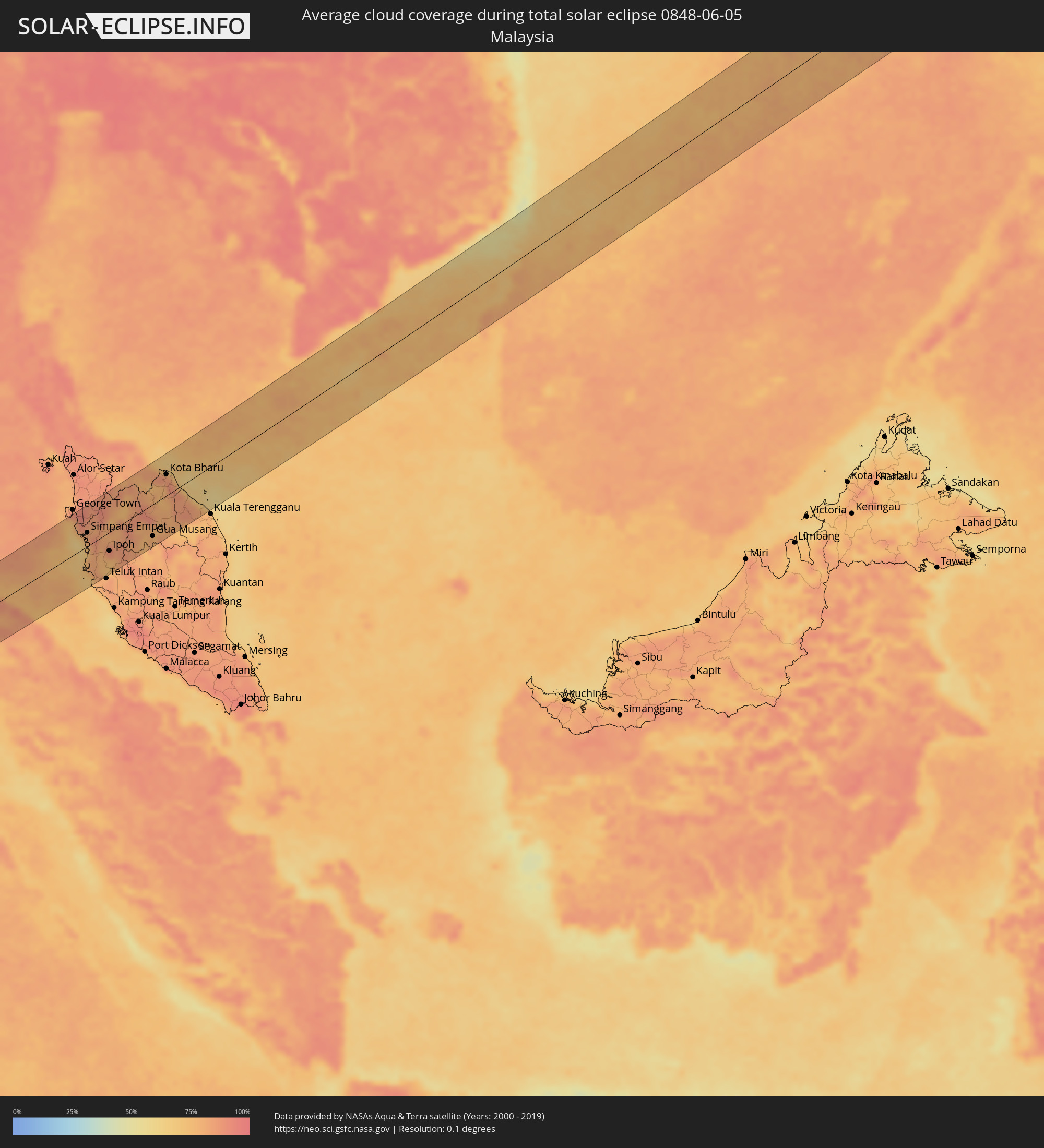 Malaysia
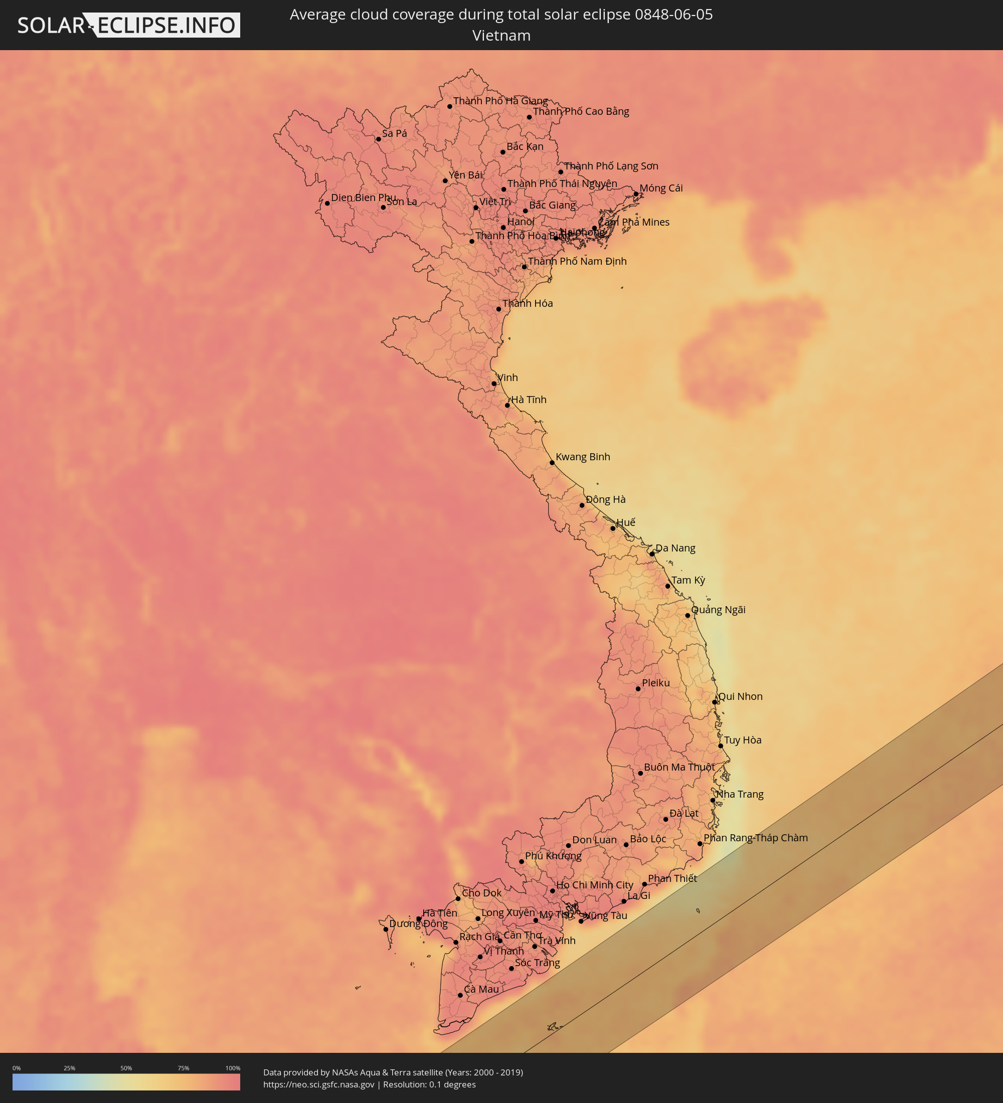 Vietnam
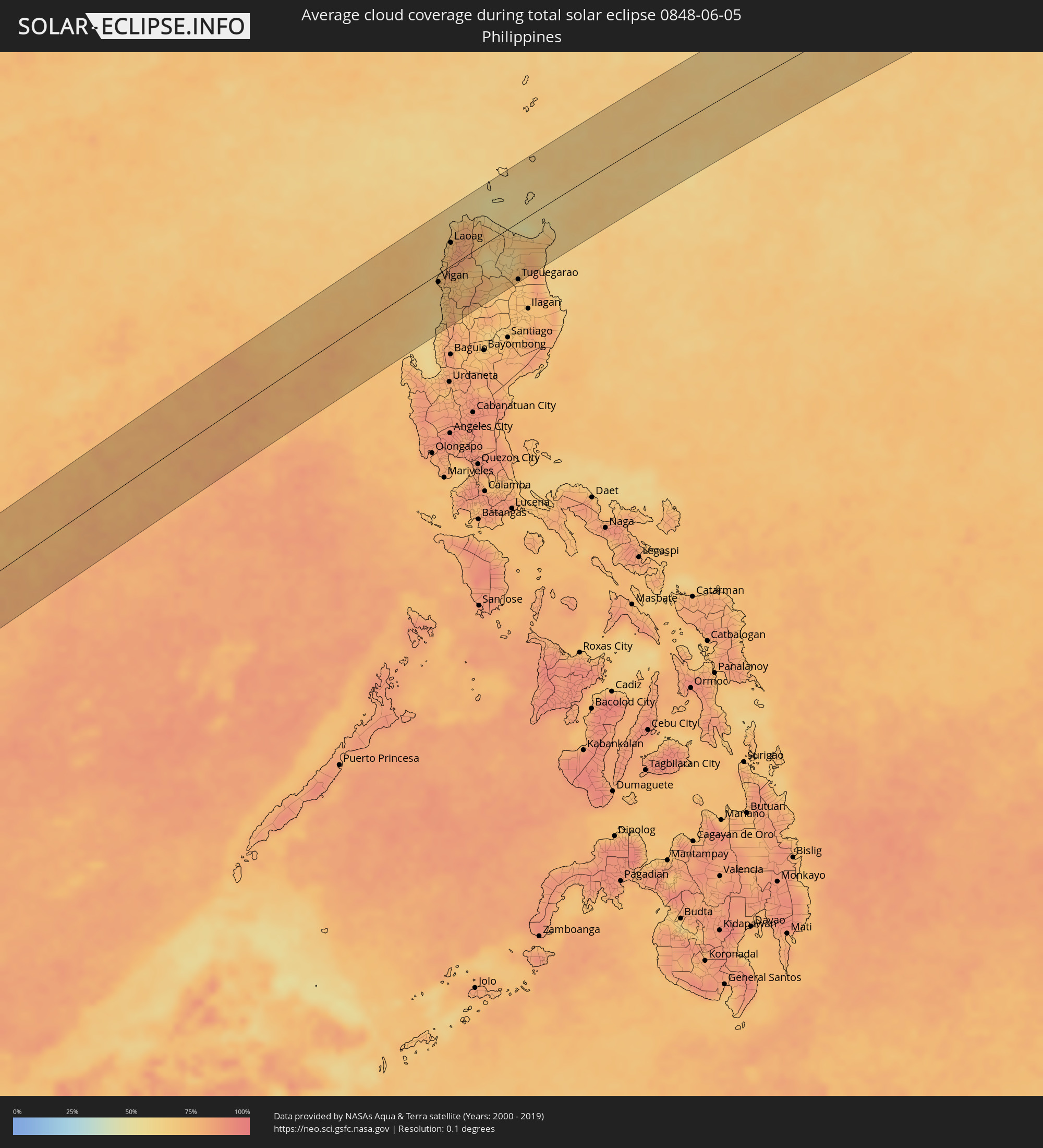 Philippines
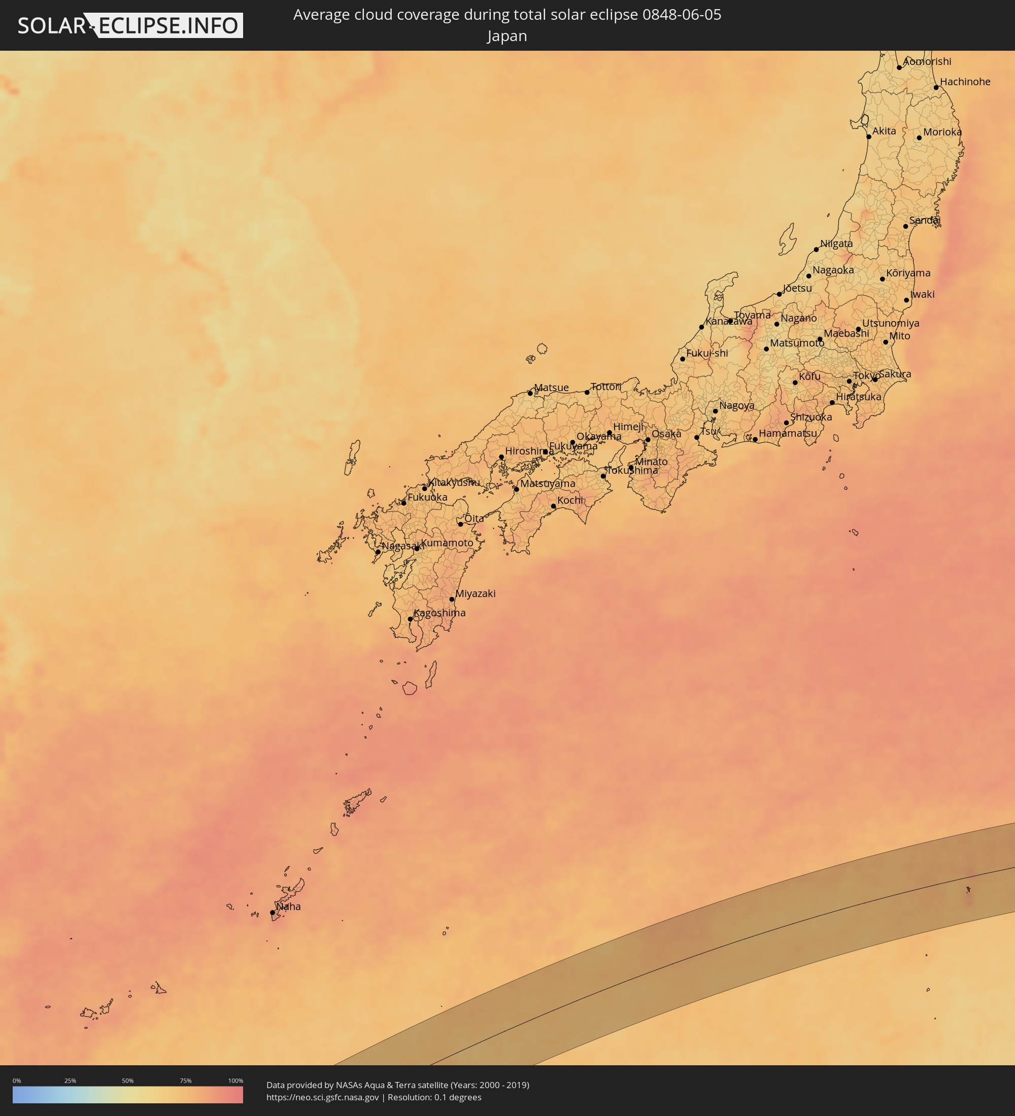 Japan
Japan
Cities inside the path of the eclipse
The following table shows all locations with a population of more than 5,000 inside the eclipse path. Cities which have more than 100,000 inhabitants are marked bold. A click at the locations opens a detailed map.
| City | Type | Eclipse duration | Local time of max. eclipse | Distance to central line | Ø Cloud coverage |
|
Sinabang, Aceh
|
total | - | 08:17:34 UTC+07:07 | 41 km | 83% |
|
Singkil, Aceh
|
total | - | 08:18:09 UTC+07:07 | 59 km | 70% |
|
Pangkalan Brandan, North Sumatra
|
total | - | 08:20:01 UTC+07:07 | 78 km | 86% |
|
Tanjungtiram, North Sumatra
|
total | - | 08:20:07 UTC+07:07 | 76 km | 80% |
|
Stabat, North Sumatra
|
total | - | 08:19:51 UTC+07:07 | 40 km | 89% |
|
Binjai, North Sumatra
|
total | - | 08:19:45 UTC+07:07 | 25 km | 87% |
|
Kabanjahe, North Sumatra
|
total | - | 08:19:17 UTC+07:07 | 22 km | 79% |
|
Berastagi, North Sumatra
|
total | - | 08:19:23 UTC+07:07 | 14 km | 83% |
|
Tongging, North Sumatra
|
total | - | 08:19:07 UTC+07:07 | 43 km | 81% |
|
Sunggal, North Sumatra
|
total | - | 08:19:48 UTC+07:07 | 15 km | 91% |
|
Medan, North Sumatra
|
total | - | 08:19:50 UTC+07:07 | 13 km | 92% |
|
Labuhan Deli, North Sumatra
|
total | - | 08:19:59 UTC+07:07 | 26 km | 92% |
|
Belawan, North Sumatra
|
total | - | 08:20:02 UTC+07:07 | 30 km | 83% |
|
Deli Tua, North Sumatra
|
total | - | 08:19:47 UTC+07:07 | 5 km | 87% |
|
Percut, North Sumatra
|
total | - | 08:20:00 UTC+07:07 | 6 km | 88% |
|
Perbaungan, North Sumatra
|
total | - | 08:20:00 UTC+07:07 | 5 km | 85% |
|
Pematangsiantar, North Sumatra
|
total | - | 08:19:30 UTC+07:07 | 69 km | 86% |
|
Tebingtinggi, North Sumatra
|
total | - | 08:19:55 UTC+07:07 | 40 km | 84% |
|
Pekan Bahapal, North Sumatra
|
total | - | 08:19:43 UTC+07:07 | 61 km | 84% |
|
Juru, Penang
|
total | - | 08:10:55 UTC+06:55 | 71 km | 84% |
|
Bukit Mertajam, Penang
|
total | - | 08:10:59 UTC+06:55 | 74 km | 94% |
|
Nibong Tebal, Penang
|
total | - | 08:10:48 UTC+06:55 | 55 km | 90% |
|
Parit Buntar, Perak
|
total | - | 08:10:46 UTC+06:55 | 51 km | 86% |
|
Bagan Serai, Perak
|
total | - | 08:10:41 UTC+06:55 | 37 km | 78% |
|
Kulim, Kedah
|
total | - | 08:11:04 UTC+06:55 | 69 km | 90% |
|
Pantai Remis, Perak
|
total | - | 08:10:11 UTC+06:55 | 20 km | 75% |
|
Lumut, Perak
|
total | - | 08:09:58 UTC+06:55 | 41 km | 71% |
|
Simpang Empat, Perak
|
total | - | 08:10:41 UTC+06:55 | 26 km | 81% |
|
Taiping, Perak
|
total | - | 08:10:39 UTC+06:55 | 10 km | 86% |
|
Kuala Kangsar, Perak
|
total | - | 08:10:43 UTC+06:55 | 9 km | 81% |
|
Batu Gajah, Perak
|
total | - | 08:10:30 UTC+06:55 | 44 km | 77% |
|
Betong, Yala
|
total | - | 07:58:30 UTC+06:42 | 77 km | 81% |
|
Ipoh, Perak
|
total | - | 08:10:38 UTC+06:55 | 35 km | 87% |
|
Kampar, Perak
|
total | - | 08:10:24 UTC+06:55 | 66 km | 78% |
|
Tanah Rata, Pahang
|
total | - | 08:10:44 UTC+06:55 | 64 km | 85% |
|
Ban Su-ngai Pa Di, Narathiwat
|
total | - | 07:59:25 UTC+06:42 | 57 km | 79% |
|
Gua Musang, Kelantan
|
total | - | 08:11:36 UTC+06:55 | 60 km | 77% |
|
Su-ngai Kolok, Narathiwat
|
total | - | 07:59:27 UTC+06:42 | 47 km | 75% |
|
Tak Bai, Narathiwat
|
total | - | 07:59:46 UTC+06:42 | 63 km | 76% |
|
Pasir Mas, Kelantan
|
total | - | 08:12:57 UTC+06:55 | 38 km | 77% |
|
Tanah Merah, Kelantan
|
total | - | 08:12:42 UTC+06:55 | 15 km | 80% |
|
Tumpat, Kelantan
|
total | - | 08:13:08 UTC+06:55 | 50 km | 84% |
|
Kampong Pangkal Kalong, Kelantan
|
total | - | 08:12:52 UTC+06:55 | 21 km | 77% |
|
Kota Bharu, Kelantan
|
total | - | 08:13:07 UTC+06:55 | 40 km | 85% |
|
Kampong Kadok, Kelantan
|
total | - | 08:12:59 UTC+06:55 | 27 km | 89% |
|
Peringat, Kelantan
|
total | - | 08:13:03 UTC+06:55 | 28 km | 89% |
|
Jertih, Terengganu
|
total | - | 08:12:54 UTC+06:55 | 12 km | 84% |
|
Vigan, Ilocos
|
total | - | 09:56:55 UTC+08:00 | 12 km | 69% |
|
Bantay, Ilocos
|
total | - | 09:56:56 UTC+08:00 | 11 km | 69% |
|
Rimus, Ilocos
|
total | - | 09:55:53 UTC+08:00 | 78 km | 69% |
|
Bangar, Ilocos
|
total | - | 09:55:58 UTC+08:00 | 78 km | 69% |
|
Tagudin, Ilocos
|
total | - | 09:56:04 UTC+08:00 | 75 km | 69% |
|
Santa Maria, Ilocos
|
total | - | 09:56:06 UTC+08:00 | 74 km | 64% |
|
Candon, Ilocos
|
total | - | 09:56:28 UTC+08:00 | 51 km | 73% |
|
Cabugao, Ilocos
|
total | - | 09:57:23 UTC+08:00 | 4 km | 79% |
|
Suyo, Ilocos
|
total | - | 09:56:17 UTC+08:00 | 76 km | 75% |
|
Batac City, Ilocos
|
total | - | 09:57:59 UTC+08:00 | 23 km | 78% |
|
San Nicolas, Ilocos
|
total | - | 09:58:13 UTC+08:00 | 32 km | 75% |
|
Laoag, Ilocos
|
total | - | 09:58:15 UTC+08:00 | 34 km | 75% |
|
Bacarra, Ilocos
|
total | - | 09:58:22 UTC+08:00 | 38 km | 74% |
|
Pasuquin, Ilocos
|
total | - | 09:58:30 UTC+08:00 | 45 km | 74% |
|
Sarrat, Ilocos
|
total | - | 09:58:18 UTC+08:00 | 27 km | 75% |
|
Vintar, Ilocos
|
total | - | 09:58:24 UTC+08:00 | 34 km | 75% |
|
Dingras, Ilocos
|
total | - | 09:58:18 UTC+08:00 | 19 km | 85% |
|
Claveria, Cagayan Valley
|
total | - | 09:59:49 UTC+08:00 | 45 km | 65% |
|
Pasil, Cordillera
|
total | - | 09:58:04 UTC+08:00 | 73 km | 74% |
|
Tabuk, Cordillera
|
total | - | 09:58:51 UTC+08:00 | 84 km | 73% |
|
Piat, Cagayan Valley
|
total | - | 09:59:21 UTC+08:00 | 55 km | 68% |
|
Cabaritan East, Cagayan Valley
|
total | - | 10:00:19 UTC+08:00 | 4 km | 67% |
|
Ballesteros, Cagayan Valley
|
total | - | 10:00:22 UTC+08:00 | 2 km | 67% |
|
Lasam, Cagayan Valley
|
total | - | 10:00:00 UTC+08:00 | 36 km | 64% |
|
Aparri, Cagayan Valley
|
total | - | 10:00:32 UTC+08:00 | 11 km | 64% |
|
Magapit, Cagayan Valley
|
total | - | 10:00:15 UTC+08:00 | 33 km | 67% |
|
Magapit, Aguiguican, Cagayan Valley
|
total | - | 10:00:13 UTC+08:00 | 36 km | 67% |
|
Bauan, Cagayan Valley
|
total | - | 09:59:39 UTC+08:00 | 72 km | 72% |
|
Solana, Cagayan Valley
|
total | - | 09:59:34 UTC+08:00 | 80 km | 72% |
|
Atulayan, Cagayan Valley
|
total | - | 09:59:35 UTC+08:00 | 79 km | 72% |
|
Enrile, Cagayan Valley
|
total | - | 09:59:26 UTC+08:00 | 89 km | 70% |
|
Nattapian, Cagayan Valley
|
total | - | 09:59:37 UTC+08:00 | 78 km | 72% |
|
Dassun, Cagayan Valley
|
total | - | 09:59:45 UTC+08:00 | 72 km | 72% |
|
Tuguegarao, Cagayan Valley
|
total | - | 09:59:34 UTC+08:00 | 85 km | 70% |
|
Gonzaga, Cagayan Valley
|
total | - | 10:01:05 UTC+08:00 | 40 km | 68% |
|
Santa Ana, Cagayan Valley
|
total | - | 10:01:42 UTC+08:00 | 29 km | 61% |