Total solar eclipse of 05/12/2822
| Day of week: | Thursday |
| Maximum duration of eclipse: | 05m34s |
| Maximum width of eclipse path: | 278 km |
| Saros cycle: | 151 |
| Coverage: | 100% |
| Magnitude: | 1.065 |
| Gamma: | -0.6549 |
Wo kann man die Sonnenfinsternis vom 05/12/2822 sehen?
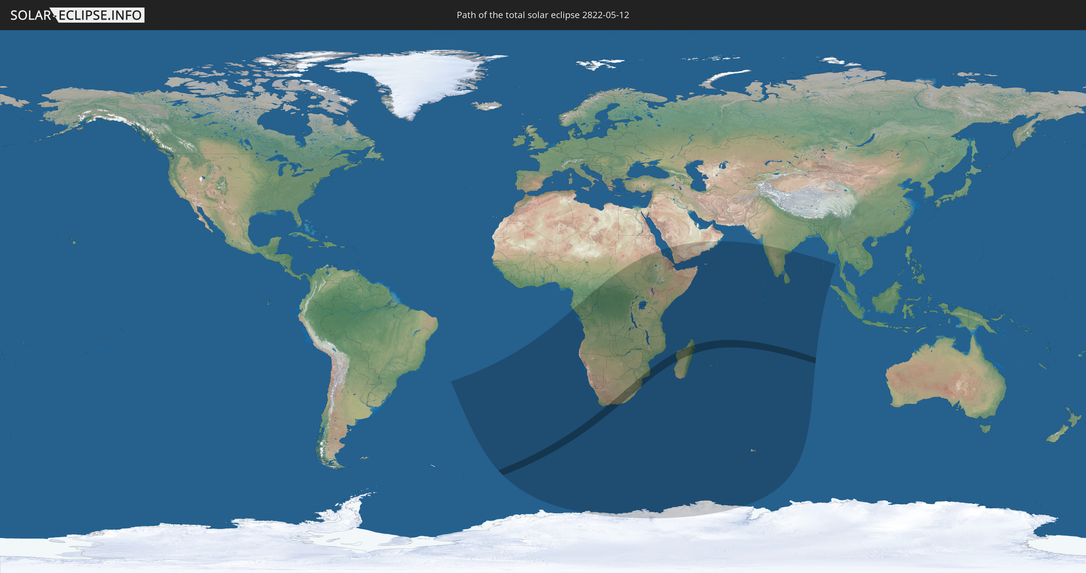
Die Sonnenfinsternis am 05/12/2822 kann man in 43 Ländern als partielle Sonnenfinsternis beobachten.
Der Finsternispfad verläuft durch 6 Länder. Nur in diesen Ländern ist sie als total Sonnenfinsternis zu sehen.
In den folgenden Ländern ist die Sonnenfinsternis total zu sehen
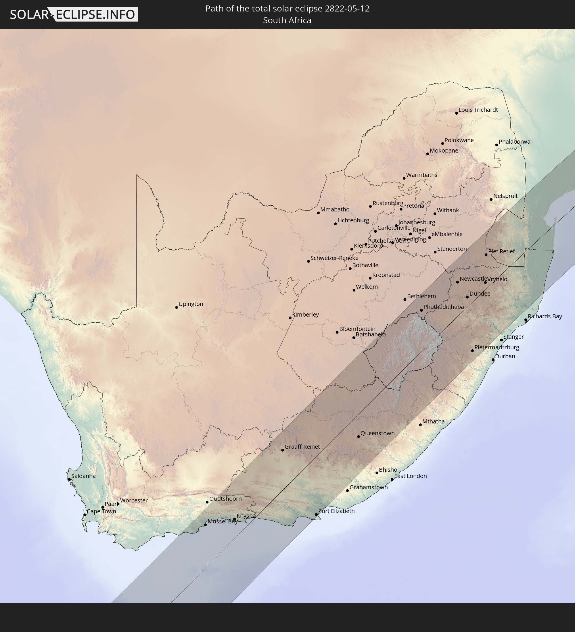 South Africa
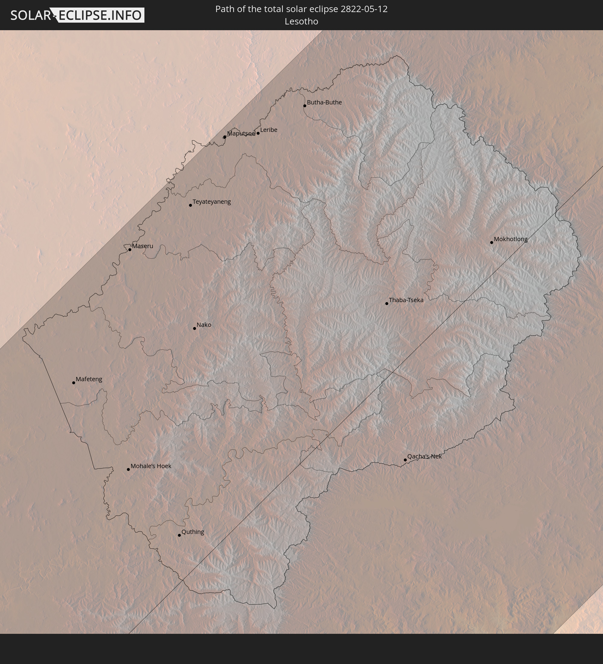 Lesotho
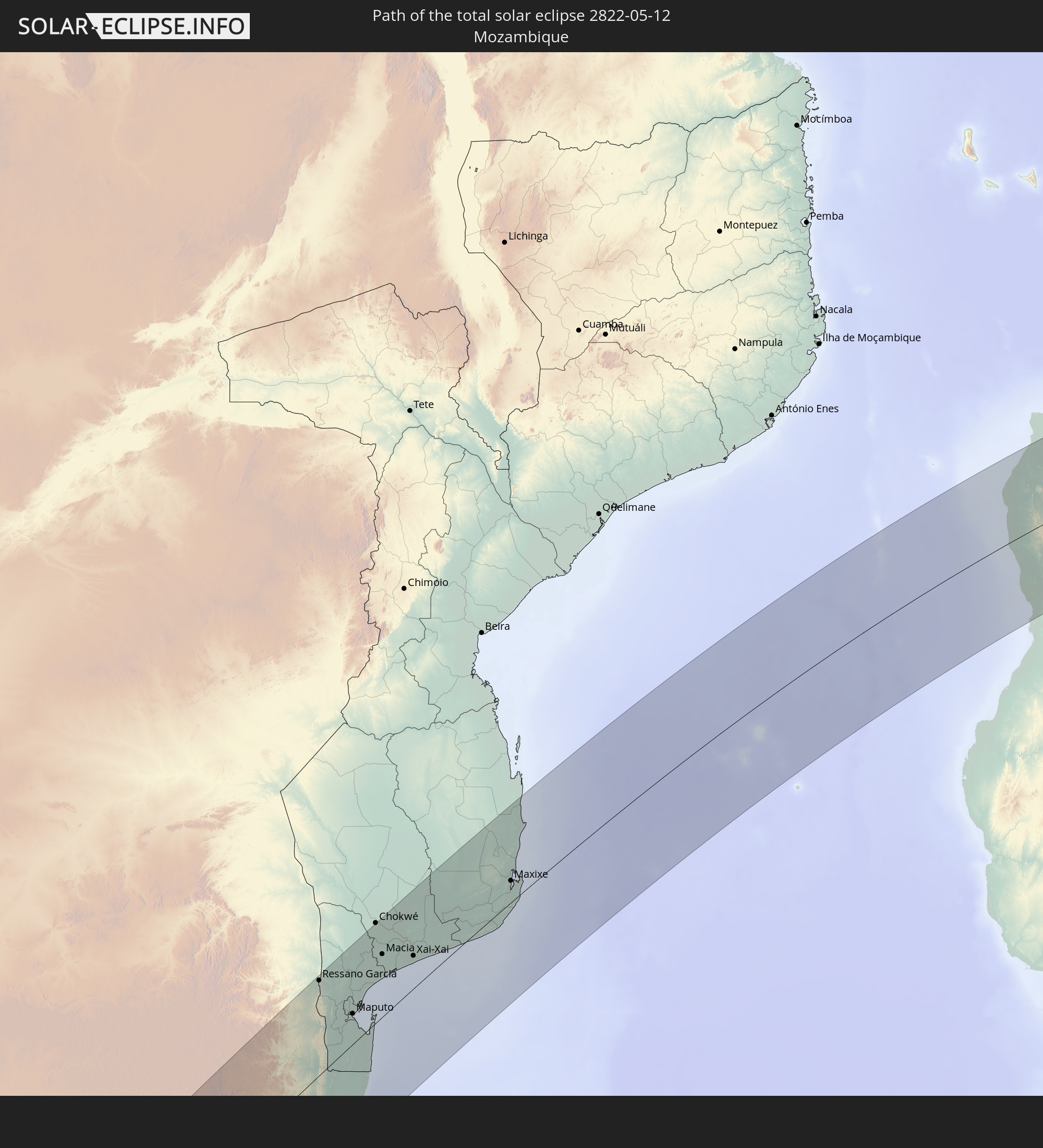 Mozambique
 Swaziland
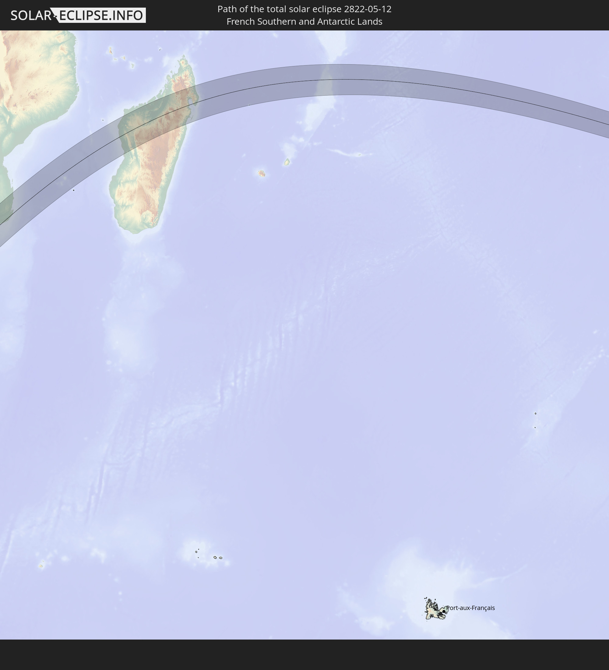 French Southern and Antarctic Lands
 Madagascar
In den folgenden Ländern ist die Sonnenfinsternis partiell zu sehen
 Antarctica
 Saint Helena, Ascension and Tristan da Cunha
 Bouvet Island
 Cameroon
 Gabon
Gabon
 Republic of the Congo
 Angola
 Namibia
 Democratic Republic of the Congo
 Central African Republic
 South Africa
 Botswana
 Sudan
Sudan
 Zambia
 Zimbabwe
 Lesotho
 Rwanda
 Burundi
 Tanzania
 Uganda
 Mozambique
 Swaziland
 Malawi
 Ethiopia
 Kenya
Kenya
 Saudi Arabia
 Eritrea
 French Southern and Antarctic Lands
 Somalia
 Djibouti
 Yemen
Yemen
 Madagascar
 Comoros
 Mayotte
 Seychelles
 Oman
Oman
 Réunion
 Mauritius
 India
India
 British Indian Ocean Territory
 Heard Island and McDonald Islands
 Maldives
 Sri Lanka
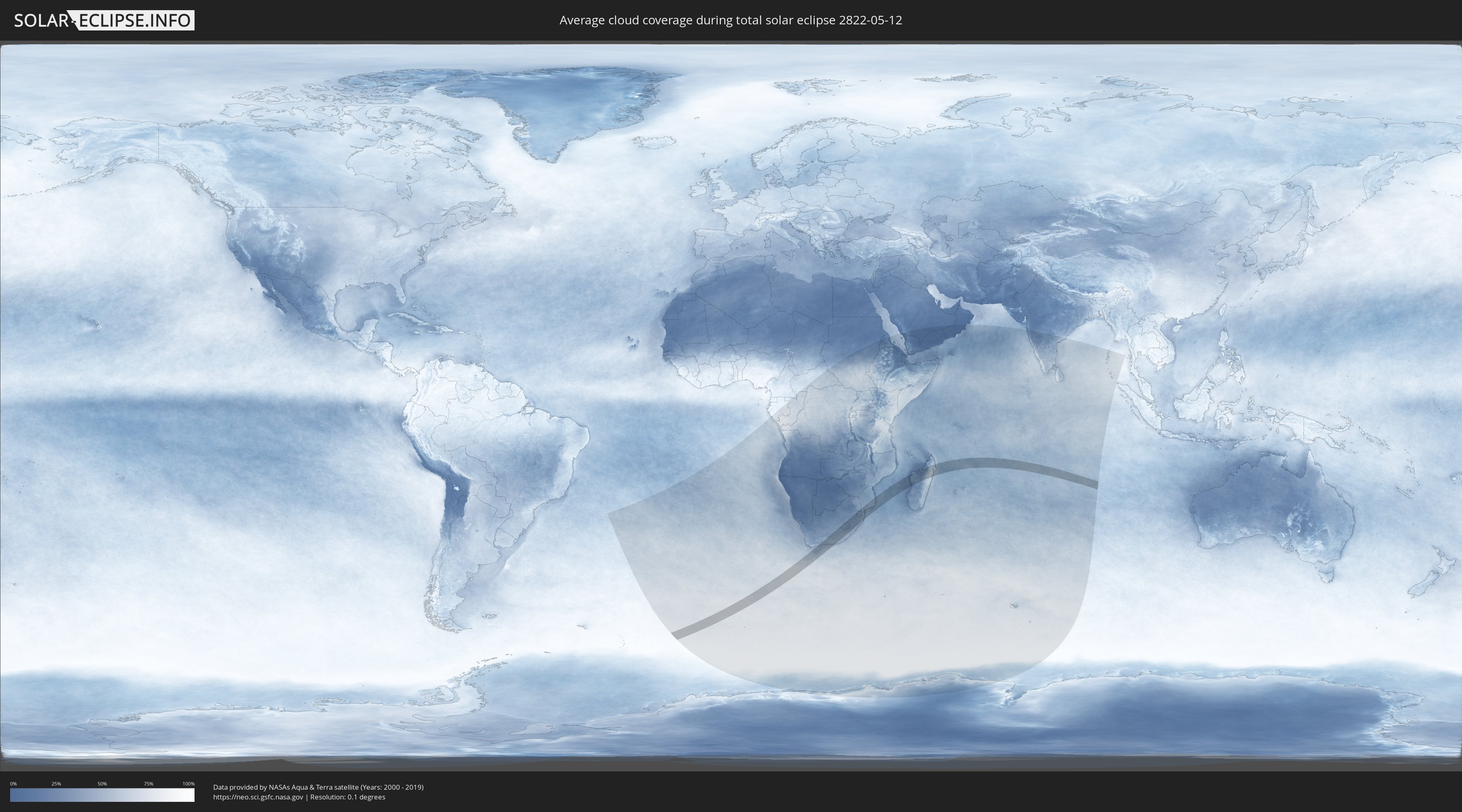
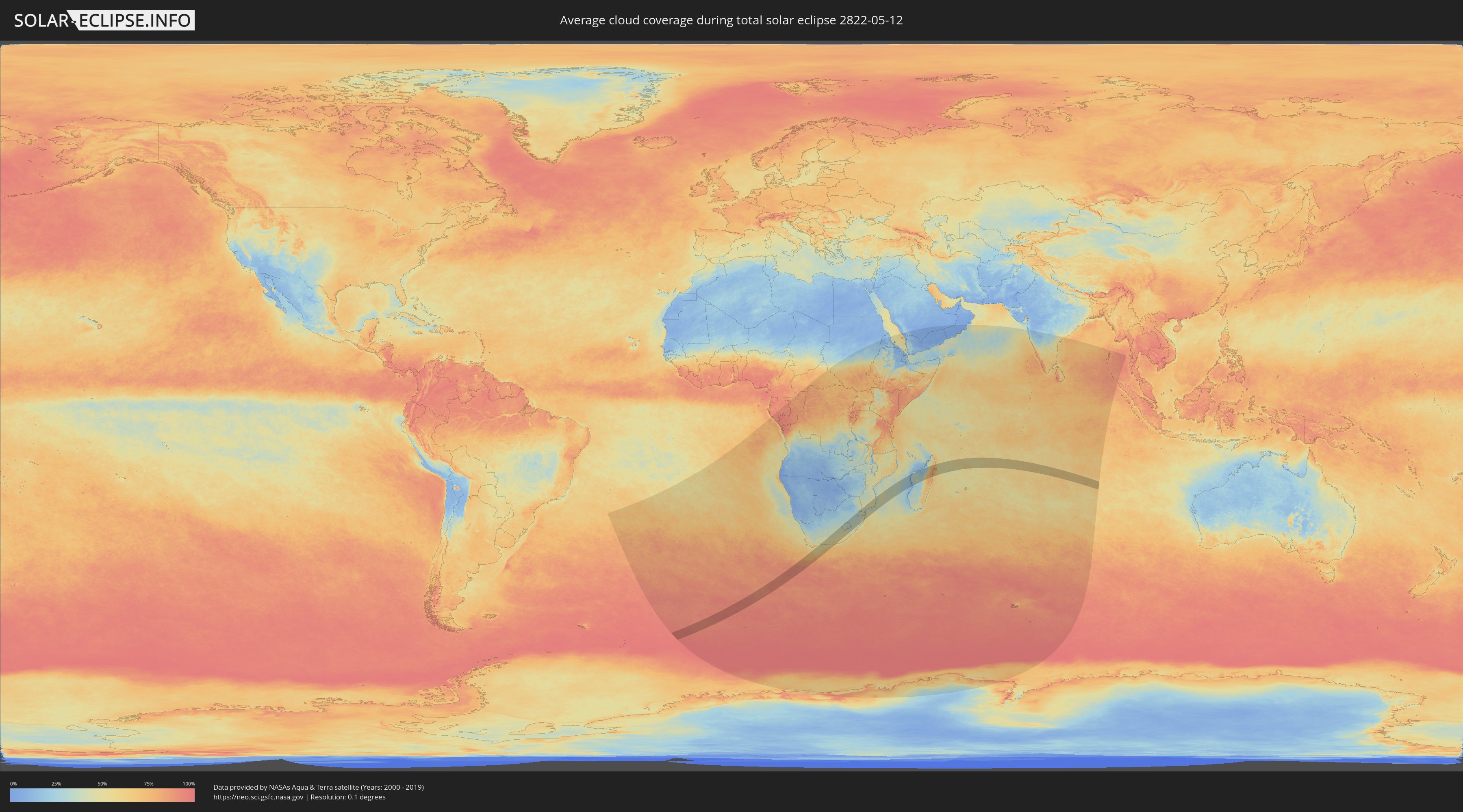
How will be the weather during the total solar eclipse on 05/12/2822?
Where is the best place to see the total solar eclipse of 05/12/2822?
The following maps show the average cloud coverage for the day of the total solar eclipse.
With the help of these maps, it is possible to find the place along the eclipse path, which has the best
chance of a cloudless sky.
Nevertheless, you should consider local circumstances and inform about the weather of your chosen
observation site.
The data is provided by NASAs satellites
AQUA and TERRA.
The cloud maps are averaged over a period of 19 years (2000 - 2019).
Detailed country maps
 South Africa
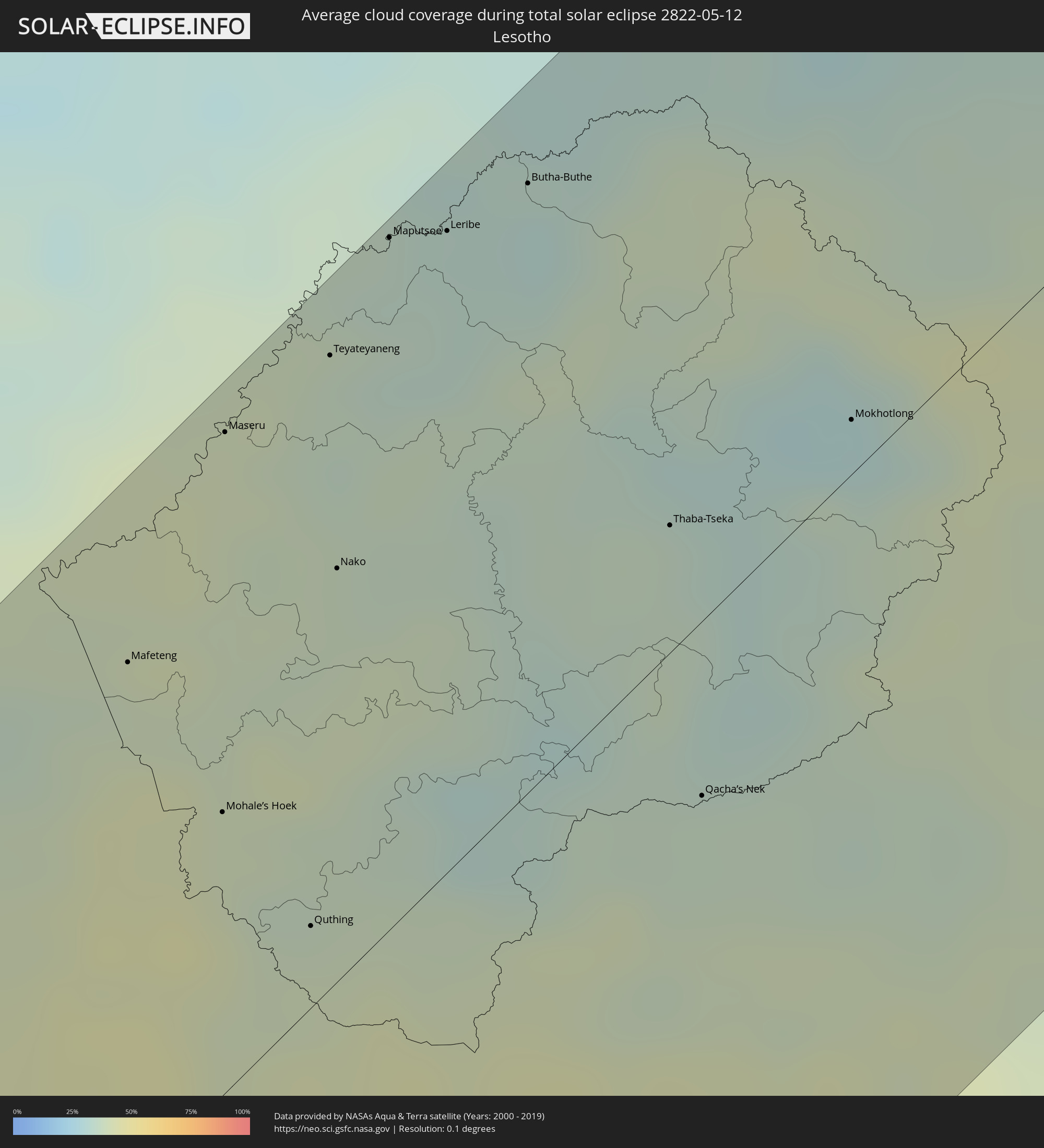 Lesotho
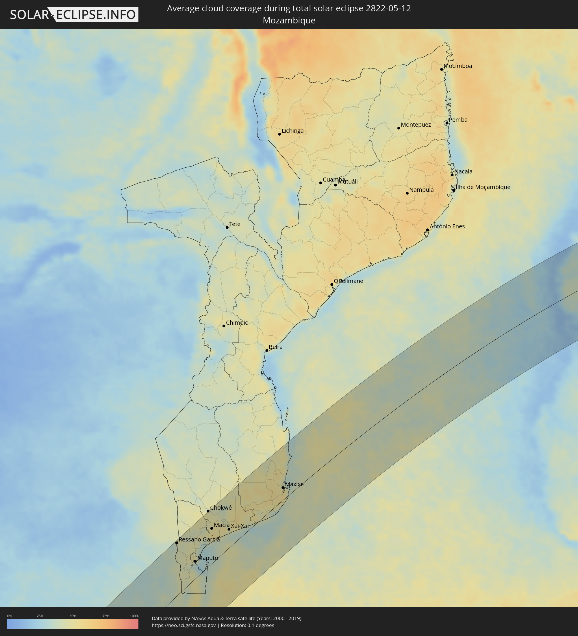 Mozambique
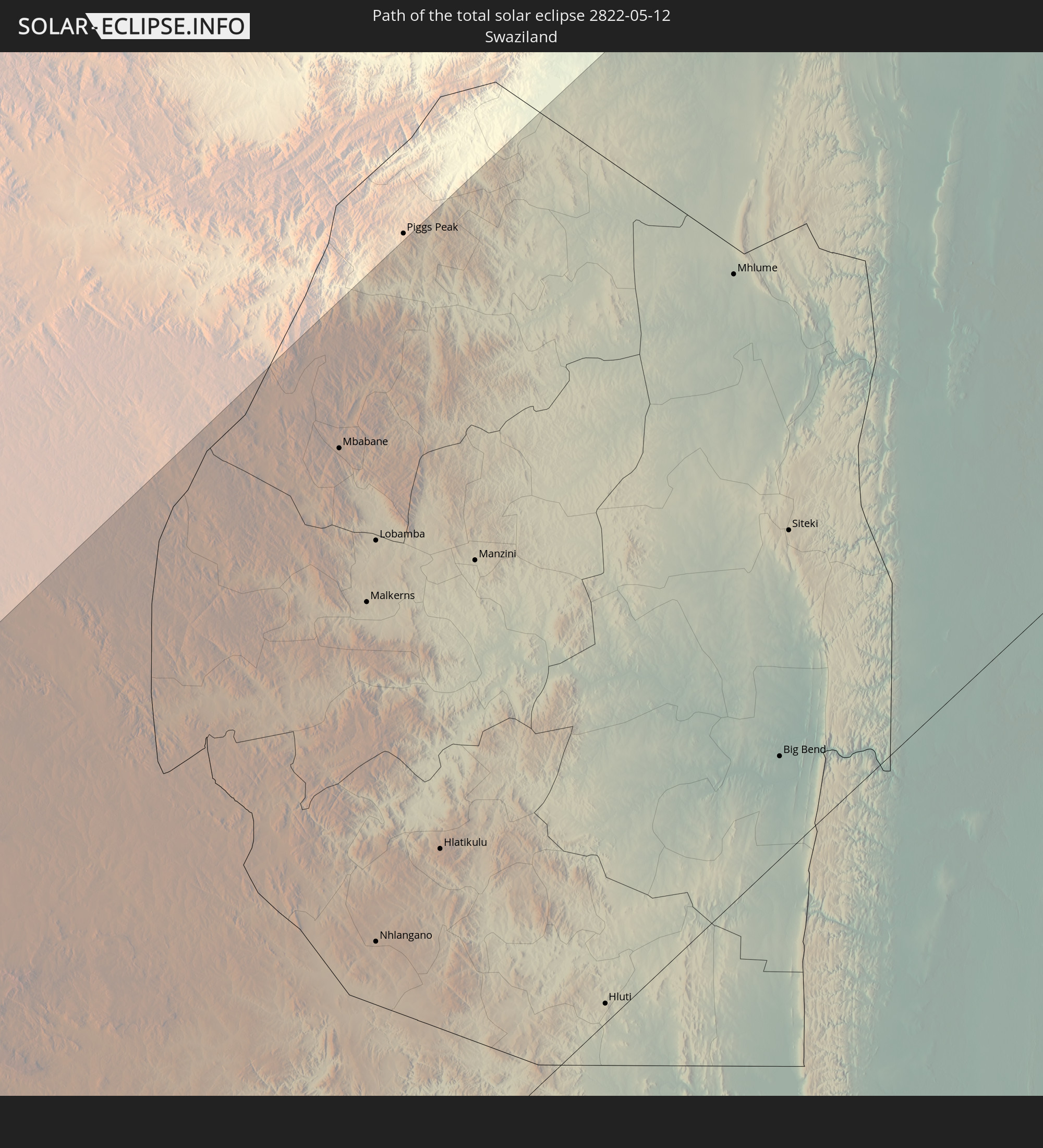
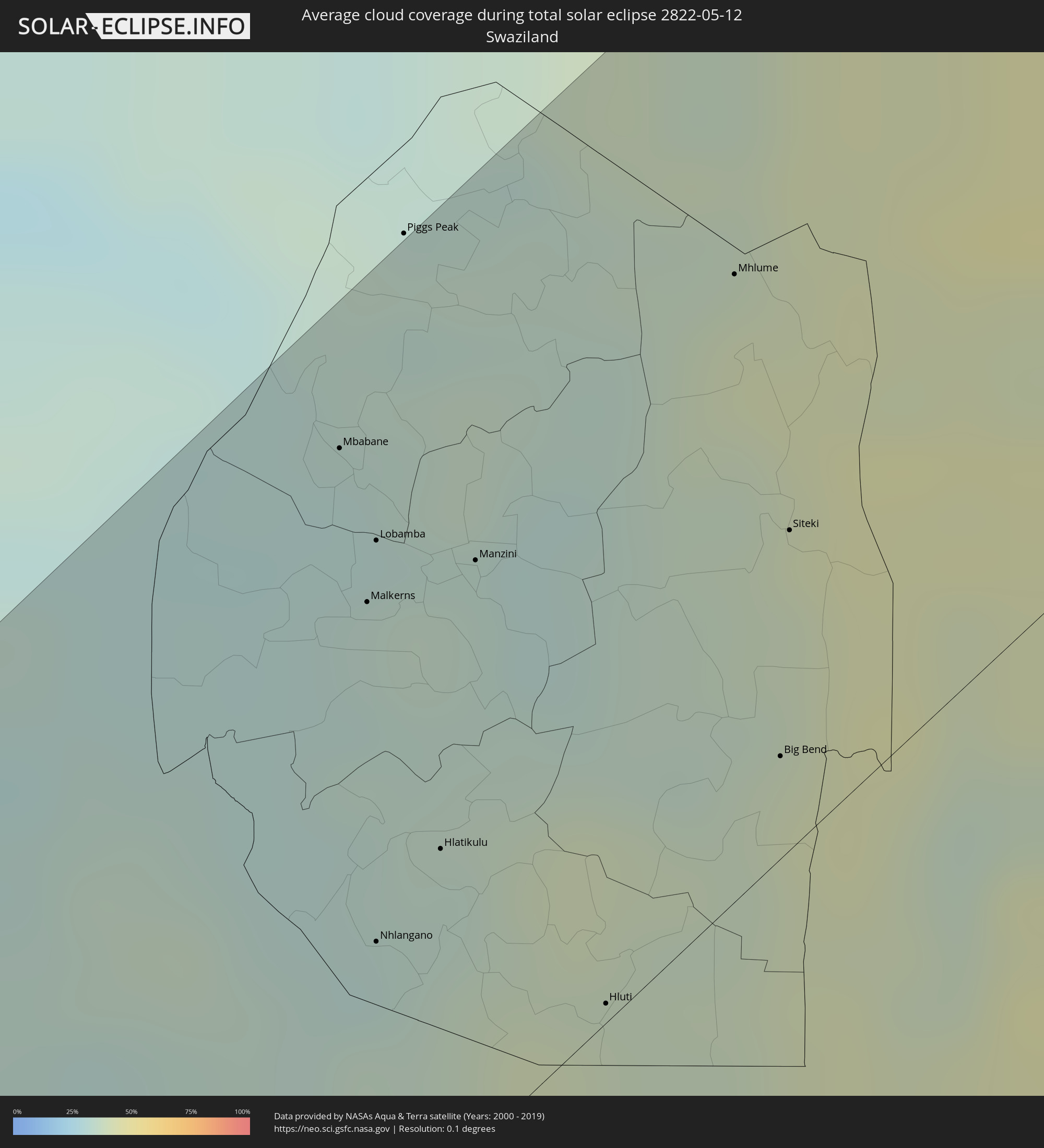 Swaziland
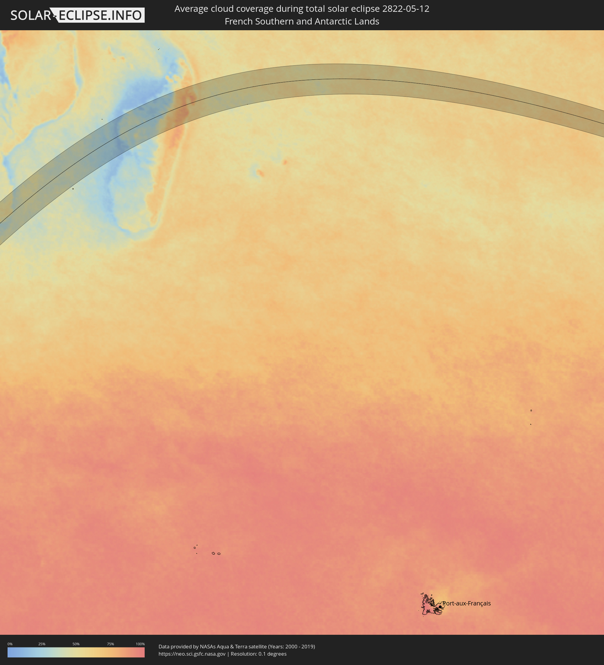 French Southern and Antarctic Lands
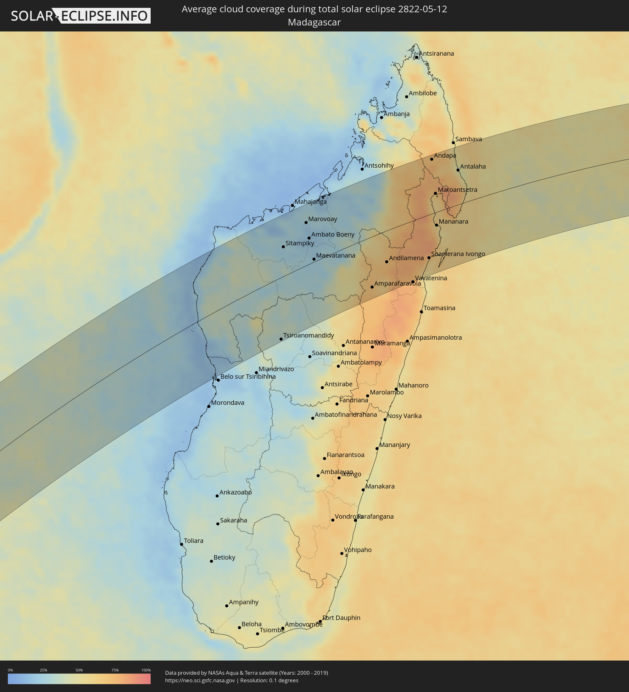 Madagascar
Cities inside the path of the eclipse
The following table shows all locations with a population of more than 5,000 inside the eclipse path. Cities which have more than 100,000 inhabitants are marked bold. A click at the locations opens a detailed map.
| City | Type | Eclipse duration | Local time of max. eclipse | Distance to central line | Ø Cloud coverage |
|
Mossel Bay, Western Cape
|
total | - | 11:20:14 UTC+02:00 | 85 km | 50% |
|
George, Western Cape
|
total | - | 11:20:51 UTC+02:00 | 82 km | 49% |
|
Knysna, Western Cape
|
total | - | 11:21:46 UTC+02:00 | 38 km | 44% |
|
Plettenberg Bay, Western Cape
|
total | - | 11:22:17 UTC+02:00 | 15 km | 49% |
|
Graaff-Reinet, Eastern Cape
|
total | - | 11:25:20 UTC+02:00 | 80 km | 45% |
|
Kruisfontein, Eastern Cape
|
total | - | 11:24:34 UTC+02:00 | 70 km | 52% |
|
Middelburg, Eastern Cape
|
total | - | 11:26:40 UTC+02:00 | 109 km | 40% |
|
Uitenhage, Eastern Cape
|
total | - | 11:25:51 UTC+02:00 | 95 km | 57% |
|
Port Elizabeth, Eastern Cape
|
total | - | 11:26:02 UTC+02:00 | 119 km | 57% |
|
Somerset East, Eastern Cape
|
total | - | 11:26:50 UTC+02:00 | 27 km | 48% |
|
Cradock, Eastern Cape
|
total | - | 11:27:17 UTC+02:00 | 15 km | 45% |
|
Adelaide, Eastern Cape
|
total | - | 11:28:05 UTC+02:00 | 73 km | 52% |
|
Burgersdorp, Eastern Cape
|
total | - | 11:29:23 UTC+02:00 | 59 km | 42% |
|
Fort Beaufort, Eastern Cape
|
total | - | 11:28:38 UTC+02:00 | 101 km | 51% |
|
Aliwal North, Eastern Cape
|
total | - | 11:30:19 UTC+02:00 | 58 km | 43% |
|
Whittlesea, Eastern Cape
|
total | - | 11:29:24 UTC+02:00 | 67 km | 51% |
|
Queenstown, Eastern Cape
|
total | - | 11:29:42 UTC+02:00 | 48 km | 49% |
|
Queensdale, Eastern Cape
|
total | - | 11:29:54 UTC+02:00 | 53 km | 49% |
|
Zastron, Orange Free State
|
total | - | 11:31:19 UTC+02:00 | 63 km | 42% |
|
Lady Frere, Eastern Cape
|
total | - | 11:30:29 UTC+02:00 | 57 km | 50% |
|
Mafeteng, Mafeteng
|
total | - | 11:31:59 UTC+02:00 | 91 km | 38% |
|
Mohale’s Hoek, Mohaleʼs Hoek
|
total | - | 11:32:10 UTC+02:00 | 49 km | 41% |
|
Maseru, Maseru
|
total | - | 11:32:53 UTC+02:00 | 115 km | 40% |
|
Quthing, Quthing
|
total | - | 11:32:22 UTC+02:00 | 14 km | 40% |
|
Teyateyaneng, Berea
|
total | - | 11:33:32 UTC+02:00 | 110 km | 38% |
|
Nako, Maseru
|
total | - | 11:33:09 UTC+02:00 | 72 km | 37% |
|
Maputsoe, Leribe
|
total | - | 11:34:02 UTC+02:00 | 121 km | 34% |
|
Leribe, Leribe
|
total | - | 11:34:20 UTC+02:00 | 112 km | 34% |
|
Butha-Buthe, Butha-Buthe
|
total | - | 11:34:49 UTC+02:00 | 107 km | 32% |
|
Thaba-Tseka, Thaba-Tseka
|
total | - | 11:34:50 UTC+02:00 | 22 km | 36% |
|
Qacha’s Nek, Qachaʼs Nek
|
total | - | 11:34:28 UTC+02:00 | 30 km | 36% |
|
Phuthaditjhaba, Orange Free State
|
total | - | 11:36:08 UTC+02:00 | 88 km | 33% |
|
Mokhotlong, Mokhotlong
|
total | - | 11:35:55 UTC+02:00 | 10 km | 31% |
|
Harrismith, Orange Free State
|
total | - | 11:36:59 UTC+02:00 | 87 km | 32% |
|
Kokstad, KwaZulu-Natal
|
total | - | 11:35:30 UTC+02:00 | 114 km | 40% |
|
Volksrust, Mpumalanga
|
total | - | 11:39:20 UTC+02:00 | 108 km | 32% |
|
Newcastle, KwaZulu-Natal
|
total | - | 11:39:03 UTC+02:00 | 73 km | 35% |
|
Glencoe, KwaZulu-Natal
|
total | - | 11:39:04 UTC+02:00 | 25 km | 34% |
|
Ekuvukeni, KwaZulu-Natal
|
total | - | 11:38:49 UTC+02:00 | 1 km | 32% |
|
Mpophomeni, KwaZulu-Natal
|
total | - | 11:37:51 UTC+02:00 | 89 km | 40% |
|
Howick, KwaZulu-Natal
|
total | - | 11:38:01 UTC+02:00 | 84 km | 38% |
|
Dundee, KwaZulu-Natal
|
total | - | 11:39:15 UTC+02:00 | 20 km | 35% |
|
Richmond, KwaZulu-Natal
|
total | - | 11:37:44 UTC+02:00 | 119 km | 40% |
|
Pietermaritzburg, KwaZulu-Natal
|
total | - | 11:38:13 UTC+02:00 | 106 km | 42% |
|
Driefontein, Mpumalanga
|
total | - | 11:40:50 UTC+02:00 | 98 km | 32% |
|
Greytown, KwaZulu-Natal
|
total | - | 11:39:07 UTC+02:00 | 76 km | 38% |
|
Mondlo, KwaZulu-Natal
|
total | - | 11:40:24 UTC+02:00 | 2 km | 34% |
|
Vryheid, KwaZulu-Natal
|
total | - | 11:40:46 UTC+02:00 | 14 km | 34% |
|
Piet Retief, Mpumalanga
|
total | - | 11:41:35 UTC+02:00 | 74 km | 36% |
|
Mbabane, Hhohho
|
total | - | 11:42:58 UTC+02:00 | 108 km | 30% |
|
Malkerns, Manzini
|
total | - | 11:42:48 UTC+02:00 | 85 km | 32% |
|
Nhlangano, Shiselweni
|
total | - | 11:42:16 UTC+02:00 | 39 km | 32% |
|
Lobamba, Hhohho
|
total | - | 11:42:56 UTC+02:00 | 92 km | 33% |
|
Hlatikulu, Shiselweni
|
total | - | 11:42:39 UTC+02:00 | 43 km | 33% |
|
Manzini, Manzini
|
total | - | 11:43:17 UTC+02:00 | 77 km | 34% |
|
Ulundi, KwaZulu-Natal
|
total | - | 11:41:28 UTC+02:00 | 74 km | 36% |
|
Eshowe, KwaZulu-Natal
|
total | - | 11:41:03 UTC+02:00 | 122 km | 44% |
|
Hluti, Shiselweni
|
total | - | 11:43:01 UTC+02:00 | 3 km | 39% |
|
Mhlume, Lubombo
|
total | - | 11:44:45 UTC+02:00 | 83 km | 41% |
|
Big Bend, Lubombo
|
total | - | 11:44:05 UTC+02:00 | 13 km | 38% |
|
Siteki, Lubombo
|
total | - | 11:44:31 UTC+02:00 | 42 km | 39% |
|
Komatipoort, Mpumalanga
|
total | - | 11:45:38 UTC+02:00 | 125 km | 38% |
|
Ressano Garcia, Maputo
|
total | - | 11:45:42 UTC+02:00 | 122 km | 38% |
|
Matola, Maputo
|
total | - | 11:46:07 UTC+02:00 | 48 km | 36% |
|
Maputo, Maputo City
|
total | - | 11:46:22 UTC+02:00 | 39 km | 33% |
|
Chokwé, Gaza
|
total | - | 11:48:51 UTC+02:00 | 130 km | 45% |
|
Macia, Gaza
|
total | - | 11:48:31 UTC+02:00 | 82 km | 51% |
|
Chibuto, Gaza
|
total | - | 11:49:51 UTC+02:00 | 81 km | 43% |
|
Xai-Xai, Gaza
|
total | - | 11:49:40 UTC+02:00 | 43 km | 41% |
|
Manjacaze, Gaza
|
total | - | 11:50:35 UTC+02:00 | 55 km | 53% |
|
Maxixe, Inhambane
|
total | - | 11:54:50 UTC+02:00 | 29 km | 52% |
|
Inhambane, Inhambane
|
total | - | 11:54:55 UTC+02:00 | 26 km | 52% |
|
Maintirano, Melaky
|
total | - | 13:23:03 UTC+03:00 | 30 km | 15% |
|
Mahabe, Melaky
|
total | - | 13:27:35 UTC+03:00 | 61 km | 38% |
|
Tsiroanomandidy, Bongolava
|
total | - | 13:26:53 UTC+03:00 | 140 km | 33% |
|
Sitampiky, Boeny
|
total | - | 13:30:01 UTC+03:00 | 67 km | 24% |
|
Fenoarivo Be, Bongolava
|
total | - | 13:28:36 UTC+03:00 | 132 km | 31% |
|
Marovoay, Boeny
|
total | - | 13:32:07 UTC+03:00 | 99 km | 21% |
|
Ambato Boeny, Boeny
|
total | - | 13:31:46 UTC+03:00 | 59 km | 21% |
|
Maevatanana, Betsiboka
|
total | - | 13:31:22 UTC+03:00 | 5 km | 25% |
|
Tsaratanana, Betsiboka
|
total | - | 13:33:31 UTC+03:00 | 15 km | 37% |
|
Amparafaravola, Alaotra Mangoro
|
total | - | 13:33:45 UTC+03:00 | 119 km | 70% |
|
Bemaitso, Alaotra Mangoro
|
total | - | 13:35:08 UTC+03:00 | 77 km | 73% |
|
Andilamena, Alaotra Mangoro
|
total | - | 13:35:23 UTC+03:00 | 74 km | 73% |
|
Antsirabe Afovoany, Sofia
|
total | - | 13:37:49 UTC+03:00 | 20 km | 70% |
|
Sahatavy, Analanjirofo
|
total | - | 13:35:46 UTC+03:00 | 137 km | 79% |
|
Vohibinany, Atsinanana
|
total | - | 13:35:59 UTC+03:00 | 128 km | 75% |
|
Soanierana Ivongo, Analanjirofo
|
total | - | 13:37:53 UTC+03:00 | 104 km | 59% |
|
Andapa, Sava
|
total | - | 13:41:14 UTC+03:00 | 131 km | 77% |
|
Maroantsetra, Analanjirofo
|
total | - | 13:40:20 UTC+03:00 | 46 km | 64% |
|
Mananara, Analanjirofo
|
total | - | 13:39:22 UTC+03:00 | 32 km | 59% |
|
Antakotako, Analanjirofo
|
total | - | 13:40:39 UTC+03:00 | 56 km | 72% |
|
Ambodifotatra, Analanjirofo
|
total | - | 13:38:24 UTC+03:00 | 121 km | 64% |
|
Ampahana, Sava
|
total | - | 13:42:24 UTC+03:00 | 101 km | 56% |
|
Antalaha, Sava
|
total | - | 13:42:20 UTC+03:00 | 83 km | 52% |