Totale Sonnenfinsternis vom 16.06.-0176
| Wochentag: | Montag |
| Maximale Dauer der Verfinsterung: | 06m23s |
| Maximale Breite des Finsternispfades: | 226 km |
| Saroszyklus: | 63 |
| Bedeckungsgrad: | 100% |
| Magnitude: | 1.0678 |
| Gamma: | -0.2101 |
Wo kann man die Sonnenfinsternis vom 16.06.-0176 sehen?

Die Sonnenfinsternis am 16.06.-0176 kann man in 85 Ländern als partielle Sonnenfinsternis beobachten.
Der Finsternispfad verläuft durch 17 Länder. Nur in diesen Ländern ist sie als totale Sonnenfinsternis zu sehen.
In den folgenden Ländern ist die Sonnenfinsternis total zu sehen
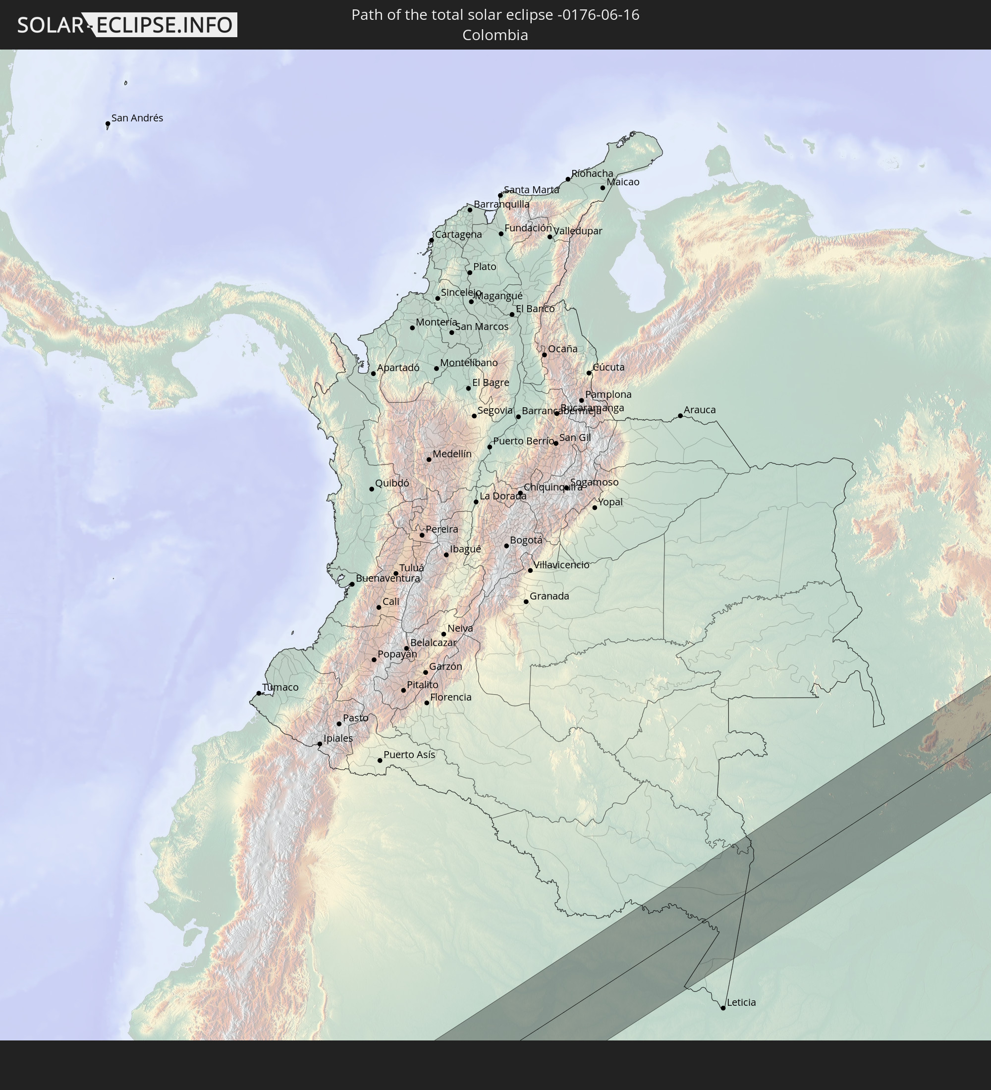 Kolumbien
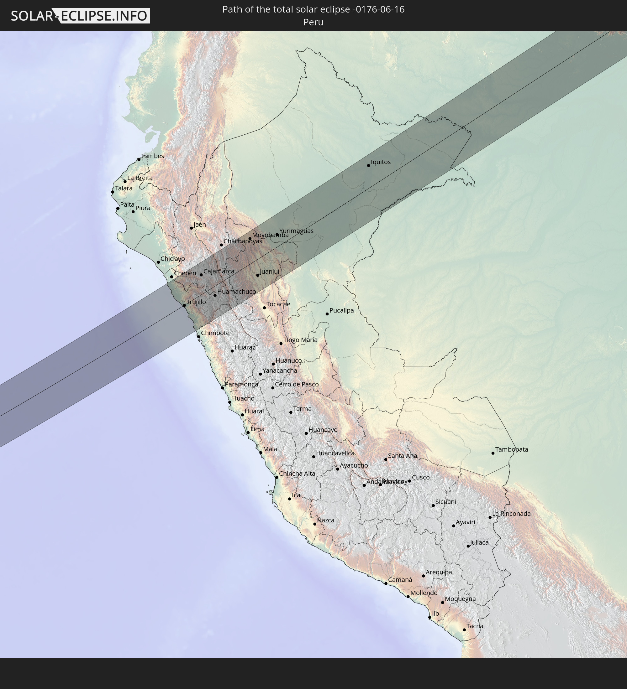 Peru
Peru
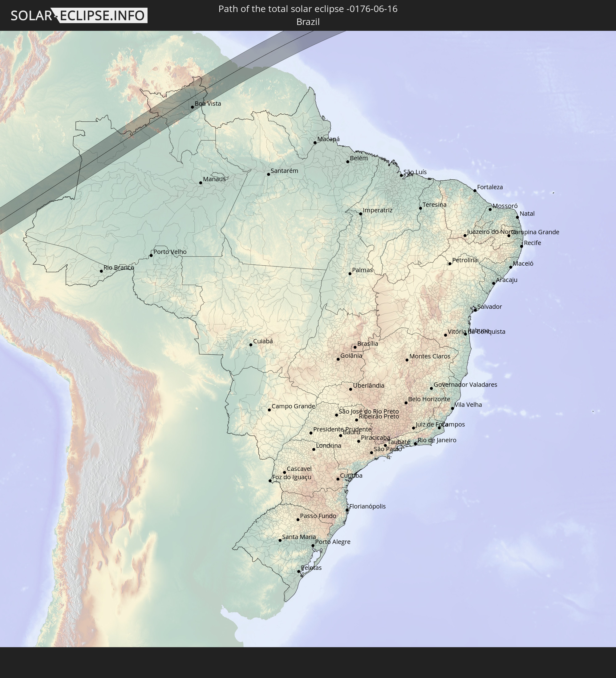 Brasilien
 Venezuela
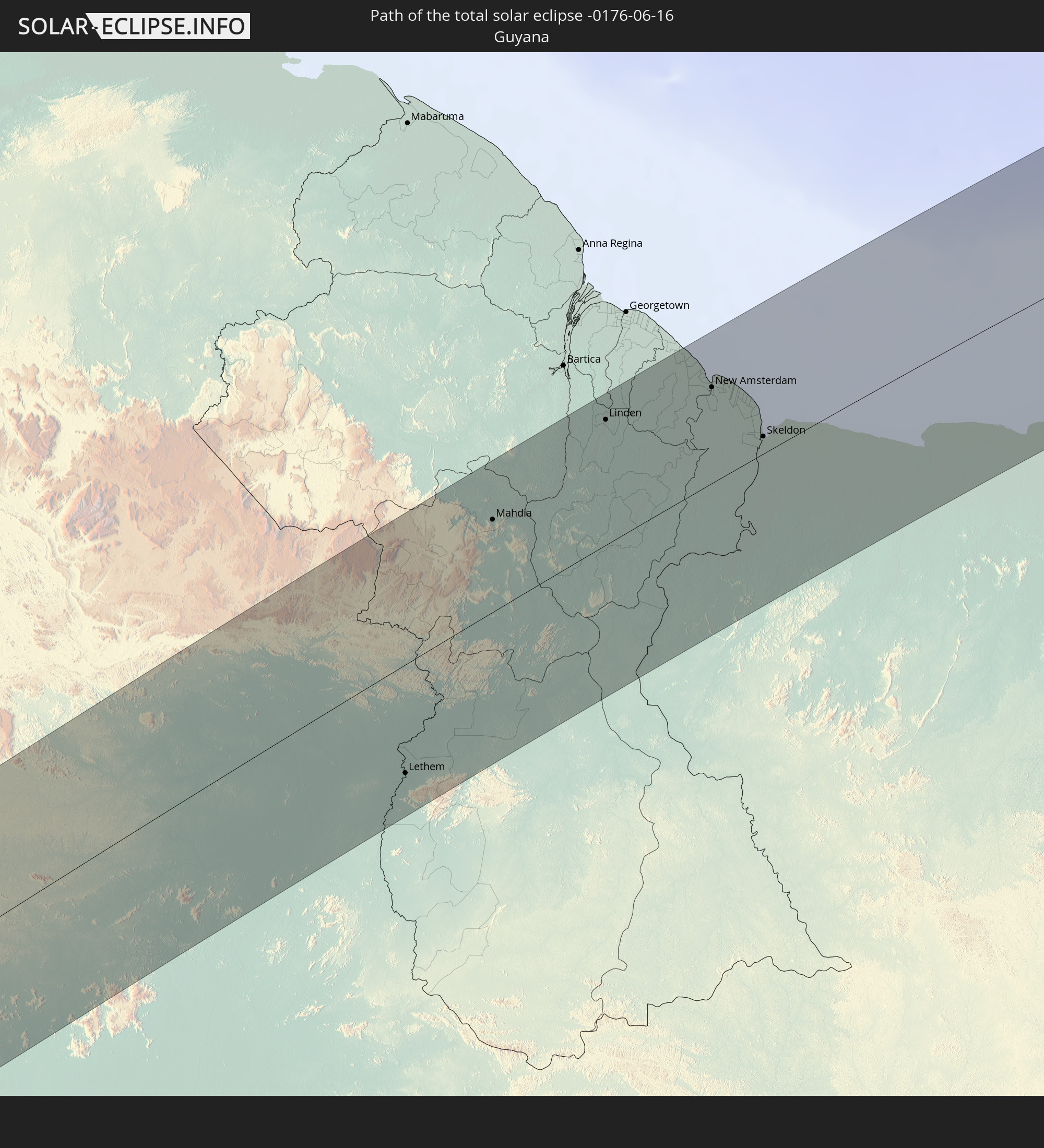 Guyana
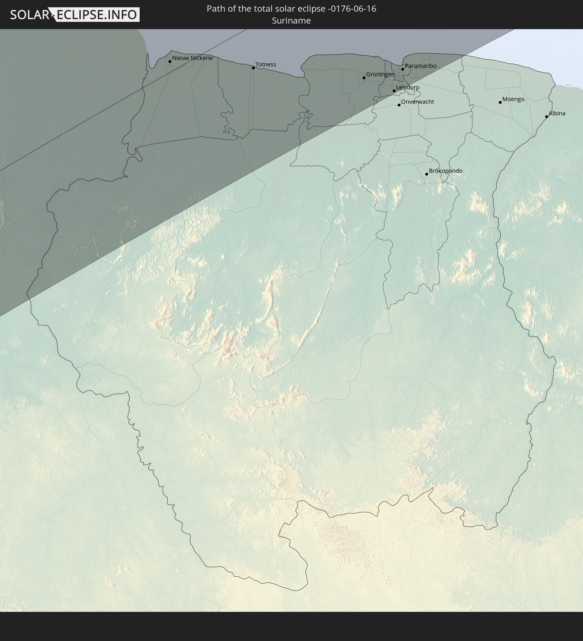 Suriname
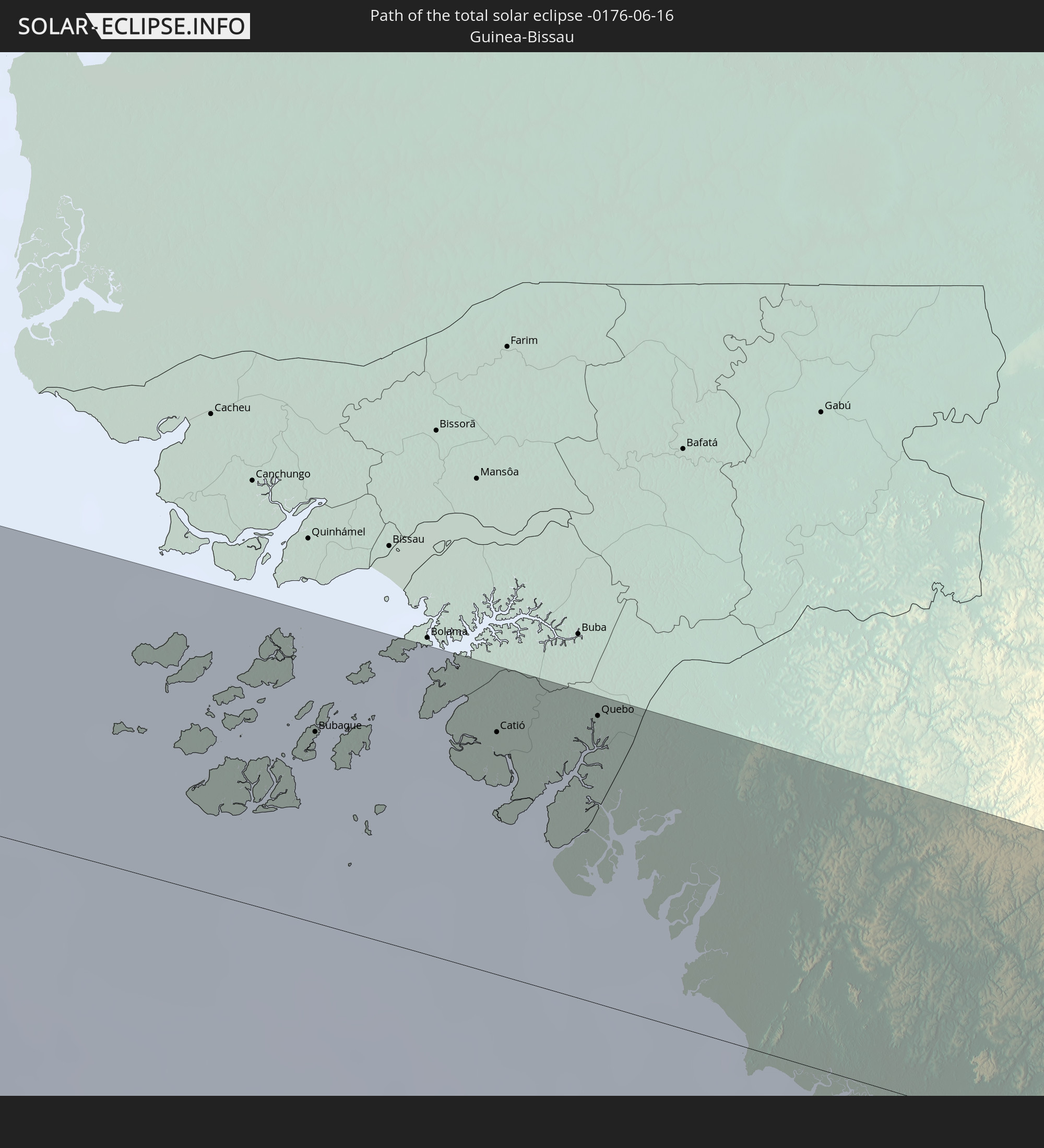 Guinea-Bissau
 Guinea
 Sierra Leone
 Liberia
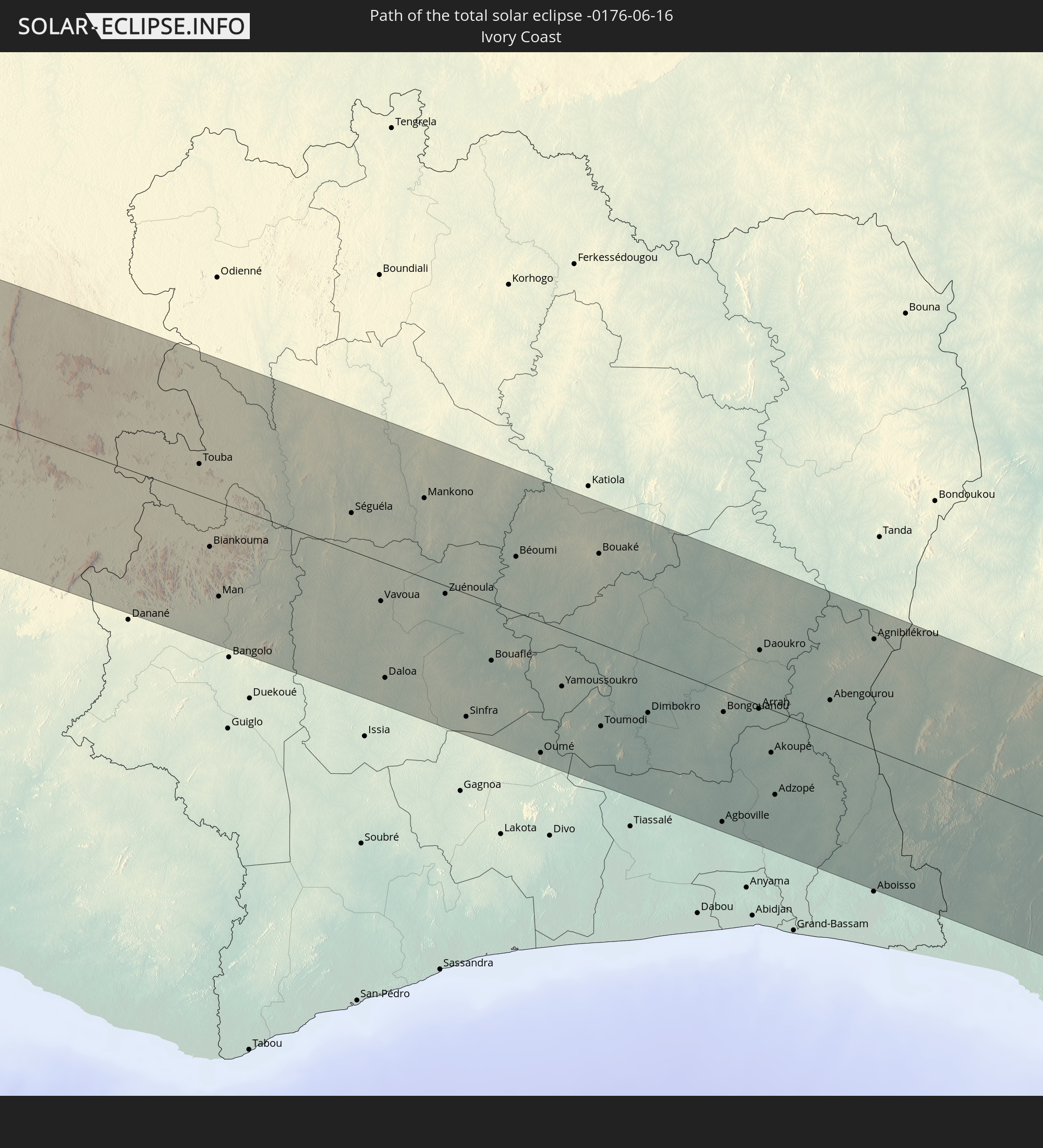 Elfenbeinküste
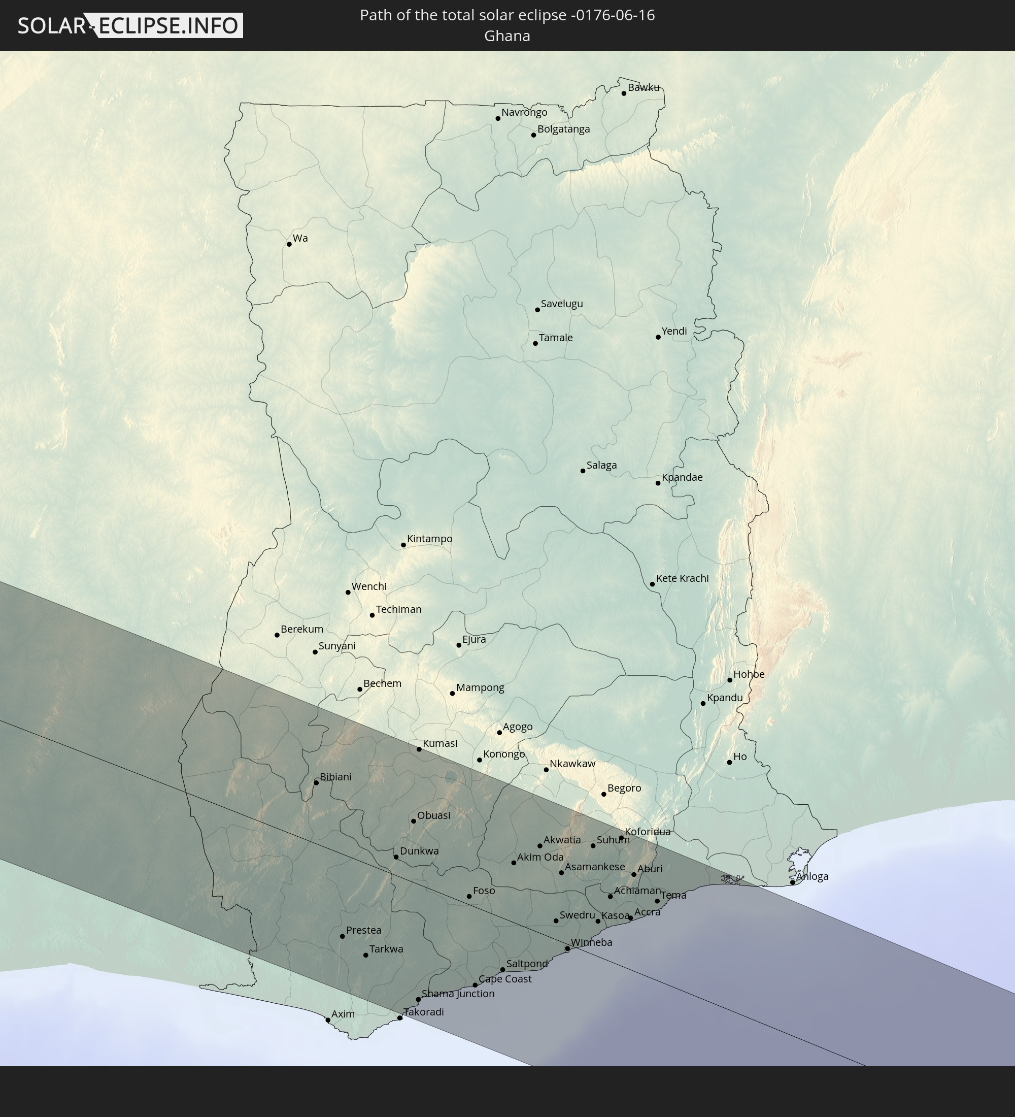 Ghana
Ghana
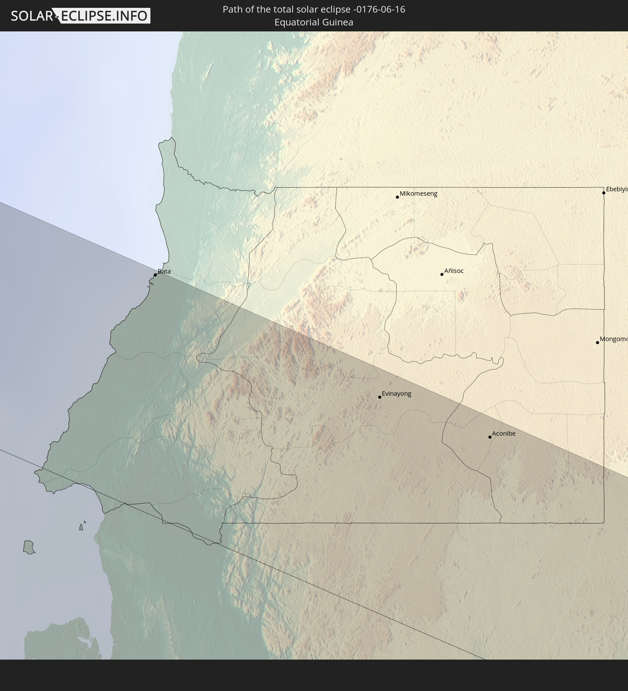 Äquatorialguinea
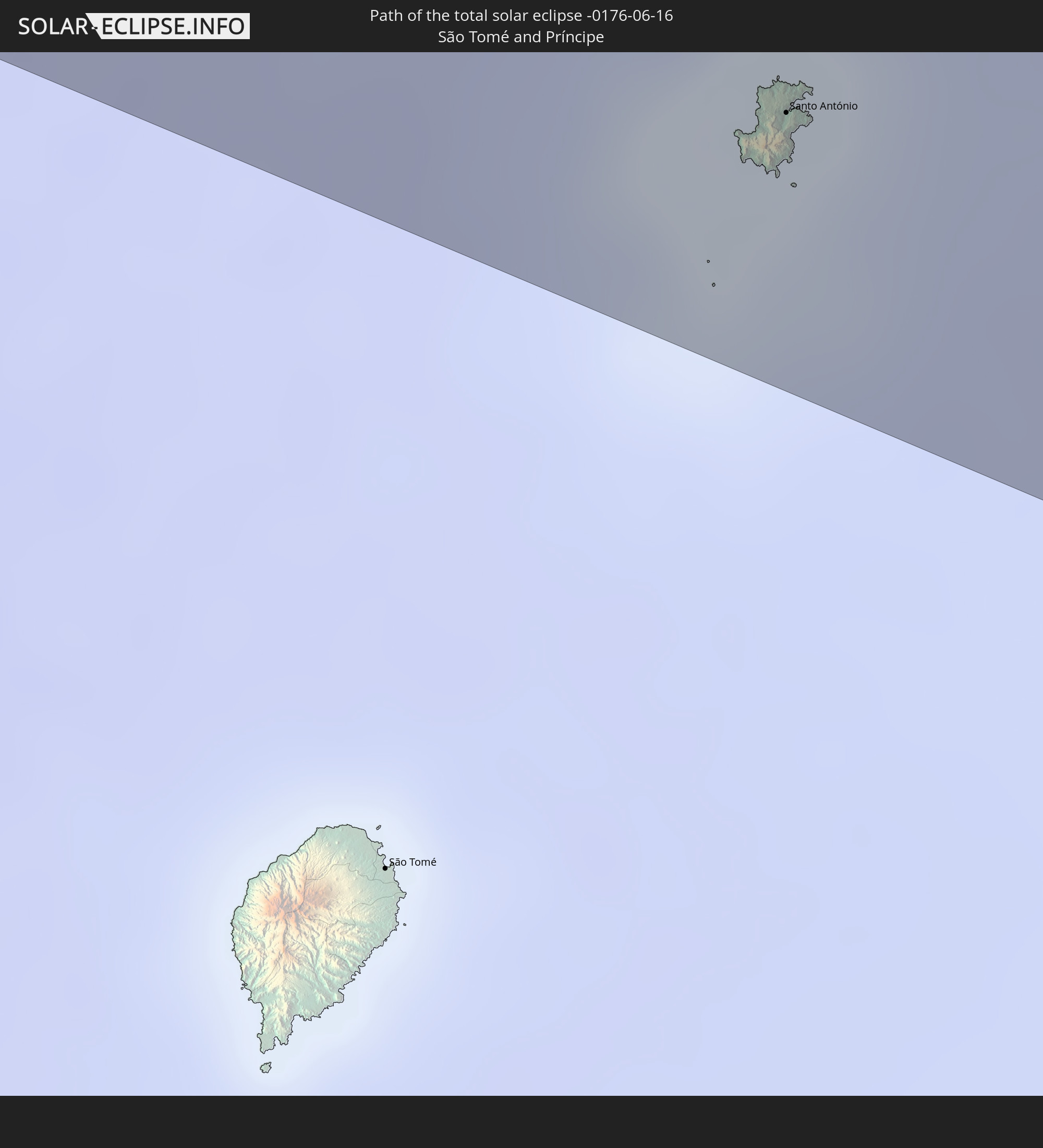 São Tomé und Príncipe
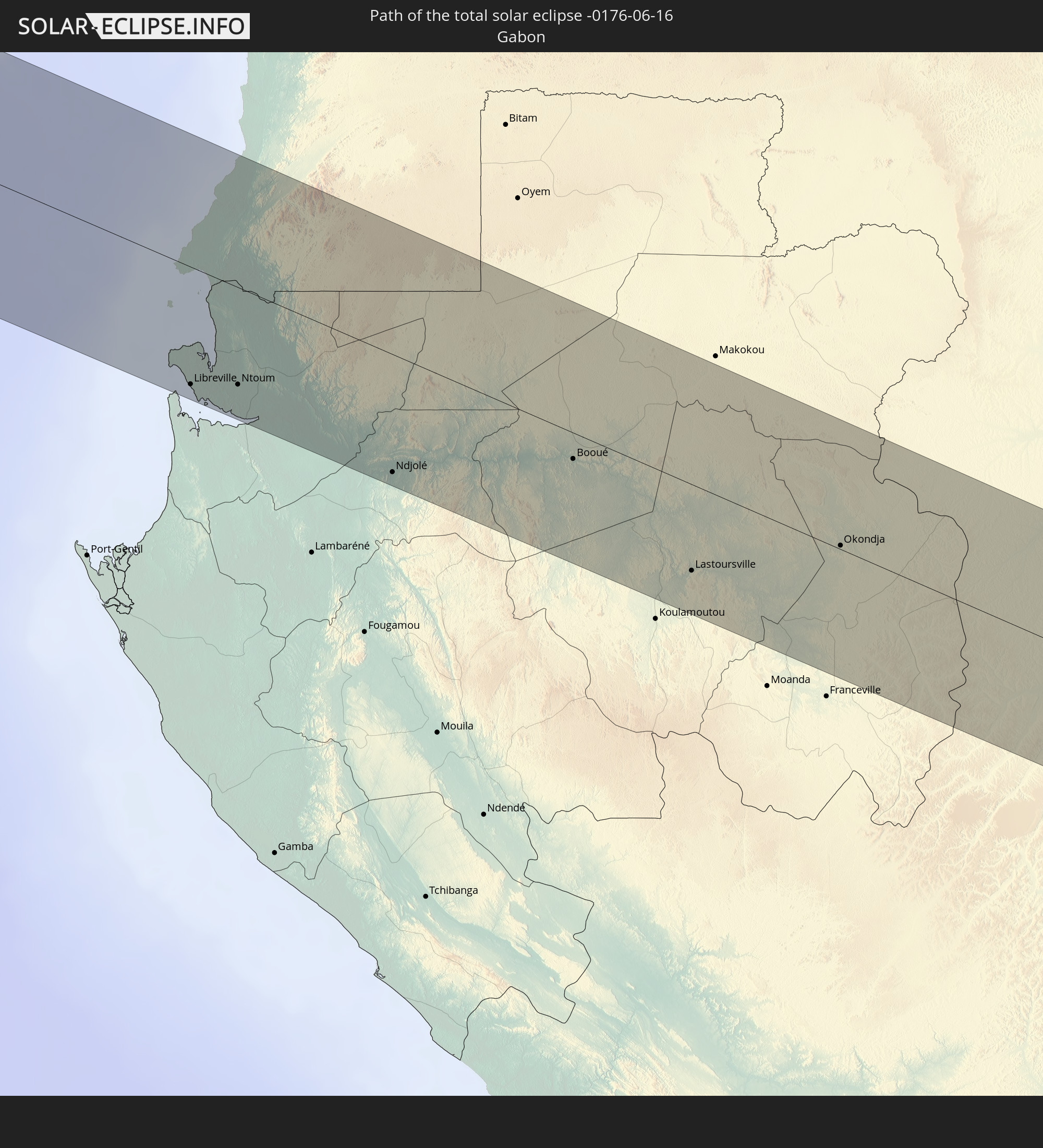 Gabun
Gabun
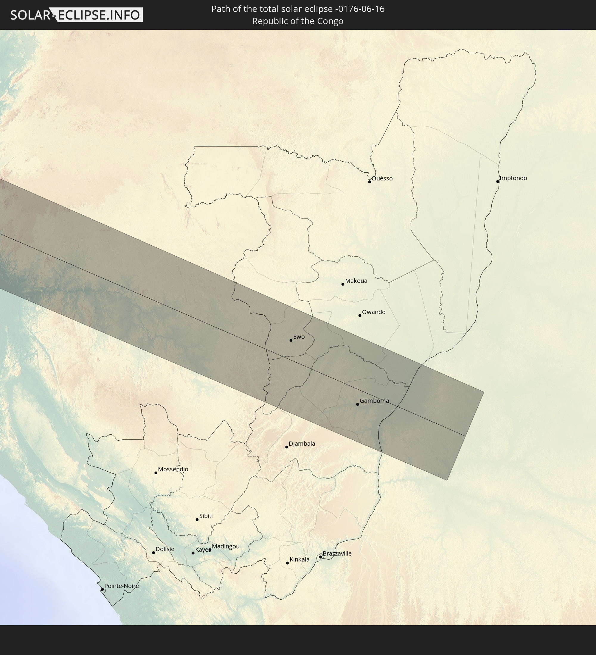 Republik Kongo
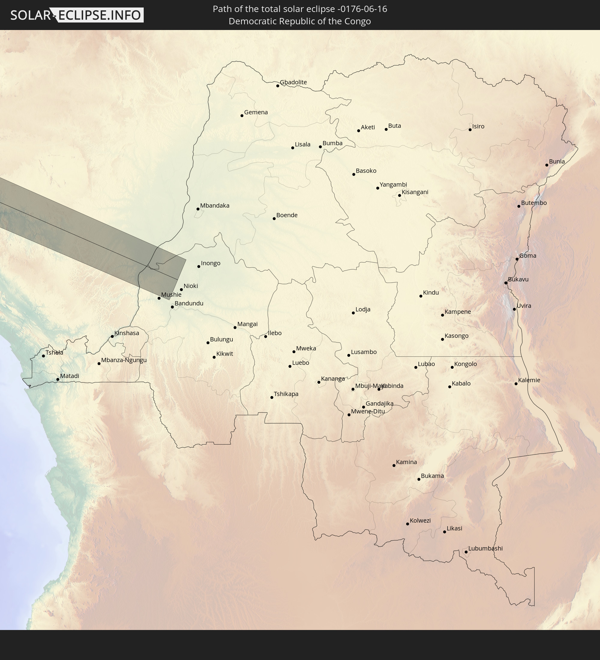 Demokratische Republik Kongo
In den folgenden Ländern ist die Sonnenfinsternis partiell zu sehen
 Vereinigte Staaten
 United States Minor Outlying Islands
 Mexiko
 Chile
Chile
 Guatemala
 Ecuador
 El Salvador
 Honduras
 Belize
 Nicaragua
 Costa Rica
 Kuba
Kuba
 Panama
 Kolumbien
 Kaimaninseln
 Peru
Peru
 Bahamas
 Jamaika
 Haiti
Haiti
 Brasilien
 Argentinien
 Venezuela
 Turks- und Caicosinseln
 Dominikanische Republik
 Aruba
Aruba
 Bolivien
 Puerto Rico
 Amerikanische Jungferninseln
 Bermuda
 Britische Jungferninseln
 Anguilla
 Saint-Martin
 Saint-Barthélemy
 St. Kitts und Nevis
 Paraguay
 Antigua und Barbuda
 Montserrat
 Trinidad und Tobago
 Guadeloupe
 Grenada
 Dominica
 St. Vincent und die Grenadinen
 Guyana
 Martinique
 St. Lucia
 Barbados
 Uruguay
 Suriname
 Französisch-Guayana
 Portugal
 Kap Verde
 Spanien
 Senegal
 Mauretanien
 Gambia
 Guinea-Bissau
 Guinea
 St. Helena
 Sierra Leone
 Marokko
 Mali
Mali
 Liberia
 Algerien
 Elfenbeinküste
 Burkina Faso
 Gibraltar
 Ghana
Ghana
 Togo
Togo
 Niger
Niger
 Benin
Benin
 Nigeria
 Äquatorialguinea
 São Tomé und Príncipe
 Tunesien
 Kamerun
 Gabun
Gabun
 Libyen
 Republik Kongo
 Angola
 Namibia
 Demokratische Republik Kongo
 Tschad
 Zentralafrikanische Republik
 Sudan
Sudan
 Ägypten
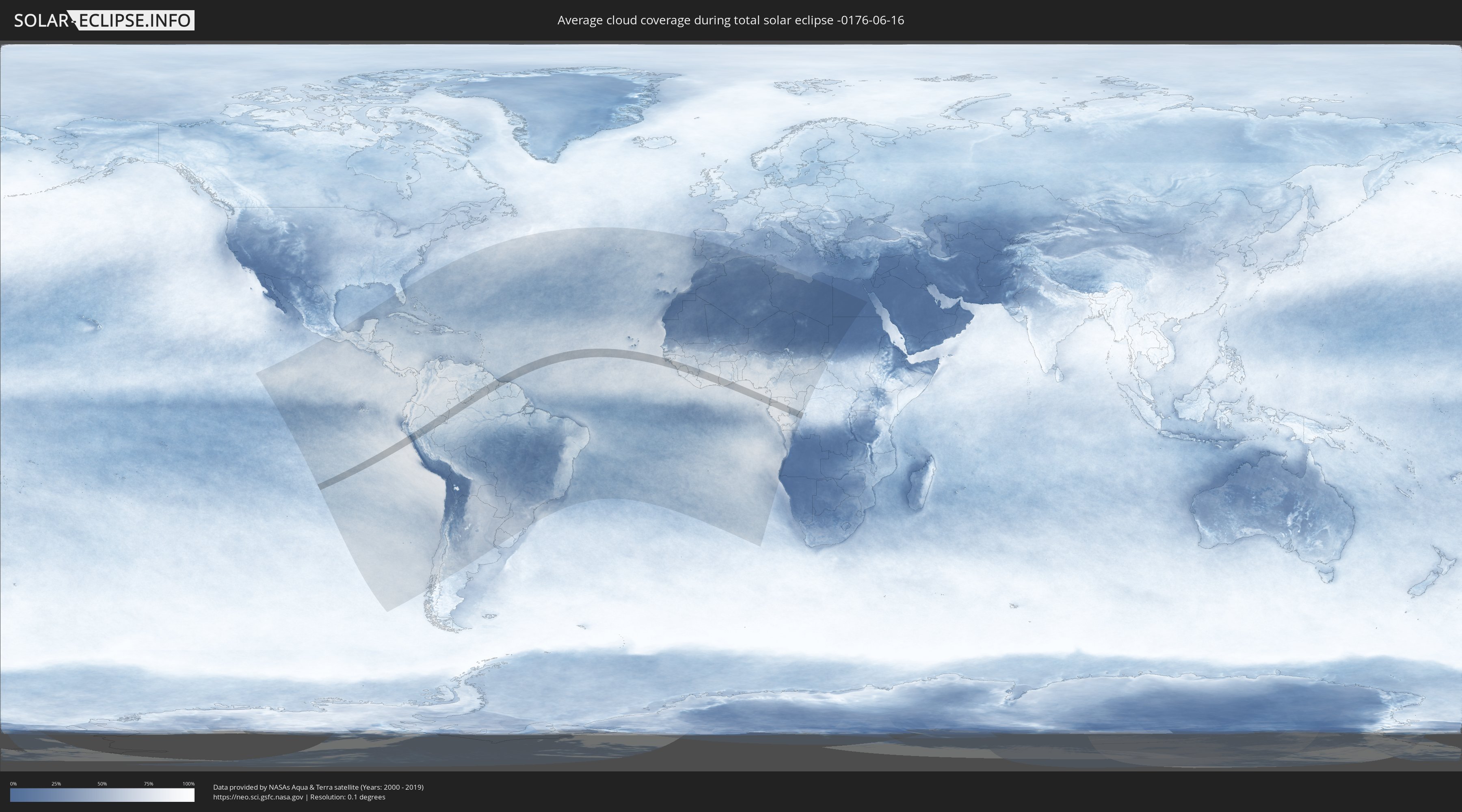
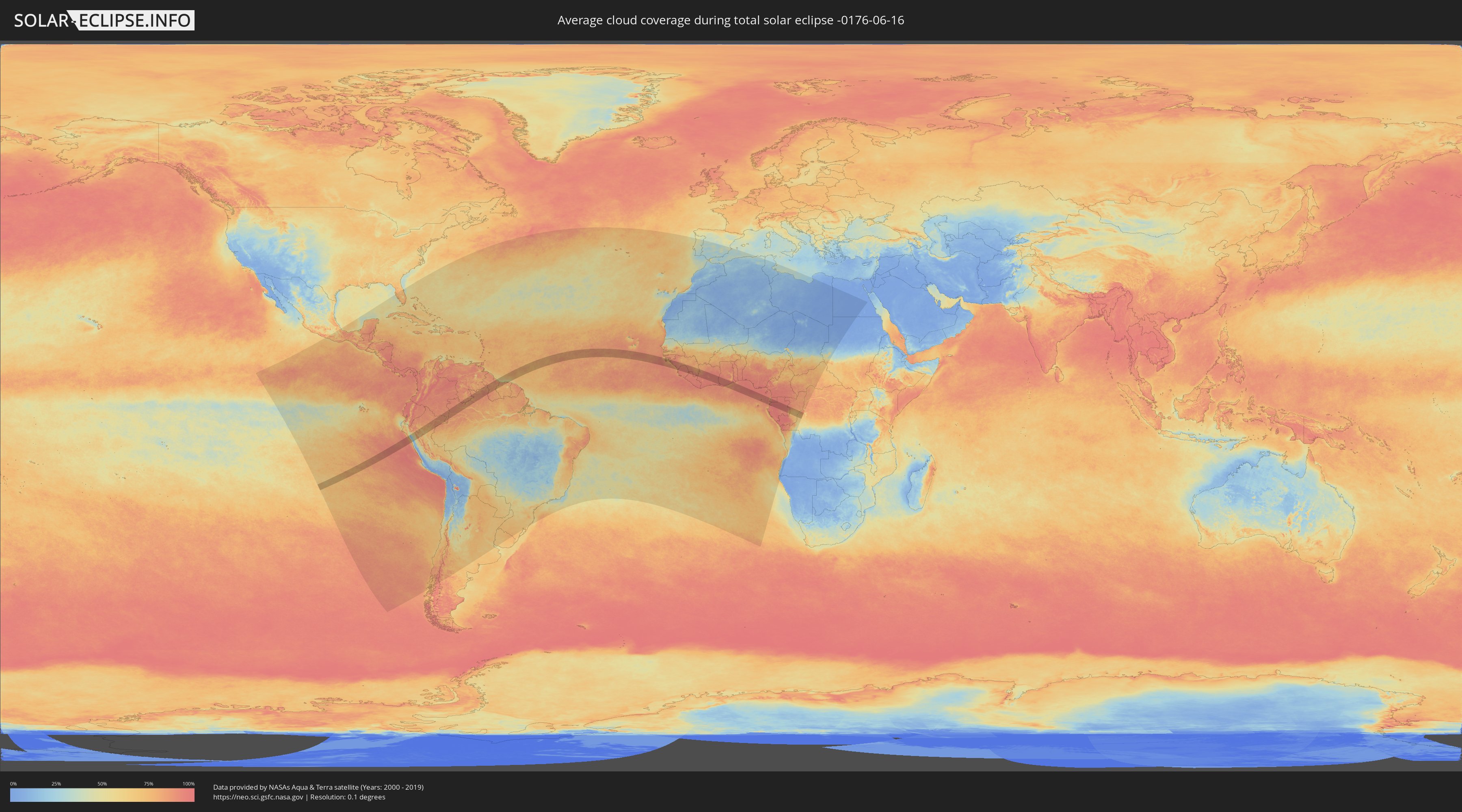
Wie wird das Wetter während der totalen Sonnenfinsternis am 16.06.-0176?
Wo ist der beste Ort, um die totale Sonnenfinsternis vom 16.06.-0176 zu beobachten?
Die folgenden Karten zeigen die durchschnittliche Bewölkung für den Tag, an dem die totale Sonnenfinsternis
stattfindet. Mit Hilfe der Karten lässt sich der Ort entlang des Finsternispfades eingrenzen,
der die besten Aussichen auf einen klaren wolkenfreien Himmel bietet.
Trotzdem muss man immer lokale Gegenenheiten beachten und sollte sich genau über das Wetter an seinem
gewählten Beobachtungsort informieren.
Die Daten stammen von den beiden NASA-Satelliten
AQUA und TERRA
und wurden über einen Zeitraum von 19 Jahren (2000 - 2019) gemittelt.
Detaillierte Länderkarten
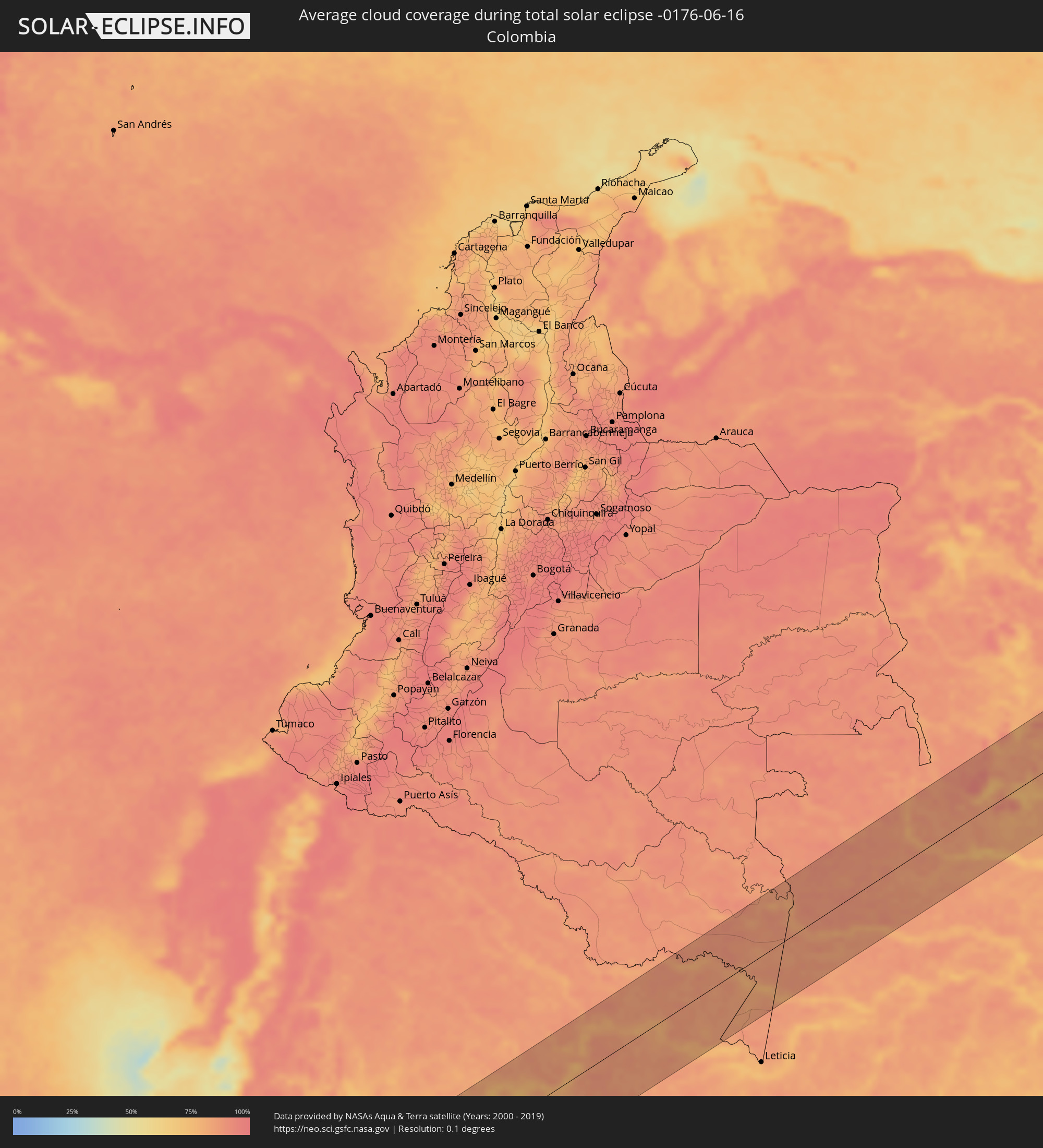 Kolumbien
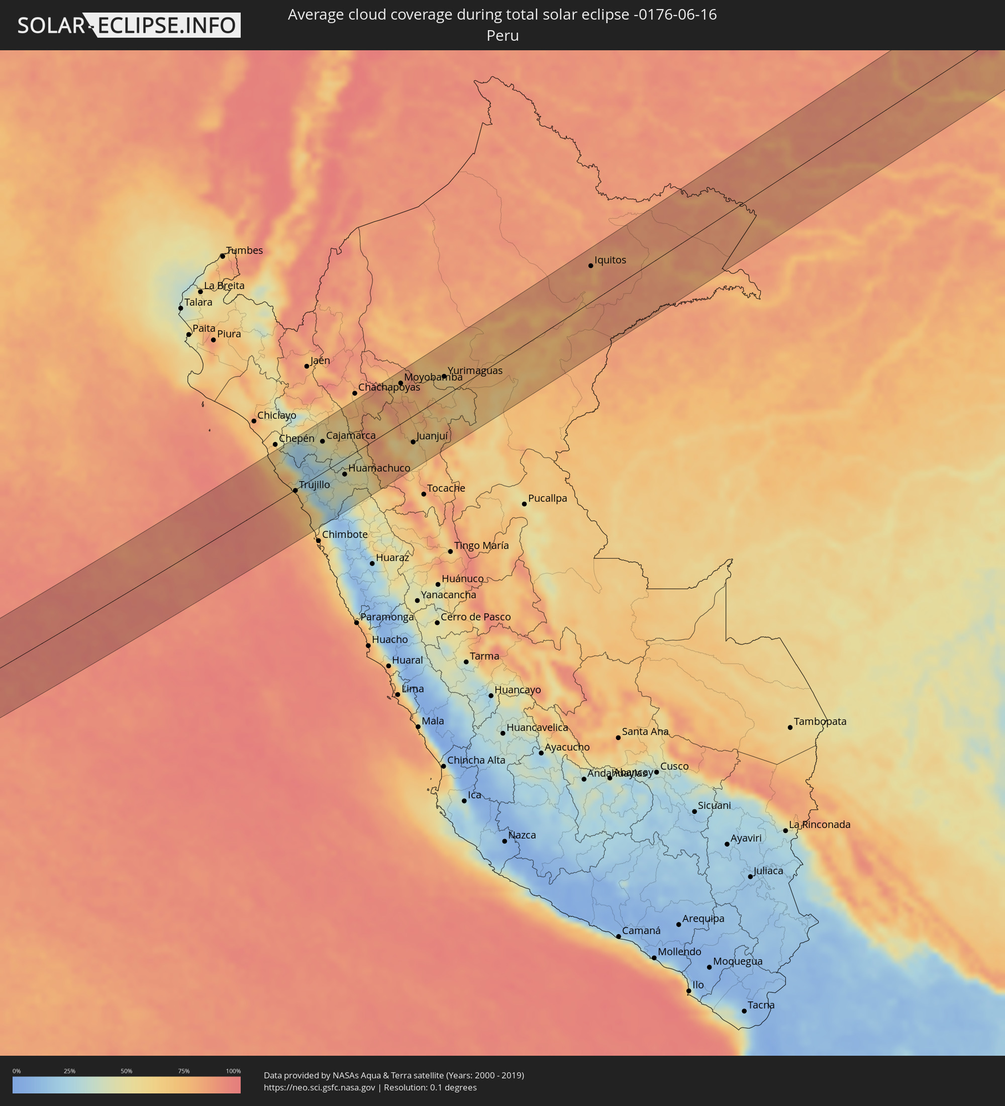 Peru
Peru
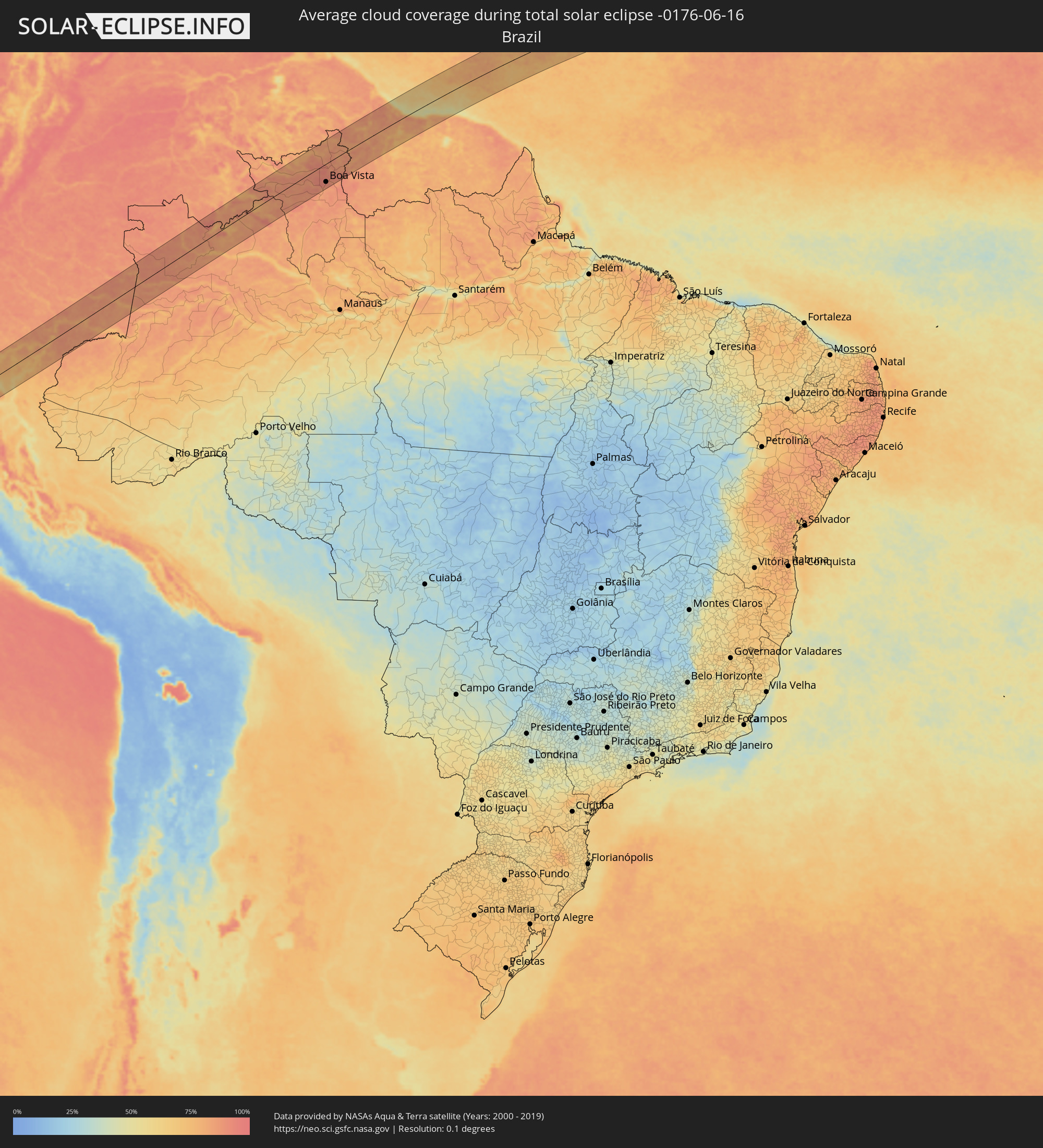 Brasilien
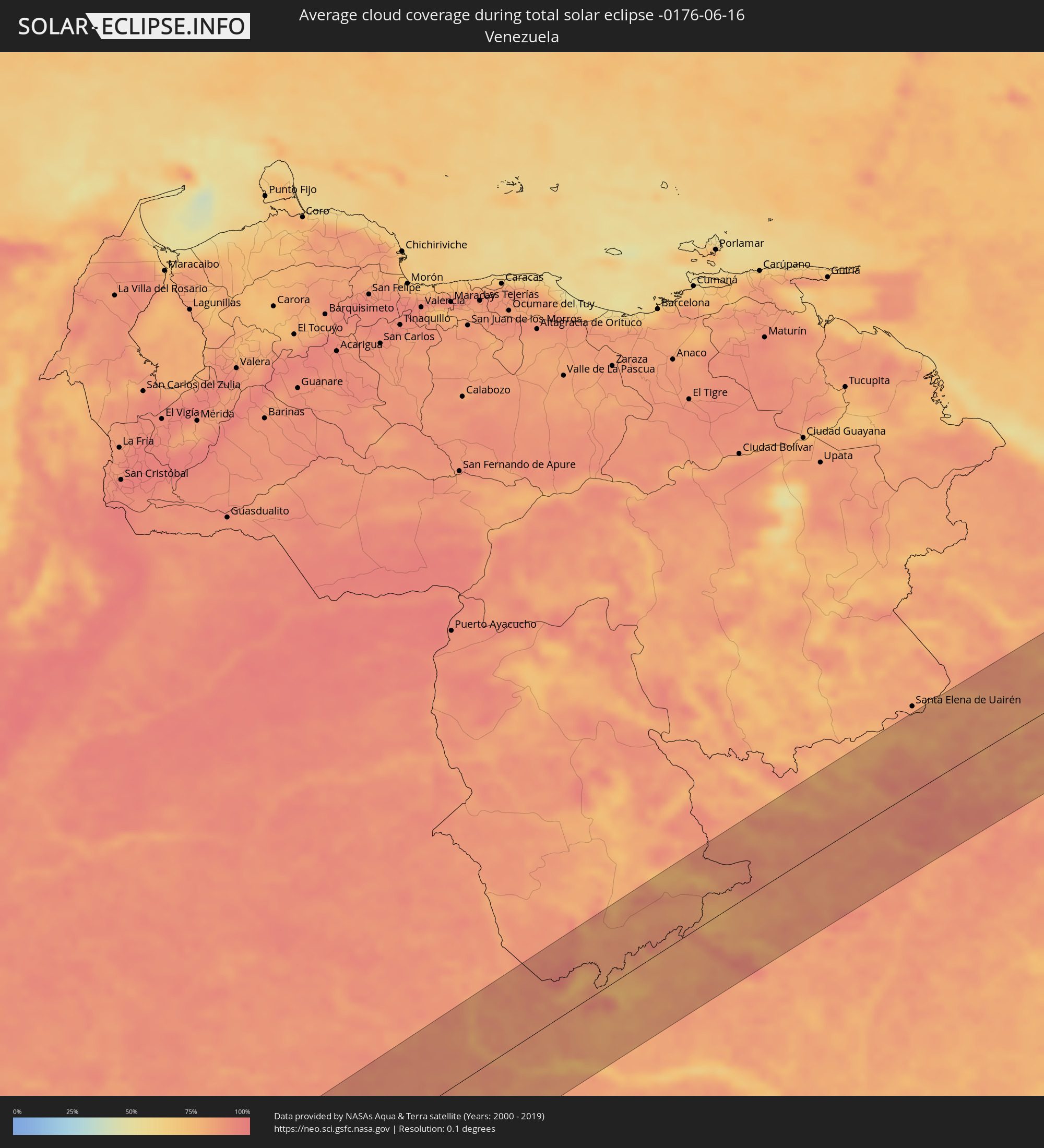 Venezuela
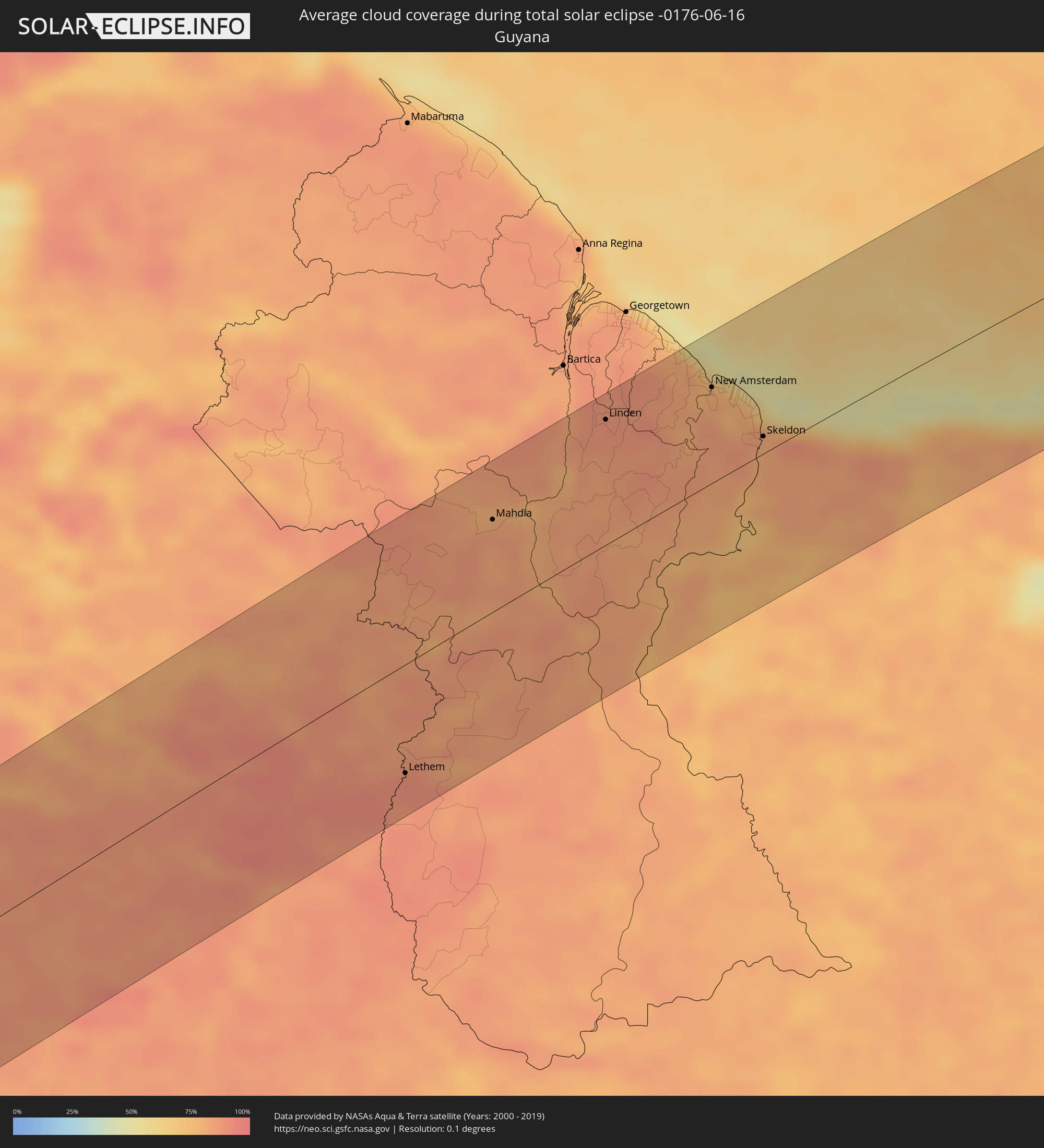 Guyana
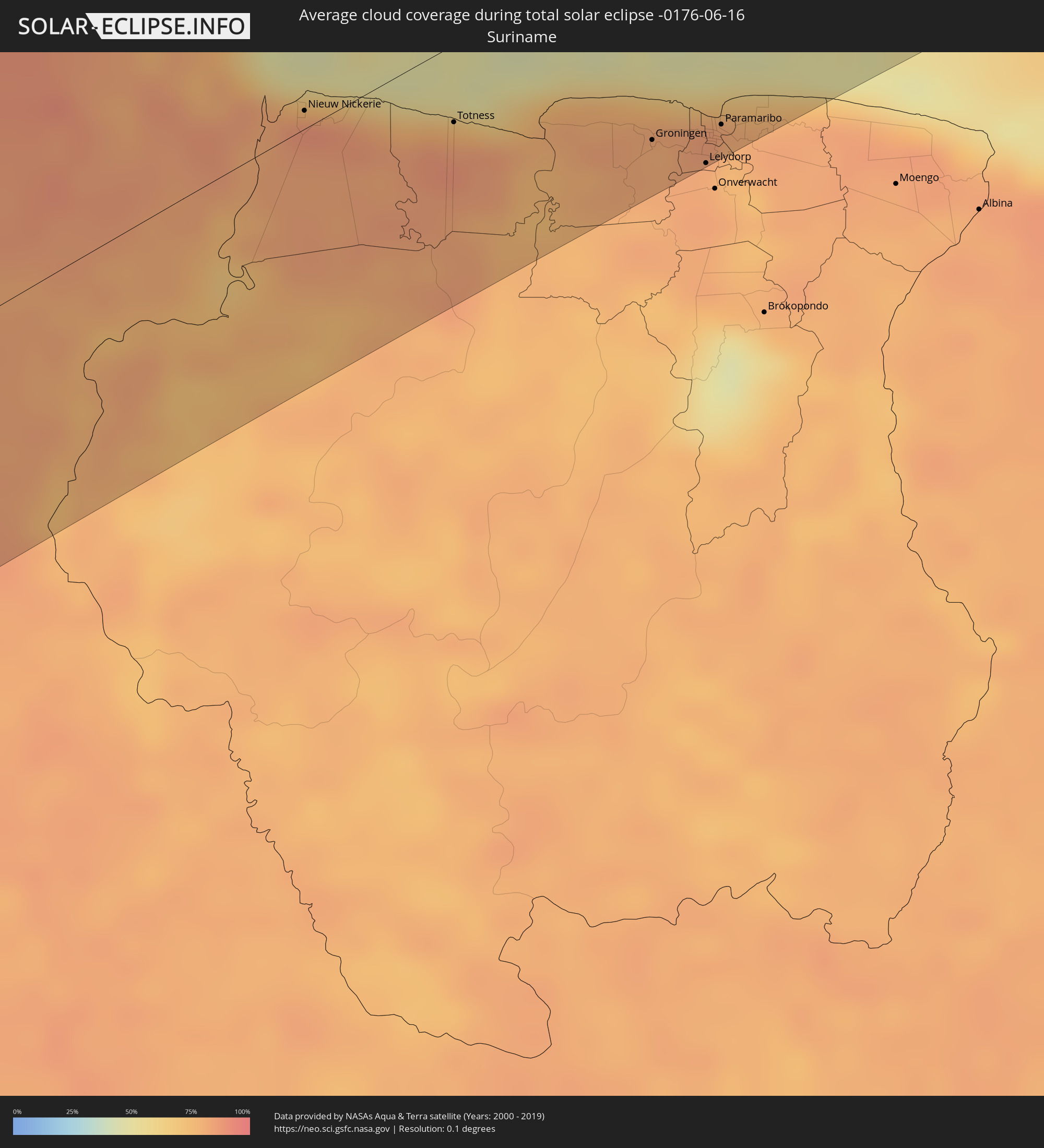 Suriname
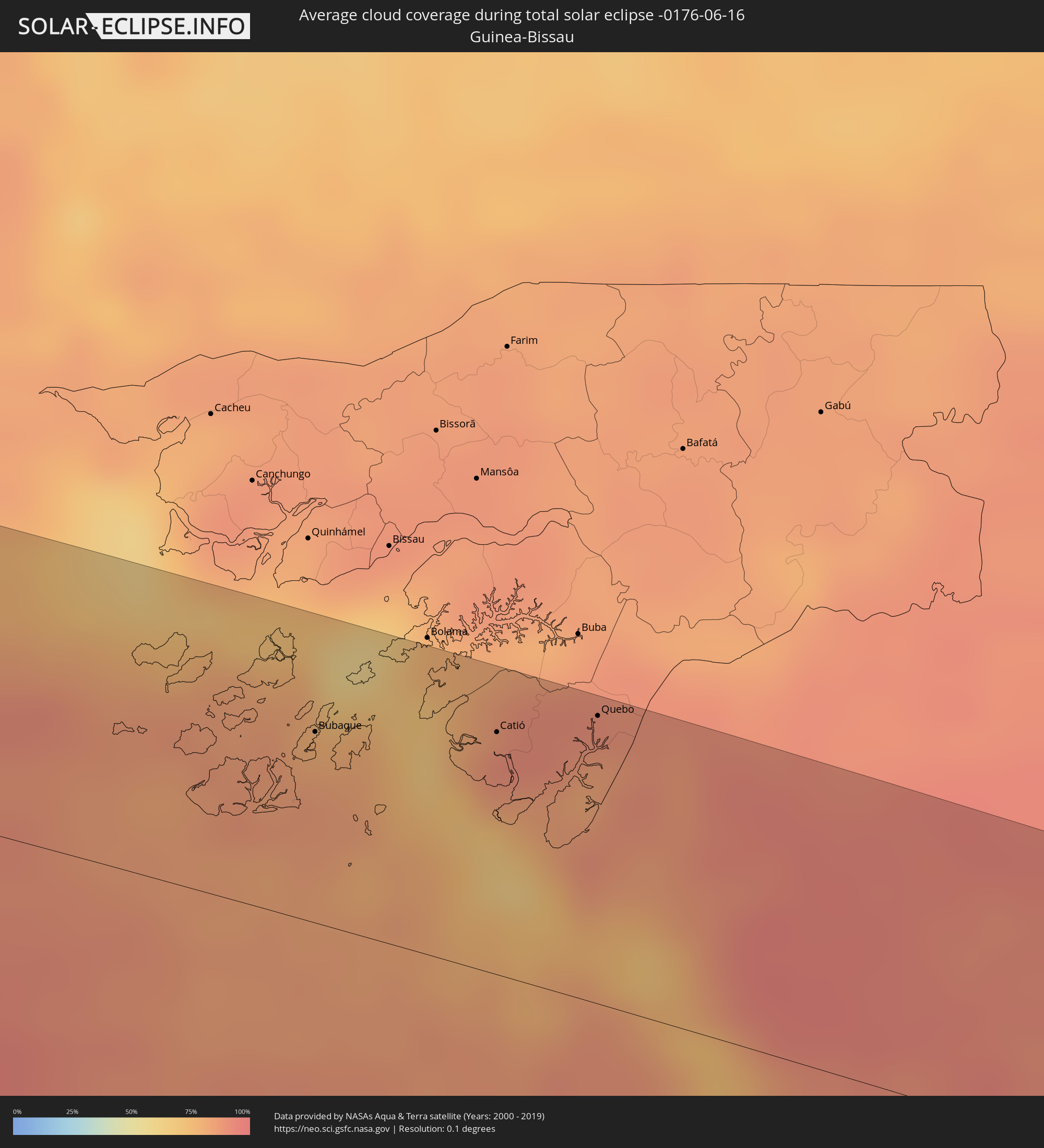 Guinea-Bissau
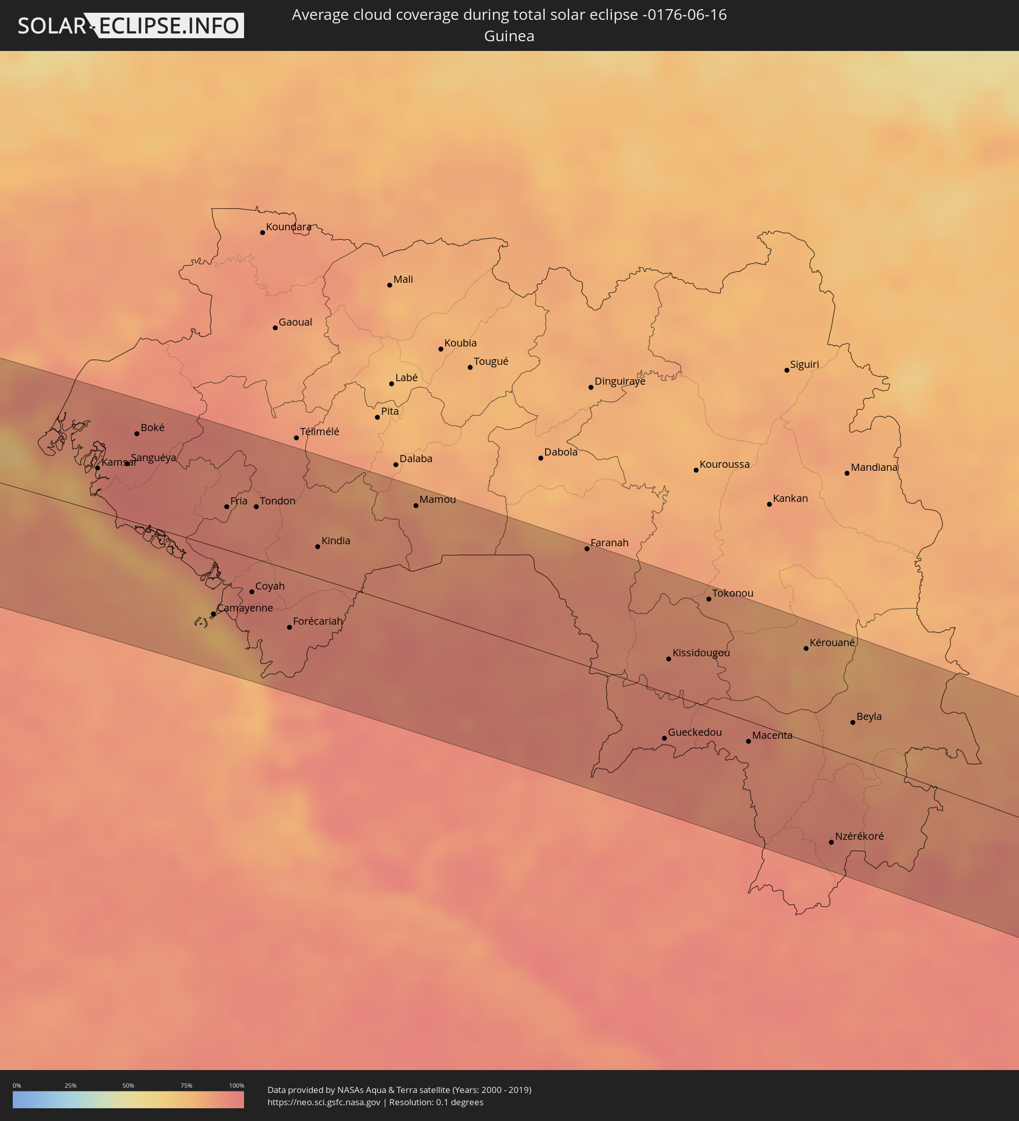 Guinea
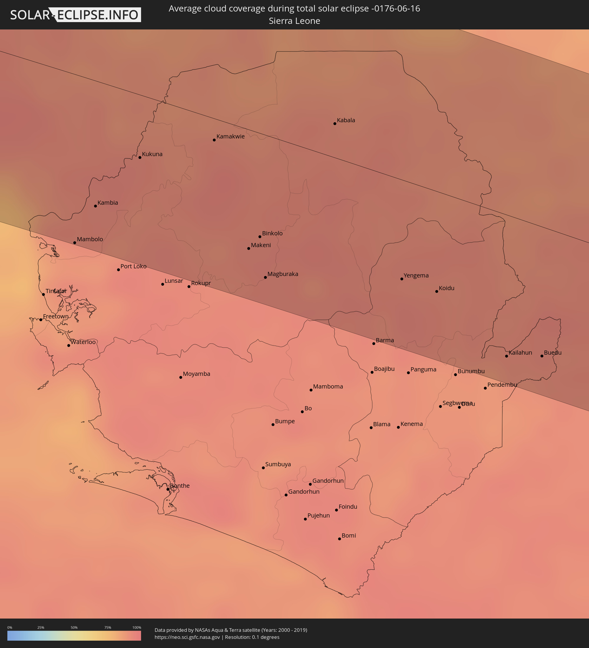 Sierra Leone
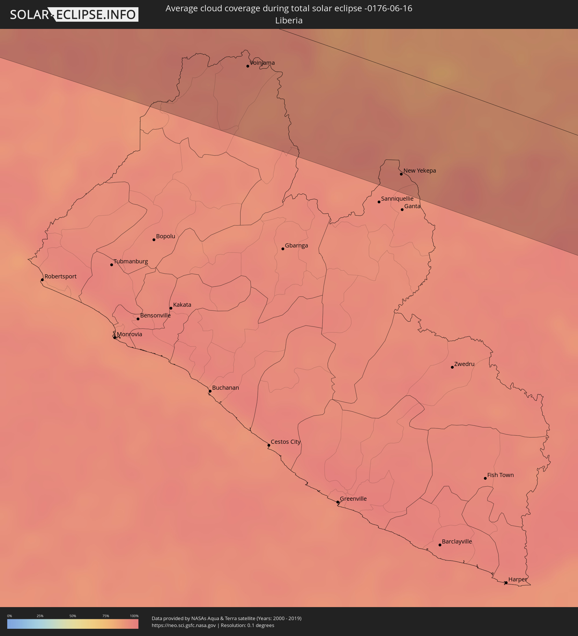 Liberia
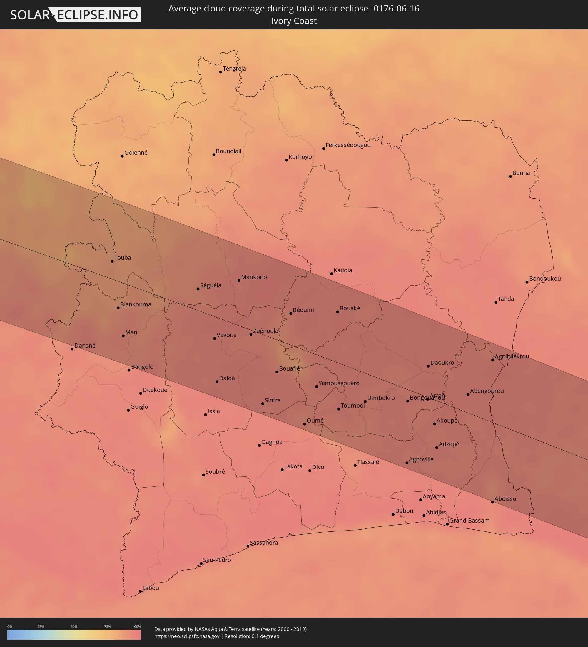 Elfenbeinküste
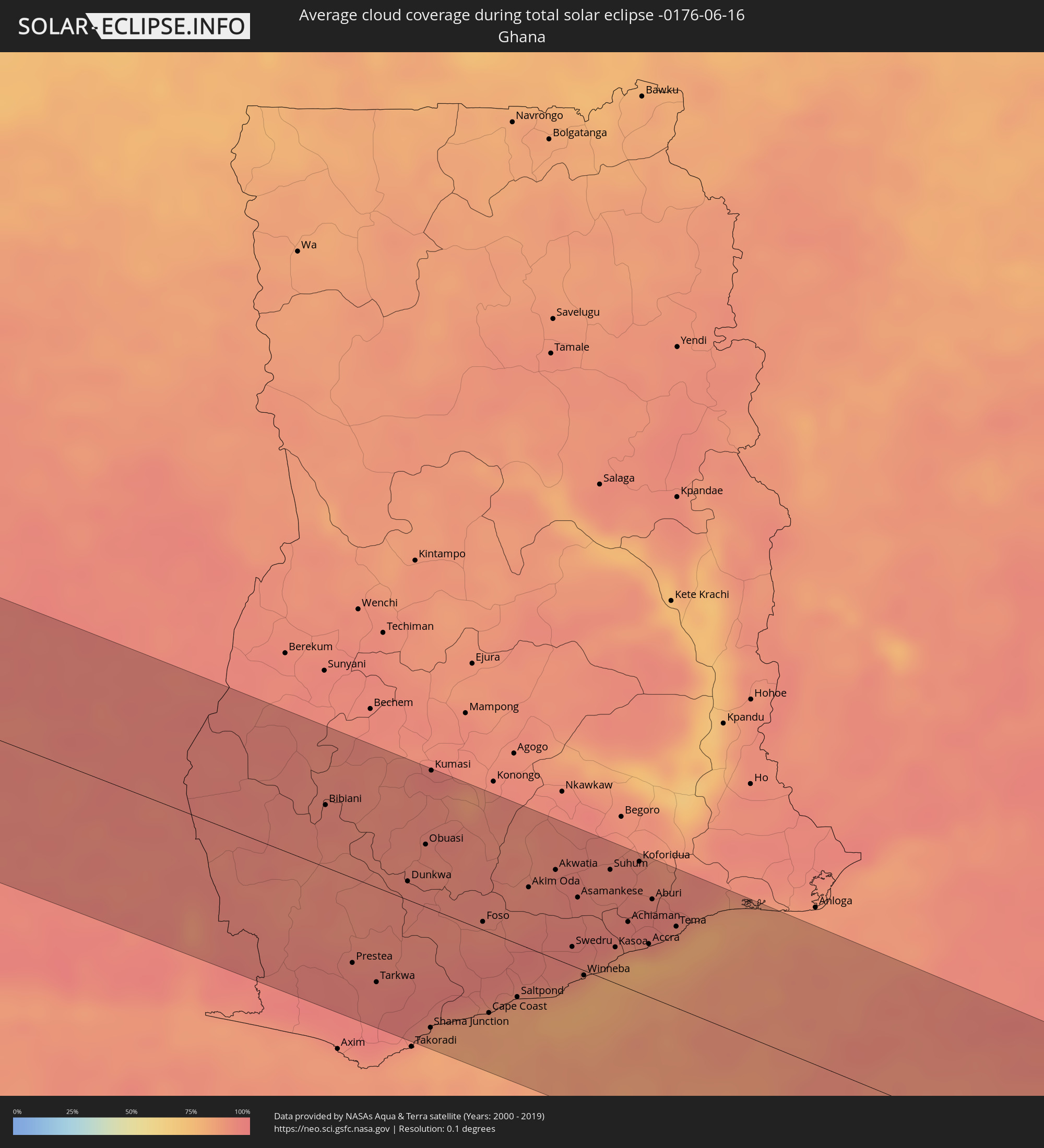 Ghana
Ghana
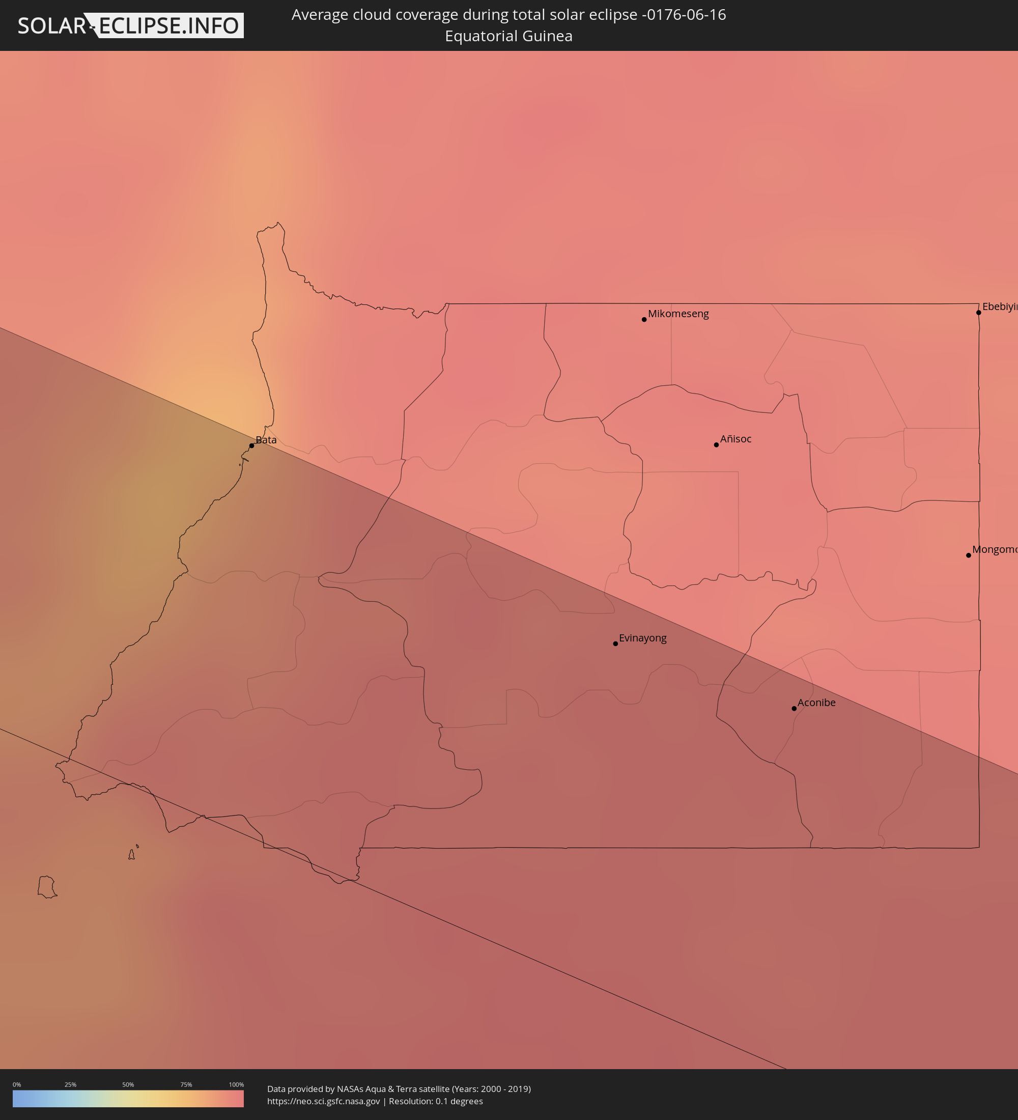 Äquatorialguinea
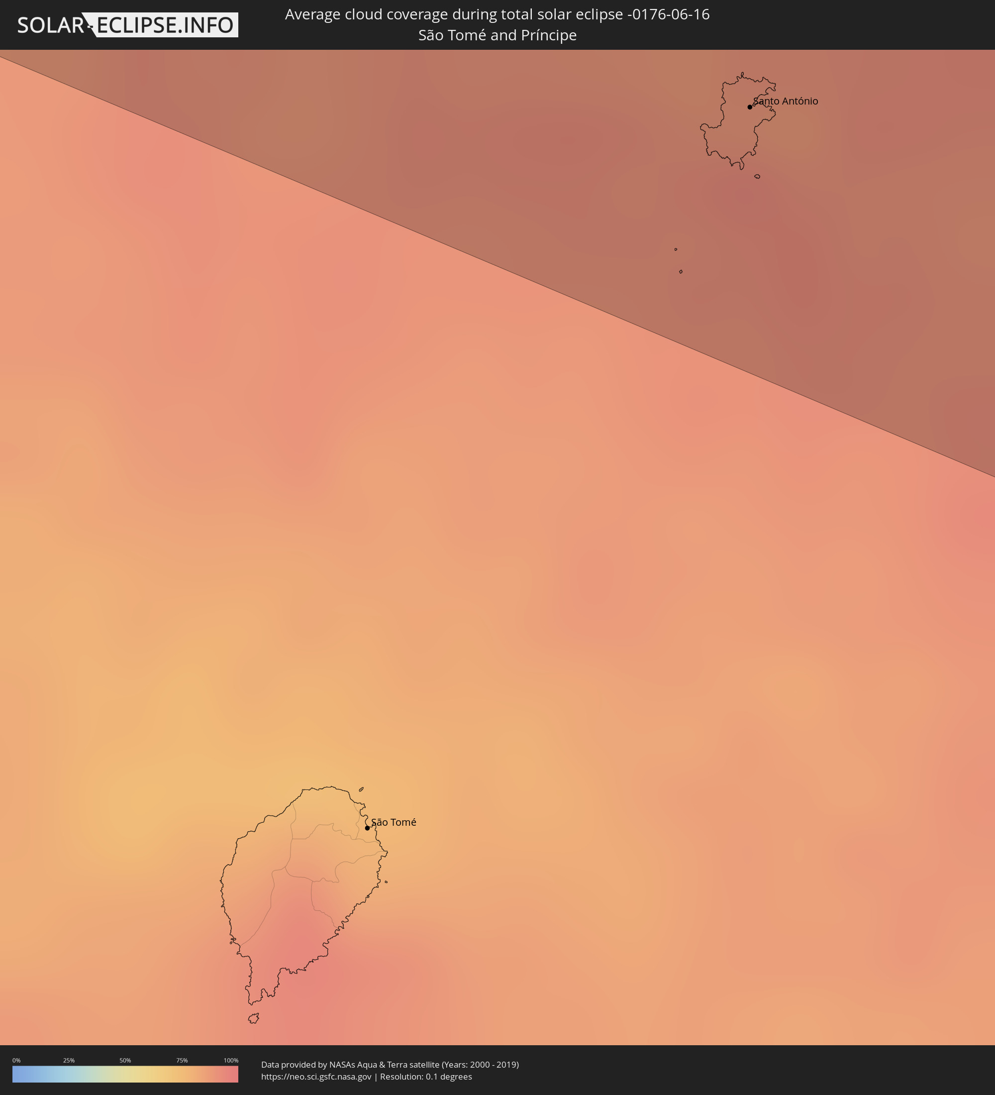 São Tomé und Príncipe
 Gabun
Gabun
 Republik Kongo
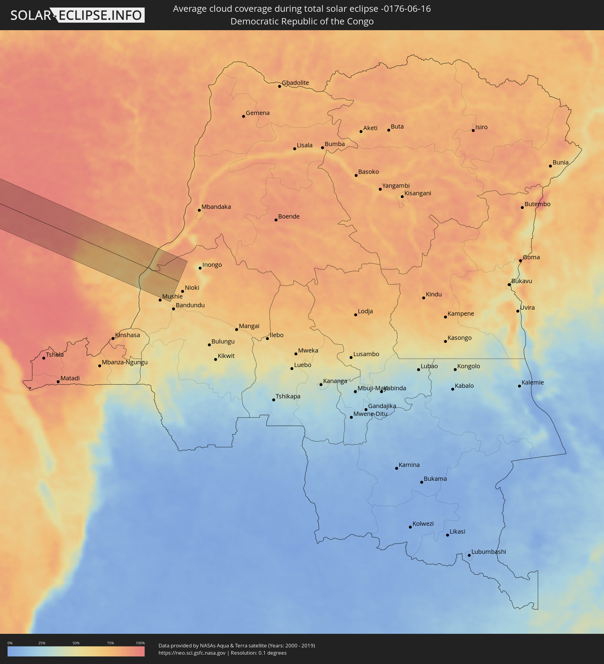 Demokratische Republik Kongo
Orte im Finsternispfad
Die nachfolgene Tabelle zeigt Städte und Orte mit mehr als 5.000 Einwohnern, die sich im Finsternispfad befinden. Städte mit mehr als 100.000 Einwohnern sind dick gekennzeichnet. Mit einem Klick auf den Ort öffnet sich eine Detailkarte die die Lage des jeweiligen Ortes zusammen mit dem Verlauf der zentralen Finsternis präsentiert.
| Ort | Typ | Dauer der Verfinsterung | Ortszeit bei maximaler Verfinsterung | Entfernung zur Zentrallinie | Ø Bewölkung |
|
San Pedro de Lloc, La Libertad
|
total | - | 08:20:35 UTC-05:08 | 90 km | 70% |
|
Santiago de Cao, La Libertad
|
total | - | 08:20:32 UTC-05:08 | 24 km | 76% |
|
Chocope, La Libertad
|
total | - | 08:20:38 UTC-05:08 | 39 km | 75% |
|
Trujillo, La Libertad
|
total | - | 08:20:37 UTC-05:08 | 3 km | 74% |
|
Virú, La Libertad
|
total | - | 08:20:43 UTC-05:08 | 47 km | 75% |
|
Cajamarca, Cajamarca
|
total | - | 08:21:38 UTC-05:08 | 56 km | 40% |
|
Huamachuco, La Libertad
|
total | - | 08:21:40 UTC-05:08 | 29 km | 44% |
|
Rioja, San Martín
|
total | - | 08:23:36 UTC-05:08 | 82 km | 73% |
|
Moyobamba, San Martín
|
total | - | 08:23:48 UTC-05:08 | 73 km | 68% |
|
Saposoa, San Martín
|
total | - | 08:23:26 UTC-05:08 | 24 km | 65% |
|
Juanjuí, San Martín
|
total | - | 08:23:20 UTC-05:08 | 49 km | 58% |
|
Bellavista, San Martín
|
total | - | 08:23:33 UTC-05:08 | 46 km | 67% |
|
Yurimaguas, Loreto
|
total | - | 08:24:46 UTC-05:08 | 35 km | 63% |
|
Iquitos, Loreto
|
total | - | 08:29:33 UTC-05:08 | 65 km | 83% |
|
São Gabriel da Cachoeira, Amazonas
|
total | - | 09:47:25 UTC-04:02 | 29 km | 81% |
|
Boa Vista, Roraima
|
total | - | 10:02:24 UTC-04:02 | 80 km | 91% |
|
Lethem, Upper Takutu-Upper Essequibo
|
total | - | 10:14:53 UTC-03:52 | 77 km | 90% |
|
Mahdia, Potaro-Siparuni
|
total | - | 10:18:28 UTC-03:52 | 66 km | 80% |
|
Linden, Upper Demerara-Berbice
|
total | - | 10:21:14 UTC-03:52 | 89 km | 89% |
|
Fort Wellington, Mahaica-Berbice
|
total | - | 10:23:18 UTC-03:52 | 87 km | 75% |
|
Rosignol, Mahaica-Berbice
|
total | - | 10:23:19 UTC-03:52 | 72 km | 77% |
|
New Amsterdam, East Berbice-Corentyne
|
total | - | 10:23:20 UTC-03:52 | 69 km | 81% |
|
Skeldon, East Berbice-Corentyne
|
total | - | 10:23:48 UTC-03:52 | 12 km | 81% |
|
Nieuw Nickerie, Nickerie
|
total | - | 10:36:14 UTC-03:40 | 8 km | 86% |
|
Totness, Coronie
|
total | - | 10:37:44 UTC-03:40 | 32 km | 75% |
|
Groningen, Saramacca
|
total | - | 10:39:45 UTC-03:40 | 86 km | 81% |
|
Lelydorp, Wanica
|
total | - | 10:40:13 UTC-03:40 | 108 km | 80% |
|
Paramaribo, Paramaribo
|
total | - | 10:40:35 UTC-03:40 | 96 km | 83% |
|
Nieuw Amsterdam, Commewijne
|
total | - | 10:40:48 UTC-03:40 | 98 km | 80% |
|
Bubaque, Bolama and Bijagos
|
total | - | 15:10:46 UTC-01:02 | 64 km | 81% |
|
Catió, Tombali
|
total | - | 15:11:45 UTC-01:02 | 81 km | 90% |
|
Quebo, Tombali
|
total | - | 15:12:17 UTC-01:02 | 96 km | 86% |
|
Kamsar, Boke
|
total | - | 15:59:12 UTC-00:16 | 35 km | 88% |
|
Boké, Boke
|
total | - | 15:59:38 UTC-00:16 | 73 km | 94% |
|
Camayenne, Conakry
|
total | - | 16:00:58 UTC-00:16 | 57 km | 73% |
|
Fria, Boke
|
total | - | 16:00:55 UTC-00:16 | 35 km | 90% |
|
Coyah, Kindia
|
total | - | 16:01:24 UTC-00:16 | 29 km | 95% |
|
Tondon, Kindia
|
total | - | 16:01:17 UTC-00:16 | 43 km | 90% |
|
Forécariah, Kindia
|
total | - | 16:01:56 UTC-00:16 | 48 km | 93% |
|
Mambolo, Northern Province
|
total | - | 16:02:08 UTC-00:16 | 101 km | 88% |
|
Kambia, Northern Province
|
total | - | 16:02:16 UTC-00:16 | 75 km | 93% |
|
Kindia, Kindia
|
total | - | 16:02:07 UTC-00:16 | 26 km | 90% |
|
Kukuna, Northern Province
|
total | - | 16:02:36 UTC-00:16 | 38 km | 94% |
|
Kamakwie, Northern Province
|
total | - | 16:03:12 UTC-00:16 | 13 km | 93% |
|
Mamou, Mamou
|
total | - | 16:03:11 UTC-00:16 | 85 km | 88% |
|
Makeni, Northern Province
|
total | - | 16:03:39 UTC-00:16 | 71 km | 94% |
|
Binkolo, Northern Province
|
total | - | 16:03:44 UTC-00:16 | 62 km | 93% |
|
Masingbi, Northern Province
|
total | - | 16:03:49 UTC-00:16 | 79 km | 93% |
|
Magburaka, Northern Province
|
total | - | 16:03:50 UTC-00:16 | 85 km | 93% |
|
Kabala, Northern Province
|
total | - | 16:04:11 UTC-00:16 | 20 km | 91% |
|
Yengema, Eastern Province
|
total | - | 16:04:58 UTC-00:16 | 59 km | 94% |
|
Motema, Eastern Province
|
total | - | 16:05:13 UTC-00:16 | 64 km | 93% |
|
Koidu, Eastern Province
|
total | - | 16:05:16 UTC-00:16 | 60 km | 93% |
|
Kailahun, Eastern Province
|
total | - | 16:05:54 UTC-00:16 | 84 km | 91% |
|
Buedu, Eastern Province
|
total | - | 16:06:11 UTC-00:16 | 77 km | 91% |
|
Gueckedou, Nzerekore
|
total | - | 16:06:26 UTC-00:16 | 38 km | 93% |
|
Kissidougou, Faranah
|
total | - | 16:06:19 UTC-00:16 | 28 km | 91% |
|
Voinjama, Lofa
|
total | - | 15:39:59 UTC-00:43 | 40 km | 91% |
|
Macenta, Nzerekore
|
total | - | 16:07:19 UTC-00:16 | 17 km | 89% |
|
Nzérékoré, Nzerekore
|
total | - | 16:08:21 UTC-00:16 | 76 km | 94% |
|
Beyla, Nzerekore
|
total | - | 16:08:20 UTC-00:16 | 28 km | 83% |
|
New Yekepa, Nimba
|
total | - | 15:41:45 UTC-00:43 | 84 km | 93% |
|
Man, Montagnes
|
total | - | 16:09:59 UTC-00:16 | 65 km | 92% |
|
Séguéla, Woroba
|
total | - | 16:10:53 UTC-00:16 | 26 km | 91% |
|
Daloa, Sassandra-Marahoué
|
total | - | 16:11:23 UTC-00:16 | 79 km | 96% |
|
Sinfra, Zanzan
|
total | - | 16:12:02 UTC-00:16 | 85 km | 94% |
|
Bouaflé, Sassandra-Marahoué
|
total | - | 16:12:08 UTC-00:16 | 40 km | 95% |
|
Oumé, Gôh-Djiboua
|
total | - | 16:12:37 UTC-00:16 | 90 km | 94% |
|
Yamoussoukro, Lacs
|
total | - | 16:12:40 UTC-00:16 | 39 km | 93% |
|
Bouaké, Vallée du Bandama
|
total | - | 16:12:43 UTC-00:16 | 62 km | 96% |
|
Dimbokro, Lacs
|
total | - | 16:13:18 UTC-00:16 | 35 km | 92% |
|
Agboville, Lagunes
|
total | - | 16:13:57 UTC-00:16 | 90 km | 94% |
|
Daoukro, Lacs
|
total | - | 16:13:56 UTC-00:16 | 38 km | 94% |
|
Adzopé, Lagunes
|
total | - | 16:14:15 UTC-00:16 | 57 km | 94% |
|
Abengourou, Comoé
|
total | - | 16:14:28 UTC-00:16 | 22 km | 93% |
|
Agnibilékrou, Comoé
|
total | - | 16:14:38 UTC-00:16 | 75 km | 96% |
|
Sekondi-Takoradi, Western
|
total | - | 16:31:42 UTC-00:00 | 91 km | 84% |
|
Obuasi, Ashanti
|
total | - | 16:31:29 UTC-00:00 | 42 km | 93% |
|
Kumasi, Ashanti
|
total | - | 16:31:24 UTC-00:00 | 94 km | 96% |
|
Cape Coast, Central
|
total | - | 16:32:03 UTC-00:00 | 55 km | 82% |
|
Akim Oda, Eastern
|
total | - | 16:32:06 UTC-00:00 | 41 km | 93% |
|
Swedru, Central
|
total | - | 16:32:25 UTC-00:00 | 13 km | 94% |
|
Asamankese, Eastern
|
total | - | 16:32:22 UTC-00:00 | 48 km | 95% |
|
Winneba, Central
|
total | - | 16:32:30 UTC-00:00 | 3 km | 84% |
|
Suhum, Eastern
|
total | - | 16:32:30 UTC-00:00 | 75 km | 92% |
|
Kasoa, Central
|
total | - | 16:32:38 UTC-00:00 | 24 km | 82% |
|
Achiaman, Greater Accra
|
total | - | 16:32:40 UTC-00:00 | 45 km | 95% |
|
Koforidua, Eastern
|
total | - | 16:32:38 UTC-00:00 | 88 km | 94% |
|
Accra, Greater Accra
|
total | - | 16:32:48 UTC-00:00 | 36 km | 89% |
|
Tema, Greater Accra
|
total | - | 16:32:55 UTC-00:00 | 55 km | 86% |
|
Santo António, Príncipe
|
total | - | 16:01:52 UTC-00:36 | 40 km | 94% |
|
Libreville, Estuaire
|
total | - | 16:53:00 UTC+00:13 | 78 km | 91% |
|
Ntoum, Estuaire
|
total | - | 16:53:06 UTC+00:13 | 64 km | 96% |
|
Bata, Litoral
|
total | - | 16:53:00 UTC+00:13 | 86 km | 84% |
|
Evinayong, Centro Sur
|
total | - | 16:53:16 UTC+00:13 | 77 km | 97% |
|
Ndjolé, Moyen-Ogooué
|
total | - | 16:53:24 UTC+00:13 | 78 km | 97% |
|
Aconibe, Wele-Nzas
|
total | - | 16:53:22 UTC+00:13 | 80 km | 97% |
|
Booué, Ogooué-Ivindo
|
total | - | 16:53:41 UTC+00:13 | 17 km | 96% |
|
Lastoursville, Ogooué-Lolo
|
total | - | 16:53:50 UTC+00:13 | 57 km | 91% |
|
Okondja, Haut-Ogooué
|
total | - | 16:54:01 UTC+00:13 | 2 km | 94% |
|
Ewo, Cuvette-Ouest
|
total | - | 16:54:10 UTC+00:13 | 31 km | 79% |
|
Gamboma, Plateaux
|
total | - | 16:54:15 UTC+00:13 | 25 km | 70% |
|
Bolobo, Bandundu
|
total | - | 16:54:16 UTC+00:13 | 37 km | 48% |