Annular solar eclipse of 10/28/-0267
| Day of week: | Monday |
| Maximum duration of eclipse: | 10m06s |
| Maximum width of eclipse path: | 350 km |
| Saros cycle: | 58 |
| Coverage: | 91.7% |
| Magnitude: | 0.9174 |
| Gamma: | 0.4695 |
Wo kann man die Sonnenfinsternis vom 10/28/-0267 sehen?
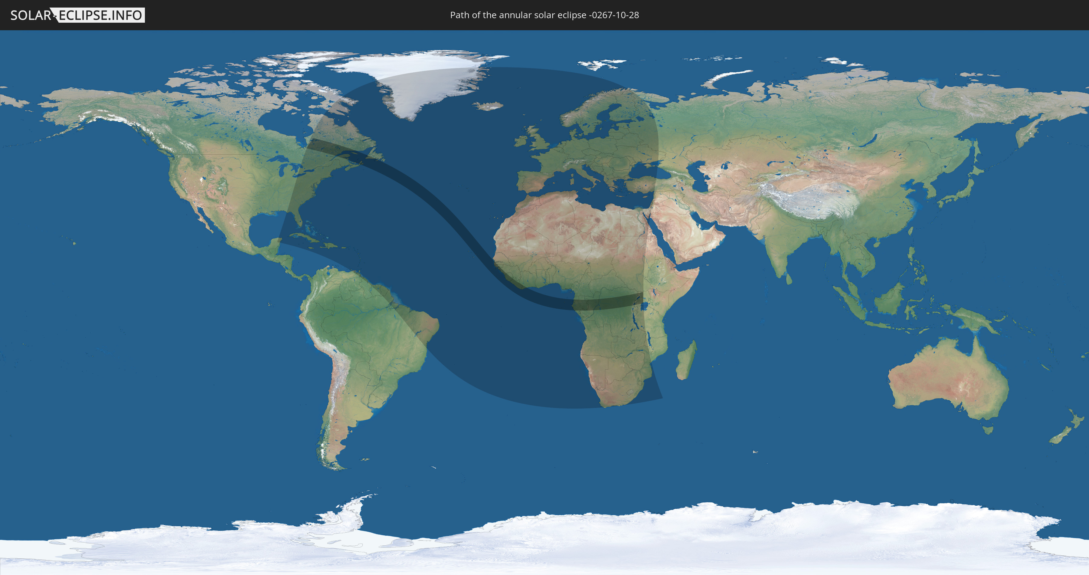
Die Sonnenfinsternis am 10/28/-0267 kann man in 140 Ländern als partielle Sonnenfinsternis beobachten.
Der Finsternispfad verläuft durch 16 Länder. Nur in diesen Ländern ist sie als annular Sonnenfinsternis zu sehen.
In den folgenden Ländern ist die Sonnenfinsternis annular zu sehen
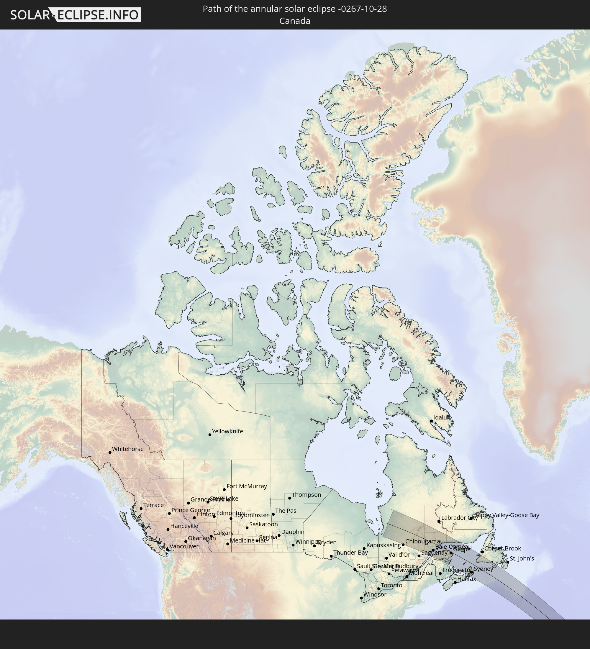 Canada
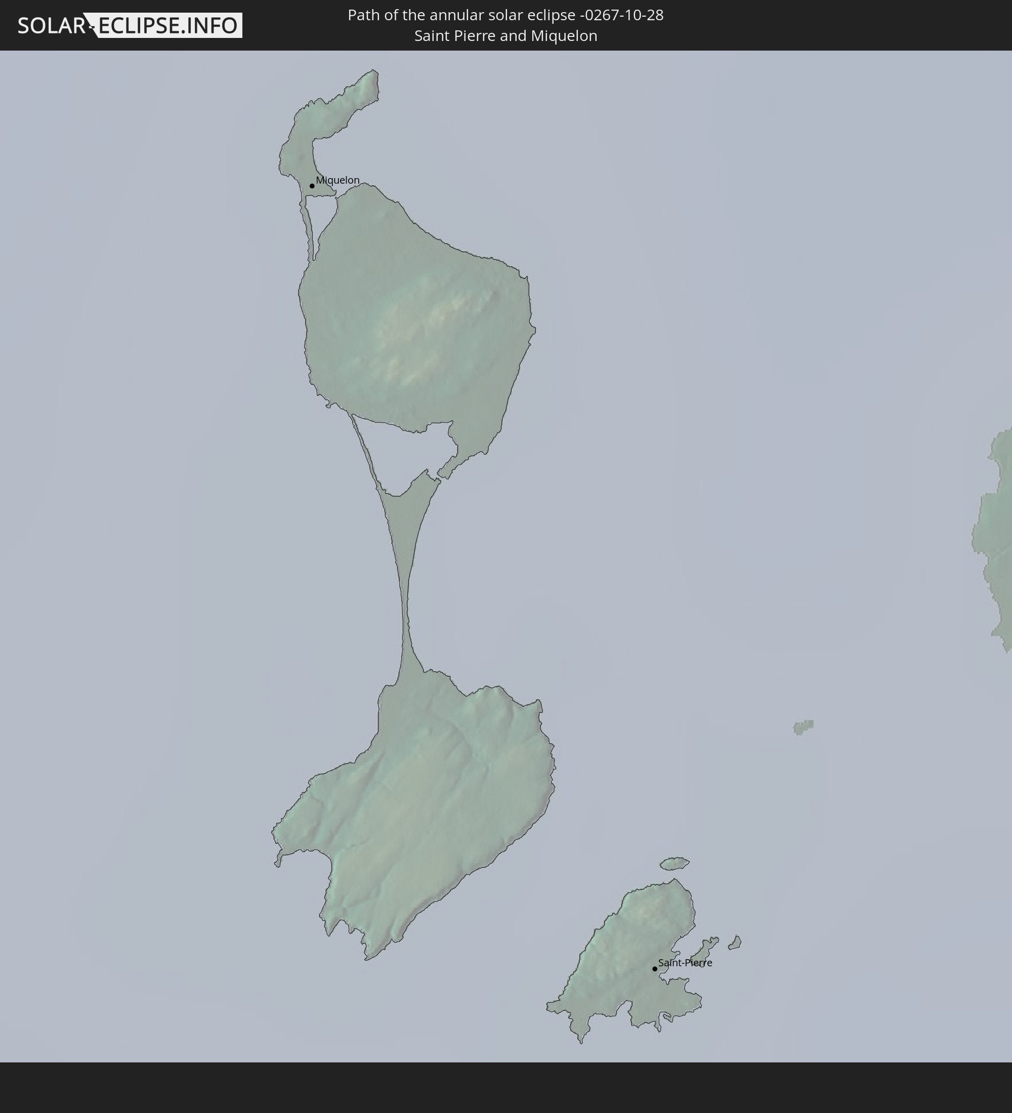 Saint Pierre and Miquelon
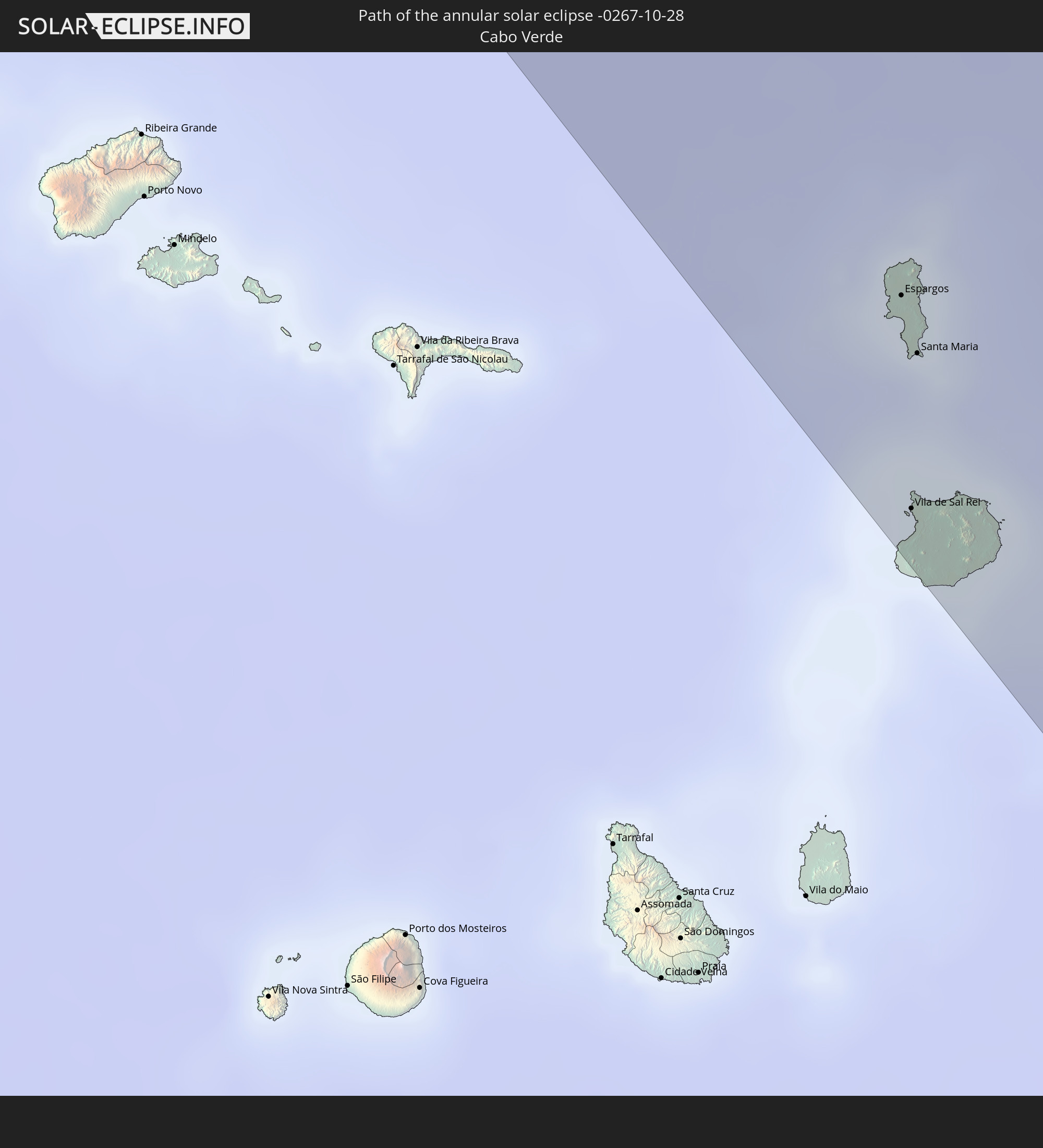 Cabo Verde
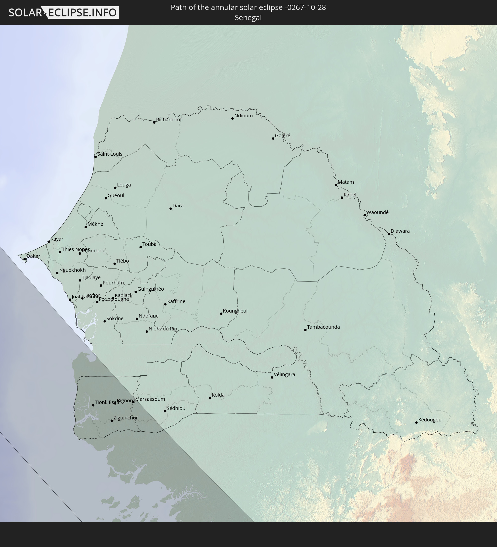 Senegal
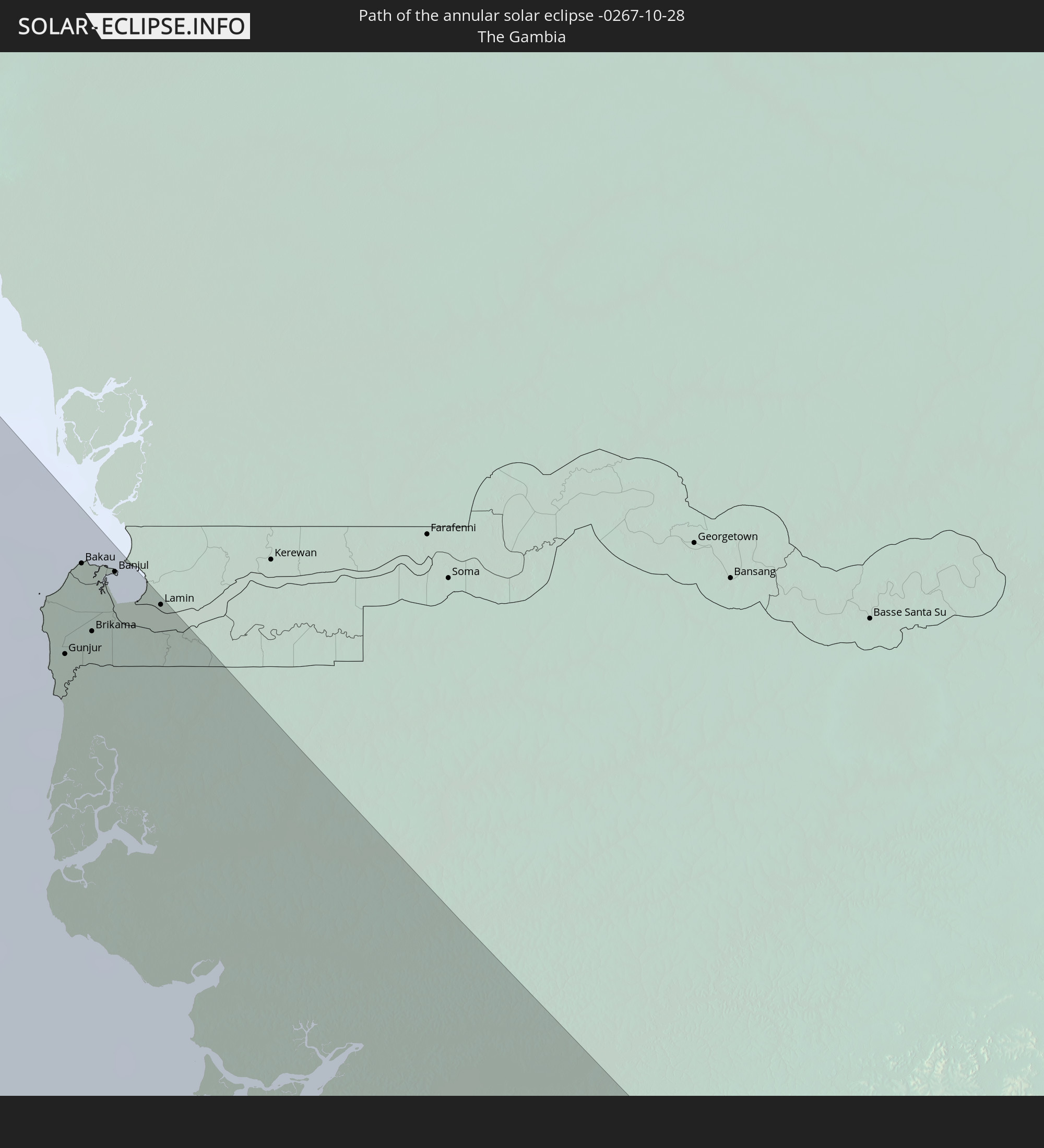 The Gambia
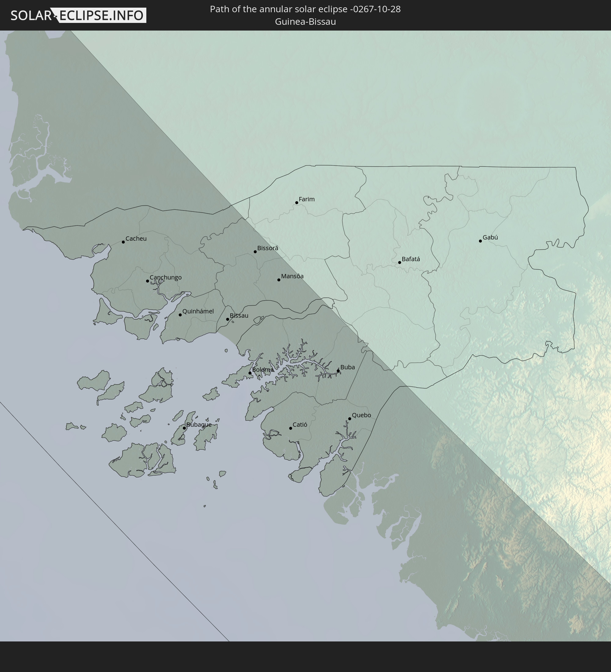 Guinea-Bissau
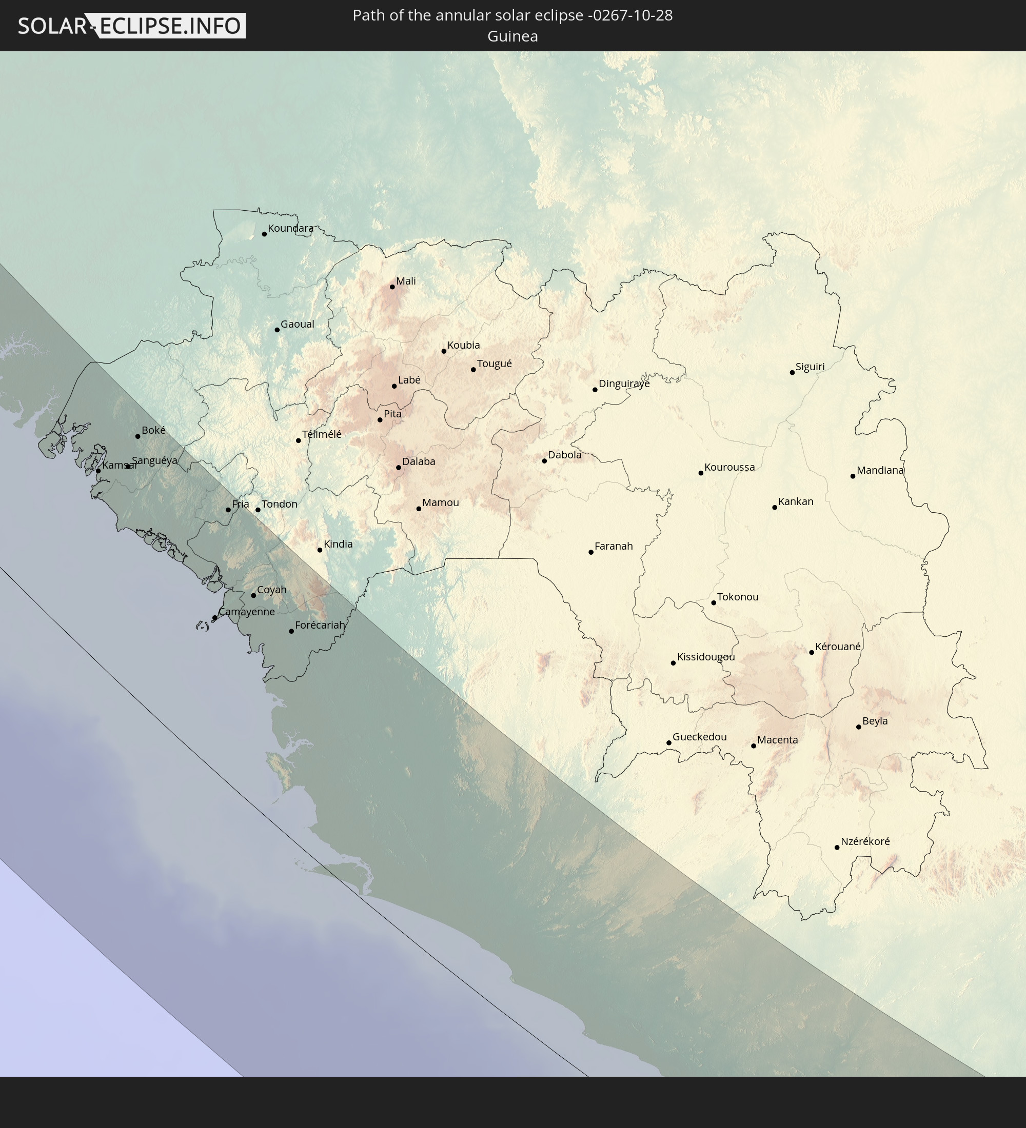 Guinea
 Sierra Leone
 Liberia
 Ivory Coast
 Equatorial Guinea
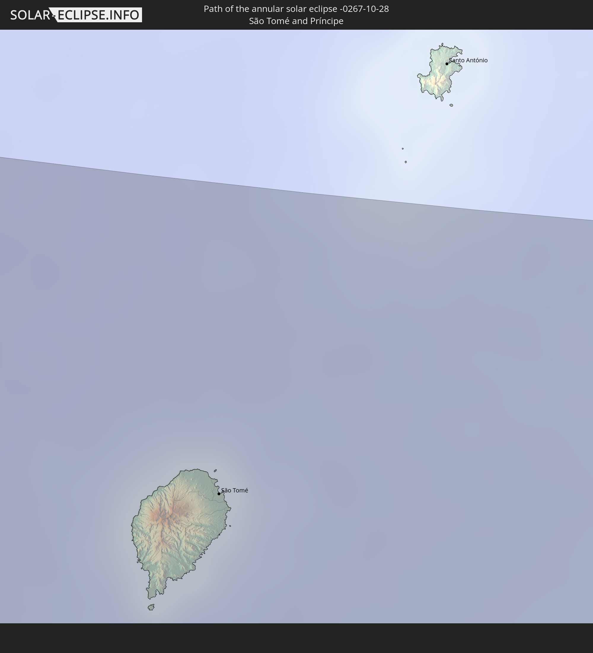 São Tomé and Príncipe
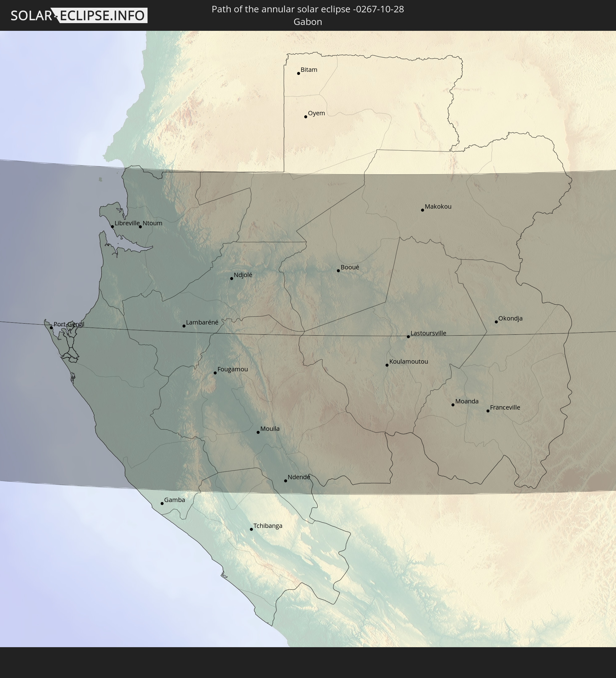 Gabon
Gabon
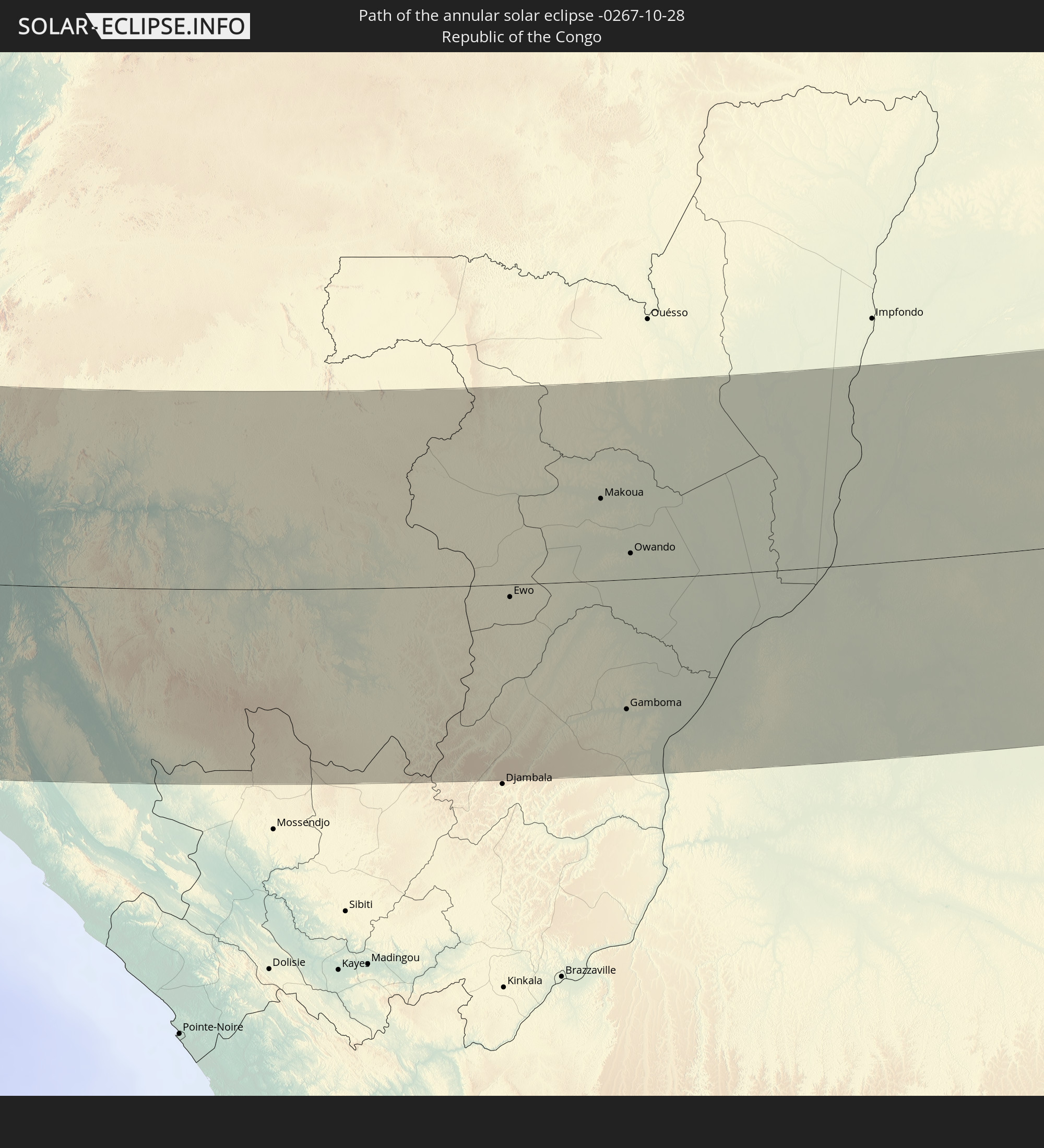 Republic of the Congo
 Democratic Republic of the Congo
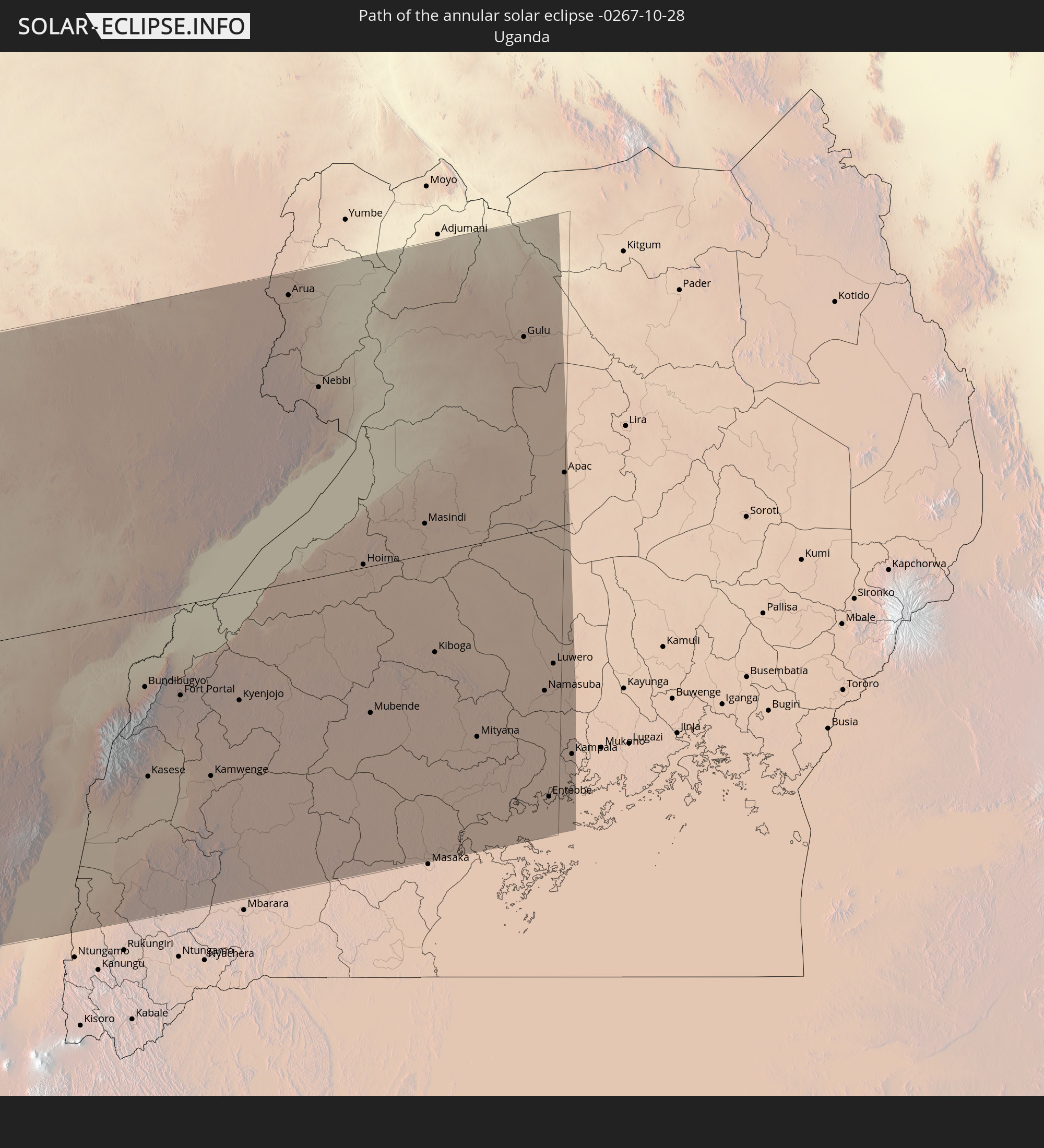 Uganda
In den folgenden Ländern ist die Sonnenfinsternis partiell zu sehen
 Russia
 United States
 United States Minor Outlying Islands
 Canada
 Mexico
 Greenland
 Cuba
Cuba
 Cayman Islands
 The Bahamas
 Jamaica
 Haiti
Haiti
 Brazil
 Venezuela
 Turks and Caicos Islands
 Dominican Republic
 Puerto Rico
 United States Virgin Islands
 Bermuda
 British Virgin Islands
 Anguilla
 Collectivity of Saint Martin
 Saint Barthélemy
 Saint Kitts and Nevis
 Antigua and Barbuda
 Montserrat
 Trinidad and Tobago
 Guadeloupe
 Grenada
 Dominica
 Saint Vincent and the Grenadines
 Guyana
 Martinique
 Saint Lucia
 Barbados
 Suriname
 Saint Pierre and Miquelon
 French Guiana
 Portugal
 Cabo Verde
 Iceland
 Spain
Spain
 Senegal
 Mauritania
 The Gambia
 Guinea-Bissau
 Guinea
 Saint Helena, Ascension and Tristan da Cunha
 Sierra Leone
 Morocco
 Mali
Mali
 Liberia
 Republic of Ireland
 Svalbard and Jan Mayen
 Algeria
 United Kingdom
 Ivory Coast
 Faroe Islands
 Burkina Faso
 Gibraltar
 France
 Isle of Man
 Ghana
Ghana
 Guernsey
 Jersey
 Togo
Togo
 Niger
Niger
 Benin
Benin
 Andorra
 Belgium
 Nigeria
 Netherlands
 Norway
 Equatorial Guinea
 Luxembourg
 Germany
 Switzerland
 São Tomé and Príncipe
 Italy
Italy
 Monaco
 Tunisia
 Denmark
 Cameroon
 Gabon
Gabon
 Libya
Libya
 Liechtenstein
 Austria
 Sweden
 Republic of the Congo
 Angola
 Namibia
 Czechia
 Democratic Republic of the Congo
 San Marino
 Vatican City
 Slovenia
 Chad
Chad
 Croatia
 Poland
 Malta
Malta
 Central African Republic
 Bosnia and Herzegovina
 Hungary
 South Africa
 Slovakia
 Montenegro
 Serbia
 Albania
 Åland Islands
 Greece
 Botswana
 Romania
 Republic of Macedonia
 Finland
 Lithuania
 Latvia
 Estonia
 Sudan
Sudan
 Zambia
 Ukraine
 Bulgaria
 Belarus
 Egypt
Egypt
 Zimbabwe
 Turkey
 Moldova
 Lesotho
 Rwanda
 Burundi
 Tanzania
 Uganda
 Mozambique
 Swaziland
 Cyprus
 Malawi
 State of Palestine
 Israel
 Saudi Arabia
 Jordan
 Lebanon
 Syria
Syria
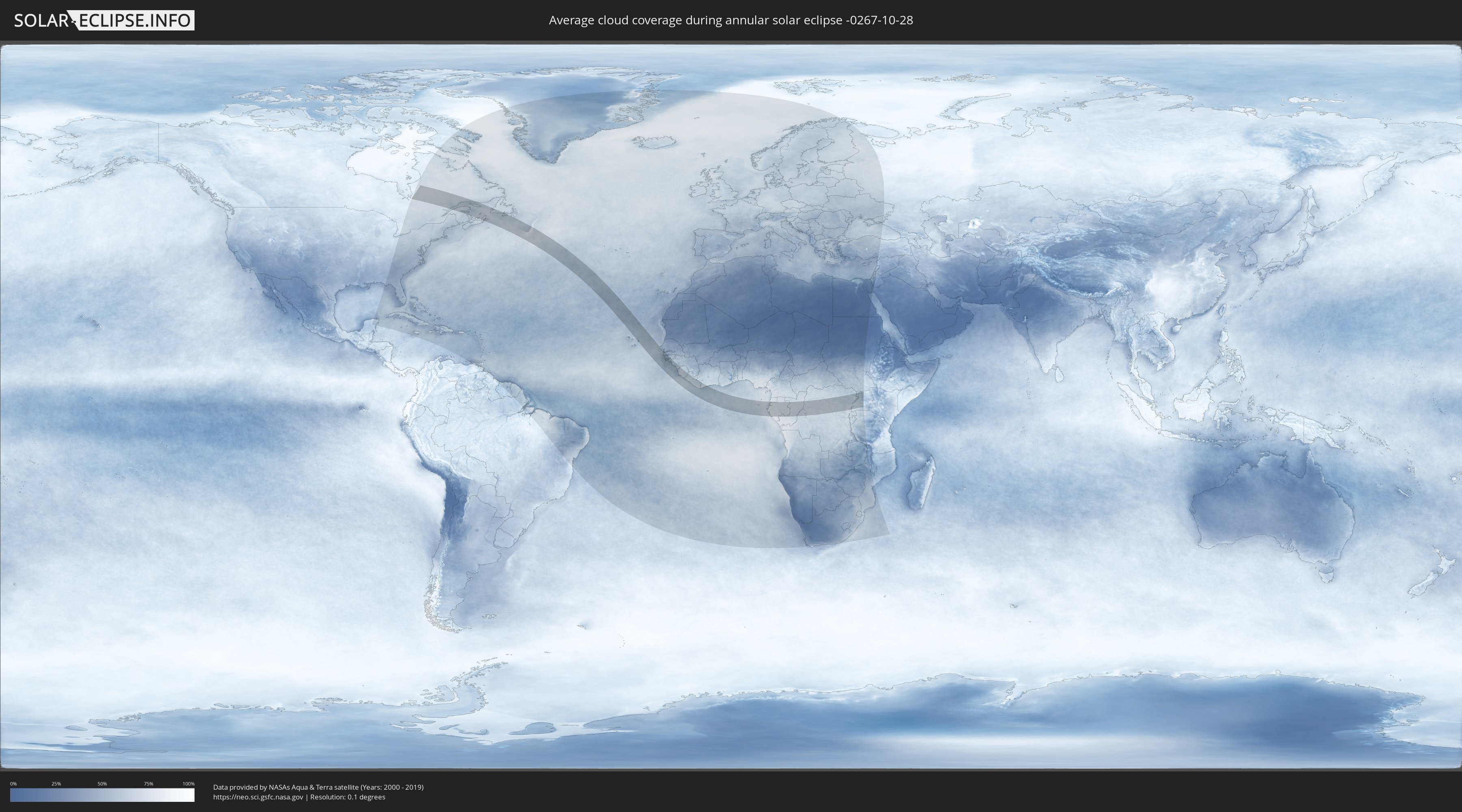
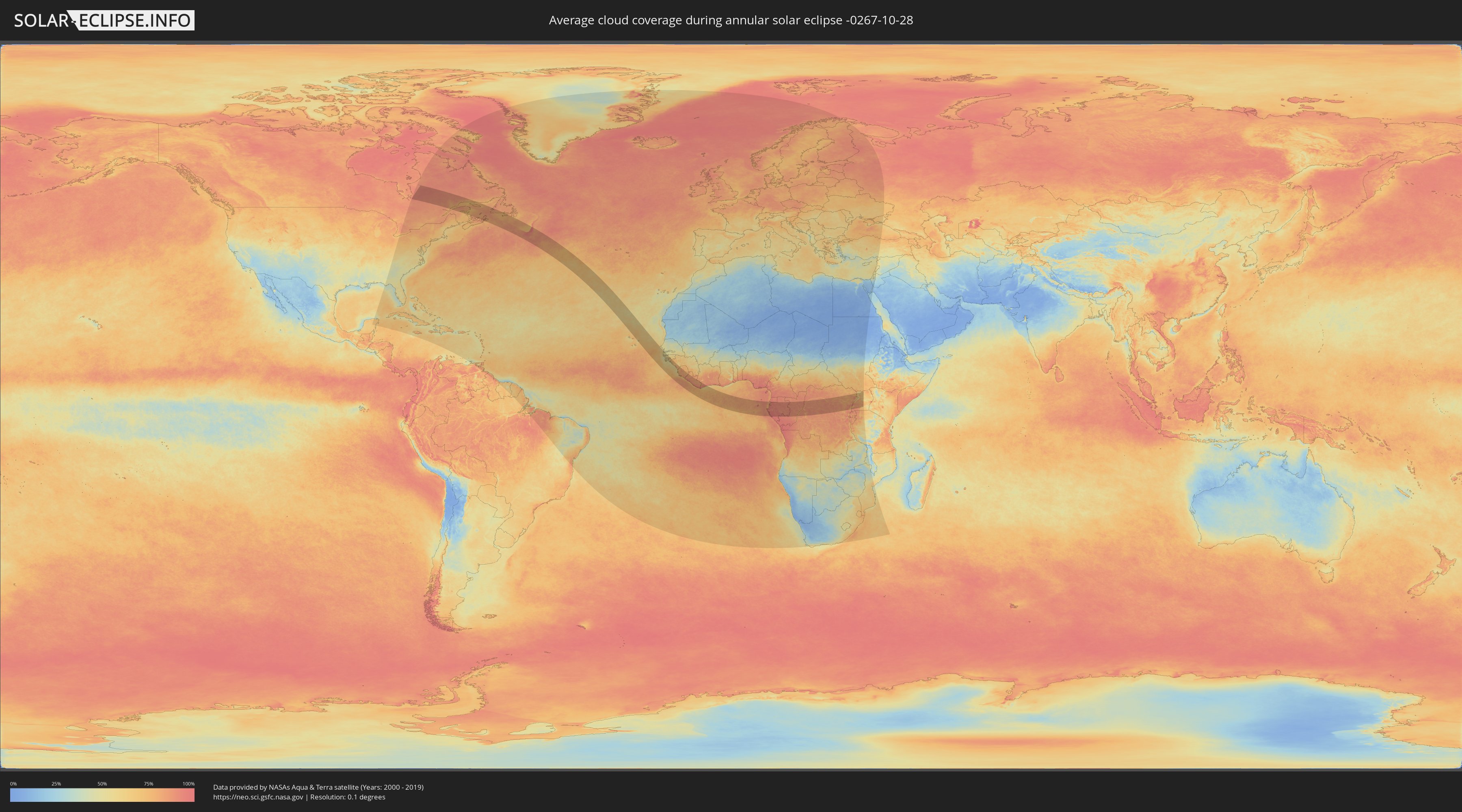
How will be the weather during the annular solar eclipse on 10/28/-0267?
Where is the best place to see the annular solar eclipse of 10/28/-0267?
The following maps show the average cloud coverage for the day of the annular solar eclipse.
With the help of these maps, it is possible to find the place along the eclipse path, which has the best
chance of a cloudless sky.
Nevertheless, you should consider local circumstances and inform about the weather of your chosen
observation site.
The data is provided by NASAs satellites
AQUA and TERRA.
The cloud maps are averaged over a period of 19 years (2000 - 2019).
Detailed country maps
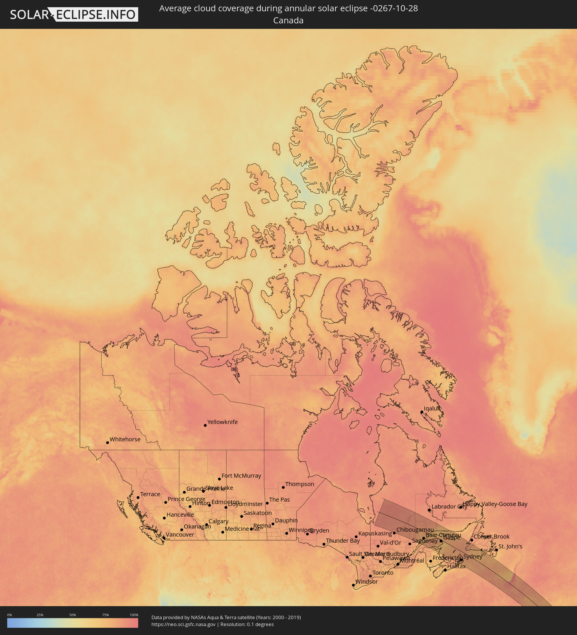 Canada
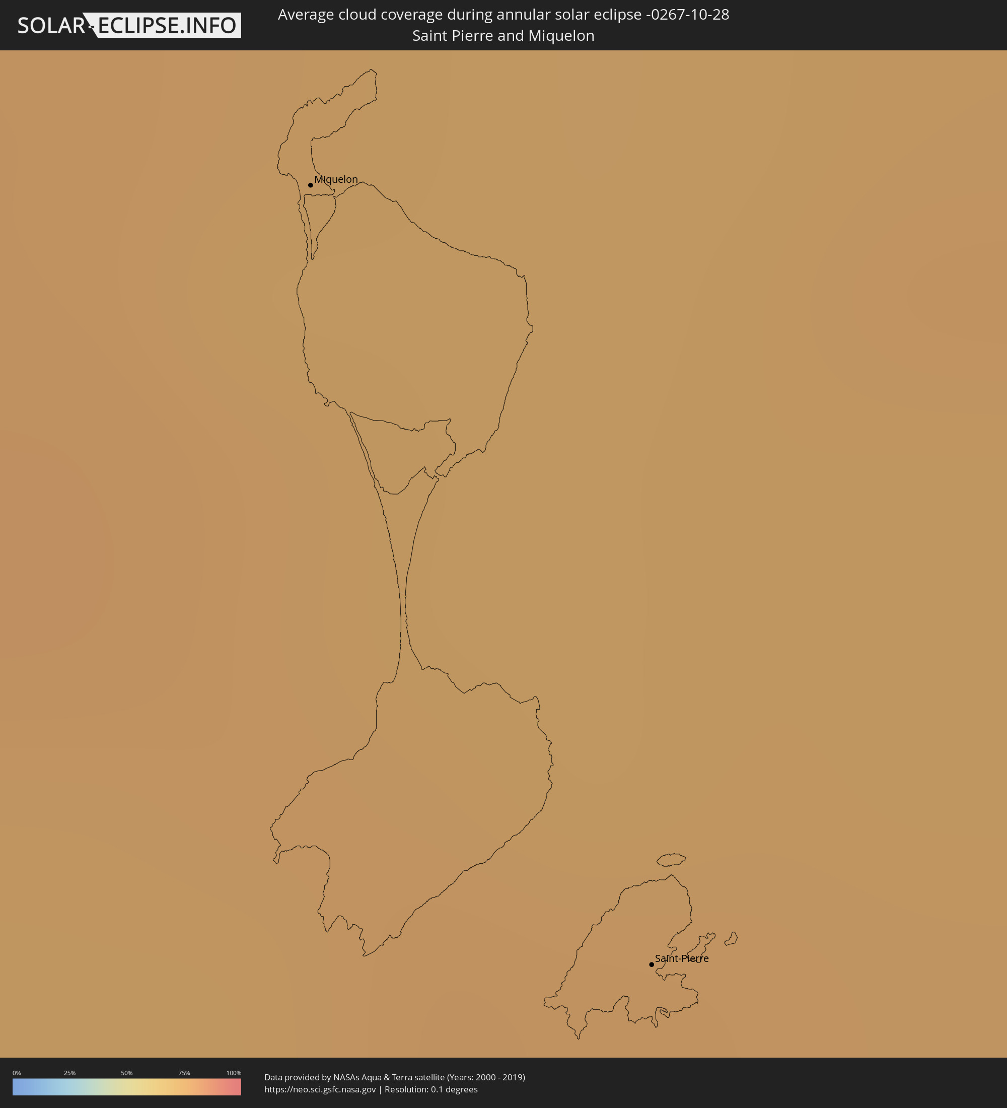 Saint Pierre and Miquelon
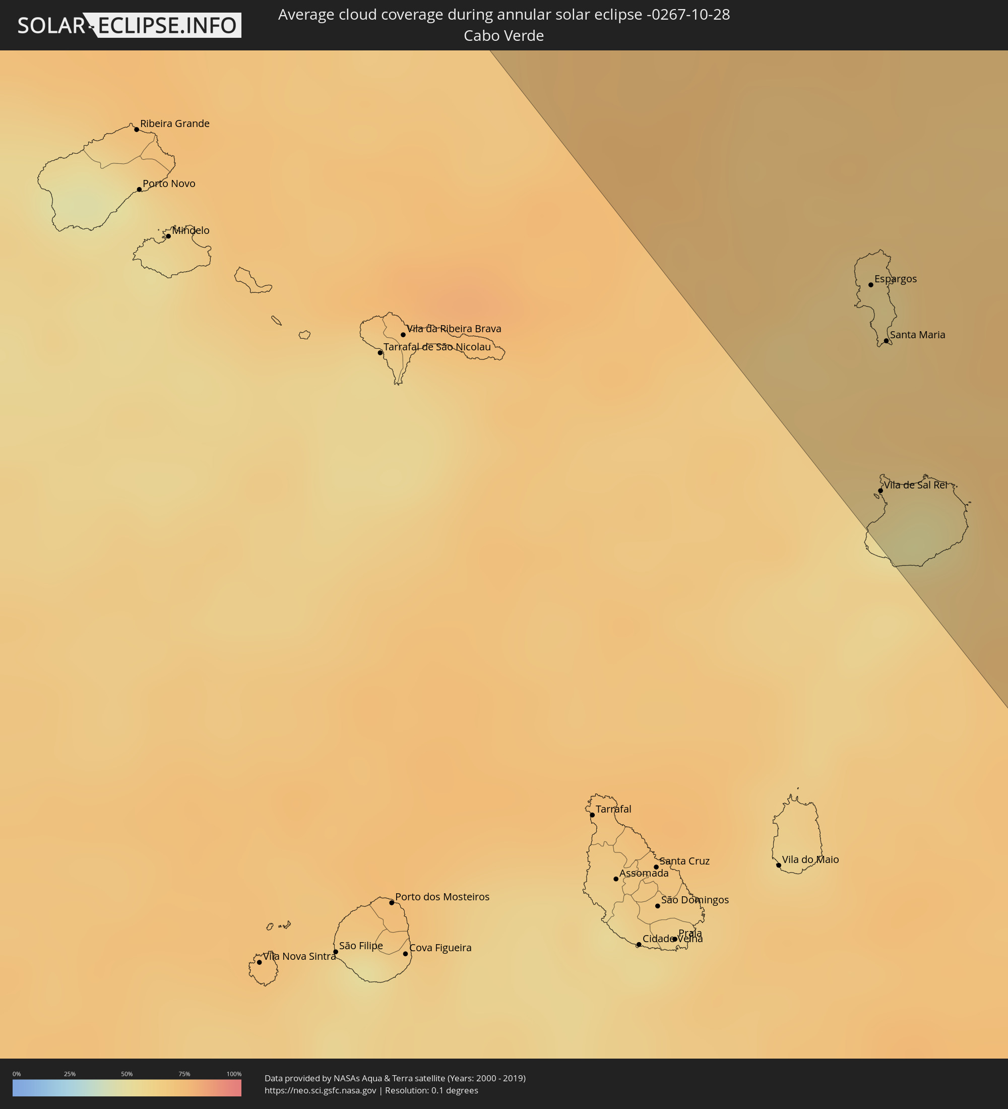 Cabo Verde
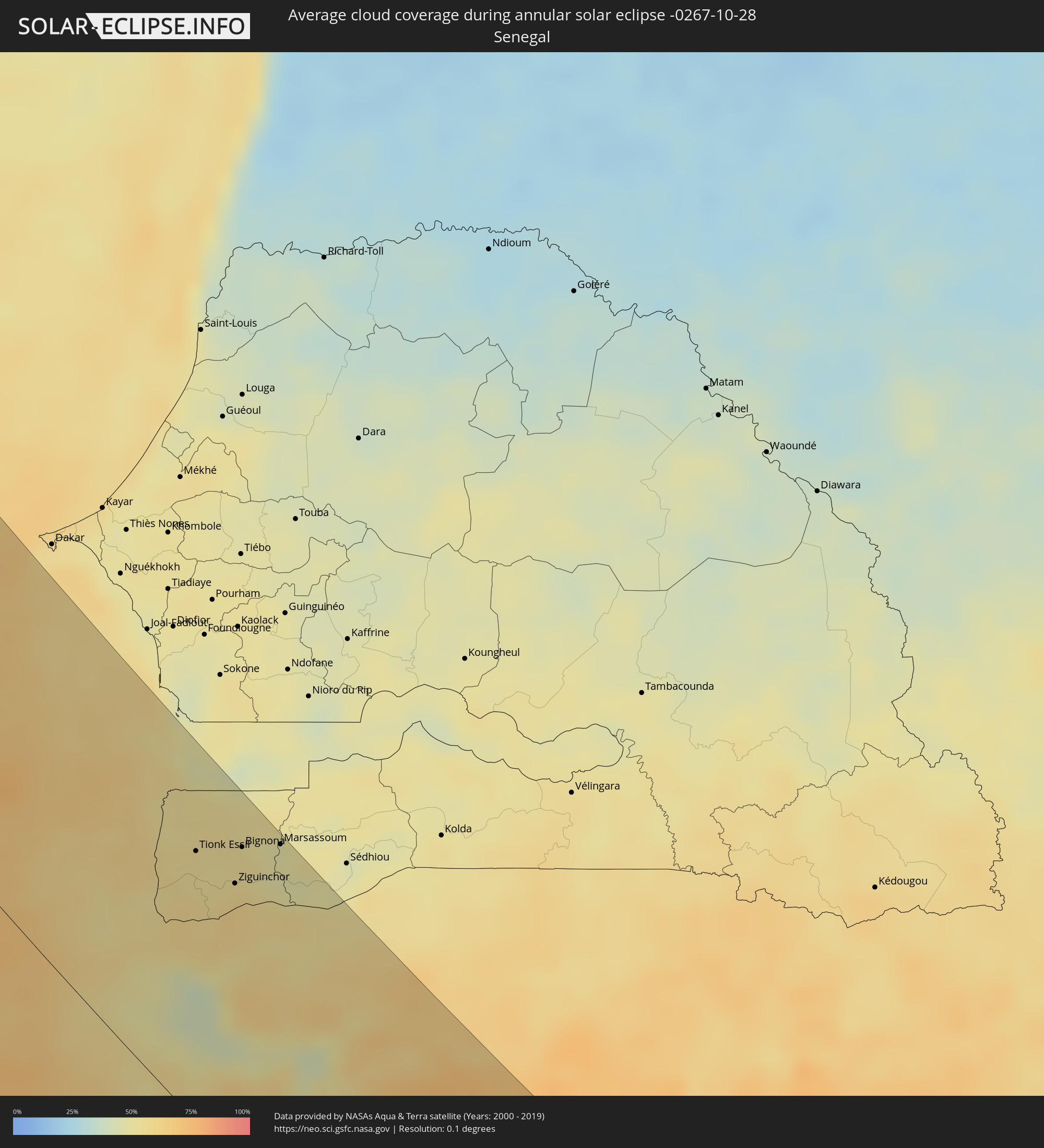 Senegal
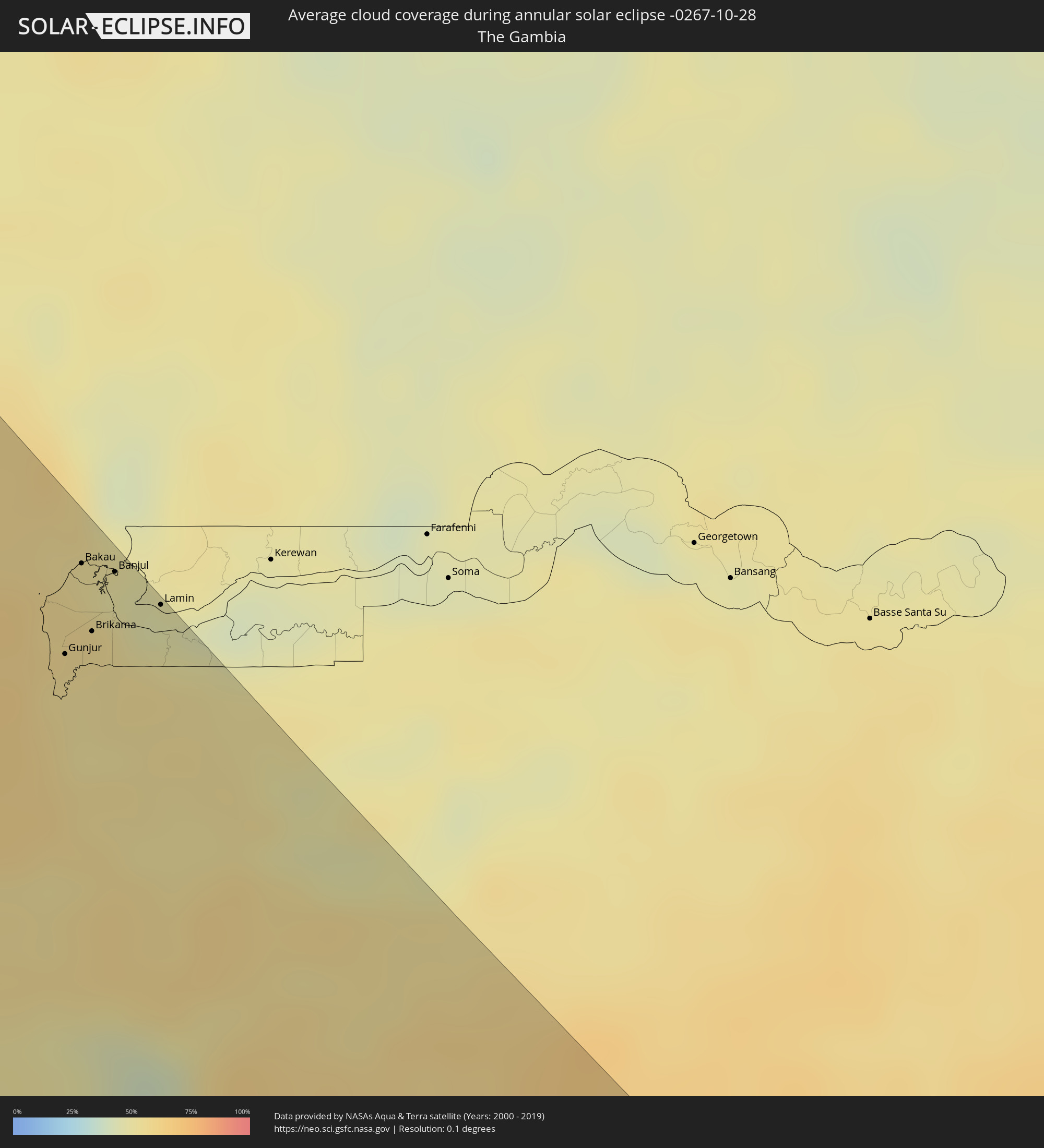 The Gambia
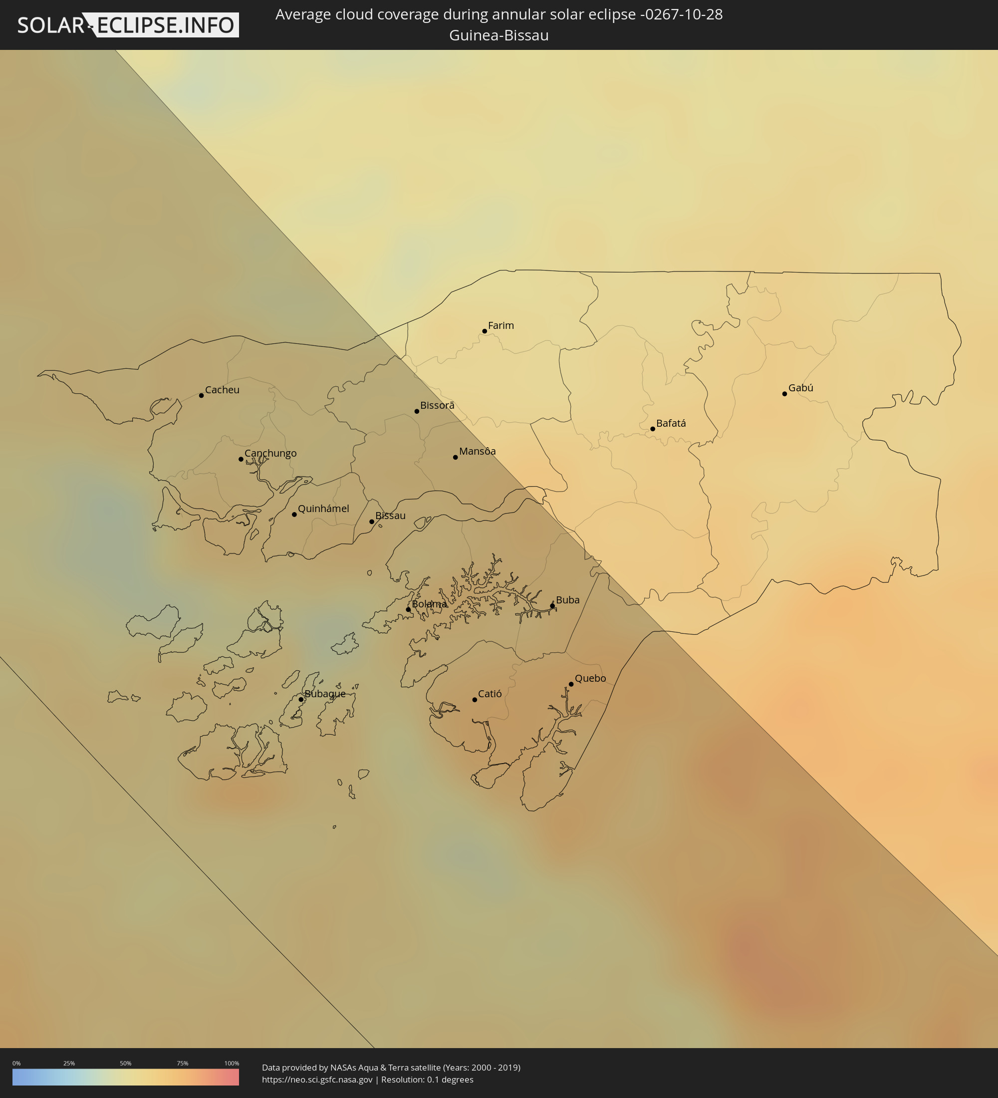 Guinea-Bissau
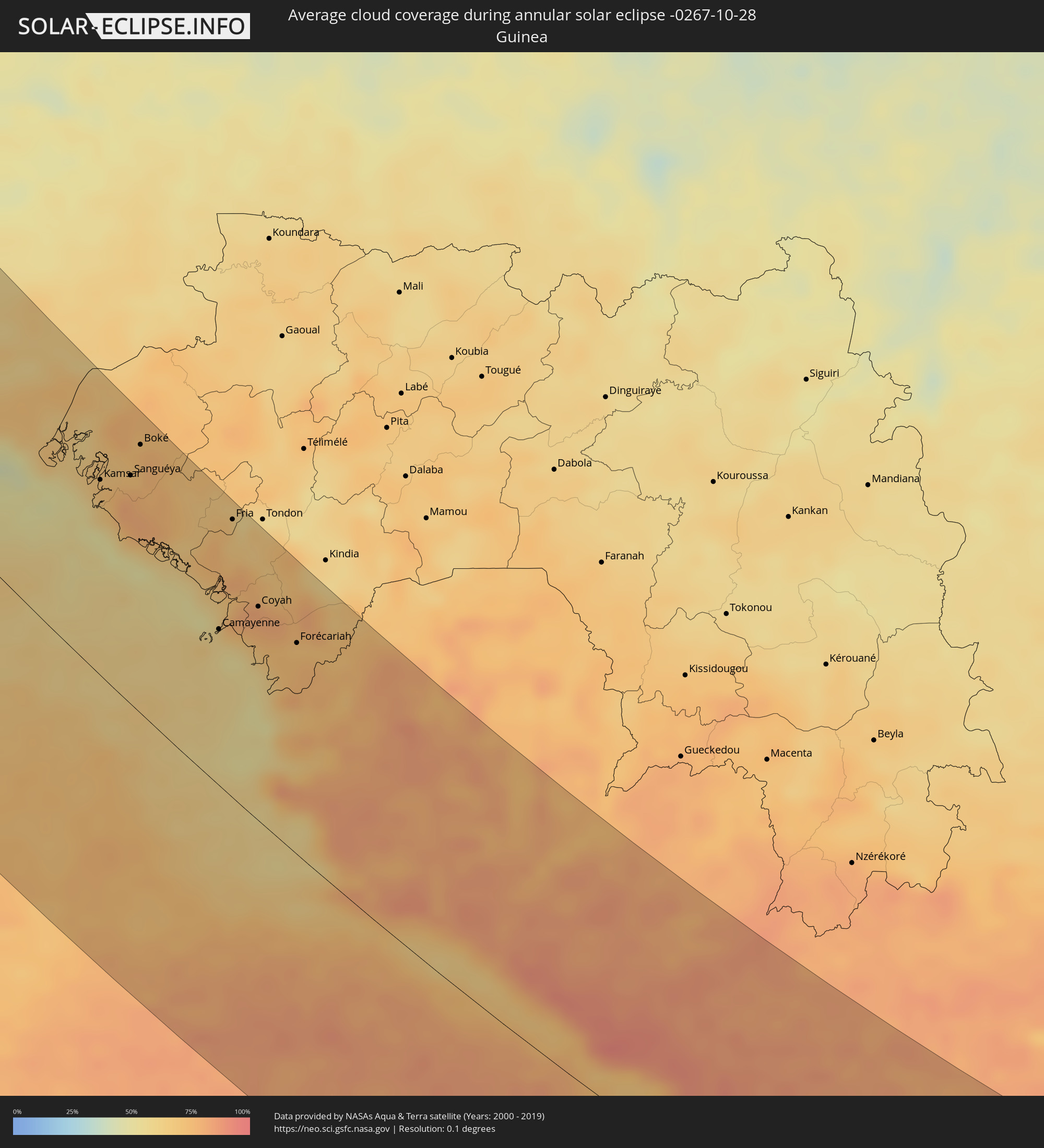 Guinea
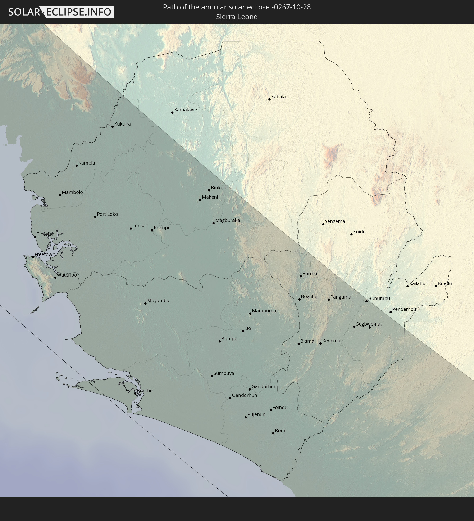
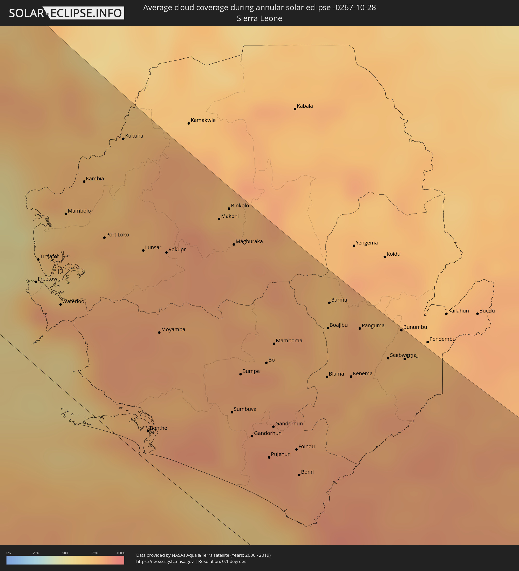 Sierra Leone
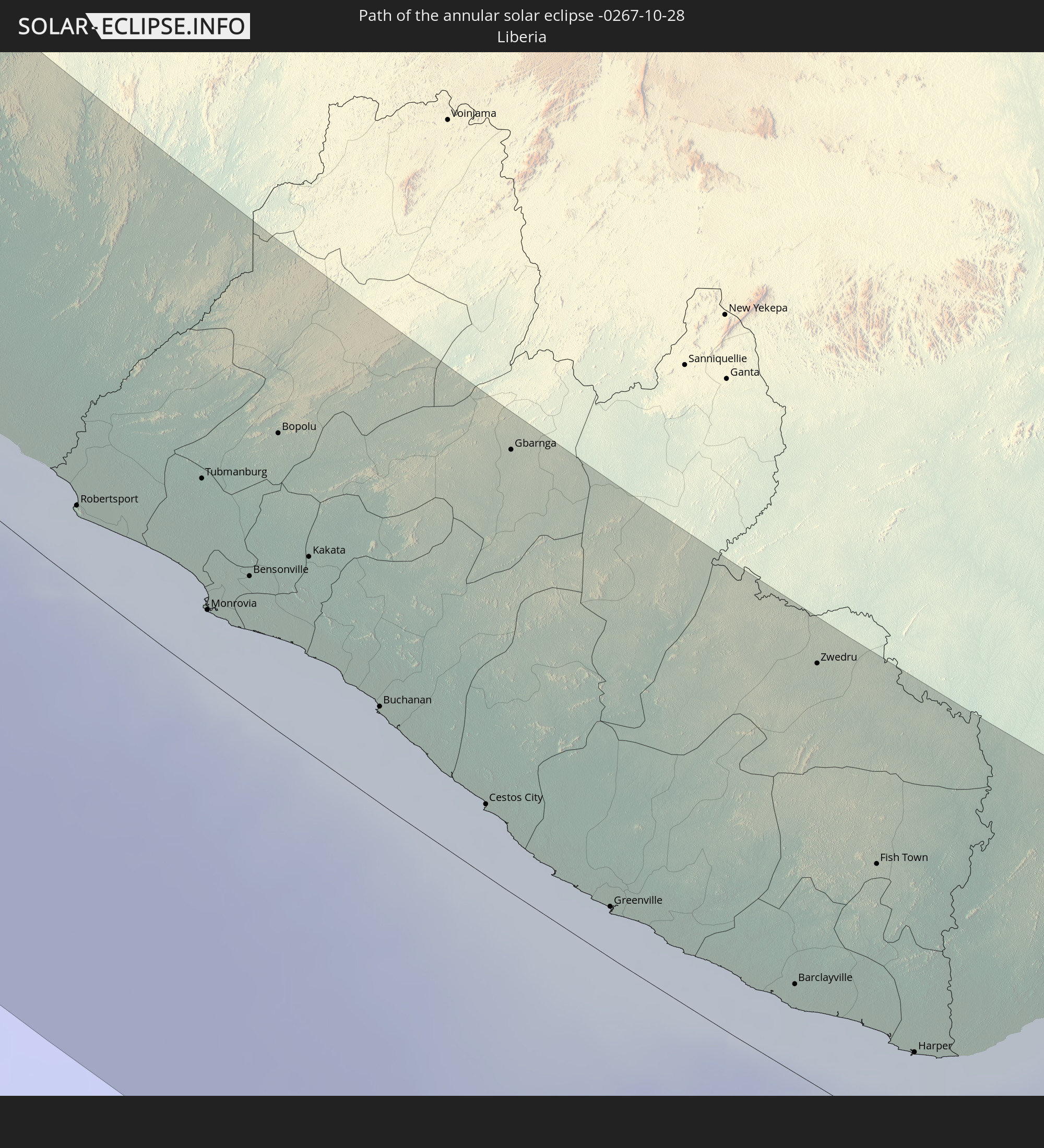
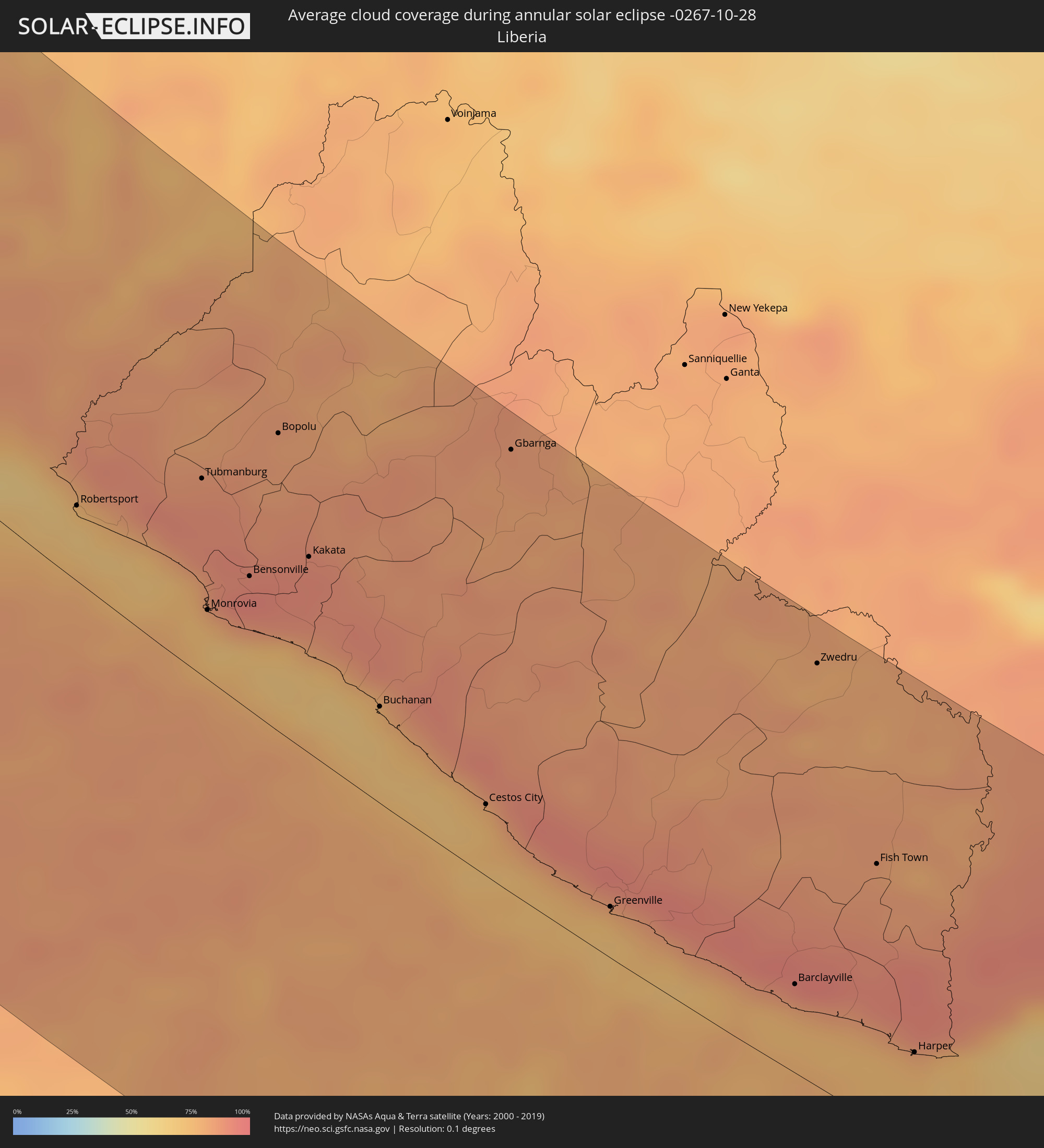 Liberia
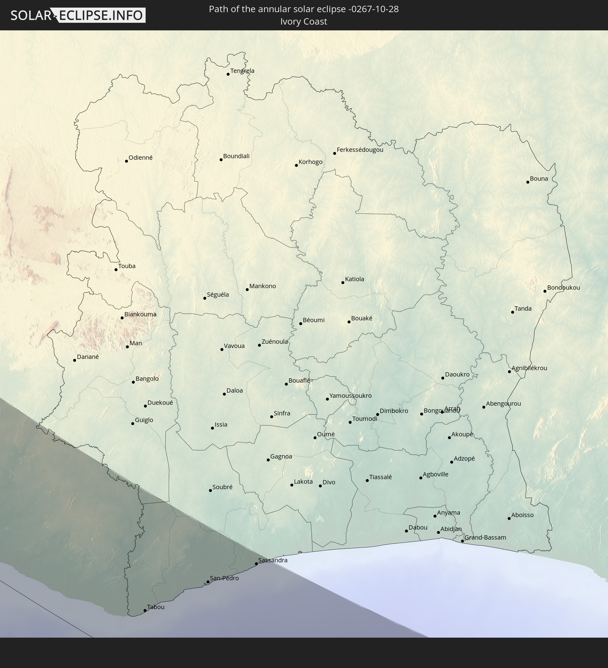
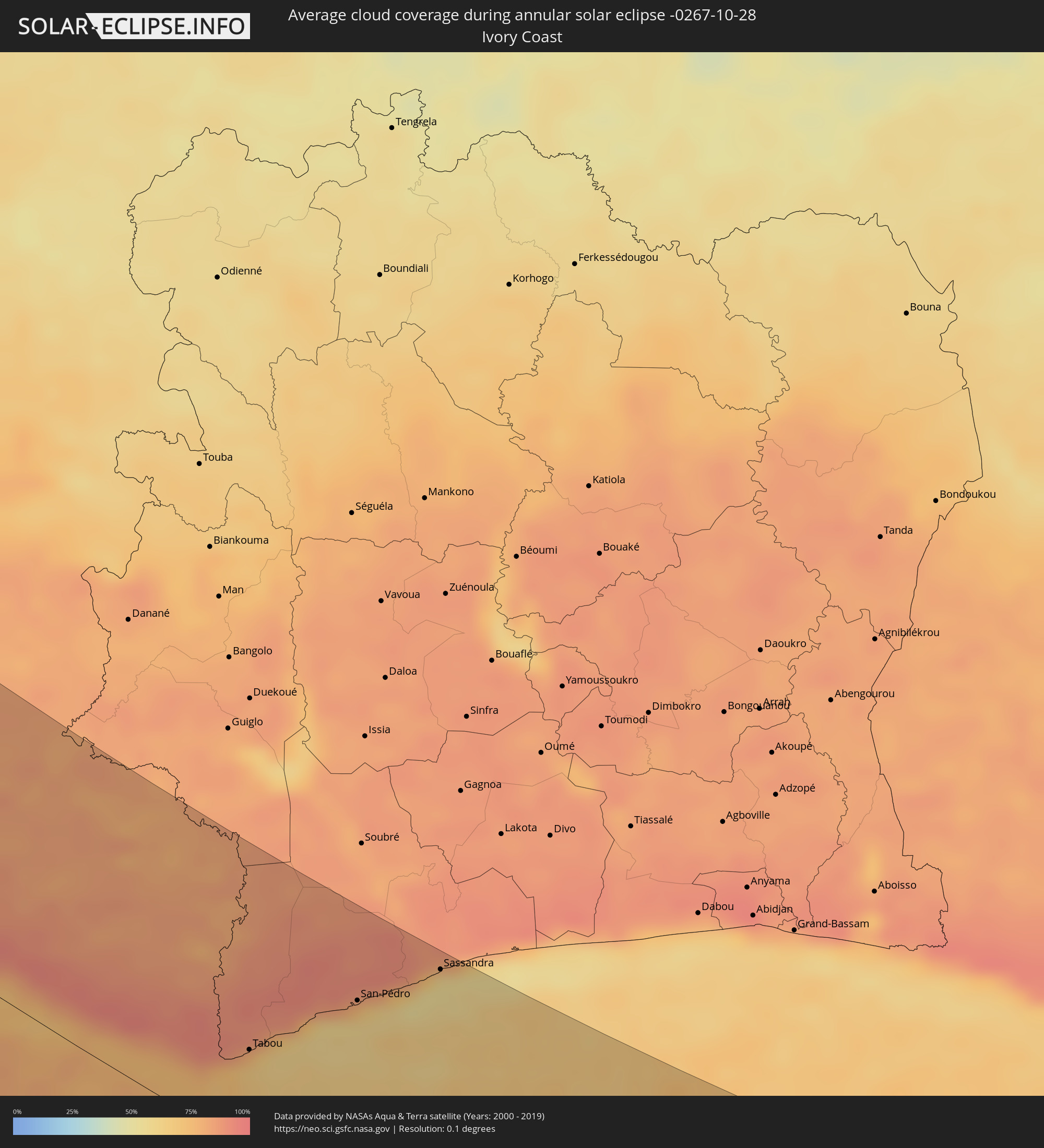 Ivory Coast
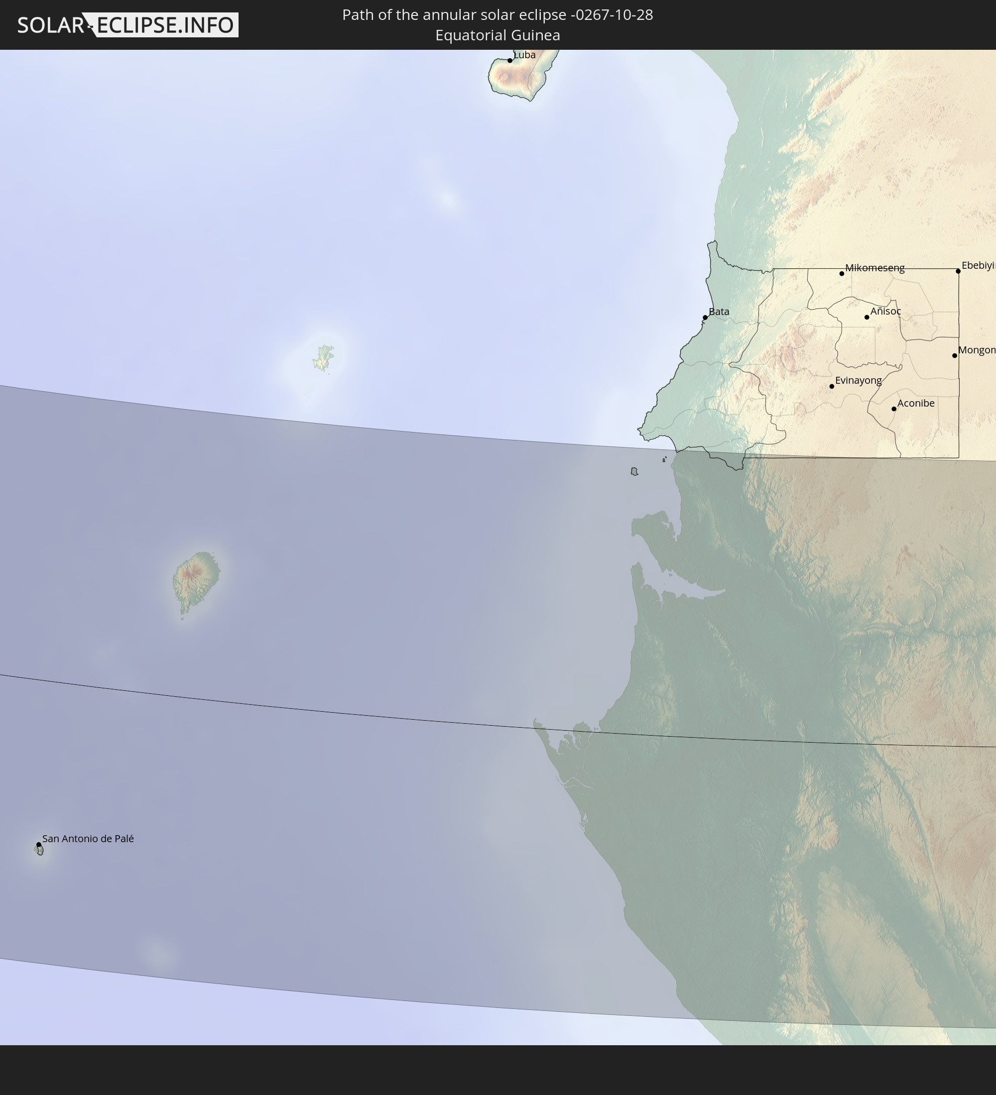
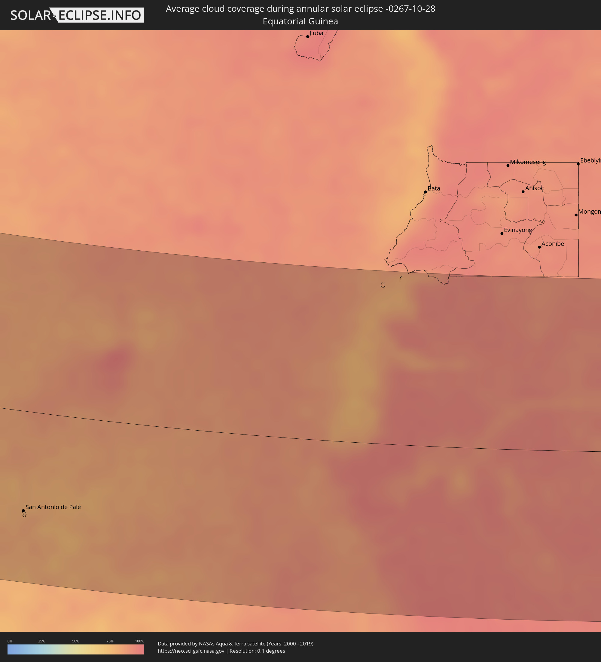 Equatorial Guinea
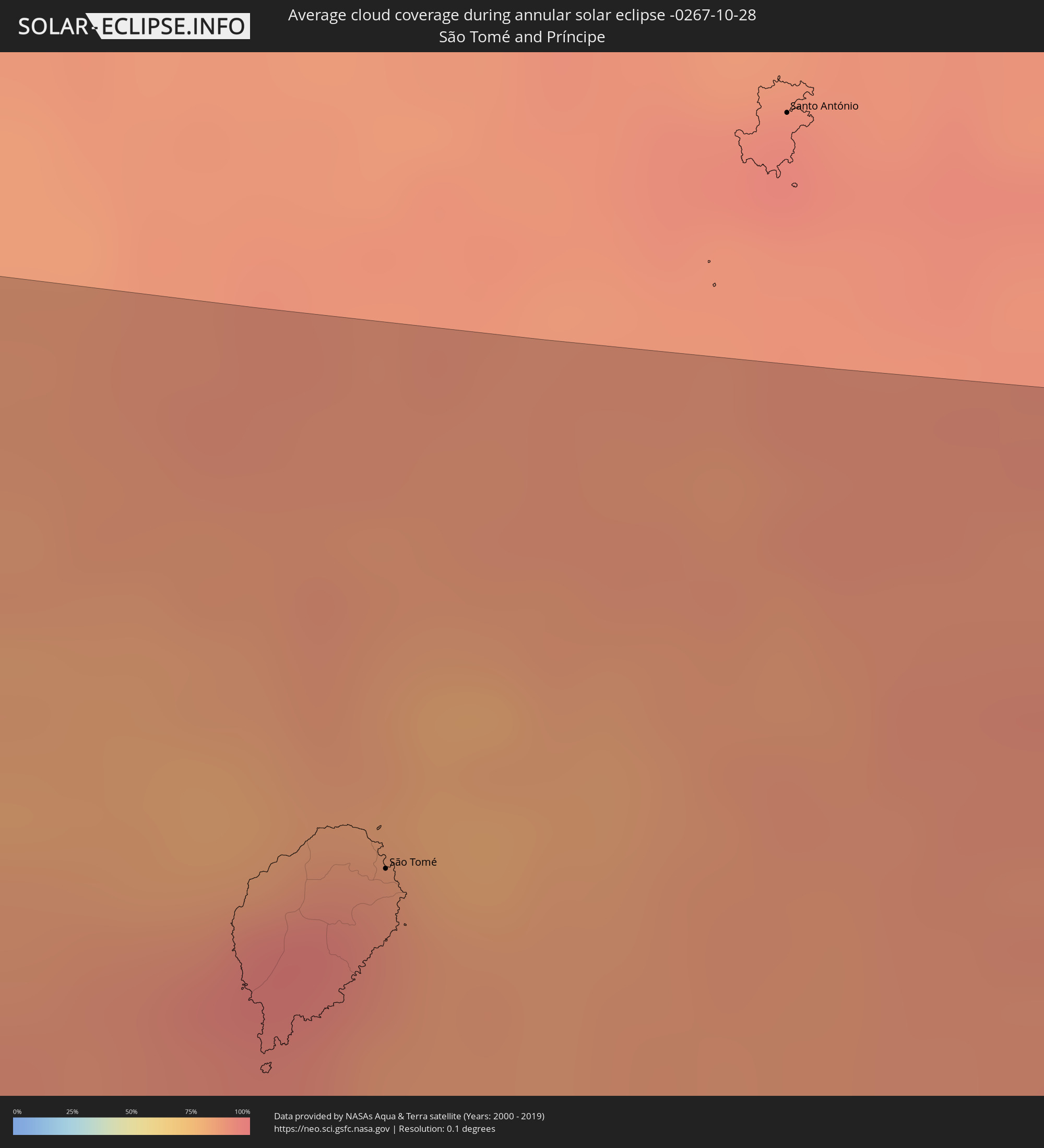 São Tomé and Príncipe
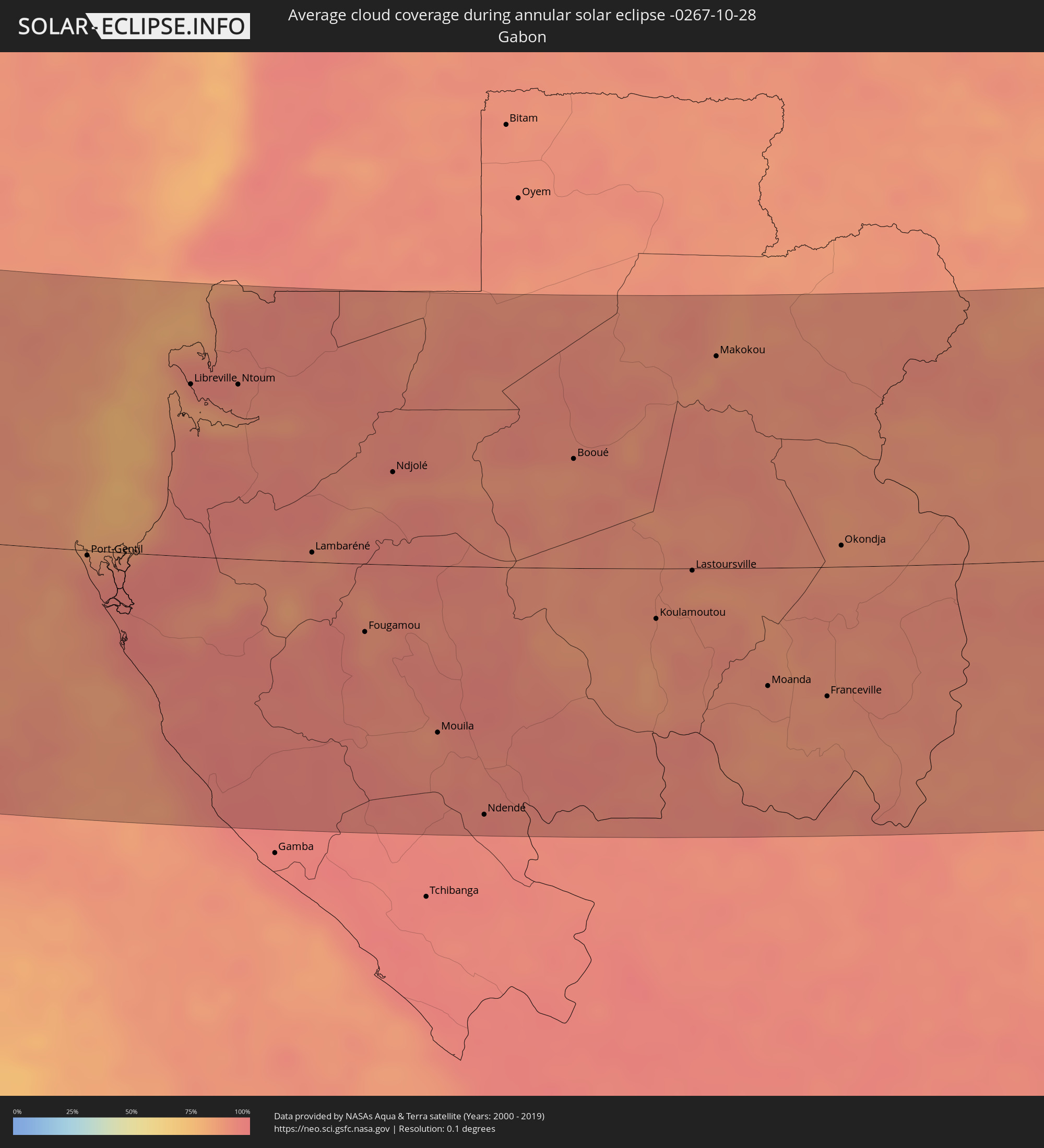 Gabon
Gabon
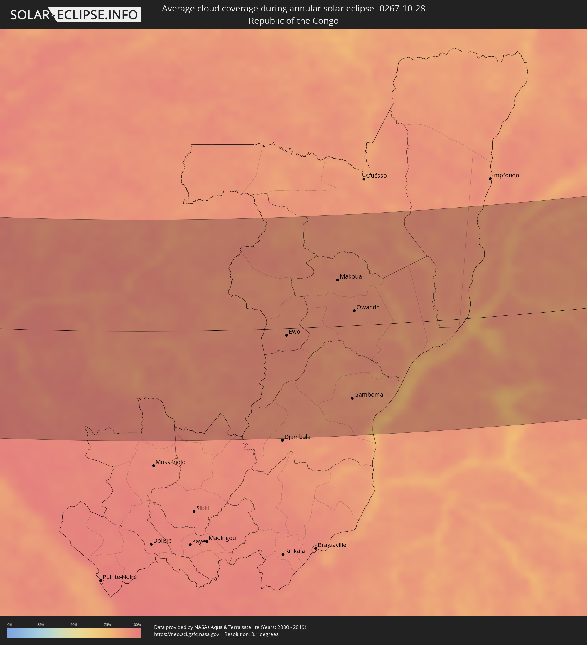 Republic of the Congo
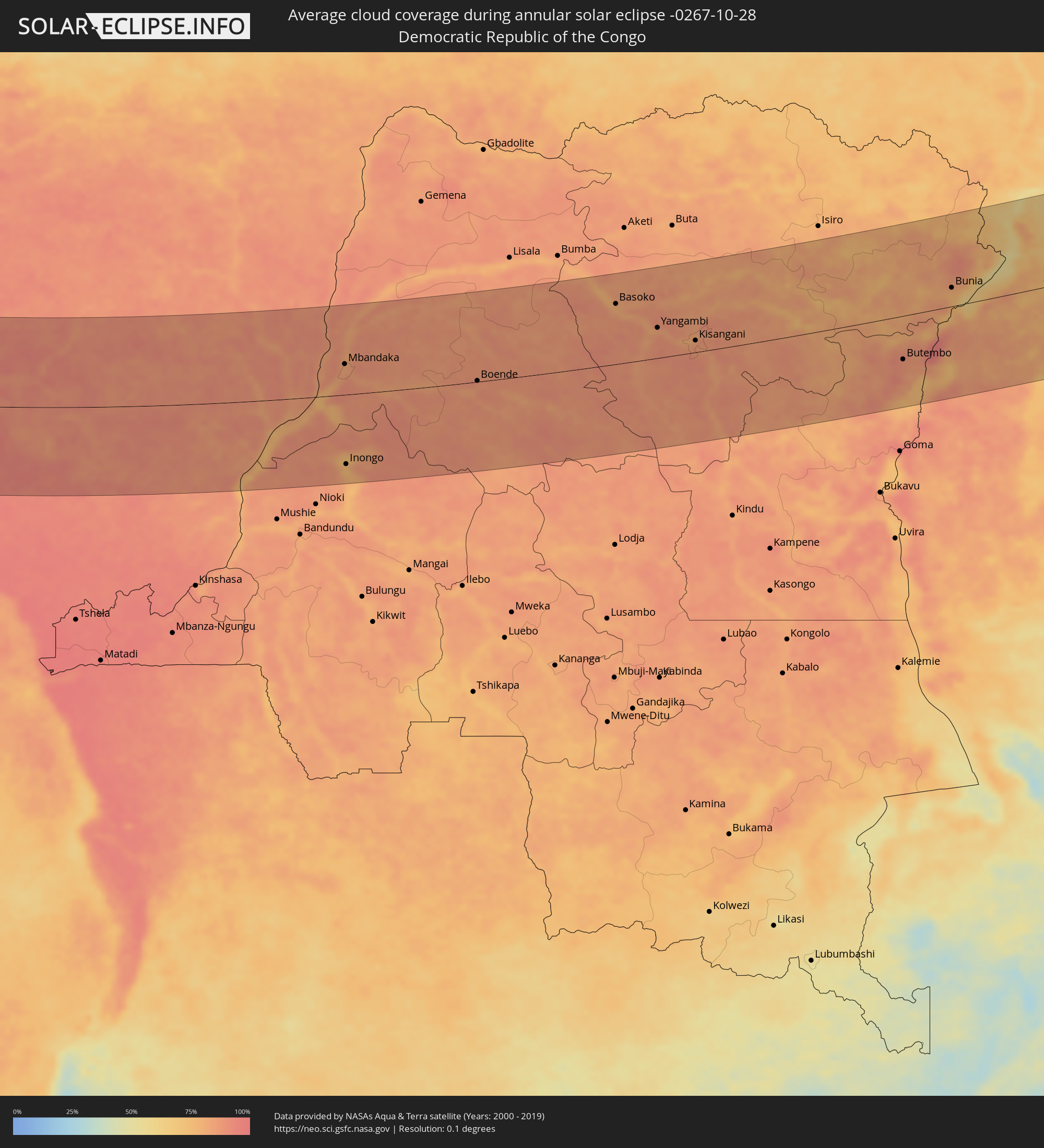 Democratic Republic of the Congo
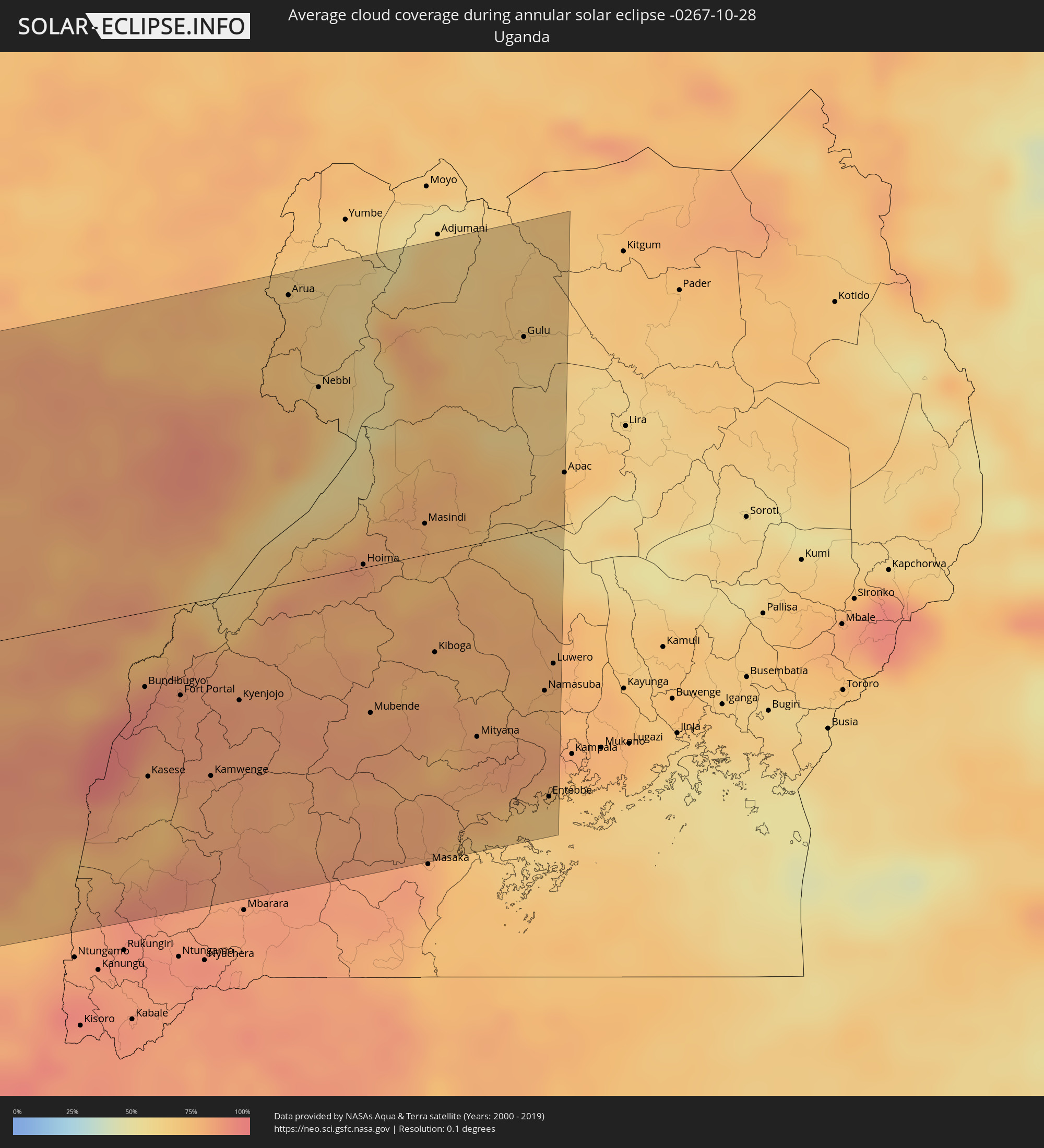 Uganda
Cities inside the path of the eclipse
The following table shows all locations with a population of more than 5,000 inside the eclipse path. Cities which have more than 100,000 inhabitants are marked bold. A click at the locations opens a detailed map.
| City | Type | Eclipse duration | Local time of max. eclipse | Distance to central line | Ø Cloud coverage |
|
Rimouski, Quebec
|
annular | - | 07:05:01 UTC-05:00 | 186 km | 82% |
|
Mont-Joli, Quebec
|
annular | - | 07:05:14 UTC-05:00 | 162 km | 79% |
|
Baie-Comeau, Quebec
|
annular | - | 07:05:35 UTC-05:00 | 97 km | 77% |
|
Matane, Quebec
|
annular | - | 07:05:38 UTC-05:00 | 116 km | 84% |
|
Campbellton, New Brunswick
|
annular | - | 07:51:11 UTC-04:14 | 170 km | 80% |
|
Sept-Îles, Quebec
|
annular | - | 07:06:52 UTC-05:00 | 57 km | 77% |
|
Bathurst, New Brunswick
|
annular | - | 07:51:29 UTC-04:14 | 175 km | 74% |
|
Chandler, Quebec
|
annular | - | 07:06:41 UTC-05:00 | 69 km | 74% |
|
Gaspé, Quebec
|
annular | - | 07:07:01 UTC-05:00 | 15 km | 78% |
|
Sydney Mines, Nova Scotia
|
annular | - | 07:53:55 UTC-04:14 | 112 km | 82% |
|
Sydney, Nova Scotia
|
annular | - | 07:53:54 UTC-04:14 | 120 km | 81% |
|
Glace Bay, Nova Scotia
|
annular | - | 07:54:04 UTC-04:14 | 105 km | 82% |
|
Stephenville, Newfoundland and Labrador
|
annular | - | 08:39:16 UTC-03:30 | 173 km | 84% |
|
Miquelon, Miquelon-Langlade
|
annular | - | 08:26:25 UTC-03:44 | 123 km | 75% |
|
Saint-Pierre, Saint-Pierre
|
annular | - | 08:26:28 UTC-03:44 | 102 km | 75% |
|
Espargos, Sal
|
annular | - | 11:56:39 UTC-01:34 | 121 km | 57% |
|
Vila de Sal Rei, Boa Vista
|
annular | - | 11:58:02 UTC-01:34 | 159 km | 56% |
|
Santa Maria, Sal
|
annular | - | 11:57:07 UTC-01:34 | 128 km | 64% |
|
Gunjur, Western
|
annular | - | 13:38:00 UTC-00:16 | 141 km | 54% |
|
Sukuta, Western
|
annular | - | 13:37:33 UTC-00:16 | 159 km | 57% |
|
Bakau, Banjul
|
annular | - | 13:37:27 UTC-00:16 | 166 km | 54% |
|
Abuko, Western
|
annular | - | 13:37:42 UTC-00:16 | 162 km | 57% |
|
Brikama, Western
|
annular | - | 13:38:03 UTC-00:16 | 153 km | 54% |
|
Banjul, Banjul
|
annular | - | 13:37:47 UTC-00:16 | 172 km | 49% |
|
Barra, North Bank
|
annular | - | 13:37:47 UTC-00:16 | 177 km | 47% |
|
Essau, North Bank
|
annular | - | 13:37:49 UTC-00:16 | 178 km | 47% |
|
Tionk Essil, Ziguinchor
|
annular | - | 13:39:33 UTC-00:16 | 128 km | 54% |
|
Lamin, North Bank
|
annular | - | 13:38:23 UTC-00:16 | 177 km | 46% |
|
Ziguinchor, Ziguinchor
|
annular | - | 13:40:41 UTC-00:16 | 133 km | 56% |
|
Bignona, Ziguinchor
|
annular | - | 13:40:15 UTC-00:16 | 153 km | 54% |
|
Cacheu, Cacheu
|
annular | - | 12:55:31 UTC-01:02 | 118 km | 54% |
|
Canchungo, Cacheu
|
annular | - | 12:56:22 UTC-01:02 | 113 km | 59% |
|
Marsassoum, Kolda
|
annular | - | 13:40:50 UTC-00:16 | 174 km | 48% |
|
Quinhámel, Biombo
|
annular | - | 12:57:16 UTC-01:02 | 114 km | 57% |
|
Bubaque, Bolama and Bijagos
|
annular | - | 12:58:48 UTC-01:02 | 69 km | 60% |
|
Bissau, Bissau
|
annular | - | 12:57:59 UTC-01:02 | 132 km | 61% |
|
Bolama, Bolama and Bijagos
|
annular | - | 12:59:00 UTC-01:02 | 120 km | 61% |
|
Bissorã, Oio
|
annular | - | 12:57:28 UTC-01:02 | 172 km | 60% |
|
Mansôa, Oio
|
annular | - | 12:58:10 UTC-01:02 | 170 km | 62% |
|
Catió, Tombali
|
annular | - | 13:00:17 UTC-01:02 | 115 km | 70% |
|
Buba, Quinara
|
annular | - | 13:00:12 UTC-01:02 | 159 km | 65% |
|
Quebo, Tombali
|
annular | - | 13:00:59 UTC-01:02 | 144 km | 64% |
|
Kamsar, Boke
|
annular | - | 13:49:41 UTC-00:16 | 118 km | 70% |
|
Sanguéya, Boke
|
annular | - | 13:50:12 UTC-00:16 | 139 km | 77% |
|
Boké, Boke
|
annular | - | 13:49:50 UTC-00:16 | 163 km | 72% |
|
Camayenne, Conakry
|
annular | - | 13:54:49 UTC-00:16 | 97 km | 59% |
|
Conakry, Conakry
|
annular | - | 13:54:50 UTC-00:16 | 98 km | 59% |
|
Fria, Boke
|
annular | - | 13:53:03 UTC-00:16 | 172 km | 71% |
|
Kimbo, Boke
|
annular | - | 13:53:03 UTC-00:16 | 177 km | 71% |
|
Dubréka, Kindia
|
annular | - | 13:54:37 UTC-00:16 | 130 km | 79% |
|
Coyah, Kindia
|
annular | - | 13:55:11 UTC-00:16 | 134 km | 80% |
|
Freetown, Western Area
|
annular | - | 13:58:34 UTC-00:16 | 45 km | 77% |
|
Forécariah, Kindia
|
annular | - | 13:56:38 UTC-00:16 | 134 km | 74% |
|
Waterloo, Western Area
|
annular | - | 13:59:20 UTC-00:16 | 44 km | 79% |
|
Kambia, Northern Province
|
annular | - | 13:57:49 UTC-00:16 | 121 km | 77% |
|
Port Loko, Northern Province
|
annular | - | 13:59:01 UTC-00:16 | 101 km | 79% |
|
Lunsar, Northern Province
|
annular | - | 13:59:52 UTC-00:16 | 112 km | 80% |
|
Rokupr, Northern Province
|
annular | - | 14:00:18 UTC-00:16 | 122 km | 82% |
|
Makeni, Northern Province
|
annular | - | 14:00:39 UTC-00:16 | 165 km | 80% |
|
Magburaka, Northern Province
|
annular | - | 14:01:18 UTC-00:16 | 158 km | 82% |
|
Bumpe, Southern Province
|
annular | - | 14:03:25 UTC-00:16 | 90 km | 82% |
|
Bo, Southern Province
|
annular | - | 14:03:40 UTC-00:16 | 108 km | 82% |
|
Gandorhun, Southern Province
|
annular | - | 14:04:46 UTC-00:16 | 76 km | 83% |
|
Robertsport, Grand Cape Mount
|
annular | - | 13:40:31 UTC-00:43 | 29 km | 73% |
|
Kenema, Eastern Province
|
annular | - | 14:05:18 UTC-00:16 | 139 km | 79% |
|
Segbwema, Eastern Province
|
annular | - | 14:05:38 UTC-00:16 | 166 km | 75% |
|
Tubmanburg, Bomi
|
annular | - | 13:41:38 UTC-00:43 | 76 km | 87% |
|
Monrovia, Montserrado
|
annular | - | 13:43:02 UTC-00:43 | 27 km | 77% |
|
Bensonville, Montserrado
|
annular | - | 13:43:09 UTC-00:43 | 52 km | 94% |
|
Bopolu, Gbarpolu
|
annular | - | 13:42:01 UTC-00:43 | 116 km | 82% |
|
Kakata, Margibi
|
annular | - | 13:43:37 UTC-00:43 | 77 km | 91% |
|
Buchanan, Grand Bassa
|
annular | - | 13:45:55 UTC-00:43 | 38 km | 81% |
|
Gbarnga, Bong
|
annular | - | 13:44:48 UTC-00:43 | 176 km | 85% |
|
Greenville, Sinoe
|
annular | - | 13:50:26 UTC-00:43 | 21 km | 79% |
|
Barclayville, Grand Kru
|
annular | - | 13:53:11 UTC-00:43 | 37 km | 93% |
|
Zwedru, Grand Gedeh
|
annular | - | 13:50:19 UTC-00:43 | 174 km | 78% |
|
Fish Town, River Gee
|
annular | - | 13:52:55 UTC-00:43 | 107 km | 83% |
|
Harper, Maryland
|
annular | - | 13:55:07 UTC-00:43 | 38 km | 80% |
|
Tabou, Bas-Sassandra
|
annular | - | 14:22:54 UTC-00:16 | 63 km | 68% |
|
San-Pédro, Bas-Sassandra
|
annular | - | 14:23:57 UTC-00:16 | 133 km | 61% |
|
Sassandra, Bas-Sassandra
|
annular | - | 14:24:51 UTC-00:16 | 183 km | 61% |
|
San Antonio de Palé, Annobón Province
|
annular | - | 15:29:43 UTC+00:13 | 113 km | 83% |
|
São Tomé, São Tomé Island
|
annular | - | 14:38:44 UTC-00:36 | 94 km | 91% |
|
Port-Gentil, Ogooué-Maritime
|
annular | - | 15:33:33 UTC+00:13 | 4 km | 93% |
|
Libreville, Estuaire
|
annular | - | 15:33:05 UTC+00:13 | 124 km | 92% |
|
Ntoum, Estuaire
|
annular | - | 15:33:31 UTC+00:13 | 126 km | 92% |
|
Lambaréné, Moyen-Ogooué
|
annular | - | 15:35:32 UTC+00:13 | 7 km | 90% |
|
Mouila, Ngouni
|
annular | - | 15:37:56 UTC+00:13 | 120 km | 91% |
|
Ndendé, Ngouni
|
annular | - | 15:38:54 UTC+00:13 | 179 km | 95% |
|
Koulamoutou, Ogooué-Lolo
|
annular | - | 15:38:49 UTC+00:13 | 36 km | 90% |
|
Lastoursville, Ogooué-Lolo
|
annular | - | 15:38:44 UTC+00:13 | 2 km | 86% |
|
Makokou, Ogooué-Ivindo
|
annular | - | 15:37:19 UTC+00:13 | 153 km | 88% |
|
Mounana, Haut-Ogooué
|
annular | - | 15:39:54 UTC+00:13 | 68 km | 90% |
|
Moanda, Haut-Ogooué
|
annular | - | 15:40:07 UTC+00:13 | 85 km | 90% |
|
Franceville, Haut-Ogooué
|
annular | - | 15:40:37 UTC+00:13 | 93 km | 89% |
|
Okondja, Haut-Ogooué
|
annular | - | 15:39:40 UTC+00:13 | 15 km | 88% |
|
Ewo, Cuvette-Ouest
|
annular | - | 15:41:07 UTC+00:13 | 12 km | 92% |
|
Makoua, Cuvette
|
annular | - | 15:41:01 UTC+00:13 | 82 km | 89% |
|
Gamboma, Plateaux
|
annular | - | 15:43:11 UTC+00:13 | 129 km | 87% |
|
Owando, Cuvette
|
annular | - | 15:41:48 UTC+00:13 | 26 km | 88% |
|
Bolobo, Bandundu
|
annular | - | 15:43:48 UTC+00:13 | 162 km | 75% |
|
Lukolela, Équateur
|
annular | - | 15:43:35 UTC+00:13 | 47 km | 83% |
|
Mbandaka, Équateur
|
annular | - | 15:43:26 UTC+00:13 | 67 km | 86% |
|
Inongo, Bandundu
|
annular | - | 15:45:21 UTC+00:13 | 152 km | 75% |
|
Boende, Équateur
|
annular | - | 15:45:47 UTC+00:13 | 2 km | 88% |
|
Basoko, Orientale
|
annular | - | 17:42:53 UTC+02:10 | 131 km | 79% |
|
Yangambi, Orientale
|
annular | - | 17:43:47 UTC+02:10 | 66 km | 82% |
|
Kisangani, Orientale
|
annular | - | 17:44:23 UTC+02:10 | 26 km | 84% |
|
Wamba, Orientale
|
annular | - | 17:44:11 UTC+02:10 | 152 km | 79% |
|
Butembo, Nord Kivu
|
annular | - | 17:46:18 UTC+02:10 | 94 km | 87% |
|
Beni, Nord Kivu
|
annular | - | 17:46:05 UTC+02:10 | 60 km | 87% |
|
Kasese, Western Region
|
annular | - | 18:03:25 UTC+02:27 | 106 km | 80% |
|
Bunia, Orientale
|
annular | - | 17:45:26 UTC+02:10 | 40 km | 79% |
|
Fort Portal, Western Region
|
annular | - | 18:03:06 UTC+02:27 | 58 km | 86% |
|
Arua, Northern Region
|
annular | - | 18:01:17 UTC+02:27 | 185 km | 71% |
|
Nebbi, Northern Region
|
annular | - | 18:01:48 UTC+02:27 | 122 km | 69% |
|
Hoima, Western Region
|
annular | - | 18:02:44 UTC+02:27 | 2 km | 82% |
|
Mubende, Central Region
|
annular | - | 18:03:26 UTC+02:27 | 94 km | 82% |
|
Masindi, Western Region
|
annular | - | 18:02:37 UTC+02:27 | 20 km | 78% |
|
Mityana, Central Region
|
annular | - | 18:03:40 UTC+02:27 | 124 km | 81% |
|
Gulu, Northern Region
|
annular | - | 18:01:49 UTC+02:27 | 126 km | 68% |
|
Namasuba, Central Region
|
annular | - | 18:03:32 UTC+02:27 | 104 km | 77% |
|
Entebbe, Central Region
|
annular | - | 18:04:00 UTC+02:27 | 172 km | 68% |
|
Wakiso, Central Region
|
annular | - | 18:03:45 UTC+02:27 | 136 km | 83% |
|
Luwero, Central Region
|
annular | - | 18:03:25 UTC+02:27 | 90 km | 78% |