Total solar eclipse of 07/17/-0708
| Day of week: | Tuesday |
| Maximum duration of eclipse: | 04m25s |
| Maximum width of eclipse path: | 225 km |
| Saros cycle: | 44 |
| Coverage: | 100% |
| Magnitude: | 1.0601 |
| Gamma: | 0.4756 |
Wo kann man die Sonnenfinsternis vom 07/17/-0708 sehen?
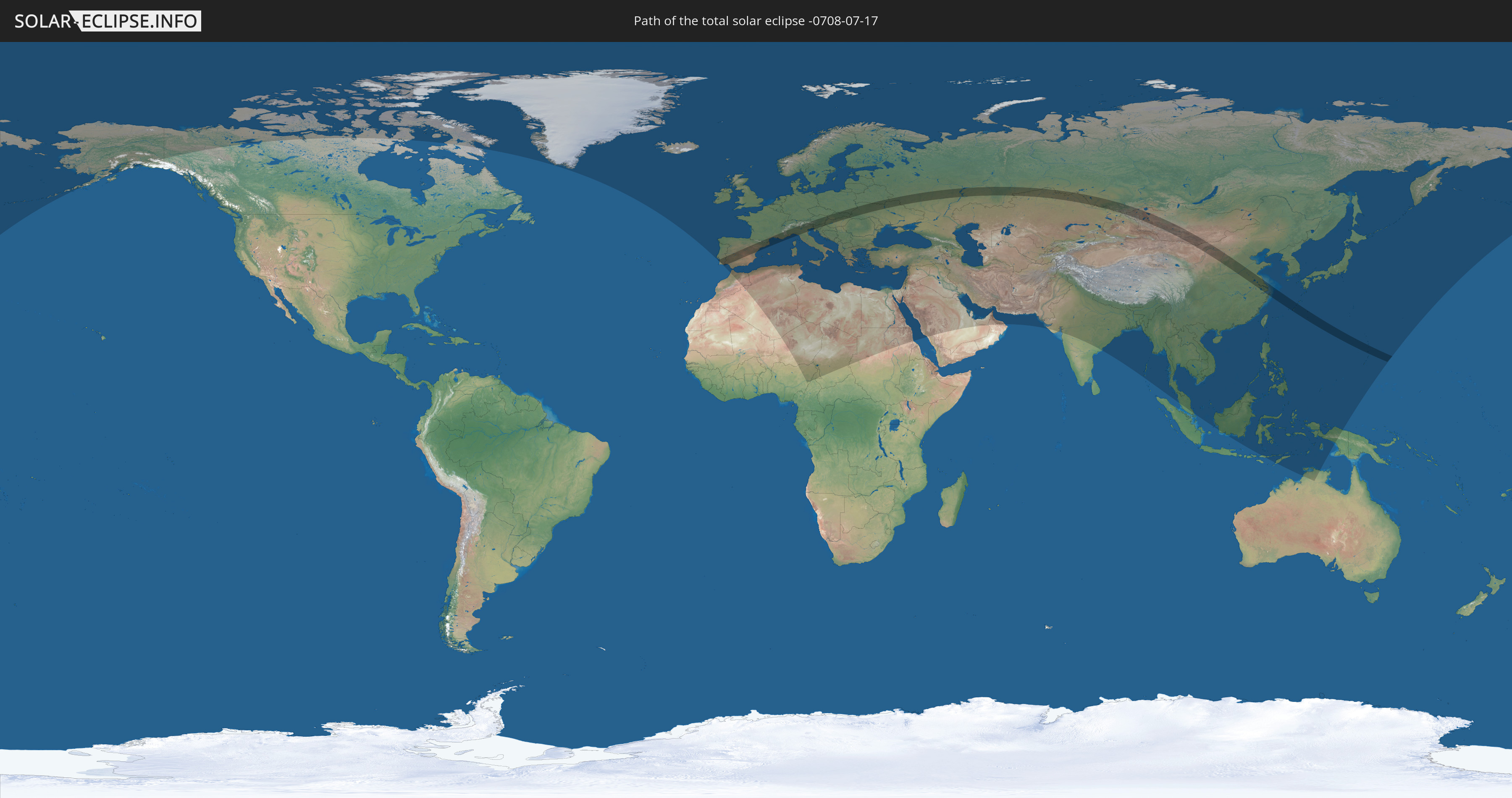
Die Sonnenfinsternis am 07/17/-0708 kann man in 116 Ländern als partielle Sonnenfinsternis beobachten.
Der Finsternispfad verläuft durch 20 Länder. Nur in diesen Ländern ist sie als total Sonnenfinsternis zu sehen.
In den folgenden Ländern ist die Sonnenfinsternis total zu sehen
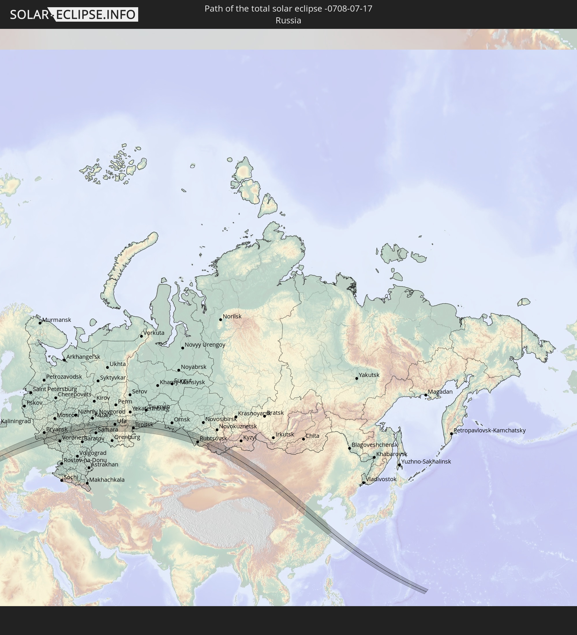 Russia
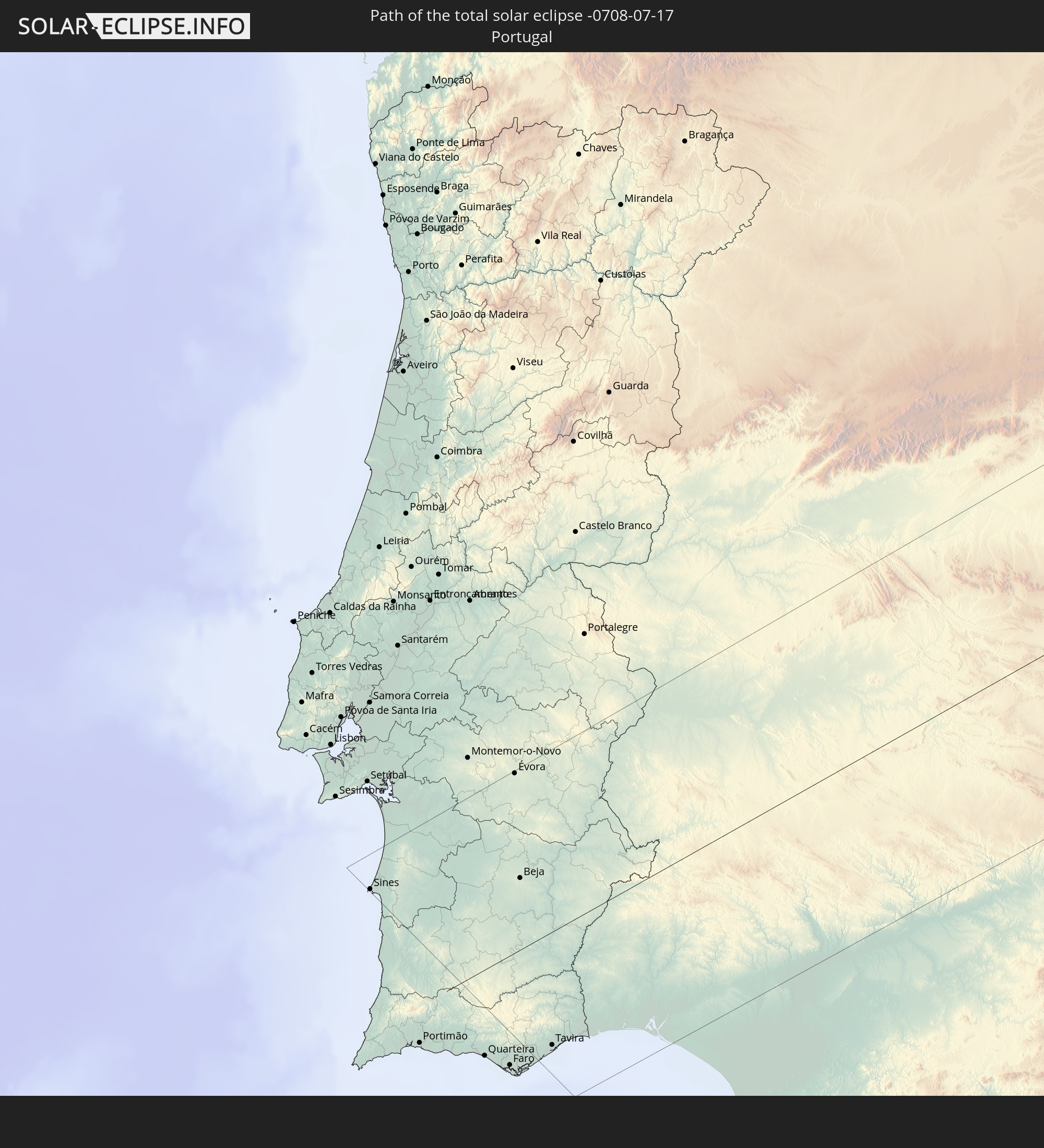 Portugal
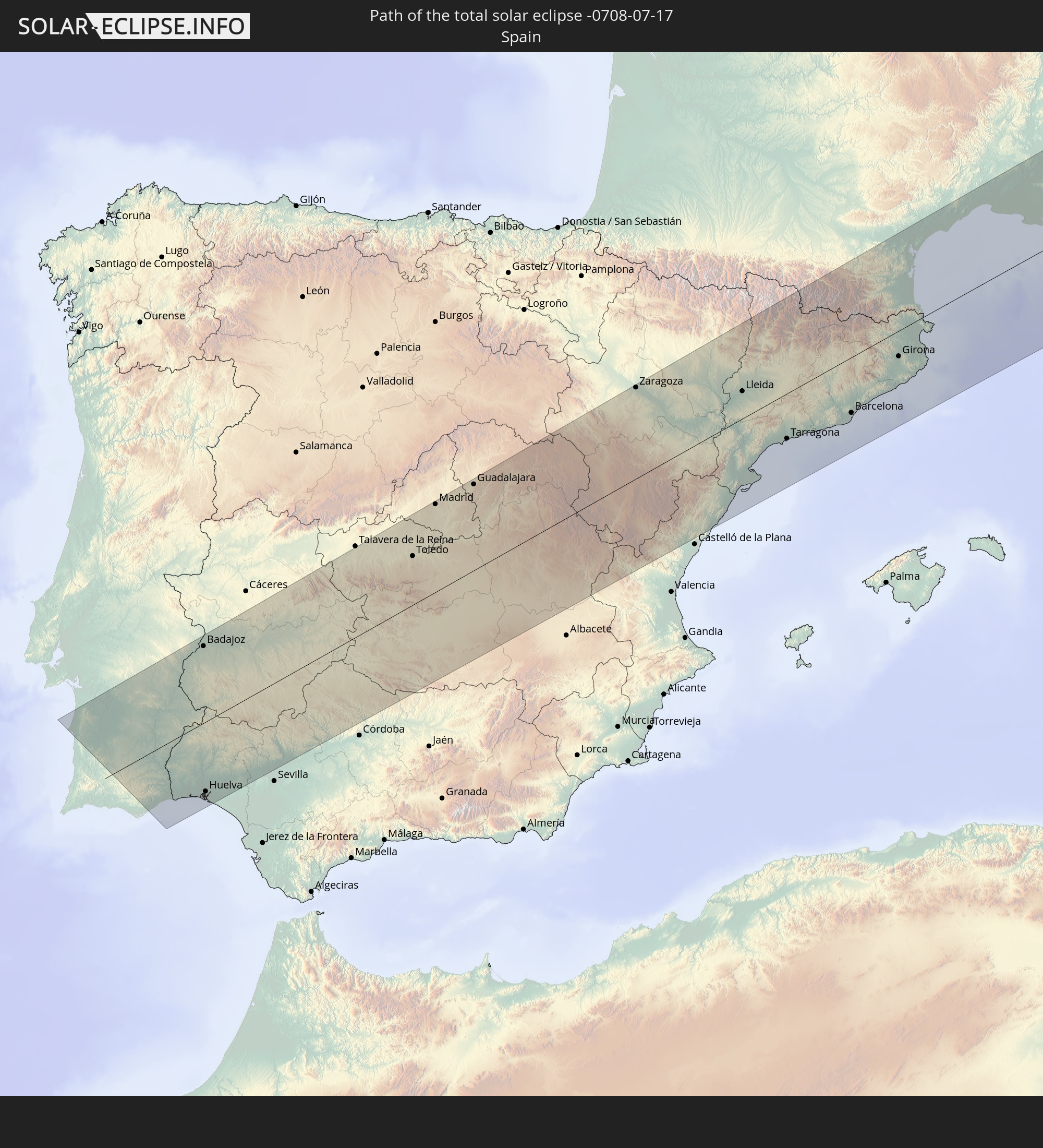 Spain
Spain
 France
 Andorra
 Italy
Italy
 Monaco
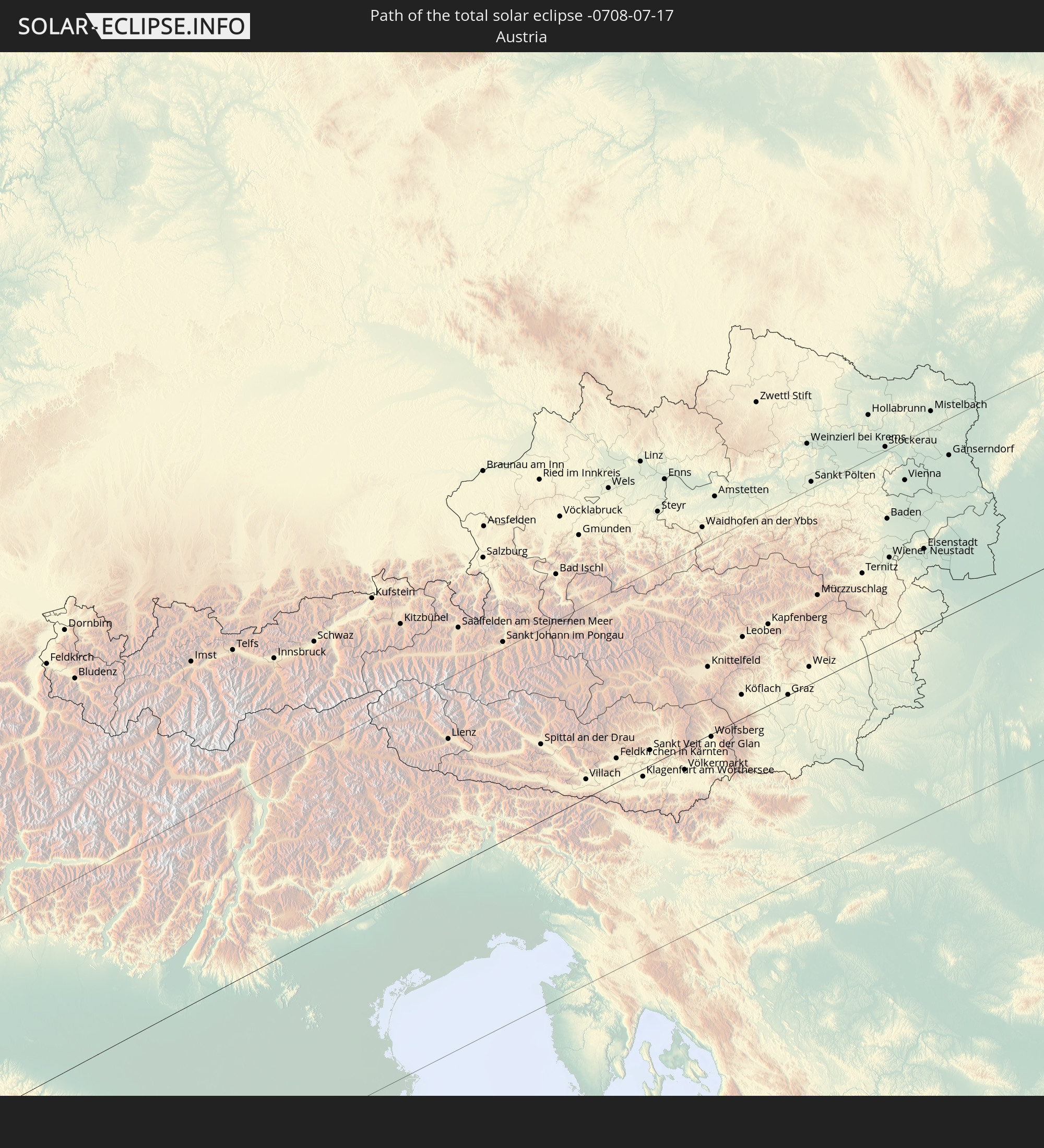 Austria
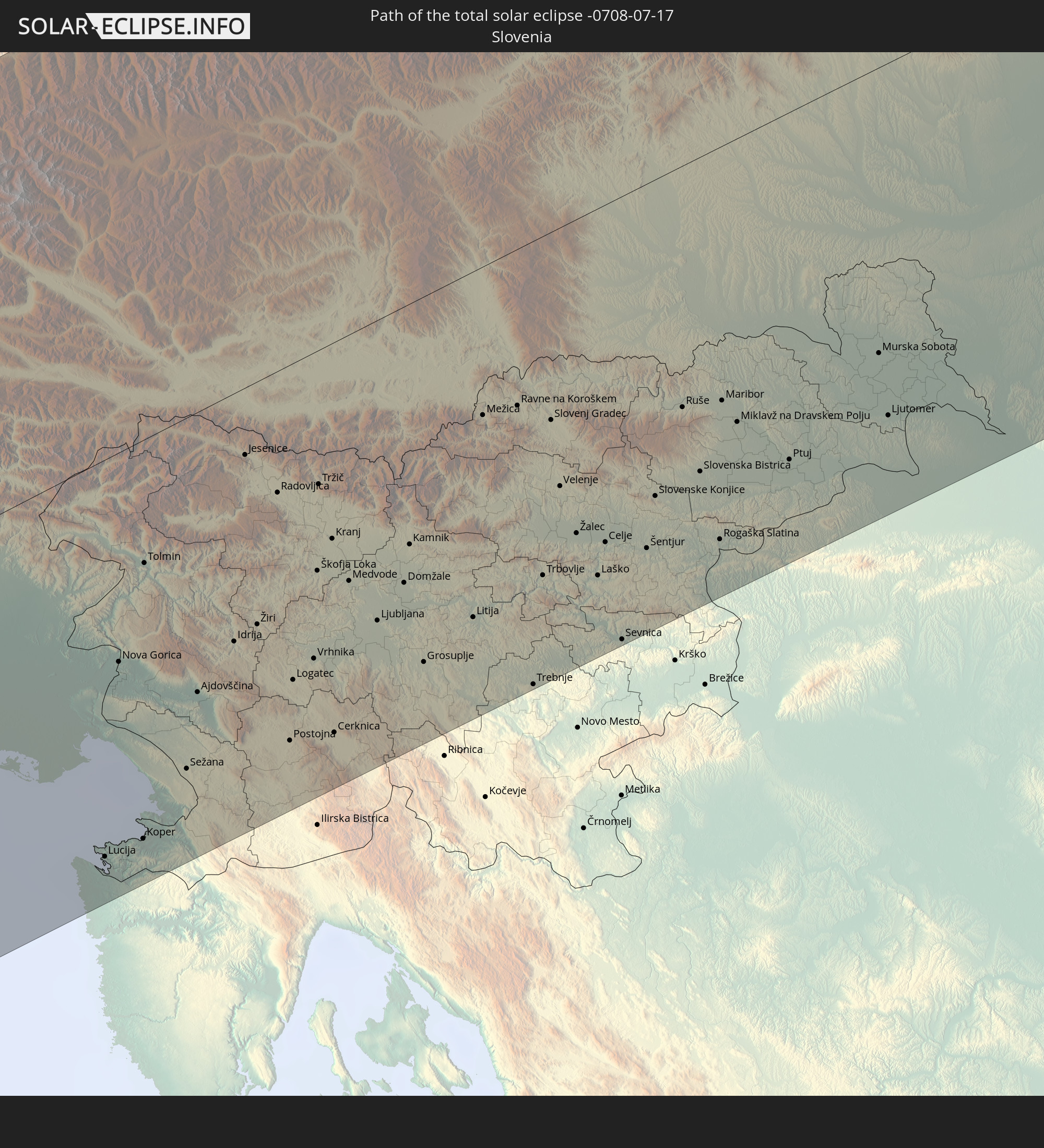 Slovenia
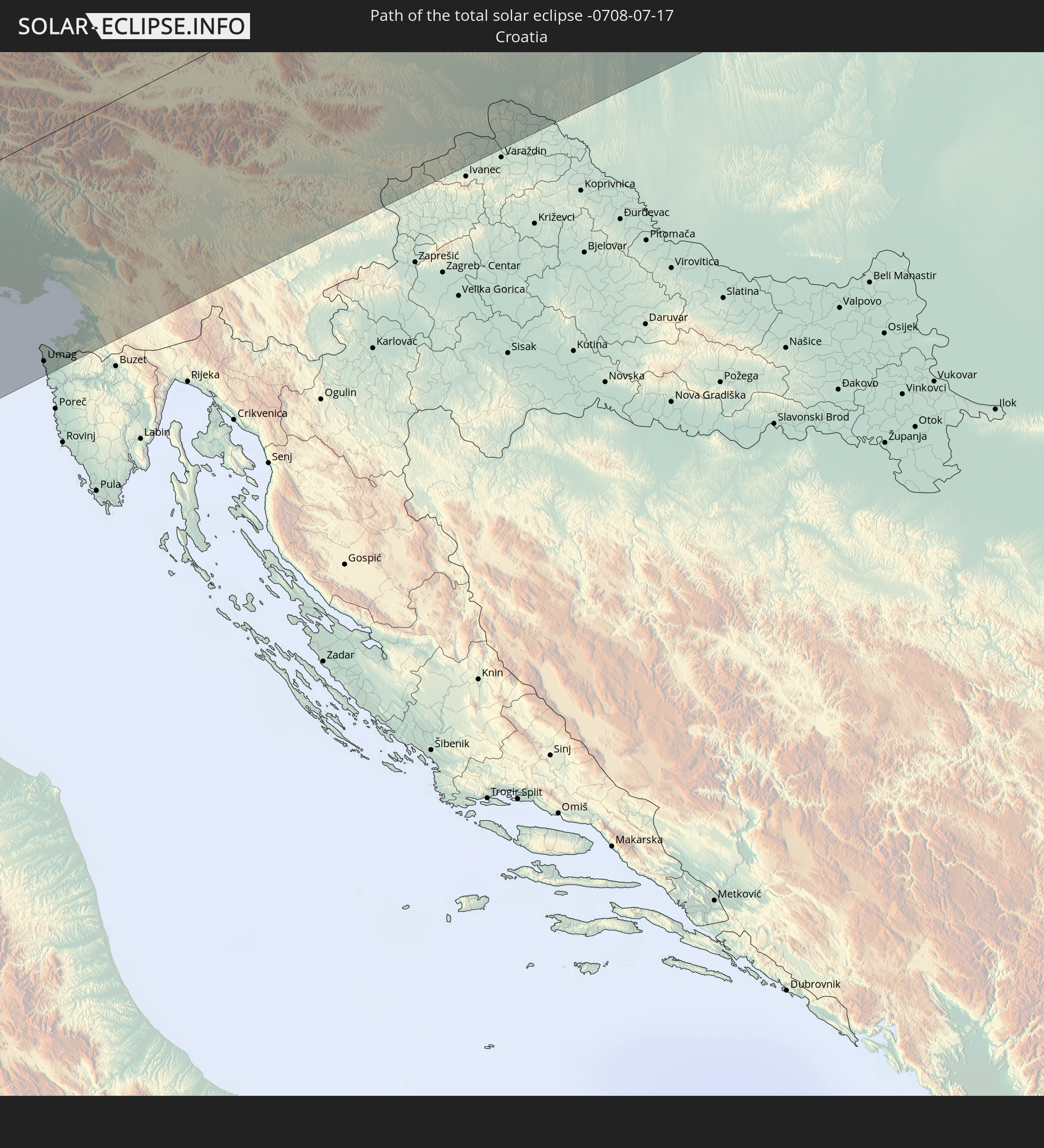 Croatia
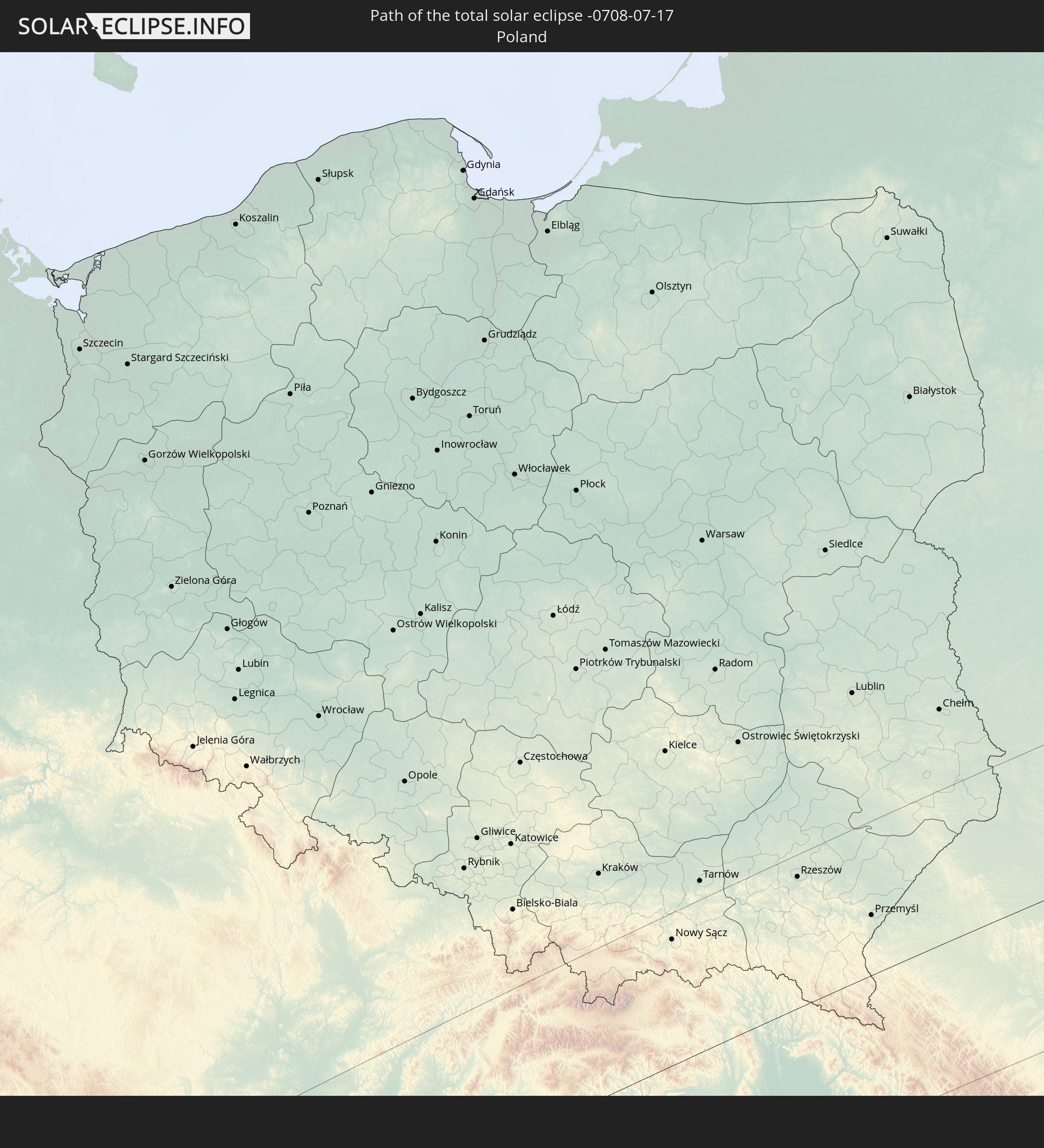 Poland
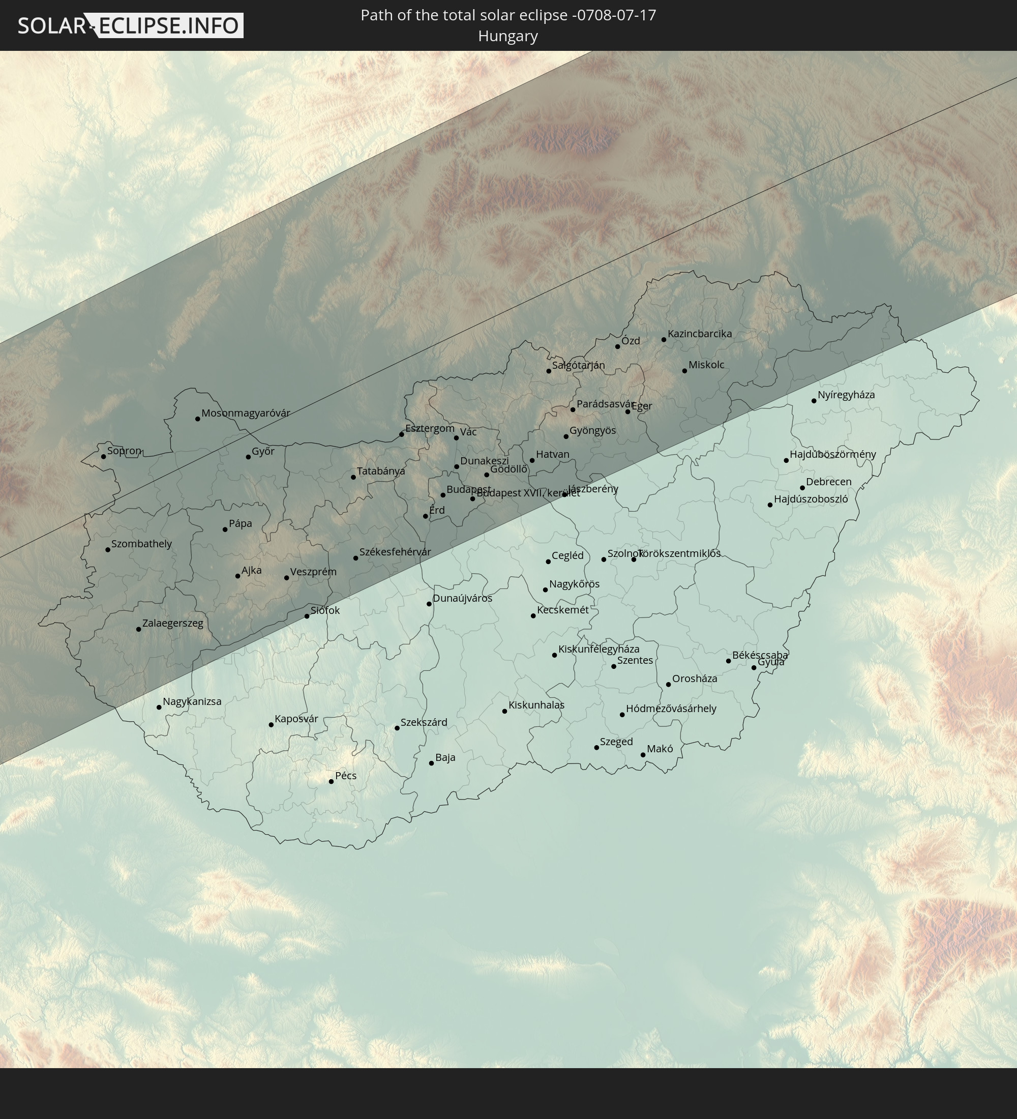 Hungary
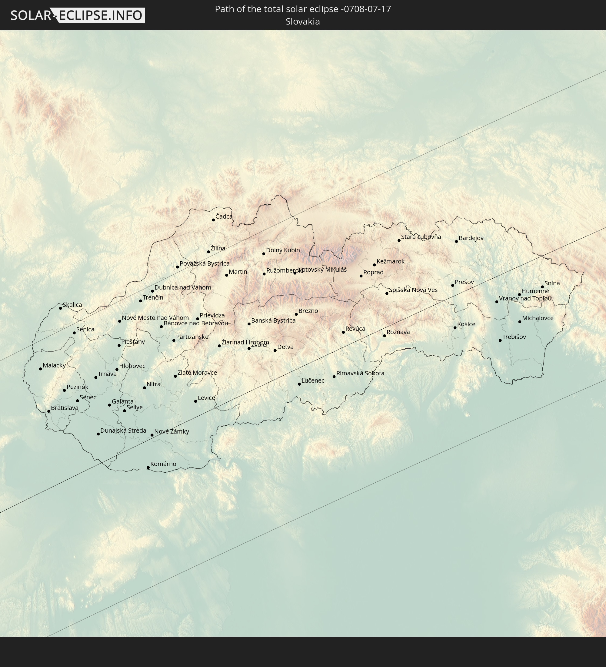 Slovakia
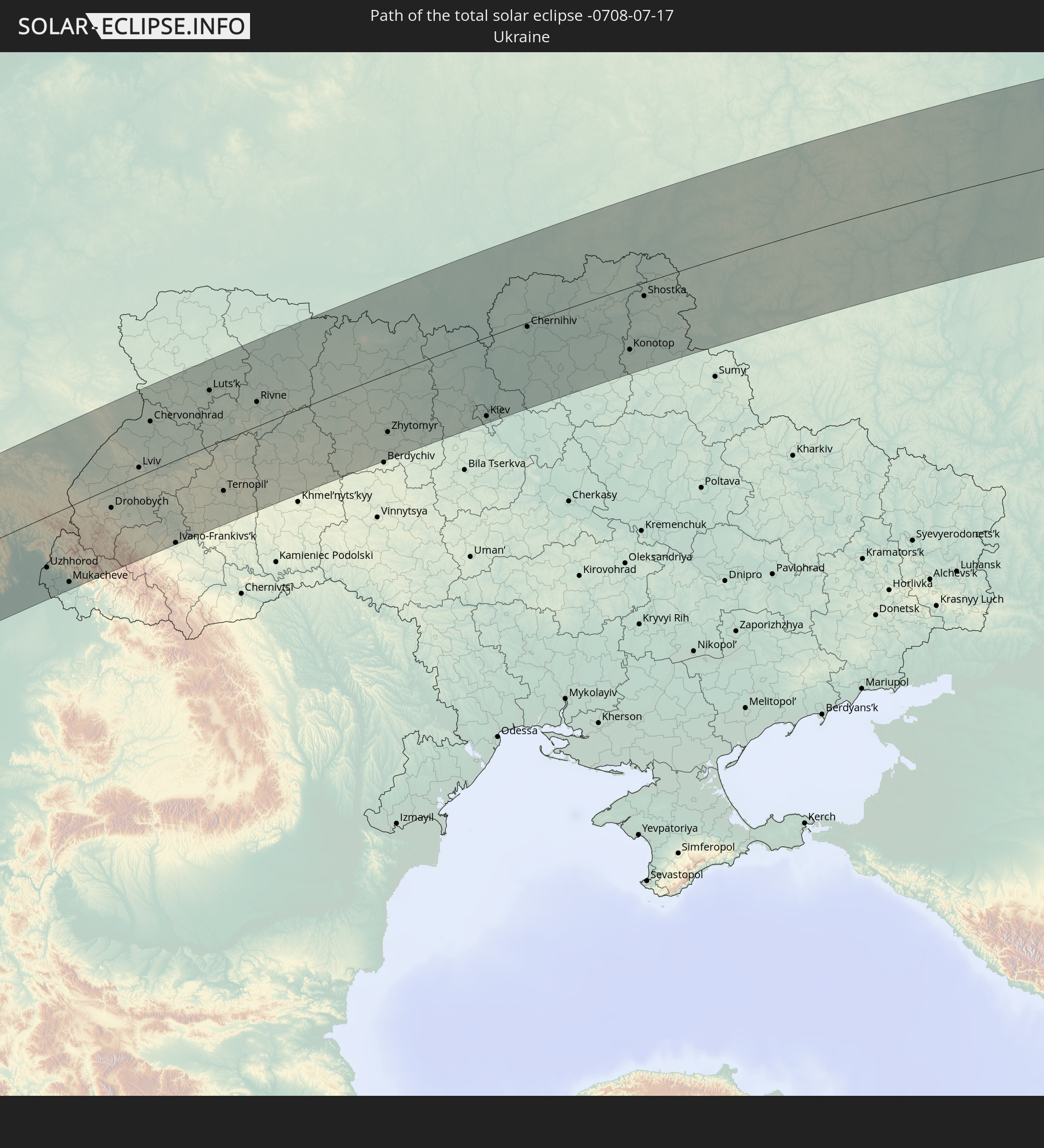 Ukraine
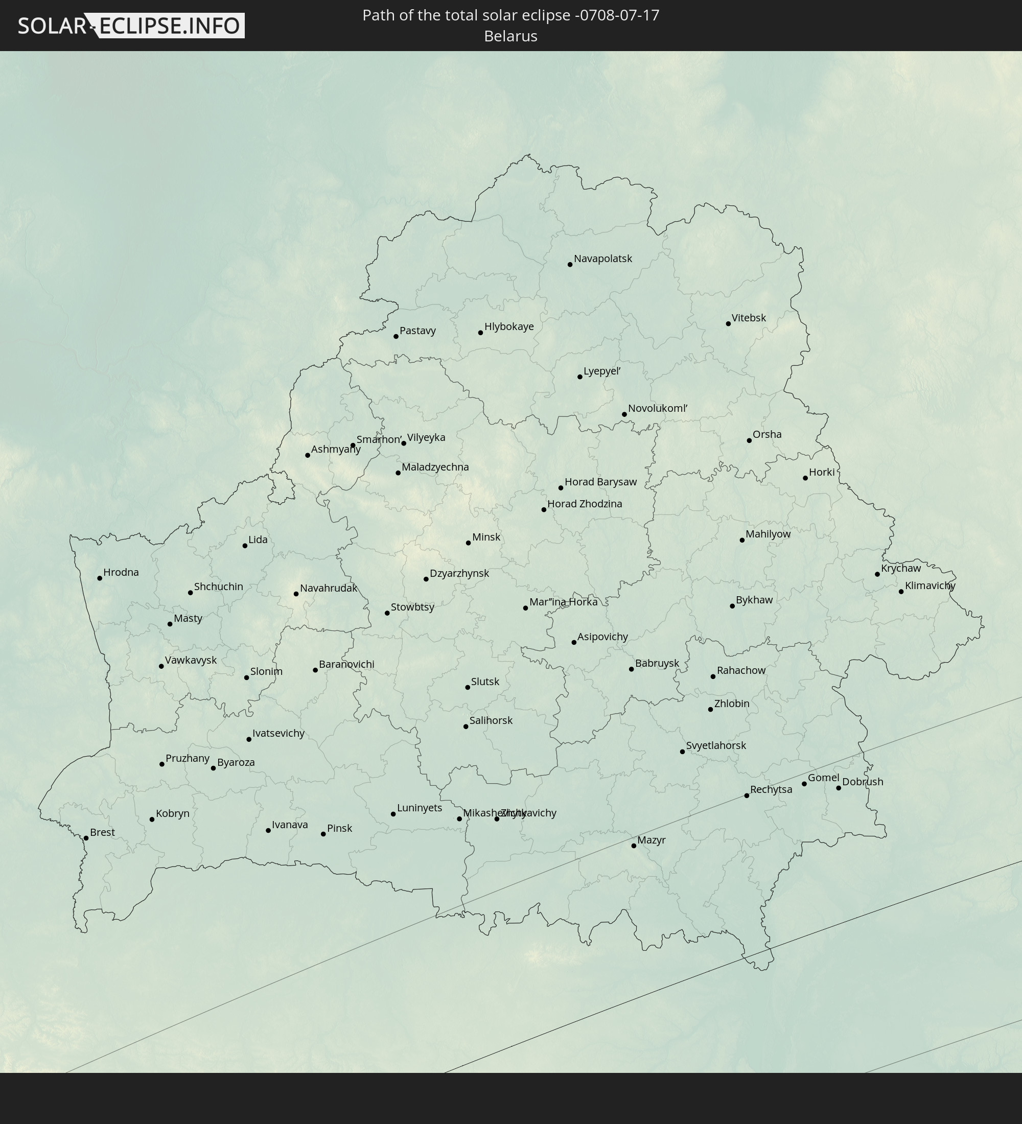 Belarus
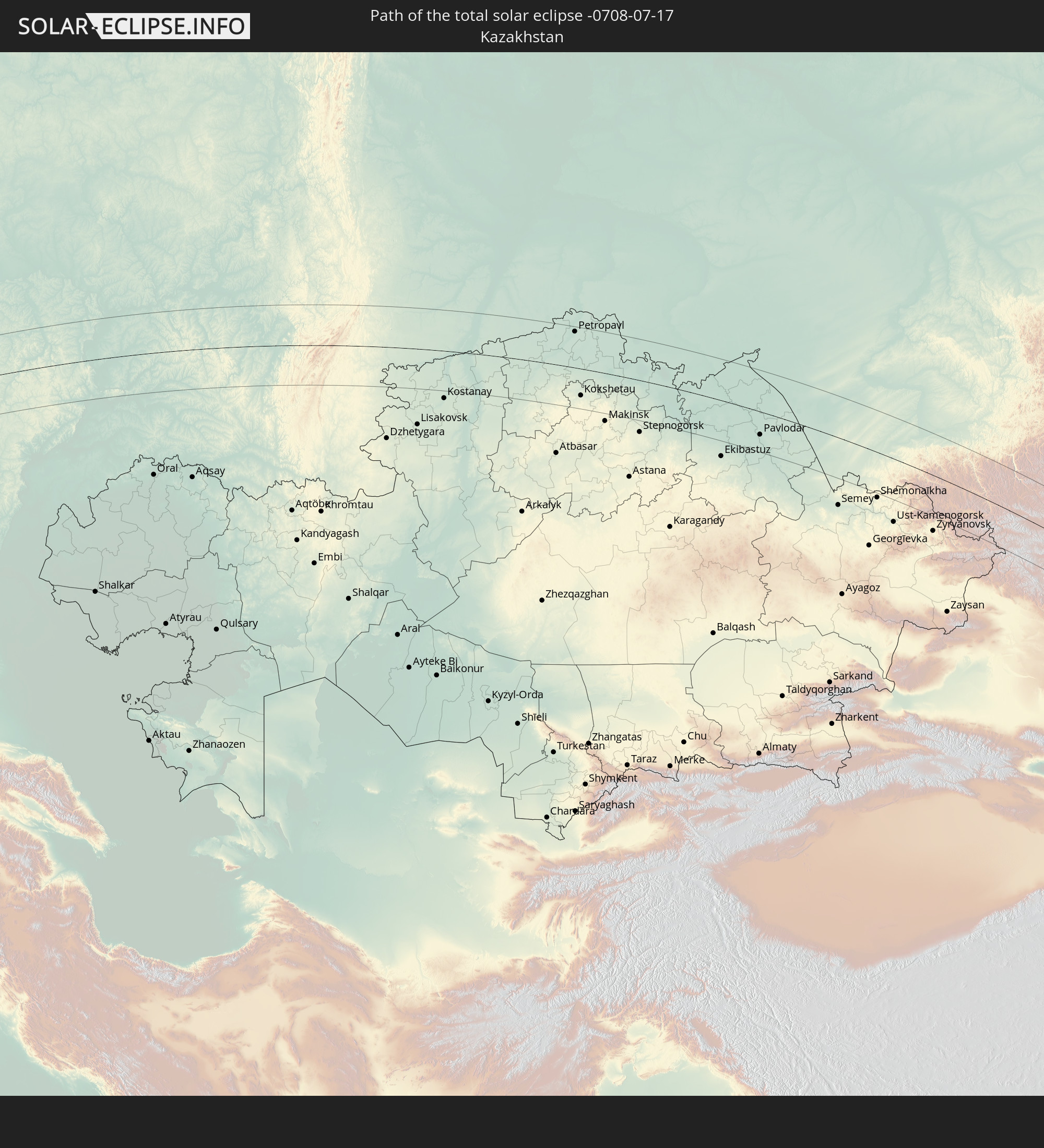 Kazakhstan
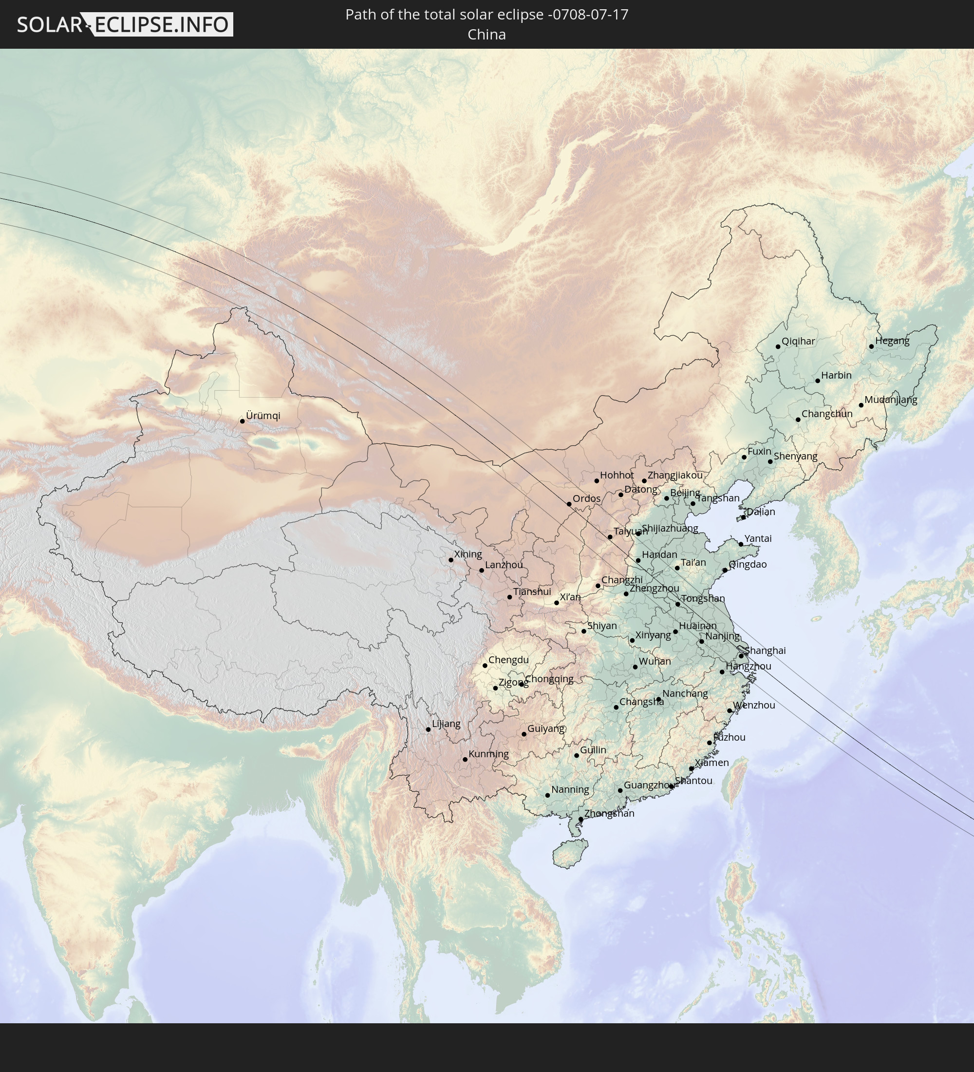 China
China
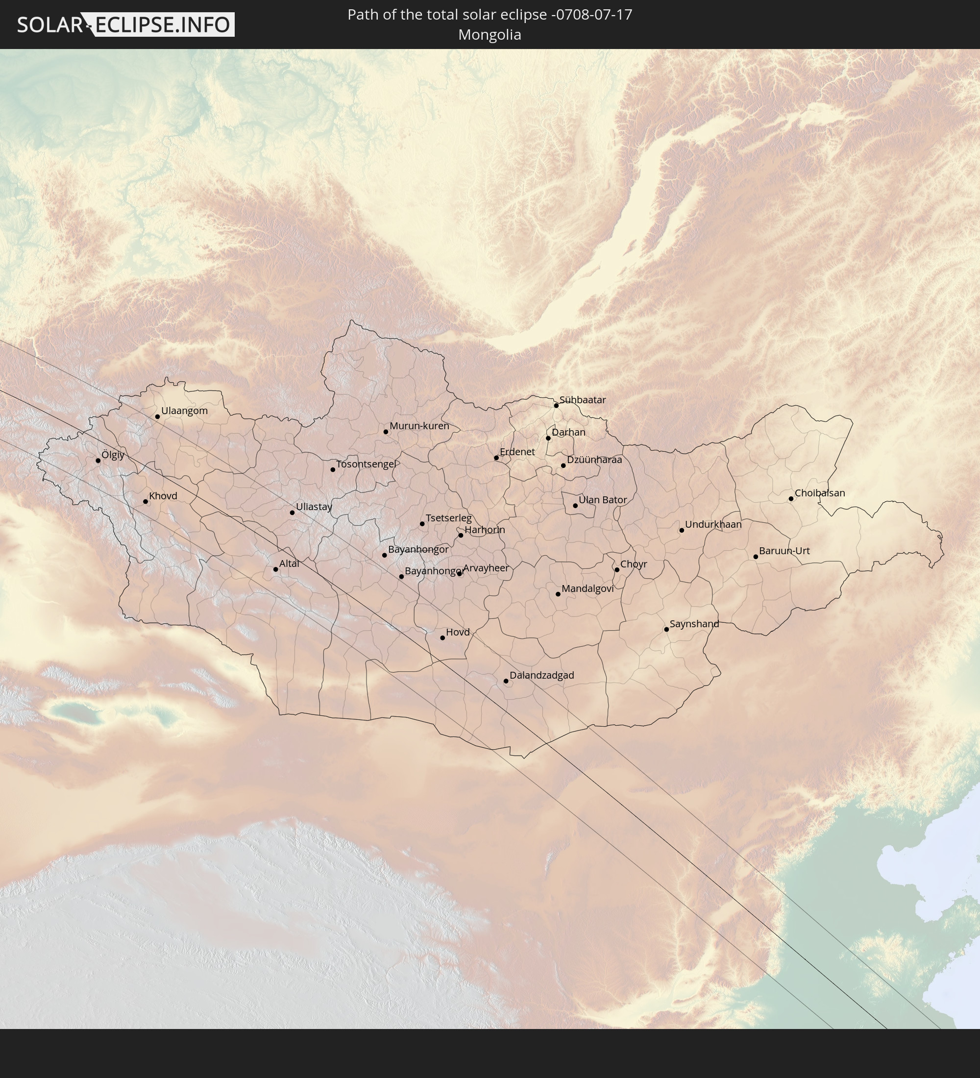 Mongolia
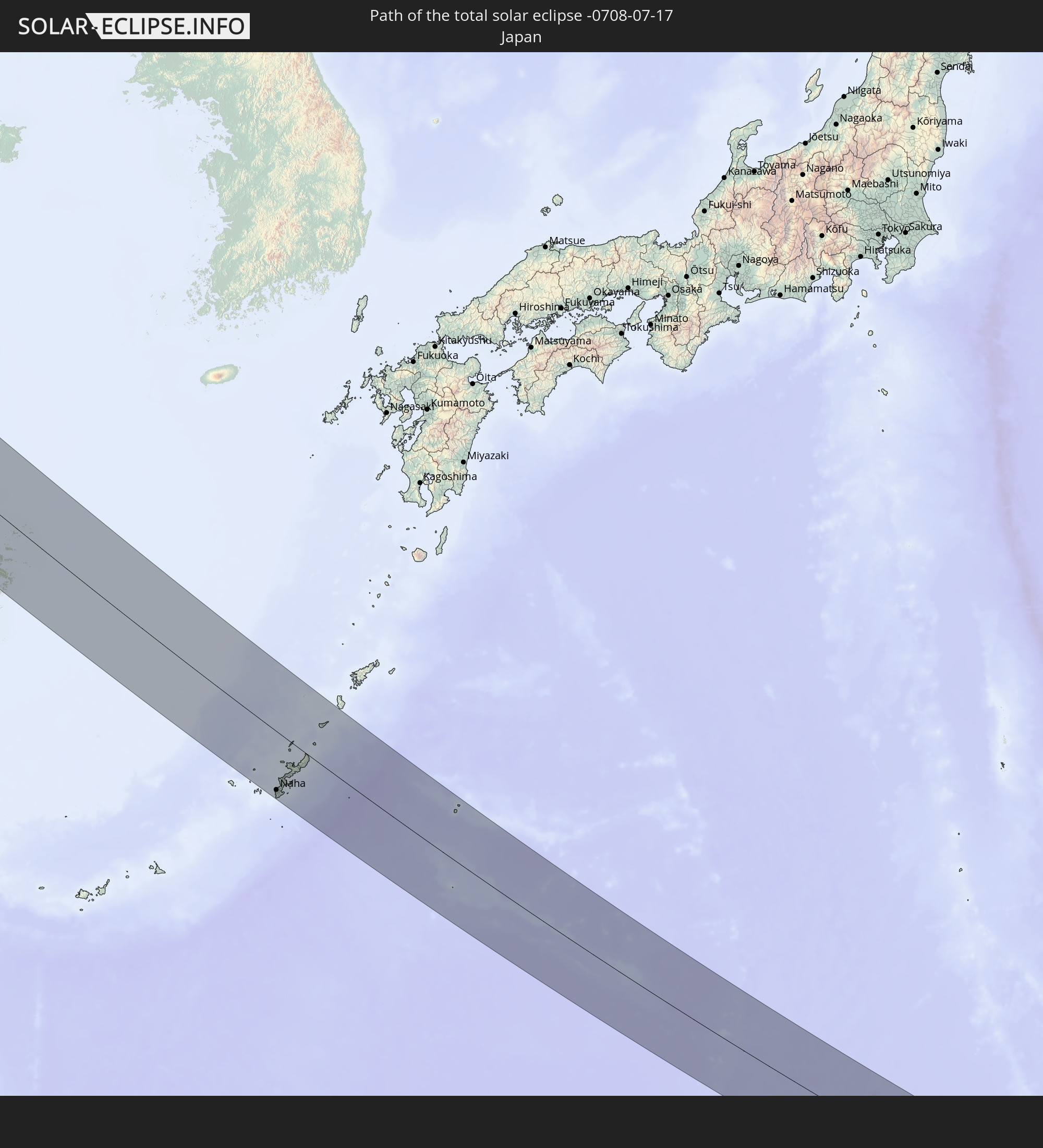 Japan
Japan
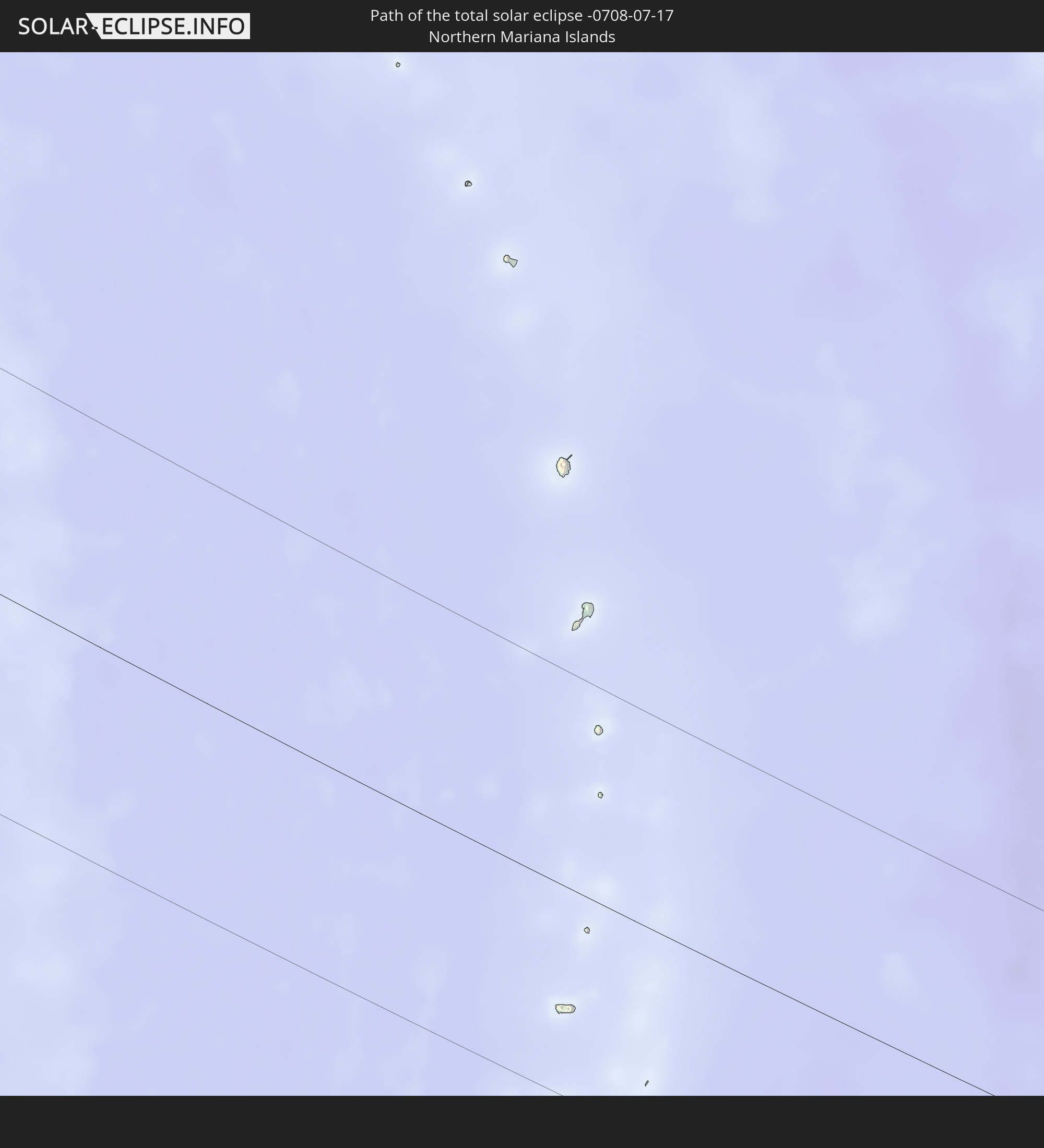 Northern Mariana Islands
In den folgenden Ländern ist die Sonnenfinsternis partiell zu sehen
 Russia
 United States
 Canada
 Greenland
 Portugal
 Iceland
 Spain
Spain
 Morocco
 Republic of Ireland
 Svalbard and Jan Mayen
 Algeria
 United Kingdom
 Faroe Islands
 Gibraltar
 France
 Isle of Man
 Guernsey
 Jersey
 Niger
Niger
 Andorra
 Belgium
 Nigeria
 Netherlands
 Norway
 Luxembourg
 Germany
 Switzerland
 Italy
Italy
 Monaco
 Tunisia
 Denmark
 Cameroon
 Libya
Libya
 Liechtenstein
 Austria
 Sweden
 Czechia
 San Marino
 Vatican City
 Slovenia
 Chad
Chad
 Croatia
 Poland
 Malta
Malta
 Bosnia and Herzegovina
 Hungary
 Slovakia
 Montenegro
 Serbia
 Albania
 Åland Islands
 Greece
 Romania
 Republic of Macedonia
 Finland
 Lithuania
 Latvia
 Estonia
 Sudan
Sudan
 Ukraine
 Bulgaria
 Belarus
 Egypt
Egypt
 Turkey
 Moldova
 Cyprus
 State of Palestine
 Israel
 Saudi Arabia
 Jordan
 Lebanon
 Syria
Syria
 Iraq
Iraq
 Georgia
 Armenia
 Iran
Iran
 Azerbaijan
 Kazakhstan
 Kuwait
 Bahrain
 Qatar
Qatar
 United Arab Emirates
 Oman
Oman
 Turkmenistan
 Uzbekistan
 Afghanistan
 Pakistan
 Tajikistan
 India
India
 Kyrgyzstan
 China
China
 Nepal
Nepal
 Mongolia
 Bangladesh
 Bhutan
 Myanmar
 Indonesia
 Thailand
 Malaysia
 Laos
Laos
 Vietnam
 Cambodia
 Australia
 Macau
Macau
 Hong Kong
 Brunei
 Taiwan
 Philippines
 Japan
Japan
 East Timor
 North Korea
 South Korea
 Palau
Palau
 Federated States of Micronesia
 Guam
Guam
 Northern Mariana Islands
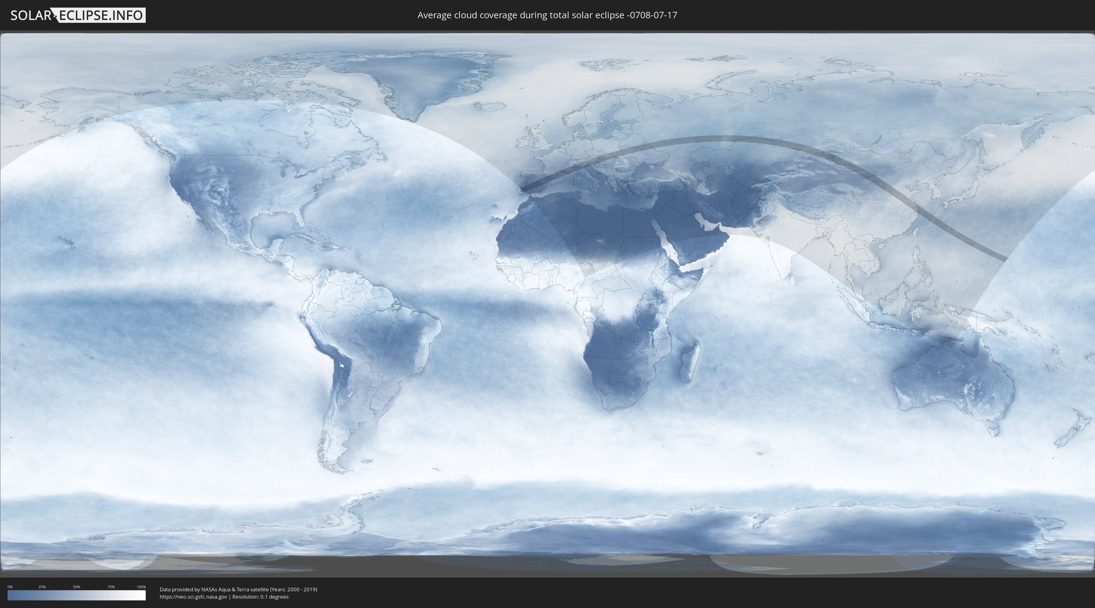
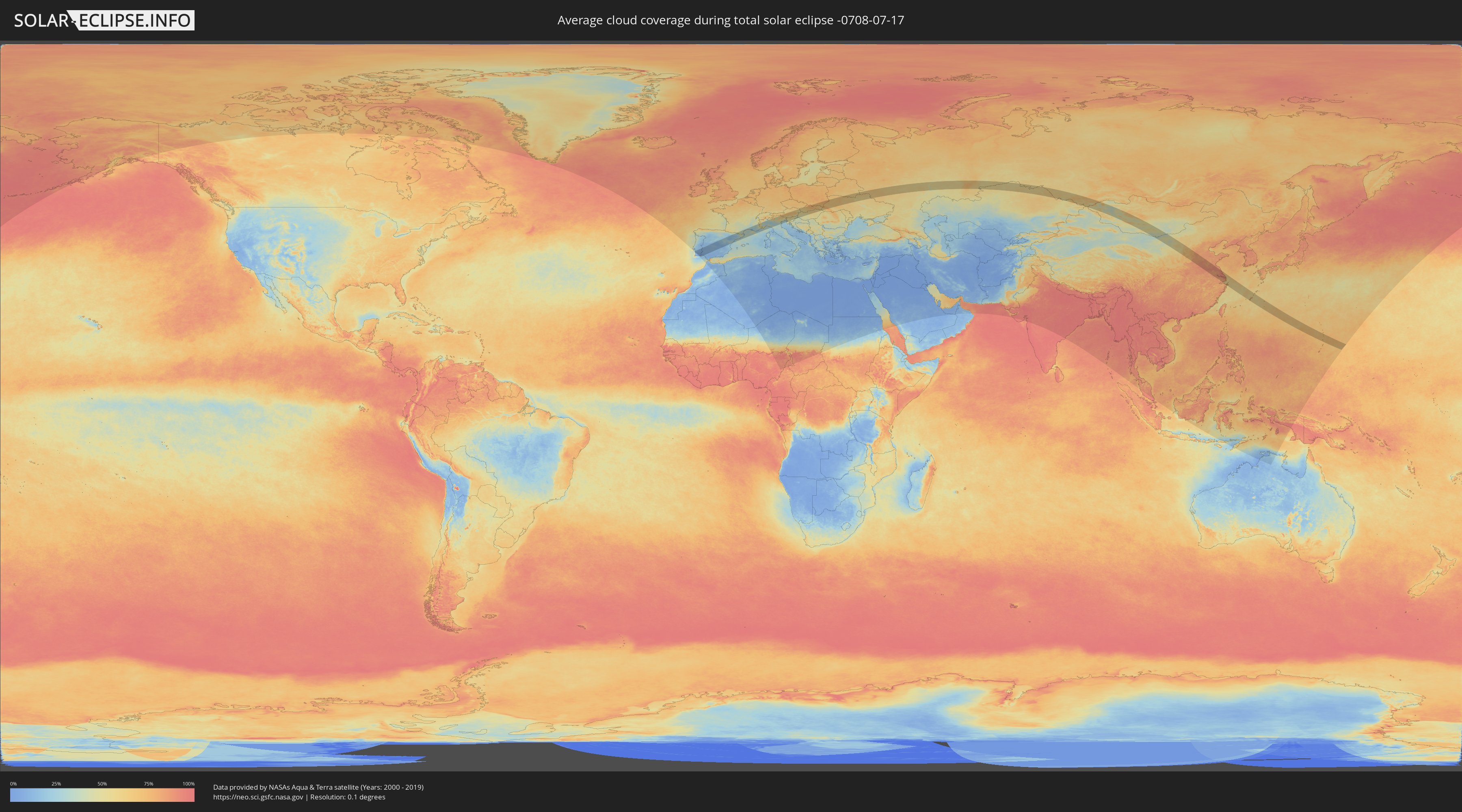
How will be the weather during the total solar eclipse on 07/17/-0708?
Where is the best place to see the total solar eclipse of 07/17/-0708?
The following maps show the average cloud coverage for the day of the total solar eclipse.
With the help of these maps, it is possible to find the place along the eclipse path, which has the best
chance of a cloudless sky.
Nevertheless, you should consider local circumstances and inform about the weather of your chosen
observation site.
The data is provided by NASAs satellites
AQUA and TERRA.
The cloud maps are averaged over a period of 19 years (2000 - 2019).
Detailed country maps
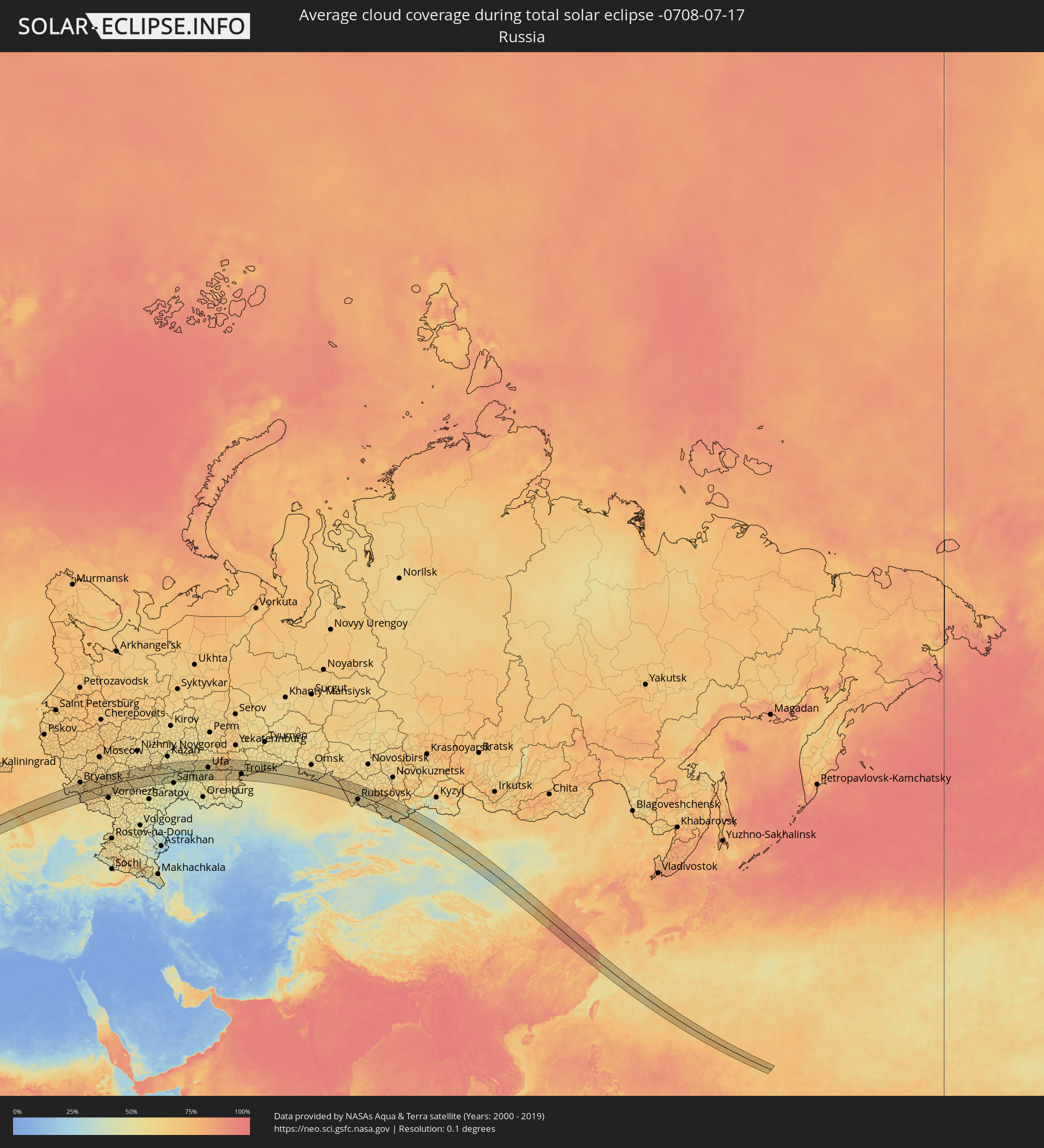 Russia
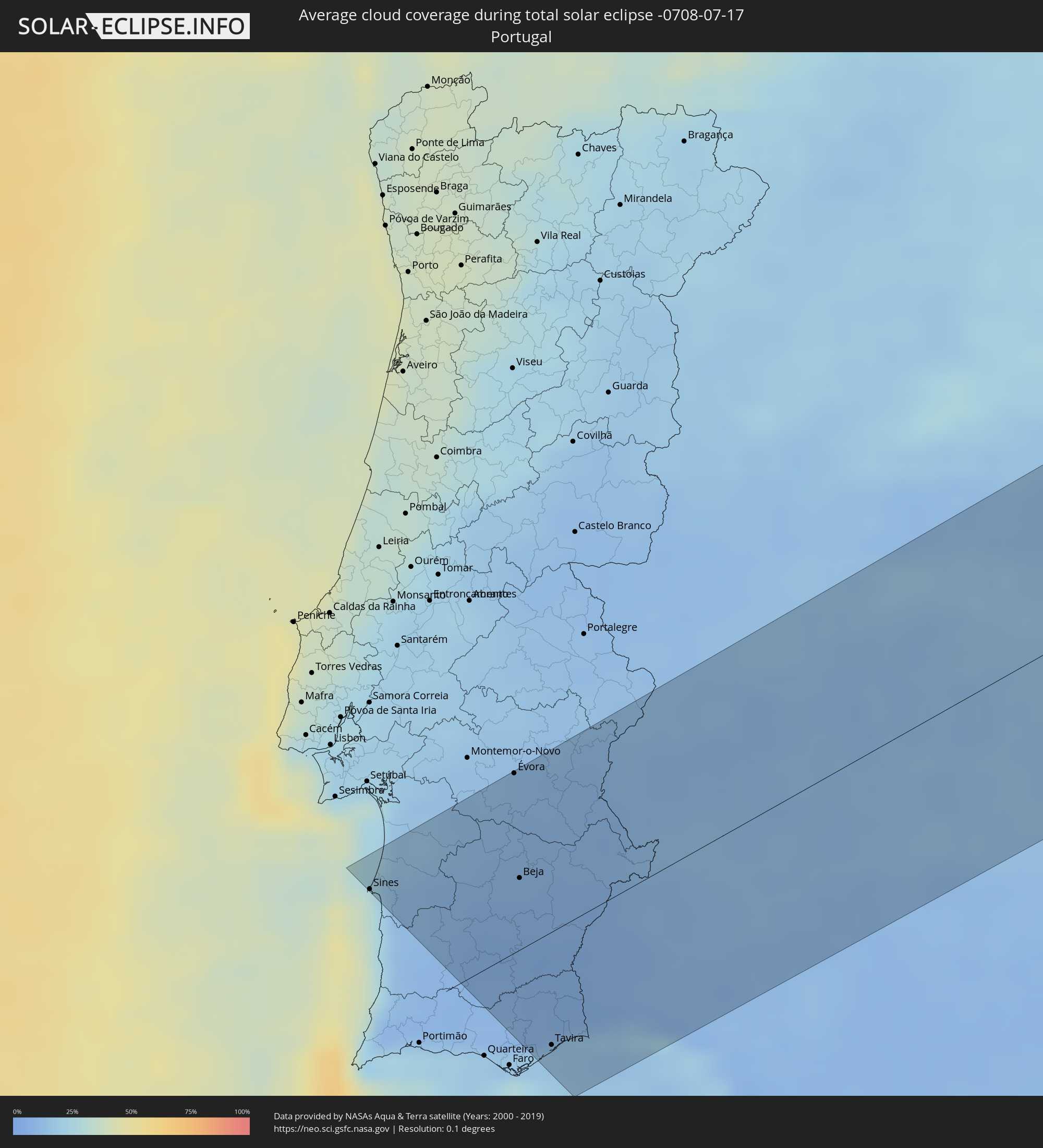 Portugal
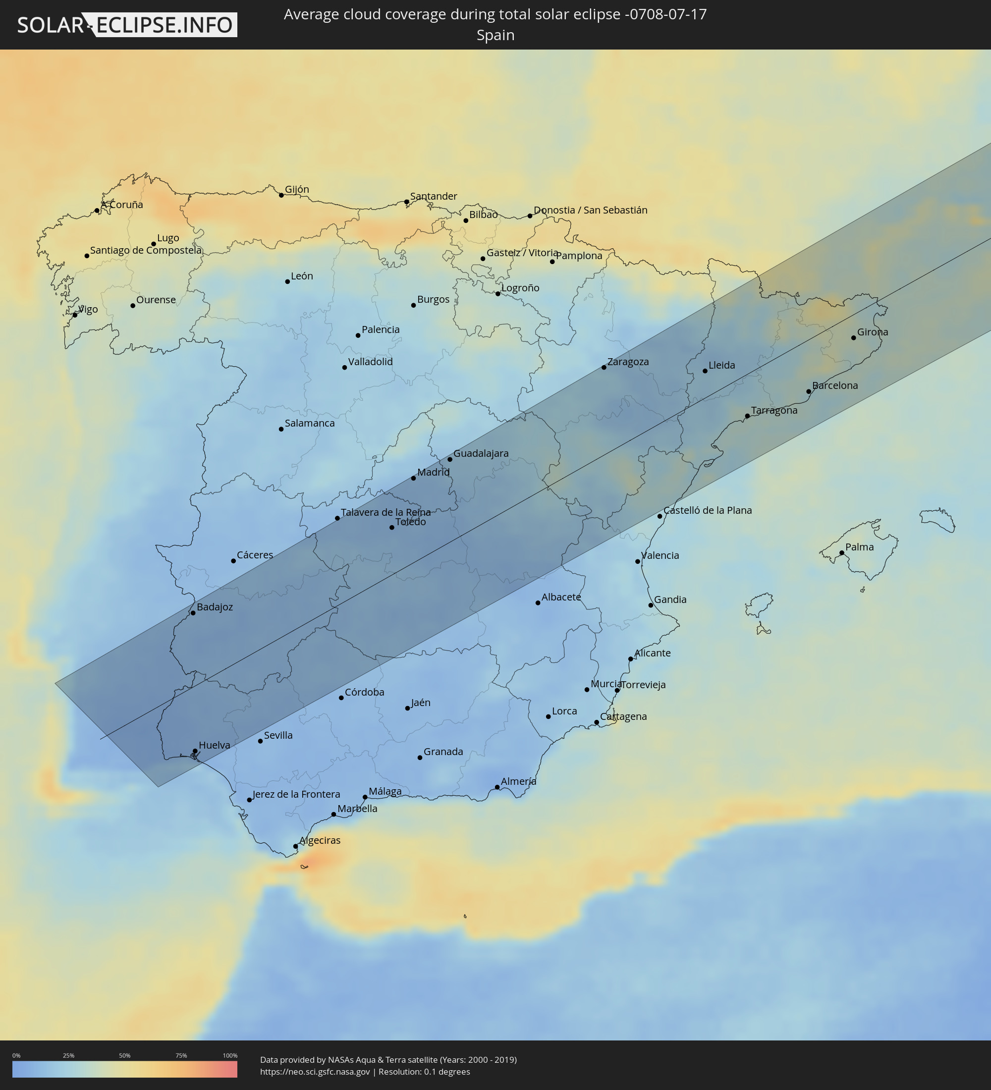 Spain
Spain
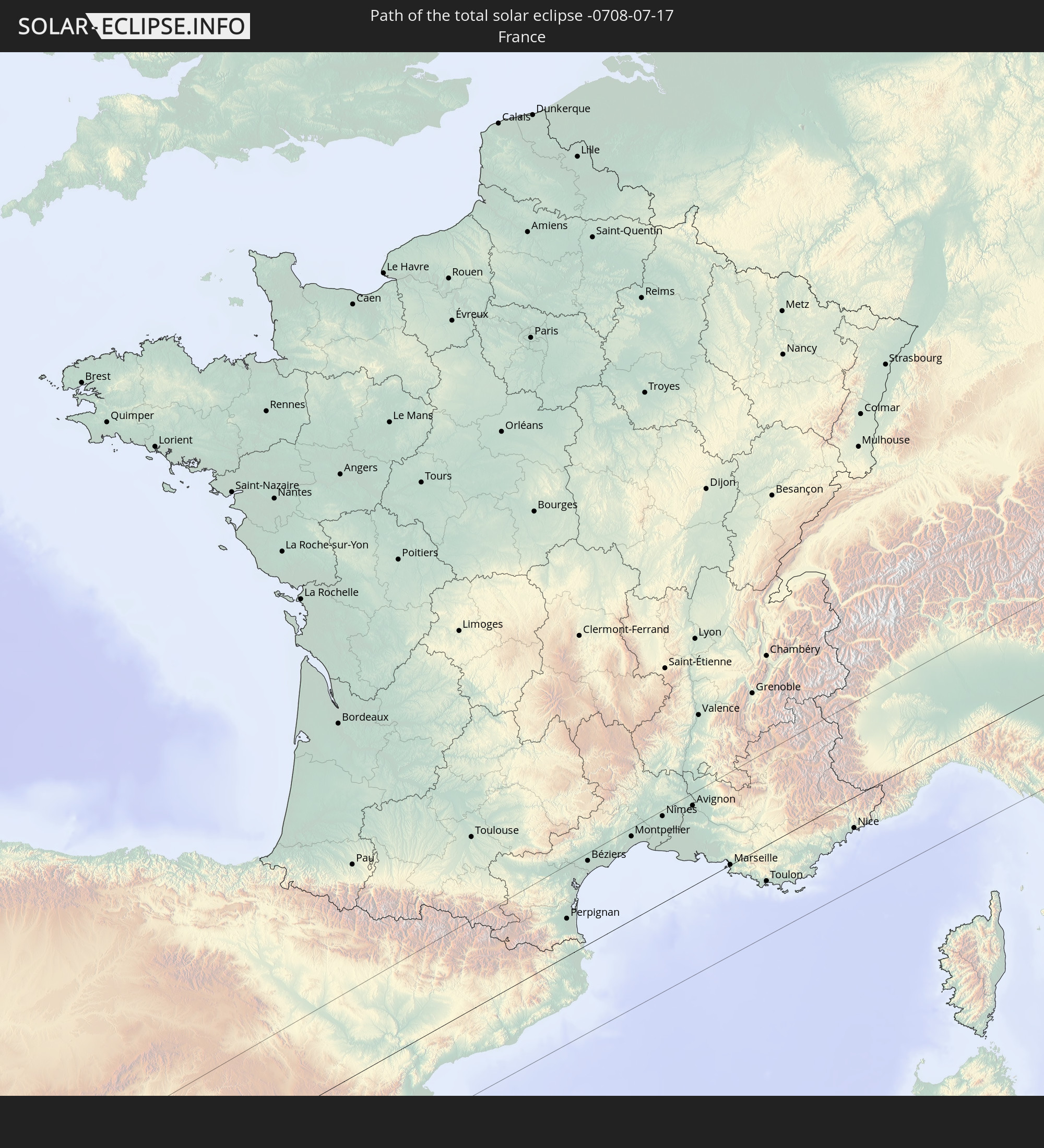
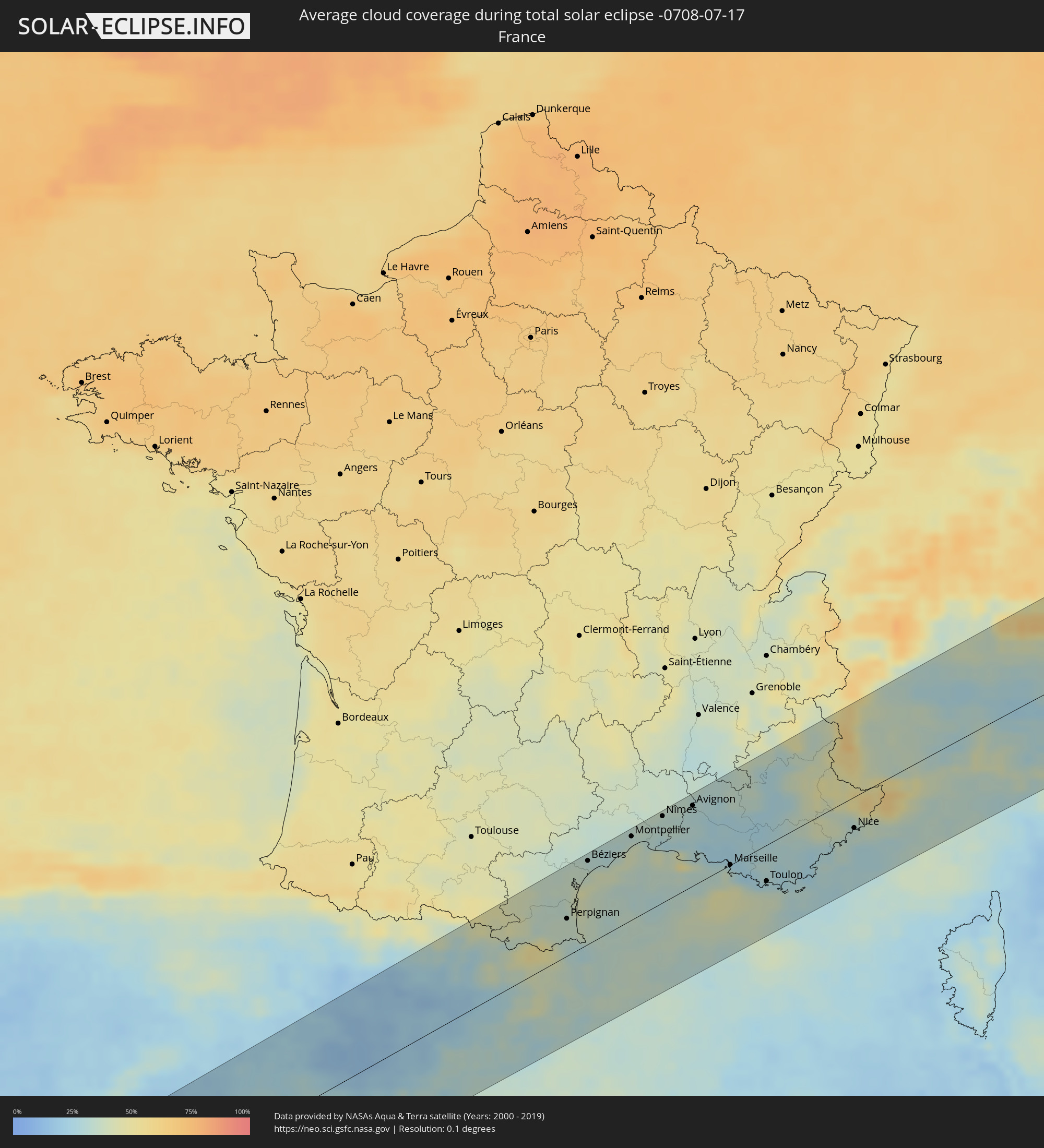 France
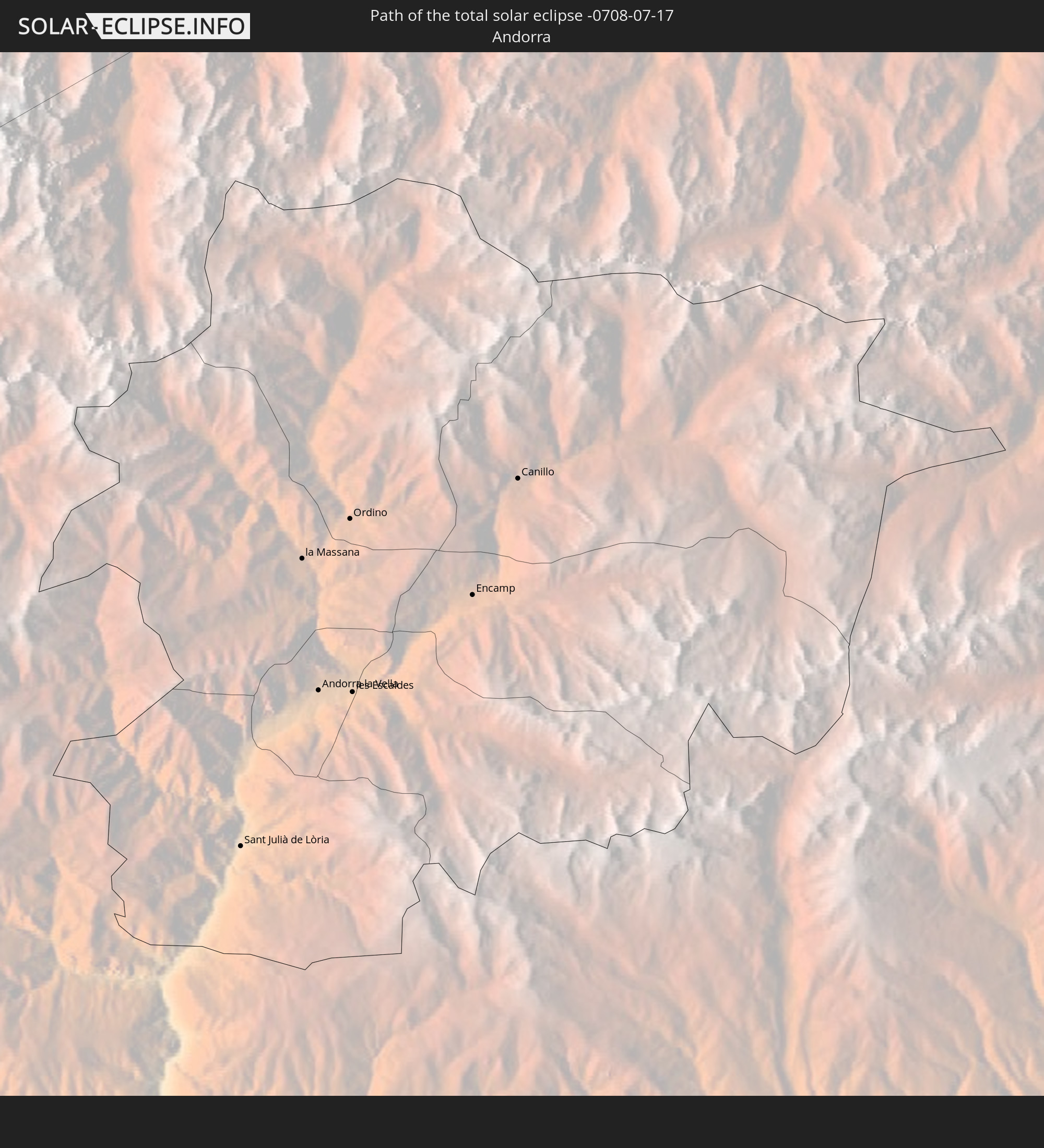
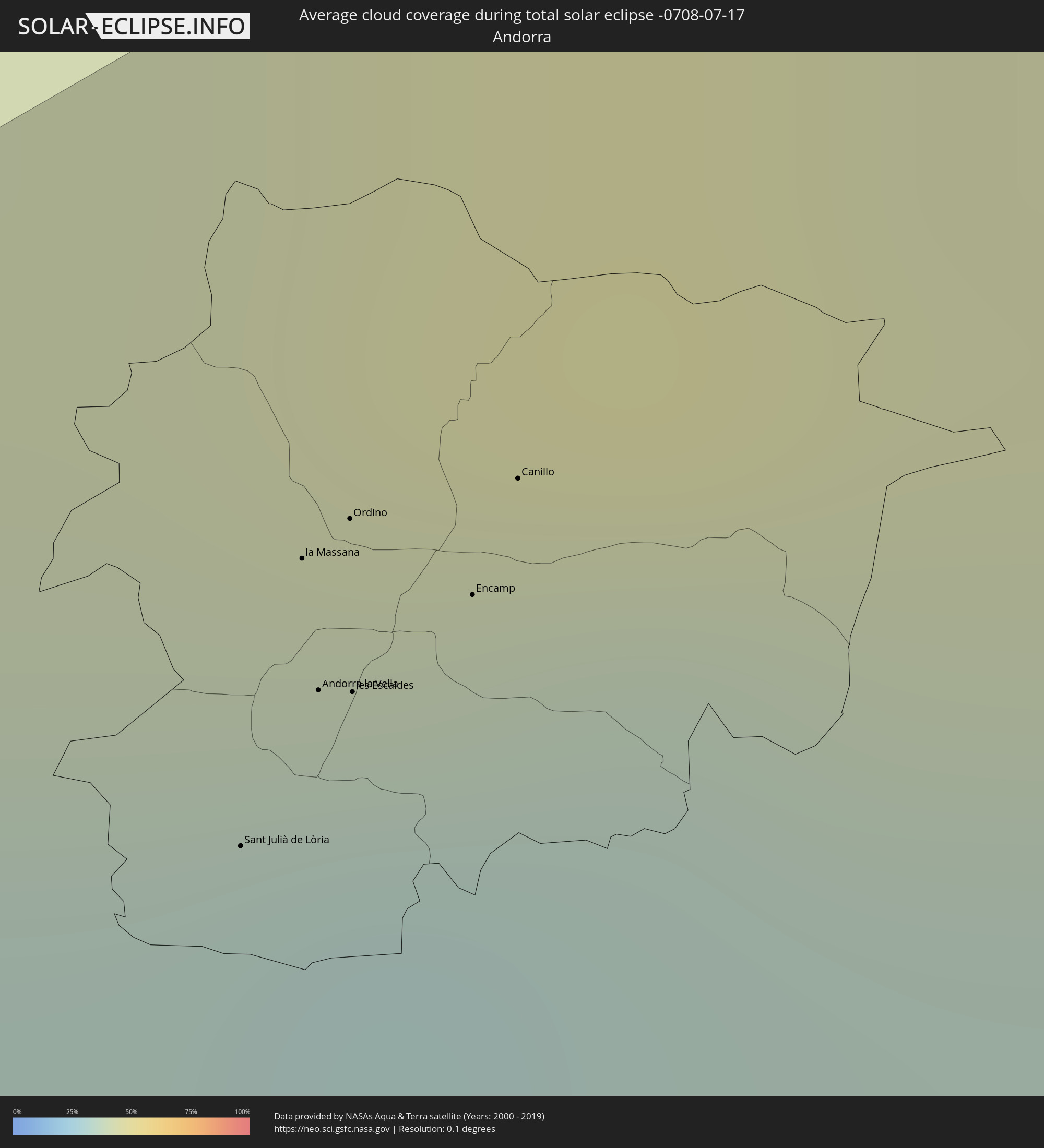 Andorra
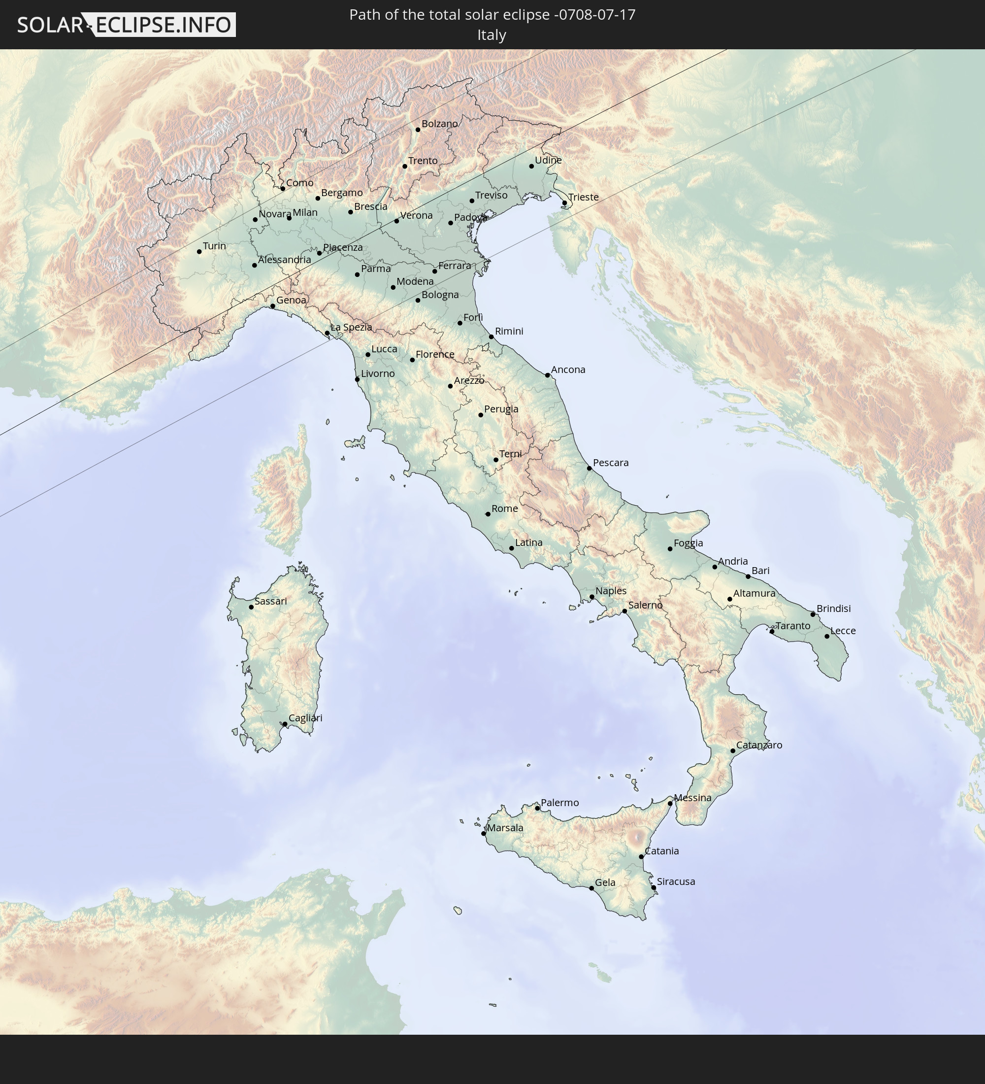
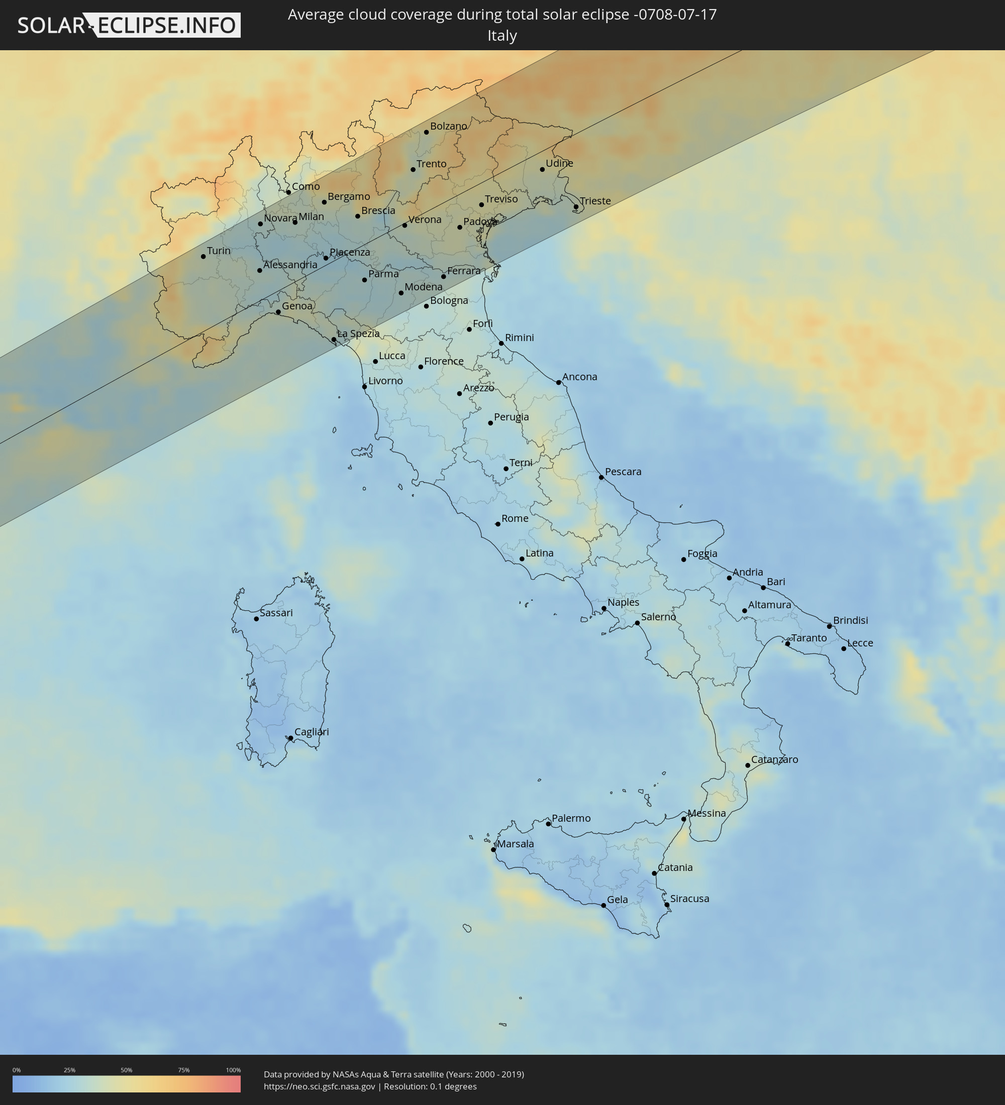 Italy
Italy
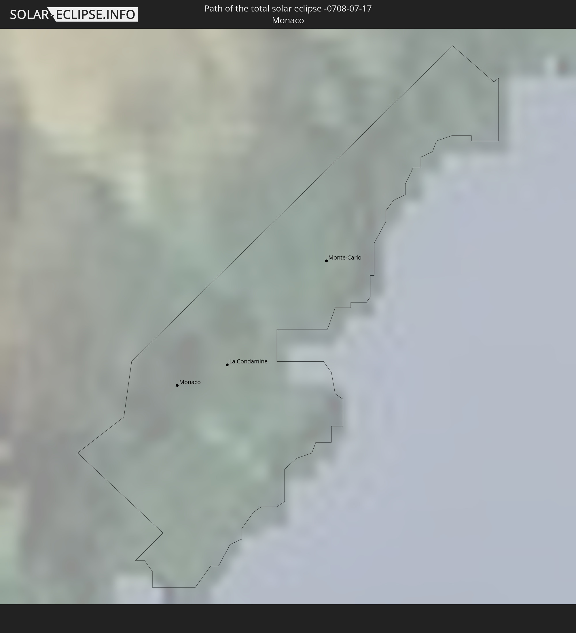
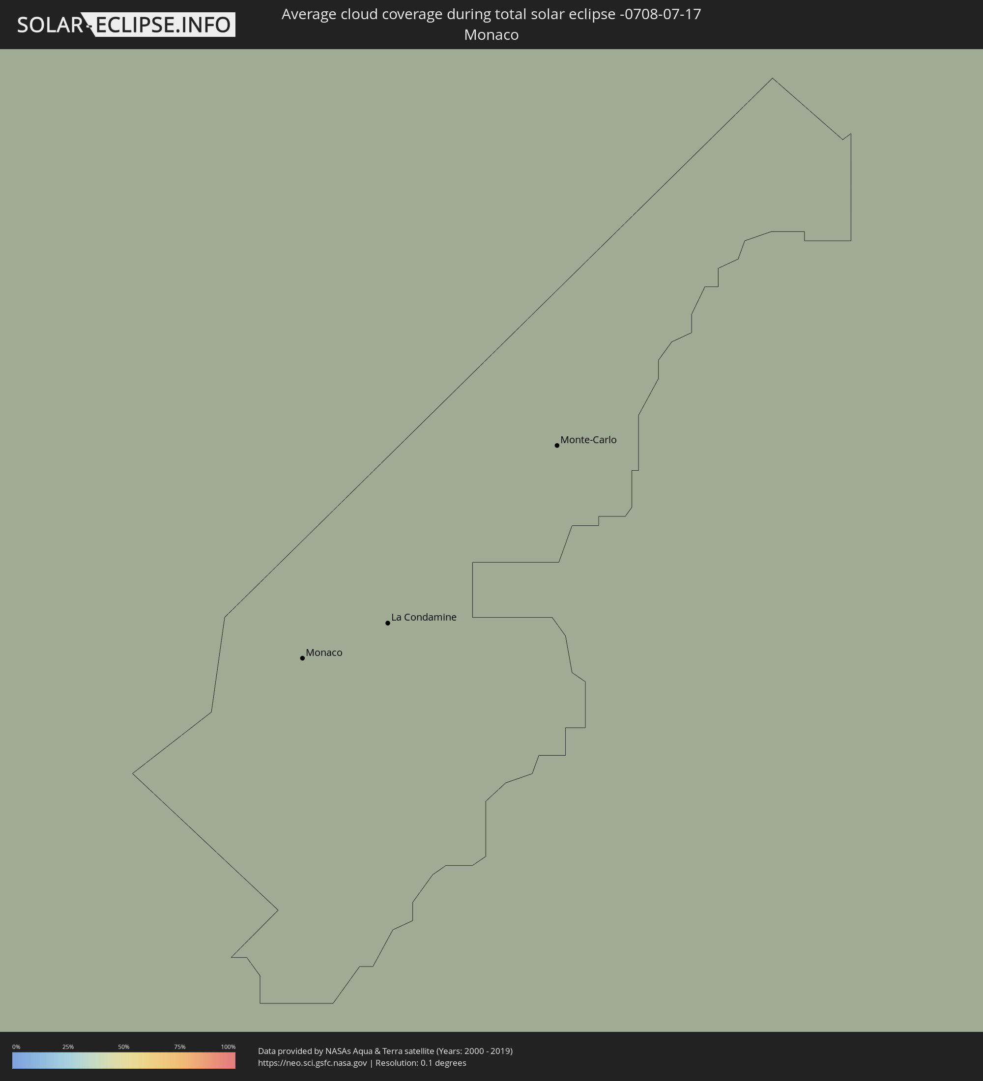 Monaco
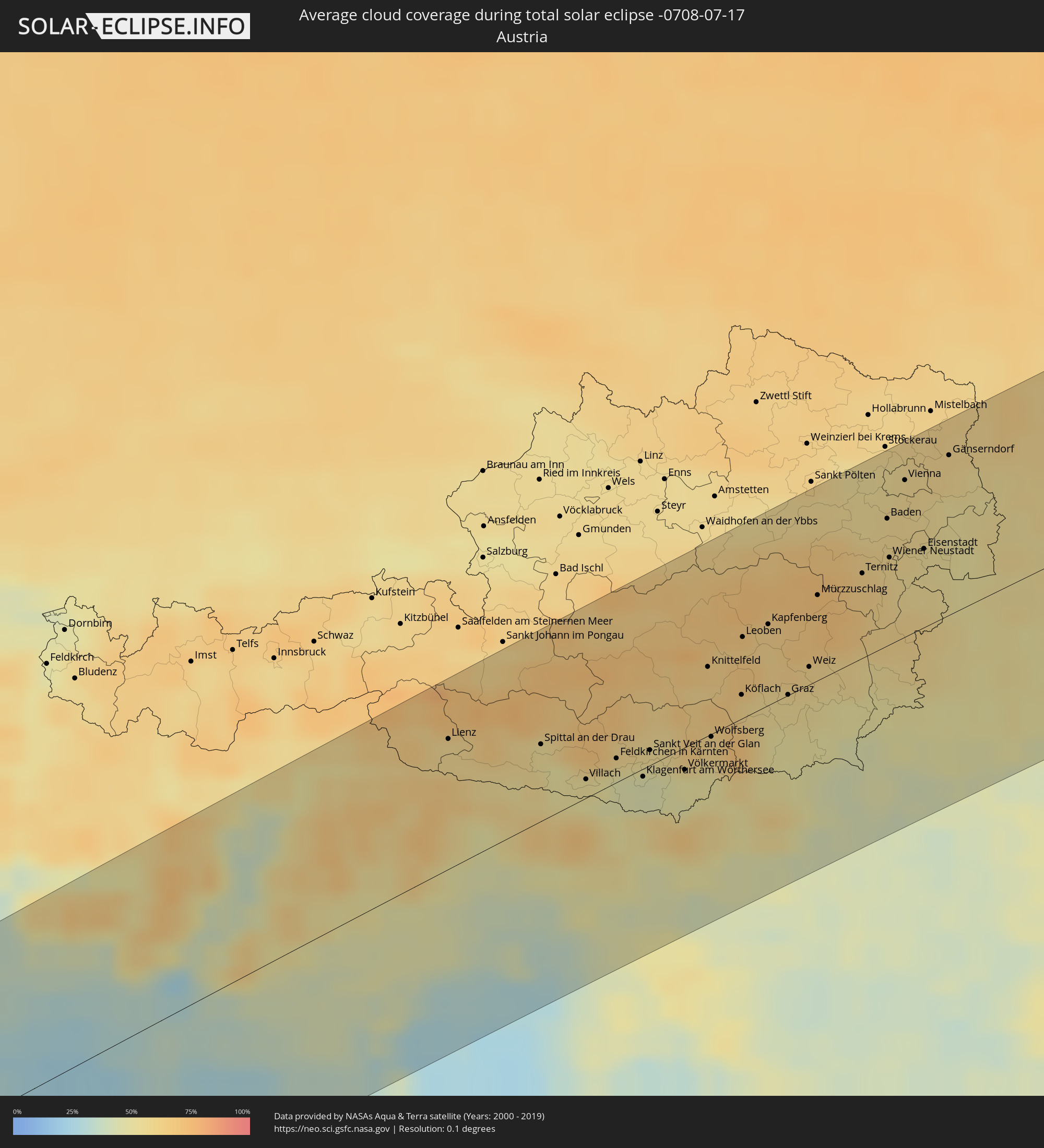 Austria
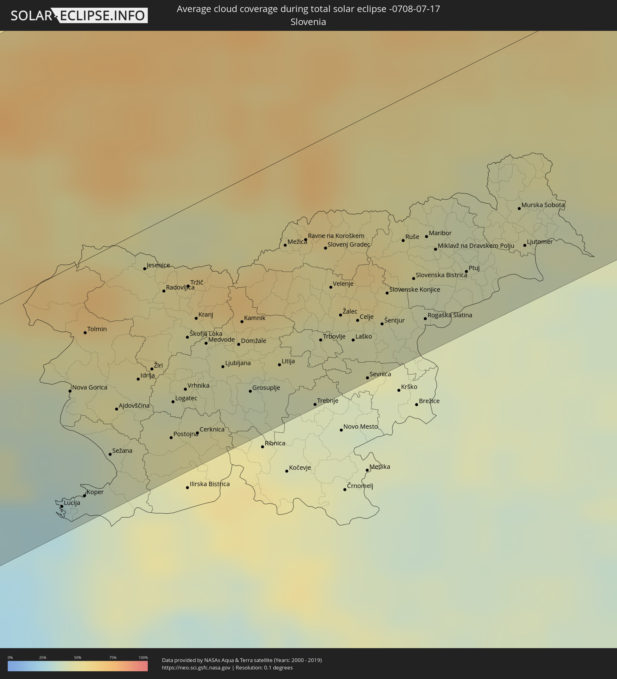 Slovenia
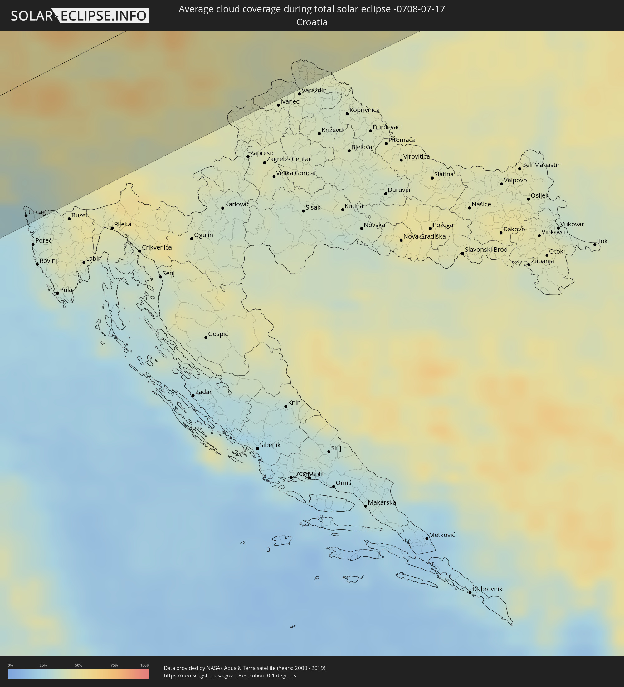 Croatia
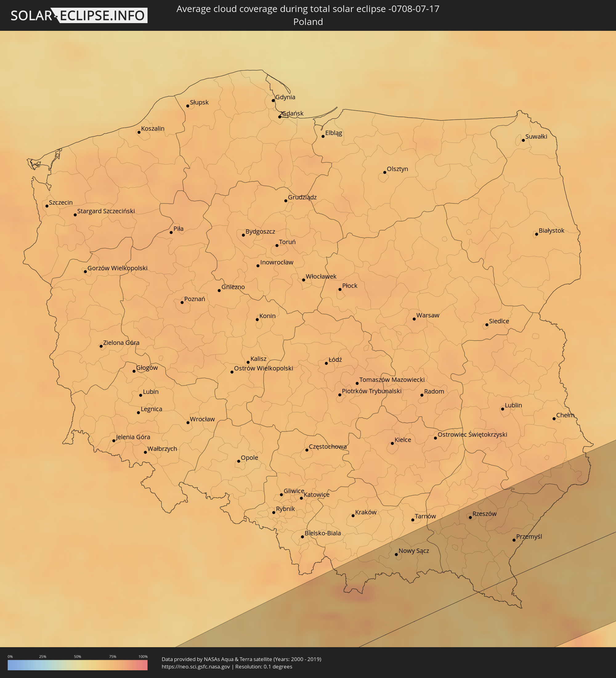 Poland
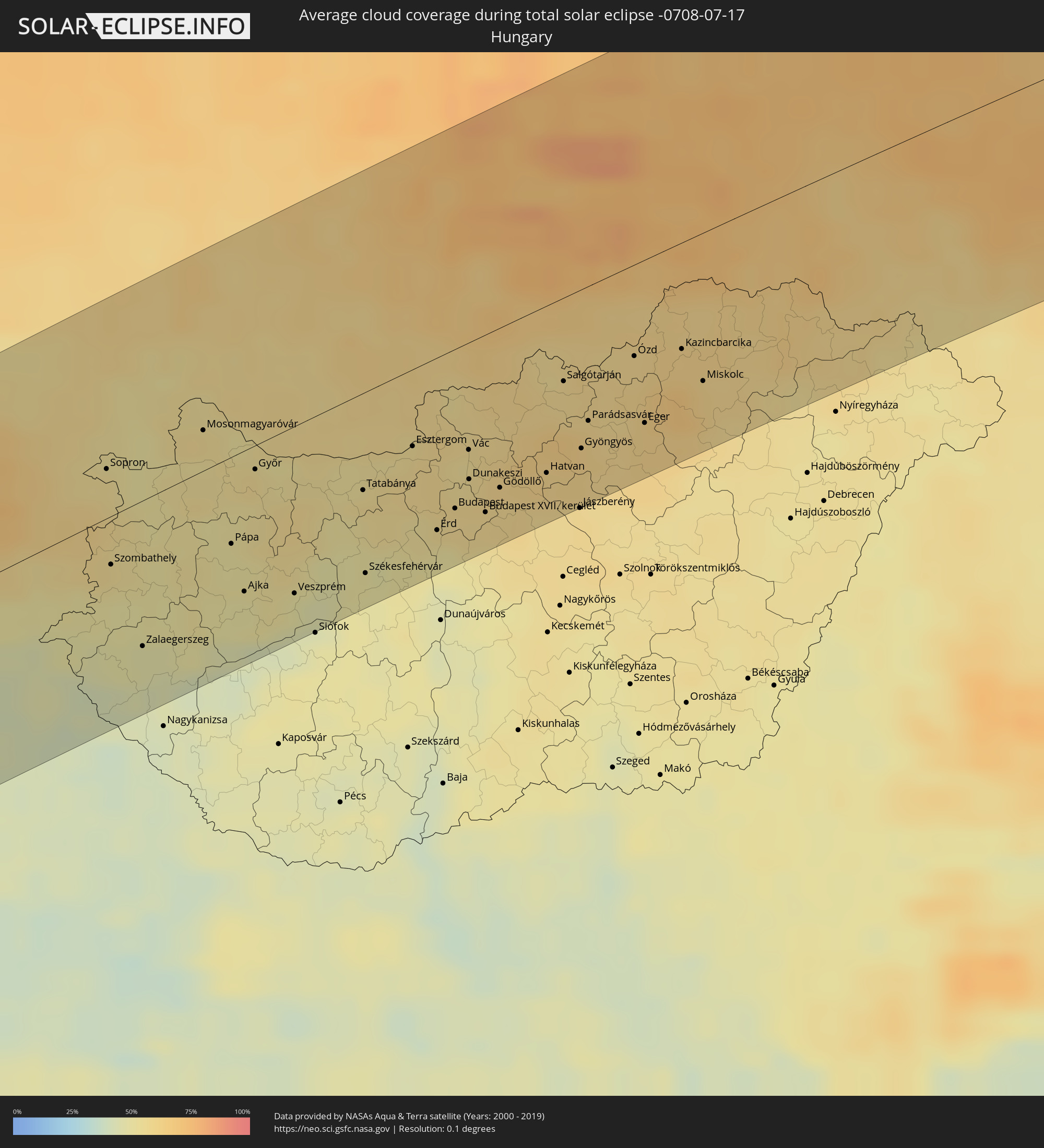 Hungary
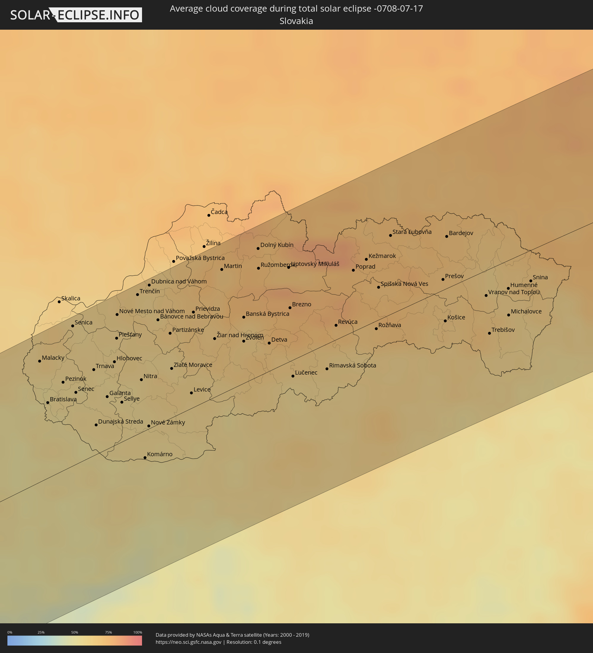 Slovakia
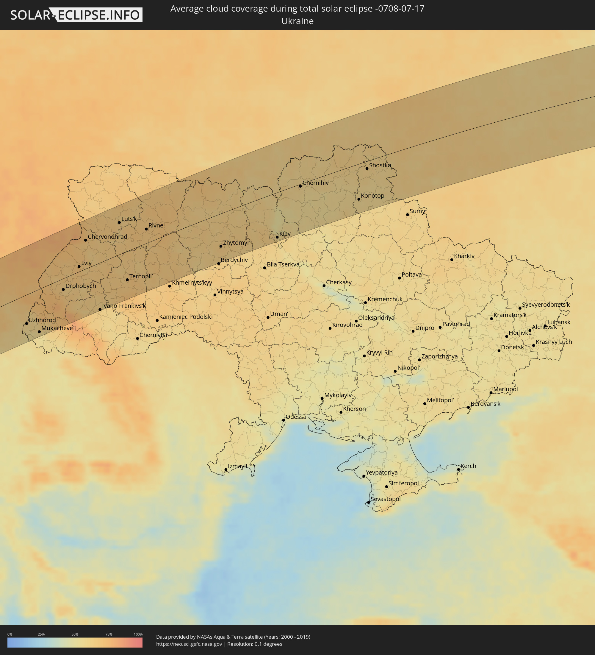 Ukraine
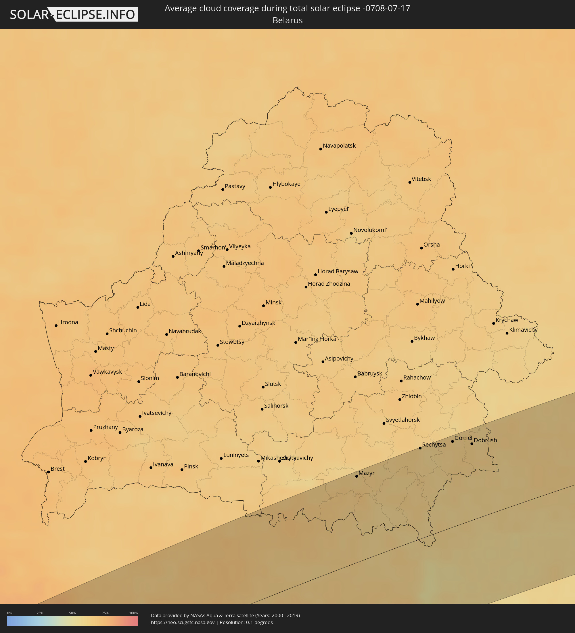 Belarus
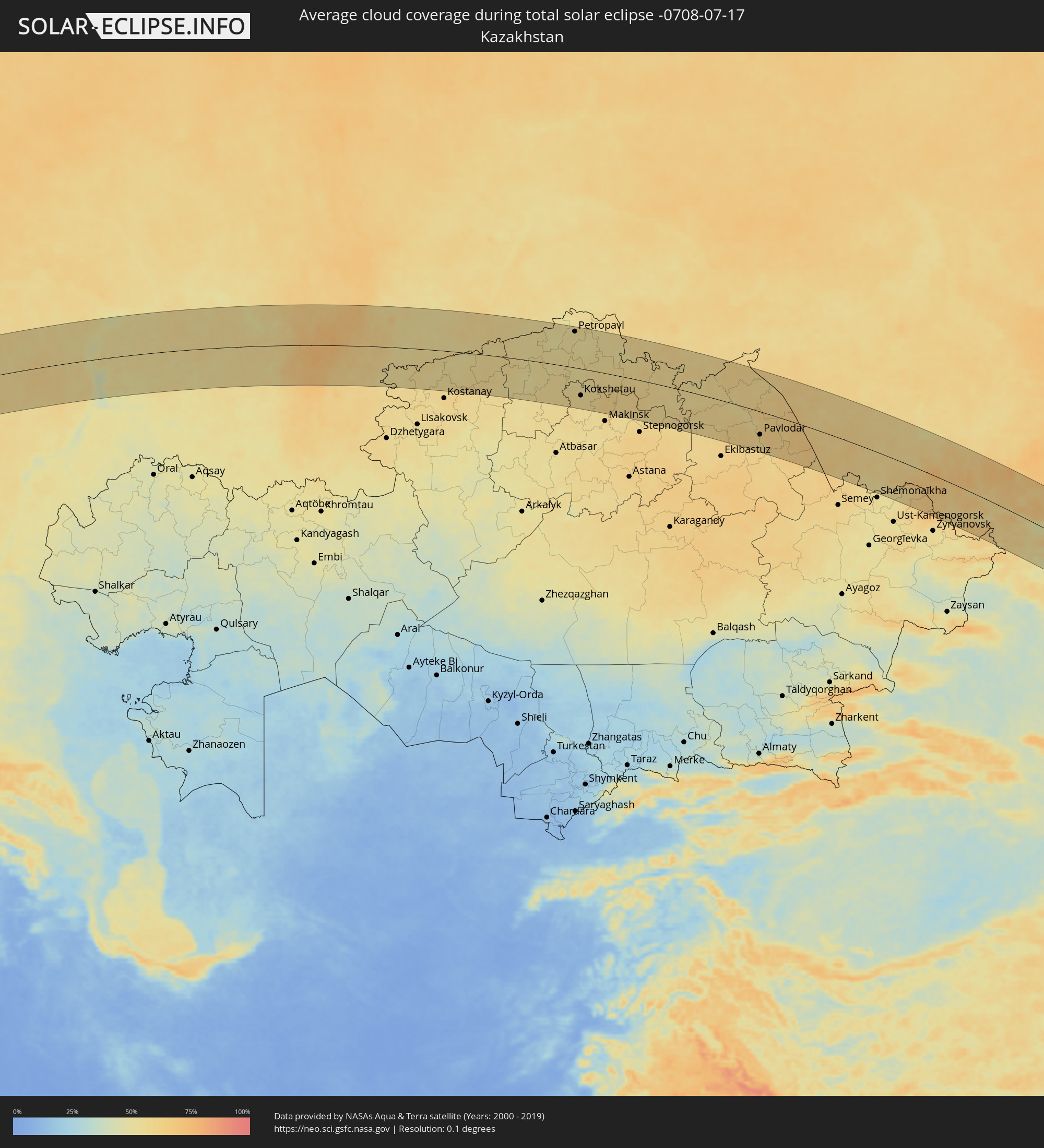 Kazakhstan
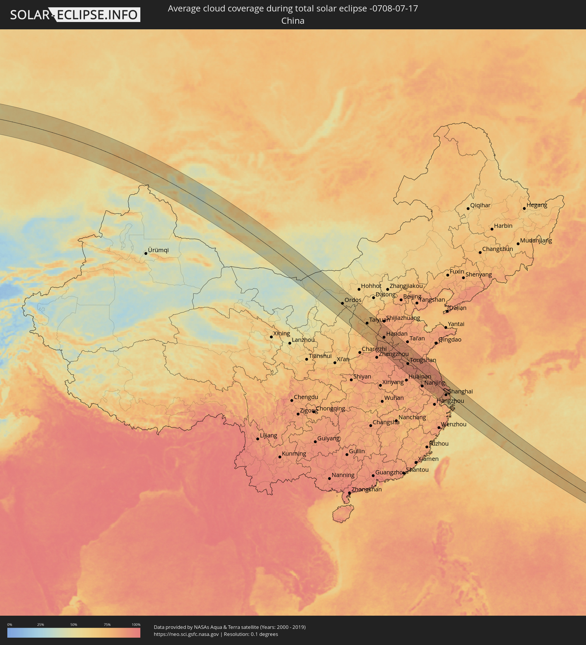 China
China
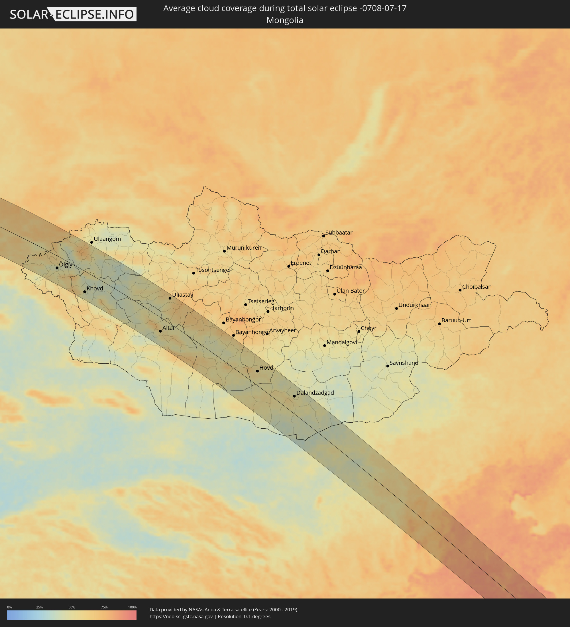 Mongolia
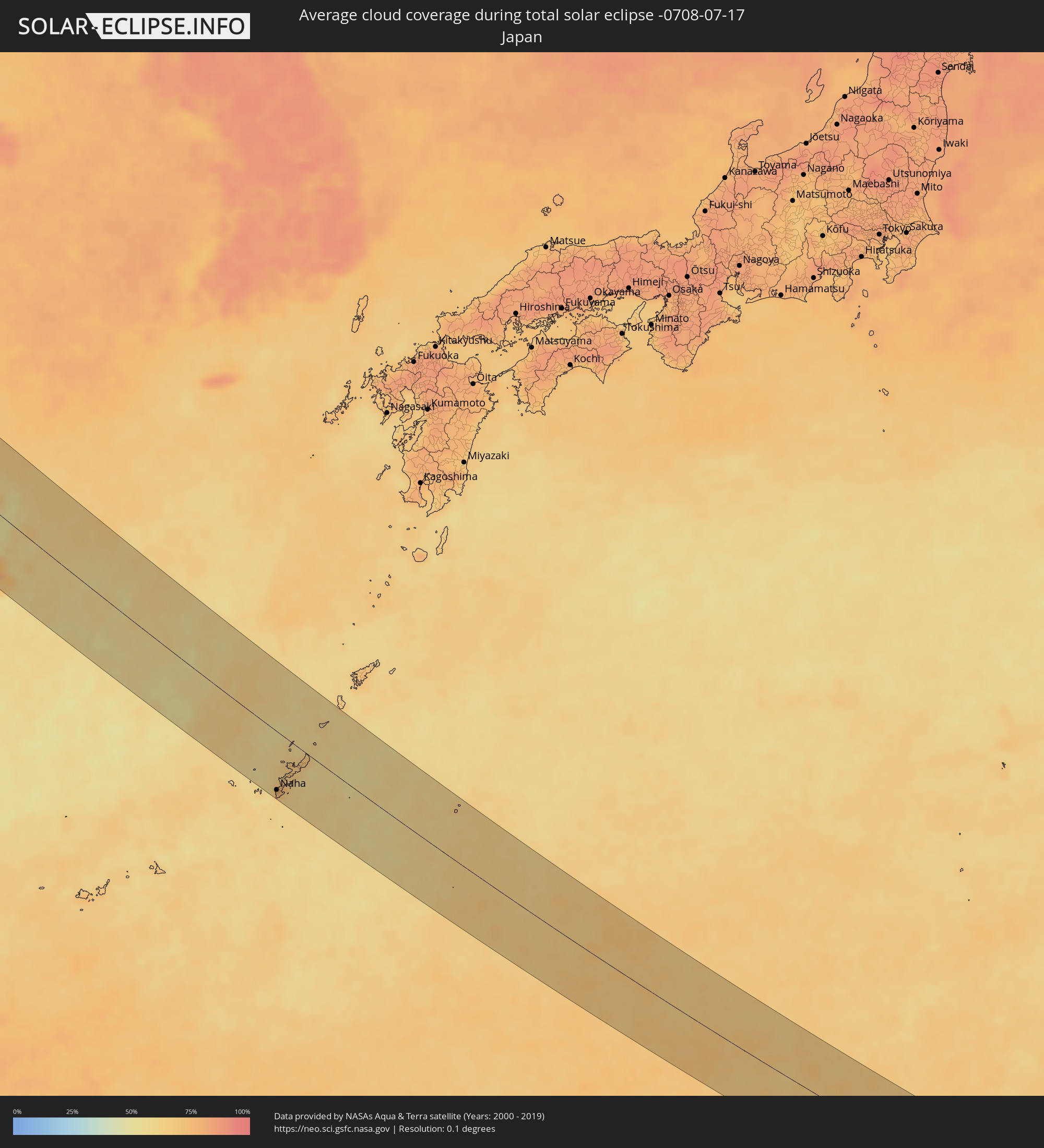 Japan
Japan
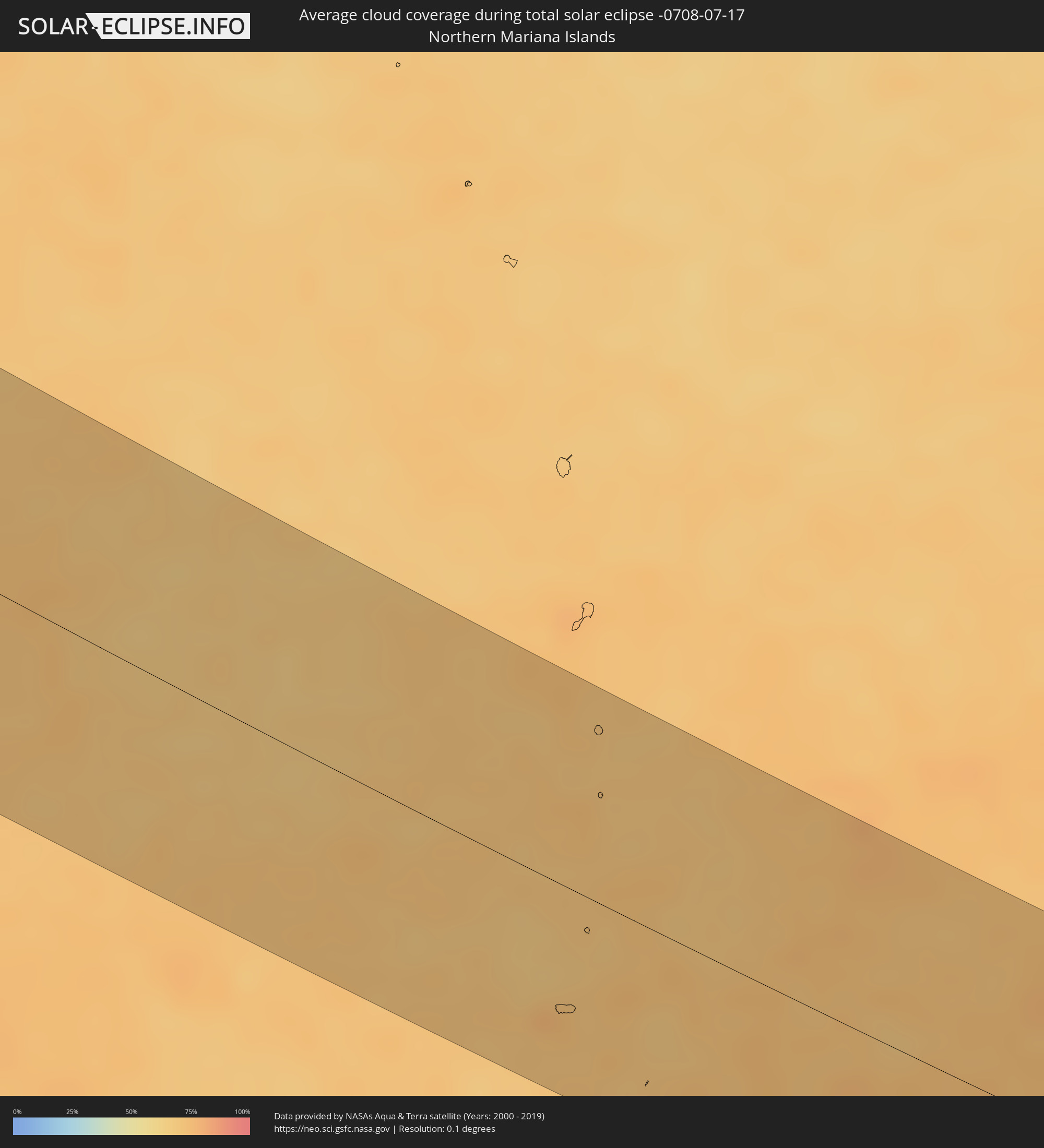 Northern Mariana Islands
Cities inside the path of the eclipse
The following table shows all locations with a population of more than 5,000 inside the eclipse path. Cities which have more than 100,000 inhabitants are marked bold. A click at the locations opens a detailed map.
| City | Type | Eclipse duration | Local time of max. eclipse | Distance to central line | Ø Cloud coverage |
|
Sines, Setúbal
|
total | - | 04:42:30 UTC-00:36 | 75 km | 31% |
|
Santo André, Setúbal
|
total | - | 04:42:33 UTC-00:36 | 79 km | 19% |
|
Santiago do Cacém, Setúbal
|
total | - | 04:42:30 UTC-00:36 | 73 km | 12% |
|
Grândola, Setúbal
|
total | - | 04:42:35 UTC-00:36 | 84 km | 15% |
|
Évora, Évora
|
total | - | 04:42:41 UTC-00:36 | 93 km | 11% |
|
Beja, Beja
|
total | - | 04:42:11 UTC-00:36 | 40 km | 9% |
|
Moncarapacho, Faro
|
total | - | 04:41:20 UTC-00:36 | 57 km | 16% |
|
Tavira, Faro
|
total | - | 04:41:19 UTC-00:36 | 59 km | 16% |
|
Moura, Beja
|
total | - | 04:42:08 UTC-00:36 | 39 km | 8% |
|
Vila Real de Santo António, Faro
|
total | - | 04:41:18 UTC-00:36 | 67 km | 16% |
|
Elvas, Portalegre
|
total | - | 04:42:42 UTC-00:36 | 92 km | 12% |
|
Badajoz, Extremadura
|
total | - | 05:19:23 UTC+00:00 | 82 km | 12% |
|
Huelva, Andalusia
|
total | - | 05:17:56 UTC+00:00 | 77 km | 9% |
|
Móstoles, Madrid
|
total | - | 05:19:47 UTC+00:00 | 91 km | 11% |
|
Madrid, Madrid
|
total | - | 05:19:50 UTC+00:00 | 93 km | 12% |
|
Alcalá de Henares, Madrid
|
total | - | 05:19:48 UTC+00:00 | 84 km | 13% |
|
Zaragoza, Aragon
|
total | - | 05:20:25 UTC+00:00 | 95 km | 23% |
|
Lleida, Catalonia
|
total | - | 05:20:06 UTC+00:00 | 35 km | 20% |
|
Tarragona, Catalonia
|
total | - | 05:19:28 UTC+00:00 | 46 km | 30% |
|
Sant Julià de Lòria, Sant Julià de Loria
|
total | - | 05:20:51 UTC+00:00 | 75 km | 32% |
|
la Massana, La Massana
|
total | - | 05:20:56 UTC+00:00 | 81 km | 32% |
|
Andorra la Vella, Andorra la Vella
|
total | - | 05:20:54 UTC+00:00 | 78 km | 32% |
|
Ordino, Ordino
|
total | - | 05:20:57 UTC+00:00 | 82 km | 39% |
|
les Escaldes, Escaldes-Engordany
|
total | - | 05:20:54 UTC+00:00 | 77 km | 32% |
|
Encamp, Encamp
|
total | - | 05:20:55 UTC+00:00 | 78 km | 33% |
|
Canillo, Canillo
|
total | - | 05:20:57 UTC+00:00 | 81 km | 37% |
|
Terrassa, Catalonia
|
total | - | 05:19:49 UTC+00:00 | 38 km | 32% |
|
Barcelona, Catalonia
|
total | - | 05:19:37 UTC+00:00 | 59 km | 32% |
|
Mataró, Catalonia
|
total | - | 05:19:44 UTC+00:00 | 55 km | 29% |
|
Perpignan, Occitania
|
total | - | 05:30:16 UTC+00:09 | 43 km | 36% |
|
Béziers, Occitania
|
total | - | 05:30:57 UTC+00:09 | 93 km | 36% |
|
Montpellier, Occitania
|
total | - | 05:31:11 UTC+00:09 | 90 km | 39% |
|
Nîmes, Occitania
|
total | - | 05:31:24 UTC+00:09 | 93 km | 33% |
|
Arles, Provence-Alpes-Côte d'Azur
|
total | - | 05:31:12 UTC+00:09 | 67 km | 29% |
|
Avignon, Provence-Alpes-Côte d'Azur
|
total | - | 05:31:30 UTC+00:09 | 86 km | 29% |
|
Marseille, Provence-Alpes-Côte d'Azur
|
total | - | 05:30:44 UTC+00:09 | 0 km | 32% |
|
Aix-en-Provence, Provence-Alpes-Côte d'Azur
|
total | - | 05:30:59 UTC+00:09 | 20 km | 24% |
|
Toulon, Provence-Alpes-Côte d'Azur
|
total | - | 05:30:30 UTC+00:09 | 39 km | 36% |
|
Antibes, Provence-Alpes-Côte d'Azur
|
total | - | 05:30:59 UTC+00:09 | 42 km | 34% |
|
Nice, Provence-Alpes-Côte d'Azur
|
total | - | 05:31:08 UTC+00:09 | 33 km | 34% |
|
Monaco
|
total | - | 05:31:10 UTC+00:09 | 36 km | 32% |
|
La Condamine
|
total | - | 05:31:10 UTC+00:09 | 36 km | 32% |
|
Monte-Carlo
|
total | - | 05:31:11 UTC+00:09 | 36 km | 32% |
|
Turin, Piedmont
|
total | - | 06:23:23 UTC+01:00 | 84 km | 38% |
|
Genoa, Liguria
|
total | - | 06:22:39 UTC+01:00 | 25 km | 37% |
|
Milan, Lombardy
|
total | - | 06:23:54 UTC+01:00 | 66 km | 33% |
|
Brescia, Lombardy
|
total | - | 06:24:03 UTC+01:00 | 35 km | 33% |
|
Parma, Emilia-Romagna
|
total | - | 06:23:10 UTC+01:00 | 41 km | 29% |
|
Reggio nell'Emilia, Emilia-Romagna
|
total | - | 06:23:05 UTC+01:00 | 63 km | 28% |
|
Modena, Emilia-Romagna
|
total | - | 06:23:02 UTC+01:00 | 79 km | 30% |
|
Verona, Veneto
|
total | - | 06:23:59 UTC+01:00 | 4 km | 34% |
|
Padova, Veneto
|
total | - | 06:24:03 UTC+01:00 | 39 km | 43% |
|
Mestre, Veneto
|
total | - | 06:24:12 UTC+01:00 | 43 km | 40% |
|
Spittal an der Drau, Carinthia
|
total | - | 06:25:59 UTC+01:00 | 41 km | 54% |
|
Umag, Istarska
|
total | - | 06:24:18 UTC+01:00 | 95 km | 30% |
|
Nova Gorica, Nova Gorica
|
total | - | 06:24:58 UTC+01:00 | 48 km | 39% |
|
Koper, Koper-Capodistria
|
total | - | 06:24:29 UTC+01:00 | 91 km | 34% |
|
Trieste, Friuli Venezia Giulia
|
total | - | 06:24:36 UTC+01:00 | 84 km | 35% |
|
Villach, Carinthia
|
total | - | 06:25:49 UTC+01:00 | 10 km | 48% |
|
Jesenice, Jesenice
|
total | - | 06:25:37 UTC+01:00 | 15 km | 51% |
|
Klagenfurt am Wörthersee, Carinthia
|
total | - | 06:25:54 UTC+01:00 | 4 km | 45% |
|
Kranj, Kranj
|
total | - | 06:25:26 UTC+01:00 | 44 km | 46% |
|
Ljubljana, Ljubljana
|
total | - | 06:25:14 UTC+01:00 | 68 km | 45% |
|
Kamnik, Kamnik
|
total | - | 06:25:28 UTC+01:00 | 54 km | 49% |
|
Wolfsberg, Carinthia
|
total | - | 06:26:17 UTC+01:00 | 14 km | 54% |
|
Trbovlje, Trbovlje
|
total | - | 06:25:28 UTC+01:00 | 77 km | 46% |
|
Leoben, Styria
|
total | - | 06:27:00 UTC+01:00 | 43 km | 64% |
|
Velenje, Velenje
|
total | - | 06:25:44 UTC+01:00 | 62 km | 50% |
|
Celje, Celje
|
total | - | 06:25:36 UTC+01:00 | 78 km | 44% |
|
Kapfenberg, Styria
|
total | - | 06:27:08 UTC+01:00 | 43 km | 61% |
|
Graz, Styria
|
total | - | 06:26:41 UTC+01:00 | 0 km | 55% |
|
Maribor, Maribor
|
total | - | 06:26:05 UTC+01:00 | 57 km | 49% |
|
Ptuj, Ptuj
|
total | - | 06:25:58 UTC+01:00 | 78 km | 44% |
|
Ternitz, Lower Austria
|
total | - | 06:27:38 UTC+01:00 | 45 km | 63% |
|
Baden, Lower Austria
|
total | - | 06:28:03 UTC+01:00 | 67 km | 58% |
|
Wiener Neustadt, Lower Austria
|
total | - | 06:27:48 UTC+01:00 | 46 km | 57% |
|
Vienna, Vienna
|
total | - | 06:28:21 UTC+01:00 | 83 km | 58% |
|
Čakovec, Međimurska
|
total | - | 06:26:03 UTC+01:00 | 101 km | 40% |
|
Sopron, Győr-Moson-Sopron
|
total | - | 06:27:44 UTC+01:00 | 23 km | 55% |
|
Szombathely, Vas
|
total | - | 06:27:10 UTC+01:00 | 23 km | 53% |
|
Zalaegerszeg, Zala
|
total | - | 06:26:44 UTC+01:00 | 69 km | 47% |
|
Bratislava, Bratislavský
|
total | - | 06:28:27 UTC+01:00 | 52 km | 55% |
|
Trnava, Trnavský
|
total | - | 06:28:52 UTC+01:00 | 60 km | 58% |
|
Győr, Győr-Moson-Sopron
|
total | - | 06:28:00 UTC+01:00 | 11 km | 56% |
|
Veszprém, Veszprém
|
total | - | 06:27:20 UTC+01:00 | 80 km | 48% |
|
Trenčín, Trenčiansky
|
total | - | 06:29:40 UTC+01:00 | 97 km | 64% |
|
Nitra, Nitriansky
|
total | - | 06:28:55 UTC+01:00 | 37 km | 58% |
|
Tatabánya, Komárom-Esztergom
|
total | - | 06:28:05 UTC+01:00 | 46 km | 56% |
|
Székesfehérvár, Fejér
|
total | - | 06:27:36 UTC+01:00 | 86 km | 49% |
|
Prievidza, Nitriansky
|
total | - | 06:29:41 UTC+01:00 | 66 km | 66% |
|
Martin, Žilinský
|
total | - | 06:30:09 UTC+01:00 | 86 km | 68% |
|
Budapest, Budapest
|
total | - | 06:28:11 UTC+01:00 | 76 km | 56% |
|
Zvolen, Banskobystrický
|
total | - | 06:29:35 UTC+01:00 | 29 km | 63% |
|
Banská Bystrica, Banskobystrický
|
total | - | 06:29:48 UTC+01:00 | 46 km | 63% |
|
Budapest XVII. kerület, Budapest
|
total | - | 06:28:13 UTC+01:00 | 84 km | 57% |
|
Zakopane, Lesser Poland Voivodeship
|
total | - | 06:54:47 UTC+01:24 | 77 km | 82% |
|
Parádsasvár, Heves
|
total | - | 06:29:00 UTC+01:00 | 64 km | 60% |
|
Nowy Targ, Lesser Poland Voivodeship
|
total | - | 06:55:03 UTC+01:24 | 93 km | 72% |
|
Poprad, Prešovský
|
total | - | 06:30:36 UTC+01:00 | 42 km | 74% |
|
Nowy Sącz, Lesser Poland Voivodeship
|
total | - | 06:55:28 UTC+01:24 | 88 km | 70% |
|
Miskolc, Borsod-Abaúj-Zemplén
|
total | - | 06:29:32 UTC+01:00 | 71 km | 61% |
|
Gorlice, Lesser Poland Voivodeship
|
total | - | 06:55:40 UTC+01:24 | 76 km | 69% |
|
Prešov, Prešovský
|
total | - | 06:30:51 UTC+01:00 | 7 km | 68% |
|
Košice, Košický
|
total | - | 06:30:29 UTC+01:00 | 25 km | 65% |
|
Jasło, Subcarpathian Voivodeship
|
total | - | 06:55:54 UTC+01:24 | 75 km | 70% |
|
Krosno, Subcarpathian Voivodeship
|
total | - | 06:55:57 UTC+01:24 | 61 km | 72% |
|
Rzeszów, Subcarpathian Voivodeship
|
total | - | 06:56:30 UTC+01:24 | 90 km | 75% |
|
Sanok, Subcarpathian Voivodeship
|
total | - | 06:55:57 UTC+01:24 | 35 km | 73% |
|
Uzhhorod, Zakarpattia
|
total | - | 07:32:50 UTC+02:02 | 64 km | 57% |
|
Jarosław, Subcarpathian Voivodeship
|
total | - | 06:56:44 UTC+01:24 | 67 km | 76% |
|
Przemyśl, Subcarpathian Voivodeship
|
total | - | 06:56:28 UTC+01:24 | 41 km | 71% |
|
Tomaszów Lubelski, Lublin Voivodeship
|
total | - | 06:57:36 UTC+01:24 | 90 km | 77% |
|
Lviv, Lviv
|
total | - | 07:35:08 UTC+02:02 | 12 km | 69% |
|
Ivano-Frankivs’k, Ivano-Frankivsk
|
total | - | 07:34:16 UTC+02:02 | 104 km | 63% |
|
Luts’k, Volyn
|
total | - | 07:36:57 UTC+02:02 | 70 km | 66% |
|
Ternopil’, Ternopil
|
total | - | 07:35:31 UTC+02:02 | 66 km | 67% |
|
Rivne, Rivne
|
total | - | 07:37:12 UTC+02:02 | 31 km | 68% |
|
Zhytomyr, Zhytomyr
|
total | - | 07:38:04 UTC+02:02 | 71 km | 66% |
|
Mazyr, Gomel
|
total | - | 07:28:37 UTC+01:50 | 102 km | 65% |
|
Khoyniki, Gomel
|
total | - | 07:28:49 UTC+01:50 | 66 km | 63% |
|
Rechytsa, Gomel
|
total | - | 07:29:41 UTC+01:50 | 105 km | 62% |
|
Kiev, Kyiv City
|
total | - | 07:39:25 UTC+02:02 | 97 km | 63% |
|
Loyew, Gomel
|
total | - | 07:41:28 UTC+02:02 | 52 km | 61% |
|
Brovary, Kiev
|
total | - | 07:39:40 UTC+02:02 | 98 km | 61% |
|
Gomel, Gomel
|
total | - | 07:30:08 UTC+01:50 | 99 km | 63% |
|
Chernihiv, Chernihiv
|
total | - | 07:41:13 UTC+02:02 | 18 km | 60% |
|
Dobrush, Gomel
|
total | - | 07:30:19 UTC+01:50 | 90 km | 64% |
|
Konotop, Sumy
|
total | - | 07:42:10 UTC+02:02 | 77 km | 58% |
|
Orël, Orjol
|
total | - | 08:14:34 UTC+02:30 | 47 km | 67% |
|
Kursk, Kursk
|
total | - | 08:13:11 UTC+02:30 | 86 km | 64% |
|
Lipetsk, Lipetsk
|
total | - | 08:16:56 UTC+02:30 | 55 km | 66% |
|
Tambov, Tambov
|
total | - | 08:18:44 UTC+02:30 | 72 km | 61% |
|
Penza, Penza
|
total | - | 08:22:35 UTC+02:30 | 69 km | 60% |
|
Saransk, Mordoviya
|
total | - | 08:23:44 UTC+02:30 | 41 km | 55% |
|
Ulyanovsk, Ulyanovsk
|
total | - | 09:17:07 UTC+03:20 | 21 km | 53% |
|
Tol’yatti, Samara
|
total | - | 09:17:26 UTC+03:20 | 77 km | 47% |
|
Sterlitamak, Bashkortostan
|
total | - | 10:07:21 UTC+04:02 | 99 km | 57% |
|
Ufa, Bashkortostan
|
total | - | 10:08:03 UTC+04:02 | 25 km | 57% |
|
Chelyabinsk, Chelyabinsk
|
total | - | 10:14:54 UTC+04:02 | 75 km | 63% |
|
Komsomolets, Qostanay
|
total | - | 10:34:32 UTC+04:21 | 80 km | 57% |
|
Borovskoy, Qostanay
|
total | - | 10:37:23 UTC+04:21 | 65 km | 55% |
|
Petropavl, Soltüstik Qazaqstan
|
total | - | 10:44:10 UTC+04:21 | 97 km | 55% |
|
Kokshetau, Aqmola
|
total | - | 10:44:34 UTC+04:21 | 74 km | 56% |
|
Taiynsha, Soltüstik Qazaqstan
|
total | - | 10:45:03 UTC+04:21 | 7 km | 56% |
|
Shchuchinsk, Aqmola
|
total | - | 10:45:43 UTC+04:21 | 102 km | 57% |
|
Irtyshsk, Pavlodar
|
total | - | 10:53:12 UTC+04:21 | 23 km | 56% |
|
Qashyr, Pavlodar
|
total | - | 10:54:14 UTC+04:21 | 7 km | 55% |
|
Aksu, Pavlodar
|
total | - | 10:55:53 UTC+04:21 | 90 km | 60% |
|
Pavlodar, Pavlodar
|
total | - | 10:55:50 UTC+04:21 | 65 km | 62% |
|
Ridder, East Kazakhstan
|
total | - | 11:06:56 UTC+04:21 | 111 km | 60% |
|
Ölgiy, Bayan-Ölgiy
|
total | - | 13:02:39 UTC+06:06 | 51 km | 44% |
|
Khovd, Hovd
|
total | - | 13:06:16 UTC+06:06 | 83 km | 44% |
|
Altai, Govĭ-Altay
|
total | - | 13:14:59 UTC+06:06 | 56 km | 54% |
|
Uliastay, Dzabkhan
|
total | - | 13:13:47 UTC+06:06 | 98 km | 55% |
|
Hovd, Övörhangay
|
total | - | 14:26:11 UTC+07:07 | 61 km | 53% |
|
Dalandzadgad, Ömnögovĭ
|
total | - | 14:30:40 UTC+07:07 | 69 km | 49% |
|
Ordos, Inner Mongolia
|
total | - | 15:35:41 UTC+08:00 | 26 km | 60% |
|
Baotou, Inner Mongolia
|
total | - | 15:33:55 UTC+08:00 | 99 km | 57% |
|
Taiyuan, Shanxi
|
total | - | 15:41:21 UTC+08:00 | 17 km | 68% |
|
Handan, Hebei
|
total | - | 15:45:11 UTC+08:00 | 26 km | 80% |
|
Huaibei, Anhui
|
total | - | 15:51:30 UTC+08:00 | 74 km | 88% |
|
Tongshan, Jiangsu
|
total | - | 15:51:25 UTC+08:00 | 34 km | 86% |
|
Changzhou, Jiangsu
|
total | - | 15:57:17 UTC+08:00 | 69 km | 87% |
|
Wuxi, Jiangsu
|
total | - | 15:57:49 UTC+08:00 | 72 km | 84% |
|
Suzhou, Jiangsu
|
total | - | 15:58:26 UTC+08:00 | 71 km | 84% |
|
Changshu City, Jiangsu
|
total | - | 15:57:57 UTC+08:00 | 32 km | 84% |
|
Shanghai, Shanghai
|
total | - | 15:59:03 UTC+08:00 | 30 km | 84% |
|
Itoman, Okinawa
|
total | - | 17:09:31 UTC+09:00 | 102 km | 63% |
|
Tomigusuku, Okinawa
|
total | - | 17:09:26 UTC+09:00 | 96 km | 74% |
|
Naha, Okinawa
|
total | - | 17:09:23 UTC+09:00 | 93 km | 74% |
|
Ginowan, Okinawa
|
total | - | 17:09:21 UTC+09:00 | 84 km | 73% |
|
Chatan, Okinawa
|
total | - | 17:09:17 UTC+09:00 | 80 km | 73% |
|
Okinawa, Okinawa
|
total | - | 17:09:15 UTC+09:00 | 75 km | 73% |
|
Ishikawa, Okinawa
|
total | - | 17:09:08 UTC+09:00 | 66 km | 75% |
|
Gushikawa, Okinawa
|
total | - | 17:09:14 UTC+09:00 | 69 km | 69% |
|
Katsuren-haebaru, Okinawa
|
total | - | 17:09:17 UTC+09:00 | 71 km | 67% |
|
Nago, Okinawa
|
total | - | 17:08:54 UTC+09:00 | 40 km | 68% |