Total solar eclipse of 02/23/-1658
| Day of week: | Sunday |
| Maximum duration of eclipse: | 03m48s |
| Maximum width of eclipse path: | 165 km |
| Saros cycle: | 23 |
| Coverage: | 100% |
| Magnitude: | 1.0425 |
| Gamma: | 0.525 |
Wo kann man die Sonnenfinsternis vom 02/23/-1658 sehen?
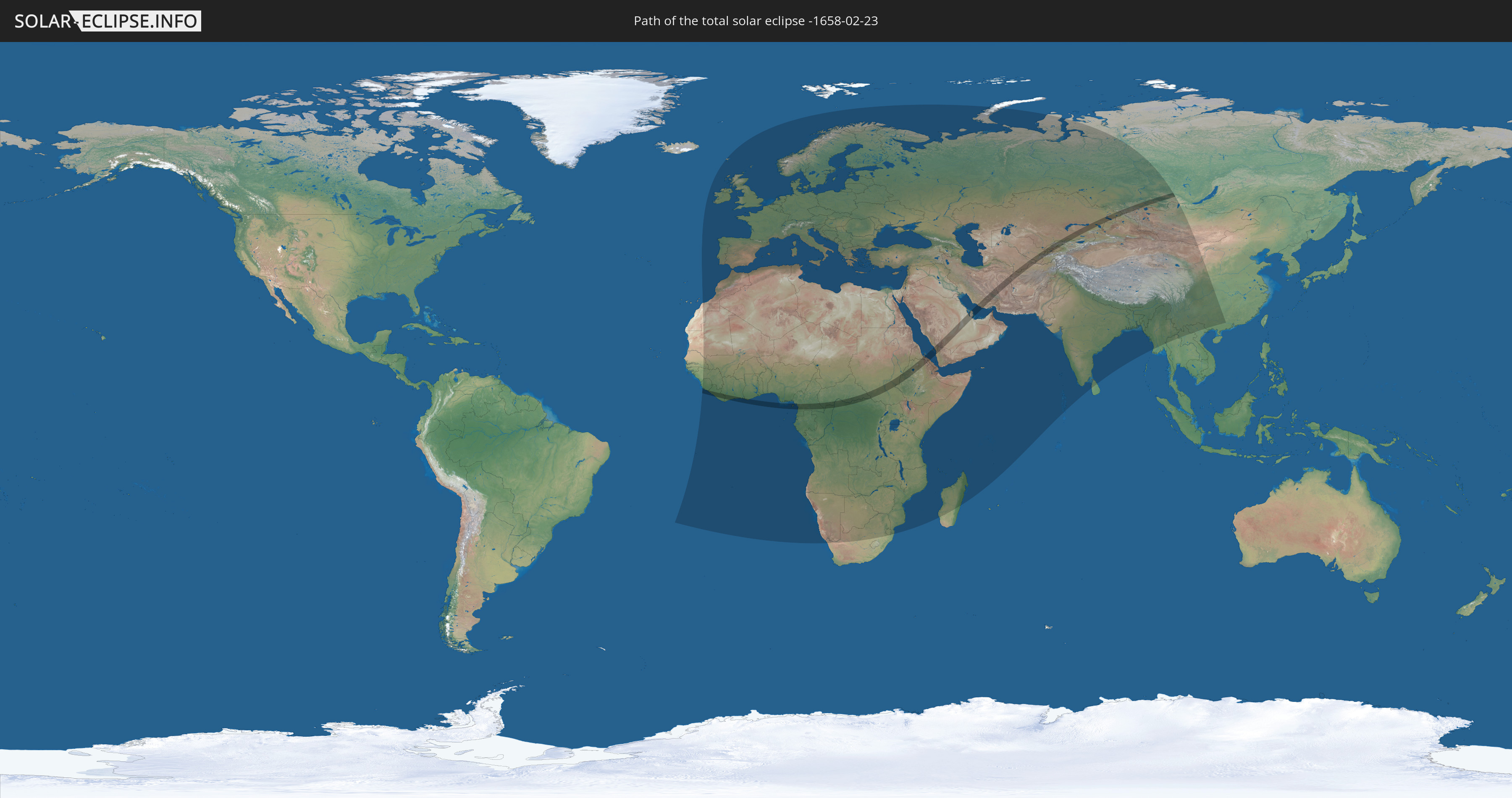
Die Sonnenfinsternis am 02/23/-1658 kann man in 139 Ländern als partielle Sonnenfinsternis beobachten.
Der Finsternispfad verläuft durch 28 Länder. Nur in diesen Ländern ist sie als total Sonnenfinsternis zu sehen.
In den folgenden Ländern ist die Sonnenfinsternis total zu sehen
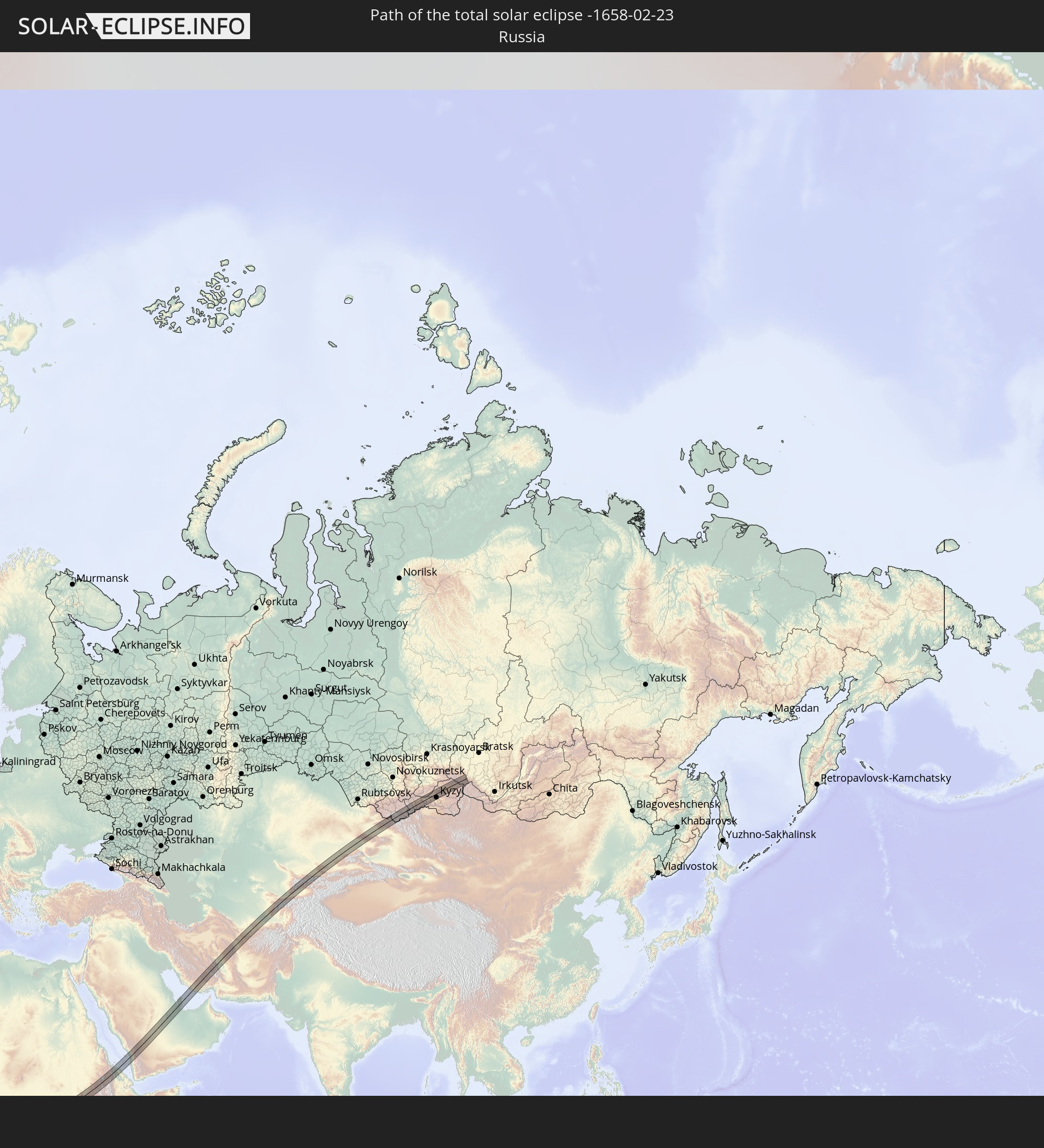 Russia
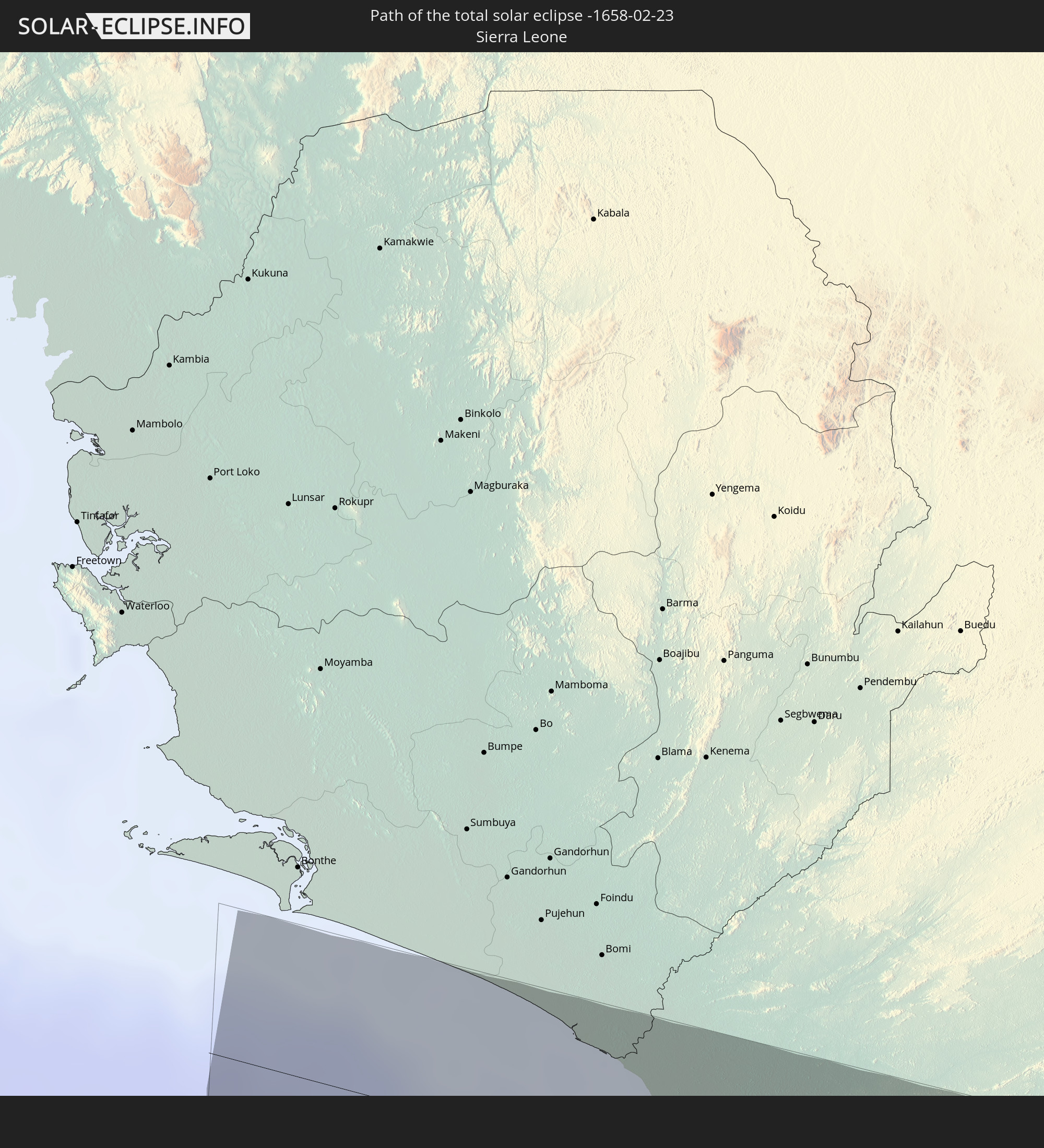 Sierra Leone
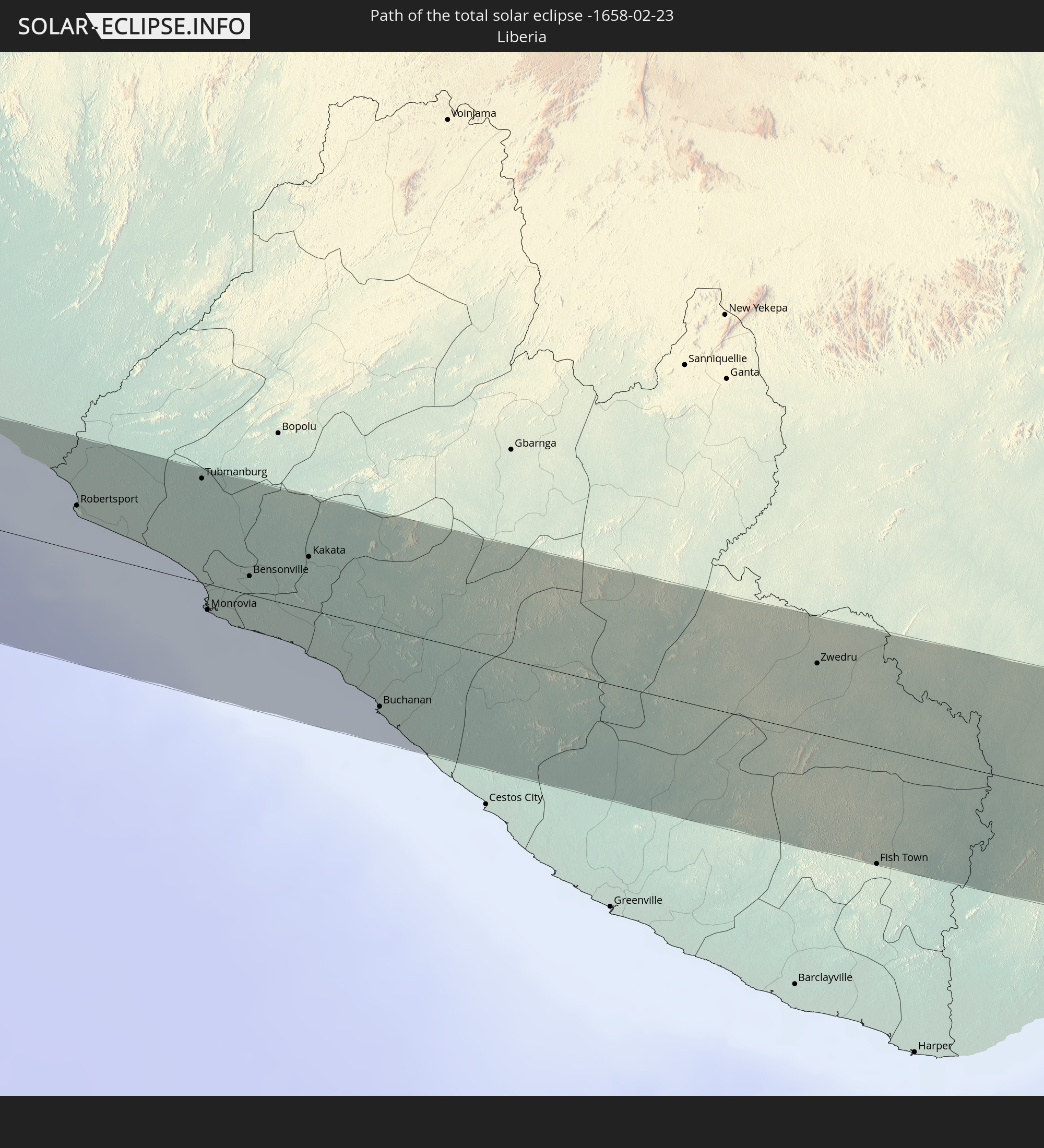 Liberia
 Ivory Coast
 Ghana
Ghana
 Equatorial Guinea
 Cameroon
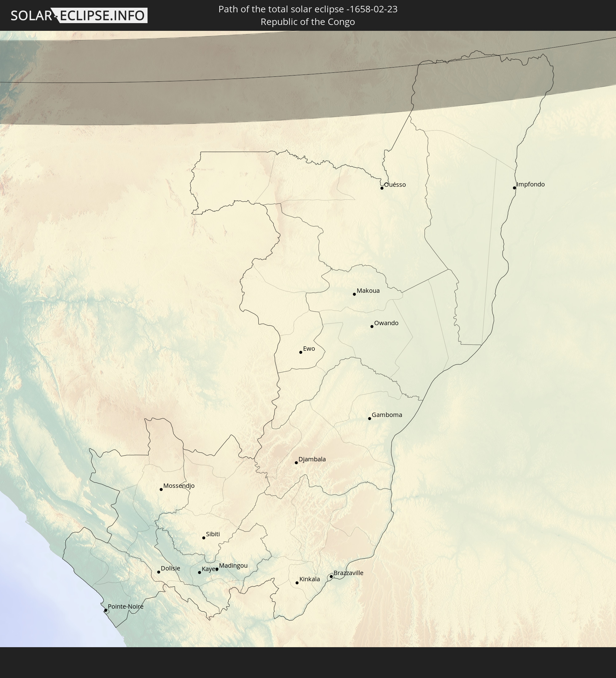 Republic of the Congo
 Democratic Republic of the Congo
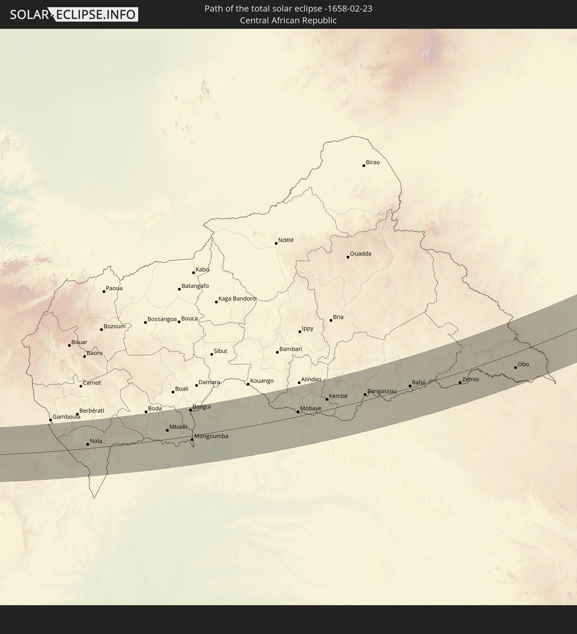 Central African Republic
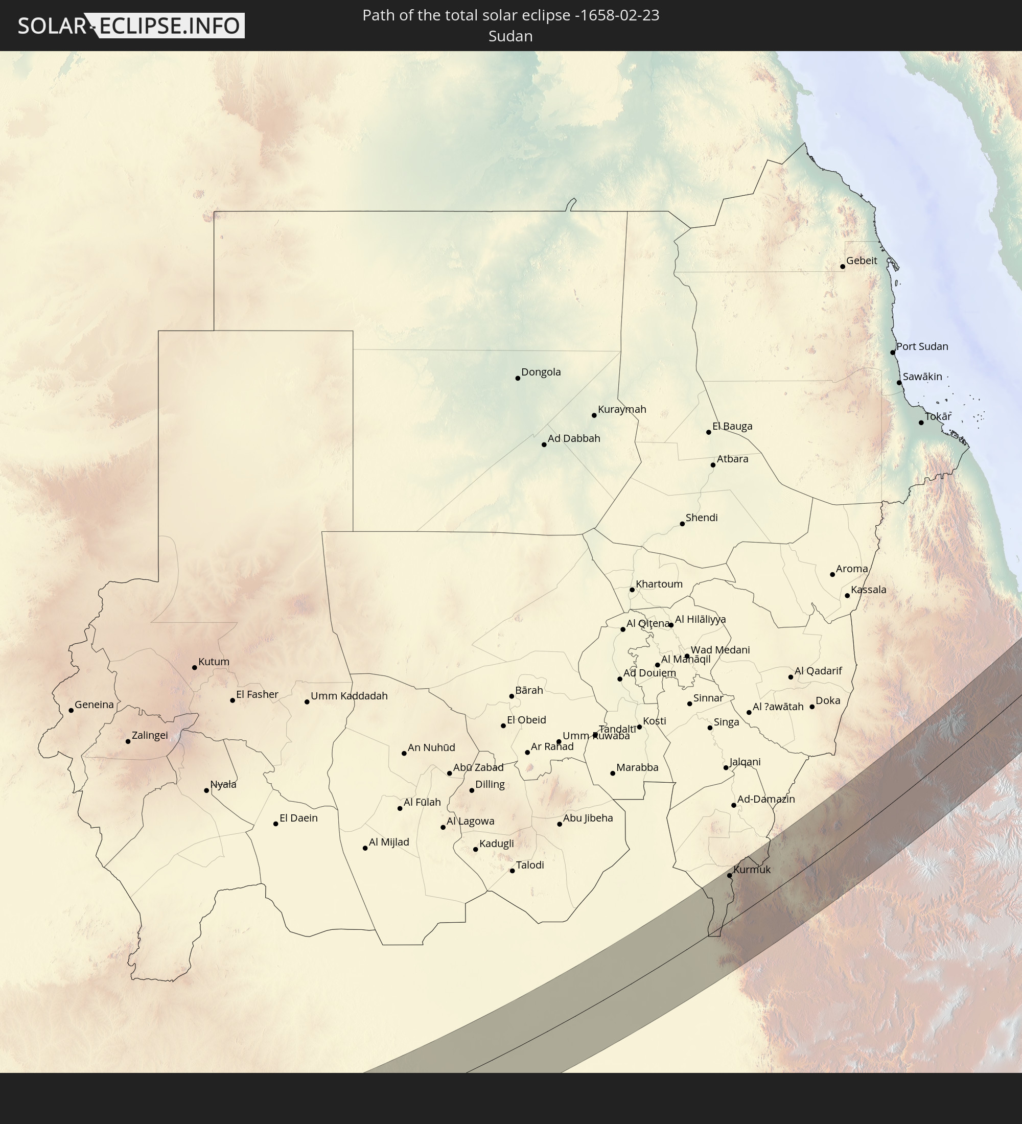 Sudan
Sudan
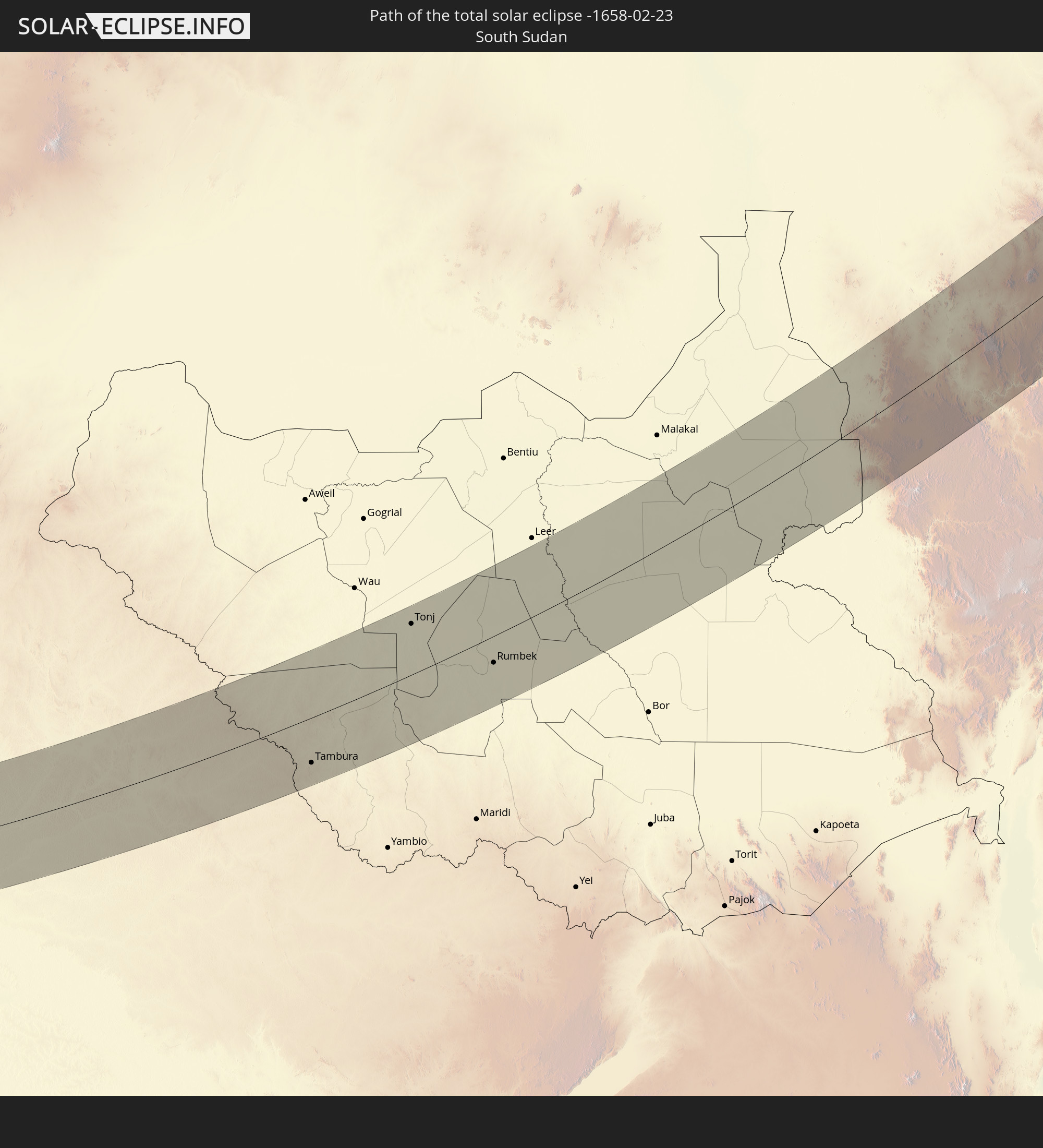 South Sudan
 Ethiopia
 Saudi Arabia
 Eritrea
 Yemen
Yemen
 Iran
Iran
 Kazakhstan
 Bahrain
 Qatar
Qatar
 United Arab Emirates
 Turkmenistan
 Uzbekistan
 Afghanistan
 Tajikistan
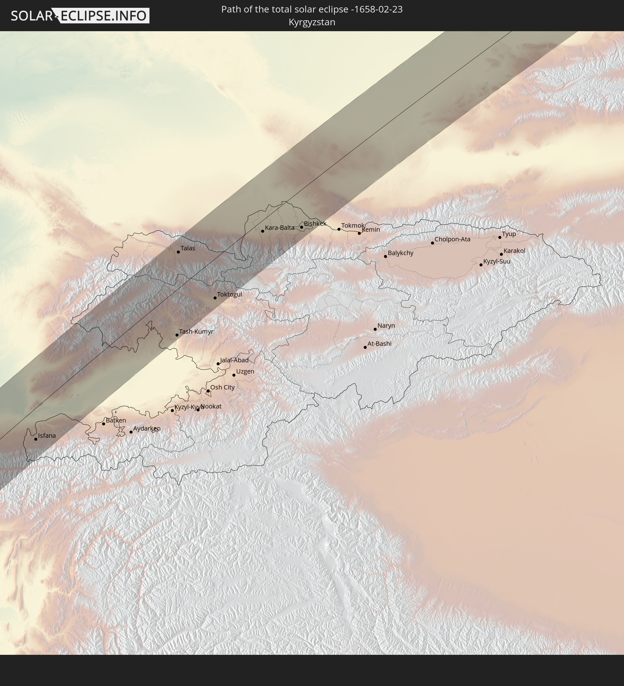 Kyrgyzstan
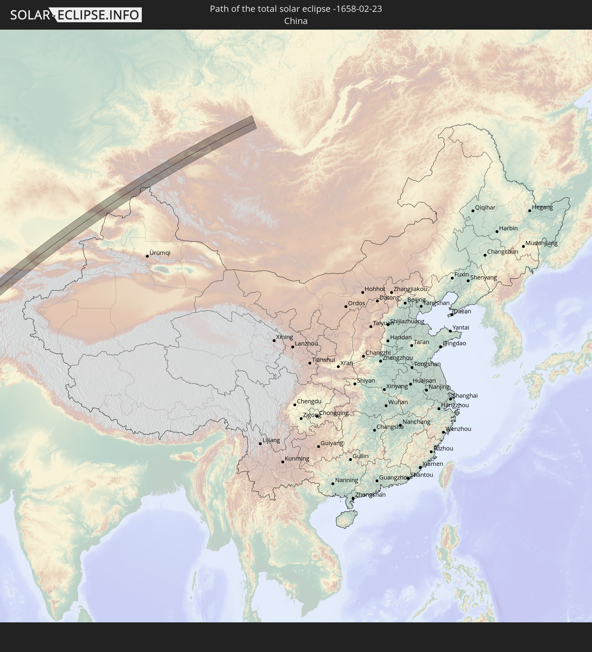 China
China
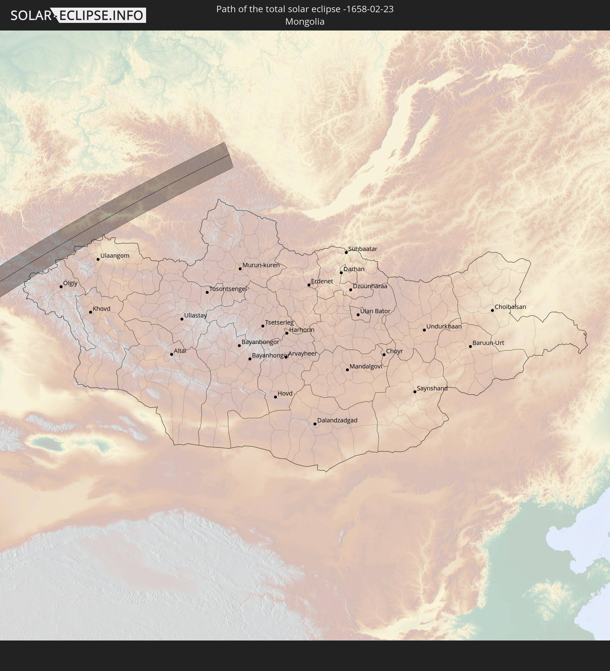 Mongolia
In den folgenden Ländern ist die Sonnenfinsternis partiell zu sehen
 Russia
 Portugal
 Spain
Spain
 Senegal
 Mauritania
 Guinea
 Saint Helena, Ascension and Tristan da Cunha
 Sierra Leone
 Morocco
 Mali
Mali
 Liberia
 Republic of Ireland
 Algeria
 United Kingdom
 Ivory Coast
 Faroe Islands
 Burkina Faso
 Gibraltar
 France
 Isle of Man
 Ghana
Ghana
 Guernsey
 Jersey
 Togo
Togo
 Niger
Niger
 Benin
Benin
 Andorra
 Belgium
 Nigeria
 Netherlands
 Norway
 Equatorial Guinea
 Luxembourg
 Germany
 Switzerland
 São Tomé and Príncipe
 Italy
Italy
 Monaco
 Tunisia
 Denmark
 Cameroon
 Gabon
Gabon
 Libya
Libya
 Liechtenstein
 Austria
 Sweden
 Republic of the Congo
 Angola
 Namibia
 Czechia
 Democratic Republic of the Congo
 San Marino
 Vatican City
 Slovenia
 Chad
Chad
 Croatia
 Poland
 Malta
Malta
 Central African Republic
 Bosnia and Herzegovina
 Hungary
 South Africa
 Slovakia
 Montenegro
 Serbia
 Albania
 Åland Islands
 Greece
 Botswana
 Romania
 Republic of Macedonia
 Finland
 Lithuania
 Latvia
 Estonia
 Sudan
Sudan
 Zambia
 Ukraine
 Bulgaria
 Belarus
 Egypt
Egypt
 Zimbabwe
 Turkey
 Moldova
 Rwanda
 Burundi
 Tanzania
 Uganda
 Mozambique
 Swaziland
 Cyprus
 Malawi
 Ethiopia
 Kenya
Kenya
 State of Palestine
 Israel
 Saudi Arabia
 Jordan
 Lebanon
 Syria
Syria
 Eritrea
 Iraq
Iraq
 Georgia
 French Southern and Antarctic Lands
 Somalia
 Djibouti
 Yemen
Yemen
 Madagascar
 Comoros
 Armenia
 Iran
Iran
 Azerbaijan
 Mayotte
 Seychelles
 Kazakhstan
 Kuwait
 Bahrain
 Qatar
Qatar
 United Arab Emirates
 Oman
Oman
 Turkmenistan
 Uzbekistan
 Mauritius
 Afghanistan
 Pakistan
 Tajikistan
 India
India
 Kyrgyzstan
 Maldives
 China
China
 Sri Lanka
 Nepal
Nepal
 Mongolia
 Bangladesh
 Bhutan
 Myanmar
 Thailand
 Laos
Laos
 Vietnam
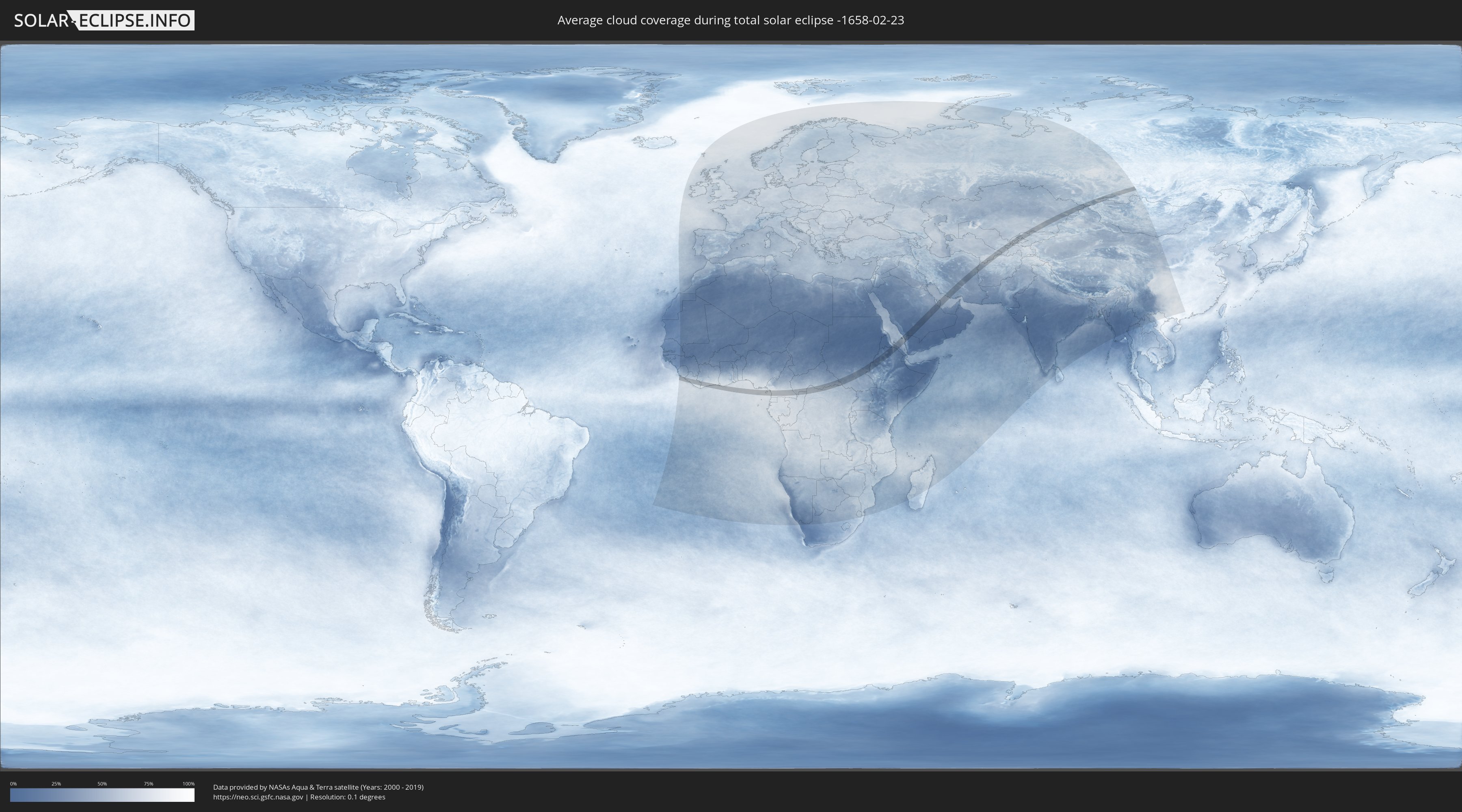
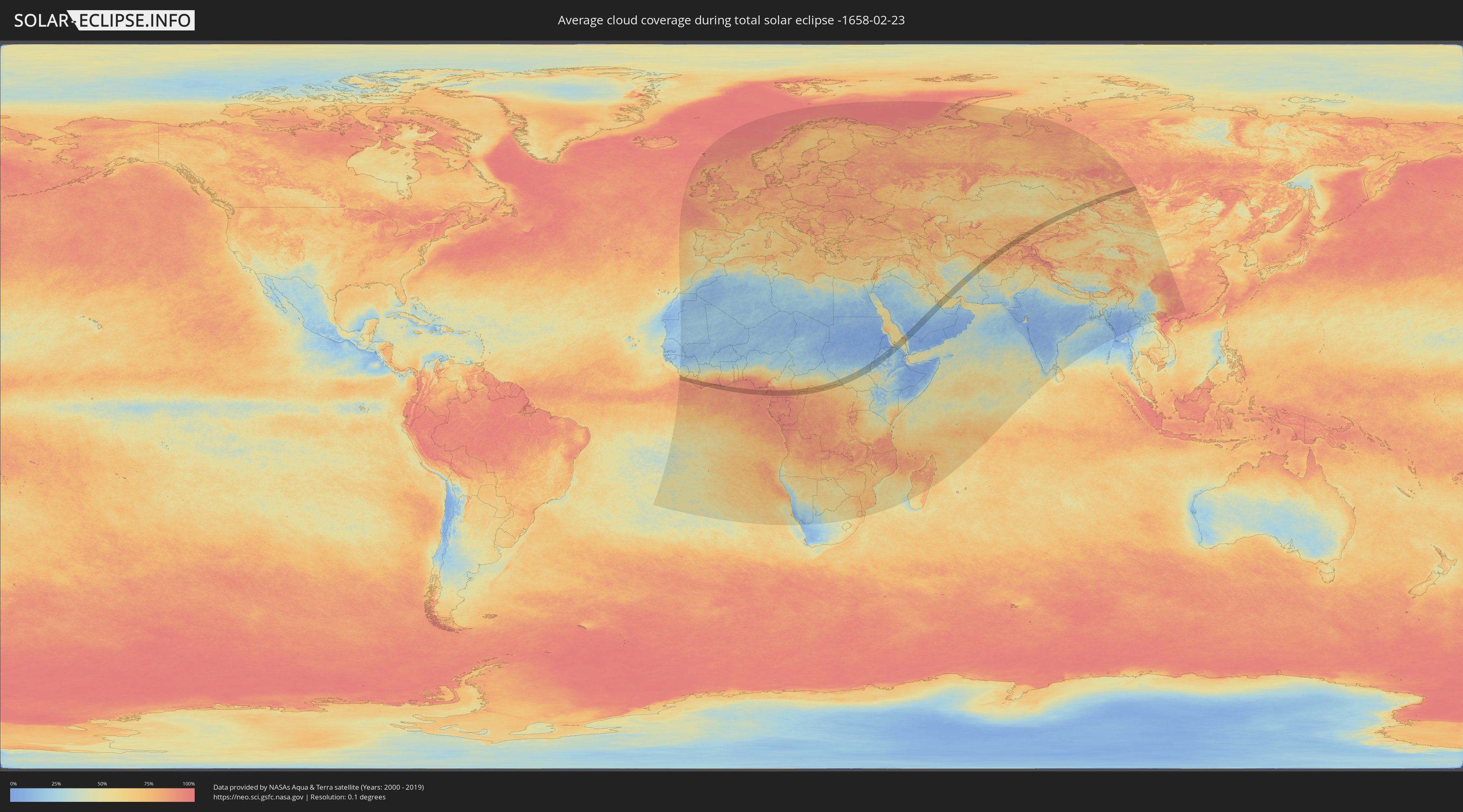
How will be the weather during the total solar eclipse on 02/23/-1658?
Where is the best place to see the total solar eclipse of 02/23/-1658?
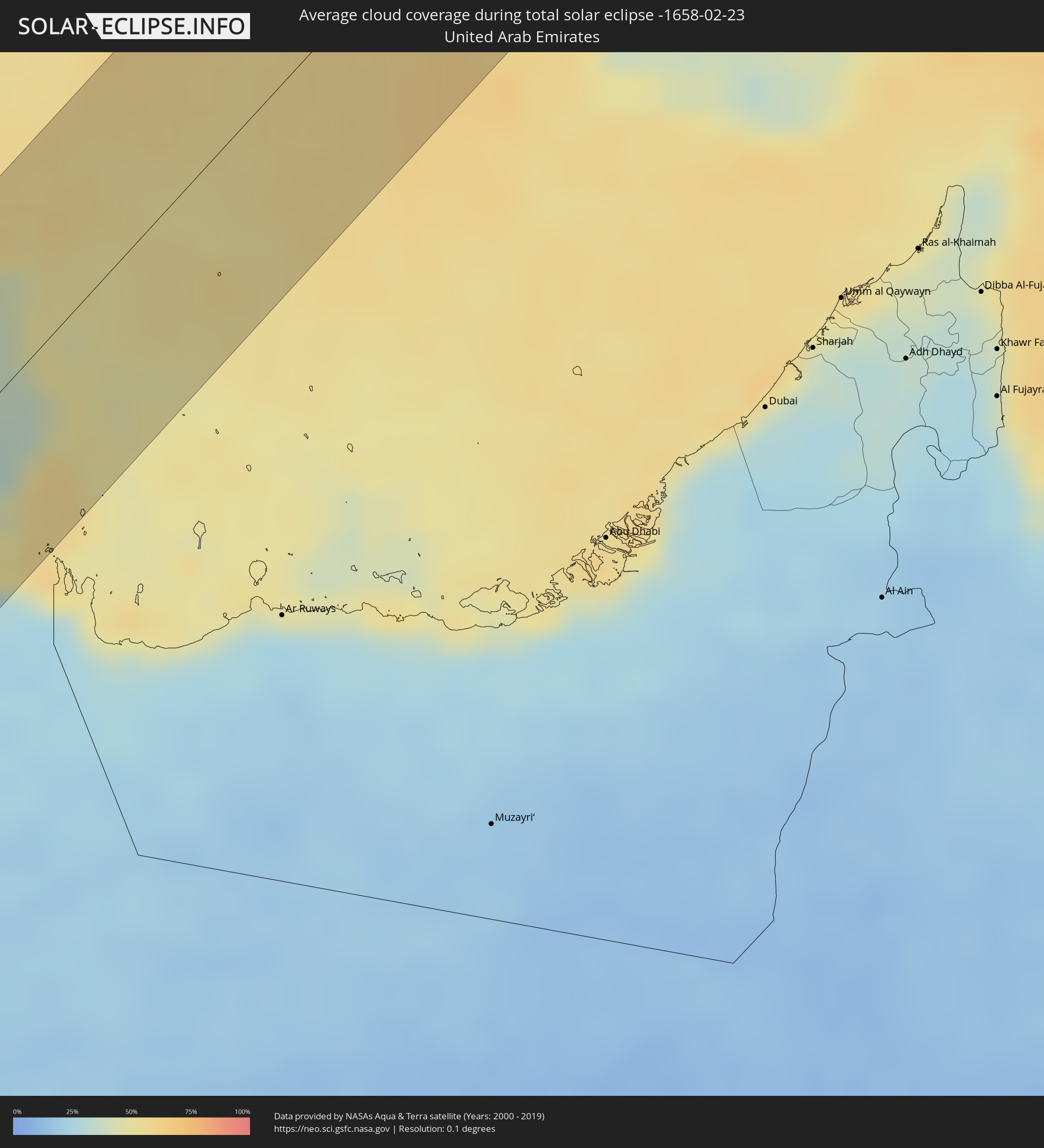
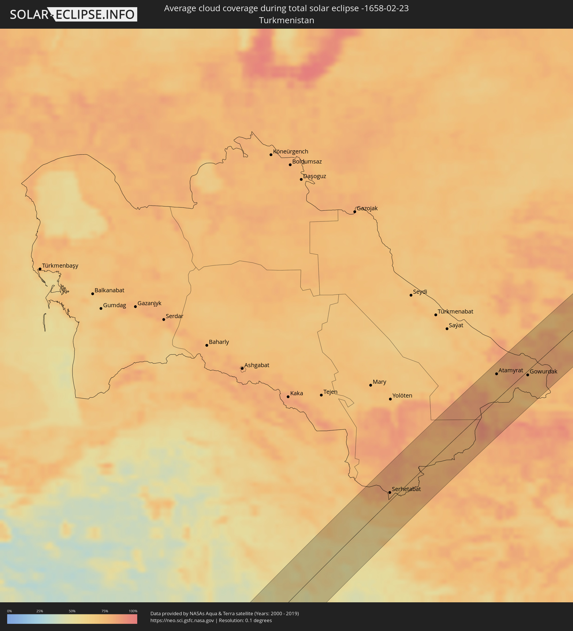
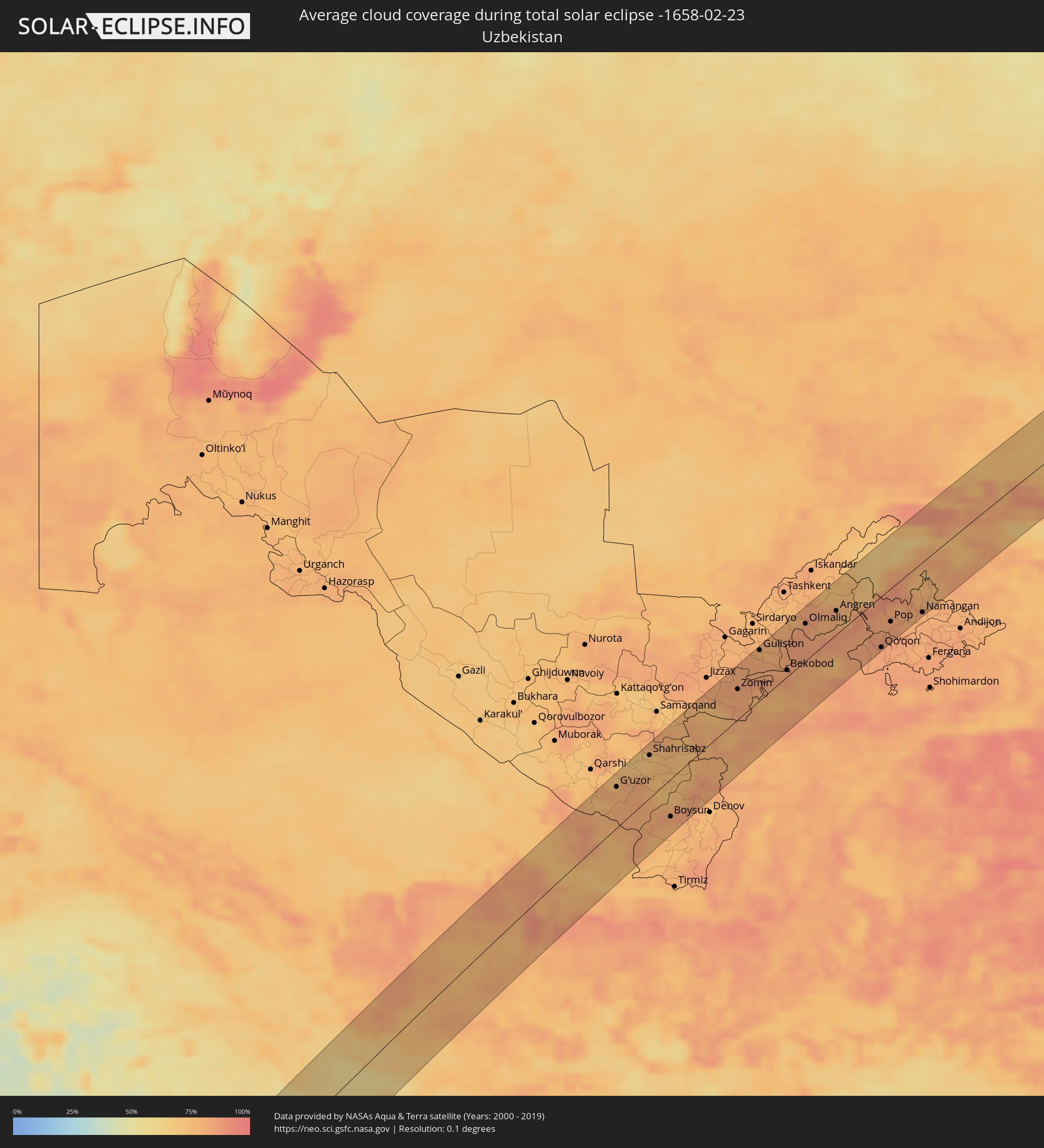
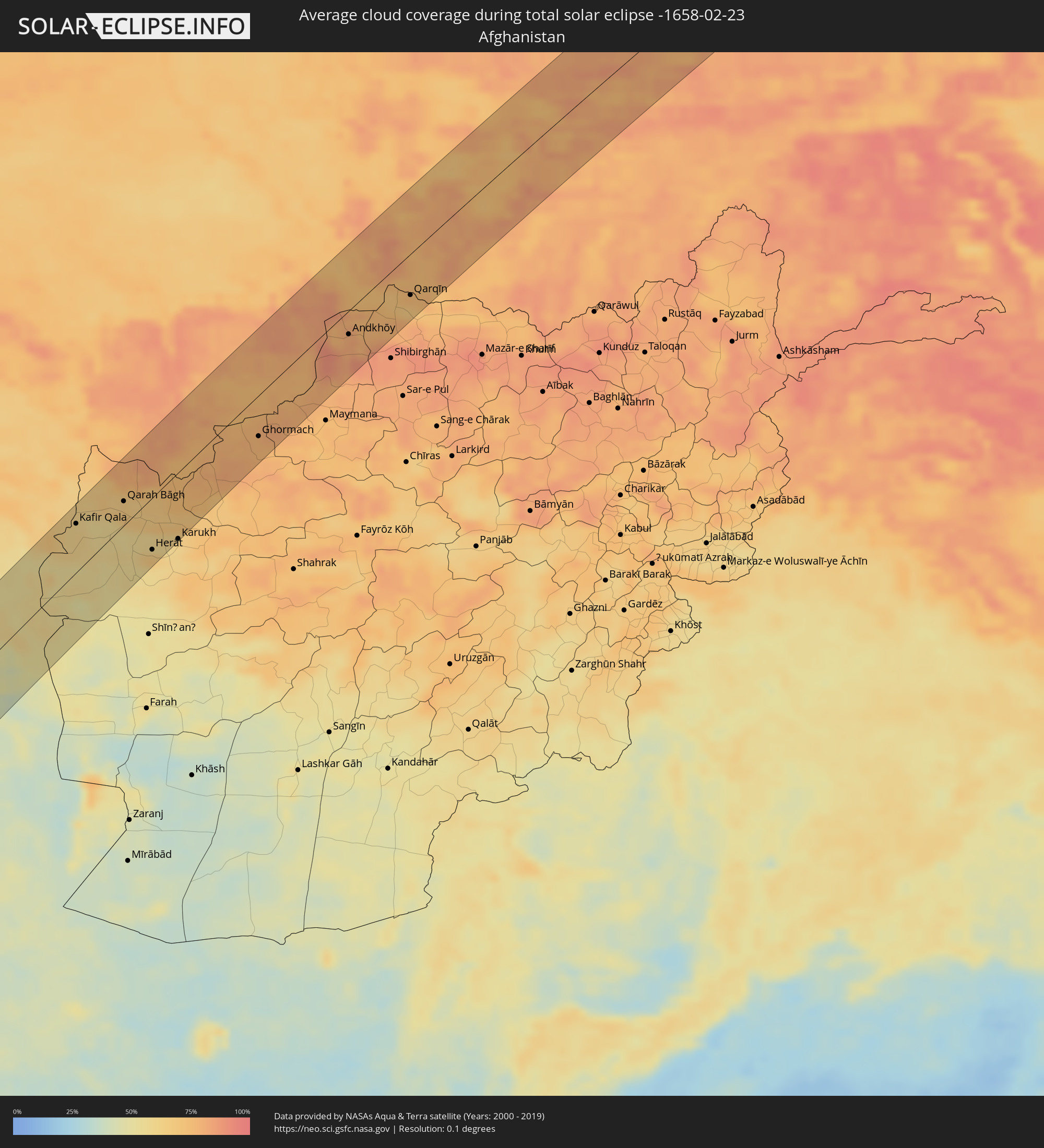
The following maps show the average cloud coverage for the day of the total solar eclipse.
With the help of these maps, it is possible to find the place along the eclipse path, which has the best
chance of a cloudless sky.
Nevertheless, you should consider local circumstances and inform about the weather of your chosen
observation site.
The data is provided by NASAs satellites
AQUA and TERRA.
The cloud maps are averaged over a period of 19 years (2000 - 2019).
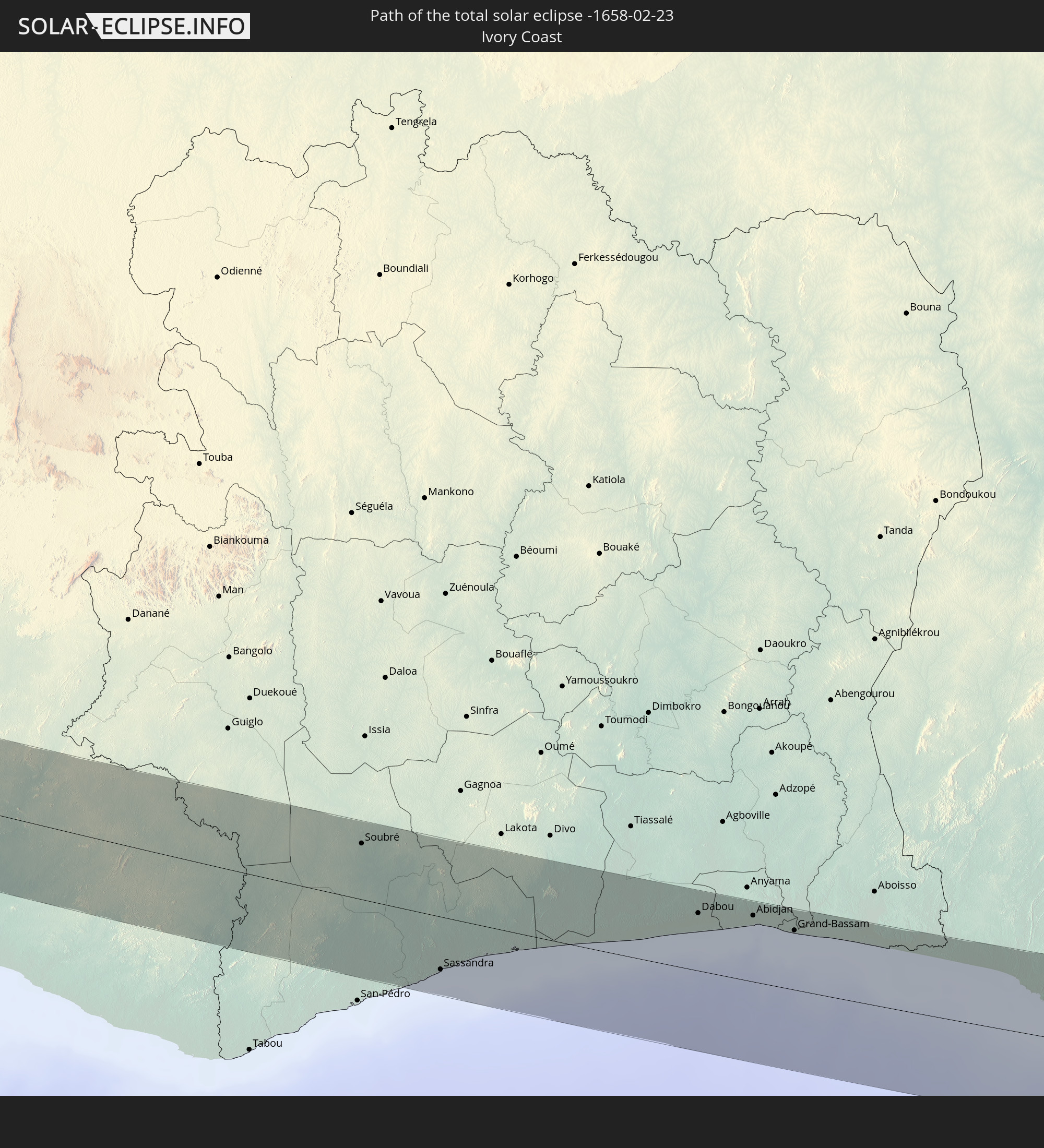
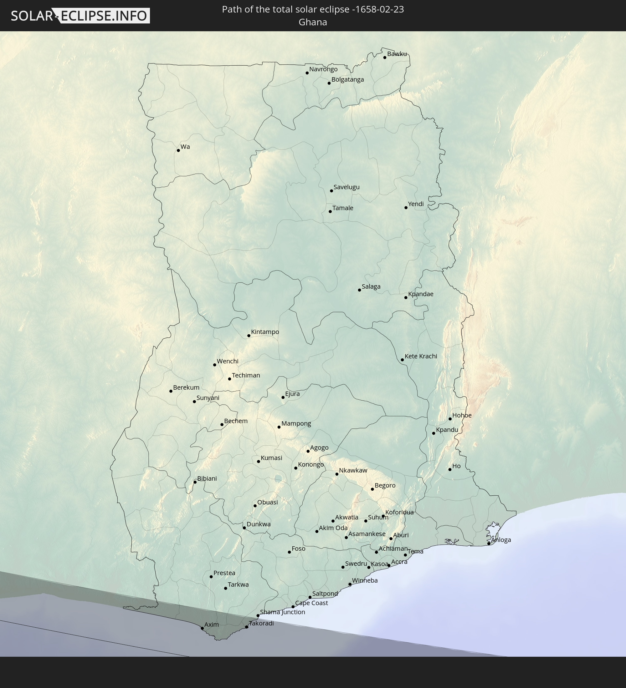
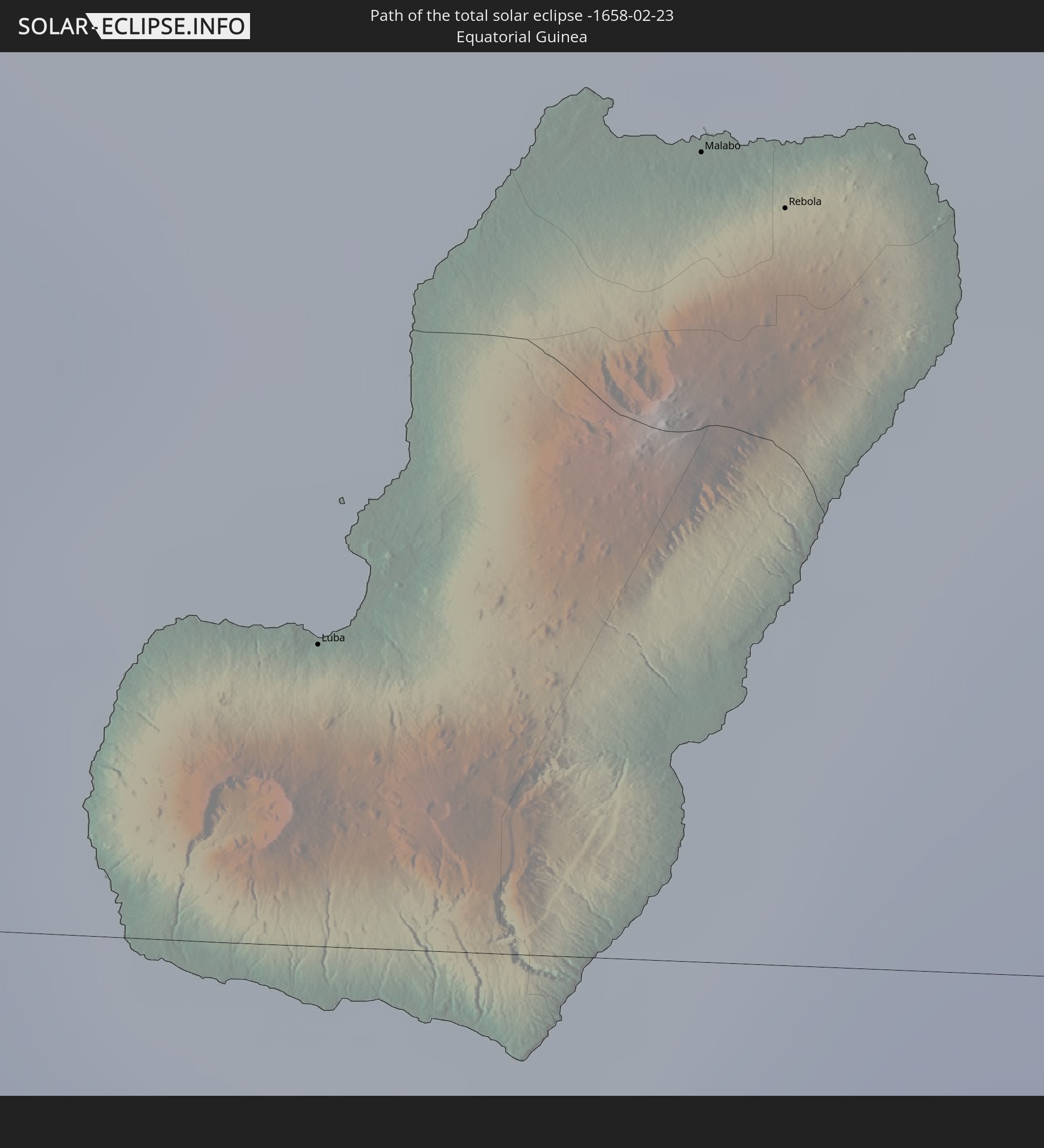
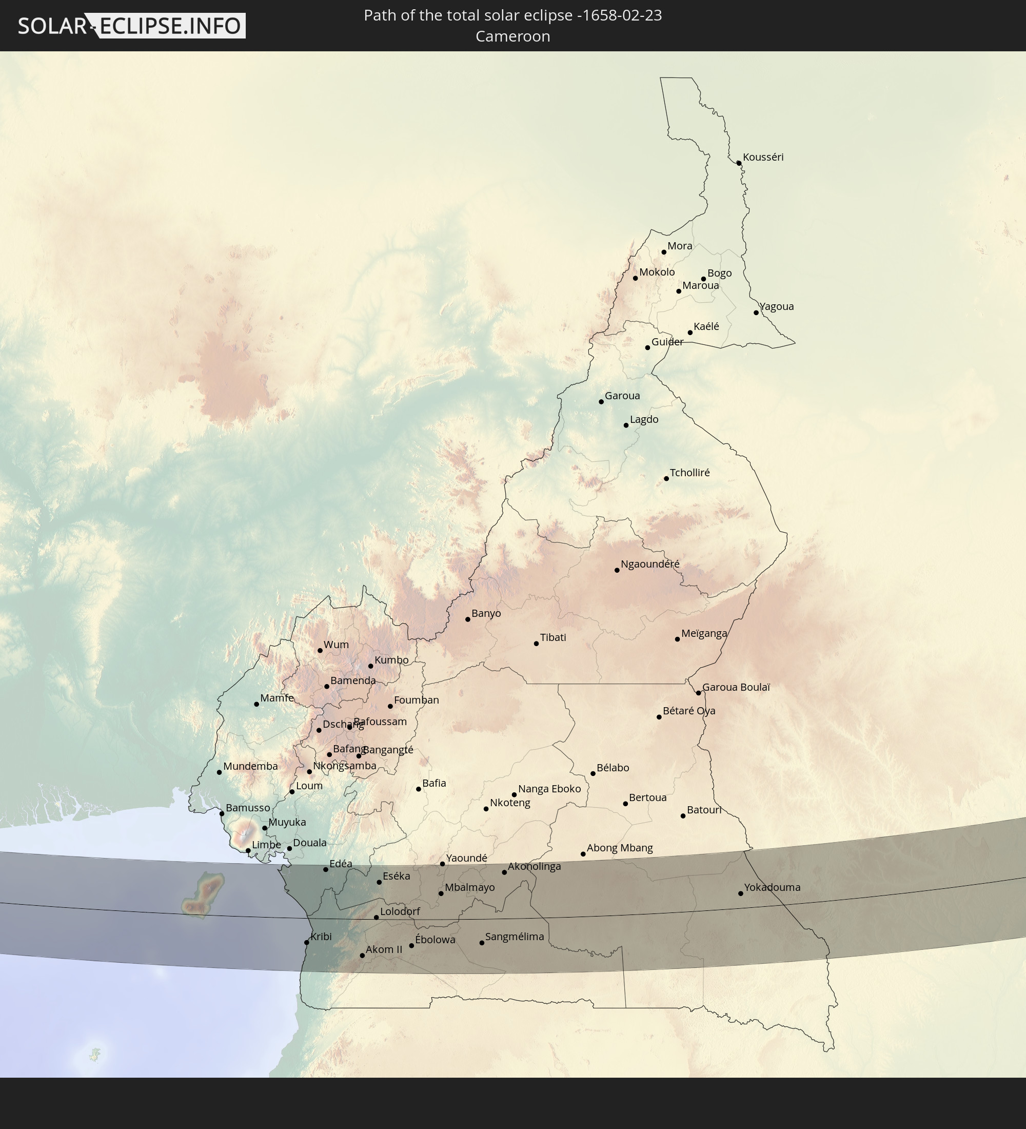
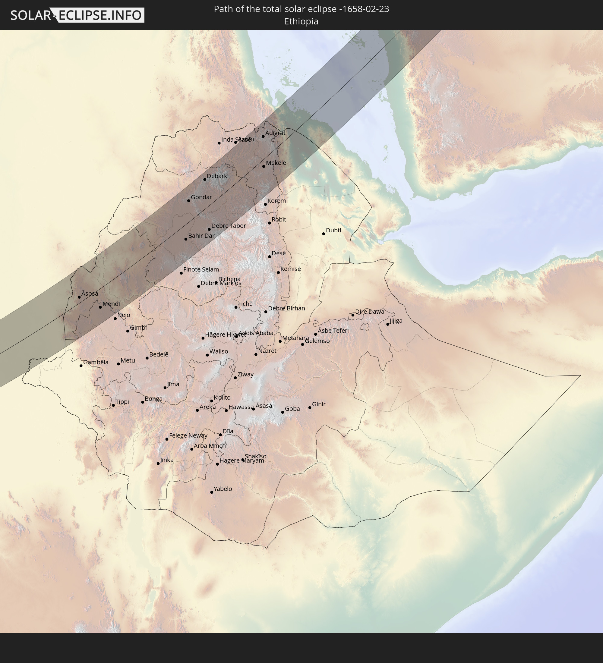
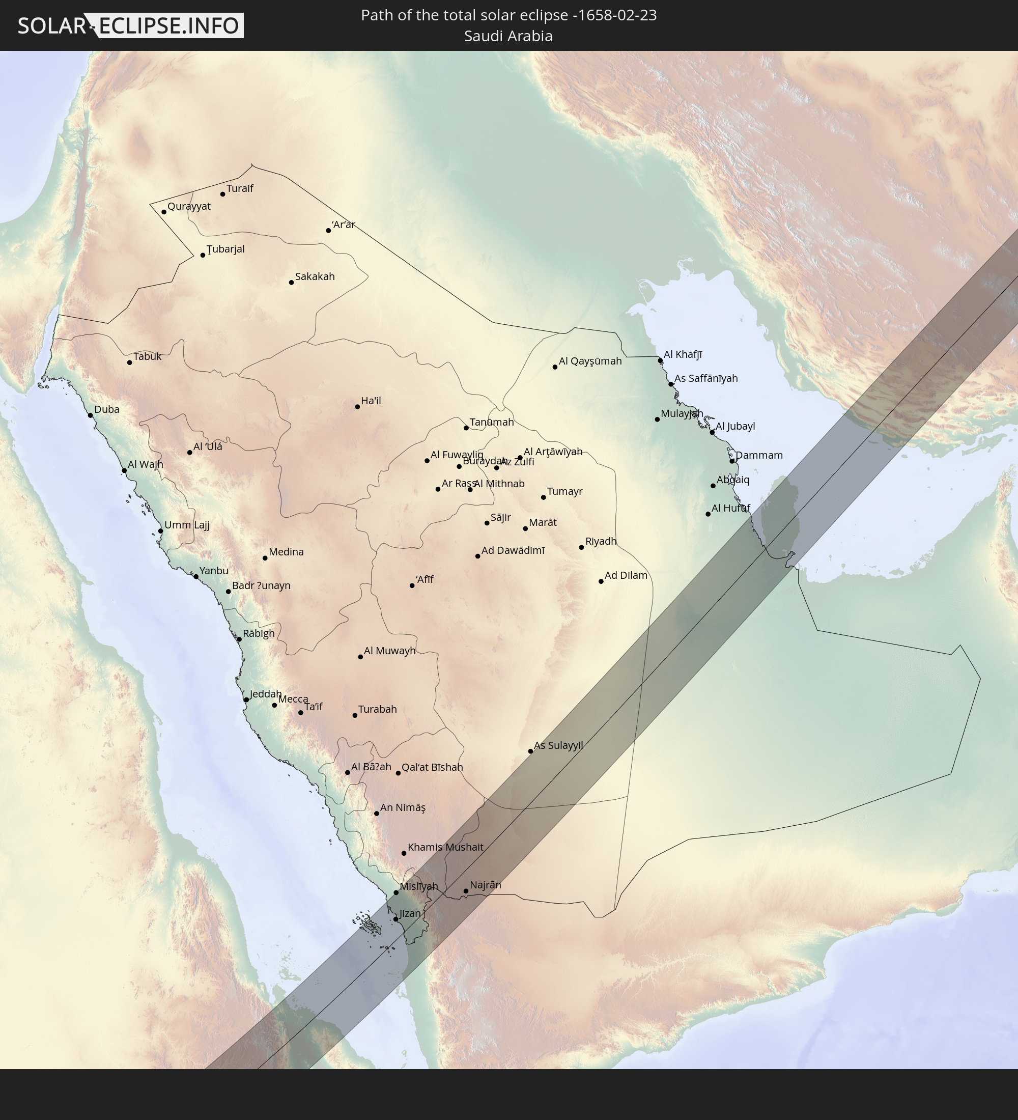
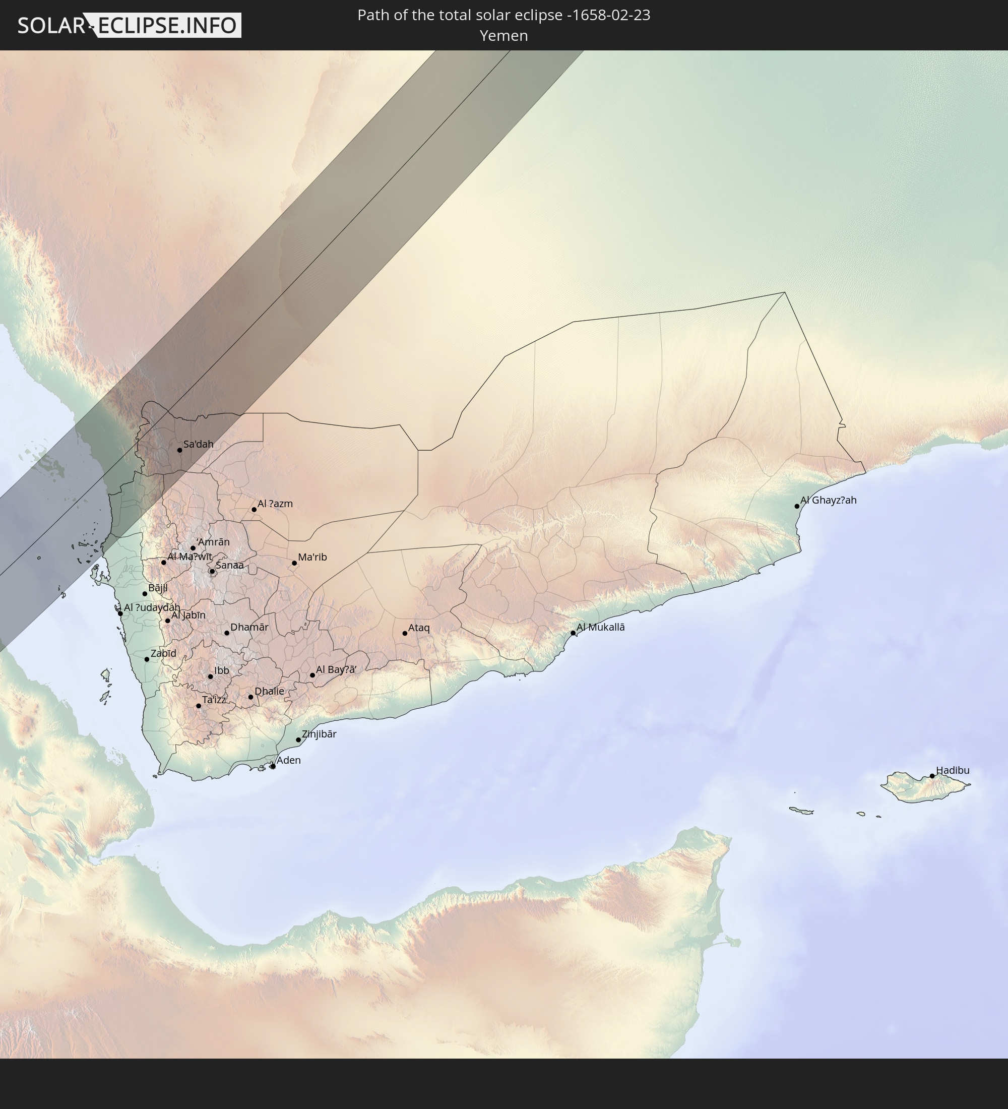
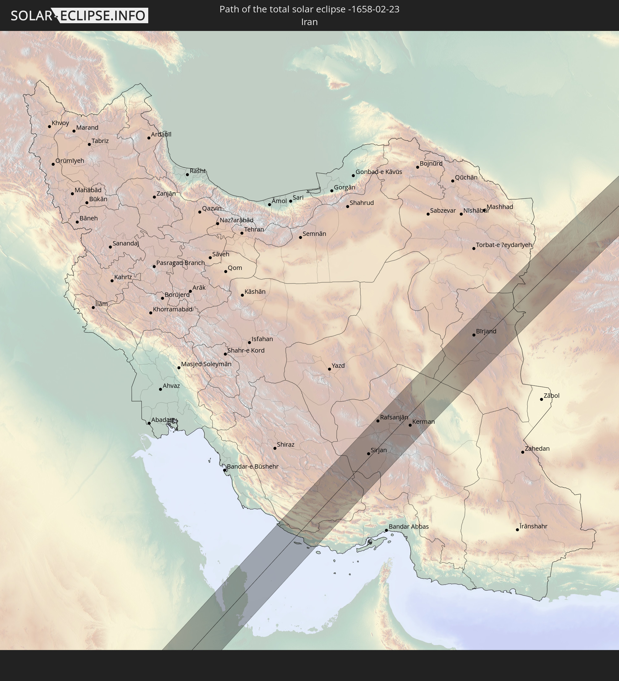
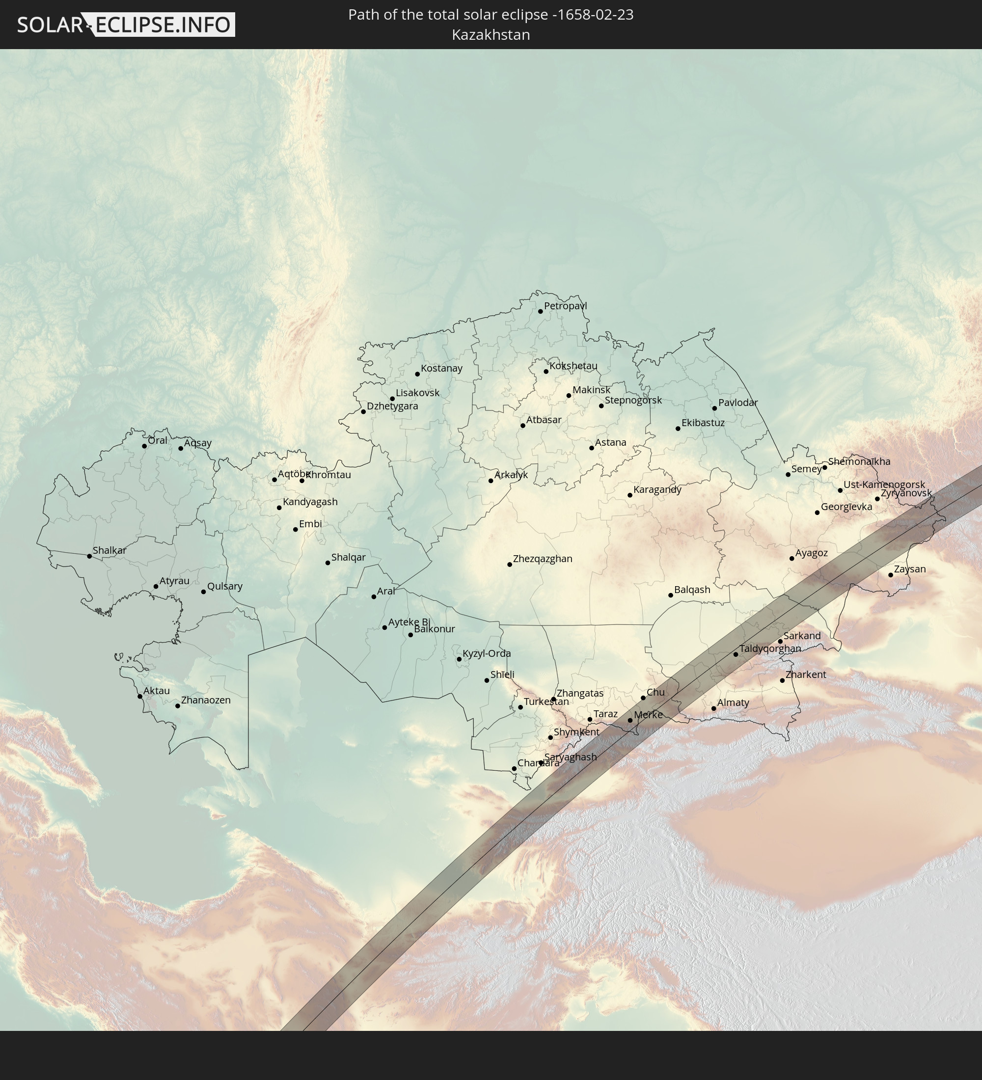
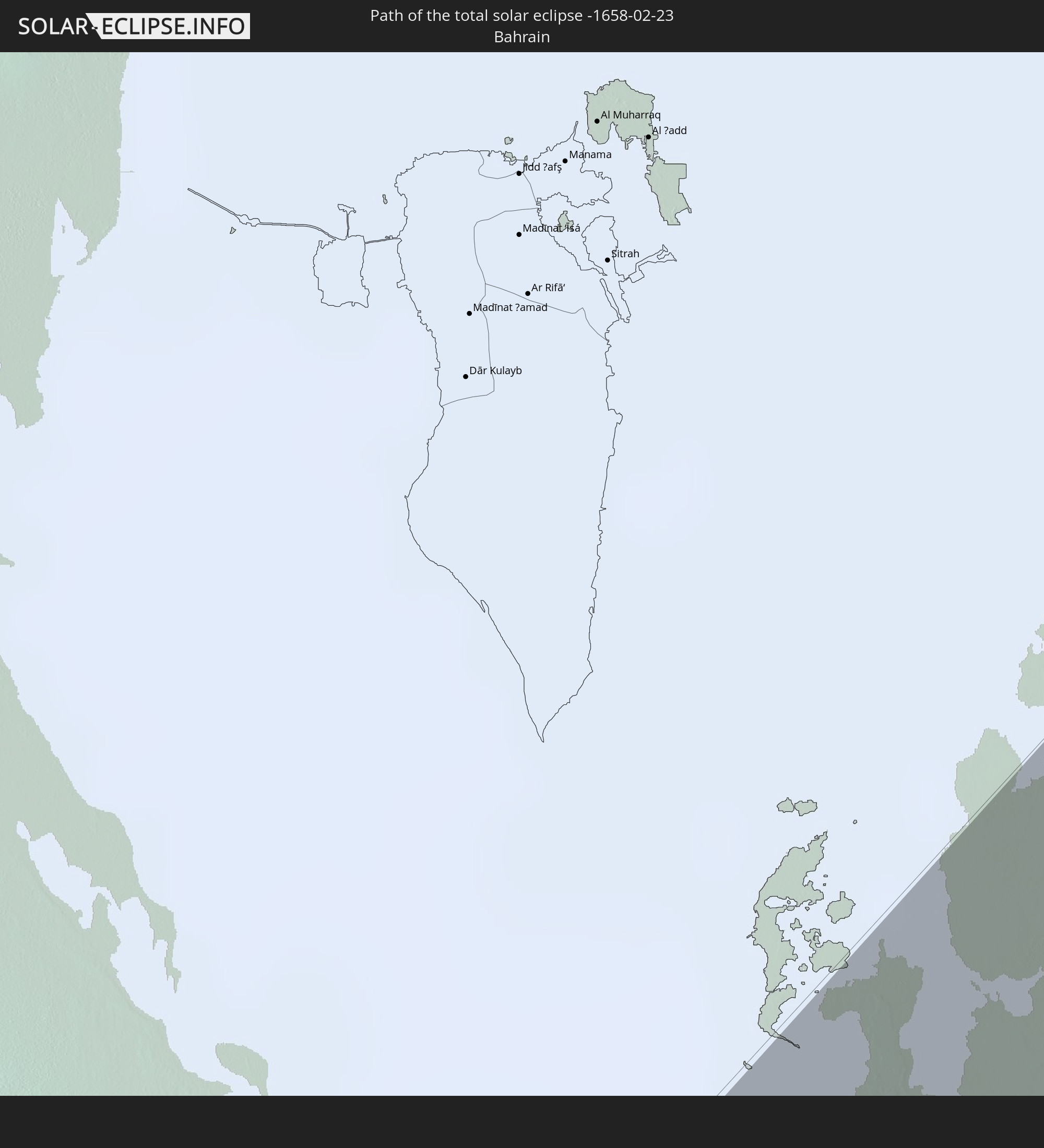
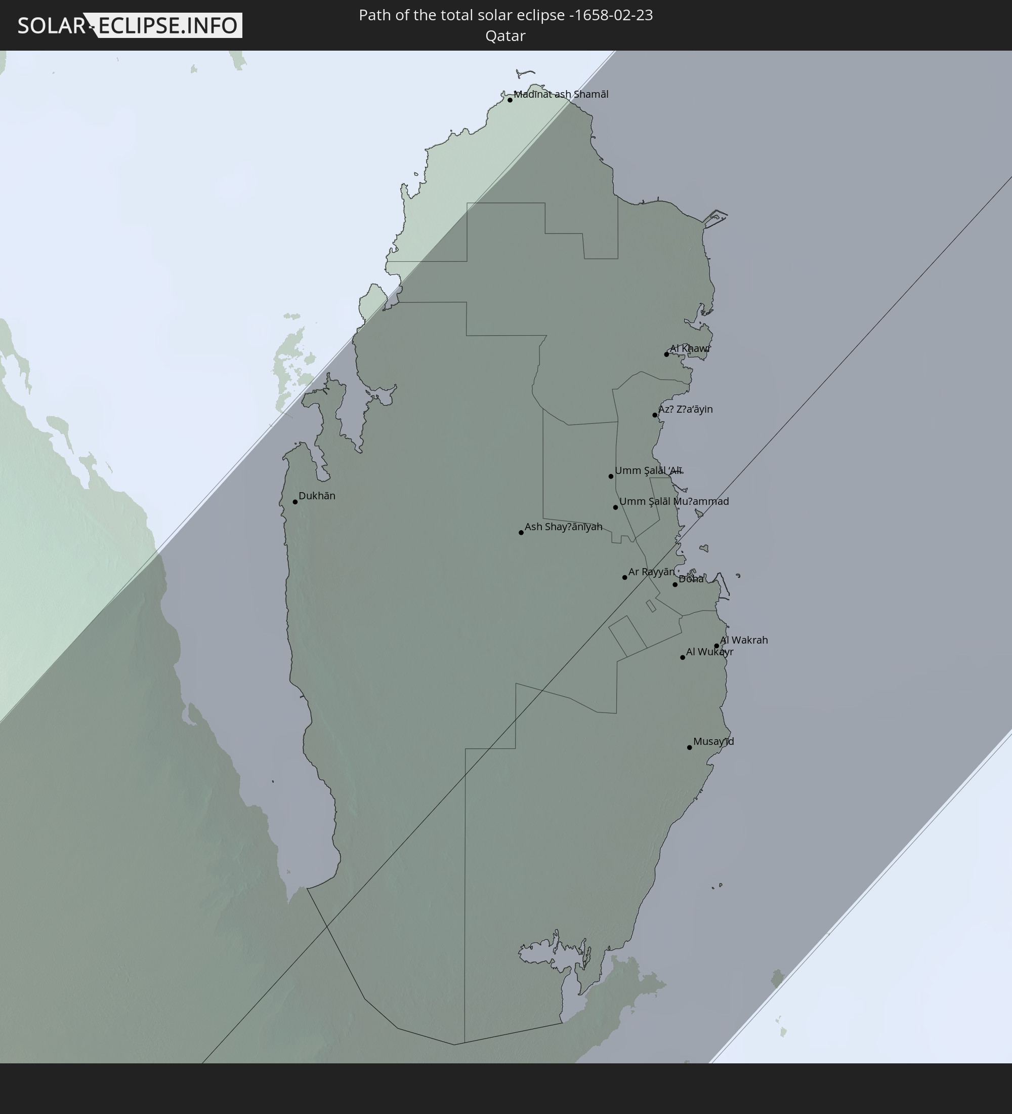
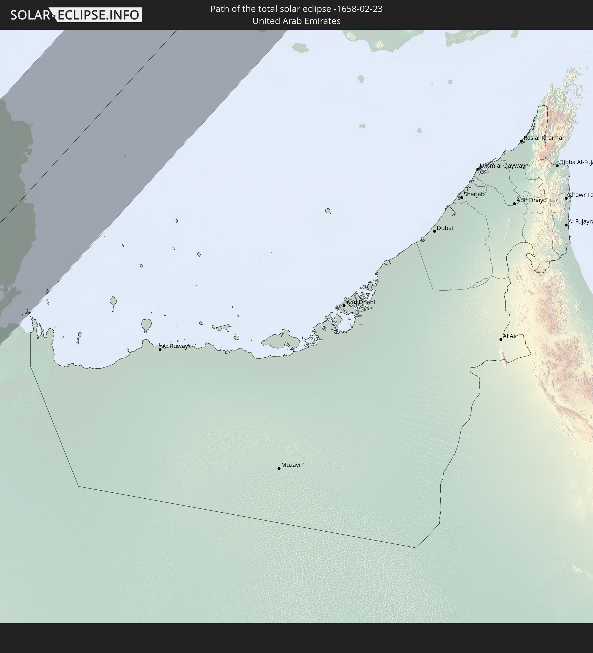
Detailed country maps
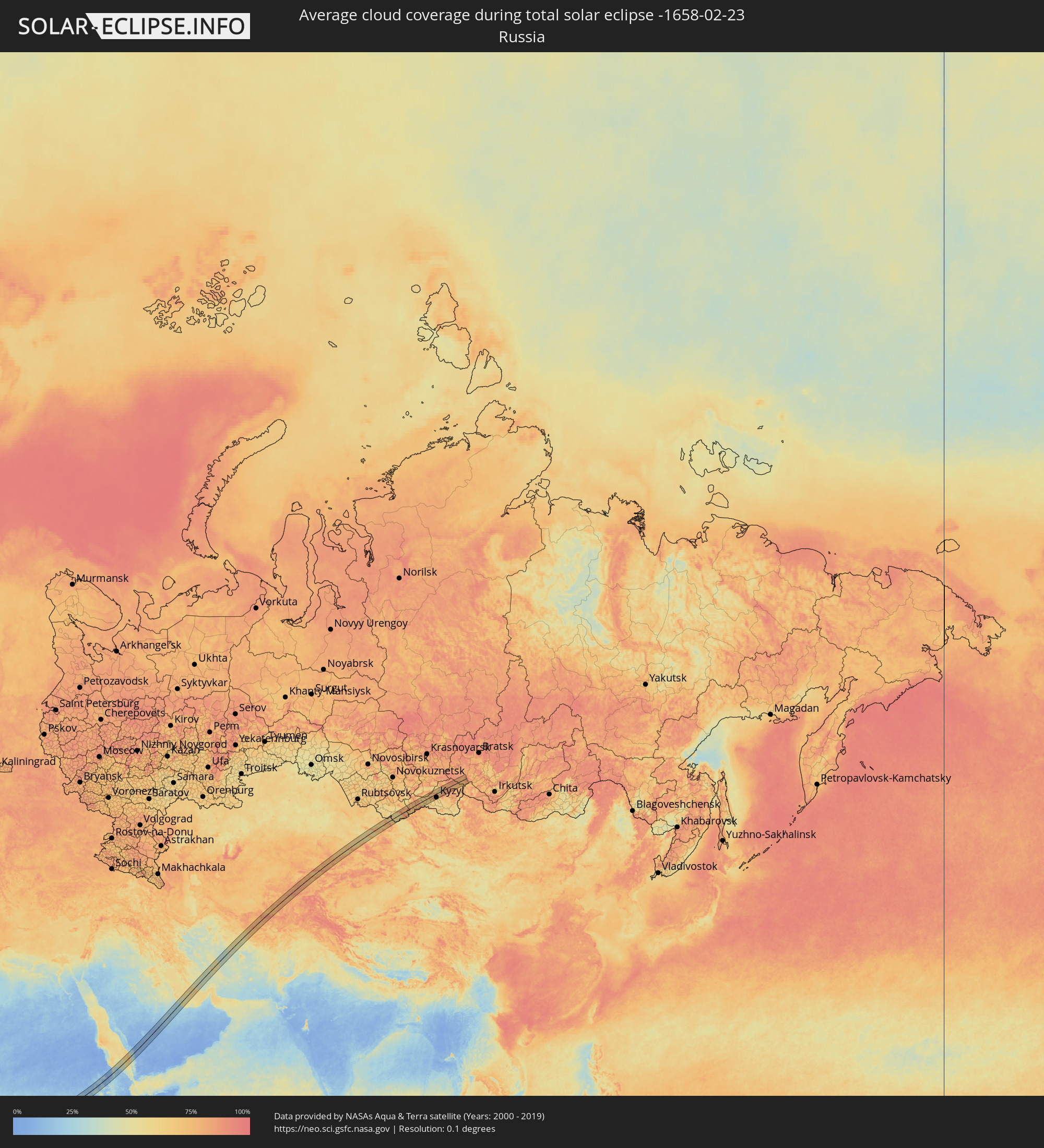 Russia
 Sierra Leone
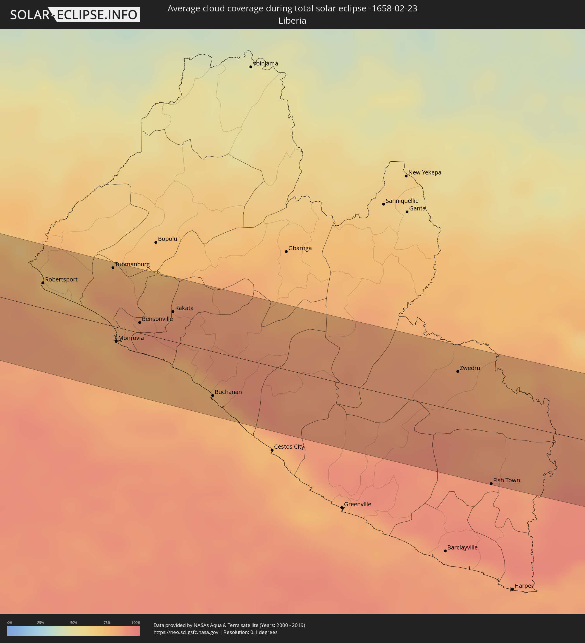 Liberia
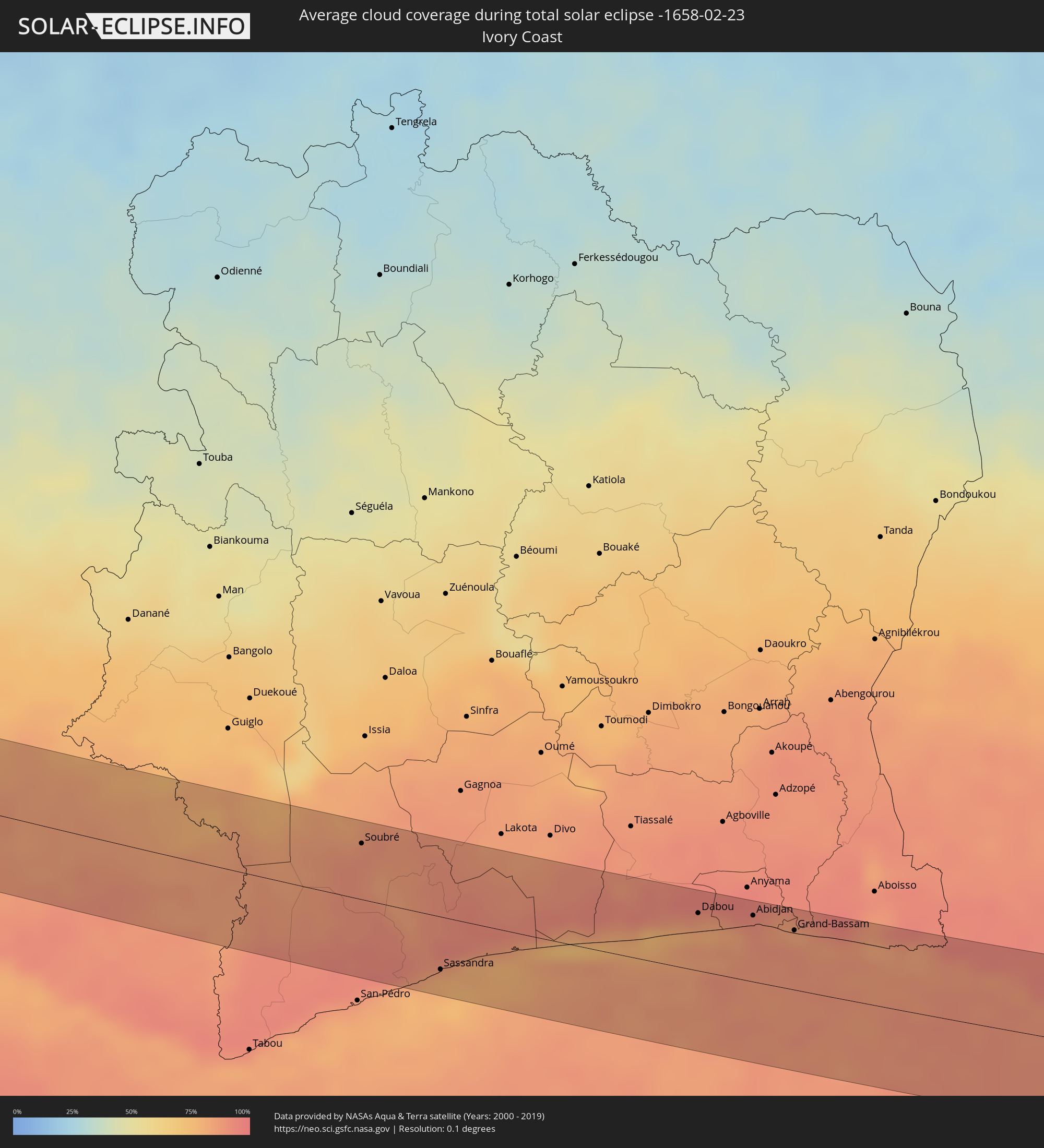 Ivory Coast
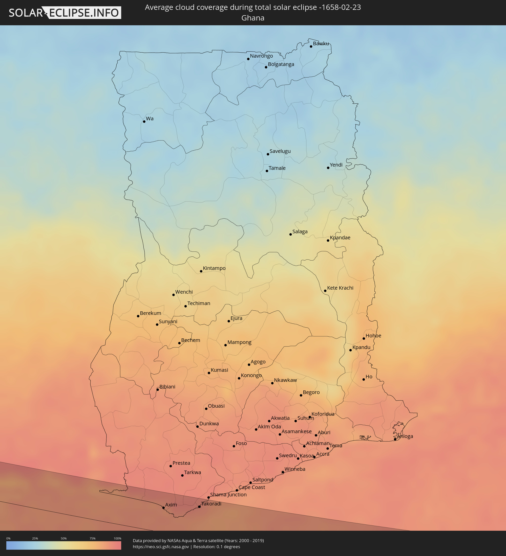 Ghana
Ghana
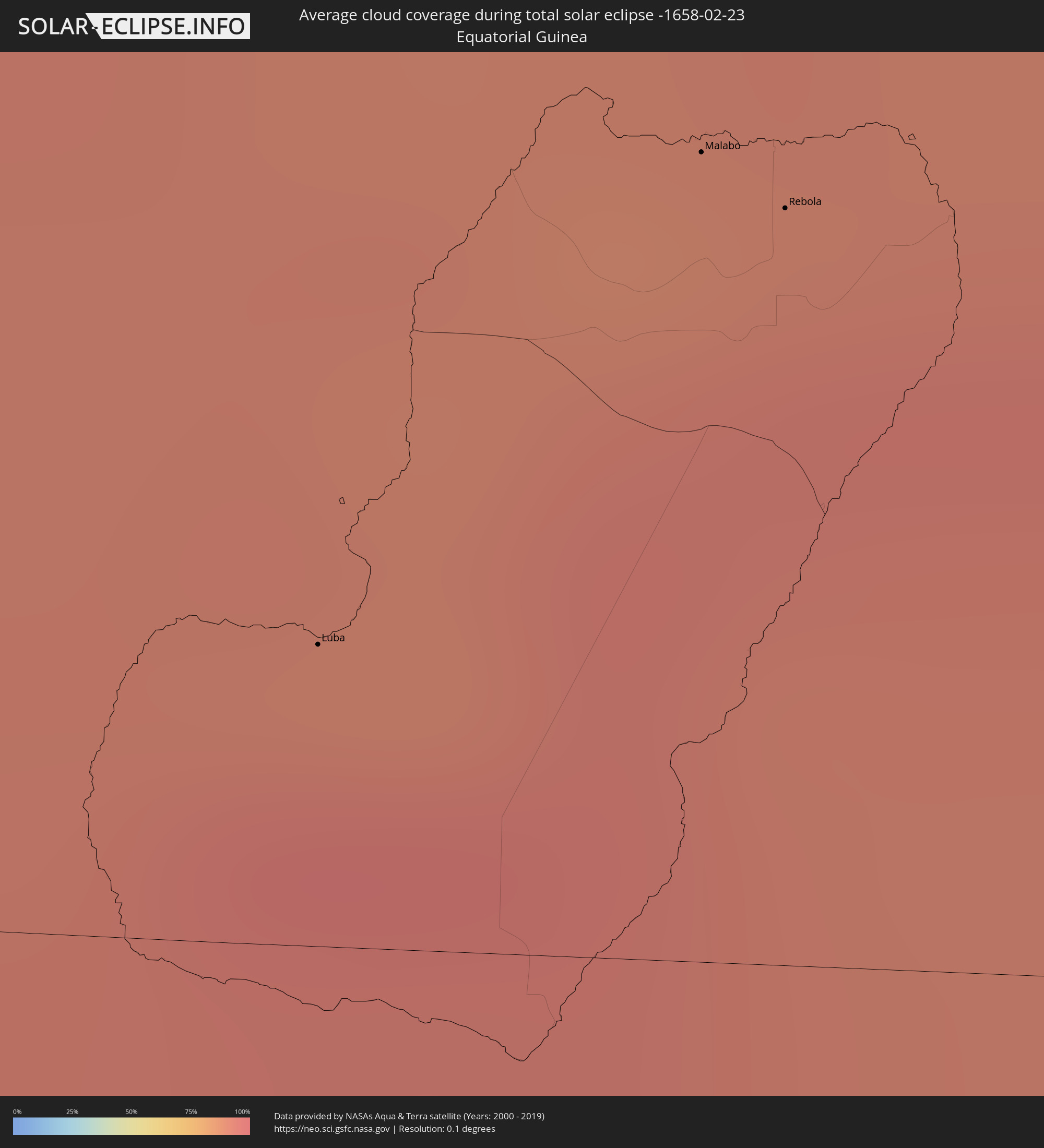 Equatorial Guinea
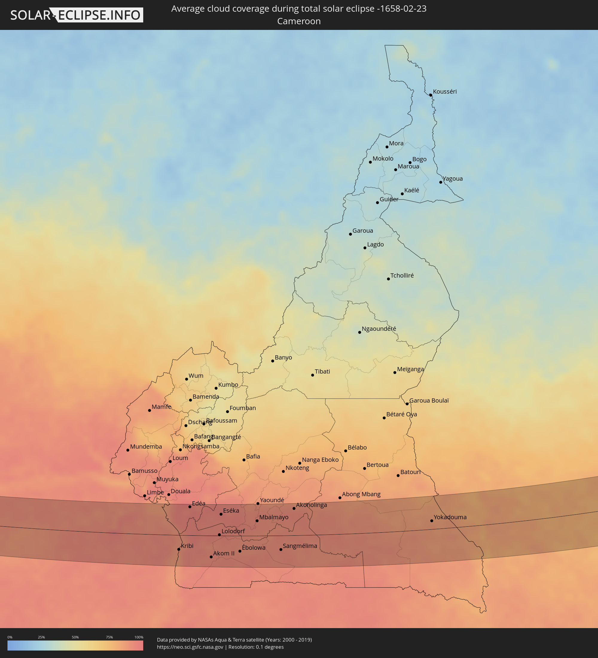 Cameroon
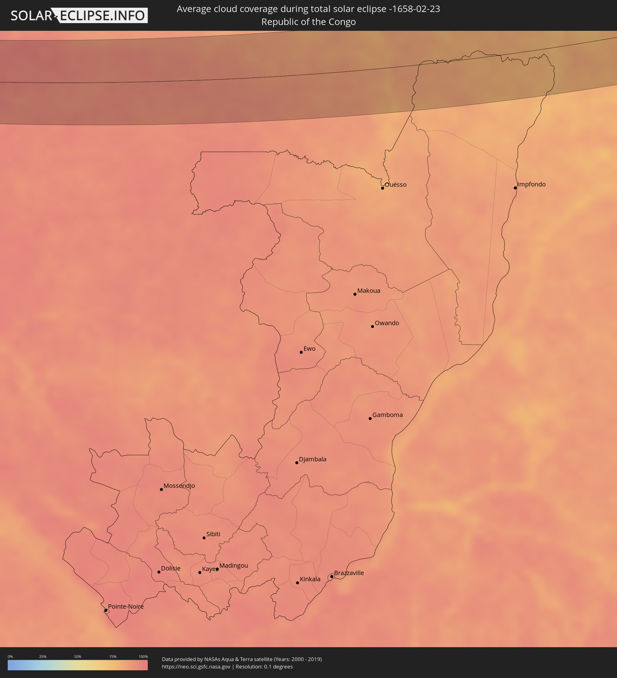 Republic of the Congo
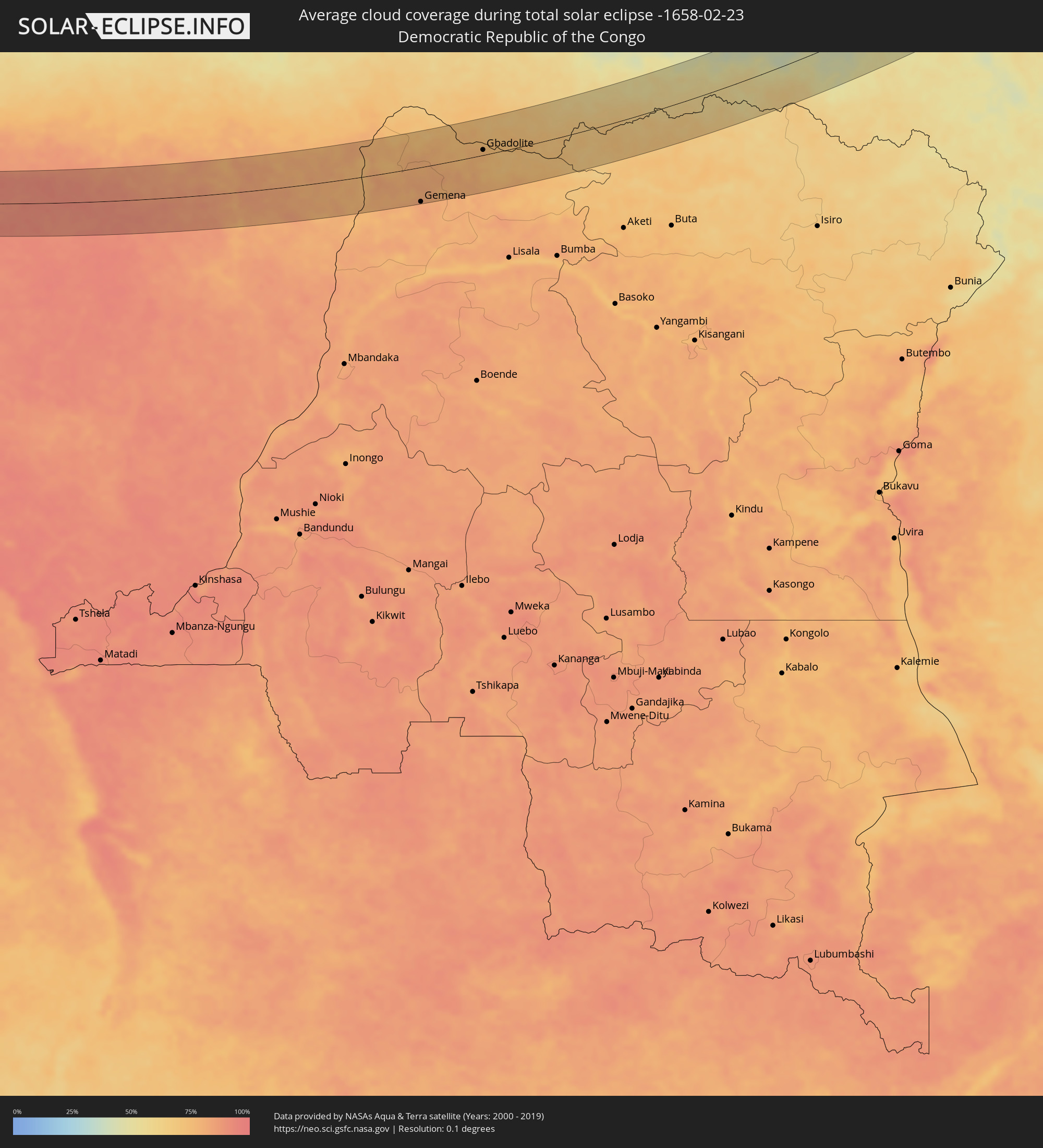 Democratic Republic of the Congo
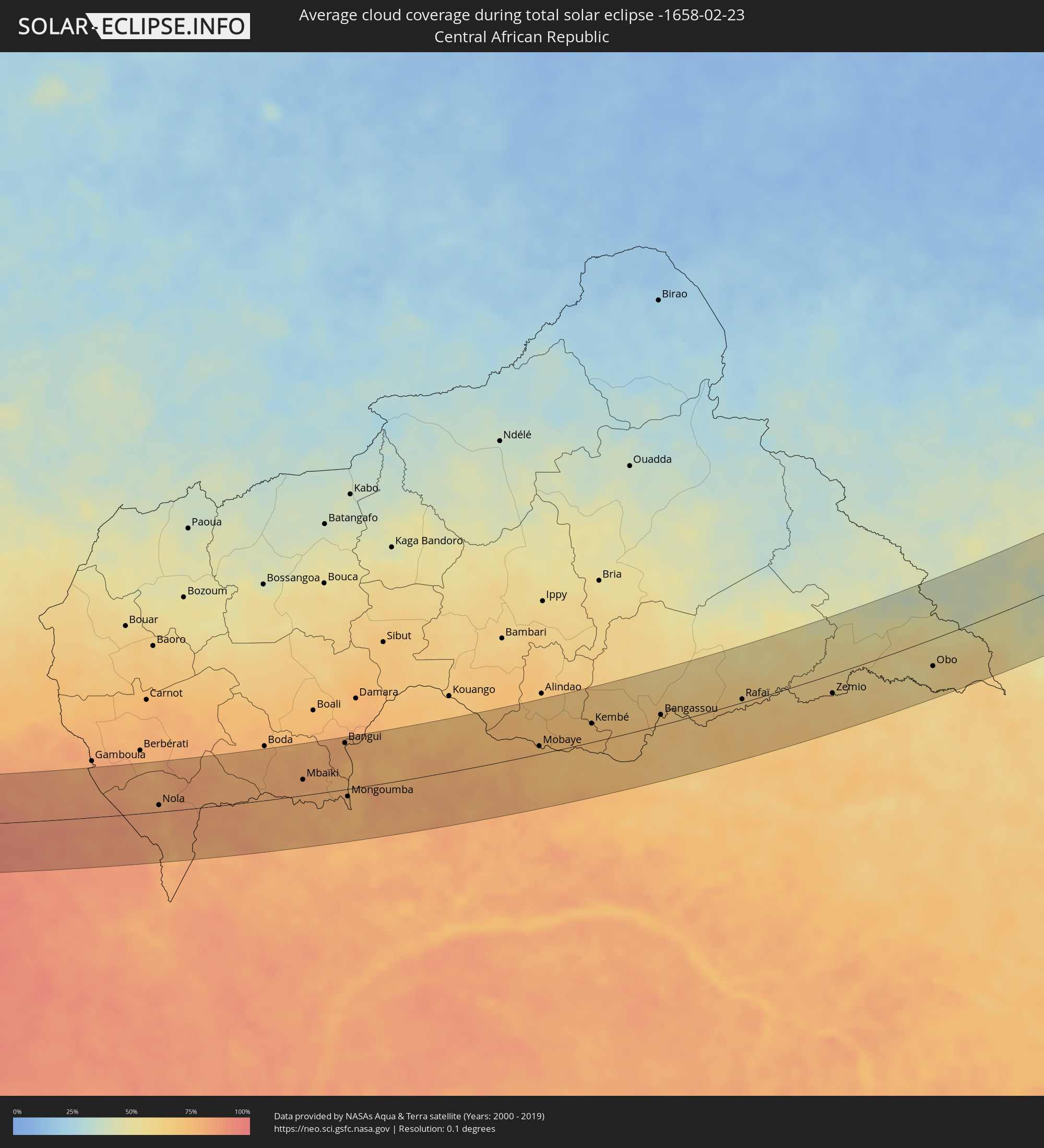 Central African Republic
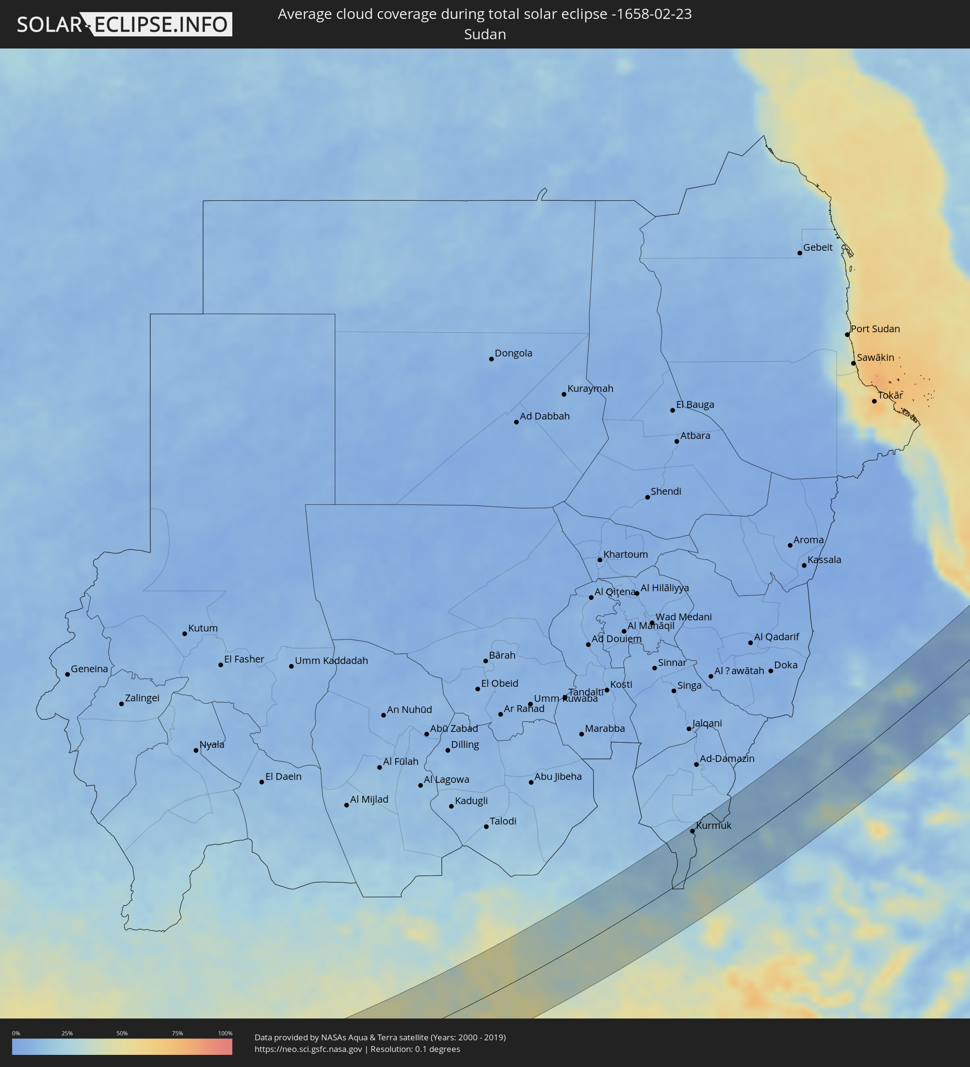 Sudan
Sudan
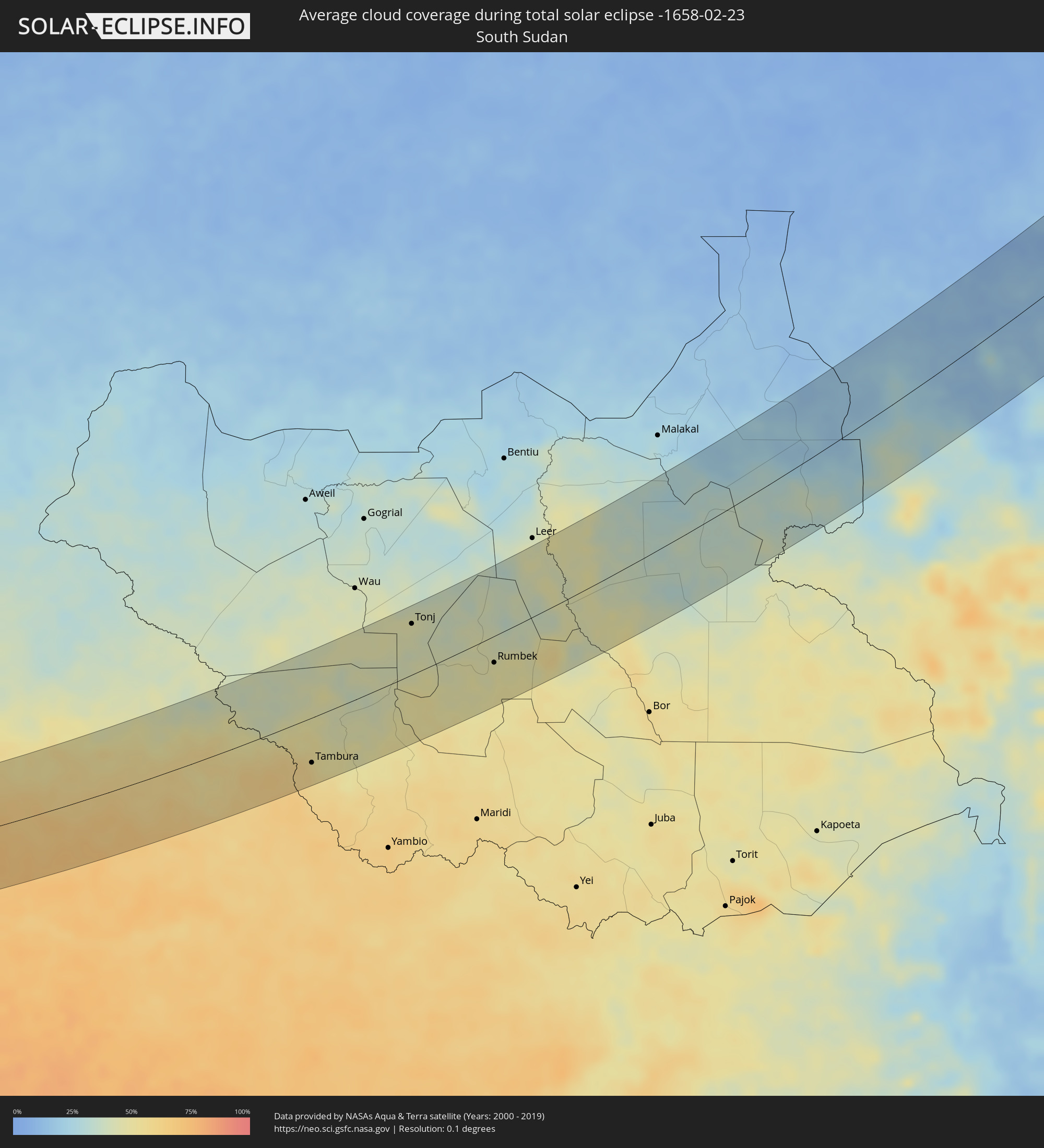 South Sudan
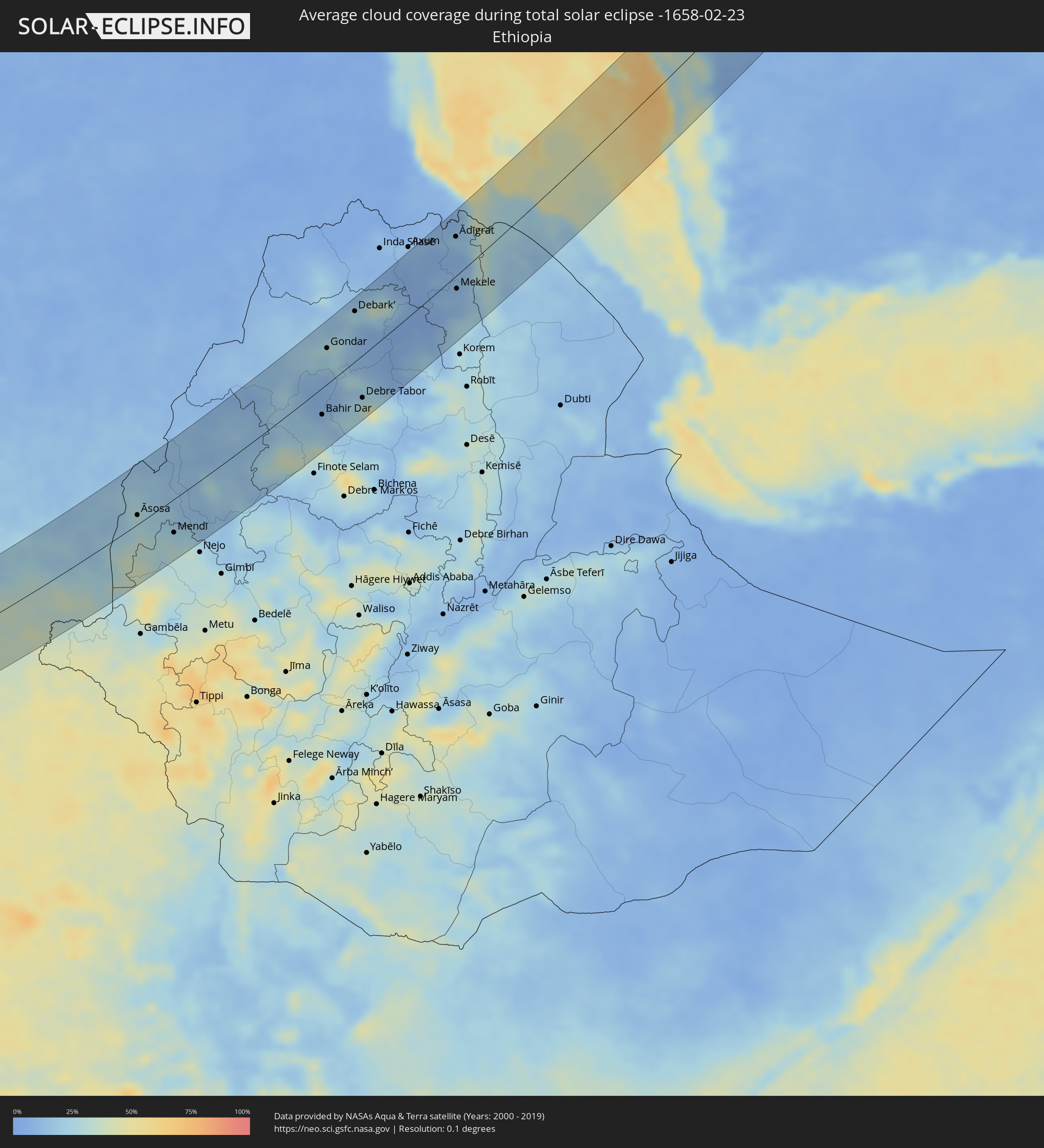 Ethiopia
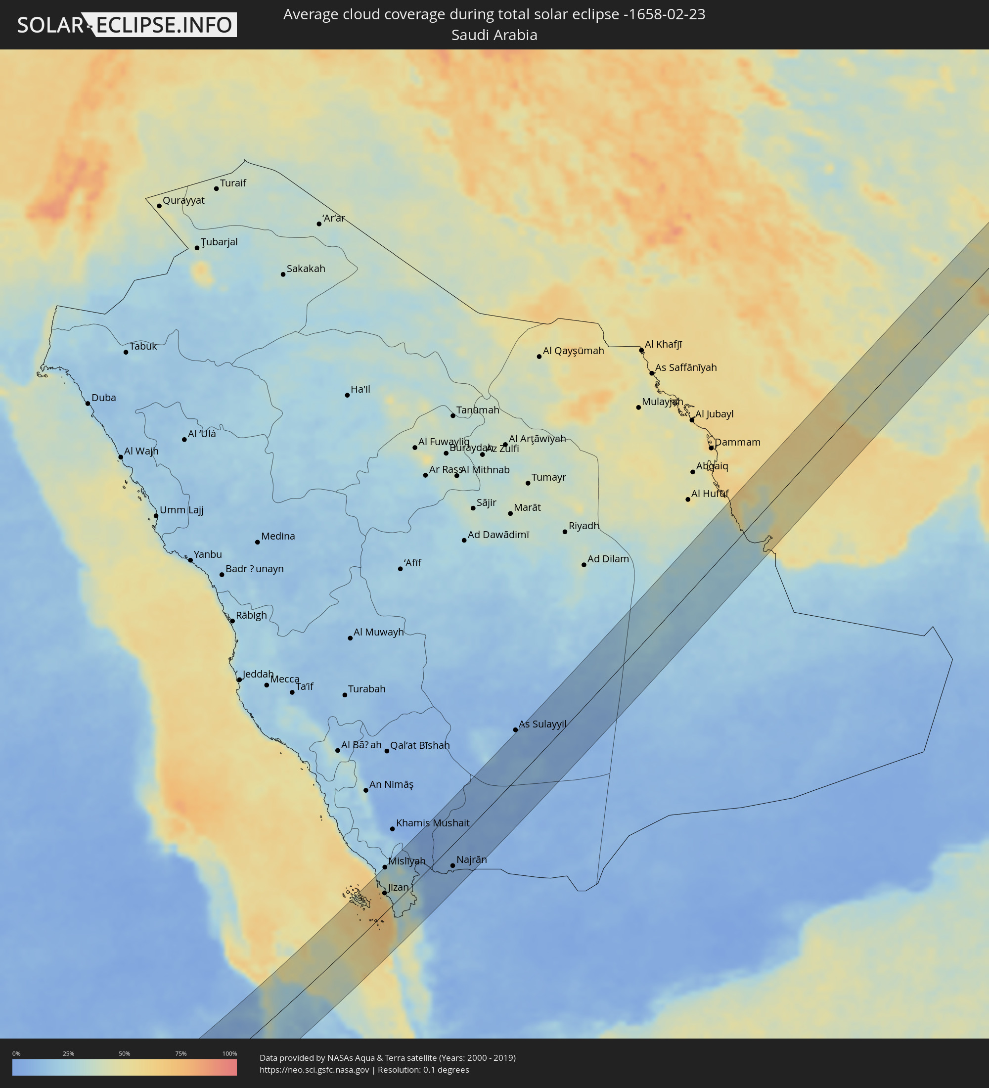 Saudi Arabia
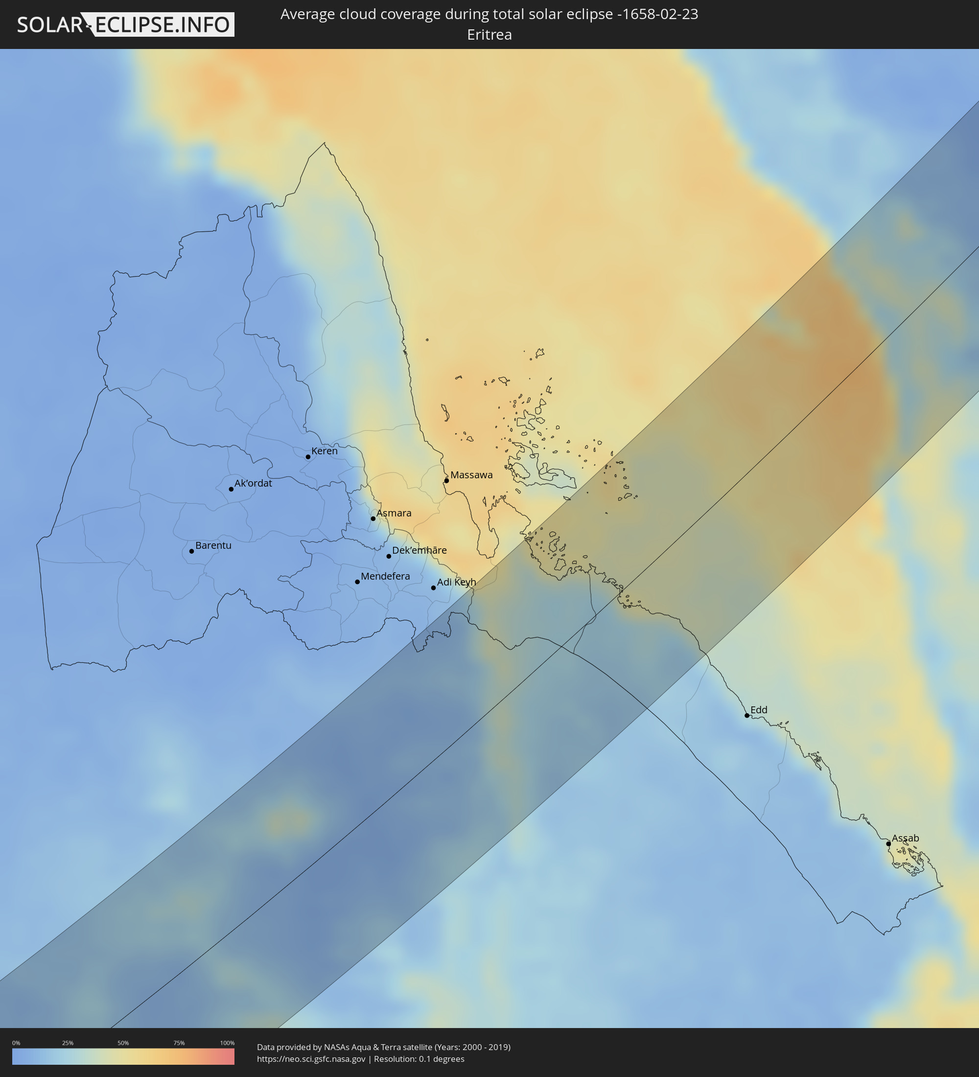 Eritrea
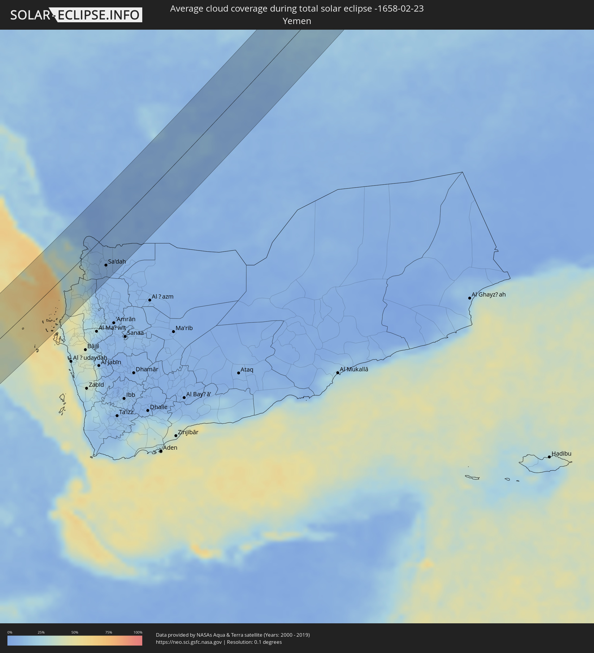 Yemen
Yemen
 Iran
Iran
 Kazakhstan
 Bahrain
 Qatar
Qatar
 United Arab Emirates
 Turkmenistan
 Uzbekistan
 Afghanistan
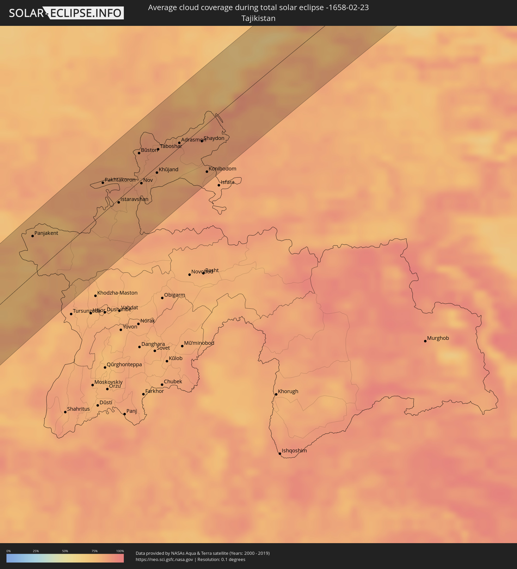 Tajikistan
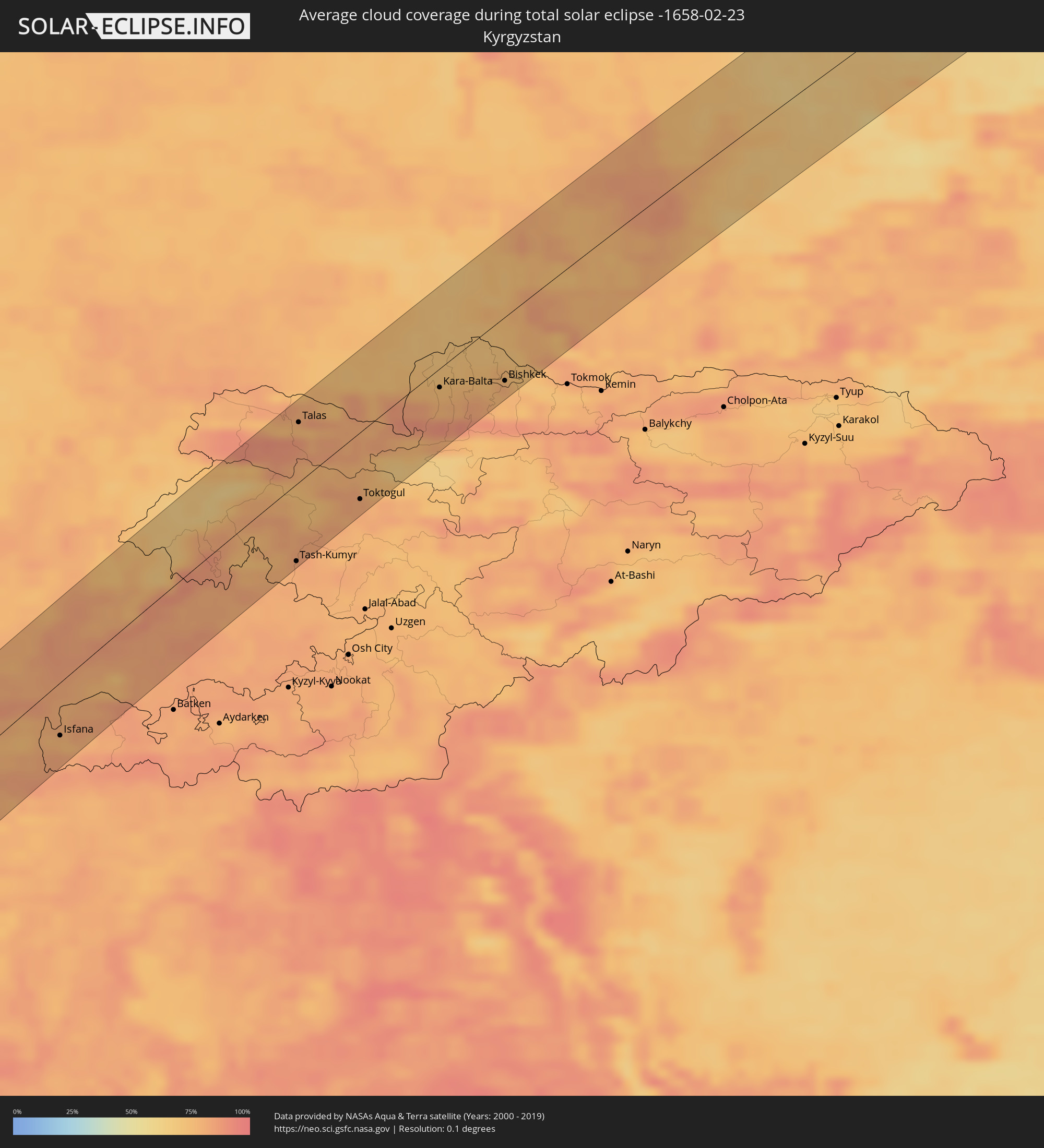 Kyrgyzstan
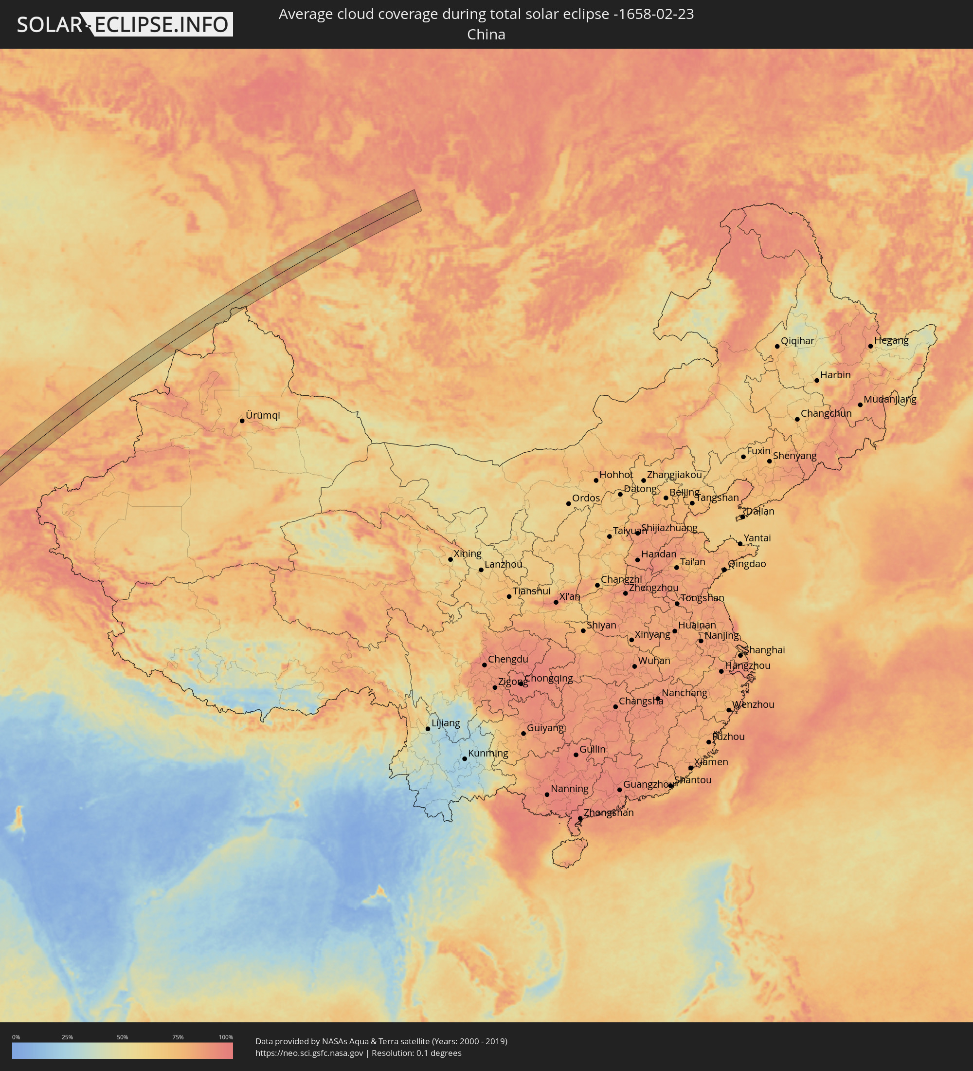 China
China
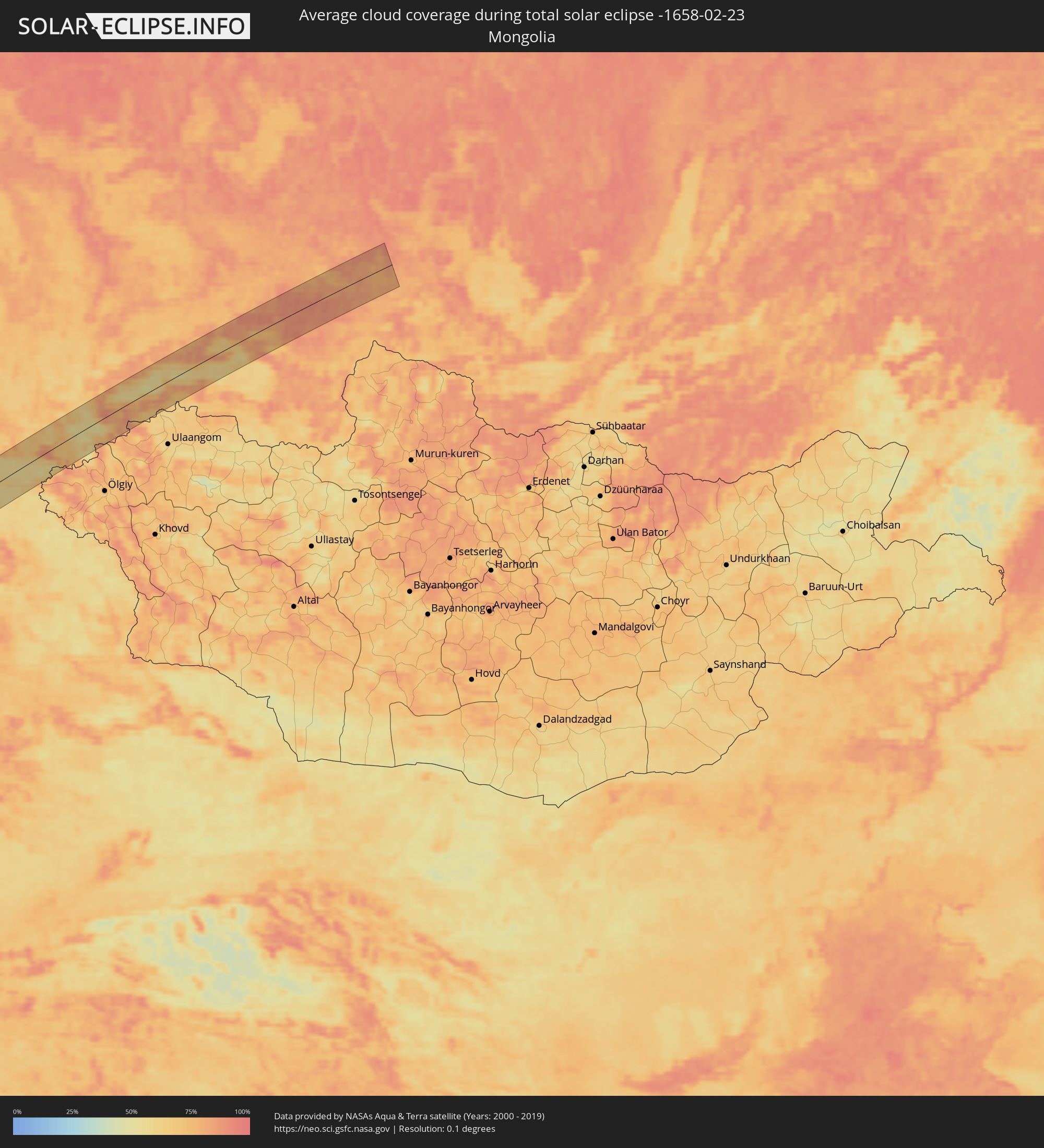 Mongolia
Cities inside the path of the eclipse
The following table shows all locations with a population of more than 5,000 inside the eclipse path. Cities which have more than 100,000 inhabitants are marked bold. A click at the locations opens a detailed map.
| City | Type | Eclipse duration | Local time of max. eclipse | Distance to central line | Ø Cloud coverage |
|
Robertsport, Grand Cape Mount
|
total | - | 06:35:07 UTC-00:43 | 21 km | 71% |
|
Tubmanburg, Bomi
|
total | - | 06:35:22 UTC-00:43 | 49 km | 79% |
|
Monrovia, Montserrado
|
total | - | 06:34:55 UTC-00:43 | 12 km | 81% |
|
Bensonville, Montserrado
|
total | - | 06:35:05 UTC-00:43 | 9 km | 89% |
|
Kakata, Margibi
|
total | - | 06:35:14 UTC-00:43 | 25 km | 86% |
|
Buchanan, Grand Bassa
|
total | - | 06:34:48 UTC-00:43 | 37 km | 78% |
|
Zwedru, Grand Gedeh
|
total | - | 06:35:37 UTC-00:43 | 33 km | 82% |
|
Fish Town, River Gee
|
total | - | 06:35:01 UTC-00:43 | 55 km | 88% |
|
Soubré, Bas-Sassandra
|
total | - | 07:03:02 UTC-00:16 | 40 km | 89% |
|
Sassandra, Bas-Sassandra
|
total | - | 07:02:35 UTC-00:16 | 38 km | 80% |
|
Grand-Lahou, Lagunes
|
total | - | 07:03:15 UTC-00:16 | 6 km | 85% |
|
Dabou, Lagunes
|
total | - | 07:03:45 UTC-00:16 | 41 km | 81% |
|
Abidjan, Abidjan
|
total | - | 07:03:57 UTC-00:16 | 48 km | 90% |
|
Bingerville, Abidjan
|
total | - | 07:04:03 UTC-00:16 | 55 km | 90% |
|
Grand-Bassam, Comoé
|
total | - | 07:04:01 UTC-00:16 | 43 km | 88% |
|
Bonoua
|
total | - | 07:04:09 UTC-00:16 | 53 km | 87% |
|
Axim, Western
|
total | - | 07:19:54 UTC-00:00 | 36 km | 87% |
|
Takoradi, Western
|
total | - | 07:20:13 UTC-00:00 | 47 km | 90% |
|
Sekondi-Takoradi, Western
|
total | - | 07:20:18 UTC-00:00 | 54 km | 89% |
|
Luba, Bioko Sur
|
total | - | 07:42:43 UTC+00:13 | 20 km | 90% |
|
Malabo, Bioko Norte
|
total | - | 07:43:17 UTC+00:13 | 54 km | 90% |
|
Rebola, Bioko Norte
|
total | - | 07:43:19 UTC+00:13 | 50 km | 94% |
|
Kribi, South
|
total | - | 07:43:49 UTC+00:13 | 33 km | 87% |
|
Dizangué, Littoral
|
total | - | 07:44:47 UTC+00:13 | 60 km | 94% |
|
Edéa, Littoral
|
total | - | 07:45:00 UTC+00:13 | 64 km | 94% |
|
Lolodorf, South
|
total | - | 07:45:10 UTC+00:13 | 2 km | 91% |
|
Eséka, Centre
|
total | - | 07:45:39 UTC+00:13 | 48 km | 95% |
|
Ébolowa, South
|
total | - | 07:45:21 UTC+00:13 | 35 km | 91% |
|
Mbalmayo, Centre
|
total | - | 07:46:28 UTC+00:13 | 33 km | 92% |
|
Sangmélima, South
|
total | - | 07:46:29 UTC+00:13 | 32 km | 92% |
|
Akonolinga, Centre
|
total | - | 07:47:46 UTC+00:13 | 60 km | 92% |
|
Yokadouma, East
|
total | - | 07:51:34 UTC+00:13 | 18 km | 86% |
|
Nola, Sangha-Mbaéré
|
total | - | 07:53:08 UTC+00:13 | 10 km | 83% |
|
Mbaïki, Lobaye
|
total | - | 07:56:44 UTC+00:13 | 23 km | 81% |
|
Bimbo, Ombella-M'Poko
|
total | - | 07:57:58 UTC+00:13 | 60 km | 80% |
|
Bangui, Bangui
|
total | - | 07:58:21 UTC+00:13 | 69 km | 78% |
|
Libenge, Équateur
|
total | - | 07:57:35 UTC+00:13 | 11 km | 75% |
|
Gemena, Équateur
|
total | - | 07:59:03 UTC+00:13 | 75 km | 82% |
|
Bosobolo, Équateur
|
total | - | 08:00:29 UTC+00:13 | 26 km | 78% |
|
Gbadolite, Équateur
|
total | - | 08:02:39 UTC+00:13 | 11 km | 76% |
|
Mobaye, Basse-Kotto
|
total | - | 08:03:02 UTC+00:13 | 11 km | 73% |
|
Kembé, Basse-Kotto
|
total | - | 08:04:47 UTC+00:13 | 27 km | 71% |
|
Bangassou, Mbomou
|
total | - | 08:06:45 UTC+00:13 | 15 km | 67% |
|
Rafaï, Mbomou
|
total | - | 08:09:14 UTC+00:13 | 5 km | 63% |
|
Zemio, Haut-Mbomou
|
total | - | 08:11:50 UTC+00:13 | 27 km | 65% |
|
Obo, Haut-Mbomou
|
total | - | 08:15:13 UTC+00:13 | 38 km | 56% |
 Tambura, Western Equatoria
|
total | - | 10:10:29 UTC+02:06 | 56 km | 53% |
|
Tonj, Warrap
|
total | - | 10:15:49 UTC+02:06 | 62 km | 45% |
|
Rumbek, Lakes
|
total | - | 10:17:17 UTC+02:06 | 32 km | 48% |
|
Kurmuk, Blue Nile
|
total | - | 10:37:57 UTC+02:10 | 73 km | 19% |
|
Āsosa, Bīnshangul Gumuz
|
total | - | 10:54:49 UTC+02:27 | 13 km | 27% |
|
Mendī, Oromiya
|
total | - | 10:55:40 UTC+02:27 | 47 km | 26% |
|
Bahir Dar, Amhara
|
total | - | 11:04:12 UTC+02:27 | 35 km | 15% |
|
Gondar, Amhara
|
total | - | 11:06:11 UTC+02:27 | 47 km | 27% |
|
Werota, Amhara
|
total | - | 11:05:30 UTC+02:27 | 28 km | 16% |
|
Debark’, Amhara
|
total | - | 11:08:10 UTC+02:27 | 65 km | 23% |
|
Debre Tabor, Amhara
|
total | - | 11:06:07 UTC+02:27 | 55 km | 29% |
|
Ādīgrat, Tigray
|
total | - | 11:13:46 UTC+02:27 | 49 km | 17% |
|
Mekele, Tigray
|
total | - | 11:12:25 UTC+02:27 | 17 km | 12% |
|
Maych’ew, Tigray
|
total | - | 11:11:19 UTC+02:27 | 81 km | 23% |
|
Farasān, Jizan
|
total | - | 12:03:36 UTC+03:06 | 51 km | 53% |
|
Jizan, Jizan
|
total | - | 12:04:53 UTC+03:06 | 34 km | 44% |
|
Mislīyah, Jizan
|
total | - | 12:05:51 UTC+03:06 | 78 km | 29% |
|
Şabyā, Jizan
|
total | - | 12:05:29 UTC+03:06 | 49 km | 34% |
|
Mizhirah, Jizan
|
total | - | 12:05:10 UTC+03:06 | 15 km | 37% |
|
Abū ‘Arīsh, Jizan
|
total | - | 12:05:38 UTC+03:06 | 19 km | 37% |
|
Al Jarādīyah, Jizan
|
total | - | 12:05:09 UTC+03:06 | 18 km | 30% |
|
Şāmitah, Jizan
|
total | - | 12:05:15 UTC+03:06 | 19 km | 30% |
|
Sa'dah, Şa‘dah
|
total | - | 12:07:37 UTC+03:06 | 53 km | 7% |
|
Najrān, Najran
|
total | - | 12:09:20 UTC+03:06 | 38 km | 10% |
|
Dukhān, Baladīyat ar Rayyān
|
total | - | 12:53:39 UTC+03:26 | 61 km | 48% |
|
Ash Shayḩānīyah, Baladīyat ar Rayyān
|
total | - | 12:54:24 UTC+03:26 | 24 km | 41% |
|
Umm Şalāl ‘Alī, Baladīyat Umm Şalāl
|
total | - | 12:54:50 UTC+03:26 | 18 km | 40% |
|
Umm Şalāl Muḩammad, Baladīyat Umm Şalāl
|
total | - | 12:54:47 UTC+03:26 | 13 km | 39% |
|
Az̧ Z̧a‘āyin, Baladīyat az̧ Z̧a‘āyin
|
total | - | 12:55:07 UTC+03:26 | 20 km | 49% |
|
Al Khawr, Al Khawr
|
total | - | 12:55:18 UTC+03:26 | 26 km | 47% |
|
Doha, Baladīyat ad Dawḩah
|
total | - | 12:54:49 UTC+03:26 | 5 km | 42% |
|
Al Wukayr, Al Wakrah
|
total | - | 12:54:41 UTC+03:26 | 16 km | 37% |
|
Musay‘īd, Al Wakrah
|
total | - | 12:54:31 UTC+03:26 | 29 km | 46% |
|
Al Wakrah, Al Wakrah
|
total | - | 12:54:50 UTC+03:26 | 20 km | 44% |
|
Gerāsh, Fars
|
total | - | 13:01:47 UTC+03:25 | 17 km | 41% |
|
Dārāb, Fars
|
total | - | 13:03:36 UTC+03:25 | 36 km | 50% |
|
Sirjan, Kerman
|
total | - | 13:06:08 UTC+03:25 | 8 km | 40% |
|
Rafsanjān, Kerman
|
total | - | 13:07:31 UTC+03:25 | 59 km | 41% |
|
Zarand, Kerman
|
total | - | 13:08:46 UTC+03:25 | 50 km | 50% |
|
Bardsīr, Kerman
|
total | - | 13:08:00 UTC+03:25 | 19 km | 45% |
|
Rāvar, Kerman
|
total | - | 13:09:32 UTC+03:25 | 68 km | 43% |
|
Kerman, Kerman
|
total | - | 13:09:06 UTC+03:25 | 26 km | 50% |
|
Bīrjand, Khorāsān-e Jonūbī
|
total | - | 13:14:21 UTC+03:25 | 27 km | 46% |
|
Kafir Qala, Herat
|
total | - | 13:52:20 UTC+04:00 | 47 km | 60% |
|
Kuhsān, Herat
|
total | - | 13:52:30 UTC+04:00 | 38 km | 60% |
|
Zindah Jān, Herat
|
total | - | 13:53:03 UTC+04:00 | 22 km | 57% |
|
Qarah Bāgh, Herat
|
total | - | 13:53:26 UTC+04:00 | 24 km | 67% |
|
Chahār Burj, Herat
|
total | - | 13:53:35 UTC+04:00 | 58 km | 60% |
|
Herāt, Herat
|
total | - | 13:53:39 UTC+04:00 | 51 km | 68% |
|
Serhetabat, Mary
|
total | - | 13:47:53 UTC+03:53 | 14 km | 77% |
|
Karukh, Herat
|
total | - | 13:54:14 UTC+04:00 | 65 km | 60% |
|
Ghormach, Badghis
|
total | - | 13:56:24 UTC+04:00 | 40 km | 76% |
|
Andkhōy, Faryab
|
total | - | 13:58:33 UTC+04:00 | 23 km | 80% |
|
Atamyrat, Lebap
|
total | - | 13:52:30 UTC+03:53 | 44 km | 75% |
|
Qarqīn, Jowzjan
|
total | - | 13:59:47 UTC+04:00 | 40 km | 68% |
|
Gowurdak, Lebap
|
total | - | 13:53:27 UTC+03:53 | 8 km | 77% |
|
Shahrisabz, Qashqadaryo
|
total | - | 14:29:02 UTC+04:27 | 49 km | 71% |
|
Urgut, Samarqand
|
total | - | 14:29:34 UTC+04:27 | 54 km | 80% |
|
Panjakent, Viloyati Sughd
|
total | - | 14:37:18 UTC+04:35 | 40 km | 78% |
|
Guliston, Sirdaryo
|
total | - | 14:31:23 UTC+04:27 | 57 km | 78% |
|
Istaravshan, Viloyati Sughd
|
total | - | 14:38:50 UTC+04:35 | 3 km | 75% |
|
Bekobod, Toshkent
|
total | - | 14:31:50 UTC+04:27 | 8 km | 84% |
|
Bŭston, Viloyati Sughd
|
total | - | 14:39:15 UTC+04:35 | 29 km | 81% |
|
Nov, Viloyati Sughd
|
total | - | 14:39:15 UTC+04:35 | 4 km | 82% |
|
Proletar, Viloyati Sughd
|
total | - | 14:39:23 UTC+04:35 | 10 km | 80% |
|
Isfana, Batken
|
total | - | 15:02:33 UTC+04:58 | 39 km | 78% |
|
Suluktu, Batken
|
total | - | 15:02:37 UTC+04:58 | 33 km | 77% |
|
Olmaliq, Toshkent
|
total | - | 14:32:15 UTC+04:27 | 42 km | 84% |
|
Khŭjand, Viloyati Sughd
|
total | - | 14:39:31 UTC+04:35 | 7 km | 81% |
|
Chkalov, Viloyati Sughd
|
total | - | 14:39:35 UTC+04:35 | 15 km | 79% |
|
Adrasmon, Viloyati Sughd
|
total | - | 14:39:55 UTC+04:35 | 4 km | 82% |
|
Angren, Toshkent
|
total | - | 14:32:48 UTC+04:27 | 27 km | 78% |
|
Shaydon, Viloyati Sughd
|
total | - | 14:40:17 UTC+04:35 | 14 km | 82% |
|
Konibodom, Viloyati Sughd
|
total | - | 14:40:19 UTC+04:35 | 50 km | 82% |
|
Qo‘qon, Fergana
|
total | - | 14:33:32 UTC+04:27 | 58 km | 83% |
|
Chust Shahri, Namangan
|
total | - | 14:33:51 UTC+04:27 | 33 km | 81% |
|
Kosonsoy, Namangan
|
total | - | 14:34:10 UTC+04:27 | 29 km | 78% |
|
Namangan, Namangan
|
total | - | 14:34:16 UTC+04:27 | 57 km | 80% |
|
Tash-Kumyr, Jalal-Abad
|
total | - | 15:05:18 UTC+04:58 | 56 km | 80% |
|
Talas, Talas
|
total | - | 15:05:20 UTC+04:58 | 44 km | 77% |
|
Lugovoye, Zhambyl
|
total | - | 14:29:13 UTC+04:21 | 52 km | 74% |
|
Lugovoy, Zhambyl
|
total | - | 14:29:15 UTC+04:21 | 53 km | 74% |
|
Toktogul, Jalal-Abad
|
total | - | 15:05:58 UTC+04:58 | 49 km | 81% |
|
Merke, Zhambyl
|
total | - | 14:29:37 UTC+04:21 | 25 km | 73% |
|
Oytal, Zhambyl
|
total | - | 14:29:42 UTC+04:21 | 24 km | 73% |
|
Kaindy, Chüy
|
total | - | 15:06:35 UTC+04:58 | 4 km | 76% |
|
Chu, Zhambyl
|
total | - | 14:30:04 UTC+04:21 | 59 km | 70% |
|
Kara-Balta, Chüy
|
total | - | 15:06:44 UTC+04:58 | 14 km | 75% |
|
Sosnovka, Chüy
|
total | - | 15:06:47 UTC+04:58 | 32 km | 89% |
|
Bishkek, Bishkek
|
total | - | 15:07:22 UTC+04:58 | 46 km | 79% |
|
Kant, Chüy
|
total | - | 15:07:35 UTC+04:58 | 58 km | 70% |
|
Taldyqorghan, Almaty Oblysy
|
total | - | 14:33:08 UTC+04:21 | 19 km | 68% |
|
Ush-Tyube, Almaty Oblysy
|
total | - | 14:33:07 UTC+04:21 | 1 km | 64% |
|
Balpyk Bī, Almaty Oblysy
|
total | - | 14:33:23 UTC+04:21 | 43 km | 68% |
|
Taldykorgan, Almaty Oblysy
|
total | - | 14:33:27 UTC+04:21 | 39 km | 67% |
|
Urzhar, East Kazakhstan
|
total | - | 14:35:02 UTC+04:21 | 4 km | 57% |
|
Kosh-Agach, Altai Republic
|
total | - | 16:27:00 UTC+06:11 | 6 km | 69% |
|
Kyzyl-Mazhalyk, Tyva
|
total | - | 16:27:07 UTC+06:11 | 36 km | 55% |
|
Ak-Dovurak, Tyva
|
total | - | 16:27:06 UTC+06:11 | 39 km | 59% |
|
Chadan, Tyva
|
total | - | 16:27:25 UTC+06:11 | 14 km | 57% |
|
Shagonar, Tyva
|
total | - | 16:27:42 UTC+06:11 | 3 km | 58% |
|
Turan, Tyva
|
total | - | 16:27:41 UTC+06:11 | 19 km | 66% |
|
Kyzyl, Tyva
|
total | - | 16:28:08 UTC+06:11 | 40 km | 62% |