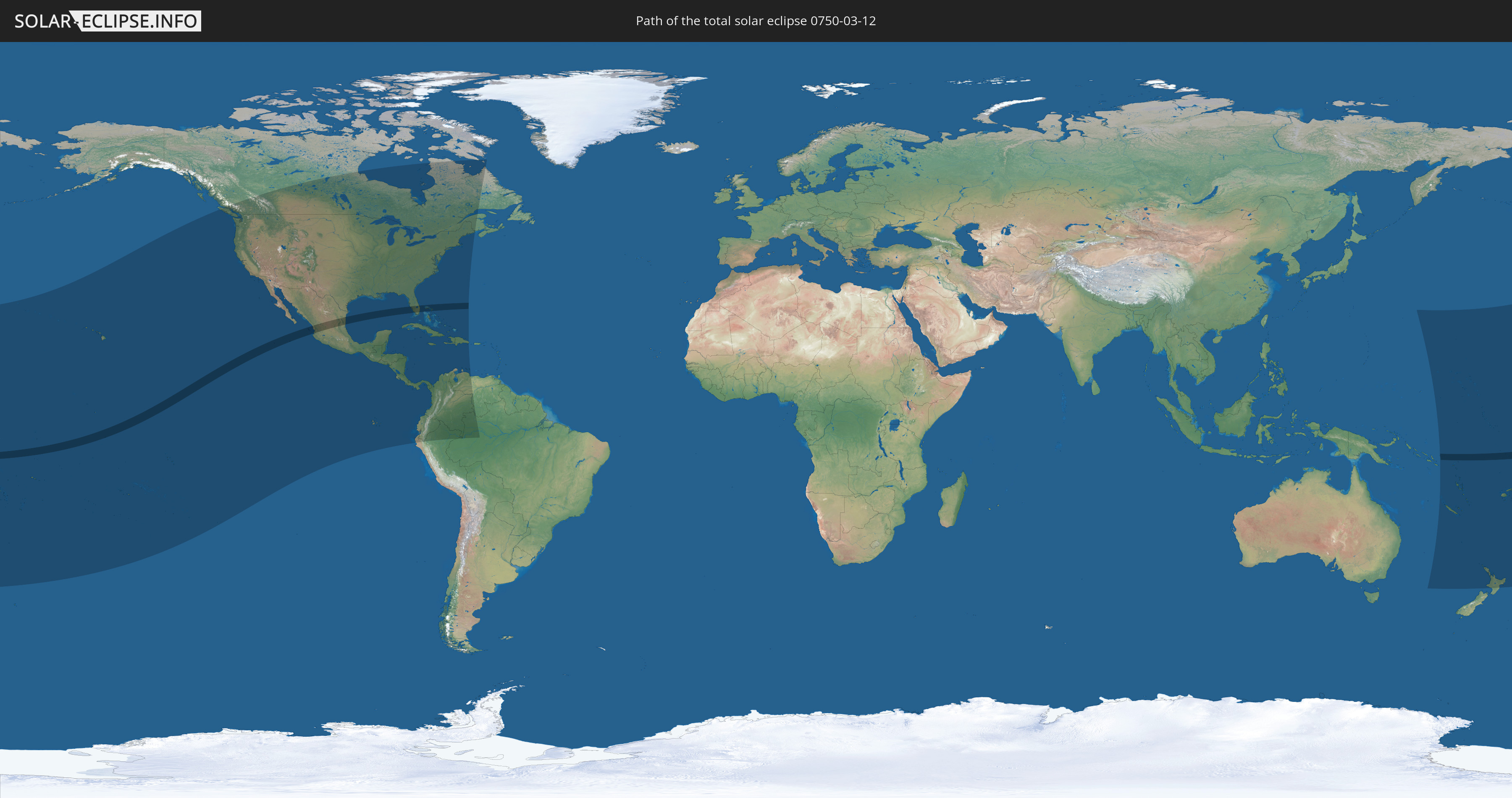
Total solar eclipse of 03/12/0750
| Day of week: | Sunday |
| Maximum duration of eclipse: | 05m46s |
| Maximum width of eclipse path: | 214 km |
| Saros cycle: | 90 |
| Coverage: | 100% |
| Magnitude: | 1.0647 |
| Gamma: | 0.16 |
Wo kann man die Sonnenfinsternis vom 03/12/0750 sehen?
Die Sonnenfinsternis am 03/12/0750 kann man in 44 Ländern als partielle Sonnenfinsternis beobachten.
Der Finsternispfad verläuft durch 6 Länder. Nur in diesen Ländern ist sie als total Sonnenfinsternis zu sehen.
In den folgenden Ländern ist die Sonnenfinsternis total zu sehen
 United States
 Kiribati
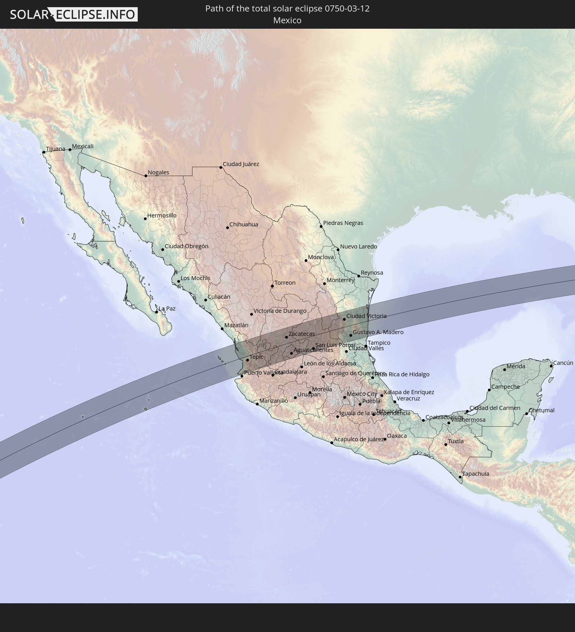 Mexico
 The Bahamas
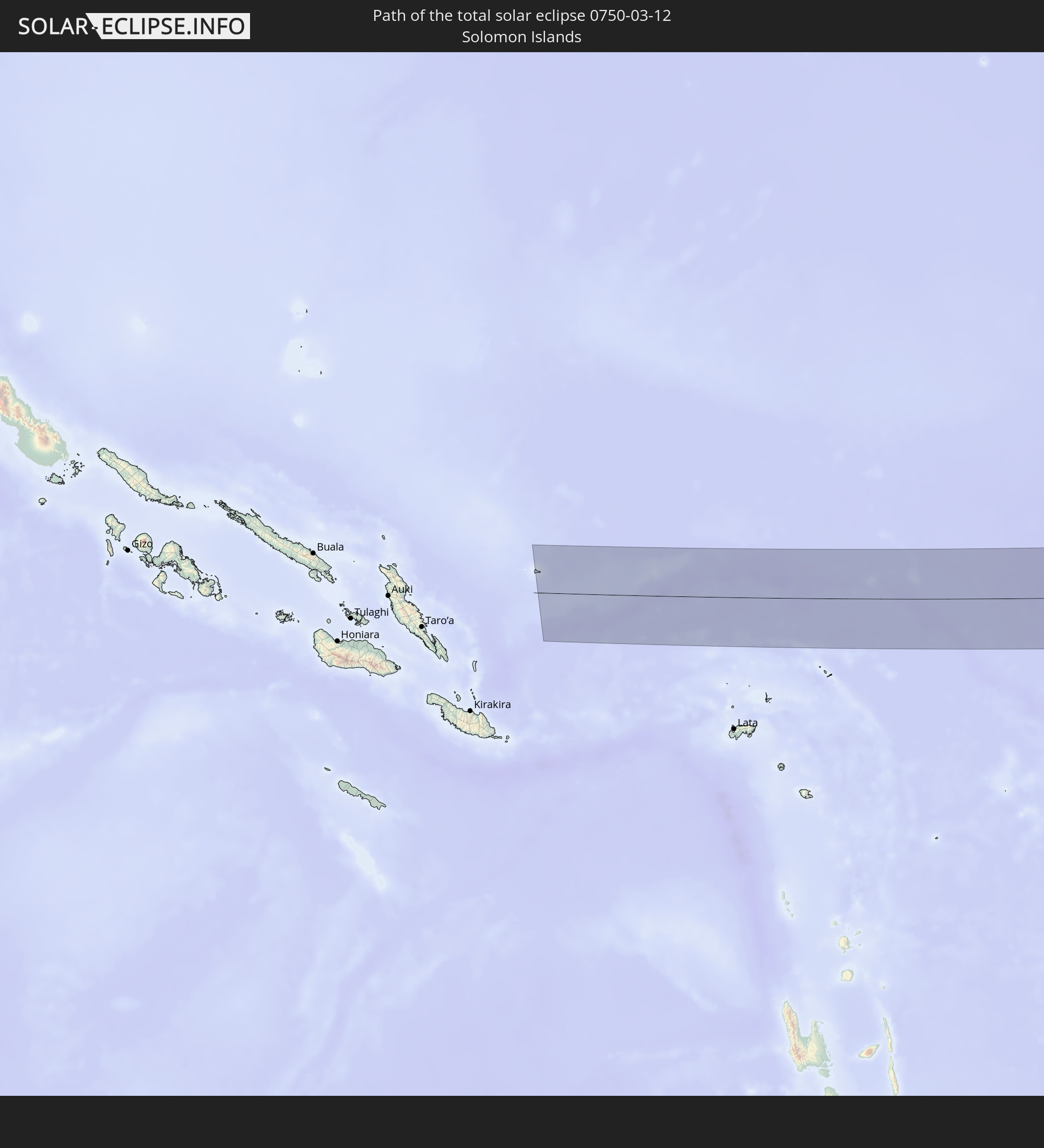 Solomon Islands
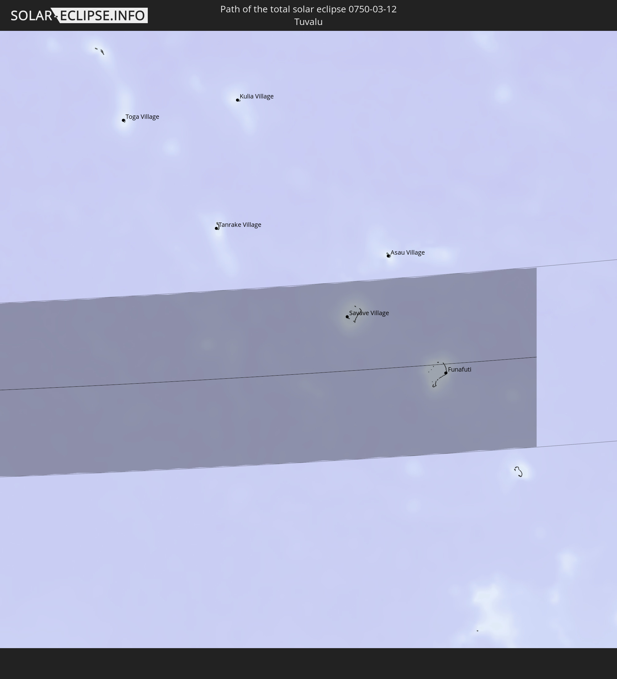 Tuvalu
In den folgenden Ländern ist die Sonnenfinsternis partiell zu sehen
 Fiji
Fiji
 United States
 New Zealand
 United States Minor Outlying Islands
 Wallis and Futuna
 Tonga
Tonga
 Kiribati
 Samoa
Samoa
 Tokelau
 American Samoa
 Niue
Niue
 Cook Islands
 French Polynesia
 Canada
 Pitcairn Islands
 Mexico
 Guatemala
 Ecuador
 El Salvador
 Honduras
 Belize
 Nicaragua
 Costa Rica
 Cuba
Cuba
 Panama
 Colombia
 Cayman Islands
 Peru
Peru
 The Bahamas
 Jamaica
 Haiti
Haiti
 Brazil
 Venezuela
 Turks and Caicos Islands
 Dominican Republic
 Aruba
Aruba
 Federated States of Micronesia
 Solomon Islands
 New Caledonia
 Marshall Islands
 Vanuatu
 Nauru
Nauru
 Norfolk Island
 Tuvalu
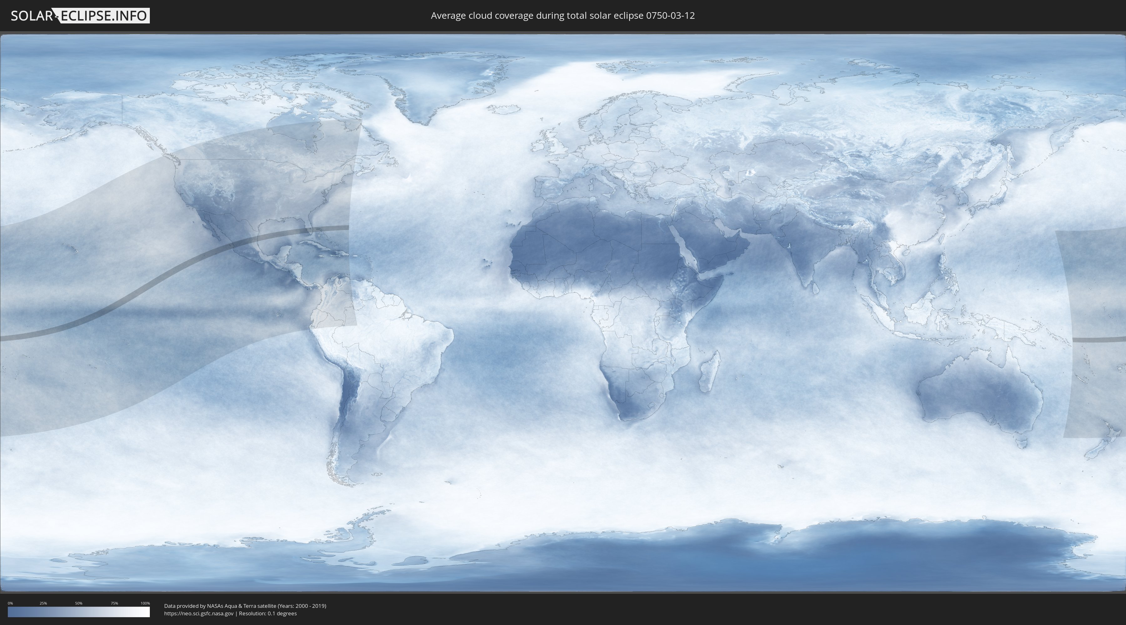
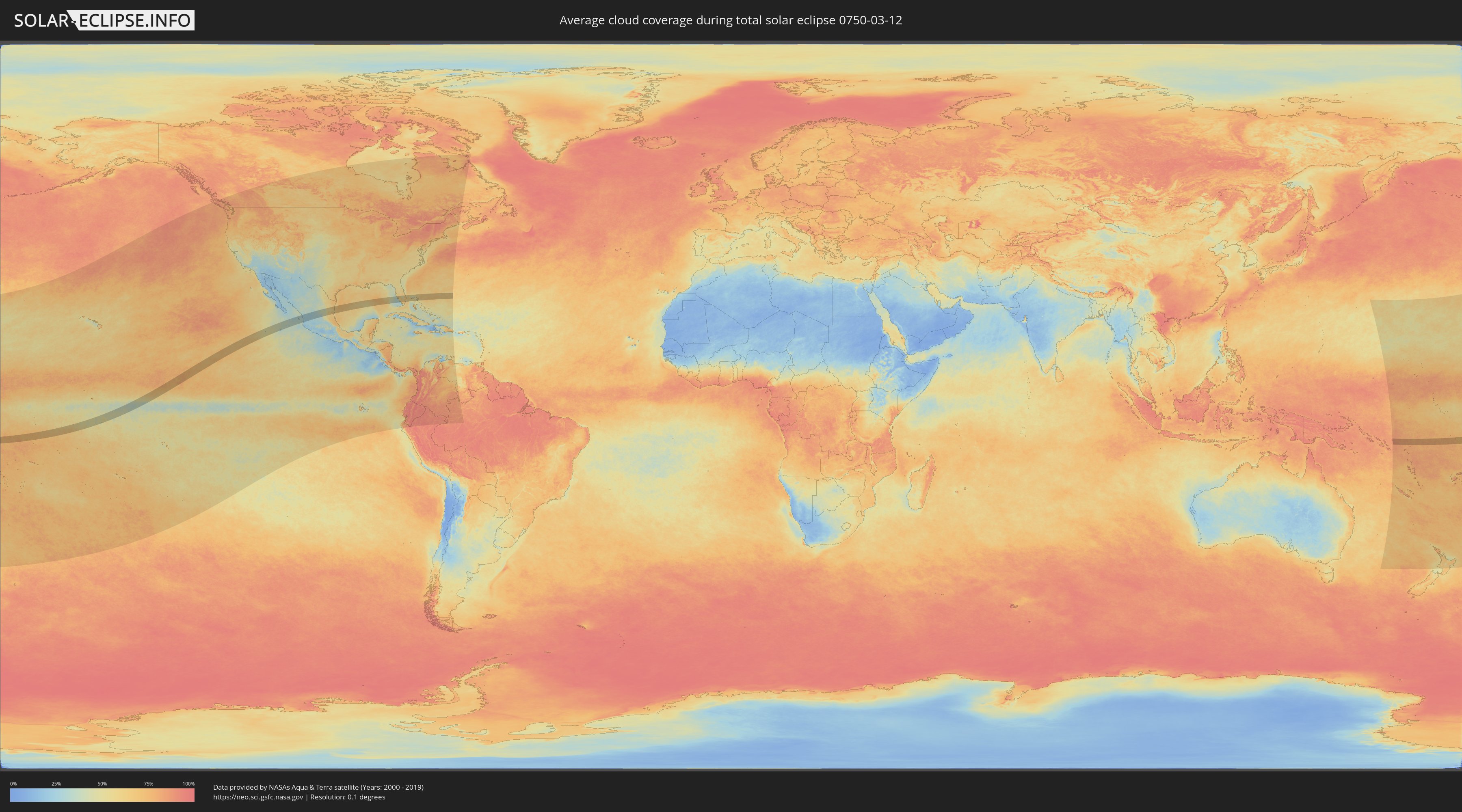
How will be the weather during the total solar eclipse on 03/12/0750?
Where is the best place to see the total solar eclipse of 03/12/0750?
The following maps show the average cloud coverage for the day of the total solar eclipse.
With the help of these maps, it is possible to find the place along the eclipse path, which has the best
chance of a cloudless sky.
Nevertheless, you should consider local circumstances and inform about the weather of your chosen
observation site.
The data is provided by NASAs satellites
AQUA and TERRA.
The cloud maps are averaged over a period of 19 years (2000 - 2019).
Detailed country maps
 United States
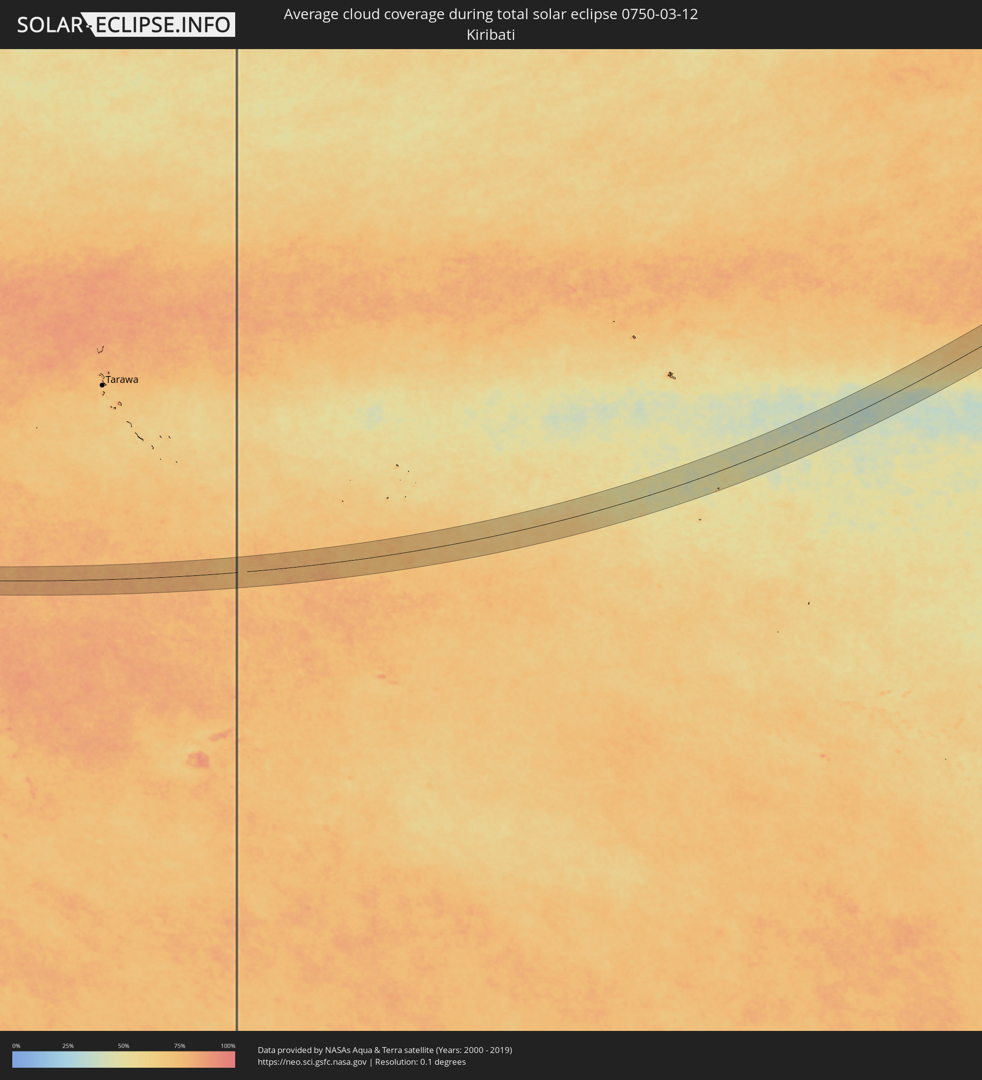 Kiribati
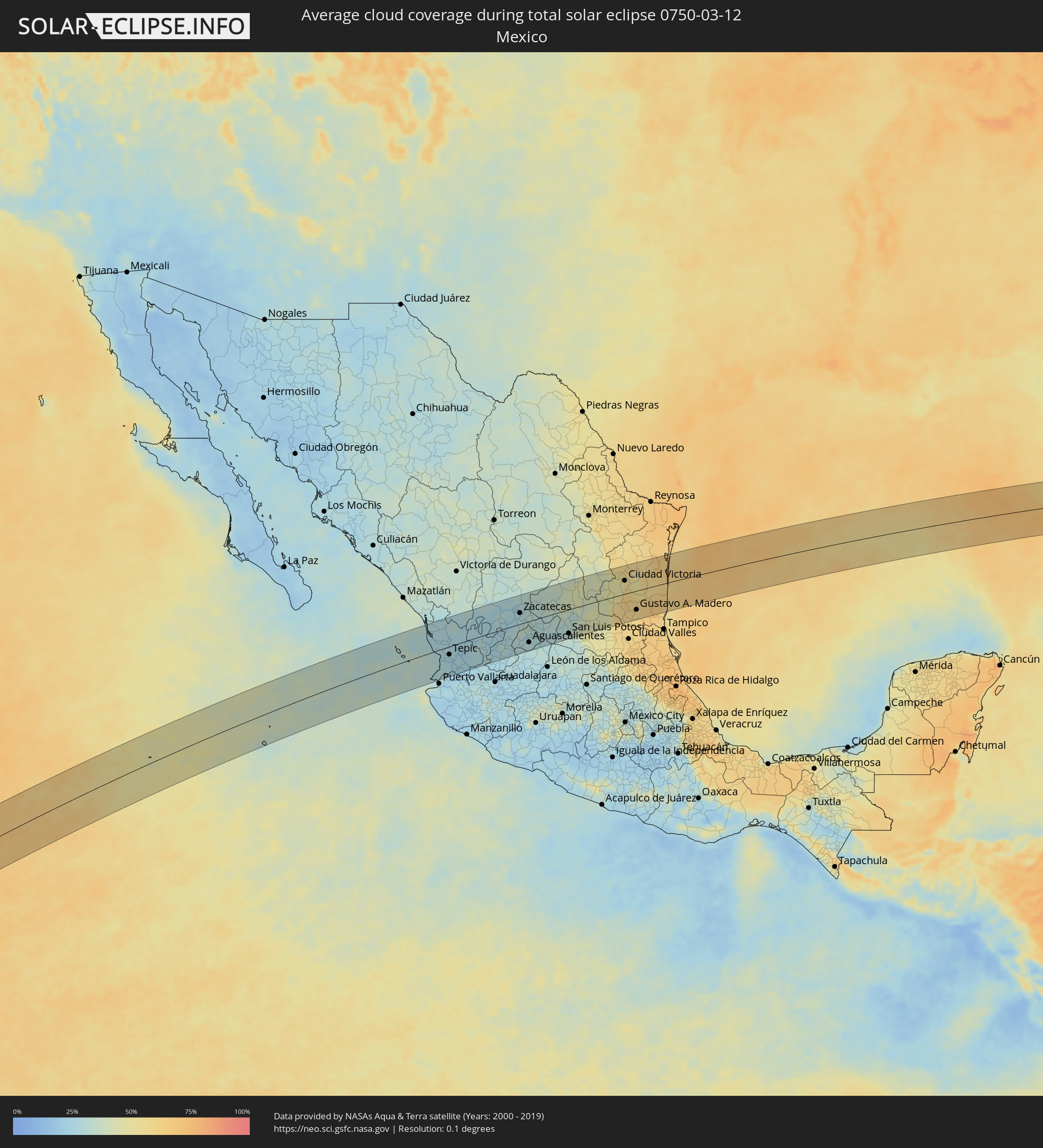 Mexico
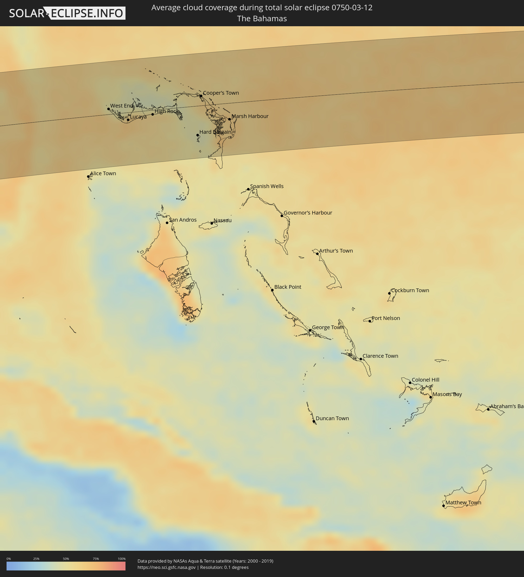 The Bahamas
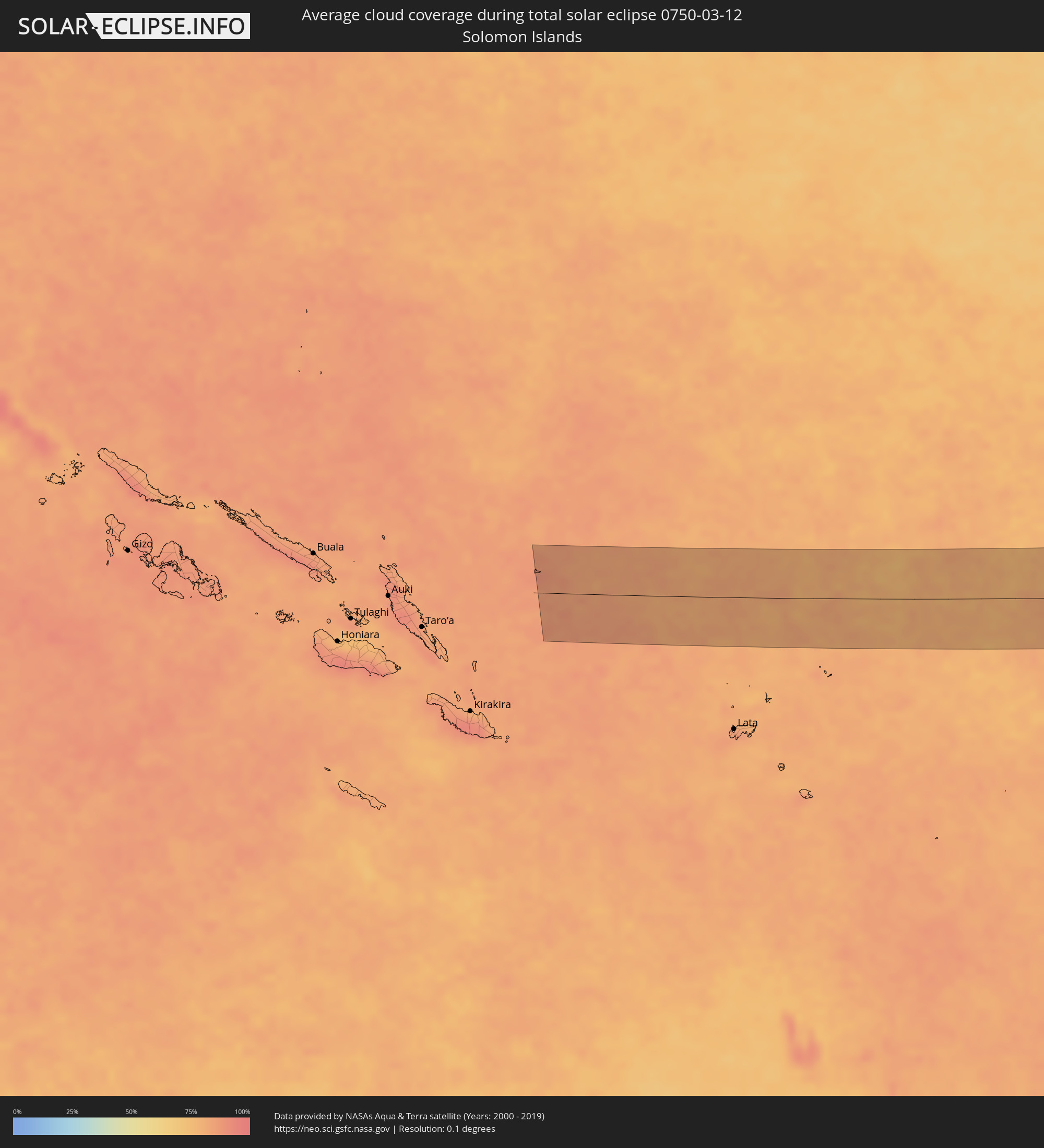 Solomon Islands
 Tuvalu
Cities inside the path of the eclipse
The following table shows all locations with a population of more than 5,000 inside the eclipse path. Cities which have more than 100,000 inhabitants are marked bold. A click at the locations opens a detailed map.
| City | Type | Eclipse duration | Local time of max. eclipse | Distance to central line | Ø Cloud coverage |
|
Acaponeta, Nayarit
|
total | - | 15:11:15 UTC-07:05 | 93 km | 28% |
|
Bucerías, Nayarit
|
total | - | 15:39:42 UTC-06:36 | 91 km | 29% |
|
San Blas, Nayarit
|
total | - | 15:11:01 UTC-07:05 | 10 km | 29% |
|
Valle de Banderas, Nayarit
|
total | - | 15:39:50 UTC-06:36 | 88 km | 28% |
|
Villa Hidalgo, Nayarit
|
total | - | 15:11:10 UTC-07:05 | 10 km | 27% |
|
Santiago Ixcuintla, Nayarit
|
total | - | 15:11:13 UTC-07:05 | 16 km | 29% |
|
San Juan de Abajo, Nayarit
|
total | - | 15:39:55 UTC-06:36 | 90 km | 28% |
|
Estación Ruiz, Nayarit
|
total | - | 15:11:21 UTC-07:05 | 29 km | 27% |
|
Las Varas, Nayarit
|
total | - | 15:11:05 UTC-07:05 | 53 km | 27% |
|
Compostela, Nayarit
|
total | - | 15:11:26 UTC-07:05 | 55 km | 25% |
|
Tepic, Nayarit
|
total | - | 15:11:32 UTC-07:05 | 26 km | 26% |
|
Jala, Nayarit
|
total | - | 15:12:01 UTC-07:05 | 84 km | 24% |
|
Ixtlán del Río, Nayarit
|
total | - | 15:12:05 UTC-07:05 | 93 km | 24% |
|
Valparaíso, Zacatecas
|
total | - | 15:42:47 UTC-06:36 | 66 km | 25% |
|
Tlaltenango de Sánchez Román, Zacatecas
|
total | - | 15:42:50 UTC-06:36 | 48 km | 28% |
|
Colotlán, Jalisco
|
total | - | 15:42:59 UTC-06:36 | 14 km | 25% |
|
Jerez de García Salinas, Zacatecas
|
total | - | 15:43:29 UTC-06:36 | 35 km | 25% |
|
Jalpa, Zacatecas
|
total | - | 15:43:12 UTC-06:36 | 73 km | 25% |
|
Villanueva, Zacatecas
|
total | - | 15:43:32 UTC-06:36 | 0 km | 26% |
|
Fresnillo, Zacatecas
|
total | - | 15:43:47 UTC-06:36 | 88 km | 27% |
|
Calvillo, Aguascalientes
|
total | - | 15:43:36 UTC-06:36 | 59 km | 30% |
|
Víctor Rosales, Zacatecas
|
total | - | 15:43:56 UTC-06:36 | 58 km | 26% |
|
Villa Hidalgo, Jalisco
|
total | - | 15:43:43 UTC-06:36 | 81 km | 29% |
|
Zacatecas, Zacatecas
|
total | - | 15:44:02 UTC-06:36 | 35 km | 27% |
|
Tacoaleche, Zacatecas
|
total | - | 15:44:16 UTC-06:36 | 36 km | 31% |
|
Trancoso, Zacatecas
|
total | - | 15:44:18 UTC-06:36 | 25 km | 30% |
|
San Pedro Piedra Gorda, Zacatecas
|
total | - | 15:44:14 UTC-06:36 | 6 km | 33% |
|
Rincón de Romos, Aguascalientes
|
total | - | 15:44:13 UTC-06:36 | 30 km | 28% |
|
Jesús Gómez Portugal (Margaritas), Aguascalientes
|
total | - | 15:44:11 UTC-06:36 | 55 km | 29% |
|
Jesús Gómez Portugal, Aguascalientes
|
total | - | 15:44:11 UTC-06:36 | 56 km | 29% |
|
Aguascalientes, Aguascalientes
|
total | - | 15:44:10 UTC-06:36 | 68 km | 29% |
|
Loreto, Zacatecas
|
total | - | 15:44:38 UTC-06:36 | 35 km | 30% |
|
Salinas de Hidalgo, San Luis Potosí
|
total | - | 15:45:04 UTC-06:36 | 5 km | 31% |
|
Ojuelos de Jalisco, Jalisco
|
total | - | 15:45:01 UTC-06:36 | 90 km | 29% |
|
Charcas, San Luis Potosí
|
total | - | 15:45:54 UTC-06:36 | 31 km | 39% |
|
San Luis Potosí, San Luis Potosí
|
total | - | 15:45:50 UTC-06:36 | 78 km | 34% |
|
Matehuala, San Luis Potosí
|
total | - | 15:46:33 UTC-06:36 | 73 km | 45% |
|
Cerritos, San Luis Potosí
|
total | - | 15:46:43 UTC-06:36 | 67 km | 44% |
|
Doctor Arroyo, Nuevo León
|
total | - | 15:47:05 UTC-06:36 | 63 km | 42% |
|
Tula, Tamaulipas
|
total | - | 15:47:29 UTC-06:36 | 22 km | 45% |
|
Ciudad del Maiz, San Luis Potosí
|
total | - | 15:47:29 UTC-06:36 | 89 km | 49% |
|
Guillermo Zúñiga, Tamaulipas
|
total | - | 15:48:14 UTC-06:36 | 73 km | 58% |
|
Ciudad Victoria, Tamaulipas
|
total | - | 15:48:15 UTC-06:36 | 43 km | 54% |
|
Ciudad Mante, Tamaulipas
|
total | - | 15:48:16 UTC-06:36 | 69 km | 58% |
|
Xicoténcatl, Tamaulipas
|
total | - | 15:48:21 UTC-06:36 | 43 km | 62% |
|
Gustavo A. Madero, Tamaulipas
|
total | - | 15:48:31 UTC-06:36 | 61 km | 61% |
|
Ursulo Galván, Tamaulipas
|
total | - | 15:48:58 UTC-06:36 | 88 km | 67% |
|
Soto la Marina, Tamaulipas
|
total | - | 15:49:15 UTC-06:36 | 21 km | 59% |
|
Aldama, Tamaulipas
|
total | - | 15:49:16 UTC-06:36 | 74 km | 67% |
|
Nuevo Progreso, Tamaulipas
|
total | - | 15:49:26 UTC-06:36 | 49 km | 66% |
|
Englewood, Florida
|
total | - | 17:37:08 UTC-05:00 | 76 km | 44% |
|
Rotonda, Florida
|
total | - | 17:37:10 UTC-05:00 | 66 km | 45% |
|
North Port, Florida
|
total | - | 17:37:10 UTC-05:00 | 83 km | 49% |
|
Port Charlotte, Florida
|
total | - | 17:37:14 UTC-05:00 | 74 km | 53% |
|
Cape Coral, Florida
|
total | - | 17:37:22 UTC-05:00 | 27 km | 55% |
|
McGregor, Florida
|
total | - | 17:37:23 UTC-05:00 | 26 km | 55% |
|
Cypress Lake, Florida
|
total | - | 17:37:24 UTC-05:00 | 23 km | 51% |
|
Villas, Florida
|
total | - | 17:37:25 UTC-05:00 | 24 km | 55% |
|
Bonita Springs, Florida
|
total | - | 17:37:29 UTC-05:00 | 0 km | 53% |
|
Gateway, Florida
|
total | - | 17:37:27 UTC-05:00 | 26 km | 59% |
|
Marco, Florida
|
total | - | 17:37:34 UTC-05:00 | 41 km | 44% |
|
Golden Gate, Florida
|
total | - | 17:37:33 UTC-05:00 | 18 km | 58% |
|
Lehigh Acres, Florida
|
total | - | 17:37:30 UTC-05:00 | 30 km | 60% |
|
Immokalee, Florida
|
total | - | 17:37:37 UTC-05:00 | 5 km | 60% |
|
Clewiston, Florida
|
total | - | 17:37:44 UTC-05:00 | 36 km | 51% |
|
Belle Glade, Florida
|
total | - | 17:37:51 UTC-05:00 | 25 km | 60% |
|
Weston, Florida
|
total | - | 17:38:03 UTC-05:00 | 42 km | 67% |
|
Sweetwater, Florida
|
total | - | 17:38:07 UTC-05:00 | 80 km | 69% |
|
Fountainebleau, Florida
|
total | - | 17:38:08 UTC-05:00 | 79 km | 64% |
|
Southwest Ranches, Florida
|
total | - | 17:38:05 UTC-05:00 | 47 km | 69% |
|
Miami Springs, Florida
|
total | - | 17:38:08 UTC-05:00 | 74 km | 64% |
|
Coral Springs, Florida
|
total | - | 17:38:04 UTC-05:00 | 25 km | 68% |
|
Palm City, Florida
|
total | - | 17:37:54 UTC-05:00 | 75 km | 64% |
|
Westview, Florida
|
total | - | 17:38:09 UTC-05:00 | 68 km | 61% |
|
Wellington, Florida
|
total | - | 17:38:00 UTC-05:00 | 18 km | 70% |
|
Lake Lucerne, Florida
|
total | - | 17:38:08 UTC-05:00 | 59 km | 65% |
|
Gladeview, Florida
|
total | - | 17:38:09 UTC-05:00 | 73 km | 57% |
|
Scott Lake, Florida
|
total | - | 17:38:08 UTC-05:00 | 61 km | 61% |
|
Pembroke Pines, Florida
|
total | - | 17:38:08 UTC-05:00 | 55 km | 65% |
|
Andover, Florida
|
total | - | 17:38:09 UTC-05:00 | 59 km | 65% |
|
Port Salerno, Florida
|
total | - | 17:37:55 UTC-05:00 | 71 km | 59% |
|
West Park, Florida
|
total | - | 17:38:09 UTC-05:00 | 57 km | 65% |
|
Miami, Florida
|
total | - | 17:38:11 UTC-05:00 | 80 km | 57% |
|
Melrose Park, Florida
|
total | - | 17:38:07 UTC-05:00 | 43 km | 65% |
|
Miami Shores, Florida
|
total | - | 17:38:10 UTC-05:00 | 71 km | 61% |
|
North Andrews Gardens, Florida
|
total | - | 17:38:08 UTC-05:00 | 35 km | 55% |
|
Fort Lauderdale, Florida
|
total | - | 17:38:08 UTC-05:00 | 42 km | 55% |
|
Kings Point, Florida
|
total | - | 17:38:05 UTC-05:00 | 7 km | 60% |
|
Wilton Manors, Florida
|
total | - | 17:38:08 UTC-05:00 | 38 km | 55% |
|
Hobe Sound, Florida
|
total | - | 17:37:58 UTC-05:00 | 61 km | 54% |
|
Pompano Beach Highlands, Florida
|
total | - | 17:38:07 UTC-05:00 | 25 km | 56% |
|
Jupiter, Florida
|
total | - | 17:38:00 UTC-05:00 | 47 km | 60% |
|
Lighthouse Point, Florida
|
total | - | 17:38:08 UTC-05:00 | 26 km | 56% |
|
Boca Raton, Florida
|
total | - | 17:38:07 UTC-05:00 | 17 km | 60% |
|
North Palm Beach, Florida
|
total | - | 17:38:02 UTC-05:00 | 34 km | 61% |
|
Lake Park, Florida
|
total | - | 17:38:02 UTC-05:00 | 32 km | 61% |
|
Boynton Beach, Florida
|
total | - | 17:38:06 UTC-05:00 | 1 km | 60% |
|
West Palm Beach, Florida
|
total | - | 17:38:04 UTC-05:00 | 22 km | 63% |
|
Lantana, Florida
|
total | - | 17:38:05 UTC-05:00 | 8 km | 62% |
|
Palm Beach, Florida
|
total | - | 17:38:04 UTC-05:00 | 21 km | 56% |
|
West End, West Grand Bahama
|
total | - | 17:28:55 UTC-05:09 | 8 km | 62% |
|
Freeport, Freeport
|
total | - | 17:29:02 UTC-05:09 | 12 km | 62% |
|
Lucaya, Freeport
|
total | - | 17:29:03 UTC-05:09 | 12 km | 62% |
|
High Rock, East Grand Bahama
|
total | - | 22:38:39 UTC+00:00 | 7 km | 58% |
|
Hard Bargain, Moore’s Island
|
total | - | 17:29:24 UTC-05:09 | 46 km | 49% |
|
Cooper’s Town, North Abaco
|
total | - | 17:29:18 UTC-05:09 | 15 km | 62% |
|
Marsh Harbour, Central Abaco
|
total | - | 17:29:30 UTC-05:09 | 26 km | 61% |
|
Savave Village, Nukufetau
|
total | - | 07:21:22 UTC+12:00 | 53 km | 77% |
|
Funafuti, Funafuti
|
total | - | 07:21:40 UTC+12:00 | 9 km | 76% |