Total solar eclipse of 07/05/2168
| Day of week: | Tuesday |
| Maximum duration of eclipse: | 07m26s |
| Maximum width of eclipse path: | 264 km |
| Saros cycle: | 139 |
| Coverage: | 100% |
| Magnitude: | 1.0807 |
| Gamma: | -0.166 |
Wo kann man die Sonnenfinsternis vom 07/05/2168 sehen?
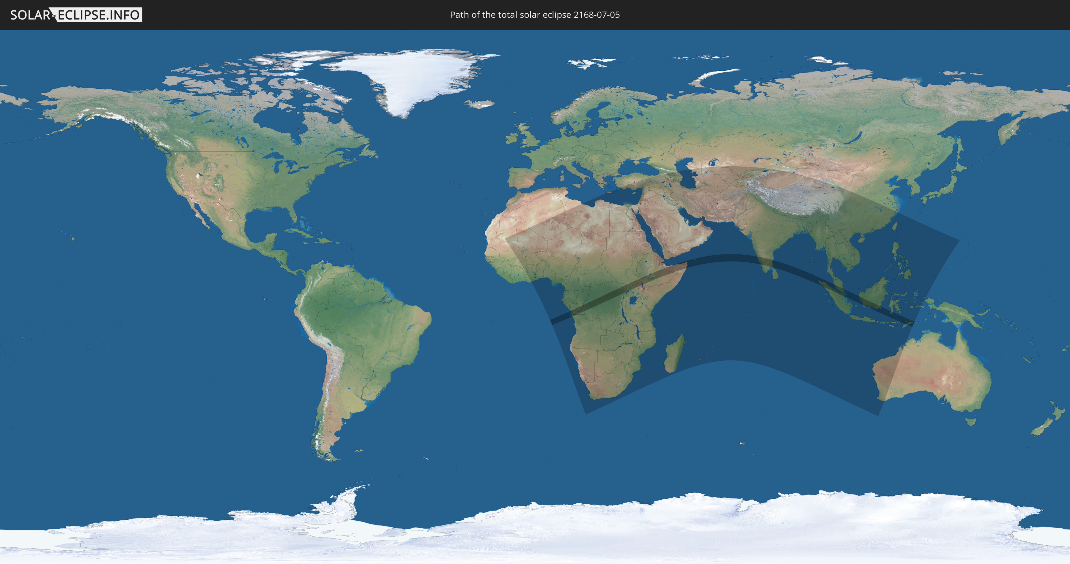
Die Sonnenfinsternis am 07/05/2168 kann man in 102 Ländern als partielle Sonnenfinsternis beobachten.
Der Finsternispfad verläuft durch 14 Länder. Nur in diesen Ländern ist sie als total Sonnenfinsternis zu sehen.
In den folgenden Ländern ist die Sonnenfinsternis total zu sehen
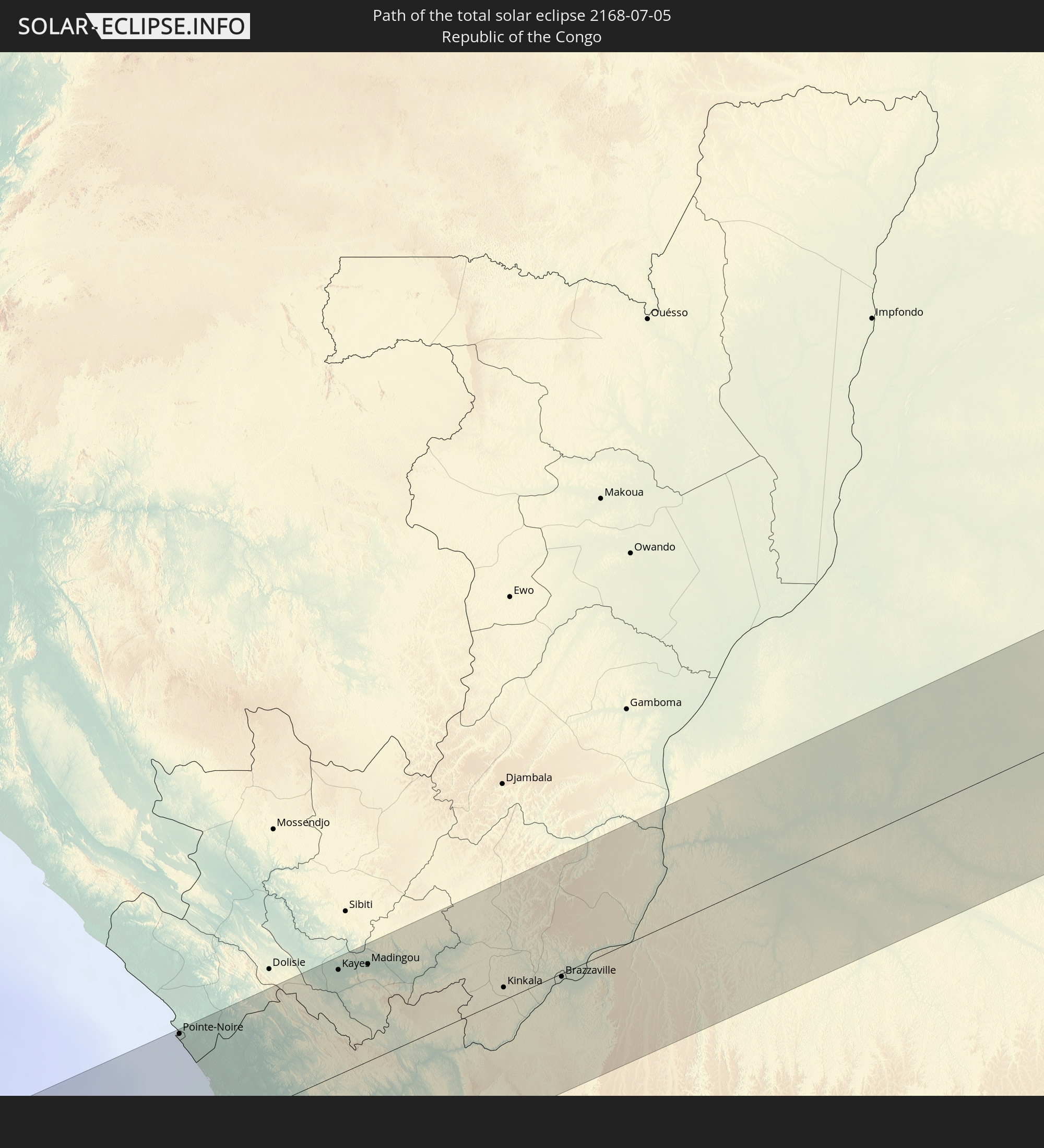 Republic of the Congo
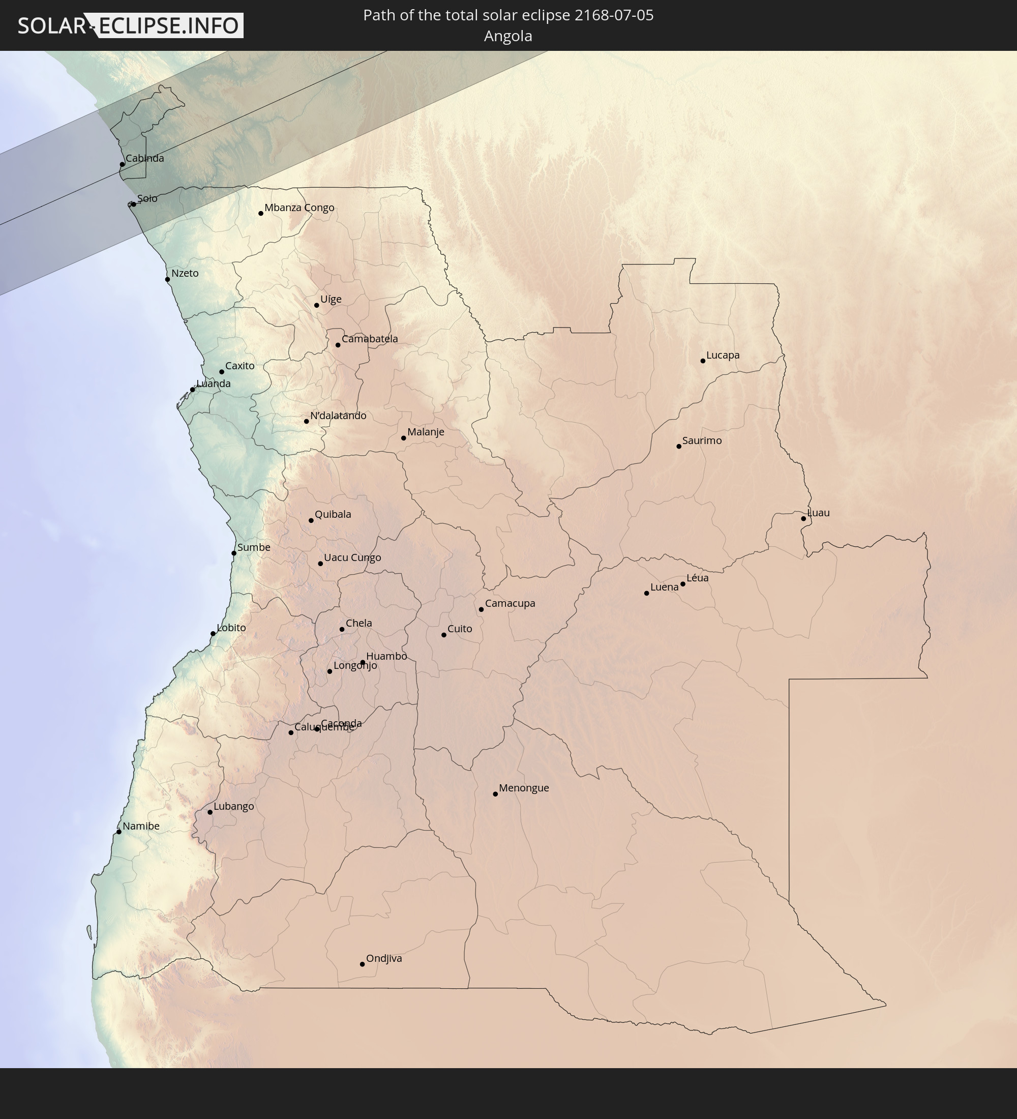 Angola
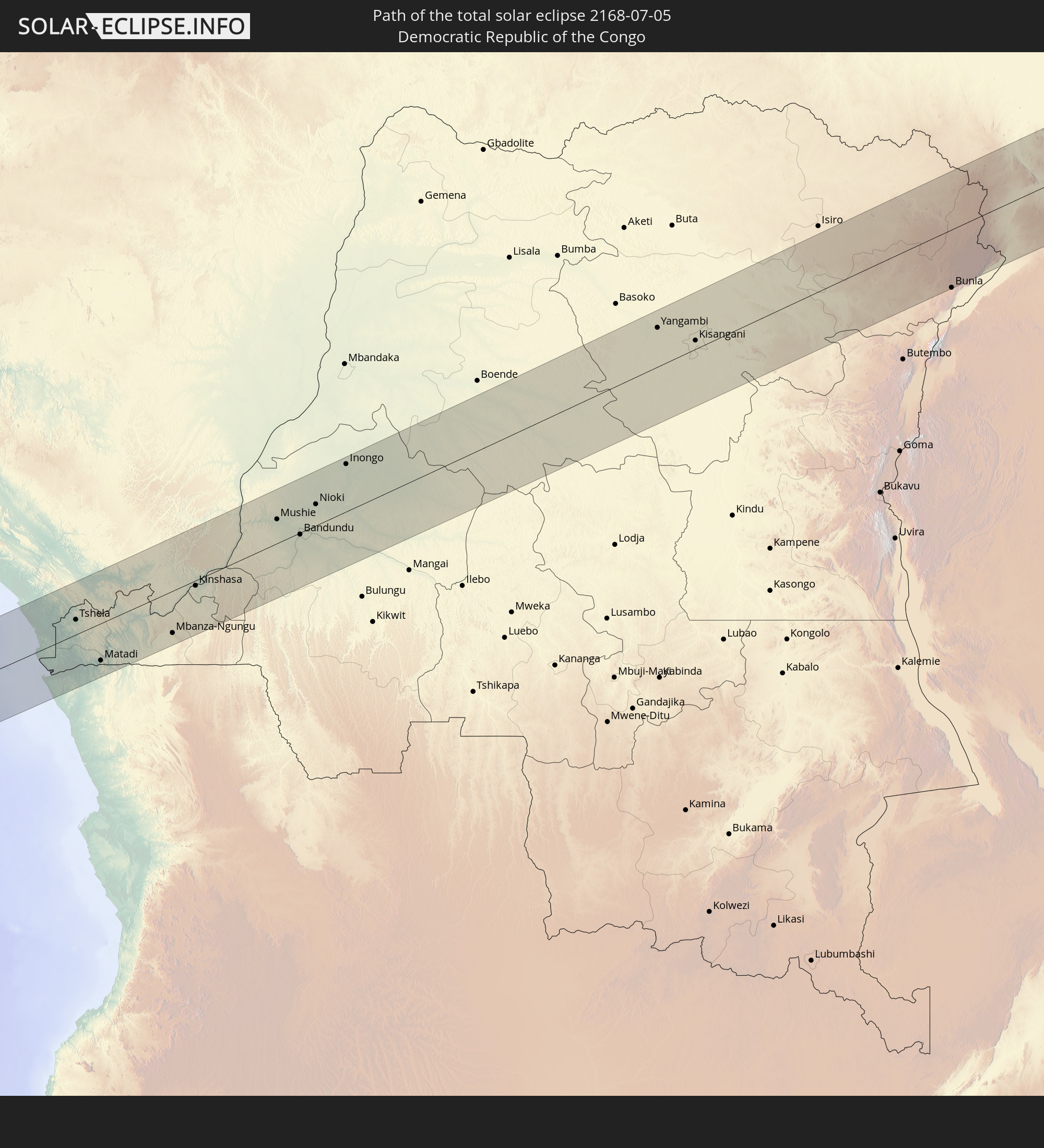 Democratic Republic of the Congo
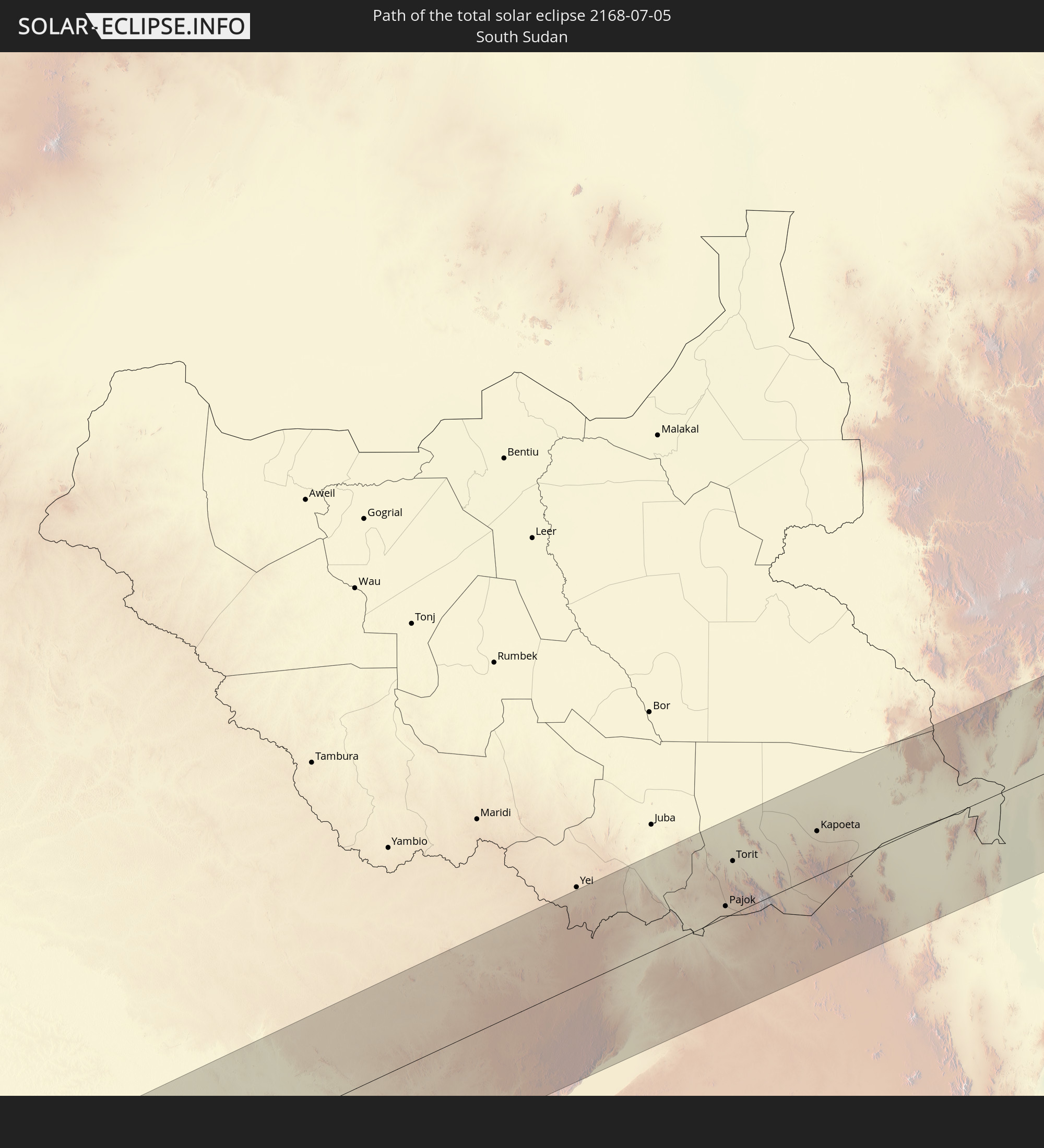 South Sudan
 Uganda
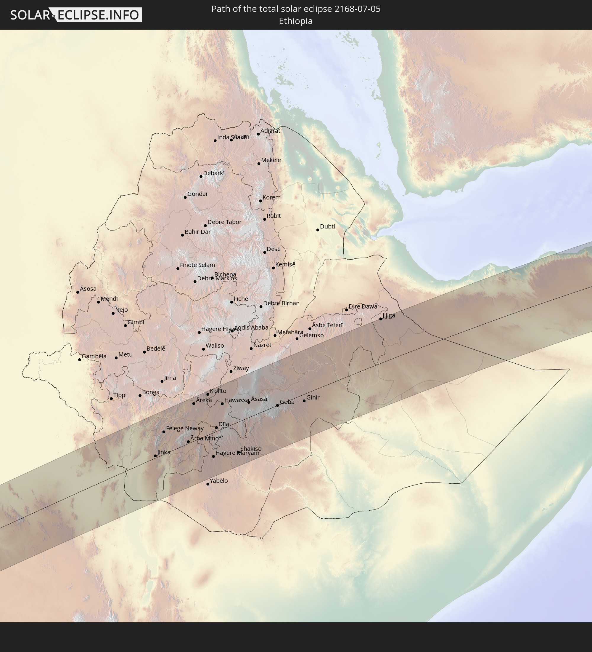 Ethiopia
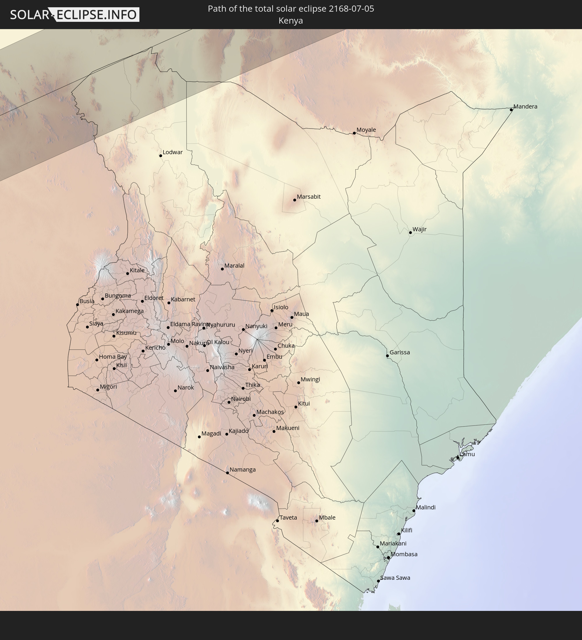 Kenya
Kenya
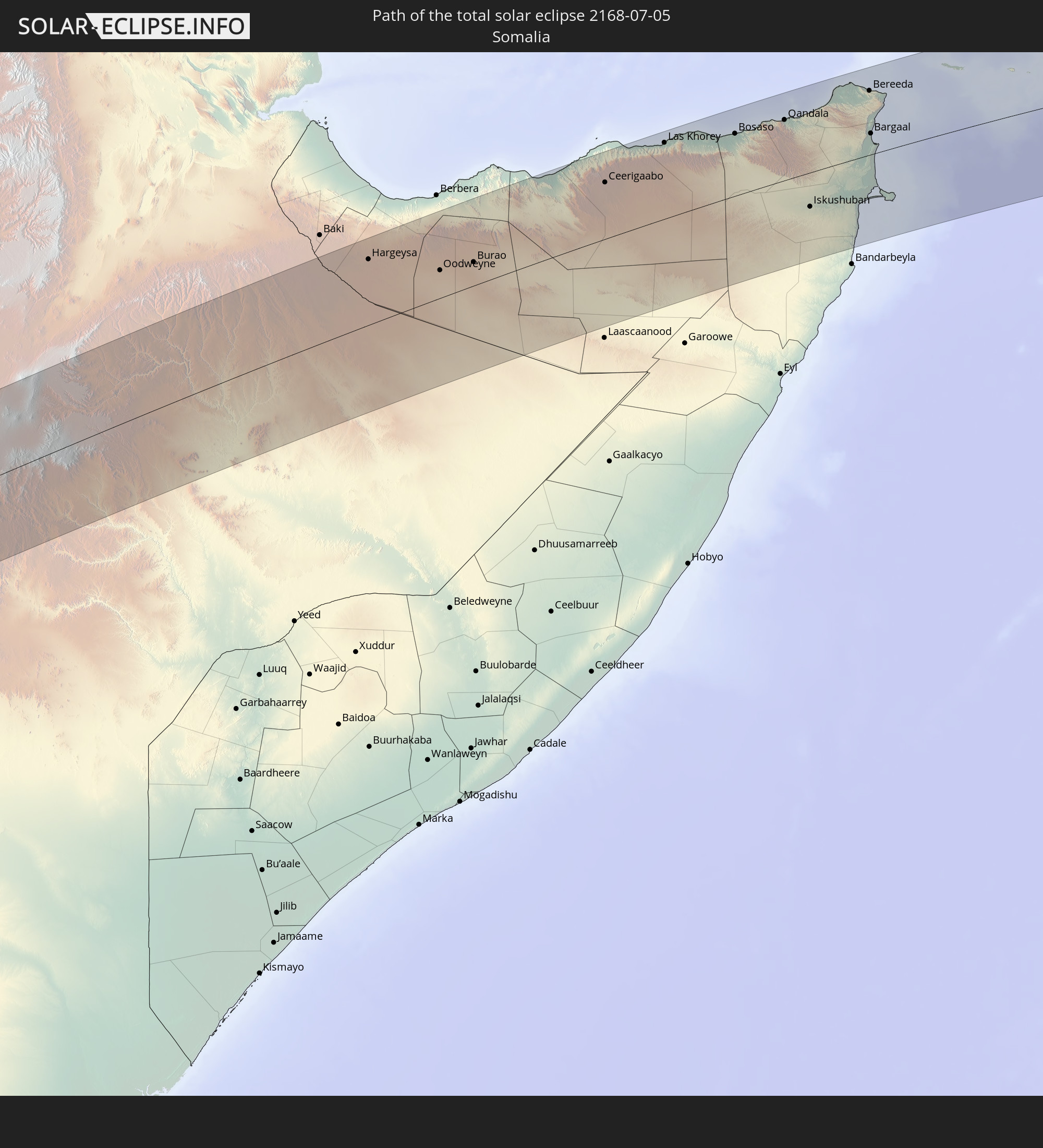 Somalia
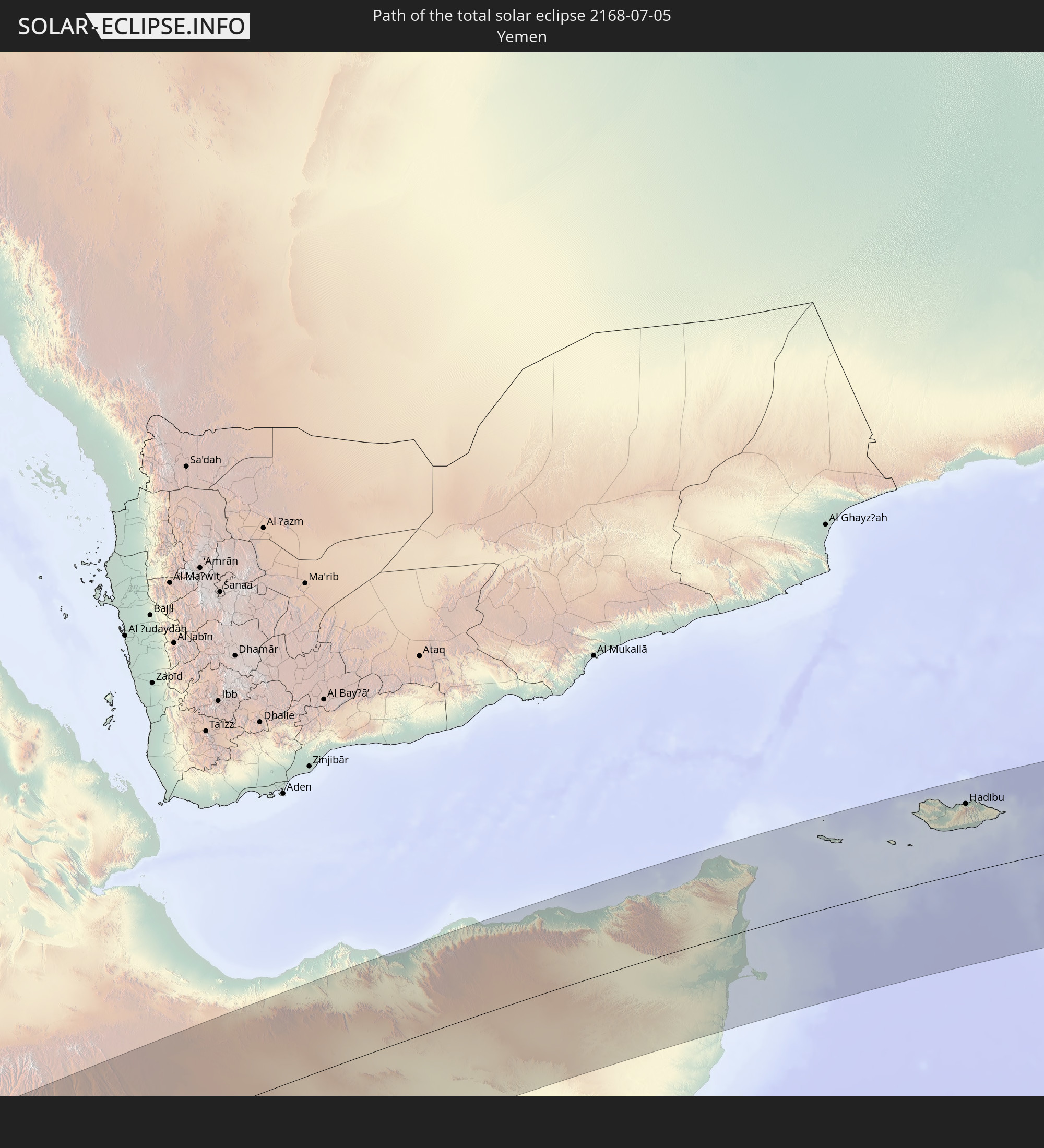 Yemen
Yemen
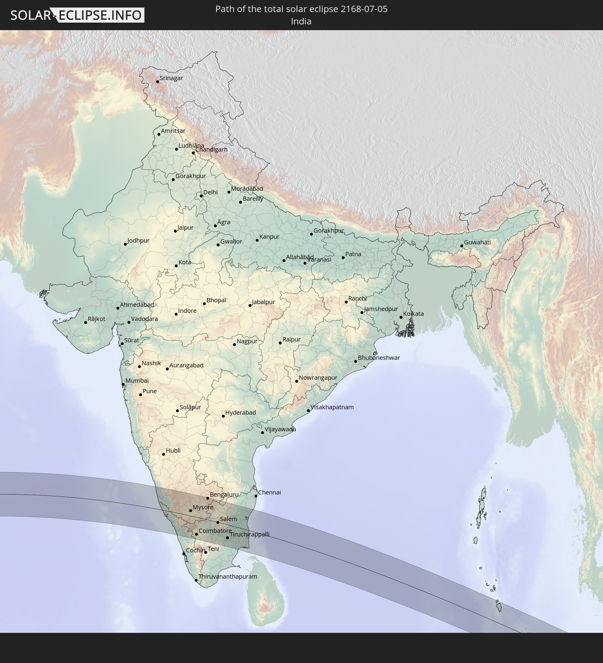 India
India
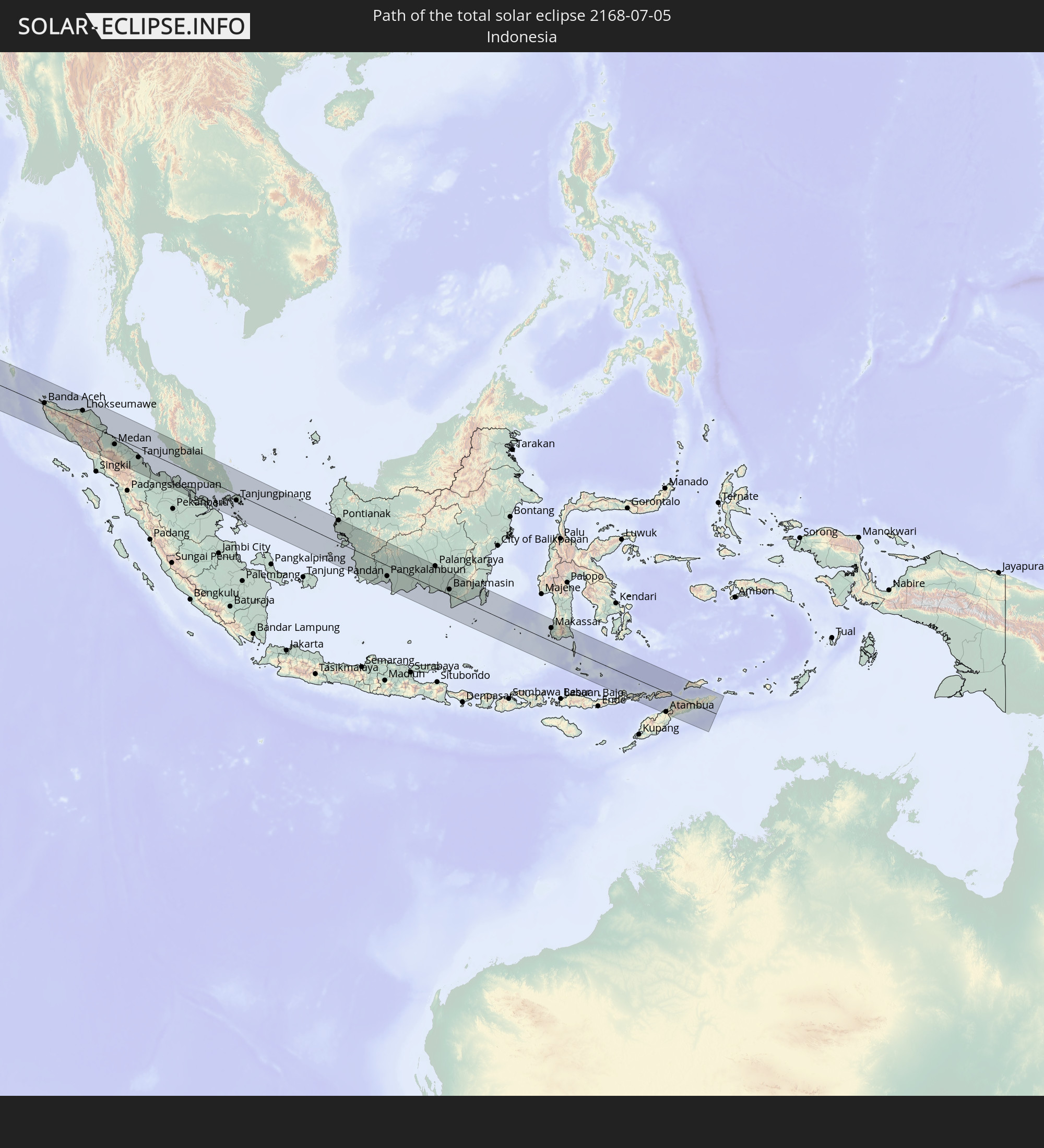 Indonesia
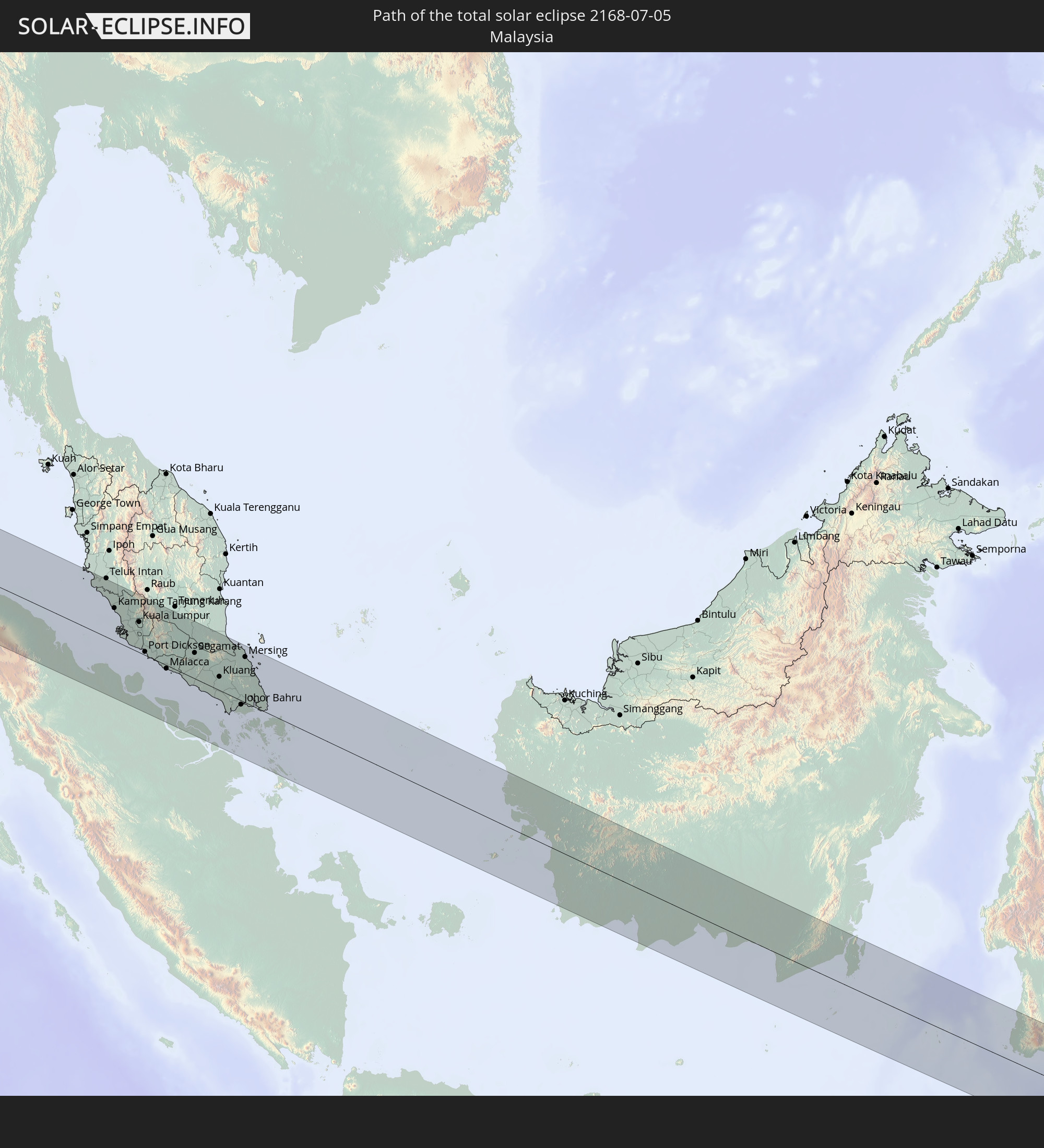 Malaysia
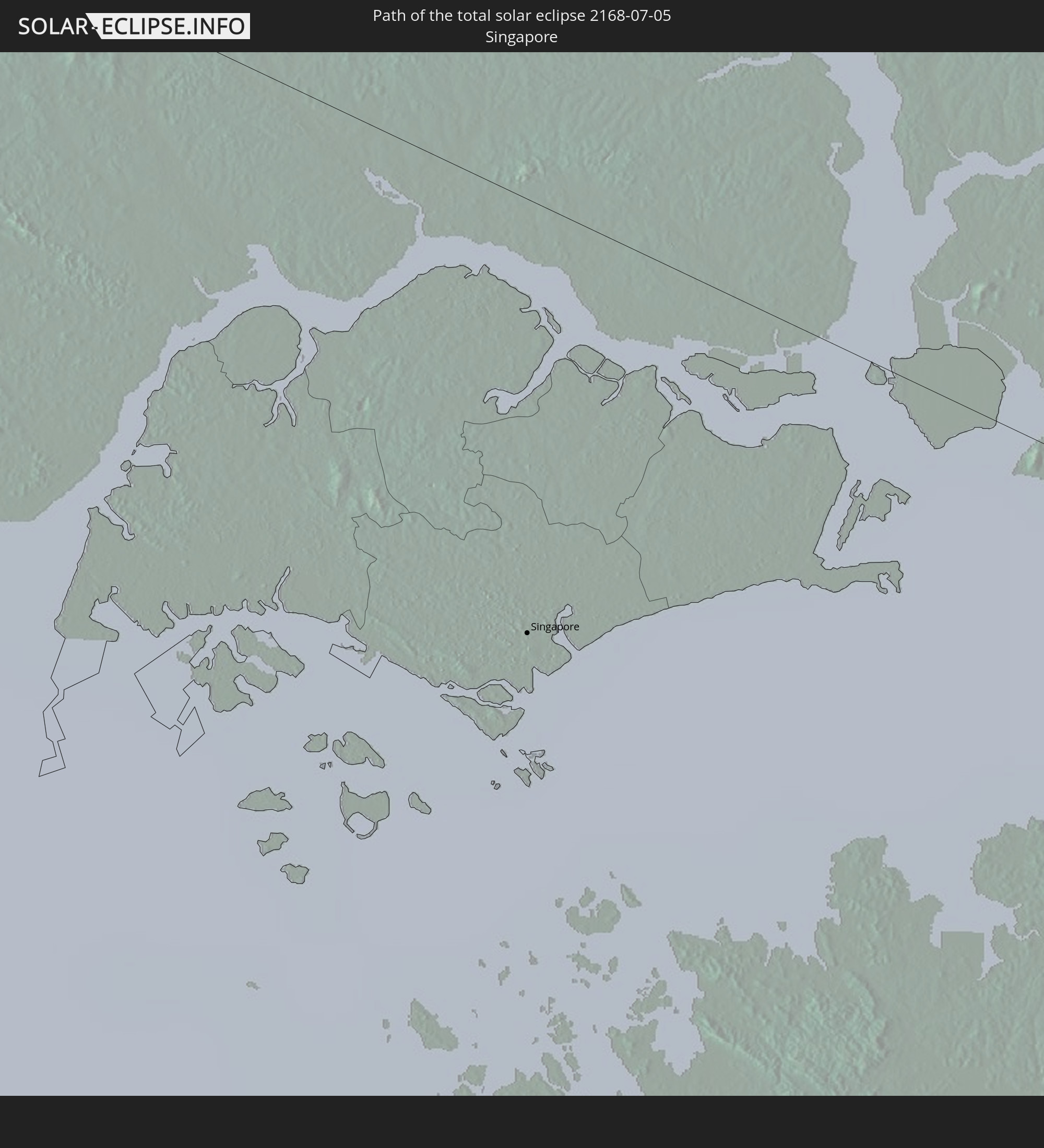 Singapore
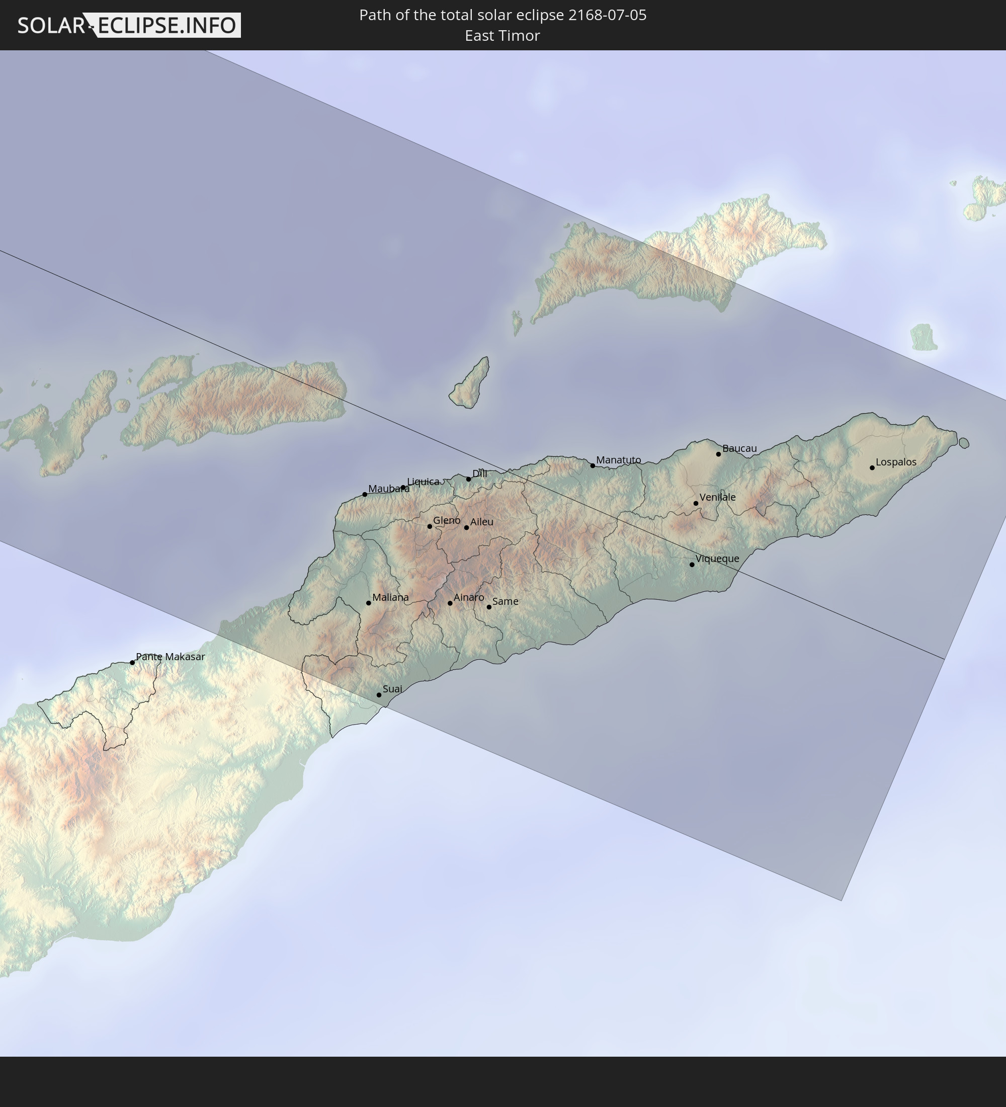 East Timor
In den folgenden Ländern ist die Sonnenfinsternis partiell zu sehen
 Russia
 Mauritania
 Mali
Mali
 Algeria
 Ivory Coast
 Burkina Faso
 Ghana
Ghana
 Togo
Togo
 Niger
Niger
 Benin
Benin
 Nigeria
 Equatorial Guinea
 São Tomé and Príncipe
 Cameroon
 Gabon
Gabon
 Libya
Libya
 Republic of the Congo
 Angola
 Namibia
 Democratic Republic of the Congo
 Chad
Chad
 Central African Republic
 South Africa
 Greece
 Botswana
 Sudan
Sudan
 Zambia
 Egypt
Egypt
 Zimbabwe
 Turkey
 Lesotho
 Rwanda
 Burundi
 Tanzania
 Uganda
 Mozambique
 Swaziland
 Cyprus
 Malawi
 Ethiopia
 Kenya
Kenya
 State of Palestine
 Israel
 Saudi Arabia
 Jordan
 Lebanon
 Syria
Syria
 Eritrea
 Iraq
Iraq
 Georgia
 French Southern and Antarctic Lands
 Somalia
 Djibouti
 Yemen
Yemen
 Madagascar
 Comoros
 Armenia
 Iran
Iran
 Azerbaijan
 Mayotte
 Seychelles
 Kazakhstan
 Kuwait
 Bahrain
 Qatar
Qatar
 United Arab Emirates
 Oman
Oman
 Turkmenistan
 Réunion
 Uzbekistan
 Mauritius
 Afghanistan
 Pakistan
 Tajikistan
 India
India
 Kyrgyzstan
 British Indian Ocean Territory
 Maldives
 China
China
 Sri Lanka
 Nepal
Nepal
 Bangladesh
 Bhutan
 Myanmar
 Indonesia
 Cocos Islands
 Thailand
 Malaysia
 Laos
Laos
 Vietnam
 Cambodia
 Singapore
 Christmas Island
 Australia
 Macau
Macau
 Hong Kong
 Brunei
 Taiwan
 Philippines
 Japan
Japan
 East Timor
 Palau
Palau
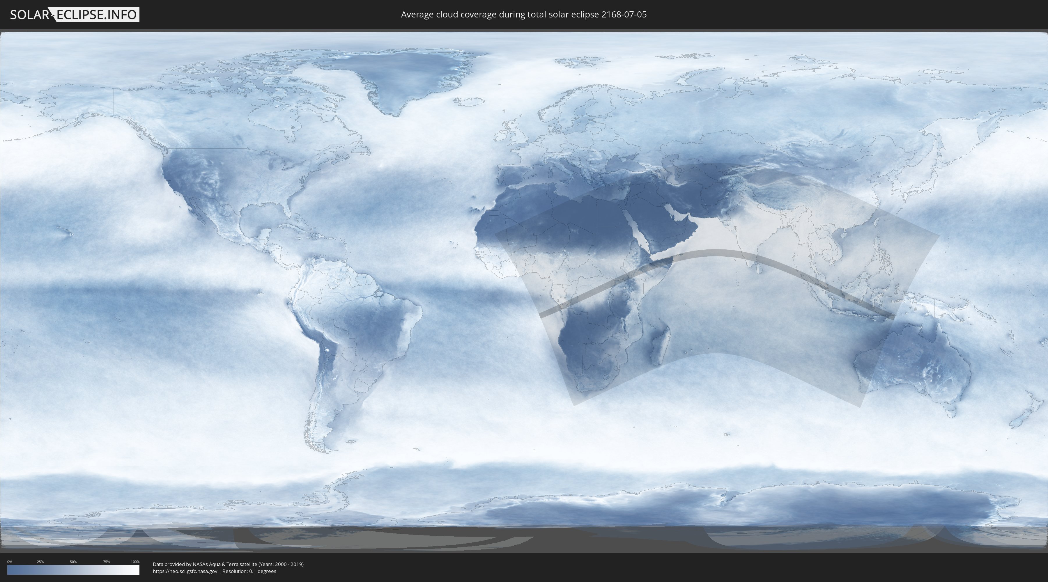
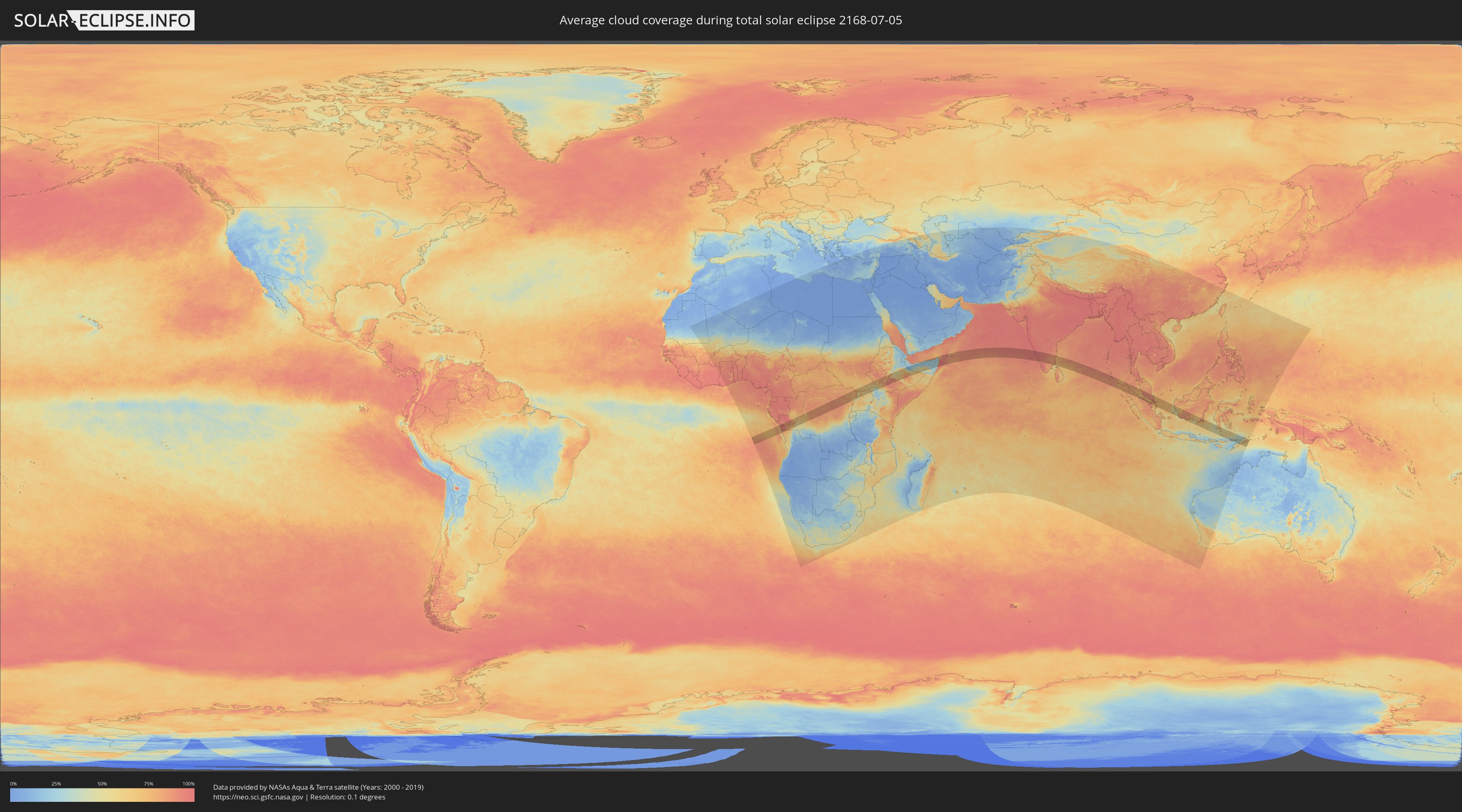
How will be the weather during the total solar eclipse on 07/05/2168?
Where is the best place to see the total solar eclipse of 07/05/2168?
The following maps show the average cloud coverage for the day of the total solar eclipse.
With the help of these maps, it is possible to find the place along the eclipse path, which has the best
chance of a cloudless sky.
Nevertheless, you should consider local circumstances and inform about the weather of your chosen
observation site.
The data is provided by NASAs satellites
AQUA and TERRA.
The cloud maps are averaged over a period of 19 years (2000 - 2019).
Detailed country maps
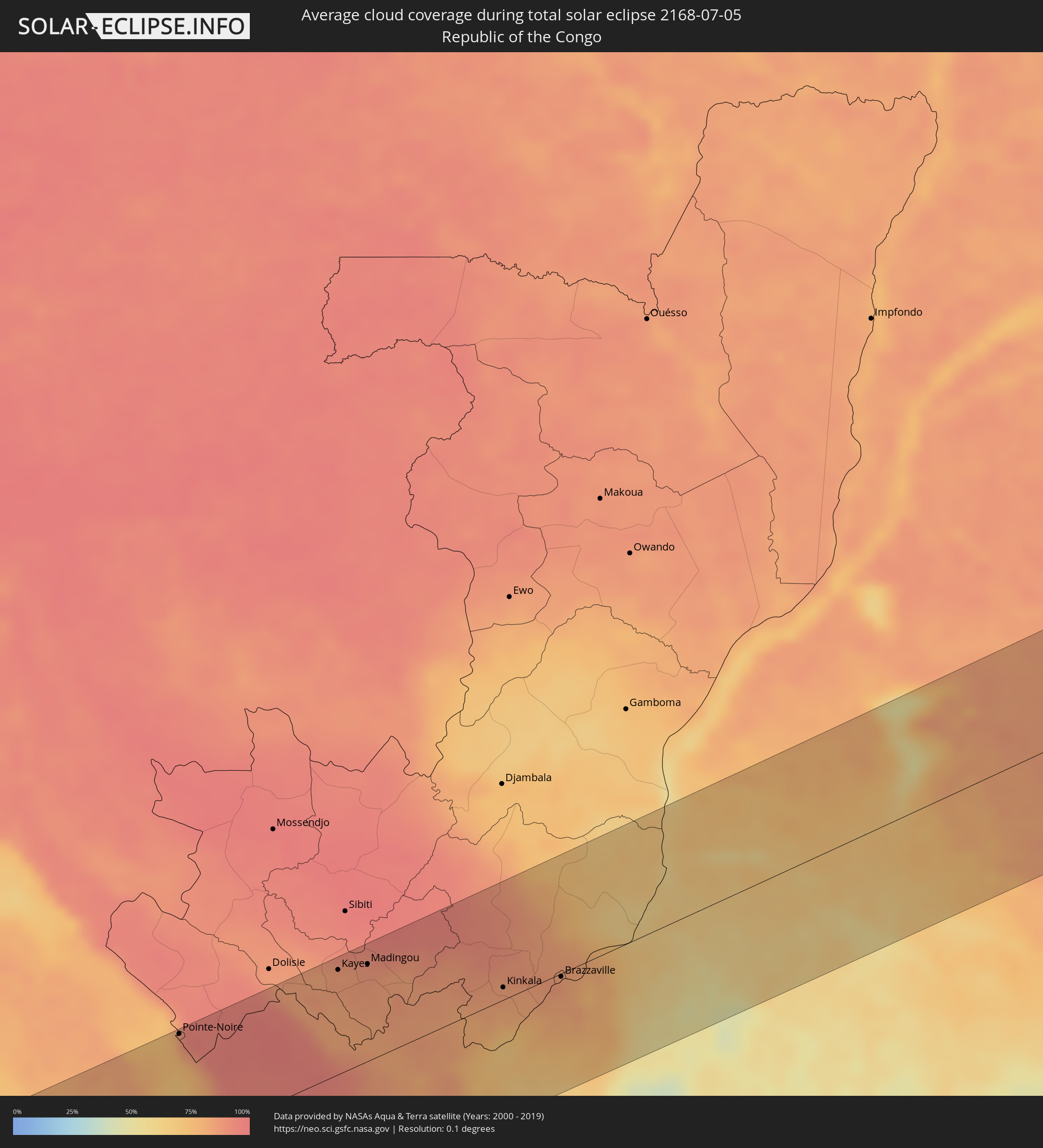 Republic of the Congo
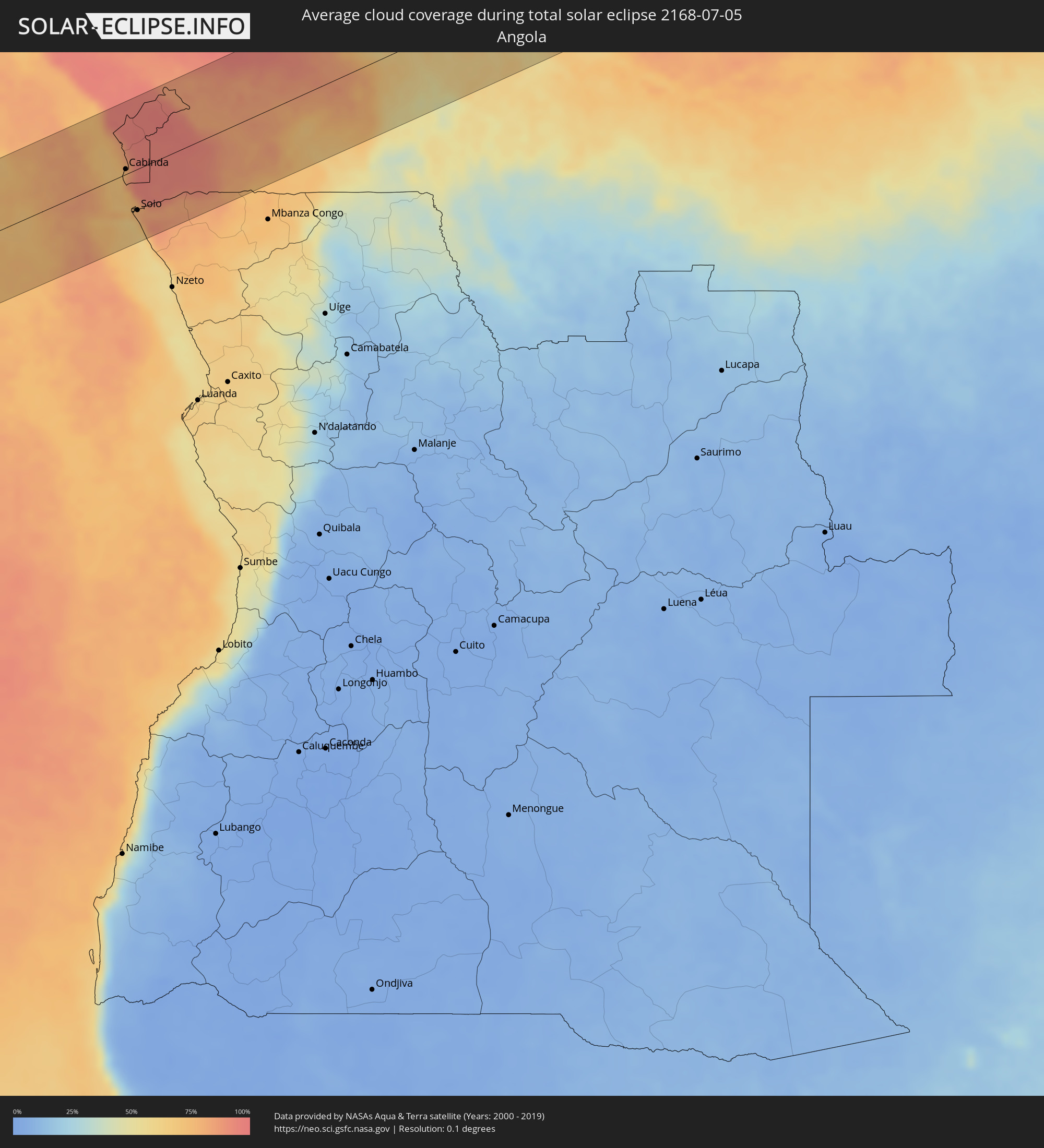 Angola
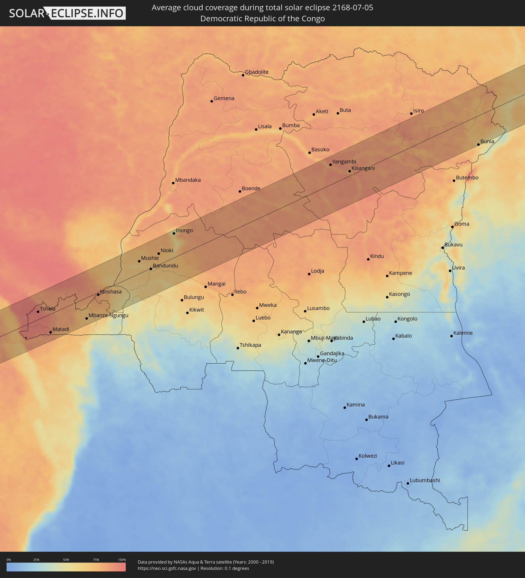 Democratic Republic of the Congo
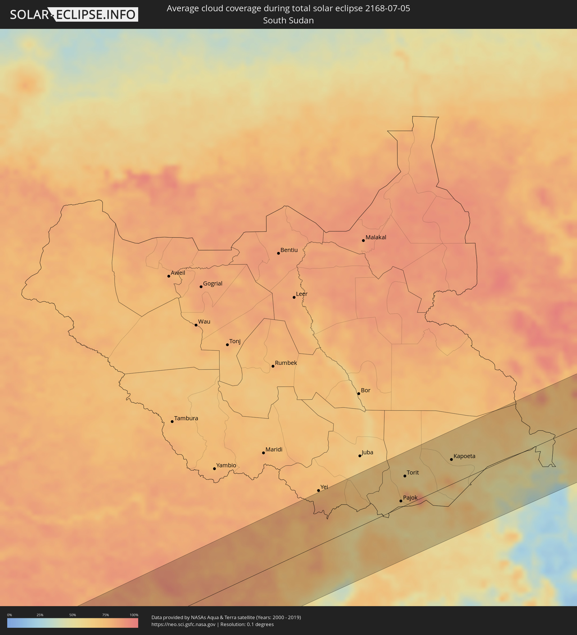 South Sudan
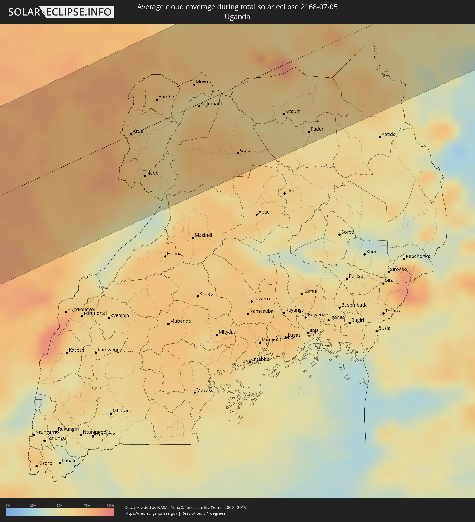 Uganda
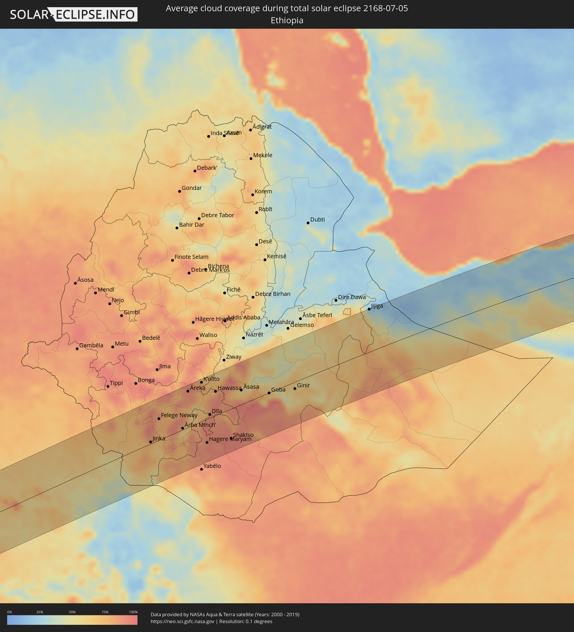 Ethiopia
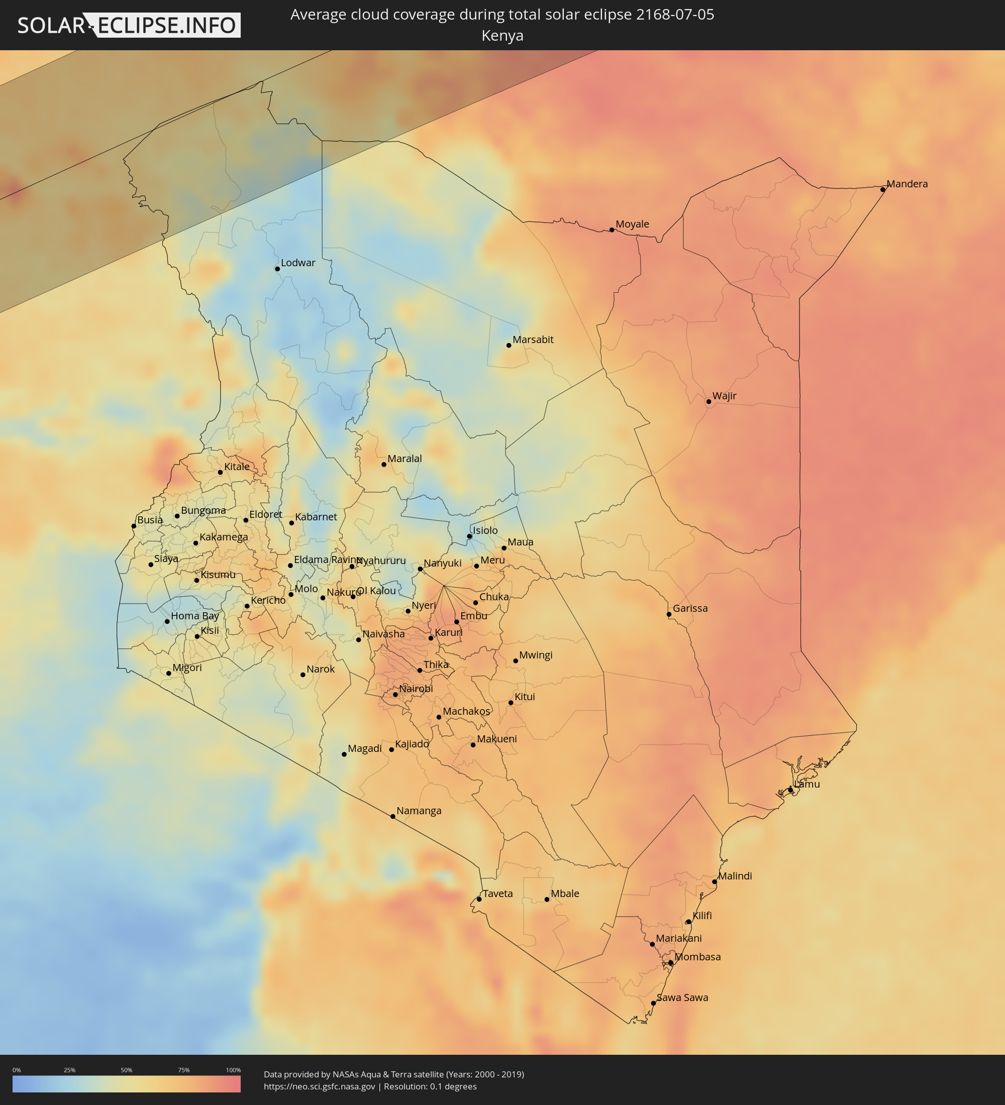 Kenya
Kenya
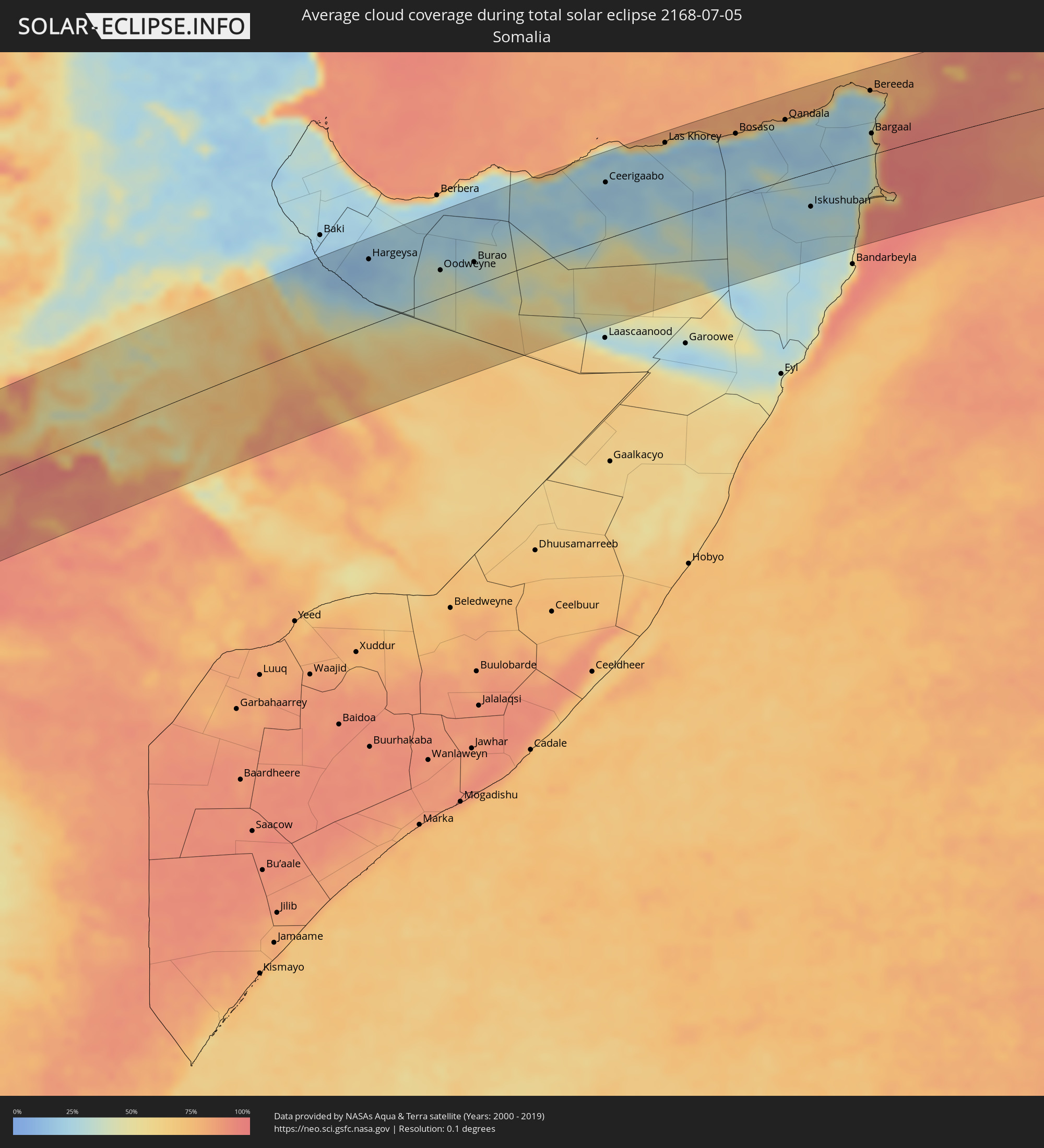 Somalia
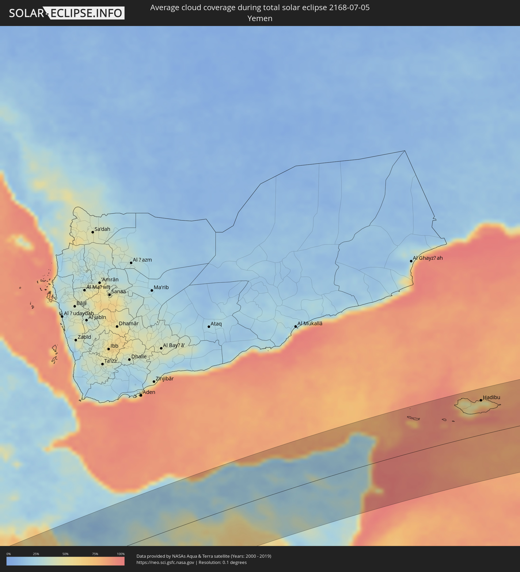 Yemen
Yemen
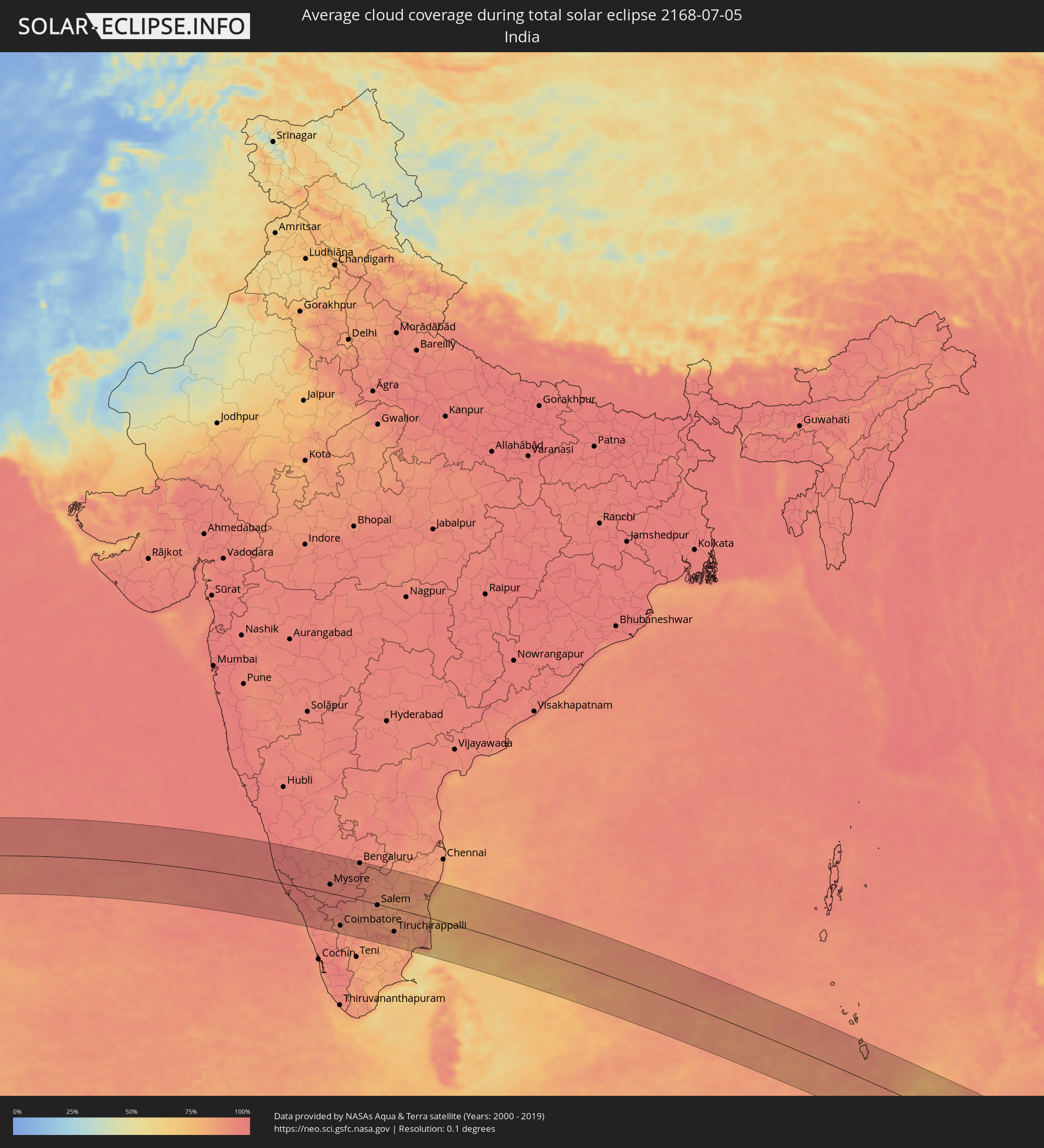 India
India
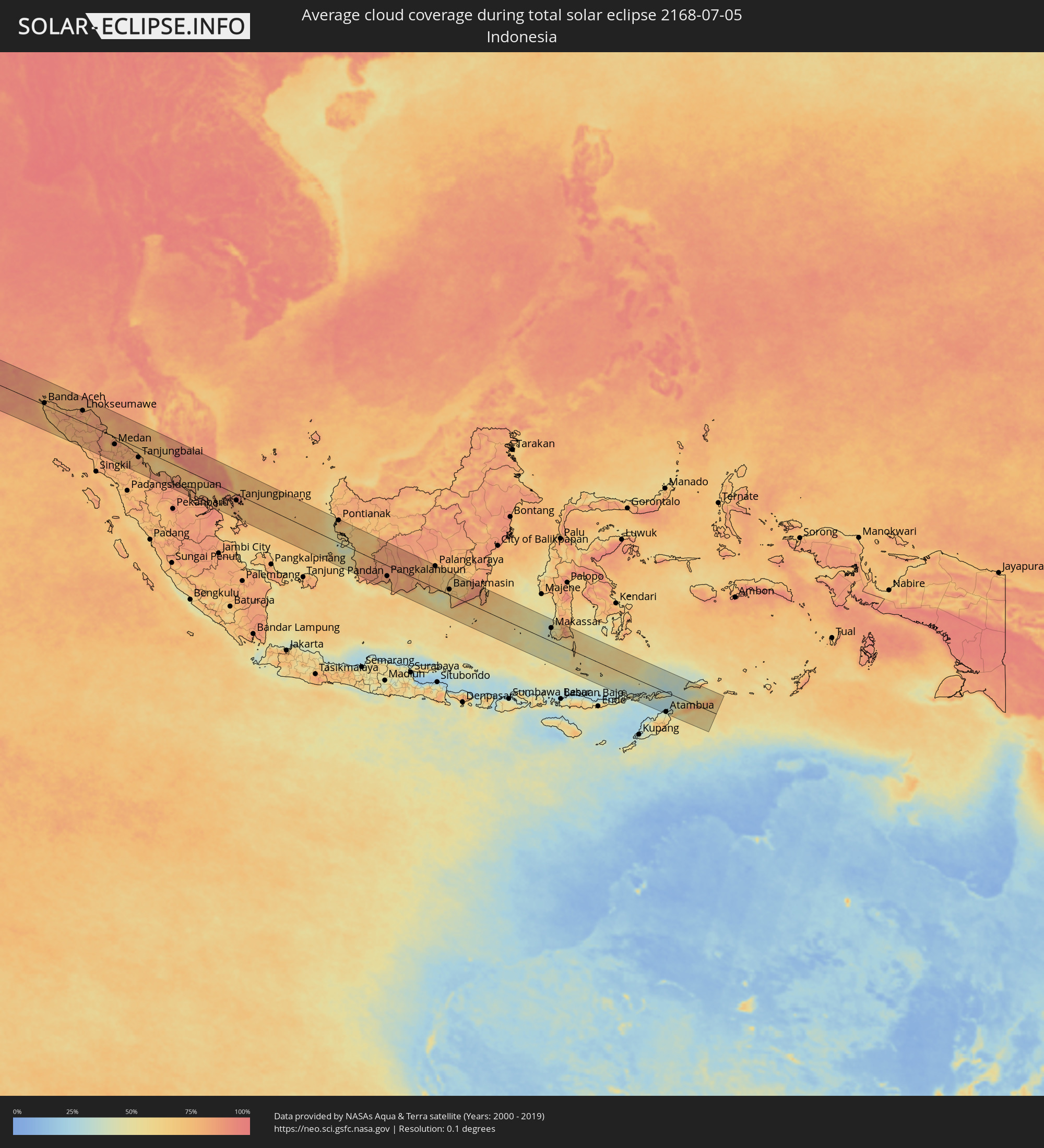 Indonesia
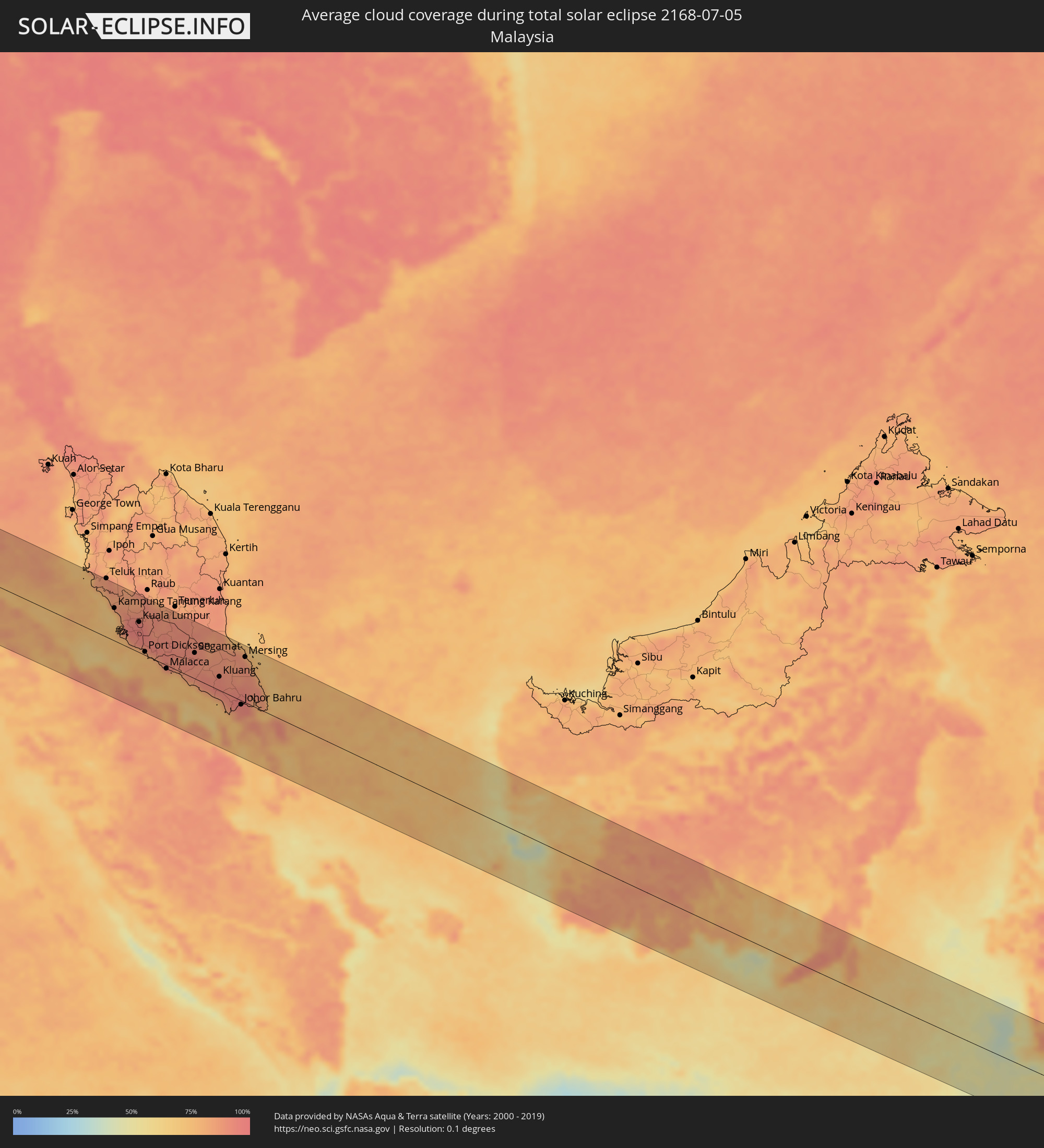 Malaysia
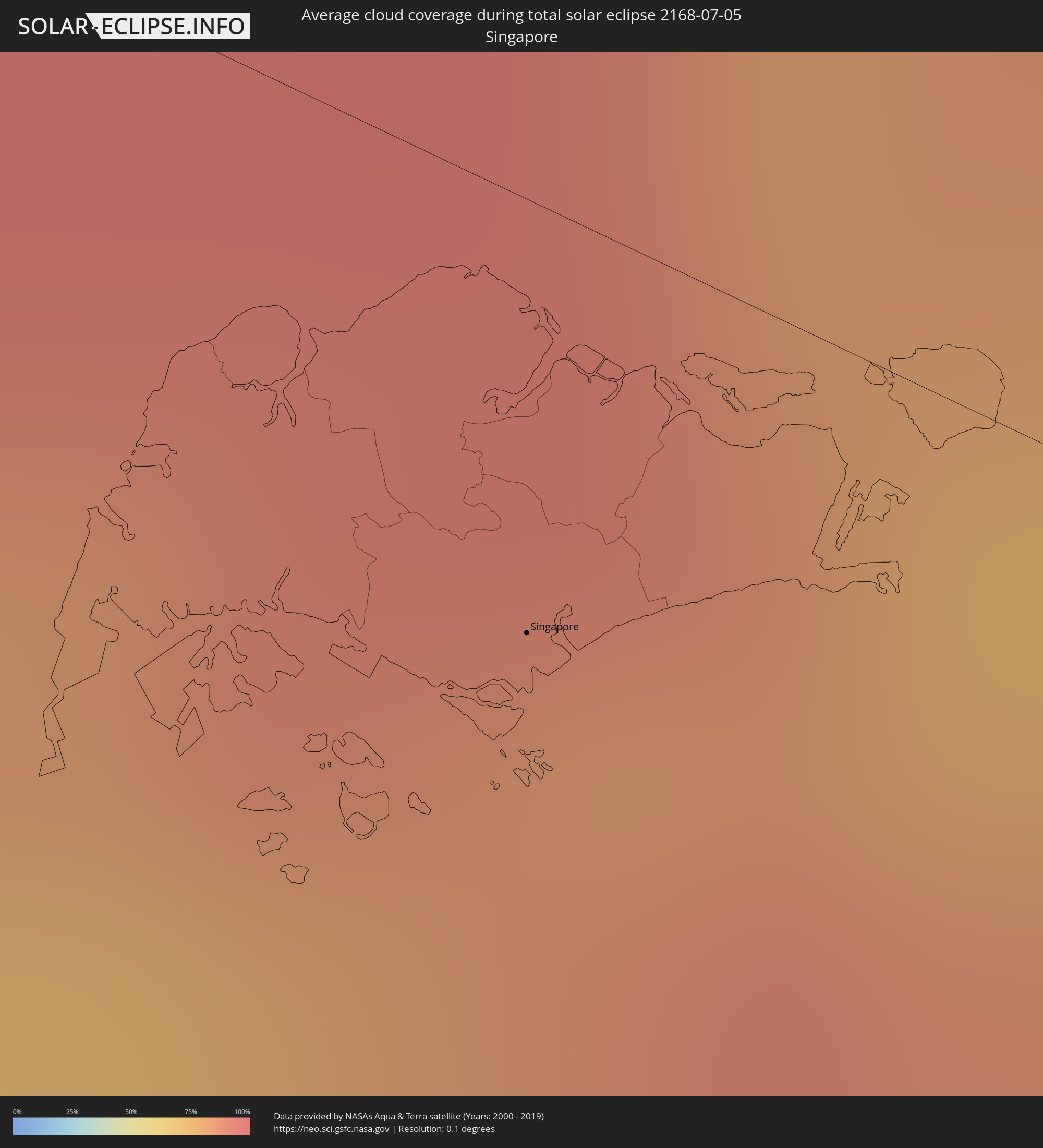 Singapore
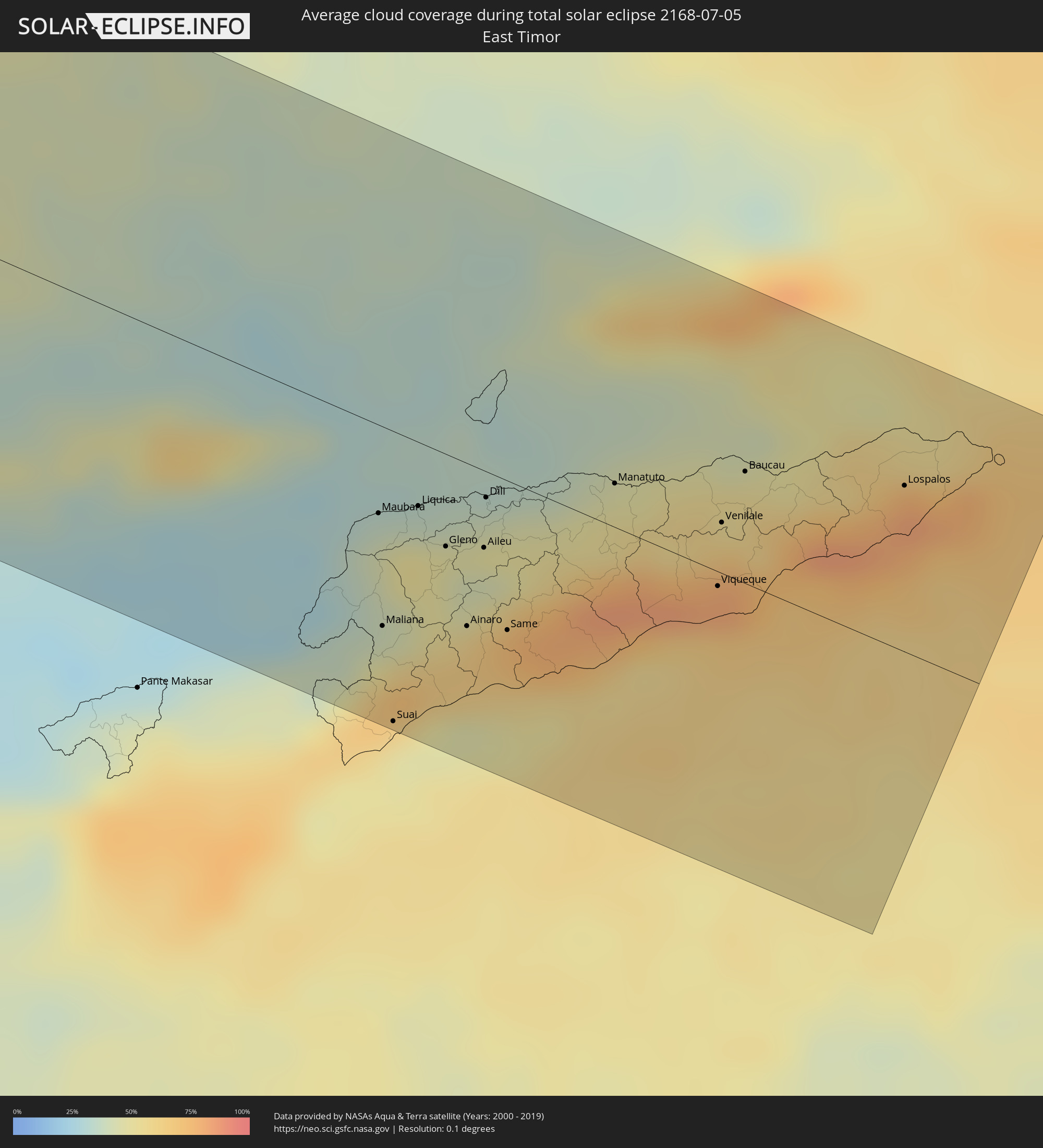 East Timor
Cities inside the path of the eclipse
The following table shows all locations with a population of more than 5,000 inside the eclipse path. Cities which have more than 100,000 inhabitants are marked bold. A click at the locations opens a detailed map.
| City | Type | Eclipse duration | Local time of max. eclipse | Distance to central line | Ø Cloud coverage |
|
Loandjili, Pointe-Noire
|
total | - | 06:58:56 UTC+01:00 | 104 km | 84% |
|
Pointe-Noire, Pointe-Noire
|
total | - | 06:58:56 UTC+01:00 | 101 km | 84% |
|
Cabinda, Cabinda
|
total | - | 06:58:54 UTC+01:00 | 7 km | 85% |
|
Soio, Zaire
|
total | - | 06:58:52 UTC+01:00 | 60 km | 81% |
|
Tshela, Bas-Congo
|
total | - | 06:59:09 UTC+01:00 | 30 km | 95% |
|
Kayes, Bouenza
|
total | - | 06:59:22 UTC+01:00 | 95 km | 86% |
|
Matadi, Bas-Congo
|
total | - | 06:59:10 UTC+01:00 | 74 km | 83% |
|
Madingou, Bouenza
|
total | - | 06:59:27 UTC+01:00 | 88 km | 85% |
|
Kinkala, Pool
|
total | - | 06:59:46 UTC+01:00 | 11 km | 81% |
|
Mbanza-Ngungu, Bas-Congo
|
total | - | 06:59:40 UTC+01:00 | 84 km | 72% |
|
Kasangulu, Bas-Congo
|
total | - | 06:59:52 UTC+01:00 | 30 km | 79% |
|
Brazzaville, Brazzaville
|
total | - | 06:59:58 UTC+01:00 | 3 km | 82% |
|
Kinshasa, Kinshasa
|
total | - | 06:59:58 UTC+01:00 | 11 km | 82% |
|
Masina, Kinshasa
|
total | - | 06:59:59 UTC+01:00 | 20 km | 82% |
|
Mushie, Bandundu
|
total | - | 07:00:50 UTC+01:00 | 48 km | 62% |
|
Bandundu, Bandundu
|
total | - | 07:00:57 UTC+01:00 | 4 km | 64% |
|
Nioki, Bandundu
|
total | - | 07:01:13 UTC+01:00 | 42 km | 72% |
|
Inongo, Bandundu
|
total | - | 07:01:42 UTC+01:00 | 95 km | 61% |
|
Yangambi, Orientale
|
total | - | 08:06:19 UTC+02:00 | 78 km | 81% |
|
Kisangani, Orientale
|
total | - | 08:06:48 UTC+02:00 | 17 km | 83% |
|
Wamba, Orientale
|
total | - | 08:09:55 UTC+02:00 | 49 km | 84% |
|
Watsa, Orientale
|
total | - | 08:11:51 UTC+02:00 | 67 km | 80% |
|
Bunia, Orientale
|
total | - | 08:11:55 UTC+02:00 | 116 km | 60% |
|
Arua, Northern Region
|
total | - | 09:13:19 UTC+03:00 | 1 km | 69% |
|
Paidha, Northern Region
|
total | - | 09:13:06 UTC+03:00 | 64 km | 68% |
|
Nebbi, Northern Region
|
total | - | 09:13:15 UTC+03:00 | 62 km | 65% |
|
Yumbe, Northern Region
|
total | - | 09:13:55 UTC+03:00 | 30 km | 69% |
|
Moyo, Northern Region
|
total | - | 09:14:33 UTC+03:00 | 28 km | 66% |
|
Adjumani, Northern Region
|
total | - | 09:14:29 UTC+03:00 | 4 km | 65% |
|
Gulu, Northern Region
|
total | - | 09:14:47 UTC+03:00 | 89 km | 70% |
 Pajok, Eastern Equatoria
|
total | - | 08:15:34 UTC+02:00 | 13 km | 65% |
|
Torit, Eastern Equatoria
|
total | - | 08:15:57 UTC+02:00 | 64 km | 61% |
|
Kitgum, Northern Region
|
total | - | 09:15:45 UTC+03:00 | 65 km | 57% |
|
Pader, Northern Region
|
total | - | 09:16:03 UTC+03:00 | 103 km | 54% |
|
Kapoeta, Eastern Equatoria
|
total | - | 08:17:26 UTC+02:00 | 54 km | 62% |
|
Jinka, Southern Nations, Nationalities, and People's Region
|
total | - | 09:22:08 UTC+03:00 | 5 km | 78% |
|
Felege Neway, Southern Nations, Nationalities, and People's Region
|
total | - | 09:22:52 UTC+03:00 | 61 km | 78% |
|
Ārba Minch’, Southern Nations, Nationalities, and People's Region
|
total | - | 09:23:43 UTC+03:00 | 4 km | 59% |
|
Āreka, Southern Nations, Nationalities, and People's Region
|
total | - | 09:24:35 UTC+03:00 | 103 km | 89% |
|
Bodītī, Southern Nations, Nationalities, and People's Region
|
total | - | 09:24:47 UTC+03:00 | 85 km | 86% |
|
K’olīto, Southern Nations, Nationalities, and People's Region
|
total | - | 09:25:20 UTC+03:00 | 111 km | 78% |
|
Dīla, Southern Nations, Nationalities, and People's Region
|
total | - | 09:25:09 UTC+03:00 | 9 km | 86% |
|
Yirga ‘Alem, Southern Nations, Nationalities, and People's Region
|
total | - | 09:25:30 UTC+03:00 | 39 km | 88% |
|
Hawassa, Southern Nations, Nationalities, and People's Region
|
total | - | 09:25:48 UTC+03:00 | 68 km | 79% |
|
Shashemenē, Oromiya
|
total | - | 09:26:05 UTC+03:00 | 77 km | 82% |
|
Shakīso, Oromiya
|
total | - | 09:25:43 UTC+03:00 | 85 km | 93% |
|
Kibre Mengist, Oromiya
|
total | - | 09:25:54 UTC+03:00 | 74 km | 90% |
|
Dodola, Oromiya
|
total | - | 09:26:54 UTC+03:00 | 30 km | 71% |
|
Āsasa, Oromiya
|
total | - | 09:27:00 UTC+03:00 | 41 km | 62% |
|
Goba, Oromiya
|
total | - | 09:28:16 UTC+03:00 | 1 km | 71% |
|
Jijiga, Somali
|
total | - | 09:34:51 UTC+03:00 | 122 km | 25% |
|
Hargeysa, Woqooyi Galbeed
|
total | - | 09:37:27 UTC+03:00 | 94 km | 16% |
|
Oodweyne, Togdheer
|
total | - | 09:39:23 UTC+03:00 | 40 km | 37% |
|
Burao, Togdheer
|
total | - | 09:40:26 UTC+03:00 | 34 km | 30% |
|
Ceerigaabo, Sanaag
|
total | - | 09:45:07 UTC+03:00 | 82 km | 19% |
|
Las Khorey, Sanaag
|
total | - | 09:47:20 UTC+03:00 | 110 km | 39% |
|
Bosaso, Bari
|
total | - | 09:49:41 UTC+03:00 | 91 km | 29% |
|
Qandala, Bari
|
total | - | 09:51:27 UTC+03:00 | 88 km | 31% |
|
Iskushuban, Bari
|
total | - | 09:51:36 UTC+03:00 | 50 km | 27% |
|
Bereeda, Bari
|
total | - | 09:54:35 UTC+03:00 | 94 km | 38% |
|
Bargaal, Bari
|
total | - | 09:54:17 UTC+03:00 | 31 km | 62% |
|
Hadibu, Soqatra Governorate
|
total | - | 10:02:37 UTC+03:00 | 96 km | 69% |
|
Udipi, Karnataka
|
total | - | 13:34:23 UTC+05:30 | 102 km | 95% |
|
Mangalore, Karnataka
|
total | - | 13:34:52 UTC+05:30 | 58 km | 95% |
|
Kozhikode, Kerala
|
total | - | 13:38:16 UTC+05:30 | 105 km | 87% |
|
Mysore, Karnataka
|
total | - | 13:40:12 UTC+05:30 | 29 km | 96% |
|
Mandya, Karnataka
|
total | - | 13:40:48 UTC+05:30 | 60 km | 94% |
|
Coimbatore, Tamil Nadu
|
total | - | 13:41:45 UTC+05:30 | 103 km | 87% |
|
Tiruppur, Tamil Nadu
|
total | - | 13:42:47 UTC+05:30 | 82 km | 88% |
|
Bengaluru, Karnataka
|
total | - | 13:42:29 UTC+05:30 | 125 km | 92% |
|
Erode, Tamil Nadu
|
total | - | 13:43:42 UTC+05:30 | 48 km | 88% |
|
Salem, Tamil Nadu
|
total | - | 13:44:43 UTC+05:30 | 3 km | 86% |
|
Tiruchirappalli, Tamil Nadu
|
total | - | 13:46:37 UTC+05:30 | 79 km | 87% |
|
Tiruvannāmalai, Tamil Nadu
|
total | - | 13:46:51 UTC+05:30 | 84 km | 86% |
|
Thanjāvūr, Tamil Nadu
|
total | - | 13:47:50 UTC+05:30 | 70 km | 86% |
|
Kumbakonam, Tamil Nadu
|
total | - | 13:48:24 UTC+05:30 | 44 km | 85% |
|
Cuddalore, Tamil Nadu
|
total | - | 13:48:55 UTC+05:30 | 51 km | 79% |
|
Puducherry, Pondicherry
|
total | - | 13:48:59 UTC+05:30 | 73 km | 81% |
|
Banda Aceh, Aceh
|
total | - | 15:55:07 UTC+07:00 | 9 km | 74% |
|
Binjai, North Sumatra
|
total | - | 16:00:41 UTC+07:00 | 42 km | 81% |
|
Medan, North Sumatra
|
total | - | 16:00:56 UTC+07:00 | 35 km | 88% |
|
Belawan, North Sumatra
|
total | - | 16:00:51 UTC+07:00 | 15 km | 82% |
|
Percut, North Sumatra
|
total | - | 16:01:10 UTC+07:00 | 22 km | 83% |
|
Pematangsiantar, North Sumatra
|
total | - | 16:01:47 UTC+07:00 | 80 km | 83% |
|
Tebingtinggi, North Sumatra
|
total | - | 16:01:42 UTC+07:00 | 38 km | 80% |
|
Kisaran, North Sumatra
|
total | - | 16:02:27 UTC+07:00 | 51 km | 80% |
|
Tanjungbalai, North Sumatra
|
total | - | 16:02:41 UTC+07:00 | 45 km | 81% |
|
Dumai, Riau
|
total | - | 16:05:16 UTC+07:00 | 98 km | 90% |
|
Klang, Selangor
|
total | - | 17:04:35 UTC+08:00 | 40 km | 94% |
|
Kampung Baru Subang, Selangor
|
total | - | 17:04:37 UTC+08:00 | 56 km | 95% |
|
Rawang, Selangor
|
total | - | 17:04:35 UTC+08:00 | 75 km | 93% |
|
Kuala Lumpur, Kuala Lumpur
|
total | - | 17:04:48 UTC+08:00 | 62 km | 96% |
|
Sepang, Selangor
|
total | - | 17:05:06 UTC+08:00 | 20 km | 81% |
|
Port Dickson, Negeri Sembilan
|
total | - | 17:05:14 UTC+08:00 | 7 km | 73% |
|
Semenyih, Selangor
|
total | - | 17:05:04 UTC+08:00 | 50 km | 96% |
|
Seremban, Negeri Sembilan
|
total | - | 17:05:17 UTC+08:00 | 33 km | 93% |
|
Malacca, Melaka
|
total | - | 17:05:53 UTC+08:00 | 7 km | 78% |
|
Muar, Johor
|
total | - | 17:06:18 UTC+08:00 | 7 km | 74% |
|
Segamat, Johor
|
total | - | 17:06:20 UTC+08:00 | 53 km | 91% |
|
Batu Pahat, Johor
|
total | - | 17:06:46 UTC+08:00 | 8 km | 84% |
|
Kluang, Johor
|
total | - | 17:07:05 UTC+08:00 | 28 km | 92% |
|
Taman Senai, Johor
|
total | - | 17:07:37 UTC+08:00 | 0 km | 95% |
|
Johor Bahru, Johor
|
total | - | 17:07:47 UTC+08:00 | 8 km | 94% |
|
Ulu Tiram, Johor
|
total | - | 17:07:47 UTC+08:00 | 8 km | 96% |
|
Singapore, Central Singapore
|
total | - | 17:07:58 UTC+08:00 | 22 km | 83% |
|
Tanjungpinang, Riau Islands
|
total | - | 16:08:43 UTC+07:00 | 30 km | 84% |
|
Pontianak, West Kalimantan
|
total | - | 16:13:05 UTC+07:00 | 107 km | 82% |
|
Palangkaraya, Central Kalimantan
|
total | - | 16:16:30 UTC+07:00 | 105 km | 80% |
|
Banjarmasin, South Kalimantan
|
total | - | 17:17:07 UTC+08:00 | 24 km | 67% |
|
Martapura, South Kalimantan
|
total | - | 17:17:16 UTC+08:00 | 28 km | 68% |
|
Makassar, South Sulawesi
|
total | - | 17:19:12 UTC+08:00 | 63 km | 48% |
|
Maubara, Liquiçá
|
total | - | 18:20:27 UTC+09:00 | 31 km | 42% |
|
Maliana, Bobonaro
|
total | - | 18:20:27 UTC+09:00 | 69 km | 49% |
|
Suai, Cova Lima
|
total | - | 18:20:28 UTC+09:00 | 100 km | 47% |
|
Liquica, Liquiçá
|
total | - | 18:20:27 UTC+09:00 | 22 km | 49% |
|
Gleno, Ermera District
|
total | - | 18:20:28 UTC+09:00 | 32 km | 49% |
|
Ainaro, Ainaro
|
total | - | 18:20:28 UTC+09:00 | 56 km | 64% |
|
Aileu, Aileu
|
total | - | 18:20:28 UTC+09:00 | 27 km | 43% |
|
Dili, Díli
|
total | - | 18:20:28 UTC+09:00 | 9 km | 49% |
|
Same, Manufahi
|
total | - | 18:20:29 UTC+09:00 | 51 km | 67% |
|
Manatuto, Manatuto
|
total | - | 18:20:29 UTC+09:00 | 15 km | 52% |
|
Viqueque, Viqueque
|
total | - | 18:20:30 UTC+09:00 | 5 km | 67% |
|
Venilale, Baucau
|
total | - | 18:20:30 UTC+09:00 | 17 km | 66% |
|
Baucau, Baucau
|
total | - | 18:20:29 UTC+09:00 | 39 km | 61% |
|
Lospalos, Lautém
|
total | - | 18:20:30 UTC+09:00 | 57 km | 83% |