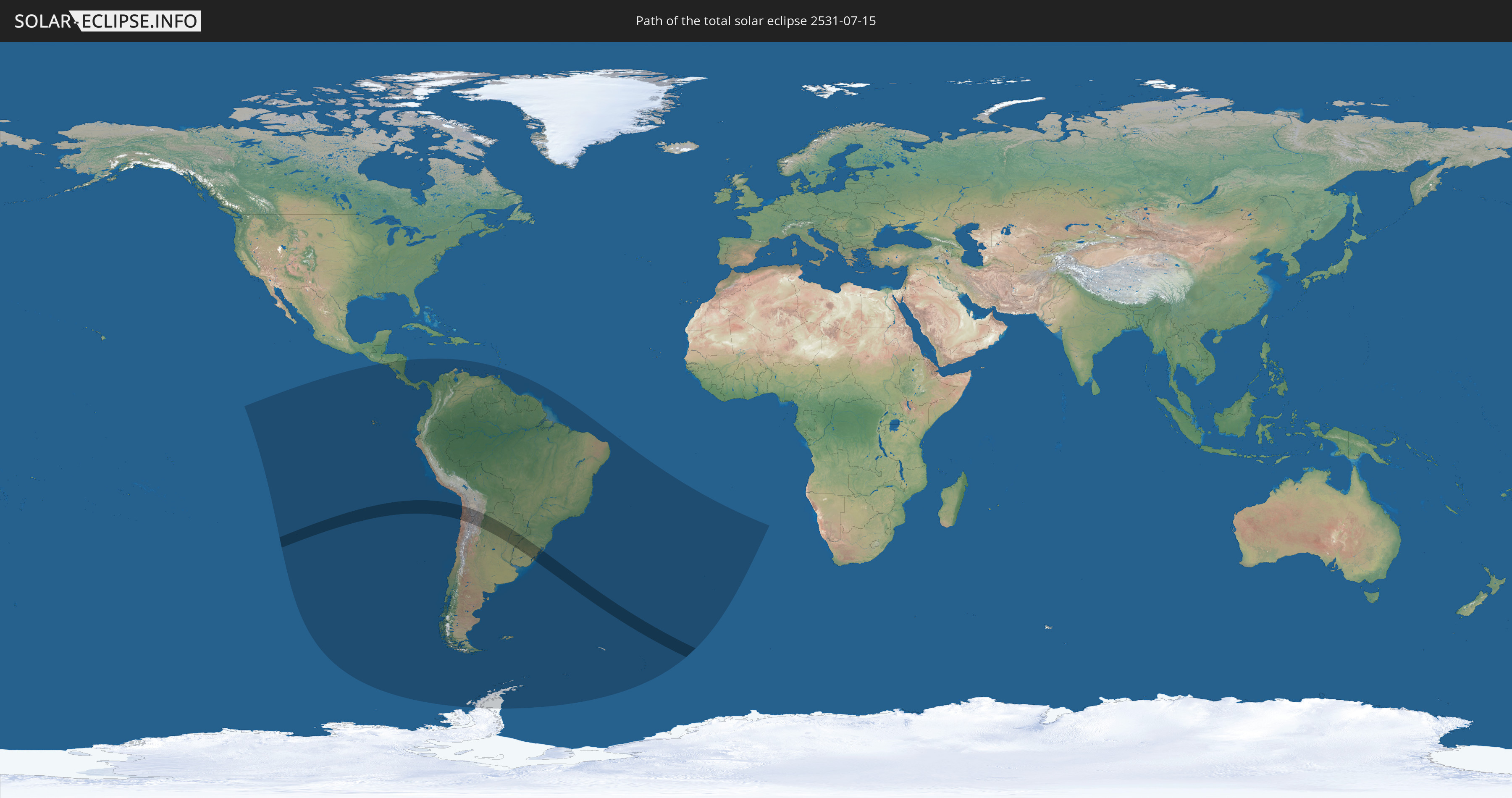
Total solar eclipse of 07/15/2531
| Day of week: | Sunday |
| Maximum duration of eclipse: | 06m25s |
| Maximum width of eclipse path: | 351 km |
| Saros cycle: | 164 |
| Coverage: | 100% |
| Magnitude: | 1.075 |
| Gamma: | -0.7256 |
Wo kann man die Sonnenfinsternis vom 07/15/2531 sehen?
Die Sonnenfinsternis am 07/15/2531 kann man in 25 Ländern als partielle Sonnenfinsternis beobachten.
Der Finsternispfad verläuft durch 6 Länder. Nur in diesen Ländern ist sie als total Sonnenfinsternis zu sehen.
In den folgenden Ländern ist die Sonnenfinsternis total zu sehen
 Chile
Chile
 Brazil
 Argentina
 Bolivia
 Paraguay
 Uruguay
In den folgenden Ländern ist die Sonnenfinsternis partiell zu sehen
 Antarctica
 Chile
Chile
 Ecuador
 El Salvador
 Honduras
 Nicaragua
 Costa Rica
 Panama
 Colombia
 Peru
Peru
 Brazil
 Argentina
 Venezuela
 Aruba
Aruba
 Bolivia
 Paraguay
 Trinidad and Tobago
 Grenada
 Falkland Islands
 Guyana
 Uruguay
 Suriname
 French Guiana
 South Georgia and the South Sandwich Islands
 Saint Helena, Ascension and Tristan da Cunha
How will be the weather during the total solar eclipse on 07/15/2531?
Where is the best place to see the total solar eclipse of 07/15/2531?
The following maps show the average cloud coverage for the day of the total solar eclipse.
With the help of these maps, it is possible to find the place along the eclipse path, which has the best
chance of a cloudless sky.
Nevertheless, you should consider local circumstances and inform about the weather of your chosen
observation site.
The data is provided by NASAs satellites
AQUA and TERRA.
The cloud maps are averaged over a period of 19 years (2000 - 2019).


Detailed country maps
 Chile
Chile
 Brazil
 Argentina
 Bolivia
 Paraguay
 Uruguay
Cities inside the path of the eclipse
The following table shows all locations with a population of more than 5,000 inside the eclipse path. Cities which have more than 100,000 inhabitants are marked bold. A click at the locations opens a detailed map.
| City | Type | Eclipse duration | Local time of max. eclipse | Distance to central line | Ø Cloud coverage |
|
Antofagasta, Antofagasta
|
total | - | 12:28:25 UTC-03:00 | 175 km | 26% |
|
Tocopilla, Antofagasta
|
total | - | 12:27:12 UTC-03:00 | 4 km | 44% |
|
Calama, Antofagasta
|
total | - | 12:30:49 UTC-03:00 | 0 km | 8% |
|
Villazón, Potosí
|
total | - | 11:38:51 UTC-04:00 | 168 km | 7% |
|
La Quiaca, Jujuy Province
|
total | - | 12:38:52 UTC-03:00 | 167 km | 7% |
|
Salta, Salta Province
|
total | - | 12:42:04 UTC-03:00 | 95 km | 40% |
|
San Salvador de Jujuy, Jujuy Province
|
total | - | 12:41:46 UTC-03:00 | 31 km | 42% |
|
San Pedro, Jujuy Province
|
total | - | 12:42:53 UTC-03:00 | 14 km | 50% |
|
Fraile Pintado, Jujuy Province
|
total | - | 12:42:46 UTC-03:00 | 17 km | 52% |
|
Libertador General San Martín, Jujuy Province
|
total | - | 12:42:39 UTC-03:00 | 31 km | 55% |
|
San Ramón de la Nueva Orán, Salta Province
|
total | - | 12:43:09 UTC-03:00 | 119 km | 59% |
|
Joaquín V. González, Salta Province
|
total | - | 12:45:25 UTC-03:00 | 66 km | 50% |
|
Embarcación, Salta Province
|
total | - | 12:43:47 UTC-03:00 | 122 km | 59% |
|
Charata, Chaco Province
|
total | - | 12:54:41 UTC-03:00 | 115 km | 54% |
|
Las Breñas, Chaco Province
|
total | - | 12:54:50 UTC-03:00 | 97 km | 50% |
|
Villa Ángela, Chaco Province
|
total | - | 12:56:06 UTC-03:00 | 122 km | 54% |
|
Castelli, Chaco Province
|
total | - | 12:54:56 UTC-03:00 | 35 km | 54% |
|
Presidencia Roque Sáenz Peña, Chaco Province
|
total | - | 12:56:06 UTC-03:00 | 34 km | 51% |
|
Tres Isletas, Chaco Province
|
total | - | 12:55:44 UTC-03:00 | 8 km | 50% |
|
Villa Berthet, Chaco Province
|
total | - | 12:56:35 UTC-03:00 | 79 km | 46% |
|
Quitilipi, Chaco Province
|
total | - | 12:56:42 UTC-03:00 | 29 km | 48% |
|
Machagai, Chaco Province
|
total | - | 12:57:08 UTC-03:00 | 25 km | 47% |
|
Presidencia de la Plaza, Chaco Province
|
total | - | 12:57:41 UTC-03:00 | 21 km | 45% |
|
El Colorado, Formosa Province
|
total | - | 12:58:13 UTC-03:00 | 69 km | 53% |
|
Villa Ocampo, Santa Fe Province
|
total | - | 13:00:02 UTC-03:00 | 129 km | 50% |
|
General José de San Martín, Chaco Province
|
total | - | 12:58:29 UTC-03:00 | 50 km | 52% |
|
Las Toscas, Santa Fe Province
|
total | - | 13:00:09 UTC-03:00 | 111 km | 50% |
|
Pirané, Formosa Province
|
total | - | 12:58:21 UTC-03:00 | 137 km | 49% |
|
Santa Lucía, Corrientes Province
|
total | - | 13:01:00 UTC-03:00 | 160 km | 48% |
|
Resistencia, Chaco Province
|
total | - | 13:00:04 UTC-03:00 | 15 km | 48% |
|
San Lorenzo, Corrientes Province
|
total | - | 13:01:06 UTC-03:00 | 63 km | 49% |
|
Saladas, Corrientes Province
|
total | - | 13:01:32 UTC-03:00 | 66 km | 52% |
|
San Luis del Palmar, Corrientes Province
|
total | - | 13:01:06 UTC-03:00 | 5 km | 49% |
|
Pilar, Ñeembucú
|
total | - | 13:01:12 UTC-03:00 | 79 km | 49% |
|
Formosa, Formosa Province
|
total | - | 13:00:54 UTC-03:00 | 148 km | 52% |
|
Mercedes, Corrientes Province
|
total | - | 13:03:29 UTC-03:00 | 118 km | 54% |
|
San Juan Bautista, Misiones
|
total | - | 13:03:41 UTC-03:00 | 162 km | 56% |
|
Uruguaiana, Rio Grande do Sul
|
total | - | 13:06:05 UTC-03:00 | 110 km | 61% |
|
Paso de los Libres, Corrientes Province
|
total | - | 13:06:03 UTC-03:00 | 106 km | 58% |
|
Ayolas, Misiones
|
total | - | 13:04:48 UTC-03:00 | 111 km | 49% |
|
Santa Rosa, Misiones
|
total | - | 13:04:31 UTC-03:00 | 162 km | 58% |
|
Itaqui, Rio Grande do Sul
|
total | - | 13:06:50 UTC-03:00 | 23 km | 56% |
|
Artigas, Artigas
|
total | - | 13:07:52 UTC-03:00 | 130 km | 58% |
|
Quaraí, Rio Grande do Sul
|
total | - | 13:07:54 UTC-03:00 | 128 km | 58% |
|
Santo Tomé, Corrientes Province
|
total | - | 13:07:34 UTC-03:00 | 58 km | 55% |
|
Gobernador Ingeniero Valentín Virasoro, Corrientes Province
|
total | - | 13:07:13 UTC-03:00 | 103 km | 57% |
|
São Borja, Rio Grande do Sul
|
total | - | 13:07:43 UTC-03:00 | 51 km | 54% |
|
Alegrete, Rio Grande do Sul
|
total | - | 13:08:56 UTC-03:00 | 36 km | 62% |
|
Tranqueras, Rivera
|
total | - | 13:09:55 UTC-03:00 | 156 km | 59% |
|
Rivera, Rivera
|
total | - | 13:10:10 UTC-03:00 | 119 km | 59% |
|
Santana do Livramento, Rio Grande do Sul
|
total | - | 13:10:11 UTC-03:00 | 116 km | 61% |
|
São Francisco de Assis, Rio Grande do Sul
|
total | - | 13:10:13 UTC-03:00 | 24 km | 62% |
|
São Luiz Gonzaga, Rio Grande do Sul
|
total | - | 13:09:50 UTC-03:00 | 135 km | 58% |
|
Rosário do Sul, Rio Grande do Sul
|
total | - | 13:11:07 UTC-03:00 | 24 km | 64% |
|
Santiago, Rio Grande do Sul
|
total | - | 13:10:33 UTC-03:00 | 72 km | 56% |
|
Cacequi, Rio Grande do Sul
|
total | - | 13:11:05 UTC-03:00 | 14 km | 61% |
|
Dom Pedrito, Rio Grande do Sul
|
total | - | 13:12:04 UTC-03:00 | 72 km | 61% |
|
São Gabriel, Rio Grande do Sul
|
total | - | 13:12:25 UTC-03:00 | 5 km | 63% |
|
São Pedro do Sul, Rio Grande do Sul
|
total | - | 13:12:17 UTC-03:00 | 76 km | 63% |
|
Bagé, Rio Grande do Sul
|
total | - | 13:13:26 UTC-03:00 | 68 km | 64% |
|
Tupanciretã, Rio Grande do Sul
|
total | - | 13:12:40 UTC-03:00 | 143 km | 59% |
|
Santa Maria, Rio Grande do Sul
|
total | - | 13:13:06 UTC-03:00 | 92 km | 63% |
|
Júlio de Castilhos, Rio Grande do Sul
|
total | - | 13:13:05 UTC-03:00 | 140 km | 60% |
|
São Sepé, Rio Grande do Sul
|
total | - | 13:13:54 UTC-03:00 | 66 km | 60% |
|
Caçapava do Sul, Rio Grande do Sul
|
total | - | 13:14:16 UTC-03:00 | 40 km | 60% |
|
Herval, Rio Grande do Sul
|
total | - | 13:15:16 UTC-03:00 | 84 km | 65% |
|
Río Branco, Cerro Largo
|
total | - | 13:15:34 UTC-03:00 | 132 km | 69% |
|
Pinheiro Machado, Rio Grande do Sul
|
total | - | 13:15:04 UTC-03:00 | 45 km | 64% |
|
Jaguarão, Rio Grande do Sul
|
total | - | 13:15:34 UTC-03:00 | 128 km | 69% |
|
Arroio Grande, Rio Grande do Sul
|
total | - | 13:15:59 UTC-03:00 | 83 km | 68% |
|
Cachoeira do Sul, Rio Grande do Sul
|
total | - | 13:15:13 UTC-03:00 | 117 km | 62% |
|
Candelária, Rio Grande do Sul
|
total | - | 13:15:13 UTC-03:00 | 155 km | 59% |
|
Canguçu, Rio Grande do Sul
|
total | - | 13:16:24 UTC-03:00 | 14 km | 62% |
|
Encruzilhada do Sul, Rio Grande do Sul
|
total | - | 13:16:15 UTC-03:00 | 96 km | 57% |
|
Rio Pardo, Rio Grande do Sul
|
total | - | 13:16:14 UTC-03:00 | 153 km | 61% |
|
Pelotas, Rio Grande do Sul
|
total | - | 13:17:15 UTC-03:00 | 2 km | 67% |
|
Rio Grande, Rio Grande do Sul
|
total | - | 13:17:52 UTC-03:00 | 5 km | 65% |
|
São Lourenço do Sul, Rio Grande do Sul
|
total | - | 13:17:46 UTC-03:00 | 59 km | 61% |
|
Camaquã, Rio Grande do Sul
|
total | - | 13:17:51 UTC-03:00 | 113 km | 64% |
|
Tapes, Rio Grande do Sul
|
total | - | 13:18:35 UTC-03:00 | 154 km | 61% |