Total solar eclipse of 08/07/2594
| Day of week: | Thursday |
| Maximum duration of eclipse: | 05m32s |
| Maximum width of eclipse path: | 361 km |
| Saros cycle: | 145 |
| Coverage: | 100% |
| Magnitude: | 1.0676 |
| Gamma: | -0.7928 |
Wo kann man die Sonnenfinsternis vom 08/07/2594 sehen?

Die Sonnenfinsternis am 08/07/2594 kann man in 21 Ländern als partielle Sonnenfinsternis beobachten.
Der Finsternispfad verläuft durch 4 Länder. Nur in diesen Ländern ist sie als total Sonnenfinsternis zu sehen.
In den folgenden Ländern ist die Sonnenfinsternis total zu sehen
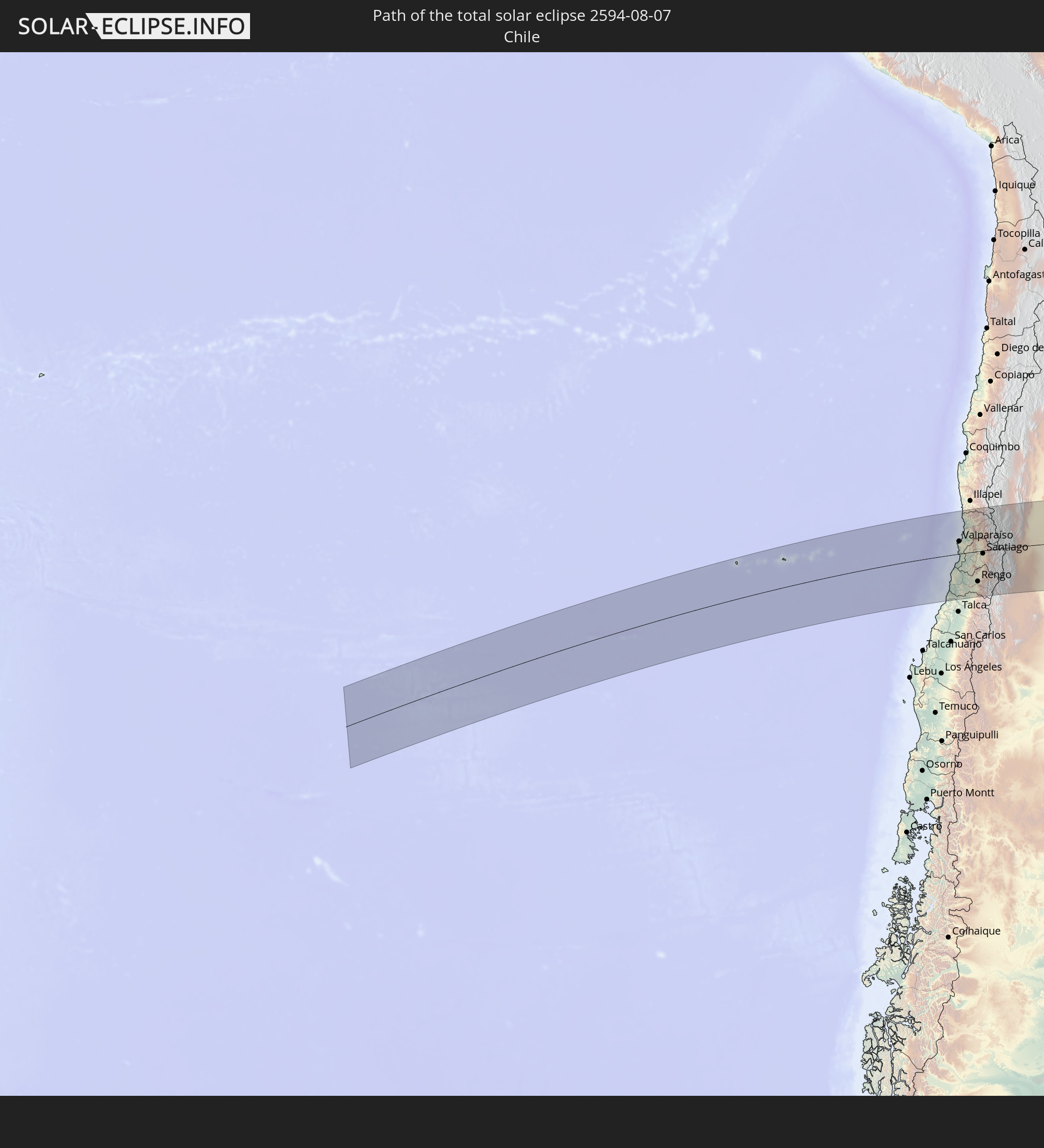 Chile
Chile
 Brazil
 Argentina
 Uruguay
In den folgenden Ländern ist die Sonnenfinsternis partiell zu sehen


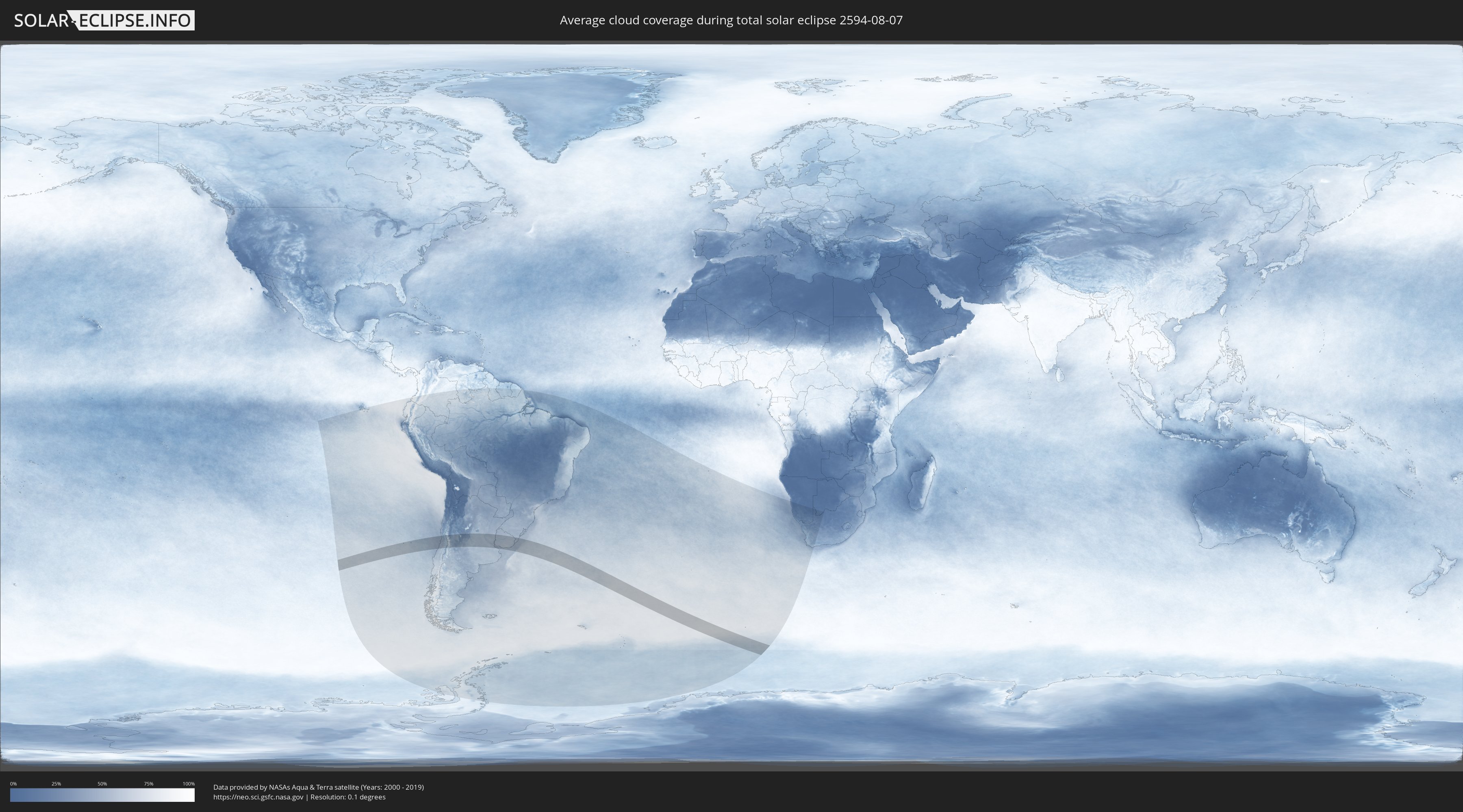
How will be the weather during the total solar eclipse on 08/07/2594?
Where is the best place to see the total solar eclipse of 08/07/2594?
The following maps show the average cloud coverage for the day of the total solar eclipse.
With the help of these maps, it is possible to find the place along the eclipse path, which has the best
chance of a cloudless sky.
Nevertheless, you should consider local circumstances and inform about the weather of your chosen
observation site.
The data is provided by NASAs satellites
AQUA and TERRA.
The cloud maps are averaged over a period of 19 years (2000 - 2019).

Detailed country maps
 Chile
Chile
 Brazil
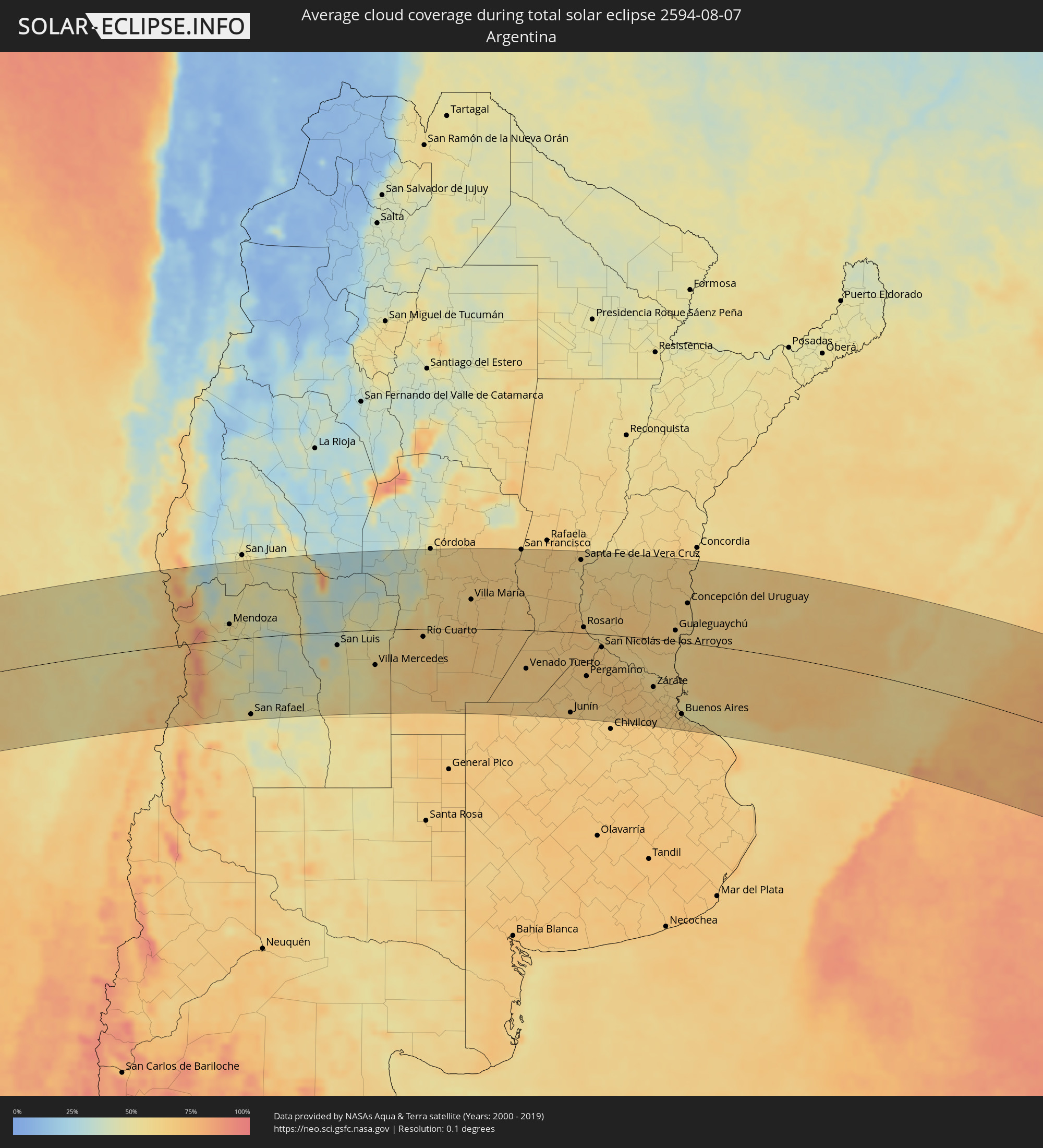 Argentina
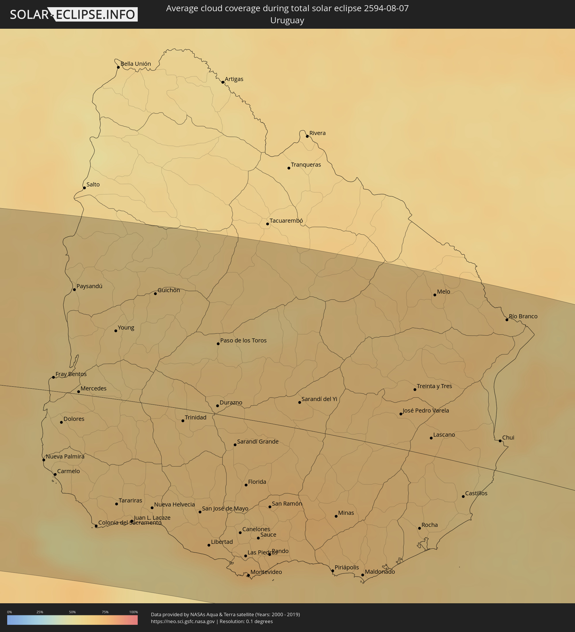 Uruguay
Cities inside the path of the eclipse
The following table shows all locations with a population of more than 5,000 inside the eclipse path. Cities which have more than 100,000 inhabitants are marked bold. A click at the locations opens a detailed map.
| City | Type | Eclipse duration | Local time of max. eclipse | Distance to central line | Ø Cloud coverage |
 Valparaíso, Valparaíso
|
total | - | 10:42:27 UTC-03:00 | 47 km | 48% |
|
Cartagena, Valparaíso
|
total | - | 10:43:07 UTC-03:00 | 10 km | 51% |
|
San Antonio, Valparaíso
|
total | - | 10:43:10 UTC-03:00 | 15 km | 51% |
|
Viña del Mar, Valparaíso
|
total | - | 10:42:32 UTC-03:00 | 48 km | 48% |
|
Quilpué, Valparaíso
|
total | - | 10:42:43 UTC-03:00 | 44 km | 50% |
|
Villa Alemana, Valparaíso
|
total | - | 10:42:49 UTC-03:00 | 43 km | 50% |
|
Santa Cruz, O'Higgins
|
total | - | 10:44:51 UTC-03:00 | 133 km | 59% |
|
Rauco, Maule
|
total | - | 10:45:17 UTC-03:00 | 165 km | 67% |
|
Limache, Valparaíso
|
total | - | 10:42:56 UTC-03:00 | 45 km | 51% |
|
Quillota, Valparaíso
|
total | - | 10:42:48 UTC-03:00 | 59 km | 49% |
|
La Ligua, Valparaíso
|
total | - | 10:42:17 UTC-03:00 | 107 km | 51% |
|
Hacienda La Calera, Valparaíso
|
total | - | 10:42:43 UTC-03:00 | 70 km | 50% |
|
Melipilla, Santiago Metropolitan
|
total | - | 10:43:51 UTC-03:00 | 30 km | 54% |
|
Teno, Maule
|
total | - | 10:45:26 UTC-03:00 | 161 km | 68% |
|
San Vicente, O'Higgins
|
total | - | 10:45:00 UTC-03:00 | 114 km | 57% |
|
San Vicente de Tagua Tagua, O'Higgins
|
total | - | 10:45:01 UTC-03:00 | 114 km | 57% |
|
Chimbarongo, O'Higgins
|
total | - | 10:45:25 UTC-03:00 | 145 km | 68% |
|
El Monte, Santiago Metropolitan
|
total | - | 10:44:11 UTC-03:00 | 32 km | 53% |
|
Llaillay, Valparaíso
|
total | - | 10:43:10 UTC-03:00 | 61 km | 47% |
|
Talagante, Santiago Metropolitan
|
total | - | 10:44:15 UTC-03:00 | 31 km | 53% |
|
Peñaflor, Santiago Metropolitan
|
total | - | 10:44:15 UTC-03:00 | 25 km | 56% |
|
Lampa, Santiago Metropolitan
|
total | - | 10:43:51 UTC-03:00 | 10 km | 54% |
|
Rengo, O'Higgins
|
total | - | 10:45:17 UTC-03:00 | 113 km | 59% |
|
Rancagua, O'Higgins
|
total | - | 10:45:09 UTC-03:00 | 89 km | 58% |
|
Buin, Santiago Metropolitan
|
total | - | 10:44:36 UTC-03:00 | 40 km | 54% |
|
Paine, Santiago Metropolitan
|
total | - | 10:44:42 UTC-03:00 | 49 km | 55% |
|
Graneros, O'Higgins
|
total | - | 10:45:03 UTC-03:00 | 78 km | 58% |
|
San Felipe, Valparaíso
|
total | - | 10:43:23 UTC-03:00 | 68 km | 49% |
|
Lo Prado, Santiago Metropolitan
|
total | - | 10:44:16 UTC-03:00 | 9 km | 66% |
|
San Bernardo, Santiago Metropolitan
|
total | - | 10:44:29 UTC-03:00 | 25 km | 57% |
|
Chicureo Abajo, Santiago Metropolitan
|
total | - | 10:44:10 UTC-03:00 | 8 km | 60% |
|
Machalí, O'Higgins
|
total | - | 10:45:18 UTC-03:00 | 91 km | 57% |
|
Santiago, Santiago Metropolitan
|
total | - | 10:44:23 UTC-03:00 | 11 km | 66% |
|
La Pintana, Santiago Metropolitan
|
total | - | 10:44:34 UTC-03:00 | 25 km | 60% |
|
Los Andes, Valparaíso
|
total | - | 10:43:41 UTC-03:00 | 57 km | 51% |
|
Villa Presidente Frei, Ñuñoa, Santiago, Chile, Santiago Metropolitan
|
total | - | 10:44:30 UTC-03:00 | 12 km | 66% |
|
Puente Alto, Santiago Metropolitan
|
total | - | 10:44:42 UTC-03:00 | 29 km | 60% |
 Mendoza, Mendoza Province
|
total | - | 10:46:27 UTC-03:00 | 33 km | 57% |
|
Pocito, San Juan Province
|
total | - | 10:45:21 UTC-03:00 | 165 km | 53% |
|
San Martín, Mendoza Province
|
total | - | 10:47:15 UTC-03:00 | 9 km | 47% |
|
San Rafael, Mendoza Province
|
total | - | 10:49:23 UTC-03:00 | 163 km | 55% |
|
Caucete, San Juan Province
|
total | - | 10:45:47 UTC-03:00 | 166 km | 52% |
|
San Luis, San Luis Province
|
total | - | 10:50:59 UTC-03:00 | 29 km | 46% |
|
Villa Mercedes, San Luis Province
|
total | - | 10:52:56 UTC-03:00 | 75 km | 58% |
|
Villa Dolores, Cordoba Province
|
total | - | 10:51:18 UTC-03:00 | 117 km | 41% |
|
Villa Carlos Paz, Cordoba Province
|
total | - | 10:51:54 UTC-03:00 | 173 km | 42% |
|
Alta Gracia, Cordoba Province
|
total | - | 10:52:18 UTC-03:00 | 148 km | 50% |
|
Río Cuarto, Cordoba Province
|
total | - | 10:54:12 UTC-03:00 | 17 km | 65% |
|
Río Tercero, Cordoba Province
|
total | - | 10:53:28 UTC-03:00 | 90 km | 61% |
|
Laboulaye, Cordoba Province
|
total | - | 10:57:05 UTC-03:00 | 128 km | 67% |
|
Villa María, Cordoba Province
|
total | - | 10:55:20 UTC-03:00 | 64 km | 64% |
|
Arroyito, Cordoba Province
|
total | - | 10:54:31 UTC-03:00 | 174 km | 65% |
|
Rufino, Santa Fe Province
|
total | - | 10:58:29 UTC-03:00 | 143 km | 67% |
|
Bell Ville, Cordoba Province
|
total | - | 10:56:36 UTC-03:00 | 40 km | 64% |
|
Marcos Juárez, Cordoba Province
|
total | - | 10:57:45 UTC-03:00 | 34 km | 64% |
|
San Francisco, Cordoba Province
|
total | - | 10:56:20 UTC-03:00 | 175 km | 63% |
|
Venado Tuerto, Santa Fe Province
|
total | - | 10:59:14 UTC-03:00 | 83 km | 66% |
|
Firmat, Santa Fe Province
|
total | - | 10:59:48 UTC-03:00 | 49 km | 64% |
|
Cañada de Gómez, Santa Fe Province
|
total | - | 10:59:14 UTC-03:00 | 23 km | 65% |
|
Gálvez, Santa Fe Province
|
total | - | 10:58:40 UTC-03:00 | 112 km | 65% |
|
Casilda, Santa Fe Province
|
total | - | 10:59:55 UTC-03:00 | 1 km | 66% |
|
Junín, Buenos Aires
|
total | - | 11:02:07 UTC-03:00 | 171 km | 67% |
|
Esperanza, Santa Fe Province
|
total | - | 10:58:33 UTC-03:00 | 177 km | 63% |
|
Capitán Bermúdez, Santa Fe Province
|
total | - | 11:00:32 UTC-03:00 | 26 km | 66% |
|
Santa Fe de la Vera Cruz, Santa Fe Province
|
total | - | 10:59:13 UTC-03:00 | 158 km | 61% |
|
Rosario, Santa Fe Province
|
total | - | 11:00:49 UTC-03:00 | 13 km | 62% |
|
Diamante, Entre Ríos Province
|
total | - | 10:59:49 UTC-03:00 | 111 km | 62% |
|
Pergamino, Buenos Aires
|
total | - | 11:02:02 UTC-03:00 | 92 km | 66% |
|
Paraná, Entre Ríos Province
|
total | - | 10:59:40 UTC-03:00 | 148 km | 59% |
|
Arroyo Seco, Santa Fe Province
|
total | - | 11:01:19 UTC-03:00 | 10 km | 69% |
|
Chacabuco, Buenos Aires
|
total | - | 11:03:05 UTC-03:00 | 174 km | 62% |
|
Villa Constitución, Santa Fe Province
|
total | - | 11:01:44 UTC-03:00 | 16 km | 66% |
|
Crespo, Entre Ríos Province
|
total | - | 11:00:25 UTC-03:00 | 117 km | 60% |
|
San Nicolás de los Arroyos, Buenos Aires
|
total | - | 11:02:04 UTC-03:00 | 28 km | 65% |
|
Victoria, Entre Ríos Province
|
total | - | 11:01:23 UTC-03:00 | 52 km | 64% |
|
Mercedes, Buenos Aires
|
total | - | 11:05:05 UTC-03:00 | 167 km | 68% |
|
Gualeguay, Entre Ríos Province
|
total | - | 11:03:38 UTC-03:00 | 1 km | 66% |
|
Luján, Buenos Aires
|
total | - | 11:05:38 UTC-03:00 | 155 km | 68% |
|
Zárate, Buenos Aires
|
total | - | 11:05:15 UTC-03:00 | 102 km | 63% |
|
Villaguay, Entre Ríos Province
|
total | - | 11:02:46 UTC-03:00 | 145 km | 62% |
|
Morón, Buenos Aires
|
total | - | 11:06:40 UTC-03:00 | 159 km | 64% |
|
San Isidro, Buenos Aires
|
total | - | 11:06:39 UTC-03:00 | 138 km | 64% |
|
Gualeguaychú, Entre Ríos Province
|
total | - | 11:05:03 UTC-03:00 | 24 km | 60% |
 Nueva Palmira, Colonia
|
total | - | 11:06:13 UTC-03:00 | 70 km | 60% |
|
Buenos Aires, Buenos Aires F.D.
|
total | - | 11:07:06 UTC-03:00 | 152 km | 64% |
|
Fray Bentos, Río Negro
|
total | - | 11:05:37 UTC-03:00 | 14 km | 62% |
|
Carmelo, Colonia
|
total | - | 11:06:37 UTC-03:00 | 83 km | 58% |
|
Quilmes, Buenos Aires
|
total | - | 11:07:27 UTC-03:00 | 164 km | 65% |
|
Concepción del Uruguay, Entre Ríos Province
|
total | - | 11:05:02 UTC-03:00 | 85 km | 61% |
|
Dolores, Soriano
|
total | - | 11:06:14 UTC-03:00 | 31 km | 63% |
|
Paysandú, Paysandú
|
total | - | 11:05:11 UTC-03:00 | 105 km | 61% |
|
Mercedes, Soriano
|
total | - | 11:06:18 UTC-03:00 | 2 km | 64% |
|
La Plata, Buenos Aires
|
total | - | 11:08:17 UTC-03:00 | 181 km | 70% |
|
Colonia del Sacramento, Colonia
|
total | - | 11:08:00 UTC-03:00 | 129 km | 53% |
|
Young, Río Negro
|
total | - | 11:06:31 UTC-03:00 | 68 km | 62% |
|
Tarariras, Colonia
|
total | - | 11:08:14 UTC-03:00 | 104 km | 66% |
|
Juan L. Lacaze, Colonia
|
total | - | 11:08:44 UTC-03:00 | 119 km | 60% |
|
Rosario, Colonia
|
total | - | 11:08:50 UTC-03:00 | 107 km | 67% |
|
Nueva Helvecia, Colonia
|
total | - | 11:09:03 UTC-03:00 | 103 km | 66% |
|
Guichón, Paysandú
|
total | - | 11:07:01 UTC-03:00 | 111 km | 62% |
|
Trinidad, Flores
|
total | - | 11:08:53 UTC-03:00 | 12 km | 65% |
|
Trinidad, Flores
|
total | - | 11:08:56 UTC-03:00 | 14 km | 65% |
|
San José de Mayo, San José
|
total | - | 11:10:08 UTC-03:00 | 100 km | 69% |
|
Libertad, San José
|
total | - | 11:10:39 UTC-03:00 | 131 km | 68% |
|
Durazno, Durazno
|
total | - | 11:09:30 UTC-03:00 | 8 km | 66% |
|
Paso de los Toros, Tacuarembó
|
total | - | 11:08:55 UTC-03:00 | 70 km | 63% |
|
Santa Lucía, Canelones
|
total | - | 11:10:55 UTC-03:00 | 107 km | 68% |
|
Delta del Tigre, San José
|
total | - | 11:11:18 UTC-03:00 | 141 km | 63% |
|
Sarandí Grande, Florida
|
total | - | 11:10:16 UTC-03:00 | 28 km | 68% |
|
Canelones, Canelones
|
total | - | 11:11:13 UTC-03:00 | 113 km | 68% |
|
La Paz, Canelones
|
total | - | 11:11:35 UTC-03:00 | 138 km | 71% |
|
Las Piedras, Canelones
|
total | - | 11:11:34 UTC-03:00 | 135 km | 73% |
|
Progreso, Canelones
|
total | - | 11:11:30 UTC-03:00 | 128 km | 73% |
|
Florida, Florida
|
total | - | 11:10:54 UTC-03:00 | 65 km | 68% |
|
Montevideo, Montevideo
|
total | - | 11:11:48 UTC-03:00 | 154 km | 62% |
|
Sauce, Canelones
|
total | - | 11:11:40 UTC-03:00 | 115 km | 70% |
|
Paso de Carrasco, Canelones
|
total | - | 11:12:02 UTC-03:00 | 147 km | 60% |
|
Joaquín Suárez, Canelones
|
total | - | 11:11:56 UTC-03:00 | 133 km | 70% |
|
Colonia Nicolich, Canelones
|
total | - | 11:12:03 UTC-03:00 | 141 km | 67% |
|
Pando, Canelones
|
total | - | 11:12:05 UTC-03:00 | 129 km | 70% |
|
San Ramón, Canelones
|
total | - | 11:11:38 UTC-03:00 | 83 km | 68% |
|
Sarandí del Yi, Durazno
|
total | - | 11:11:19 UTC-03:00 | 26 km | 67% |
|
Piriápolis, Maldonado
|
total | - | 11:13:38 UTC-03:00 | 133 km | 61% |
|
Minas, Lavalleja
|
total | - | 11:13:12 UTC-03:00 | 79 km | 70% |
|
Pan de Azúcar, Maldonado
|
total | - | 11:13:38 UTC-03:00 | 123 km | 65% |
|
Maldonado, Maldonado
|
total | - | 11:14:20 UTC-03:00 | 131 km | 63% |
|
Punta del Este, Maldonado
|
total | - | 11:14:25 UTC-03:00 | 136 km | 63% |
|
San Carlos, Maldonado
|
total | - | 11:14:18 UTC-03:00 | 119 km | 65% |
|
José Pedro Varela, Lavalleja
|
total | - | 11:13:44 UTC-03:00 | 34 km | 67% |
|
Treinta y Tres, Treinta y Tres
|
total | - | 11:13:50 UTC-03:00 | 61 km | 69% |
|
Rocha, Rocha
|
total | - | 11:15:12 UTC-03:00 | 74 km | 64% |
|
Lascano, Rocha
|
total | - | 11:14:39 UTC-03:00 | 17 km | 69% |
|
Melo, Cerro Largo
|
total | - | 11:13:25 UTC-03:00 | 159 km | 65% |
|
Castillos, Rocha
|
total | - | 11:15:55 UTC-03:00 | 33 km | 62% |
|
Chui, Rocha
|
total | - | 11:16:16 UTC-03:00 | 30 km | 62% |
 Chuí, Rio Grande do Sul
|
total | - | 11:16:16 UTC-03:00 | 30 km | 62% |
|
Río Branco, Cerro Largo
|
total | - | 11:15:20 UTC-03:00 | 150 km | 65% |
|
Jaguarão, Rio Grande do Sul
|
total | - | 11:15:19 UTC-03:00 | 154 km | 65% |
|
Santa Vitória do Palmar, Rio Grande do Sul
|
total | - | 11:16:17 UTC-03:00 | 51 km | 62% |