Totale Sonnenfinsternis vom 30.06.-0009
| Wochentag: | Samstag |
| Maximale Dauer der Verfinsterung: | 06m14s |
| Maximale Breite des Finsternispfades: | 249 km |
| Saroszyklus: | 75 |
| Bedeckungsgrad: | 100% |
| Magnitude: | 1.0753 |
| Gamma: | 0.1963 |
Wo kann man die Sonnenfinsternis vom 30.06.-0009 sehen?
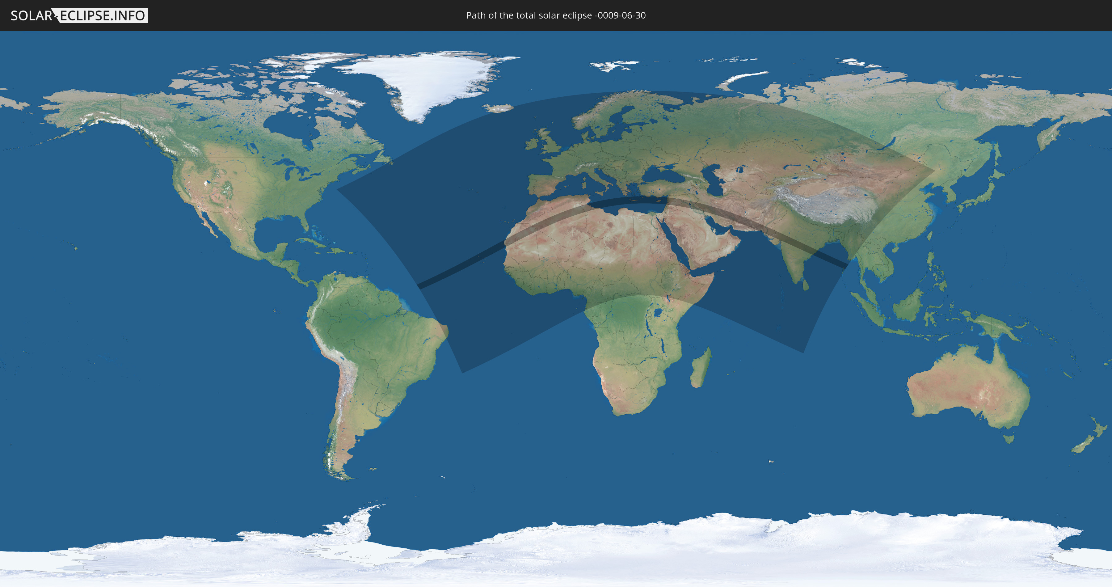
Die Sonnenfinsternis am 30.06.-0009 kann man in 126 Ländern als partielle Sonnenfinsternis beobachten.
Der Finsternispfad verläuft durch 14 Länder. Nur in diesen Ländern ist sie als totale Sonnenfinsternis zu sehen.
In den folgenden Ländern ist die Sonnenfinsternis total zu sehen
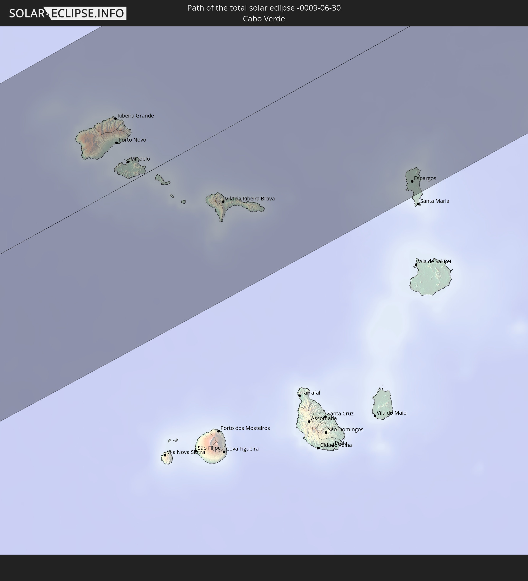 Kap Verde
 Mauretanien
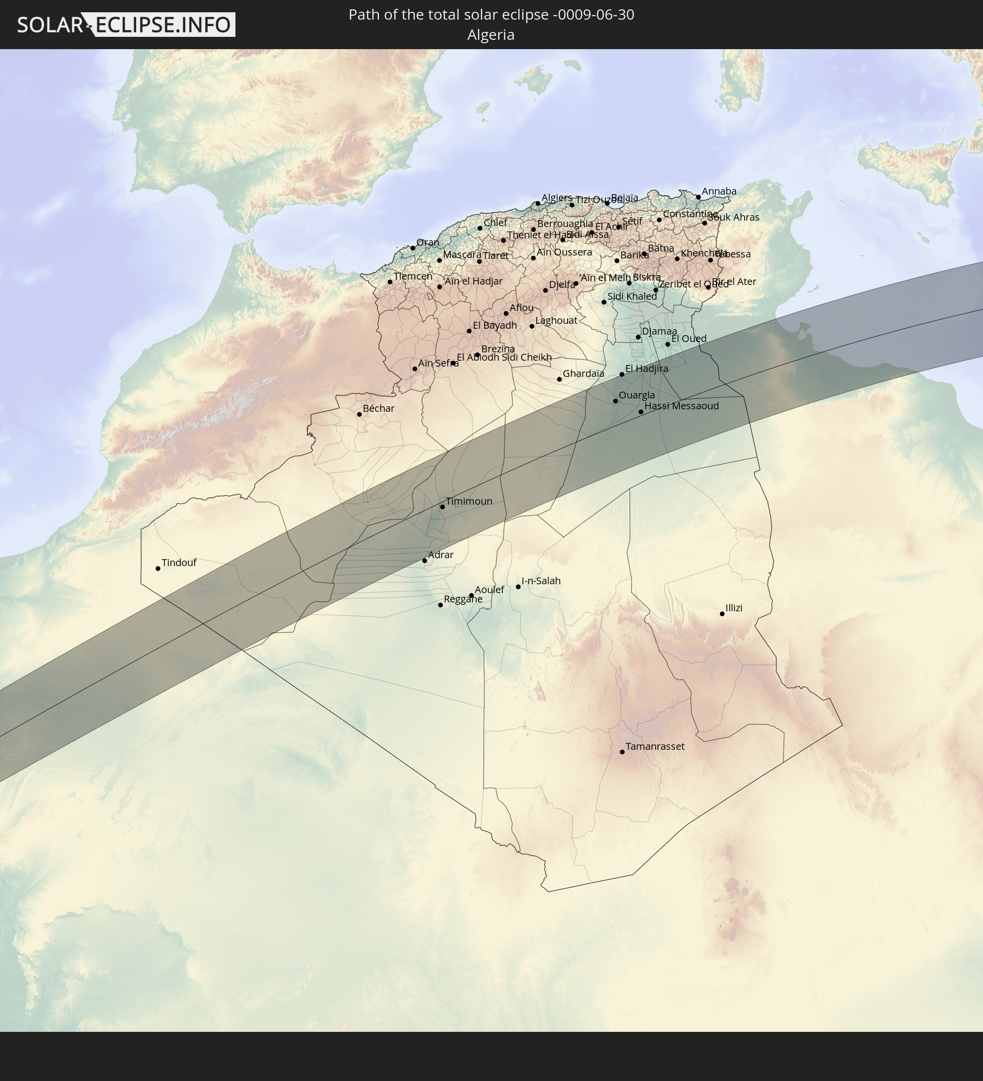 Algerien
 Tunesien
 Libyen
 Griechenland
 Türkei
 Republik Zypern
 Libanon
 Syrien
 Irak
Irak
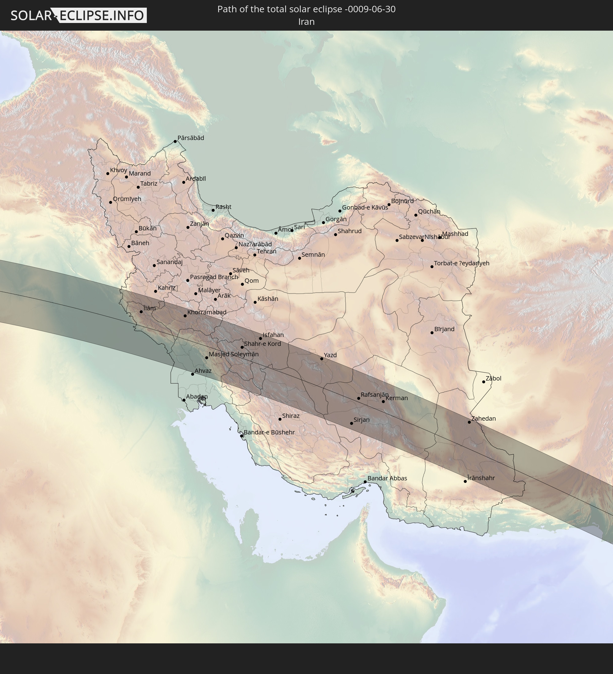 Iran
Iran
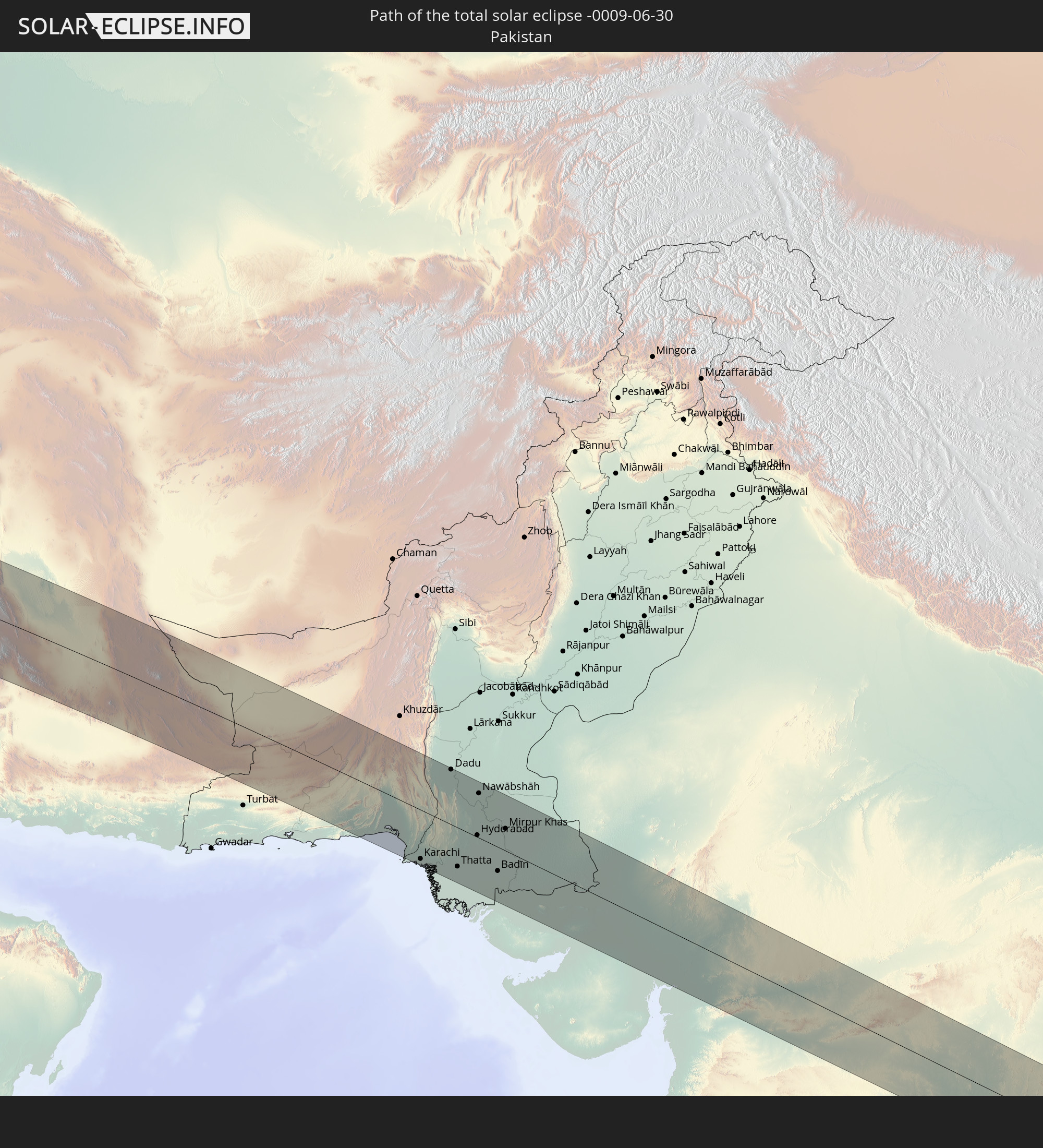 Pakistan
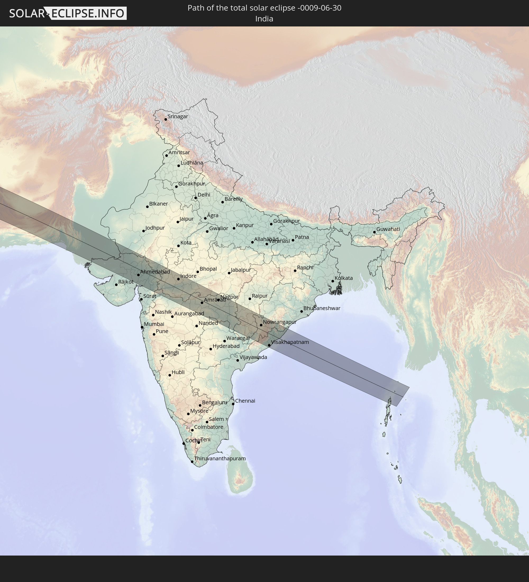 Indien
In den folgenden Ländern ist die Sonnenfinsternis partiell zu sehen
 Russland
 Kanada
 Brasilien
 Portugal
 Kap Verde
 Island
 Spanien
 Senegal
 Mauretanien
 Gambia
 Guinea-Bissau
 Guinea
 St. Helena
 Sierra Leone
 Marokko
 Mali
Mali
 Liberia
 Irland
 Algerien
 Vereinigtes Königreich
 Elfenbeinküste
 Färöer
 Burkina Faso
 Gibraltar
 Frankreich
 Isle of Man
 Ghana
Ghana
 Guernsey
 Jersey
 Togo
Togo
 Niger
Niger
 Benin
Benin
 Andorra
 Belgien
 Nigeria
 Niederlande
 Norwegen
 Äquatorialguinea
 Luxemburg
 Deutschland
 Schweiz
 São Tomé und Príncipe
 Italien
 Monaco
 Tunesien
 Dänemark
 Kamerun
 Gabun
Gabun
 Libyen
 Liechtenstein
 Österreich
 Schweden
 Republik Kongo
 Tschechien
 Demokratische Republik Kongo
 San Marino
 Vatikanstadt
 Slowenien
 Tschad
 Kroatien
 Polen
Polen
 Malta
Malta
 Zentralafrikanische Republik
 Bosnien und Herzegowina
 Ungarn
 Slowakei
 Montenegro
 Serbien
 Albanien
 Åland Islands
 Griechenland
 Rumänien
 Mazedonien
 Finnland
 Litauen
 Lettland
 Estland
 Sudan
Sudan
 Ukraine
 Bulgarien
 Weißrussland
 Ägypten
 Türkei
 Moldawien
 Uganda
 Republik Zypern
 Äthiopien
 Kenia
Kenia
 Staat Palästina
 Israel
 Saudi-Arabien
 Jordanien
 Libanon
 Syrien
 Eritrea
 Irak
Irak
 Georgien
 Somalia
 Dschibuti
 Jemen
Jemen
 Armenien
 Iran
Iran
 Aserbaidschan
 Kasachstan
 Kuwait
 Bahrain
 Katar
Katar
 Vereinigte Arabische Emirate
 Oman
Oman
 Turkmenistan
 Usbekistan
 Afghanistan
 Pakistan
 Tadschikistan
 Indien
 Kirgisistan
 Britisches Territorium im Indischen Ozean
 Malediven
 Volksrepublik China
 Sri Lanka
 Nepal
Nepal
 Mongolei
 Bangladesch
 Bhutan
 Myanmar
 Thailand
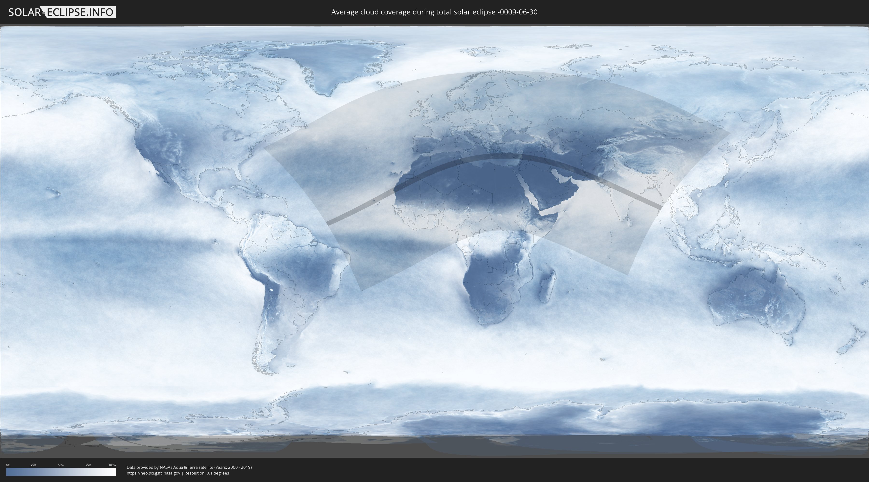
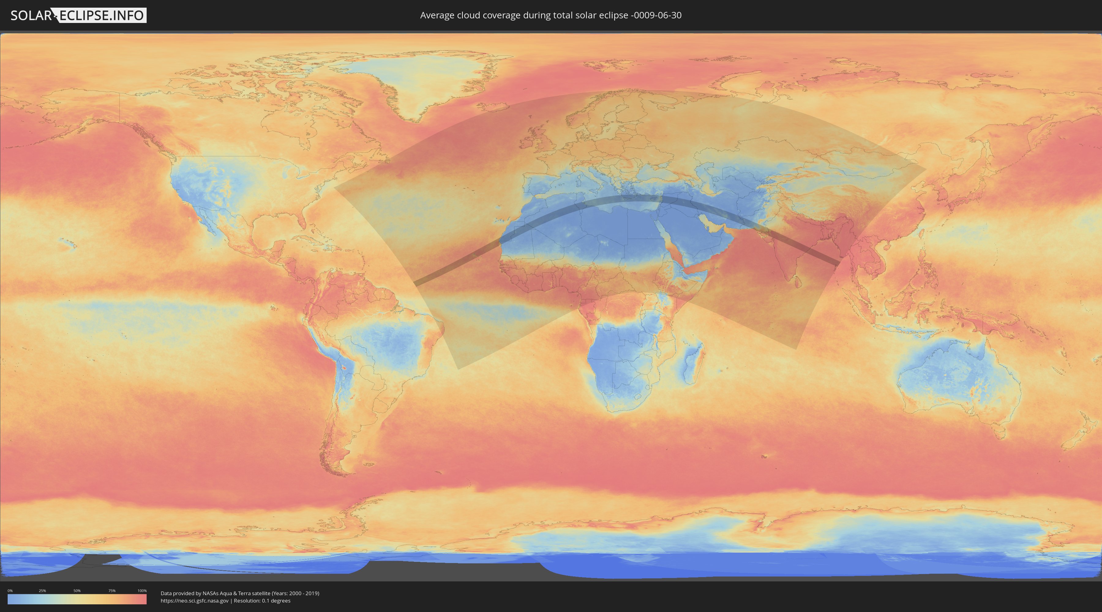
Wie wird das Wetter während der totalen Sonnenfinsternis am 30.06.-0009?
Wo ist der beste Ort, um die totale Sonnenfinsternis vom 30.06.-0009 zu beobachten?
Die folgenden Karten zeigen die durchschnittliche Bewölkung für den Tag, an dem die totale Sonnenfinsternis
stattfindet. Mit Hilfe der Karten lässt sich der Ort entlang des Finsternispfades eingrenzen,
der die besten Aussichen auf einen klaren wolkenfreien Himmel bietet.
Trotzdem muss man immer lokale Gegenenheiten beachten und sollte sich genau über das Wetter an seinem
gewählten Beobachtungsort informieren.
Die Daten stammen von den beiden NASA-Satelliten
AQUA und TERRA
und wurden über einen Zeitraum von 19 Jahren (2000 - 2019) gemittelt.
Detaillierte Länderkarten
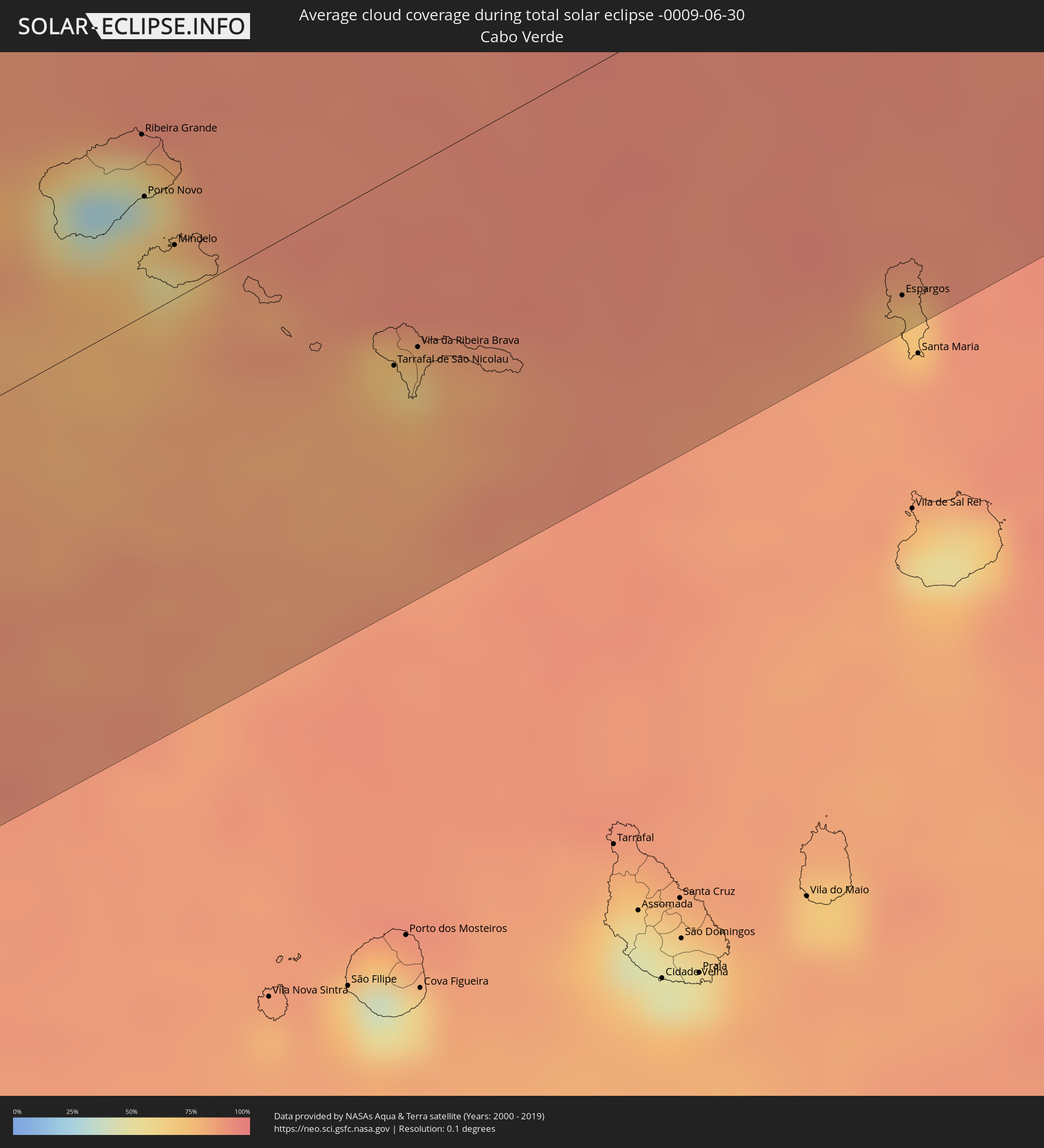 Kap Verde
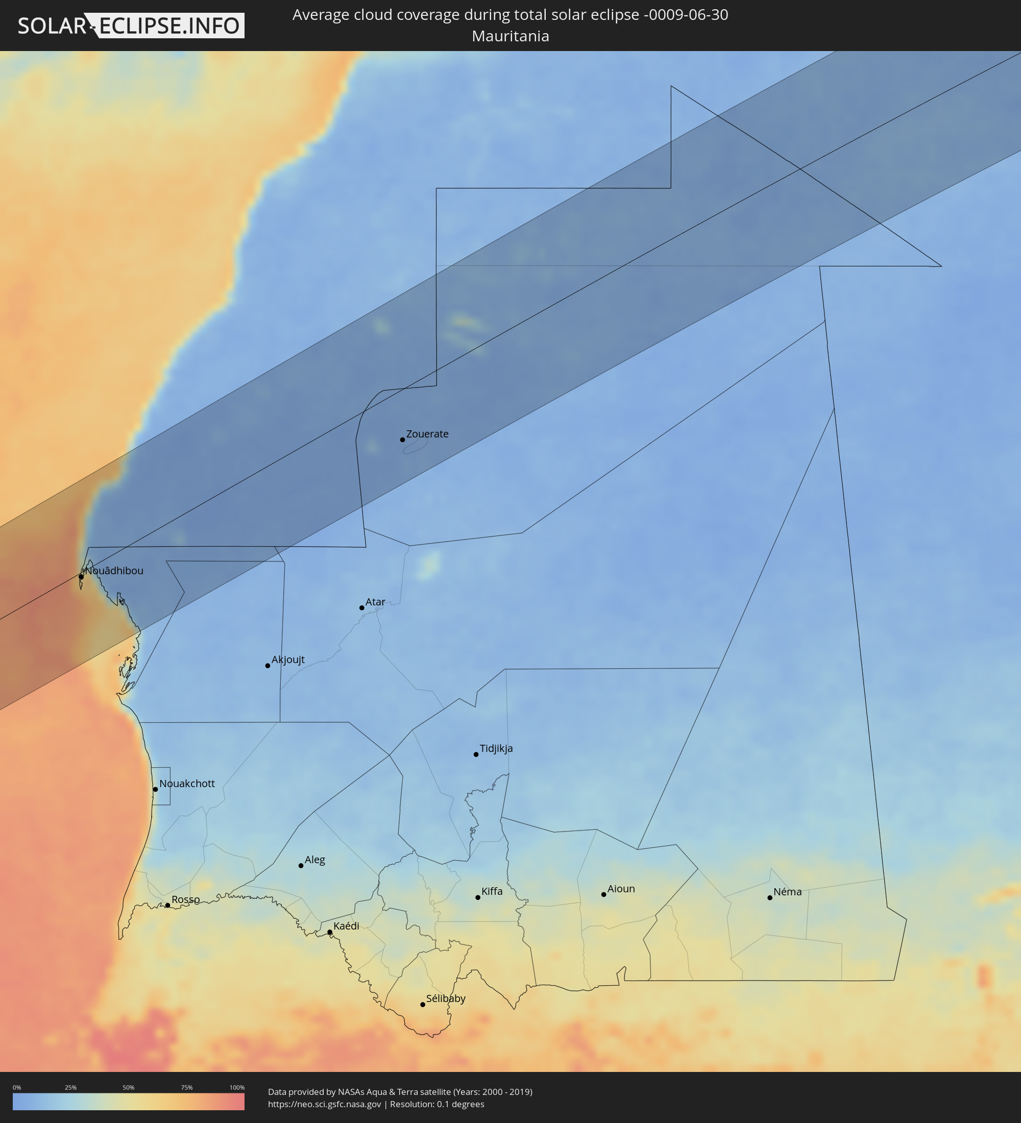 Mauretanien
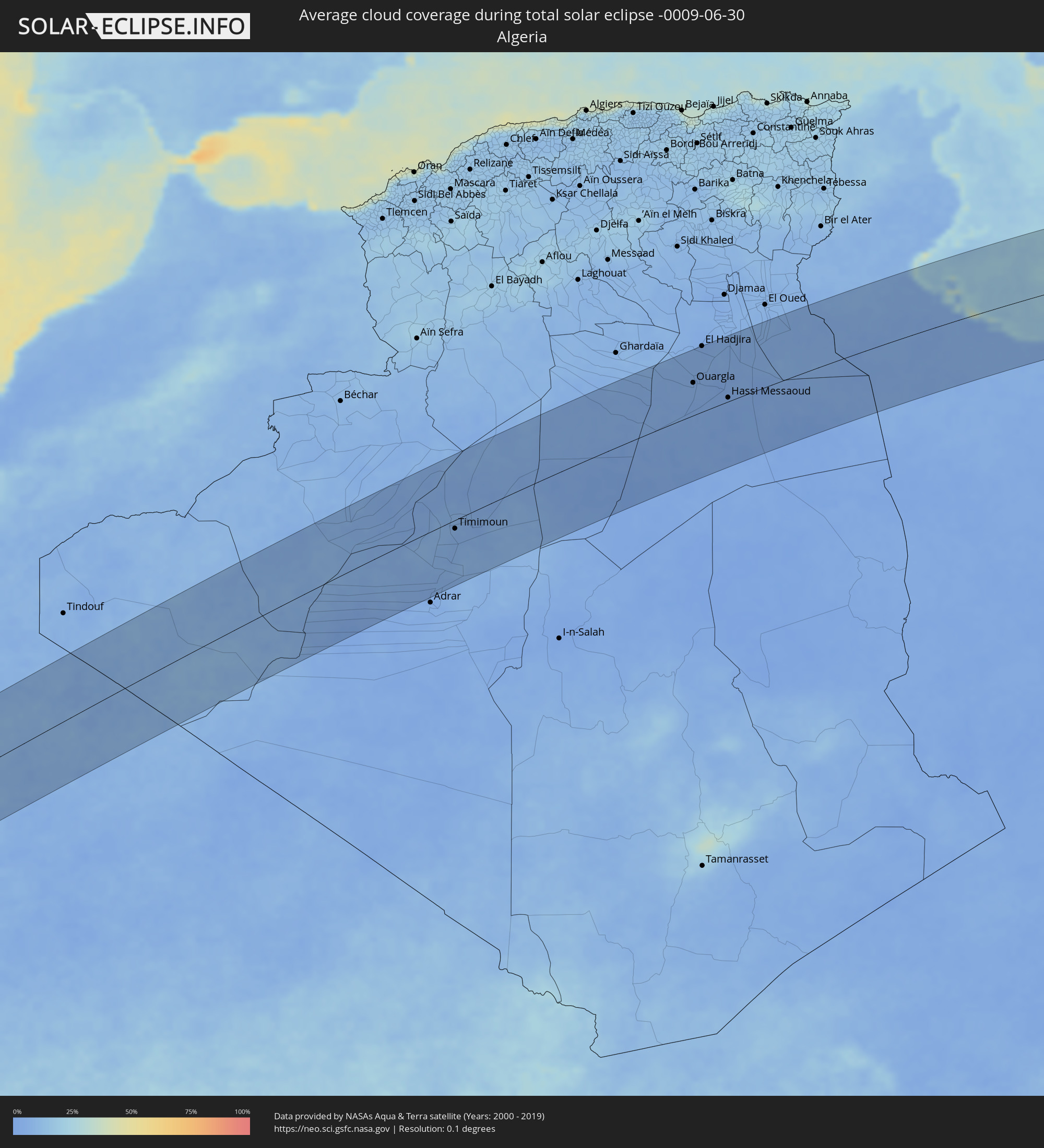 Algerien
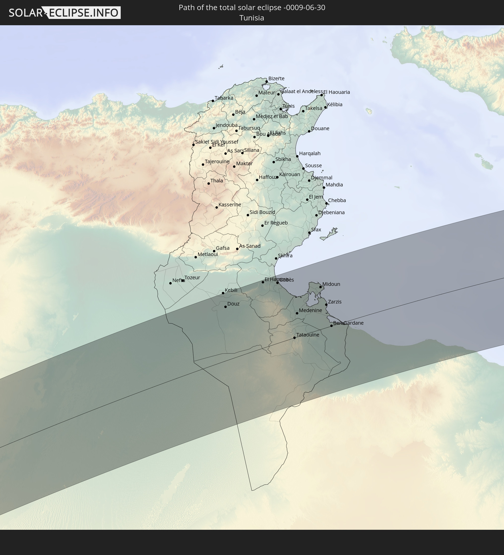
 Tunesien
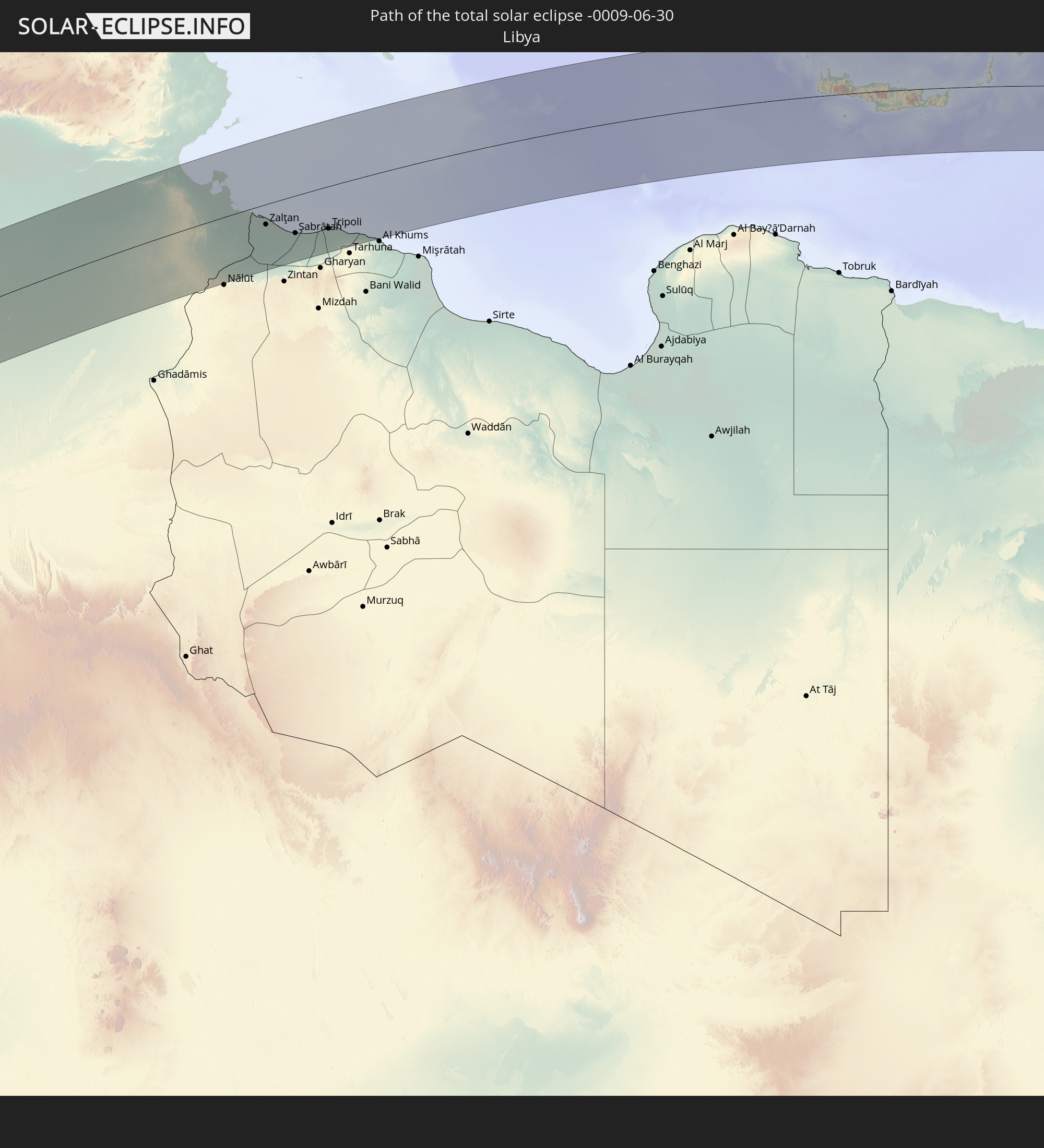
 Libyen
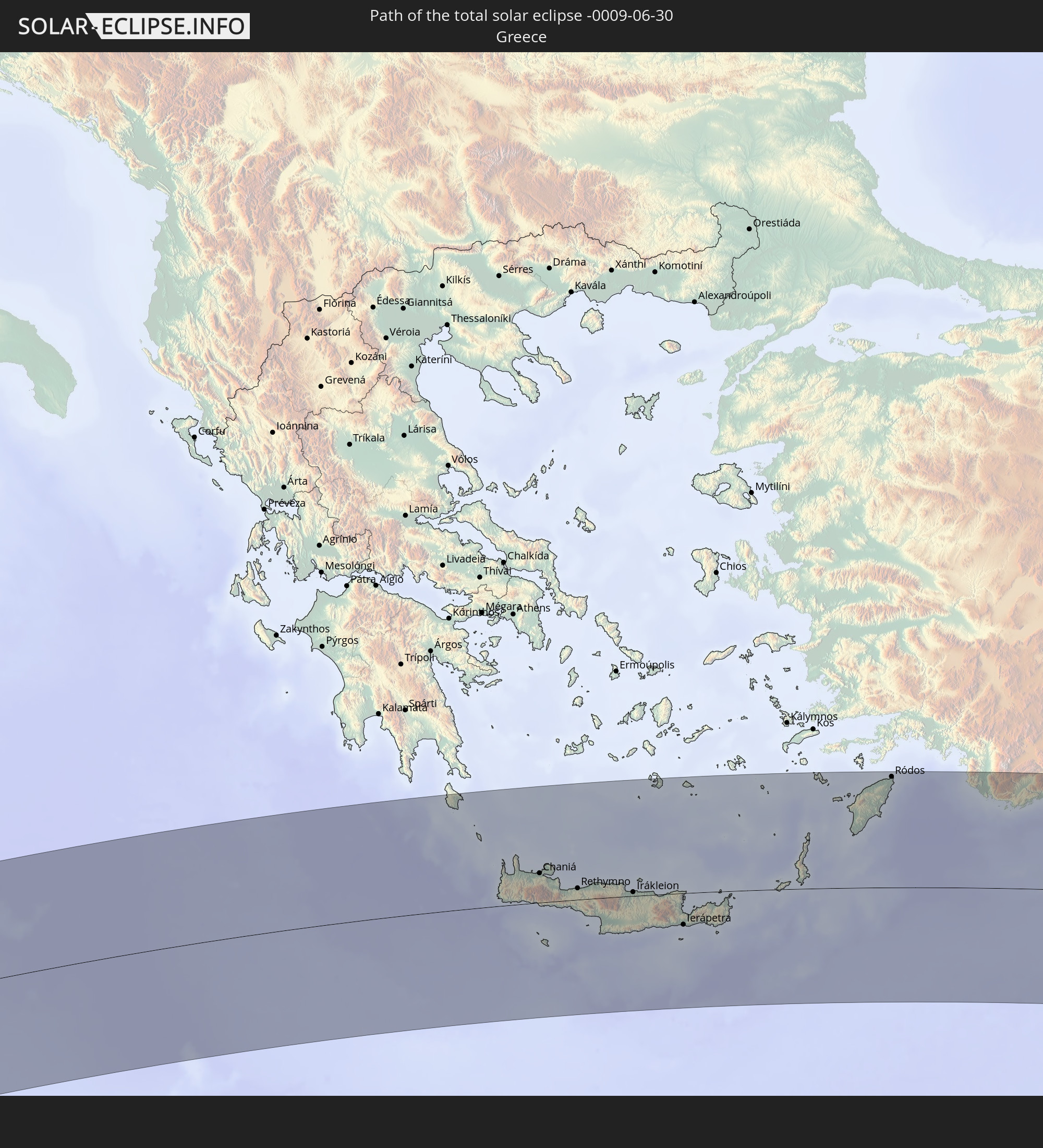
 Griechenland
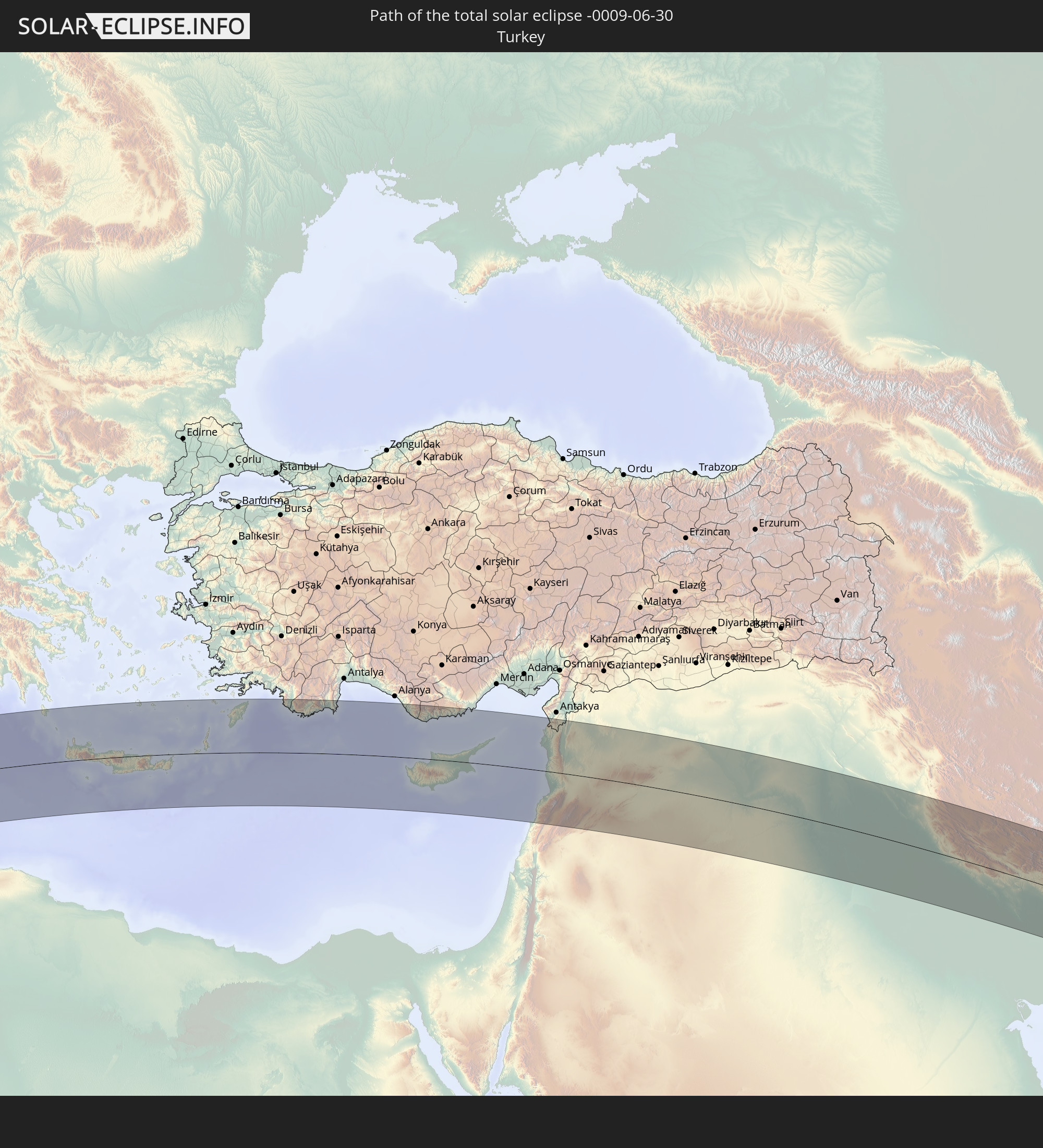
 Türkei
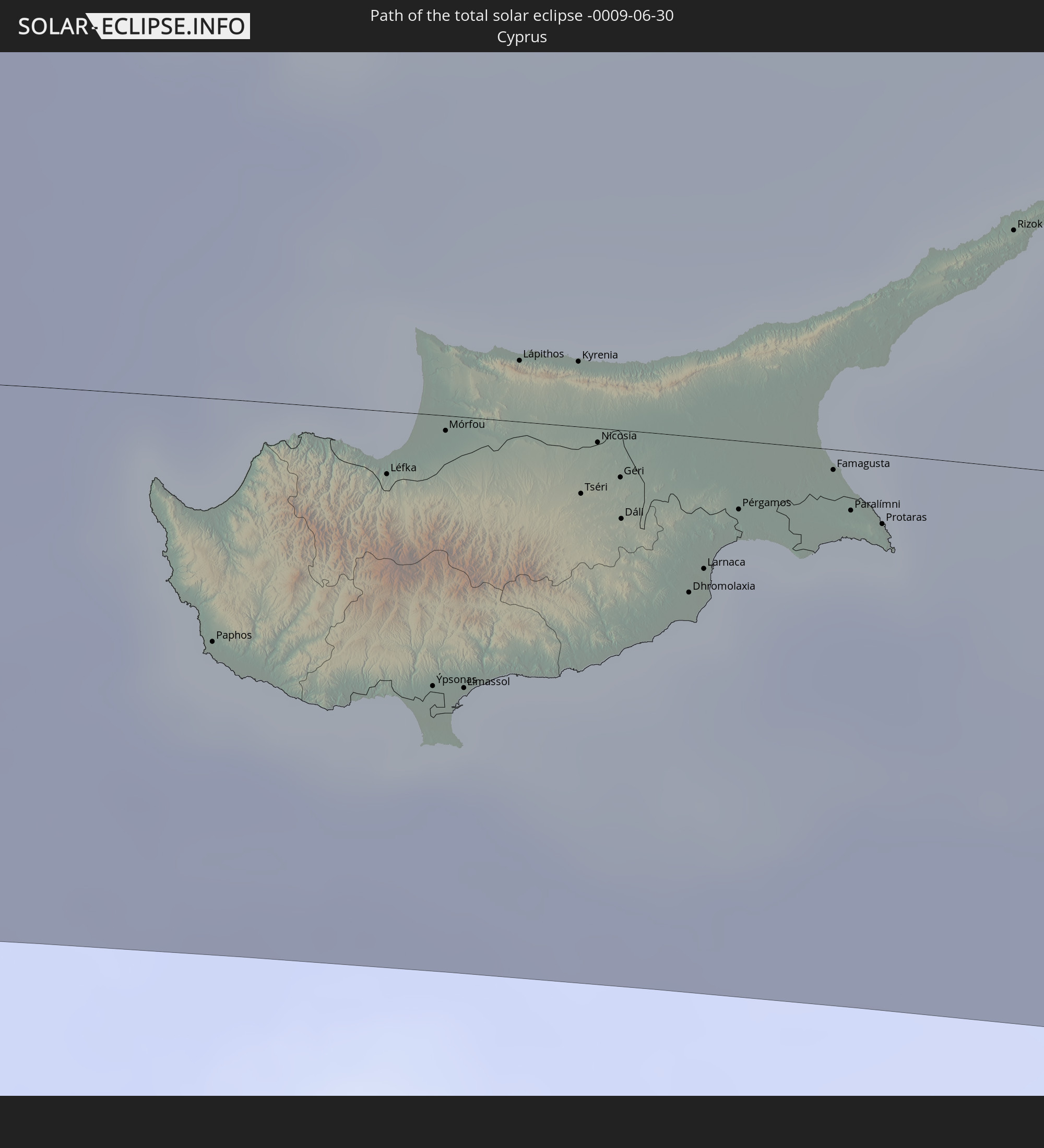
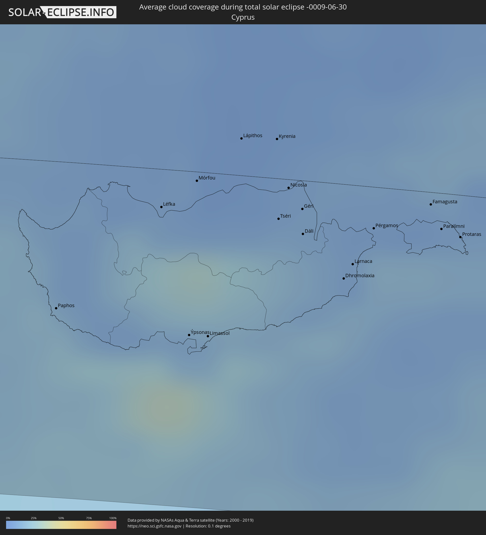 Republik Zypern
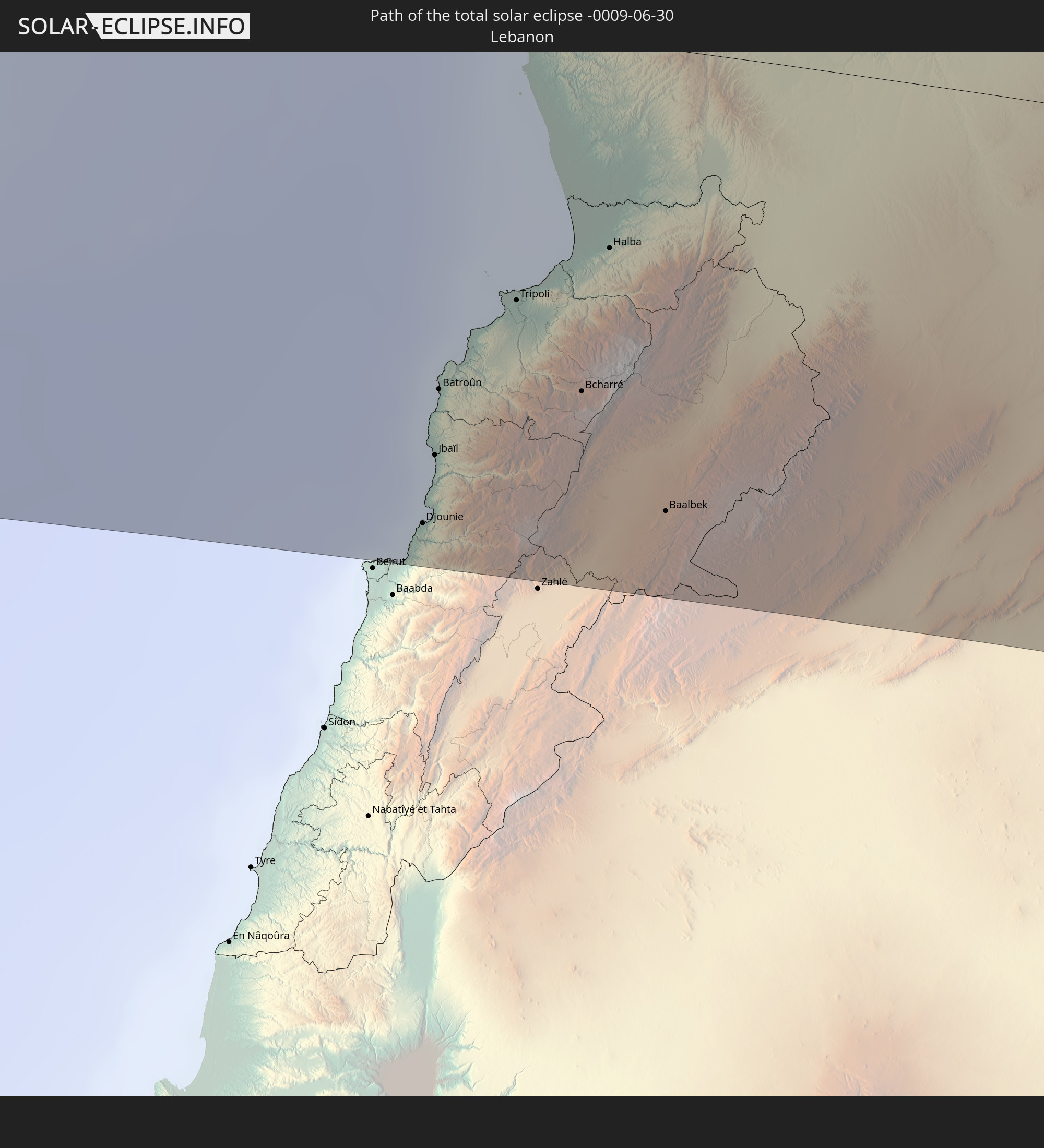
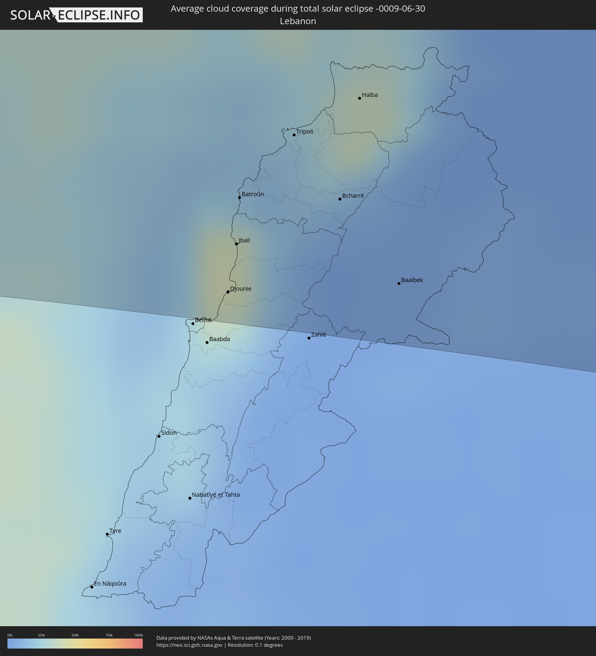 Libanon
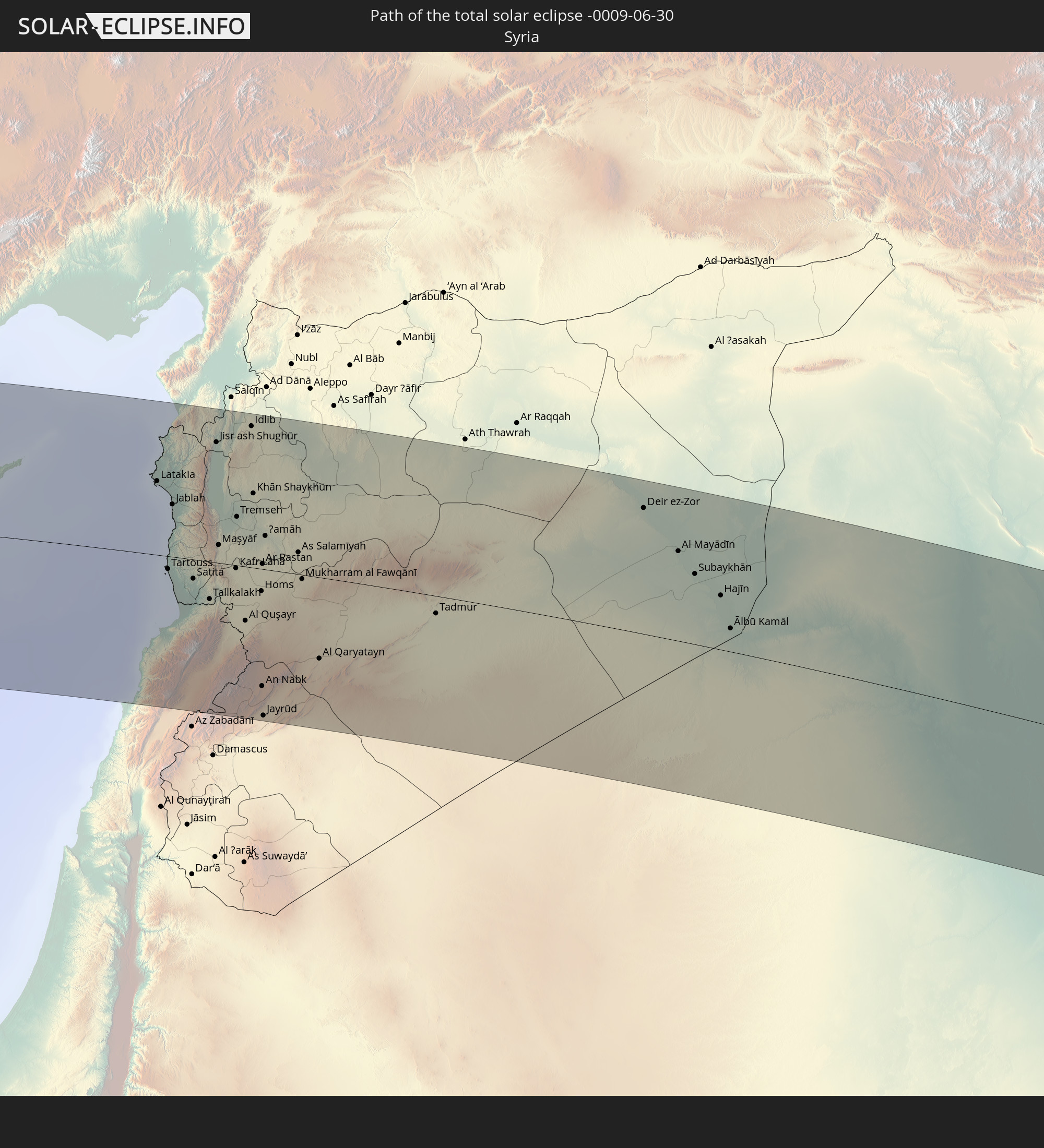
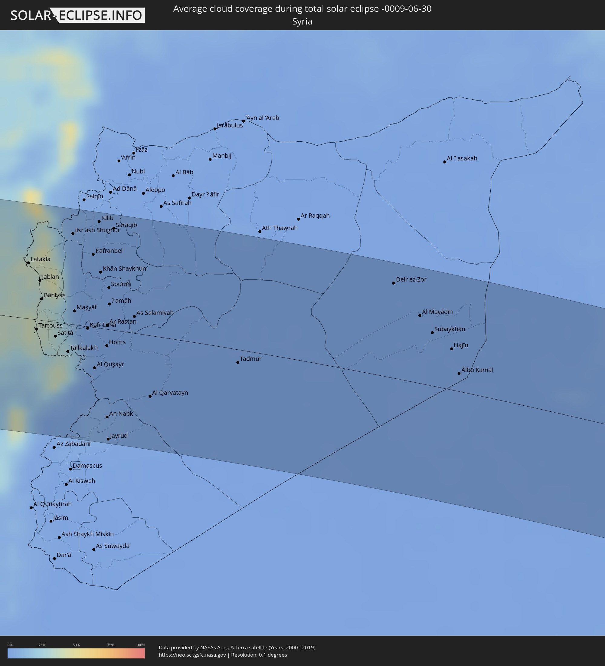 Syrien
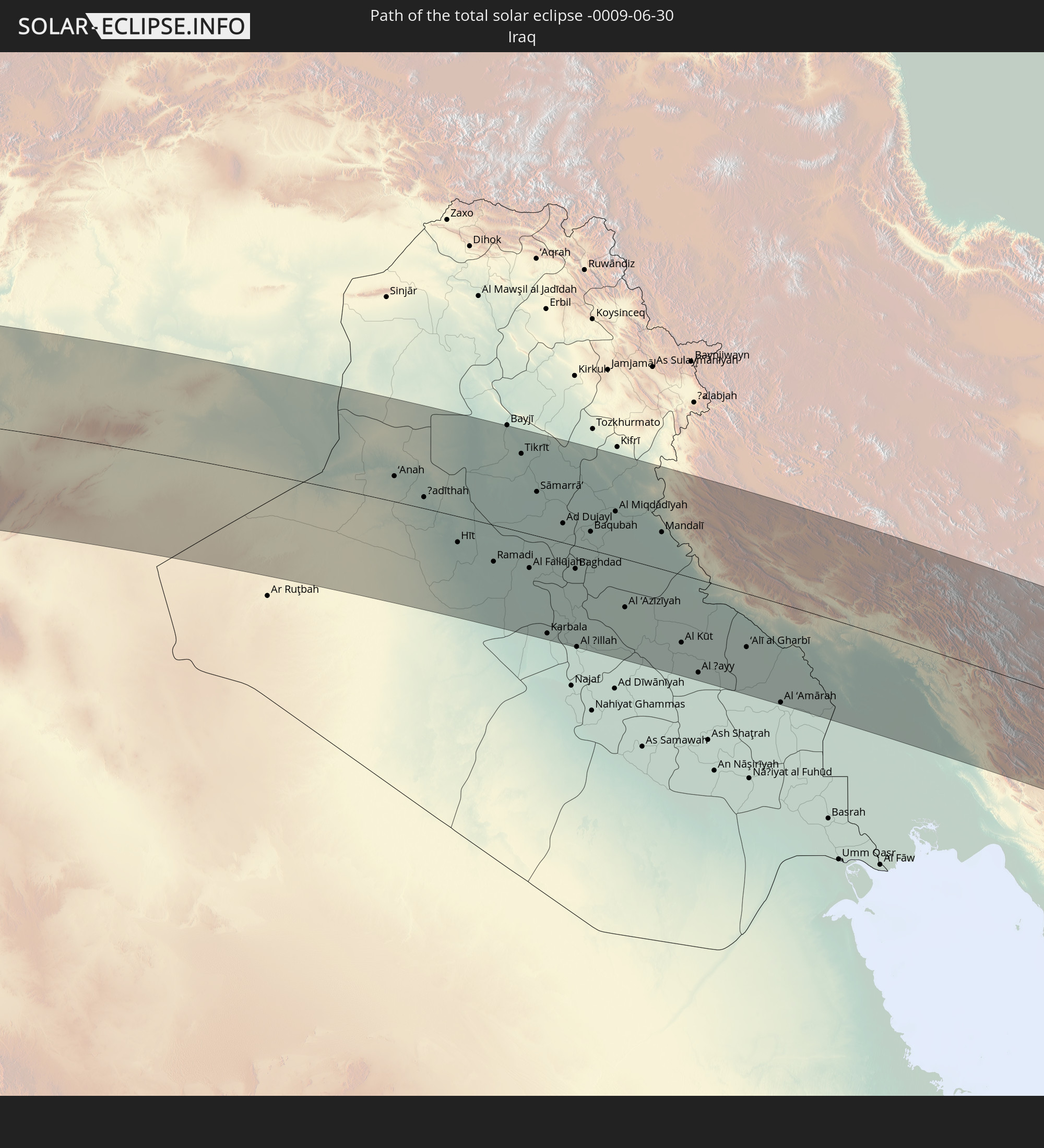
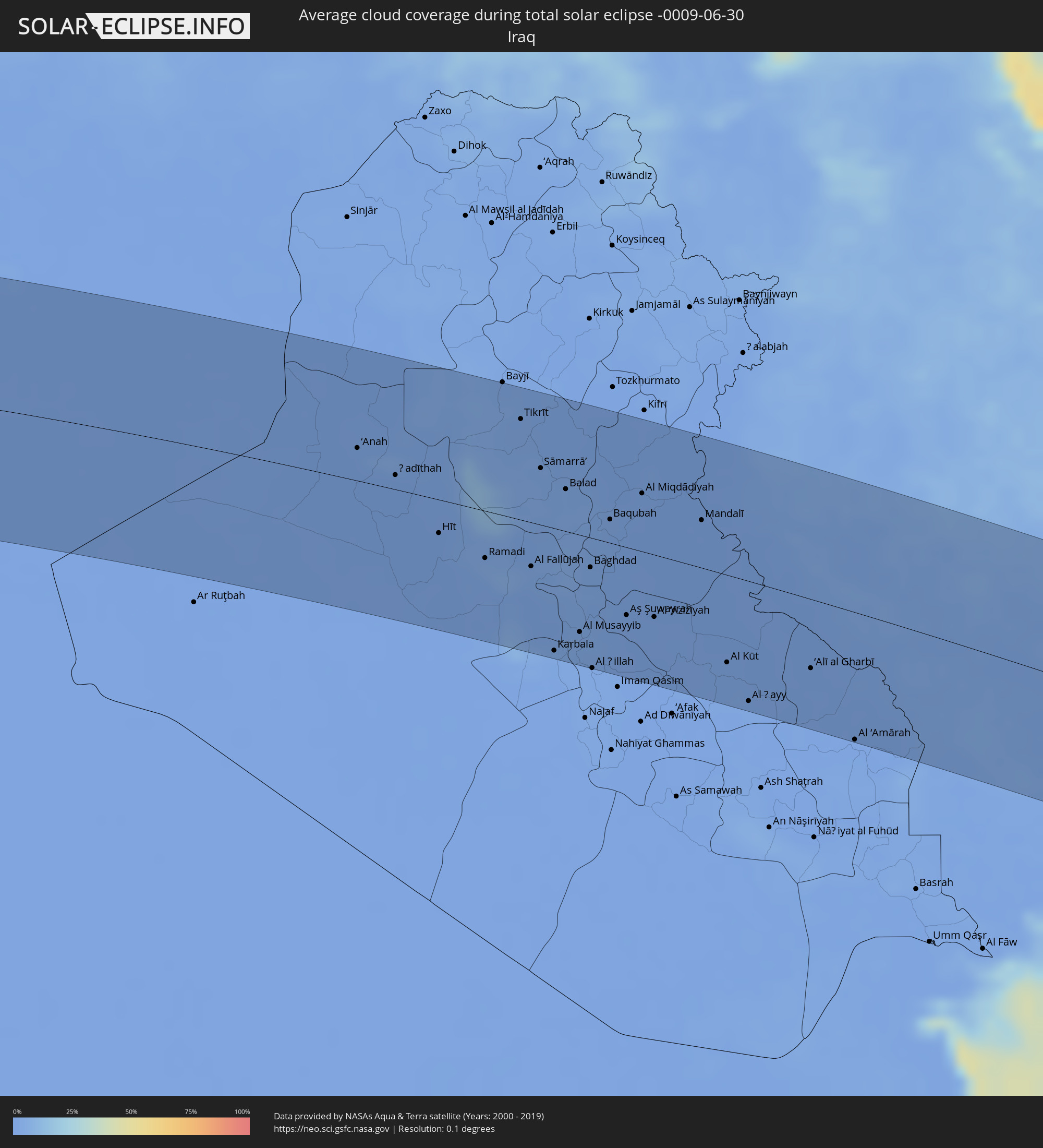 Irak
Irak
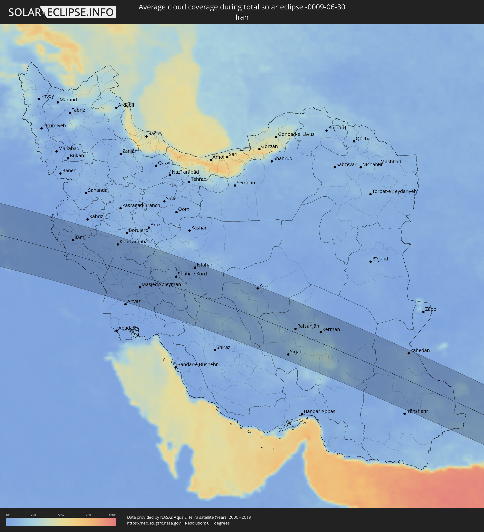 Iran
Iran
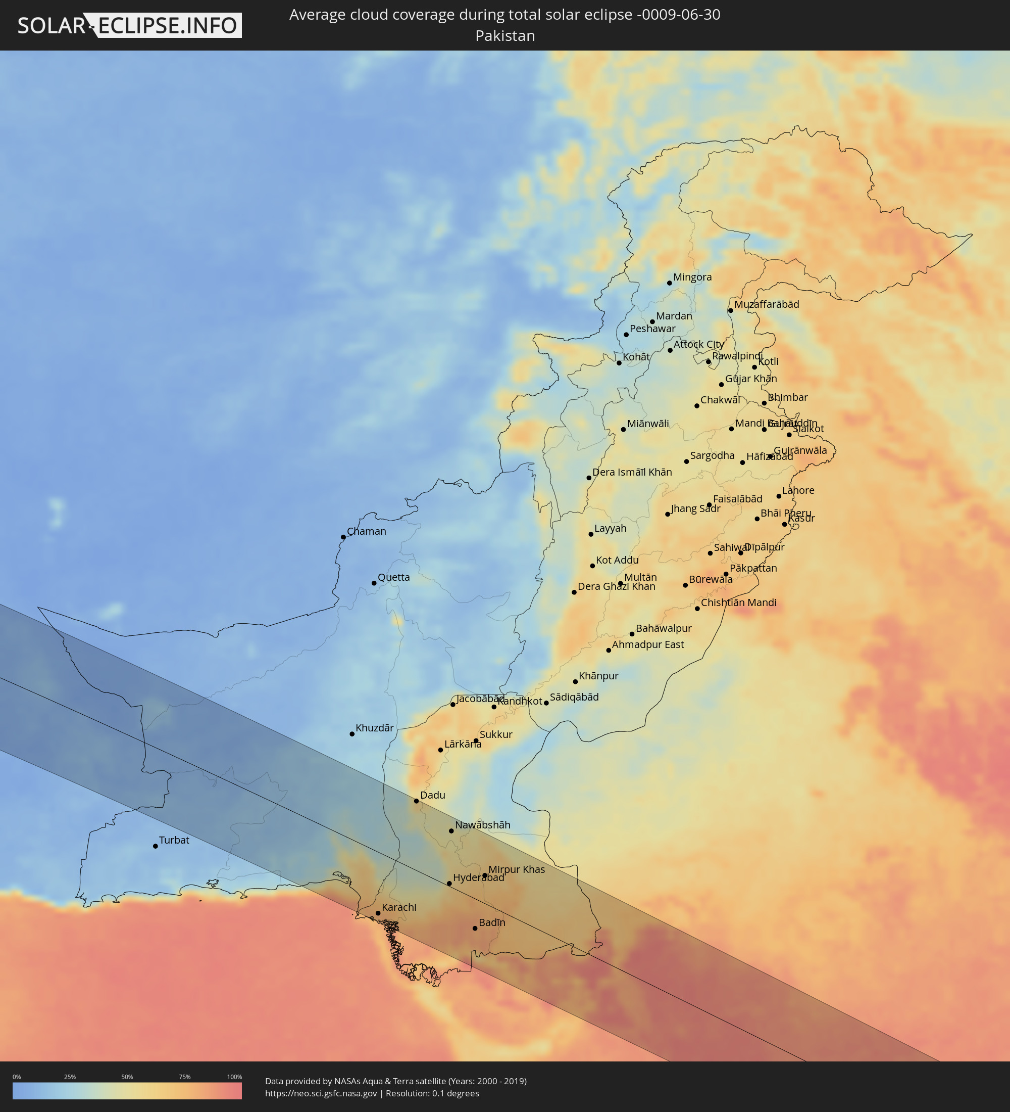 Pakistan
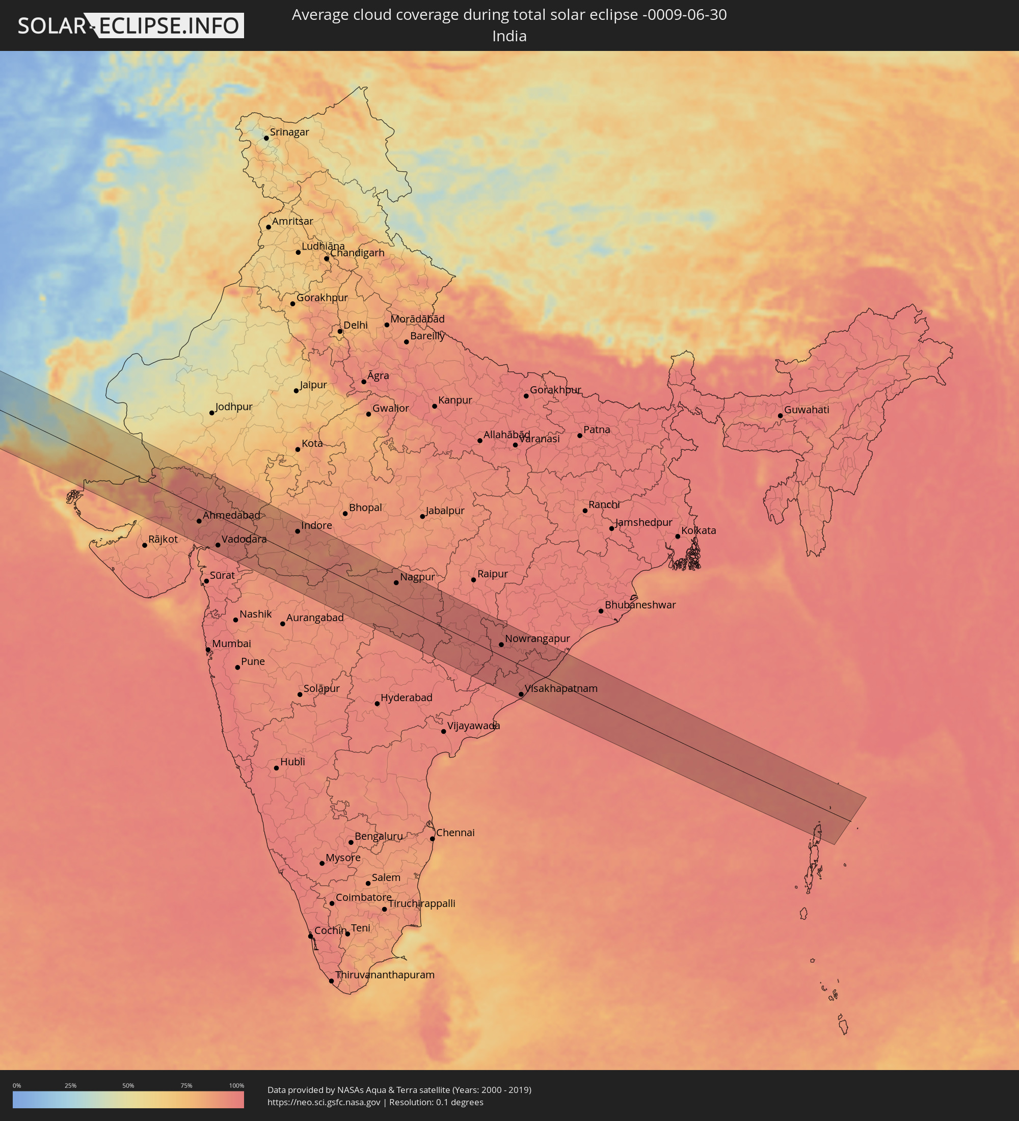 Indien
Orte im Finsternispfad
Die nachfolgene Tabelle zeigt Städte und Orte mit mehr als 5.000 Einwohnern, die sich im Finsternispfad befinden. Städte mit mehr als 100.000 Einwohnern sind dick gekennzeichnet. Mit einem Klick auf den Ort öffnet sich eine Detailkarte die die Lage des jeweiligen Ortes zusammen mit dem Verlauf der zentralen Finsternis präsentiert.
| Ort | Typ | Dauer der Verfinsterung | Ortszeit bei maximaler Verfinsterung | Entfernung zur Zentrallinie | Ø Bewölkung |
|
Ribeira Grande, Ribeira Grande
|
total | - | 07:19:22 UTC-01:34 | 47 km | 53% |
|
Porto Novo, Porto Novo
|
total | - | 07:19:13 UTC-01:34 | 31 km | 57% |
|
Pombas, Paul
|
total | - | 07:19:22 UTC-01:34 | 41 km | 74% |
|
Mindelo, São Vicente
|
total | - | 07:19:07 UTC-01:34 | 14 km | 53% |
|
Tarrafal de São Nicolau, Tarrafal de São Nicolau
|
total | - | 07:19:03 UTC-01:34 | 49 km | 72% |
|
Vila da Ribeira Brava, Ribeira Brava
|
total | - | 07:19:08 UTC-01:34 | 48 km | 64% |
|
Espargos, Sal
|
total | - | 07:19:54 UTC-01:34 | 105 km | 71% |
|
Nouâdhibou, Dakhlet Nouadhibou
|
total | - | 08:46:08 UTC-00:16 | 6 km | 67% |
|
Zouerate, Tiris Zemmour
|
total | - | 08:52:21 UTC-00:16 | 65 km | 5% |
|
Timimoun, Adrar
|
total | - | 09:43:09 UTC+00:09 | 16 km | 6% |
|
Ouargla, Ouargla
|
total | - | 09:55:28 UTC+00:09 | 61 km | 5% |
|
Rouissat, Ouargla
|
total | - | 09:55:29 UTC+00:09 | 58 km | 5% |
|
El Hadjira, Ouargla
|
total | - | 09:56:35 UTC+00:09 | 123 km | 4% |
|
Hassi Messaoud, Ouargla
|
total | - | 09:56:35 UTC+00:09 | 7 km | 3% |
|
El Golaa, Qibilī
|
total | - | 10:04:18 UTC+00:09 | 101 km | 6% |
|
Jemna, Qibilī
|
total | - | 10:04:25 UTC+00:09 | 110 km | 7% |
|
Douz, Qibilī
|
total | - | 10:04:18 UTC+00:09 | 98 km | 6% |
|
El Hamma, Qābis
|
total | - | 10:06:18 UTC+00:09 | 120 km | 5% |
|
Gabès, Qābis
|
total | - | 10:06:54 UTC+00:09 | 110 km | 11% |
|
Tataouine, Tataouine
|
total | - | 10:06:43 UTC+00:09 | 1 km | 3% |
|
Medenine, Madanīn
|
total | - | 10:07:14 UTC+00:09 | 43 km | 5% |
|
Houmt Souk, Madanīn
|
total | - | 10:08:27 UTC+00:09 | 88 km | 16% |
|
Midoun, Madanīn
|
total | - | 10:08:40 UTC+00:09 | 77 km | 23% |
|
Zarzis, Madanīn
|
total | - | 10:08:38 UTC+00:09 | 42 km | 24% |
|
Ben Gardane, Madanīn
|
total | - | 10:08:31 UTC+00:09 | 0 km | 4% |
|
Zalţan, An Nuqāţ al Khams
|
total | - | 10:53:07 UTC+00:52 | 38 km | 5% |
|
Zuwārah, An Nuqāţ al Khams
|
total | - | 10:53:34 UTC+00:52 | 46 km | 6% |
|
Şabrātah, Az Zāwiyah
|
total | - | 10:54:19 UTC+00:52 | 71 km | 8% |
|
Şurmān, Az Zāwiyah
|
total | - | 10:54:28 UTC+00:52 | 77 km | 9% |
|
Az Zāwīyah, Az Zāwiyah
|
total | - | 10:54:49 UTC+00:52 | 81 km | 8% |
|
Zawiya, Az Zāwiyah
|
total | - | 10:54:49 UTC+00:52 | 82 km | 8% |
|
Al ‘Azīzīyah, Sha‘bīyat al Jafārah
|
total | - | 10:55:16 UTC+00:52 | 113 km | 5% |
|
Tripoli, Tripoli
|
total | - | 10:55:56 UTC+00:52 | 80 km | 8% |
|
Tagiura, Tripoli
|
total | - | 10:56:18 UTC+00:52 | 83 km | 10% |
|
Chaniá, Crete
|
total | - | 12:04:20 UTC+01:34 | 32 km | 9% |
|
Soúda, Crete
|
total | - | 12:04:26 UTC+01:34 | 29 km | 9% |
|
Rethymno, Crete
|
total | - | 12:05:21 UTC+01:34 | 12 km | 9% |
|
Moíres, Crete
|
total | - | 12:06:12 UTC+01:34 | 25 km | 8% |
|
Gázi, Crete
|
total | - | 12:06:42 UTC+01:34 | 4 km | 7% |
|
Irákleion, Crete
|
total | - | 12:06:52 UTC+01:34 | 4 km | 7% |
|
Néa Alikarnassós, Crete
|
total | - | 12:06:54 UTC+01:34 | 5 km | 7% |
|
Ágios Nikólaos, Crete
|
total | - | 12:08:11 UTC+01:34 | 14 km | 9% |
|
Ierápetra, Crete
|
total | - | 12:08:13 UTC+01:34 | 34 km | 16% |
|
Sitia, Crete
|
total | - | 12:09:05 UTC+01:34 | 14 km | 10% |
|
Archángelos, South Aegean
|
total | - | 12:13:40 UTC+01:34 | 94 km | 11% |
|
Afántou, South Aegean
|
total | - | 12:13:46 UTC+01:34 | 102 km | 11% |
|
Triánta, South Aegean
|
total | - | 12:13:46 UTC+01:34 | 115 km | 9% |
|
Faliraki, South Aegean
|
total | - | 12:13:51 UTC+01:34 | 108 km | 11% |
|
Ródos, South Aegean
|
total | - | 12:13:54 UTC+01:34 | 119 km | 9% |
|
Kaş, Antalya
|
total | - | 12:39:08 UTC+01:56 | 93 km | 26% |
|
Demre, Antalya
|
total | - | 12:39:53 UTC+01:56 | 100 km | 18% |
|
Demre, Antalya
|
total | - | 12:39:54 UTC+01:56 | 99 km | 12% |
|
Turunçova, Antalya
|
total | - | 12:40:13 UTC+01:56 | 113 km | 21% |
|
Finike, Antalya
|
total | - | 12:40:14 UTC+01:56 | 105 km | 19% |
|
Beykonak, Antalya
|
total | - | 12:40:35 UTC+01:56 | 109 km | 17% |
|
Gazipaşa, Antalya
|
total | - | 12:45:00 UTC+01:56 | 111 km | 20% |
|
Paphos, Pafos
|
total | - | 13:02:14 UTC+02:13 | 54 km | 20% |
|
Anamur, Mersin
|
total | - | 12:46:11 UTC+01:56 | 93 km | 21% |
|
Léfka, Nicosia
|
total | - | 13:03:04 UTC+02:13 | 14 km | 13% |
|
Bozyazı, Mersin
|
total | - | 12:46:26 UTC+01:56 | 97 km | 17% |
|
Ýpsonas, Limassol
|
total | - | 13:03:28 UTC+02:13 | 60 km | 17% |
|
Mórfou, Nicosia
|
total | - | 13:03:21 UTC+02:13 | 3 km | 6% |
|
Limassol, Limassol
|
total | - | 13:03:38 UTC+02:13 | 60 km | 17% |
|
Kyrenia, Keryneia
|
total | - | 13:04:01 UTC+02:13 | 14 km | 7% |
|
Aydıncık, Mersin
|
total | - | 12:47:12 UTC+01:56 | 104 km | 15% |
|
Nicosia, Nicosia
|
total | - | 13:04:11 UTC+02:13 | 3 km | 10% |
|
Géri, Nicosia
|
total | - | 13:04:20 UTC+02:13 | 10 km | 11% |
|
Dáli, Nicosia
|
total | - | 13:04:22 UTC+02:13 | 20 km | 14% |
|
Aradíppou, Larnaka
|
total | - | 13:04:46 UTC+02:13 | 26 km | 9% |
|
Larnaca, Larnaka
|
total | - | 13:04:51 UTC+02:13 | 29 km | 15% |
|
Pérgamos, Larnaka
|
total | - | 13:04:59 UTC+02:13 | 15 km | 16% |
|
Famagusta, Ammochostos
|
total | - | 13:05:28 UTC+02:13 | 5 km | 8% |
|
Paralímni, Ammochostos
|
total | - | 13:05:35 UTC+02:13 | 13 km | 14% |
|
Protaras, Ammochostos
|
total | - | 13:05:46 UTC+02:13 | 15 km | 14% |
|
Djounie, Mont-Liban
|
total | - | 12:56:11 UTC+02:00 | 114 km | 35% |
|
Jbaïl, Mont-Liban
|
total | - | 12:56:10 UTC+02:00 | 98 km | 39% |
|
Batroûn, Liban-Nord
|
total | - | 12:56:08 UTC+02:00 | 83 km | 20% |
|
Latakia, Latakia
|
total | - | 13:20:59 UTC+02:25 | 60 km | 36% |
|
Tripoli, Liban-Nord
|
total | - | 12:56:27 UTC+02:00 | 61 km | 14% |
|
Tartouss, Tartus
|
total | - | 13:21:30 UTC+02:25 | 10 km | 35% |
|
Jablah, Latakia
|
total | - | 13:21:21 UTC+02:25 | 42 km | 31% |
|
Bcharré, Liban-Nord
|
total | - | 12:56:54 UTC+02:00 | 79 km | 12% |
|
Yayladağı, Hatay
|
total | - | 12:53:06 UTC+01:56 | 104 km | 26% |
|
Halba, Aakkâr
|
total | - | 12:56:54 UTC+02:00 | 46 km | 35% |
|
Baalbek, Baalbek-Hermel
|
total | - | 12:57:28 UTC+02:00 | 104 km | 2% |
|
Kafranbel, Idlib
|
total | - | 13:22:33 UTC+02:25 | 78 km | 1% |
|
Idlib, Idlib
|
total | - | 13:22:31 UTC+02:25 | 114 km | 2% |
|
Khān Shaykhūn, Idlib
|
total | - | 13:22:49 UTC+02:25 | 60 km | 1% |
|
Homs, Homs
|
total | - | 13:23:22 UTC+02:25 | 18 km | 0% |
|
An Nabk, Rif-dimashq
|
total | - | 13:23:46 UTC+02:25 | 95 km | 4% |
|
Ar Rastan, Homs
|
total | - | 13:23:17 UTC+02:25 | 4 km | 0% |
|
Ḩamāh, Hama
|
total | - | 13:23:13 UTC+02:25 | 27 km | 0% |
|
As Salamīyah, Hama
|
total | - | 13:23:54 UTC+02:25 | 18 km | 0% |
|
Tadmur, Homs
|
total | - | 13:26:43 UTC+02:25 | 14 km | 0% |
|
Deir ez-Zor, Deir ez-Zor
|
total | - | 13:29:55 UTC+02:25 | 101 km | 0% |
|
Al Mayādīn, Deir ez-Zor
|
total | - | 13:30:45 UTC+02:25 | 72 km | 0% |
|
Ālbū Kamāl, Deir ez-Zor
|
total | - | 13:32:05 UTC+02:25 | 19 km | 1% |
|
Ramadi, Anbar
|
total | - | 14:09:52 UTC+02:57 | 44 km | 3% |
|
Al Fallūjah, Anbar
|
total | - | 14:10:49 UTC+02:57 | 41 km | 2% |
|
Sāmarrā’, Salah ad Din Governorate
|
total | - | 14:10:17 UTC+02:57 | 53 km | 2% |
|
Karbala, Karbalāʼ
|
total | - | 14:11:53 UTC+02:57 | 114 km | 1% |
|
Abū Ghurayb, Mayorality of Baghdad
|
total | - | 14:11:35 UTC+02:57 | 36 km | 3% |
|
Al Hindīyah, Karbalāʼ
|
total | - | 14:12:19 UTC+02:57 | 117 km | 2% |
|
Al Musayyib, Bābil
|
total | - | 14:12:14 UTC+02:57 | 91 km | 2% |
|
Baghdad, Mayorality of Baghdad
|
total | - | 14:11:57 UTC+02:57 | 28 km | 1% |
|
Al Ḩillah, Bābil
|
total | - | 14:12:45 UTC+02:57 | 122 km | 2% |
|
Baqubah, Diyālá
|
total | - | 14:11:58 UTC+02:57 | 22 km | 1% |
|
Al Miqdādīyah, Diyālá
|
total | - | 14:12:22 UTC+02:57 | 54 km | 1% |
|
Al ‘Azīzīyah, Wāsiţ
|
total | - | 14:13:32 UTC+02:57 | 58 km | 1% |
|
Al Kūt, Wāsiţ
|
total | - | 14:15:15 UTC+02:57 | 82 km | 1% |
|
Al Ḩayy, Wāsiţ
|
total | - | 14:15:57 UTC+02:57 | 112 km | 1% |
|
Īlām, Īlām
|
total | - | 14:43:24 UTC+03:25 | 54 km | 1% |
|
Al ‘Amārah, Maysan
|
total | - | 14:18:12 UTC+02:57 | 119 km | 1% |
|
Kūhdasht, Lorestān
|
total | - | 14:45:30 UTC+03:25 | 75 km | 2% |
|
Khorramabad, Lorestān
|
total | - | 14:46:46 UTC+03:25 | 90 km | 3% |
|
Masjed Soleymān, Khuzestan
|
total | - | 14:49:50 UTC+03:25 | 47 km | 1% |
|
Shahr-e Kord, Chahār Maḩāll va Bakhtīārī
|
total | - | 14:51:52 UTC+03:25 | 42 km | 8% |
|
Najafābād, Isfahan
|
total | - | 14:52:18 UTC+03:25 | 90 km | 2% |
|
Yasuj, Kohgīlūyeh va Būyer Aḩmad
|
total | - | 14:54:41 UTC+03:25 | 110 km | 9% |
|
Isfahan, Isfahan
|
total | - | 14:52:44 UTC+03:25 | 101 km | 3% |
|
Shāhreẕā, Isfahan
|
total | - | 14:53:41 UTC+03:25 | 43 km | 5% |
|
Yazd, Yazd
|
total | - | 14:57:19 UTC+03:25 | 111 km | 3% |
|
Sirjan, Kerman
|
total | - | 15:01:42 UTC+03:25 | 96 km | 8% |
|
Rafsanjān, Kerman
|
total | - | 15:01:04 UTC+03:25 | 14 km | 9% |
|
Kerman, Kerman
|
total | - | 15:02:33 UTC+03:25 | 40 km | 8% |
|
Bam, Kerman
|
total | - | 15:05:21 UTC+03:25 | 33 km | 7% |
|
Zahedan, Sistan and Baluchestan
|
total | - | 15:07:40 UTC+03:25 | 104 km | 6% |
|
Karachi, Sindh
|
total | - | 16:20:33 UTC+04:28 | 101 km | 77% |
|
Dadu, Sindh
|
total | - | 16:19:08 UTC+04:28 | 112 km | 58% |
|
Thatta, Sindh
|
total | - | 16:21:19 UTC+04:28 | 80 km | 79% |
|
Hyderabad, Sindh
|
total | - | 16:20:57 UTC+04:28 | 4 km | 63% |
|
Nawābshāh, Sindh
|
total | - | 16:20:05 UTC+04:28 | 91 km | 50% |
|
Hāla, Sindh
|
total | - | 16:20:33 UTC+04:28 | 48 km | 54% |
|
Tando Muhammad Khān, Sindh
|
total | - | 16:21:21 UTC+04:28 | 16 km | 76% |
|
Shāhdādpur, Sindh
|
total | - | 16:20:34 UTC+04:28 | 68 km | 54% |
|
Mātli, Sindh
|
total | - | 16:21:30 UTC+04:28 | 19 km | 79% |
|
Tando Ādam, Sindh
|
total | - | 16:20:46 UTC+04:28 | 54 km | 56% |
|
Tando Allāhyār, Sindh
|
total | - | 16:21:07 UTC+04:28 | 26 km | 65% |
|
Badīn, Sindh
|
total | - | 16:22:01 UTC+04:28 | 49 km | 81% |
|
Sānghar, Sindh
|
total | - | 16:20:40 UTC+04:28 | 95 km | 56% |
|
Mirpur Khas, Sindh
|
total | - | 16:21:15 UTC+04:28 | 45 km | 68% |
|
Umarkot, Sindh
|
total | - | 16:21:52 UTC+04:28 | 61 km | 69% |
|
Ahmedabad, Gujarat
|
total | - | 17:18:44 UTC+05:21 | 45 km | 90% |
|
Nadiād, Gujarat
|
total | - | 17:19:11 UTC+05:21 | 66 km | 94% |
|
Vadodara, Gujarat
|
total | - | 17:19:43 UTC+05:21 | 90 km | 93% |
|
Ratlām, Madhya Pradesh
|
total | - | 17:19:32 UTC+05:21 | 96 km | 85% |
|
Māndu, Madhya Pradesh
|
total | - | 17:20:34 UTC+05:21 | 16 km | 87% |
|
Indore, Madhya Pradesh
|
total | - | 17:20:25 UTC+05:21 | 72 km | 89% |
|
Dewas, Madhya Pradesh
|
total | - | 17:20:15 UTC+05:21 | 107 km | 88% |
|
Burhānpur, Madhya Pradesh
|
total | - | 17:21:50 UTC+05:21 | 51 km | 89% |
|
Punāsa, Madhya Pradesh
|
total | - | 17:21:03 UTC+05:21 | 49 km | 87% |
|
Akola, Maharashtra
|
total | - | 17:22:36 UTC+05:21 | 75 km | 91% |
|
Amrāvati, Maharashtra
|
total | - | 17:22:38 UTC+05:21 | 18 km | 90% |
|
Nagpur, Maharashtra
|
total | - | 17:22:48 UTC+05:21 | 64 km | 92% |
|
Chānda, Maharashtra
|
total | - | 17:23:52 UTC+05:21 | 45 km | 93% |
|
Nowrangapur, Odisha
|
total | - | 17:24:59 UTC+05:21 | 33 km | 97% |
|
Visakhapatnam, Andhra Pradesh
|
total | - | 17:26:14 UTC+05:21 | 92 km | 95% |